

How High Do Planes Fly? Airplane Flight Altitude

Fuel Efficiency
Avoiding traffic and other hazards, weather and turbulence, safely factors, airplane news update, emergencies, a word about light aircraft.
- And Finally...
Most airline passengers simply accept the fact that passenger jets fly very high. They rarely ask about it, or want to know what altitude is used. But there are good reasons for how high planes fly.
In fact, the common cruising altitude for most commercial airplanes is between 33,000 and 42,000 feet, or between about six and nearly eight miles above sea level. Typically, aircraft fly around 35,000 or 36,000 feet above sea level. This is why when you are on a long flight, you will generally hear the captain say something like, “Ladies and gentlemen, we have now reached our cruising altitude of 36,000 feet”.
Commercial airplanes can theoretically fly a little higher than this, and of course they can also fly lower if they choose to. But small aircraft such as those flown by private pilots cannot fly this high, and usually do not go above 10,000 feet. Indeed, they often fly much lower than this.
There are a number of reasons for all of the above, which we will take a look at now.
Ultimate Guide to Becoming a Pilot
The main reason for airliners flying so high is that it saves fuel and therefore saves money, which is always a priority for airlines. The air becomes thinner as the altitude increases, and thin air creates less drag on the aircraft. In addition, jet engines operate more efficiently at high altitudes, meaning the plane can travel faster while at the same time burning less fuel.
However, a plane’s engines need oxygen in order to function, so flying too high can also cause problems. Plus if a plane goes higher, it has to burn more fuel in order to get there. So there has to be a balance, which is the reason for the fairly specific altitudes generally used by airliners. 35,000 feet or thereabouts is the altitude at which fuel efficiency is greatest, while there is still enough oxygen available to power the engines.
Flying higher means that commercial airplanes can avoid most other airborne traffic. At the altitudes they use, there will be no light aircraft and helicopters, and no drones, which all fly much lower.
Birds rarely fly that high, which is important, as bird strikes, though rare, can be disastrous if they happen. An extreme case of this sort of disaster was the US Airways aircraft which was forced to land on the Hudson river after a bird strike. This sort of thing is extremely unlikely, but it does happen occasionally.

It is not essential for aircraft to avoid bad weather, but it is a good idea. Commercial airplanes usually fly above the troposphere, which is the part of the atmosphere where weather events usually happen. The troposphere is usually said to finish at 36,000 feet. This is why when you are cruising in an airliner, it is usually bright and sunny, with all the cloud and rain below you.
Turbulence is less common at high altitudes too. Again, airliners can generally cope with turbulence, but it is preferable to avoid it if possible.

Over 42,000 flights take place every day, with 5,000 planes in the sky at any one time, according to the FAA. With this much traffic, there has to be some official arrangement to make sure collisions do not happen, and there is.
There are certain rules for exactly where airliners can fly, and the direction of travel can affect what altitude they will climb to. Planes flying eastward, including northeast and southeast, will fly at odd altitudes, such as 35,000 feet. Planes flying in approximately westerly directions have to fly at even altitudes. This means that planes flying in opposite directions to each other are at least 1000 feet apart, so avoiding a possible collision and making for safer flights.
Lastly, flying high gives you more time to act in the unlikely event of an emergency in flight. Modern airliners are incredibly safe most of the time, but should something happen which means an emergency landing is required, high altitude gives the pilots much longer to sort things out and find a safe place to land.
On the other hand, flying too high could have negative safety issues. In some emergencies, such as a rapid decompression, pilots want to return to a lower altitude as quickly as possibe. So again, there has to be a balance, which accounts for the altitudes generally used.
While jet engines operate well at high altitudes, the same is not true of piston engines, which are typically used for light aircraft of the type flown by most private pilots. Piston engines do not operate well in thin air, and this is one of the reasons why most small planes fly at altitudes of below 15,000 feet.

But in fact, small aircraft generally fly much lower than that for a variety of other reasons. This is partly because they tend to fly shorter distances, and pilots simply do not want to spend too much time climbing and descending on a short flight; it just isn’t worth it. Also, most small planes are not equipped with oxygen, which would be necessary if they were to fly too high. It is probably not really safe for them to be much above 10,000 feet. And a substantial majority of small planes are flown for recreational purposes, and pilots enjoy flying lower, where they can see things below them. This is not a factor in commercial flying.
However, legally planes must be at least 1000 feet above any object on the ground, and must be able to land clear of any congested area in the event of an engine failure. Therefore small planes generally fly between 2000 and 10,000 feet. It all makes sense when you know the reasons for it!
And Finally…
It should be noted that every airplane has a certified maximum altitude. During test flights this maximum is exceeded slightly to verify the that airplane remains safe should it have cause to ascend from that limit. The highest certified altitude of an airliner was Concorde’s 60,000 feet. Today some of the corporate jets can fly at 51,000 feet.
However, for all the reasons mentioned above, this is mainly theoretical, and most commercial airplanes fly much lower than this.
Similar Articles

Aircraft Registration: How to Register a Plane

The 2023 Pilot Shortage – Here We Go Again

How to Become Current as a Pilot

Scored % on their FAA Exam
Here’s How High Planes Actually Fly, According to Experts
O ver 42,000 planes take flight in the U.S. every day, with 5,000 in the sky at any given time, according to the Federal Aviation Administration . Coordinating that many arrivals, departures and flights without collisions requires masterful planning, particularly when it comes to how high planes fly.
It turns out there’s a specific altitude range airplanes must stay in while flying because of a few factors like the type of aircraft, the distance to your destination, the type of engine they have, the strength of the winds and the weight of the airplane.
Here’s what to know about how high planes really fly:
How high do planes actually fly?
One reason that planes cruise above the clouds is so they can fly fast. The higher airplanes climb, the thinner the air gets , and the more efficiently they can fly because of less resistance in the atmosphere, according to Ryan Jorgenson, an aviation data analyst.
“With these larger jets, when they take off from airports, their first job is essentially to get out and get as high as possible as quickly as possible,” says Adam Beckman, a lecturer for aviation studies at Ohio State University.
Commercial aircraft typically fly between 31,000 and 38,000 feet — about 5.9 to 7.2 miles — high and usually reach their cruising altitudes in the first 10 minutes of a flight, according to Beckman.
Planes can fly much higher than this altitude, but that can present safety issues. Flying higher means it would take a longer time to return to a safe altitude in case of an emergency, like rapid decompression, Beckman says. It also isn’t the most efficient use of fuel to fly that high in the first place, he says, since planes can fly at a lower altitude with the assistance of wind.
Another reason why planes don’t fly higher is due to the weight of the aircraft . “The more you weigh, the harder it is to get to a certain altitude,” says Jorgenson.
And the weight of the plane changes as the aircraft climbs higher into the sky. “Jet fuel weighs about 6.7 pounds per gallon, so the more that you burn as you’re flying, you would actually end up losing a lot of fuel weight,” Jorgenson says. This, combined with the thinner atmosphere at this height, creates less resistance.
The direction of the wind is also an important factor. “If I’m flying to Europe from Philadelphia, it’s going to take me less time to go over there than go back,” says Bob Cowgill, Managing Director at ACI Aviation Consulting. “Oftentimes you will find that you will fly at higher altitudes when the winds are at your back.”
An airplane’s potential speed also increases the higher it goes. “Ten thousand feet and above, you can go legally to a much higher speed,” says Dr. Thomas Carney, Professor of Aviation and Transportation Technology at Purdue University. This also explains why you feel the plane slowing down during landing.
Why don’t small private planes or helicopters fly at the same height?
So why don’t small private planes fly as high? In most cases, these planes use a piston-powered engine, which operates similarly to the engine in your car and with power that only allows for shorter flights, according to the National Business Aviation Association . This type of engine prevents these smaller planes from reaching the same altitudes as commercial aircraft.
“The plane that the average guy can rent and fly, those tend to stay usually below 15,000 feet and that’s just a limit on what the plane can do,” Beckman says.
Pilots also refrain from flying these types of planes at greater heights because of potential health risks like hypoxia, which is when tissues do not receive enough oxygen, according to the National Institutes of Health . That lack of oxygen can occur at higher altitudes due to a decrease in oxygen pressure, according to the FAA . As the plane ascends, the level of oxygen decreases, which can cause rapid decompression for an aircraft that is not pressurized in the same way as a commercial airplane.
What about helicopters? Choppers are mainly designed to fly short distances and typically fly much lower than airplanes, normally at under 10,000 feet. They are also unable to ascend to the same height an airplane can because instead of wings, helicopters fly by rotating blades.
So how does the height compare to obstacles in the sky? Do birds ever get in the way?
Birds are most likely to obstruct planes at lower altitudes, and can present problems during takeoff and landing . The extreme case of that would be the U.S. Airways aircraft that landed on the Hudson, but that’s not typical, Jorgenson says.
But when planes are at cruising altitude, experts say birds are no longer a threat. So once the seatbelt signs goes off, you can relax and enjoy the flight.
More Must-Reads From TIME
- The 100 Most Influential People of 2024
- Coco Gauff Is Playing for Herself Now
- Scenes From Pro-Palestinian Encampments Across U.S. Universities
- 6 Compliments That Land Every Time
- If You're Dating Right Now , You're Brave: Column
- The AI That Could Heal a Divided Internet
- Fallout Is a Brilliant Model for the Future of Video Game Adaptations
- Want Weekly Recs on What to Watch, Read, and More? Sign Up for Worth Your Time
Contact us at [email protected]
How High Do Planes Fly? Airplane Flight Altitude
Flying has revolutionized the way we travel and connect with the world. The ability to soar through the sky in a metal tube at incredible speeds is an engineering marvel that has transformed the world into a global village. But have you ever wondered how high these airplanes actually fly? What factors determine their cruising altitudes and how does it impact the overall flying experience? In this article, we delve into the world of airplane flight altitudes to uncover the science, technology, and considerations that govern the heights at which planes operate.
The Basics of Altitude
Before we plunge into the world of airplane altitudes, let’s establish what altitude actually means. Altitude refers to the distance above a specific point, usually measured from sea level. In aviation, altitude plays a crucial role in determining the aircraft's performance, efficiency, and safety.
Altitude Zones
Commercial airplanes fly in distinct altitude zones, each serving a specific purpose. These zones are known as the troposphere, stratosphere, mesosphere, and thermosphere. However, commercial flights primarily operate within the troposphere and the lower portions of the stratosphere.
Troposphere
This is the layer closest to the Earth's surface, extending up to about 7 to 20 kilometers (4 to 12 miles). It contains most of the Earth's weather and is where we experience turbulence, clouds, and weather phenomena.
Stratosphere
Above the troposphere lies the stratosphere, which extends up to around 50 kilometers (31 miles). This is where the ozone layer is situated, and it's relatively stable with less turbulence.
Mesosphere and Thermosphere
These higher layers extend beyond the stratosphere, but commercial airplanes do not fly at these extreme altitudes.
Factors Affecting Flight Altitude
Several factors influence the altitude at which airplanes fly. Let's explore these factors in more detail:
Aircraft Type and Design
Different aircraft are designed for different purposes, and this influences their optimal cruising altitudes. Commercial airliners, like Boeing 747s or Airbus A380s, typically fly at higher altitudes due to their efficient aerodynamic designs. These aircraft are built to capitalize on their fuel efficiency and range, which are optimized at higher altitudes where the air is thinner.
Fuel Efficiency
Fuel efficiency is a critical consideration for airlines due to its impact on operating costs and environmental concerns. As aircraft climb to higher altitudes, the air thins out, resulting in lower air resistance. This reduced resistance allows planes to travel faster and burn less fuel to maintain their speed. Hence, flying at higher altitudes maximizes fuel efficiency.
Air Traffic and Airspace Congestion
Airspace is like highways in the sky, and just like on roads, there's congestion in the air. Air traffic controllers manage this congestion by assigning different flight levels (altitudes) to aircraft. This prevents collisions and optimizes the flow of air traffic. Depending on the density of air traffic, planes might be directed to fly at different altitudes.
Distance and Route
The distance a plane needs to cover and its flight route also influence its cruising altitude. For shorter flights, planes might not ascend to very high altitudes since the time spent ascending and descending might not be worth the fuel savings. On the other hand, long-haul flights have the advantage of spending more time at optimal cruising altitudes.
Weight and Payload
The weight of an aircraft is crucial for determining its optimal altitude. Heavier planes require more lift, which is easier to achieve at higher altitudes where the air is less dense. Similarly, the payload (passengers and cargo) affects the plane's weight and thus its cruising altitude.
Weather and Turbulence
Weather conditions play a significant role in determining the altitude at which an aircraft can fly. Severe weather phenomena, such as thunderstorms, can extend vertically into the atmosphere, limiting the altitude options. Pilots and air traffic controllers work together to find the safest and smoothest altitudes for the given weather conditions.
Types of Altitudes
In aviation, different types of altitudes are used to describe the aircraft's position in the sky. These include:
Indicated Altitude
This is the altitude read directly from the altimeter, a device that measures pressure changes. It doesn't account for variations in atmospheric pressure, so it might not reflect the actual height above sea level.
True Altitude
True altitude is the actual vertical distance above sea level. It's adjusted for atmospheric pressure, providing a more accurate measure of an aircraft's height.
Pressure Altitude
Pressure altitude is the altitude indicated when an aircraft's altimeter is set to a standard atmospheric pressure of 1013.25 hPa (hectopascals) or 29.92 inches of mercury. It's used for altitude reporting in flight and to determine aircraft performance.
Density Altitude
Density altitude takes into account not only pressure but also temperature. It's the pressure altitude adjusted for non-standard temperature variations. This is important because aircraft performance is influenced by air density.
The Supersonic Realm: Concorde and Beyond
While most commercial flights operate within the subsonic realm (below the speed of sound), supersonic flight opens up an entirely different altitude dynamic. The Concorde, a now-retired supersonic aircraft, could cruise at altitudes of around 18,000 meters (60,000 feet). This allowed it to efficiently reach its cruise speed of Mach 2.04 (more than twice the speed of sound).
Hypersonic flight, which is still in the experimental stages, would take place at altitudes even higher than supersonic flight. These altitudes would likely be in the upper stratosphere and lower mesosphere, where the air is thin enough to reduce drag but thick enough to provide the necessary aerodynamic control.
The Human Experience
For passengers, the cruising altitude often goes unnoticed beyond the initial climb and final descent. Modern airliners are equipped with pressurized cabins that maintain a comfortable environment for passengers, even at cruising altitudes. The cabin altitude, which is the effective altitude experienced by passengers inside the plane, is typically maintained at around 2,400 meters (8,000 feet) regardless of the actual cruising altitude.
How to become a pilot!
Get your free e-book with your email.
Enter your email address to get your E-Book.

In Conclusion
The altitudes at which airplanes fly are not arbitrary but are carefully calculated based on a combination of factors such as aircraft design, fuel efficiency, air traffic, weather, and more. These altitudes ensure optimal performance, efficiency, and safety throughout the flight. From the technological marvels of supersonic travel to the comfort of pressurized cabins, aviation has continuously pushed the boundaries of altitude and engineering innovation. So, the next time you find yourself on a flight, take a moment to appreciate the intricate science that allows you to soar through the skies with such precision and grace.
Elevate Your Skills with AV8 Prep Online Ground School Pilot Education Program!
Are you ready to soar to new heights in the world of aviation? Look no further than AV8 Prep's cutting-edge Online Ground School Pilot Education Program!
Enroll Now and Take Flight Toward Your Dreams!
Whether you're aiming for a career in piloting or seeking to expand your horizons into drone operations, AV8 Prep's Online Ground School Pilot Education Program has got you covered. Join our community of aspiring aviators today and get ready to embark on an educational journey like no other.
Visit https://www.av8prep.com/ to secure your spot and get ready to spread your wings with AV8 Prep!
Testimonials

I can't thank AV8Prep enough for their exceptional Private Pilot Ground School program. With their comprehensive curriculum and knowledgeable instructors, I was able to achieve a remarkable score of 93 on my written exam. The engaging content, interactive lessons, and in-depth explanations truly prepared me for success. AV8Prep's dedication to ensuring their students' understanding and mastery of the material is unmatched. I highly recommend AV8Prep to anyone pursuing their private pilot license. Trust me, it's the best investment you can make in your aviation journey.

I was pleasantly surprised by the exceptional quality of the Private Pilot Course! Within a brief timeframe, I acquired all the essential knowledge and skills required to obtain my private pilot certification. The instructors demonstrated extensive expertise, the course material covered everything comprehensively, and the support offered throughout was truly remarkable. Without hesitation, I enthusiastically endorse this course to anyone seeking to embark on a professional drone piloting journey. It's a worthwhile investment that yields significant returns!

I owe my success in passing the written FAA exam with a remarkable 97% to AV8Prep's exceptional online ground school. Their comprehensive resources and effective teaching approach made the learning process engaging and ensured I was well-prepared for the exam. I highly recommend AV8Prep to anyone seeking a reliable and effective way to ace their pilot exam.
How high do planes fly? (in Kilometers, Feet, and Miles)
How high do planes fly.

Most commercial planes, like the ones you fly on to go visit Grandma, fly at 38,000 to 40,000 feet. They typically fly between 30,000 and 40,000 feet high. It usually only takes about 10 minutes to get there under normal conditions. This is called their cruising altitude which is the height they cruise at for most of the flight. Planes have the ability to fly higher than this but it is the safest height while still being efficient.
Why do planes fly at 38,000 ft?
The biggest reason planes fly at 38,000 feet is the air is thinner. This creates less drag on the plane, so the plane uses less fuel. Fuel is a huge cost for airlines and so fuel efficiency is extremely important. Above 38,000 feet, the air gets too thin to hold the plane up. The engines also have more difficulty burning fuel as well. And lower than that, there are smaller planes, birds, thunderstorms and increased turbulence to contend with.
38,000 feet is also a safer height to crash land a plane from than 40,000+ feet, if one or both engines fail to a point where an emergency landing is needed.
How high do planes fly in KM? Commercial planes fly at between 11.5 and 12 kilometers high. If we convert a commercial plane’s cruising altitude of 38,000 feet to KM we get 11.58 KM. There are multiple reasons that flying lower than that or higher isn’t ideal. We’ll go over that a little later.
How high do planes fly in miles?
Typically, commercial aircraft fly around 38,000 and 40,000 feet in the air. This is between 5.6 and 7.6 miles or about 9 to 12.2 miles. Any higher and the air is too thin to hold large commercial planes in the air. Any lower than that and the air is thinner and it becomes less fuel efficient to fly there.
Thicker air means you need more power and therefore fuel to fly. Think about a car driving uphill vs one that is driving on flat ground. The one driving uphill will use more fuel faster than the one with less resistance driving on the flat ground.
Can planes fly at 50000 feet?
Large commercial planes don’t fly at 50,000. They can fly up to between 43,000 and 45,000 feet when empty, but don’t typically fly that high with passengers, a full crew and luggage. Smaller jets can fly at 50,000 feet pretty easily. The Concorde airliner reached a maximum cruising altitude of 60,000 feet. It had special jet engines that allowed it to efficiently cruise at that height. Why aren’t those still around? Well, an Air France Concorde crashed just after taking off from Paris in 2000. All 109 people on board died. This and other factors caused the plane’s popularity to decline. The maintenance cost was high as well.
What happens if a plane flies too high?
When a plane flies too high, it encounters air that is not rich enough in oxygen to burn and produce power to fly. The oxygen is less abundant and the plane engines aren’t able to ignite it or burn it as efficiently and air at lower altitudes. The higher a plane climbs, the less combustible oxygen is in the air. At a certain point, planes can’t create enough power to climb higher or fly.
What is the highest altitude a plane can fly?
The highest altitude a typical commercial plane can fly today is 45,000 feet. Although they typically fly between 38,000 and 40,000 feet high. The highest altitude a commercial airliner flew was the Concorde that had a cruising altitude of 60,000 feet. The highest military airplane to fly was the Lockheed SR-71 Blackbird that flew about 90,000 feet high.
Can you breathe at 30,000 feet?
Yes, you could. But there is a lot more to this question than it initially sounds. That air could be as cold as 30 degrees below zero Fahrenheit. Then, if you are in a plane and then exit the plane the instant pressure change could be very hard on the body and could cause any number of issues including lungs expanding till they explode. The wind chill would be extreme at 400-500 mph.
If a person were to ride up to that altitude, the lungs would fare a little better but said passenger would meet the same end, with freezing being the end outcome. They would be fine up to the first several thousand feet, but they wouldn’t make it up to 30,000 feet.
If somehow, a person could protect themselves from the cold and wind, safely attach themselves to the outside of a plane, and ride up to 30,000 feet, theoretically, they could make it up to 30,000 feet and back down again, breathing and safe.
How high do 747 planes fly?
A Boeing 747 has a cruising altitude of 35,105 ft. There are a number of factors that can change a 747’s flying height though. Whether it is full of passengers, crew, fuel and supplies affects the plane’s weight. Other factors are the weather conditions and where the plane is headed for that particular flight. Each plane has an ideal cruising altitude and each flight does as well. That sweet spot is the place where any plane, including a 747 can burn the least amount of fuel and travel to the destination as quickly as possible.
Thanks for reading this article on how high planes fly. If you found this information helpful, check out more articles below.
Related Articles
How much does an airplane weigh?
Best Weighted Blanket for Airplane Travel
7 Benefits for Flying First Class
Recent Posts
- Why is Tumi So Expensive? Unraveling the Secret Behind the Luxury
- How to Pack Sunblock in Your Checked Bag: Easy Tips for Protection on the Go
- Why Is Luggage So Expensive? Uncovering the Real Cost Factors
- 101 This or That Travel Questions to Help You on Your Way!
- Espiñeiro Beach in Mera, Spain – One of Our Favorites
How high do planes fly? It depends on if they’re going east or west.
Factors like temperature, weight, and even the direction of travel figure into an aircraft's altitude. Here's what's up.
By Rob Verger | Published Feb 13, 2023 7:00 AM EST

A plane drawing a white contrail line across a blue sky is clearly thousands of feet above the ground, but how high is it flying exactly? It turns out that the precise altitude an airliner has at any given point in the flight has to do with a variety of factors, such as the plane’s weight, the temperature and weather, what the pilot requests, a protocol involving what direction the plane is headed, and of course what air traffic control says to do.
When it comes to aircraft altitudes, here’s what’s up.
On another plane
“In most cases, airliners will fly in the middle 30,000s [in terms of feet],” says John Cox, a retired commercial airline pilot who now heads a consulting firm called Safety Operating Systems . “They may be as high as 40 to 41,000, but that’s relatively rare.”
Tom Adcock, a retired air traffic controller and now the director of safety and technology for the labor union National Air Traffic Controllers Association ( NATCA ), gives a similar estimate, pegging most traffic as occurring in the “upper 30s” and some of it reaching altitudes of 41,000 or 43,000. A Boeing 757 can fly as high as 42,000 and a 767 at 43,000; 747-400s can go higher . Various aircraft types have different maximum service ceilings.
[Related: The illuminating tech inside night vision goggles, explained ]
Controllers take into account the compass direction an aircraft is flying in when giving a pilot an altitude. Although altitudes like 38,000 and 39,000 are both even numbers, “38” and “39” are even and odd. Westbound flights get even numbers like 38,000 feet, while eastbound flights receive odd numbers like 39,000. That way, aircraft traveling in opposite directions have a built-in amount of vertical spacing between them. Aircraft heading northeast or southeast would still travel at an odd altitude, while northwest or southwest would be even. “There are exceptions to the rule,” says Cox, noting that hypothetically, if he was heading east at night and wanted 32,000 feet, he’d still request it. “Worse they can do is say no.”
In a way, that odd-even system mirrors a pattern on the ground far below, where interstate highways historically received numbers that reflect their directions: Interstates that run east-west got even numbers (Route 80, for example), with the lowest numbers toward the south of the country, and the north-south interstates got odd numbers, with the lowest numbers beginning in the west (Route 5). Here’s more on that road number system.
Getting a better altitude
A number of variables go into determining the precise altitude an aircraft occupies at any given time, and Cox says generally higher altitudes are better. “You want to be pretty much as high as you can,” he says. “The jet engines are more efficient at higher altitudes, and there’s less air resistance.” A pilot is incentivized to burn less fuel because they would prefer to conclude their flight with more fuel in reserve, rather than less, to give them more options in case of delays while airborne, Cox says.
He says that higher-is-better rule of thumb holds true on brief hops, too. “You’d be amazed—even on short flights, the most [fuel] efficient way to do it is climb the airplanes up to high altitude, pull the power back, and then start back down,” he says. “I may run up to 31,000 feet and I won’t be there five minutes.”
[Related: Let’s talk about how planes fly ]
The flight management computer gives a pilot information about the plane’s optimal altitude as well as their maximum altitude, taking into account the aircraft’s weight and the temperature of the air. An aircraft can climb higher after it burns off fuel and becomes lighter.
“Pilots will stay as close to either optimum altitude or max altitude as they can,” Cox says. The goal is smooth air, and low headwinds if flying west—and climbing high can accomplish that. Meanwhile, an air traffic controller may ask a plane to climb to a higher altitude than the aircraft can manage at that time, so the pilot will need to decline the request.
Commercial jets aren’t the only planes in the skies. A pilot in a Cessna 172 out for a Sunday jaunt will be below 10,000 feet (the planes aren’t pressurized), perhaps puttering around at 5,000 feet or so. A commercial turboprop would be above those aircraft but below the jets—a Bombardier Q400 like Alaska Airlines flies isn’t made to fly above 25,000 feet, for example. Turboprops like those might be in the “low 20s,” says Adcock, of NATCA.
At the tippy top are the jewelry-encrusted people in private jets, where Learjets and Gulfstreams occupy the rarefied air at around 45,000 or higher, even up to 51,000 feet.
Something special happens even higher. Cox recalls that the supersonic Concorde flew at 60,000 feet. “When you get that high, the sky gets real, real, real dark blue, and you can see the curvature of the Earth ,” he says. ( Space itself doesn’t technically start until you get much, much higher.) “Having been on Concorde, and been at 60,000 feet, you can see it pretty clearly there.”

Rob Verger is the former Technology Editor at Popular Science. His expertise is in covering aviation, transportation, and military tech. Contact the author here.
Like science, tech, and DIY projects?
Sign up to receive Popular Science's emails and get the highlights.
How High Do Planes Fly? Accurate In-depth Guide

February 8, 2021
We have all gazed up to the sky and seen long contrails from jets way up in the blue and wondered how high they are above us.
These jets are mostly commercial airliners crisscrossing the skies, transporting millions of people around the world. They seem so far away, and they are. They are miles above Earth, but just how far exactly?
I have been an airline pilot for the last 5 years, and flying for 10 years, accumulating over 3500 hours in a variety of aircraft from fast jets to slow, small prop planes. As a pilot many of my family and friends are interested and curious about flying and what happens up front in the cockpit.
One of the most common questions is, “how high can you fly?”
And that’s exactly the question that I’ll answer in depth in the following sections. You will learn how high airplanes fly, why do they need to fly that high, and many other details and some stories from my adventures in the sky.
Keep reading!
How High Do Planes Fly?
1. efficiency, 3. fast high-level winds., what is cruising altitude, can some jets fly even higher, what happens if a plane flies too high why can’t an airplane just fly into space, what is the highest-flying plane in history, popular planes maximum cruising altitudes, how to find an aircraft’s altitude.
Commercial planes will typically fly at an altitude between 30,000 and 41,000 feet (9 and 12 km). Short flights on regional aircraft will not go as high because there is not enough time to climb up. The shortest commercial jet flights may only go up to 6,000 feet or just one mile (1.8 km) up in the air.

Frequent travelers have likely heard a captain make one of their mumbled announcements including the cruising altitude. “Folks, welcome aboard flight 989, service to Los Angeles. We are expecting a smooth ride today, we’ll be cruising at 36,000 feet . We’re glad you’re joining us on Travel air.” I do try my best not to mumble my announcements. I’m working hard to break that stereotype one announcement at a time.
You may see and hear small propeller drive aircraft fly overhead. They may be as low as 1,000 feet above you. Helicopters that typically fly below 5,000 feet, and are allowed to go lower most places as they can land on buildings and in tight spaces.
How high a plane is flying is called its altitude . When pilots refer to the altitude they mean how far above sea level an airplane is flying. It is standardized for all aircraft that way everyone is flying according to the same standard and system. Having the same standard system is important especially when airplanes are flying closer together during takeoffs and landings near airports.
Why Do Planes Fly So High?
Most commercial airplanes fly between 30,000 to 41,000 feet. The views from miles in the air are impressive, and it is one of my favorite parts about flying, but there are five main reasons airplanes fly so high: better efficiency, higher speed, to take advantage of high level winds, avoiding weather, and increased range. Let’s see what all of these mean:
Fuel is the largest cost to an airline, accounting for over half of an airline’s expense sheet. Everything in aircraft design and operations is for safety and efficiency.
The biggest difference in flying high is air density. Closer to the earth air is thicker. As altitude increases, there is less and less air. This is also the reason airplanes are pressurized, otherwise, there would not be sufficient air for everyone to breathe.
Airplanes rely on air to create lift over the wings holding the airplane up, but this air also creates drag. Imagine sticking your hand out of the window of your car on the highway. You can feel your hand push up against the air, the faster you drive the higher the resistance.
Thinner air means less resistance so there is less holding you back. For airplanes, this means the engines don’t have to work as hard, saving fuel up higher.
Planes can fly faster at higher altitudes. Also because of the thinner air. At high altitudes, airplanes have to fly faster just to get enough air over the wings to create lift. This is ideal because we want to fly faster anyway, and it creates an efficient operation.
Once again the thinner air provides less resistance allowing the engine to work less to maintain a high speed compared to the thicker air at lower altitudes.
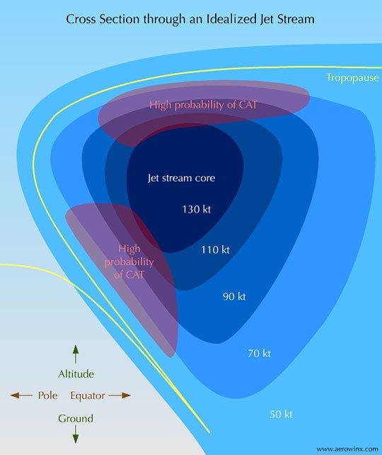
The jetstream exists between 5 and 9 miles up. Even if it is a calm day on the surface the winds above can be over 100 miles per hour. This is like a free boost for airplanes.
The fastest wind I have ever encountered was 164mph. Some of my friends have hit 200+mph over the Atlantic Ocean.
Imagine paddling a canoe in a lake versus a fast-moving river. For the same amount of work, the canoe in the river will be moving much faster because it gets to use the stream of the current in addition to the power from the paddle.
This also hurts performance when flying into the wind, however, it is still beneficial to fly at high altitudes despite a strong headwind.
Those big, billowing clouds that turn into thunderstorms are dangerous to fly through and around. Pilots have to maneuver airplanes away from these. They can go up to an altitude of over 45,000 feet. For smaller, propeller aircraft they usually don’t have an option of going above. They must go around the weather which adds time and expense to the flight.
Once at our cruising altitude I spend a lot of time using the onboard weather radar and coordinating with our dispatcher about upcoming weather to make adjustments early to save time and money. The autopilot can do a lot, but it is up to us pilots to make decisions about avoiding weather and turbulence .
This one is pretty straight-forward. If the plane burns less fuel flying higher up, and it flies faster. Then, it will be able to fly a longer distance. A jet would not be able to cross the Atlantic Ocean if it cruised at only 2,000 feet. High altitude flight has enabled the super long flights we are used to today.
So on nearly all accounts, airplanes like to fly high and fast, it is efficient, smoother, and faster.
In that announcement from the captain, they mentioned the cruising altitude would be 36,000 feet. Cruising? Are there different types of altitudes?
Cruising altitude refers to the planned altitude for the primary duration of flight when the aircraft is at its maximum altitude en route to the destination. After an aircraft takes off it begins to accelerate more and climb up all the way to cruise altitude. Usually the cruising altitude of most commercial airplanes is around 35000 feet, but it can vary between 30000 and 41000 feet as we saw earlier.

This altitude has been carefully planned for the flight by airline dispatchers. They use advanced technology that accounts for wind, distance, weather, the specific airplane performance, and traffic to choose the most efficient cruising altitude.
Pilots may elect to change altitudes because of weather, better wind speed, or if it becomes turbulent. Sometimes changing altitude by just one thousand feet can be the difference between bumpy and smooth.
We have established that most commercial airliners will fly between 30,000 and 41,000 feet. This is the altitude range I have spent most of my hours. On our cockpit displays I can see all the other airplane traffic and their altitudes. Even when we are flying high at 37,000 feet I will still see jets soaring way above us.

Business jets, like Gulfstreams, Dassault Falcons, and Cessna Citations are capable of flying even higher. They regularly have cruising altitudes of 41,000 to 51,000 feet. They can do this because they carry less weight in passengers, and have longer wingspans.
Flying that high is a major advantage. They are above the congested airspace where all the commercial aircraft air. This means more direct routing, often smoother air above the weather, and even more fuel efficiency. But tThere are challenges associated with flying that high up though.
You may be wondering if it is efficient to fly so high up, why not just fly all airplanes as high as they can go? As I’m cruising along at 35,000 feet I wish I could just keep climbing all the way up to space, and pretend I’m an astronaut … but the plane can’t do that.
There is a limit for every aircraft’s altitude capability. It is called the aircraft’s service ceiling. It is based on that airplane’s performance, the weather, and how heavy it is loaded.
On long flights, it is common for an aircraft to start at a lower altitude, and then climb as it burns off fuel, becoming lighter. This is called a step-climb.
The limiting factor for how high airplanes fly is the thin air high up. At very high altitudes there simply is not enough air to sustain lift, and an aircraft would stall, meaning it no longer can produce enough lift to hold the airplane up. This is a dangerous situation to get into, and requires us to be extremely vigilant when flying at high altitudes.
Rockets launch into space by burning a ridiculous amount of fuel and can escape the atmosphere, but airplanes will always be limited by air. The wings need lift and as altitude increases air eventually decreases to nothing.
Because the air is so thin, high up oxygen becomes more important. If a rapid depressurization were to occur there is so little oxygen at high altitudes that without immediately putting on an oxygen mask, we would pass out.
Above 40,000 feet you see in the following table how important it is to immediately have the ability to receive oxygen. We are trained for this procedure. We have special masks in the cockpit that can be donned in under three seconds, and we practice this every year in the simulators.
It is so important that above 41,000 feet one pilot is always required to have their oxygen mask on. In addition, anytime my other pilot leaves the cockpit for a bathroom break I must put on my oxygen mask until they return.
A well-known accident in aviation history involved the professional golfer Payne Stewart. They were flying a Learjet at an altitude of 45,000 feet. The airplane lost pressurization and for some reason, no one was able to get to oxygen. According to the chart, they would have had only 9 seconds or less if it was an explosive decompression.
F-16’s intercepted the jet since it was unresponsive and the F-16 pilots noted the windows were fogged up with condensation indicating a rapid depressurization. Everyone onboard was incapacitated, and a few hours later the airplane ran out of gas and crashed into South Dakota…
Ever since man figured out flying, there has been a competition for who can fly the highest and the fastest. Disregarding flight that is rocket-powered or launched from another airplane, like the X-15 rocket plane, the highest operating aircraft was the SR-71 Blackbird reaching 85,000 feet.
The SR-71 was a long-range, high-speed reconnaissance aircraft. It could cruise at 85,000 feet at speeds over Mach 3.0. This allowed it to use its high-powered cameras to spy on enemy targets while being too high and too fast to be shot down.
While it is reported that the maximum altitude is 85,000 feet there is a lot of secrecy surrounding this aircraft, and some sources say it can climb to over 100,000 feet!
At those altitudes, the pilots need to wear astronaut-like suits because the atmosphere is so hostile and thin their blood would boil without protection. They can see the curvature of the earth!
The SR-71 had its last flight in 1999. Since then the highest-flying plane is another reconnaissance jet. The U-2. It is capable of altitudes around 70,000 feet. Despite being designed in 1955, there are still 30 of these aircraft operational.
The need for high flying aircraft became less as satellite technology increased. High powered cameras on satellites have largely taken the role that aircraft during the Cold War used to provide.
These are maximum altitudes for these jets. These numbers can be replicated only when certain weather conditions and aircraft performance parameters are met.
For most jets it is not uncommon to go to the service ceiling, however, it is more likely to cruise a few thousand feet below this. It is difficult to get an airplane to climb up to their absolute limits. It is usually more advisable and safer to cruise below the maximum altitude.
There are a couple of ways to see the altitude of aircraft. A website called FlightRadar24 tracks airplanes all over the world. If you see an airplane flying overhead, you can open the app, see your location, and see the airplane displayed above you. If you select it you will get information on its route, the type of plane, its speed, and altitude.
Flightaware also has flight information. Before a flight, you can see the filed flight plan and cruising altitude for any commercial flight.
Airlines that have seatback entertainment often have a flight tracker display. It will list the aircraft’s speed, altitude, and some other fun facts about the flight.
Another option is coming up front and asking the pilots before or after the flight. We, as pilots, are always happy to share some of our passion for flying. None of this information is secret, sometimes I have people ask if it is classified. It is all public information and we are happy to tell you!
Take note the next time you hop on a plane. Have a listen to the announcement, or look at a flight tracker. You can see how high you are flying and enjoy seeing cars looking like tiny little dots below you knowing that every part of the flight has been carefully crafted to ensure safety and efficiency.
About the author

Airline Pilot & Flight Instructor - Aviation Professional
Phil McCain is an experienced U.S. airline pilot. He has accumulated over 3500 hours of flight time across the United States, Canada, and Mexico. He is also a flight instructor, industry expert, and passionate traveler. He currently lives in Detroit, Michigan. Outside of the cockpit, Phil loves to read, cook, run, and explore the world around him.
Latest Posts

Can Airplanes Fly Over Hurricanes? And How Dangerous is it?
Read more →

The Least Turbulent Flight Routes

The Most Turbulent Flight Routes
Travel Guides You Can Trust
About Travelness
Brand Assets
Recent Posts
Tours & Activities
Tours in Europe
Digital Security
© 2024 Travelness. All Rights Reserved.
Terms of use - Privacy policy
How do pilots decide how high they fly?

Have you ever watched the moving map on a flight? If so, you'll have observed that the height at which you fly changes from flight to flight. If you're super observant, you may have noticed that on longer journeys, this height changes a few times during the flight. But what dictates how high you fly? And why does this often change during the flight?
Height, Altitude and Flight Level
First, let's differentiate between some technical terms. Two of which you will have heard of, the other, you may not have. Even though height and altitude are easily interchangeable in common language, there's actually quite a difference between the two in the aviation world.
Height refers to the vertical distance of an object above the ground. The structure of the Air Traffic Control tower at Heathrow Airport has a height of 285 feet. This means that the distance an object would fall if you were to drop it off the top would be 285 feet. Pretty obvious.
Altitude refers to the vertical distance of an object above sea level. The important factor here is that this is very much dependent on the air pressure. As weather systems move around the world, the pressure of the air changes above a certain location on the ground. These pressure changes are like the air in an inflatable mattress. Imagine placing a model aircraft on top of your mattress and treat the floor as sea level. As you pump air into the mattress, increasing the air pressure, the aircraft rises higher than the sea. When you let air out, lowering the pressure, the aircraft sinks closer to the sea.
As a result, pilots have to be aware of the air pressure for their location in the world. To make sure they are flying the correct altitude, they have to update their altimeter accordingly.
If you're thinking that there still seems to be no difference between the two, you're forgiven. Hopefully the next bit will clear it up.
Terrain Clearance Is Key
Say you're flying over the sea at 3,000 feet altitude on the local pressure setting. Because you're over the sea, this also means that your height is 3,000 feet. So there's a lovely safe distance between you and the water. Pilots like air between them and the surface. But what happens when you reach land fall and fly toward some hills?
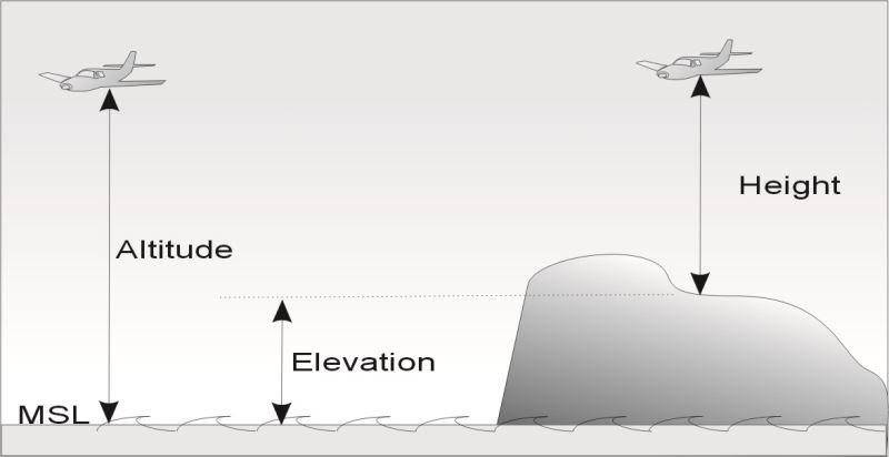
Assuming the air pressure stays the same, you're still flying at 3,000 feet altitude, but as the ground starts to rise underneath you, your height is now decreasing. If I was to tell you that the tops of hills and mountains are measured in elevation — the vertical distance above sea level — you'll understand why altitude is of far more use to pilots than height. When flying close to the ground, terrain clearance is key. If we know the elevation of the terrain below us, by ensuring we have the correct pressure set, we can ensure that we keep a safe distance between us and the terrain.
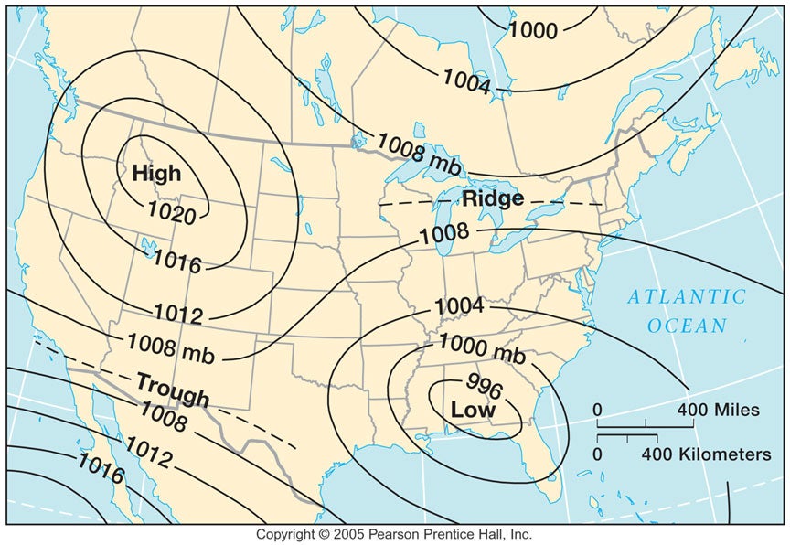
Looking at the chart below, you'll notice that for a flight from New York to San Francisco, the air pressure changes regularly. Constantly changing this for five hours would be tedious. Also, if one aircraft forgot to keep theirs updated, a loss of separation could occur. As a result, once above a certain altitude, pilots set a standard pressure setting, 1,013 Hectopascal's (the unit of pressure measurement) and fly at Flight Levels.
By flying at a Flight Level (FL), aircraft can fly for thousands of miles without having to reset their pressure setting. When climbing away from an airfield, ATC will instruct the pilots to climb to a certain Flight Level. Take the last two 0's from the altitude and you have the FL — i.e. 23,000 feet becomes FL230. The pilots will change the pressure setting to 1,013 HPA and the aircraft is now flying at a Flight Level. When approaching the destination airfield, ATC will instruct them to set the local pressure setting, the QNH, and from then on, they are flying at altitudes.
How High Can We Go?
Now that we've cleared up the differences between altitudes and Flight Level, we can start to think about why aircraft fly at certain levels and why this varies from flight to flight. First of all, let's look at the aircraft itself.
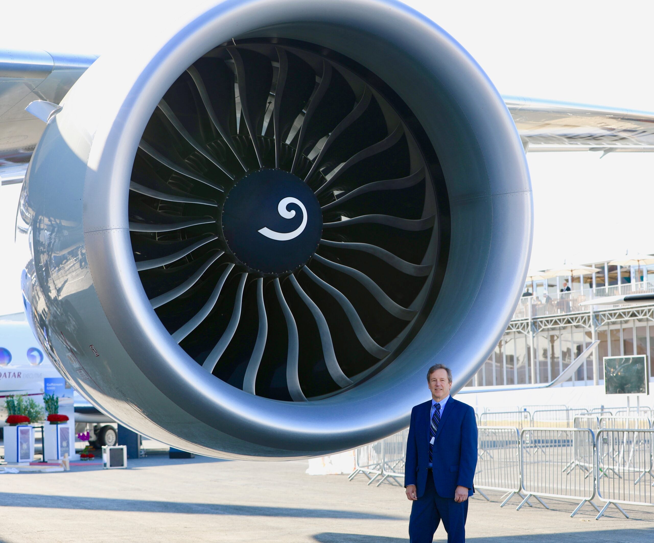
The engines on a modern jet aircraft are a phenomenal pieces of kit. The GE90-115B, which powers the Boeing 777-300, is so big that I could stand in the engine and not be able to touch the top. The way in which they are designed means that the higher they fly, the more efficient they become. This means that pilots will normally fly as high as possible to minimize their fuel usage.
However, if you read my previous article on turbulence , you'll have learnt that the lift that makes us fly is generated by the wings, not the engines. Basically, the wing relies on air molecules passing over the surface to create lift. This is all well and good at sea level, where the air is nice and thick, but as you go up in the atmosphere, it starts to thin. The higher you go, the fewer molecules there are per cubic foot of air, resulting in less lift.
This produces an interesting tradeoff. The engine wants to be as high as possible. But try to go too high and the wing may not be able to generate the lift required to reach that altitude. As a result, there will be an optimum altitude for the aircraft to fly. This level maximizes the engine efficiency but also allows the wing to provide enough lift to fly safely. This is the basic principle of level selection.
So how do you increase the lift available so that the engine can operate in the more efficient higher air?
Going back to the vary basics, an aircraft flies because thrust drives it forwards, overcoming the drag . When the lift is greater than the weight , it takes to the sky and flies. From this diagram you can see that the lift competes directly with the weight . So if you want to increase the lift, you have to decrease the weight.
Now, you could open the doors and start throwing chairs and food carts out to reduce the weight. However, passengers don't tend to like it when they have nothing to sit on and pilots don't like it when they have no tea to drink. There is a more obvious way to lose weight.
In my previous article on fuel , I explained that a long-haul aircraft may take off with around 70 tons of fuel in its tanks. When the flight takes off, there is an optimum altitude at which the aircraft will fly for its weight. As the flight progresses, fuel is burned by the engines, which reduces the weight of the aircraft. As the fuel on board reduces, the lift available becomes greater than the weight, so the aircraft is able to climb to altitudes where the engines are more efficient. This is why on a long flight you may start at 35,000 feet, a few hours later climb to 37,000 feet and then some hours later climb to 39,000 feet.
Higher Isn't Always Better
As with all things aviation, things are't always that simple. There are other external factors that affect how high we fly. First up, wind.
As a general principle, wind flows around the globe from west to east. This is why it takes longer to fly from London to New York than the other way around. At times, these winds can be so strong that they can have a major effect on the flight time. In an upcoming article, I'll be talking more about jet streams. However, for now, let's just say that they are areas of fast-moving winds.
If an aircraft can utilize these strong winds, it can cut considerable time off the flight time. The only problem is that these jet streams tend to be at a lower altitude than the engines are most efficient. Once again, there's a tradeoff to be made.
All airlines have a flight-planning department, which studies the weather patterns to plan the most efficient route for a flight. If the winds are so strong at a lower level, it may mean that the saving in-flight time outweighs the reduced engine efficiency. So, even though the aircraft could fly higher, it will fly at a lower altitude to take advantage of the strong winds. This is particularly common on overnight flights from the USA to Europe.
Having read my article on turbulence , you'll know that it's often caused by variations in the wind. The jet streams mentioned above are great if you're in the fast moving core, as conditions tend to be nice and smooth. But if you're flying in an area between the slow moving out air and the fast moving core, things can get bumpy. As a result, we like to fly at levels that either keep us in the core of the jet stream or nicely outside it.
The above is all well and good if you're the only aircraft in the sky, but in today's busy airspace, separation from other traffic has a bigger impact on how high we fly.
The skies above your head are more complex than you could ever imagine. Look up on a clear day and you'll see aircraft seemingly making their own way across the sky. In fact, every movement — both laterally and vertically — is planned and coordinated with extreme precision. Very much like motorways in the sky.
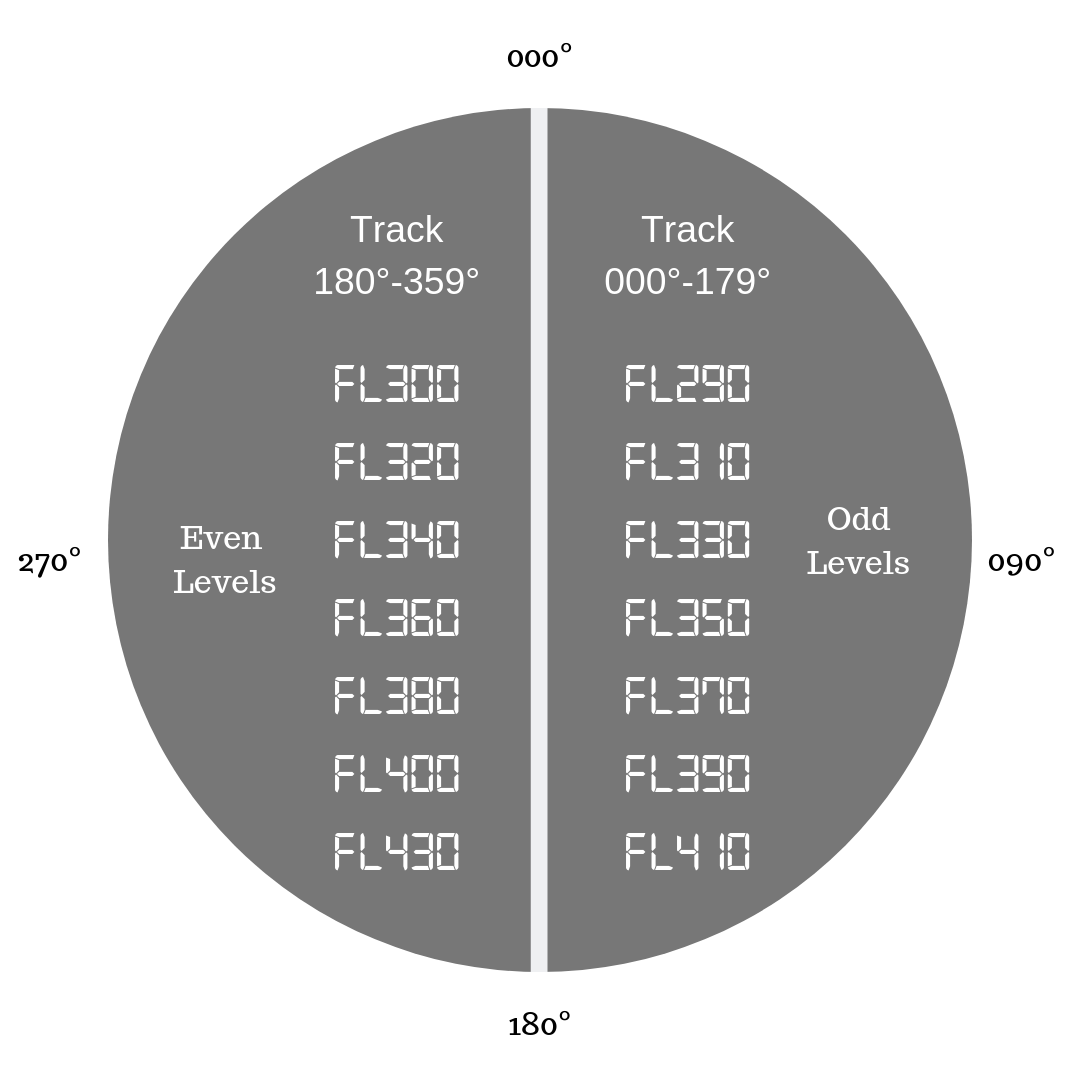
These motorways follow a basic principle called the semicircular rule. Aircraft are always separated by a minimum of 1,000 feet vertically. When flying eastbound, a track across the ground of 000° to 179°, aircraft fly at odd levels. Westbound aircraft, a track of 180° to 359°, fly at even levels. Using this rule, ATC ensures that aircraft flying toward each other don't end up at the same level.
Before we get airborne, a flight plan is submitted to ATC to inform them what level we plan to fly at. This enables them to plan and coordinate all the traffic coming their way. When we get airborne, we fine tune this level request based on our actual weight and pass this to ATC over the radio. They then do their best to accommodate our exact request.
For an example, take a flight from London to Boston. Due to the structure of the traffic system over the Atlantic, there are only limited lanes of this motorway available. The only way to get more aircraft into these lanes is to put them at different levels.
As a result, due to high demand at certain times of day, the level which we would ideally prefer may not be available. We may have to take a different level, which could impact our fuel usage, as explained in my article on fuel.
Bottom Line
Aircraft don't end up at their altitude by mistake. A number of decisions have been made by flight planners, ATC and pilots to ensure that your aircraft is flying at its optimum altitude. So next time you feel your aircraft start to climb or descend during a flight, you'll know that it's done to make sure that your journey is as safe and comfortable as possible.
You are here
Altitude, flight level and height.

Definitions
The vertical distance of an object measured from mean sea level.
Flight Level (FL)
A surface of constant atmosphere pressure which is related to a specific pressure datum, 1013.2hPa, and is separated from other such surfaces by specific pressure intervals.
Altitude above sea-level in 100 feet units measured according to a standard atmosphere. Strictly speaking a flight level is an indication of pressure, not of altitude. Only above the transition level (which depends on the local QNH but is typically 4000 feet above sea level) are flight levels used to indicate altitude; below the transition level feet are used.
e.g. FL250 = 25,000 feet above mean sea level when the pressure at sea level is 1013.2 mb.
Elevation or Height
The vertical distance of a level, a point, or an object considered as a point, measured from a specified datum.
Units of Measurement
The primary unit of measurement of altitude and elevation or height is the metre. However, the most widely used unit of measurement in aviation is the foot. Metric altitudes and flight levels are used in certain countries. ICAO Annex 5 and Supplement give a partial listing of the units of measurement used in most countries. If any doubt exists, the Aeronautical Information Publication (AIP) of the country in question should be consulted.
Related Articles
- International Standard Atmosphere (ISA)
SKYbrary Partners:
Safety knowledge contributed by:
Join SKYbrary
If you wish to contribute or participate in the discussions about articles you are invited to join SKYbrary as a registered user
Message to the Editor
About SKYbrary
What is SKYbrary
Copyright © SKYbrary Aviation Safety, 2021-2024. All rights reserved.
- Which Layer Of The Atmosphere Do Airplanes Fly In?

Aircrafts typically fly at higher altitudes because air gets thinner as planes ascend higher into the sky, translating in less drag. That means at higher altitudes planes can fly faster and use considerably less fuel. The "preferred region” in the airline industry usually begins at 35,000 feet and ends at 42,000 feet. Operating at very high altitudes means that the amount of oxygen becomes very low for proper combustion in the engines. Traveling at low altitudes, on the other hand, means that the plane is met by higher air resistance. It is essential to note that particular models of aircraft have various optimal altitudes in which they fly. For example, the Concorde was known at heights of between 50,000 and 60,000 feet, and a region where commercial planes regularly do not fly.
Troposphere and Stratosphere
Traveling at high altitudes also means that airplanes can avoid bad weather that is typically found in the lower regions of the atmosphere . It is not uncommon to see bluebird sky from the window seat and later descend to the airport to find different weather conditions. The majority of weather phenomenon on the planet occurs in the troposphere, which is the lowest layer of the atmosphere. It extends up to about 36,000 feet. Helicopters and light aircraft typically fly in the troposphere. Light aircrafts are unable to operate at higher altitudes because they lack pressurized cabins. Therefore, they stay within a range of about 10,000 feet. Flying to higher altitudes would require pilots to wear functional oxygen masks to avoid losing consciousness. Commercial aircraft typically prefer to travel in the stratosphere which has less turbulence and air traffic. Flying in the stratosphere also means that pilots have more time to handle the difficult situation compared to those flying at lower altitudes.
Laws of safe flying altitudes
Around the world, numerous regulations govern low safe altitudes in which aircraft can travel. The laws mainly apply to light aircraft as opposed to airliners. Generally, it is considered unlawful to fly below 1,000 feet in an area with buildings and 500 feet above any vehicle, person, or structure. Such laws ensure the safety of aircraft, people, and property on the ground. The regulations are also put in place due to environmental concerns. Pilots have to ensure that their aircraft is high enough to allow them to clear a congested area when the airplane experiences engine failure. The regulations, however, do not affect take-offs and landings as governed by flight paths. Pilots are also advised against flying too high as engines may struggle due to low oxygen levels at extremely high altitudes.
- World Facts
More in World Facts

The Largest Countries In Asia By Area

The World's Oldest Civilizations

Is England Part of Europe?

Olympic Games History

Southeast Asian Countries

How Many Countries Are There In Oceania?

Is Australia A Country Or A Continent?

Is Turkey In Europe Or Asia?
Fact check: False claim planes flying ‘straight and level’ prove the Earth is flat

The claim: Planes flying ‘straight and level’ prove the Earth is flat
One of the first things aspiring pilots learn is straight-and-level flight , a technique that involves maintaining control of a plane while staying at the same altitude and flying in one direction.
A recent Facebook post, though, claims straight-and-level flight supports the long-debunked theory that the Earth is flat .
“Airplanes will fly for hours at the same altitude, never dipping their nose down to follow the curve of the Earth,” says the narrator of a video in the Oct. 6 post .
The same claim appeared in an Instagram post that accumulated more than 3,000 likes before it was deleted.
The narrator describes a hypothetical flight from Portland, Oregon, to Seoul, South Korea, claiming such a trip would require a plane to fly “so far around the Earth that it’s flying downwards, with its nose vertically downwards" and “around the curve of the Earth so that the airplane is now flying upside down.”
“It would have to make that kind of flight path on a globe, which is such an absurdity,” the narrator says.
But this line of thinking is nonsense. Straight-and-level flight doesn't refer to a literal straight line through the air. Instead, it's based on keeping a consistent altitude and direction.
The situation described in the video would not result in a plane flying “upside down” because Earth does not have a top or bottom . The force of gravity pulls everything on the planet toward the center, regardless of how the planet is aligned from a viewer’s perspective in space.
USA TODAY reached out to the social media users who shared the post for comment.
Follow us on Facebook! Like our page to get updates throughout the day on our latest debunks
Pilots constantly make adjustments to maintain speed, altitude
Pilots are constantly making adjustments to maintain their speed and altitude, said Greg Feith , a National Association of Flight Instructors board member and former National Transportation Safety Board accident investigator.
"This is the way aircraft maintain a constant pressure altitude and speed," Feith said. "It is by this mechanism that aircraft follow the curvature of the earth without intervention of the pilots."
Altitude can be measured using air pressure , giving pilots a consistent measurement regardless of the specific topography at ground level.
"Pressure altitude is very predictable and constant," Feith said. "The only thing that changes is the aircraft's height above ground level because the terrain geography changes."
Flight maps often show planes traveling in an arc , but that's because Earth is three-dimensional, and maps are two-dimensional. A straight line between two locations on a globe becomes an arc when flattened on a map.
USA TODAY has debunked an array of false claims about the flat Earth theory, including that a compass wouldn't work if Earth is spherical , that clouds appearing to go behind the sun prove the Earth is flat and that a video showed a NASA astronaut being filmed in front of a green screen .
Lead Stories also debunked the claim .
Our rating: False
Based on our research, we rate FALSE the claim that planes flying "straight and level" prove the Earth is flat. That concept doesn't mean planes are flying in a literal straight line. It's a technique that involves flying at a consistent altitude in the same direction. Pilots constantly have to make adjustments to maintain speed and altitude. A plane flying from one location to another would never end up upside down because the Earth does not have an inherent top or bottom.
Our fact-check sources:
- Greg Feith , Oct. 28, Email exchange with USA TODAY
- Gleim Aviation, accessed Oct. 28, The Basics Of Straight-And-Level And Slow Flight
- One Monroe Aerospace, Aug. 20, 2018, Why Do Airplanes Travel in an Arc?
- Scientific American, March 27, 2020, Flat Earthers: What They Believe and Why
- University College London, accessed Oct. 28, Why don't we fall off the Earth at the south pole?
- National Geographic, accessed Oct. 28, Altitude
- USA TODAY, Feb. 22, Fact check: A compass is oriented to the Earth's magnetic field lines, doesn't prove flat earth
- USA TODAY, Jan. 23, Fact check: Clouds can appear behind the sun in photos due to optical illusion
- USA TODAY, Sept. 23, Fact check: False claim that video shows NASA astronaut Karen Nyberg in front of green screen
- Lead Stories, Oct. 25, Fact Check: Airplanes Do NOT Fly 'Straight and Level' -- Earth Is NOT Flat
Thank you for supporting our journalism. You can subscribe to our print edition, ad-free app or electronic newspaper replica here.
Our fact-check work is supported in part by a grant from Facebook.
Why Are Great Circles the Shortest Flight Path?

Why do you fly over Greenland in an airplane flight?
Or why is it that when you see flight paths on a map they always take a curved route between 2 cities?
It’s because planes travel along the shortest route in a 3-dimensional space.
This route is called a geodesic or great circle route . They are common in navigation, sailing, and aviation.
But geodesics can be confusing when you’re looking at a 2-dimensional map as they follow quite the odd flight path. Let’s dig into this concept a bit deeper.
Great Circle Routes Explained
In a flight path from New York to Madrid, if I asked you which line is shorter, you’d say the straight one, right?

However, a straight line in a 2-dimensional map is not the same as a straight line on a 3-dimensional globe .
This is why flight paths travel along an arc between an origin and a destination.
Now here’s what the same flight paths look like on a sphere. Remember that the straight line in the Mercator map above followed the 40° latitude line.

This paints quite a different story, doesn’t it? It’s deceiving to the human eye.
The takeaway is this:
A route that looks longer on the map is because of the distortion created by map projections like the Mercator Projection . In navigation, pilots often use great circles (geodesic) as the shortest distance flight.
Great circles vs small circles
Now that you have a visual understanding of great circles. Here’s a definition of what a great circle is:
- A great circle is a circle on the globe such that the plane passing through the sphere’s center is equal to the circumference of the Earth.
- Alternatively, a great circle is where the radius is equal to that of the globe representing the shortest distance between two points on the surface of the earth.
In basic terms, imagine you’re cutting into an orange. You can cut them at any angle – north-south, east-west, diagonally. As long as you cut two identical portions, then the circle where the cut was made is a great circle.
For example, the equator is a great circle because it’s the maximum possible circle:

You could also cut it at the north and south poles. This longitudinal line also cuts two equal portions. Any meridian line is a great circle as well.

From New York to Madrid, here’s how the plane creates two equal segments.
A great circle generates two arcs with the shorter one being the shortest path. Here is the shortest path and how the plane is angled to create the shortest path.

How about when you follow along the 40° latitude line? Anywhere that it doesn’t cut two equal pieces is a small circle .
While a rhumb line track is at a constant azimuth, a geodesic line changes direction all the time.

This fundamental difference in navigation concepts can have a significant impact on long-distance sea voyages.
READ MORE : Rhumb Lines: Setting it Straight with Loxodromes
How Geodesics Work
Planes travel along the shortest route in 3-dimensional space. This route is called a geodesic or great circle .
While map projections distort these routes confusing passengers, the great circle path is the shortest path between two far locations.
This is why pilots fly polar routes saving time and distance . And this is why pilots often fly over Greenland.
Have any questions? Please let us know in the comments section below.

25 Map Types for Building Unbeatable Maps

Epic Web Maps – The Maps Hall of Fame

50 Map Projections Types: A Visual Guide

How Map Projections Work

Esri JavaScript API Examples: 15 High-Tech Webmaps and Webscenes

Ocean Currents Map: Visualize Our Oceans Movement

3 Wildfire Maps for Tracking Real-Time Forest Fires

10 Topographic Maps From Around the World
35 comments.
Buy a globe and figure it out.
I’m trying to figure out what flight path an LTA aircraft (Larger than Goodyear Blimp) would take from England to Idaho. It’s part of a novel I’m writing. Any suggestions?
You’re definitely on the right path and to use a great circle.
I am a layman. Please describe the route from Mumbai to New York and San Fransico to Tokyo through a diagram to show why airlines prefer polar routes?
A great circle connecting two points is the shortest distance but it requires frequent heading changes throughout the journey. A straight line (rhumb line) drawn on a Mercator projection map produces the constant compass bearing to follow for the same journey; which is easy to draw and much easier to follow. Over a short distance the difference between a great circle and a rhumb line route is negligible so the simple rhumb line route is used. However, over a very long journey the difference in distance will be quite significant so a great circle route is preferred.
In navigation latitude is the angle above (north) or below (south) of the equator. Longitude is the angle east or west of the prime meridian (ie the Greenwich Meridian). Both of these angular measurements are derived from the centre of the global earth mass. 0 degrees latitude, 0 degrees longitude is the intersection of the prime meridian and the equator (just south of Ghana West Africa).
When you try to draw a flat map to depict the surface of a globe there is a huge problem; imagine taking the peel off of an orange and trying to lay it out flat.
On the surface of global earth the horizontal distance measured between two meridians along the equator (0 degrees latitude) will be greater than the distance between the same two meridians measured along any other latitude because the circumference of each latitude gets smaller toward the poles so the meridians are closer together near the poles. However, the distance measured between two latitudes on the same longitude is the same distance on other longitudes because they will lie on a great circle.
For marine navigation the map solution generally accepted is the Mercator projection because of its unique property of representing any course of constant bearing as a straight segment that can easily be drawn on a flat map. Such a course, known as a rhumb line, is preferred in marine navigation because it is easier for a ship to sail in a constant compass direction to reach its destination even though it will be a bit further than a great circle route. For short distances the difference between the rhumb line and great circle route is negligible. For aviation the distance is more critical since it directly affects time, fuel and load. A simple solution is, where possible, create a sequence of short rhumb lines along the corresponding great circle route. In the modern era all of these positioning problems have been overcome by GPS satellite navigation.
These days we all take degrees latitude and degrees longitude for granted because they have been successfully used for over 2,000 years. Around that time there were early attempts to measure the circumference of the global earth. Early mariners setting off on long voyages either came ‘back’ or never returned; which for millenniums gave rise to the flat earth notion. The first circumnavigation of the earth was accomplished by the Magellan fleet sailing westward 500 years ago. I’ve personally used latitude and longitude to circumnavigate the earth 5 times.
I’ll finish with a reminder that latitude and longitude are both angular measurements derived from the centre of the global earth mass. If the earth were flat then for positioning on it there would be only one angle from the centre and a linear distance measurement from it… an idea that has never ever been tried and proven.
Taking all of the info from this page into consideration, how could it be used to strengthen flat earth theory? I was directed here because I wanted to learn what constitutes a “great circle” and I now understand. I seriously want to know how anyone could reach that conclusion.
High-altitude flying brings another problem to the fore. It is called “coffin corner” where if you fly slower you will stall, and if you fly faster you will also stall.
It actually makes sense if you go back to the comparison of cutting an orange. Again understanding how to navigate along a 3-dimensional globe while looking at a 2-dimensional picture is why it seems so confusing. And No Cari it doesn’t support the flat earth theory. Not even its own theory supports it. lol. The entire point of this is because of it’s a globe. If it were flat none of this would be necessary. Not to mention the Japanese would still be en route to Pearl Harbor if it were a flat earth. That’s an exaggeration but still, it would have been quite a long flight. One that those little planes would never have been capable of making. In fact, if the earth were flat many lives at Pearl Harbour as well as at both Hiroshima and Nagasaki would have been spared. It’s a shame that the earth is in fact round.
You have supported the theory of a flat earth. Thanks.
My wife just left Dallas for Tokyo. I looked on the flight plan and it goes up through Montana and Canada and over the edge of Alaska. I don’t see how this could be the shortest route to Tokyo from Dallas. It seems more like they are trying to avoid flying directly over the vastness of the Pacific Ocean in case there is a mechanical problem.
Having read all the above I’ve decided to go by boat.
Odd! I was told that because of centrifugal force, the Earth was compressed at the poles, thus making it wider at the equator. The great arc is a navigational compensation!
Meanwhile, the Egyptians, who started all this, still could not figure out the height of the pyramids even though they had Pythagoras. Not to mention that even today there is no certain way to measure the partial volume of a cylinder.
The Earth is flat and south polar centered. That’s it.
What about the direction of the route? Nobody can convince me that Madrid lies to the north of Newyork as they are saying now.
Maybe thats how they conclude it but its wrong, even if it works. the real reason is because of difference of rotational velocity of a shorter vs longer circumference. if you draw two lines from the center of a circle, each come out of the destinations. then draw two lines, one at altitude and the other at ground level. clearly the one at altitude is longer. it doesn’t matter if these lines are curved or not. what matters is the velocity the earth rotates at. the length of a circumference increases by 2 pi r. this means that at greater radius per starting location, the rotational velocity of a shorter radius vs a larger are varied. at a great altitude, though you are traveling at a perceived pace relative to the motor function, but you are multiplying that velocity by the increase in circumference relative to the ground’s. or vice versa, you can say the ground it traveling quicker as well since two point in the circumference have less distance to travel compared to the greater altitude. but what this really does is multiply the distance you travel at altitude relative to the ground. so one minute of flight at ground level vs one minute of flight at altitude results in greater distance. but its only if you fly against earth’s rotation. the earth is rotating at a constant speed, but the circumference between the greater height points travels at length over time just as the shorter one. but the shorter circumference then has less length to travel in that time, so its technically traveling slower. so as you increase height from the center of a circle, the increase in circumference, with earth’s rotation increase your velocity. if earth wasn’t rotating, then height wouldn’t matter and straight line would. 3 dimensions or 2… sure, you could look at it that way, but its over complicated…
Because the time it takes to fly to the higher altitude is not commensurate to the time lost by not climbing.
Let P = pressure, d = density, R = gas constant, T = temperature, h = height, g = gravitational acceleration.
By Ideal Gas Law PV = nRT -> d = n/V = P/RT
By the law of hydrostatic pressure
dP/dh = -d*g = P*g/RT
We know have a first-order separable differential equation. Solving this, we get:
Integral dP/P = Integral -g/RT dh log(P) – log(P0) = -g*h/RT -> P = P0*exp(-g*h/RT) d = P/RT = P0/RT*exp(-g*h/RT)
Therefore, as you go higher, the weight of the air column decreases reducing atmospheric pressure and density. However, the air also gets colder slightly increasing density. In the Stratosphere, temperatures increase with altitude instead of decrease. However, this layer of the atmosphere is above the troposphere where we live, so it has to be less dense. Thus, the weight of the hydrostatic pressure of the air column has a larger effect on atmospheric pressure and air density at least less than 10 km above sea level.
In the real world of long distance air navigation, great circle routes are *not* the shortest *flight* path, but they do make a good start on figuring out what will be the shortest flight path. The article fails to understand that aeroplanes travel in the air, which is moving, rather than fixed in relation to the earth. The origin and destination are fixed to the earth, if the sea and the air were likewise fixed, a great circle would yield the shortest path. A longer path with regard to the earth can yield flight path savings in the order of 30% to 50%, the classic example being North Atlantic flights in the forties, where savings of this order resulted from using Bellamy drift derived constant heading paths instead of great circle routing.
Aircraft need to travel the shortest route in the air, not in three dimensional space. Sometimes that will be the same thing, but not very often. For an air routing, you could use the barometric pressure at origin and destination plus the latitudes. Using these, you can calculate the drift for the entire flight due to pressure differences and Coriolis effect, the net geostophic winds. However, there may be jetstreams at less optimum altitudes that could provide considerable net improvement, even if more fuel is used per air mile (meaning movement through the body of air, not the 3D relationship with the earth), but lets not go there. Having derived a constant heading, it is flown, and neglecting political geography, with no concern for the position with respect to the position on earth below, other than the destination and not bumping into things.
To help with the lay understanding, imagine a rectangular table top, with a dot at each end. Over the top you have a much larger piece of perspex. You have a toy car which can travel at a speed equal to the distance between the dots over one hour. Over the course of an hour, the perspex moves half that distance to the left of the direct track, then half that distance to the right. If we attempt to stay on the “shortest” path from A to B, at the end of an hour, we will still be at A. If we calculate the net drift between A and B, which in this example means following a constant heading equal to the direct heading at the start of the journey, our path will be much longer than the direct path, a loop heading out to the left. However, after an hour, we will be at B. If we change the total distance moved by the perspex to half A-B, purely left and right, it will still take us one hour on the constant heading, but if we follow the direct path on the table top, we will get there, having taken considerably more than an hour to do so.
On shorter journeys in the real world, there are few wind reversals – there is also little difference between a rhumb line course and a great circle, so you may as well fly a rhumb line. Longer journeys are where this counts, and also where the great circle should be of use, but often is not, due to winds aloft.
The correct term is “Density altitude” which is a calculation of pressure altitude corrected for nonstandard temperature. As temperature and altitude increase, air density decreases. All aircraft have a flight “ceiling”, an altitude above which it cannot fly. As an airplane ascends, a point is eventually reached where there just isn’t enough air mass to generate enough lift to overcome the airplane’s weight. This is why (depending on the airplane) you might not be able to take-off from a high altitude airport on a particularly hot day. I have experienced this (pilot) myself several times.
If you depart from the North Pole with a plane along a meridian, directly from the rotation point (rotation axis) where speed is 0, to a destination at the equator where the rotation speed is around 1660 km / h , would the plane still reach its destination? From North Pole direct to Brazil(circular arc over meridian 60 W).
Thinner air does not give better engine performance. The reason flying high is more economical compared to flying at low altitude is because the TAS is higher due to density. Thus the amount of fuel burned per nm travel is lower.
You have such great figures. May I use one of them in a presentation to illustrate great circle routes?
Yes, you can. But please give credit by referencing to gisgeography.com
Chris, you are wrong. For air, D=PM/(RT), where D=mass density, P=pressure, M=molecular weight average, R=ideal gas constant, & T=absolute temperature. This is why you need to fill your tires with air in the winter. The temperature drop compresses the air, which means you have to add air to fill in the same amount of relative space.
There are many other atmospheric factors in play such as humidity, wind speed, and wind direction to consider as well.
…and yes, thinner colder air is better for fuel efficiency, but bad for lift. The higher you go, the harder it is to maintain altitude, so like everything else, there is a trade-off. Airplanes are designed to take advatange of the thickness of the air at a certain altitude. That altitude is not fixed relative to the ground, but depends on the weather. So on a hot day, they can fly higher. On a cold day, they.have to fly lower. But there is always an optimum “temperature altitude” for any given plane on any given day. You can’t just keep going up forever. You need pressure under the wings, or you’re flying a brick.
Airplanes need air pressure to fly, it doesn’t matter how dense the air is if there’s no pressure, and pressure and altitude have a consistent relationship. Does that make sense?
Actually, you’re all right, but you’ve each only got two-thirds of the puzzle. There is no direct relationship between temperature and density. There IS a relationship between PRESSURE and temperature and density.
In aviation, there is a concept called “termperature altitude.” So the actual relationship is between all three of them, but the focus is only on the two. The higher you go, the colder and thinner the air gets because the pressure is dropping. For every 1000 feet you go up, there is an expected drop in temperature and pressure, and this remains constant. So flying through colder air is like flying higher. The colder air makes the pressure go down while the density remains the same. The airplane acts as if the air is less dense. Got it?
I too, like Mr. Bir, noticed that there was something wrong with the explanation regarding the density of air. Yes, as air gets colder it gets denser, that’s why to start a cold gasoline engine you have to activate the ‘choke’ which in turn will supply the fuel-air mixture with an extra amount of fuel in order to compensate the leanness that otherwise would not start a combustion.
J Bir, unlike liquids the viscosity of gases inceases with increasing temperature. This can be explained using the kinetic theory of gases.
Mr Bir has it right on, as soon as I read it, I questioned it. But we appreciate your explanation of the great circle route. Good article.
Let me correct you. As the air gets colder, it gets denser, not thinner. However, as you increase in altitude, the air gets thinner and colder. Pilots will always want to fly higher as the low density of the air reduces drag and thus increases the efficiency of the fuel.
Every airline in the world has a business route. This route determines where the aircraft can and cannot fly. For example certain routes over the Atlantic are more costly to make but much faster, the final determination is down to the pilot, in regards to how much fuel he has on board, how delayed the aircraft is, in respect to flying faster than he normally would. This is a very significant thing when determining which transatlantic route to take, because there are at least a dozen of which only 3 of those routes are the fastest and most economical, the rest vary with flight cost. In respect to flying over Greenland, there was a very valid reason to do so especially during the winter and early spring months. As the air gets colder, it gets thinner, and the air thins it gets more and more difficult for an aircraft to stay in the sky. This meant under aviation rules, those aircraft with only 2 Jet Engines had to make the shortest distance between land masses, incase an engine stopped working. This way the pilot could make an emergency landing. Aircraft such as the 747 had no such problems, and could easily fly the quickest transatlantic routes. However over the decades Jet Engines have become increasingly reliable, so much so, that they too can now fly over the Arctic to whatever destination. There are very few airlines who actually use Arctic routes, because these routes are extremely expensive to use. An example of a flight from Helsinki (EHFK; HEL) to Barcelona (LEBL, BCN) does not use a Great Circle nor a Small circle, it uses a direct path from point A to B.
Small circles are not always used for short distances, infact they are seldom used in Europe. Instead most short distances are literally from A->B.
Why are small circles used in short distance trips and not the latter?
Leave a Reply Cancel reply
Your email address will not be published. Required fields are marked *
Simple Flying
The long way round why flight paths are curved.
Have you ever wondered why flight paths on flyers and maps appear curved?
Have you ever wondered why flight paths on flyers and maps appear curved? Although this may be debated by a minority, the reason is pretty straightforward - the earth is not flat. It is a sphere, and when the routes over a globe are projected on a flat piece of paper in 2D, certain inaccuracies occur.Meanwhile, flights from Europe to East Asia and vice versa have now given cause to a different kind of curved path - the one circumventing Russian airspace . Of course, flight paths shifting due to geopolitical reasons is nothing new, as anyone following a Qatar Airways flight to or from Doha during the years of the neighborhood blockade will know.Let's take a closer look at the curvature of "regular" flight paths and what influences them, and some examples of conflict-induced deviation routes .
Great Circles, Latitudes, and Longitudes
To understand flight paths, we need to run over some geography, so bear with us. A great circle is a circle on the surface of the earth, the center and radius of which are those of the earth itself. The great circle is an important part of navigation because the shortest distance between two points on the earth’s surface is the shortest arc of a great circle, joining the two points. The Equator is a great circle. It runs from East to West and divides the earth into two hemispheres.
The earth also consists of Meridians and Parallels of Latitude. The meridians are semi-great circles that join North and South, while the parallels of latitude are small circles whose planes are parallel to the Equator. There is also a Prime Meridian. This is the benchmark for defining longitude. It passes through the Royal Observatory in Greenwich, UK. For this reason, it is also known as Greenwich Meridian.
Looking at the latitudes and longitudes, the latitude of any point is the angular distance measured along the meridian through the point from the Equator to the point. A longitude of any point is the shorter distance in the arc along the Equator between the Prime Meridian and the meridian through the point.
Both the latitude and longitude are measured in degrees and minutes. The latitude and longitudes are mostly expressed as coordinates, where the latitude represents the North-South coordinates, and the longitude represents the East-West coordinates.
Mercator projections and rhumb lines
In the early days, to generate a map, a scale model of the earth was wrapped around a cylinder of paper with the scale at the Equator. A light source was then shined through the model. The cylinder was then developed to produce a flat map.
Flat maps were great for early sailors and navigators because, with a straight line drawn on the map from position A to B, one just had to measure a single bearing. This bearing remains constant throughout the route, which makes navigation simpler and easier. Such a straight line on a flat map is known as a rhumb line. A rhumb line is a line that cuts all the meridians at the same angle.
In the 16th century, a navigator named Gerhard Kremer realized that the flat maps that were being used stretched in the North-South direction. He found out that when projected as mentioned above, the scales for the North-South and East-West were different. He figured out that the North-South scale was proportional to tangent (tan) latitude and the East-West scale was proportional to secant (1/cos) latitude. So, what he did was simple - he adjusted the positions of the parallels of latitude so that they had a scale proportional to the secant of latitude, matching the East-West scale.
During the explanation of great circles, it was said that a great circle gives the shortest route on a sphere. Thus, a rhumb line flown using a flat map gives a longer route which is not the most efficient way to travel . The easiest way to imagine a great circle route is to imagine placing a piece of string on a spherical object. The string represents great circles.
Earth convergency
As discussed in the previous paragraph, with a flat map, one could follow a single track to the destination. This was of great benefit when humans used to travel with a simpler navigation system such as a compass.
However, as the earth is a sphere, the application of using a chart that represents the earth as flat does not give the best outcome. The meridians on the earth, as one moves from the Equator, converge, and this makes the great circle route change its track at every passing meridian.
Convergency is the angle of inclination between two selected meridians measured at a given latitude. At the Equator, the convergency is zero as there is no inclination of meridians. At the poles, the convergency is at its maximum. This gives a sine latitude relationship. The equation for convergency is given below:
Convergency = Change in Longitude x Sine Mean Latitude
Here is an example:
The aircraft is flying from 36N 015E to 42N 007E. The mean latitude, in this case, is 39N, and the change in longitude is 8 degrees. Inputting these data into the equation:
= 8 x sin (39 degrees)
= 5.03 degrees.
As can be seen in the picture, from 36N 015E to 42N 007E, the bearing changed from 300 degrees to 295 degrees. A change of 5 degrees, as calculated above. So, with every degree change in longitude, there is a difference in the bearing. With navigation equipment used in the olden days, calculating a great circle route would have been a nightmare.
Today, in aircraft, navigation is done primarily by computers. In an aircraft, the IRS and GPS , with the help of the flight management system, can quickly calculate the very minute differences in bearing as the aircraft crosses different meridians, which allows the aircraft to remain on the most efficient great circle route.
Why are flat charts used then?
The main reason is because of their simplicity. Even pilots use Mercator charts in areas near the Equator where the earth's convergency has little effect. It is also easier to project the earth on a flat sheet of paper rather than using a globe. On a Mercator chart, the rhumb line is straight as it cuts all the meridians at the same angle.
However, the great circle routes are represented as curved lines as the bearing of a great circle changes as it passes each meridian. Therefore, the flight routes are curved on flat maps. They are showing the actual path of an aircraft that flies on a spherical earth.
The opposite is true when great circles and rhumb lines are shown on a globe. The great circles, in this case, appear as straight lines, while the rhumb lines appear curved.
The Mercator charts are also highly distorted. For instance, Greenland appears as large as Africa even though Greenland, in actual life, is mich smaller. Africa is about 18 times as large as Greenland. These distortions have very little effect on the actual navigation because the route and bearing do not depend on them. However, it can give a false impression to the navigator of the distances. This is particularly more prominent at higher latitudes.
The geopolitical "curvature"
Now that we have learned about the geographical and navigational reasons for curved flight paths let's take a moment to look at the geopolitical implications on the trajectory your flight crew may need to take. Of course, these two are completely different factors, but may still both make a particular flight path look curved on a tracker (in one case, it's a great circle; in one case, it is actually a detour, which may also be curved due to the spherical nature of the earth...).
When European leaders banned Russian airlines from operating in EU airspace due to the country's invasion of Ukraine a little over a year ago, Russia also closed its airspace to carriers from countries that participated in the sanctions in retaliation. Meanwhile, airlines from "friendly" states are more than welcome, with an outlier within Europe being Serbia which still upholds direct air connectivity between Belgrade and Moscow (Serbia is not an EU member).
As a result, several airlines have had to alter schedules and add hours to trips between Europe and Asia. Aircraft to the northern parts of Asia must take the southern route over Turkey and the Middle East, or they must fly over the North Pole via Alaska instead of the more direct path over Siberia.
In some cases, such as for Finnair's Helsinki to Tokyo service, it means going in the entirely opposite direction from the usual route. The flight path of AY62 is also an example of an "actual" curved flight path.
Meanwhile, in other parts of the world, reducing tensions between Israel and its neighbors means that the country's flag carrier El Al will now save copious amounts of fuel, and its passengers spend fewer hours in the airplane seat, as can be seen in the comparison below.
Have you been on a flight that has taken much longer due to the closure of airspace? Leave a comment below and tell us about it.
- Answers to Science Questions
- Archaeology
- Earth Science
- Engineering
- Does Earth's rotation affect flight times?
Does Earth's rotation affect flight times?
Part of the show do bubbles help washing up, airbus_a380_blue_sky.jpg.

Does Earth’s rotation alter flight times? Since the Earth is spinning, if you take off from one place and fly in the same or opposite direction to that in which the Earth is turning, what impact does that have on the time it takes you to fly somewhere? What about the fact that the aeroplane is moving? Is there a relativity effect because the aeroplane is moving faster than the people who are on the ground? -Bansi
Dominic - Taking the first part of the question, the atmosphere is moving with the surface of the Earth below it, because there's friction between the surface of the Earth and the atmosphere. And so, as the atmosphere is moving with the Earth, when you fly up into it, you continue to move with the surface of the Earth.
The rotation of the Earth also creates weather systems, because the equator is moving very fast in order to get round a whole revolution every day, whereas areas close to the poles have to move less far. That difference in speed at different latitudes creates, for example, hurricanes and other weather systems. That leads to upwelling wind systems, which mean that, when you're flying across the Atlantic for example, it's much faster to go from the US to Britain than to go from Britain to the US.
Dave - You get stable high-speed winds high up, called the jet stream, which is moving with the Earth towards the East; this contributes significantly to reducing the flight times going from the States to the UK, because an aeroplane is travelling with the prevailing wind and therefore confronts less air resistance or drag.
Dominic - Going on to relativity, whenever you're moving at high speeds, time appears to run slow for you. That's called the time dilation principle and so, whichever direction you're moving in this plane, you're moving at high speed, and that will mean that the time would dilate slightly and you will age slightly less quickly. That won't depend from where you're going, that will depend upon the amount of time you spend in the air, and how fast you're going.
- Previous Do bubbles hinder cleaning dishes?
- Next Is fluoride in drinking water harmful?
Related Content
Spintronics: a new spin on electronics, time of day affects athletic performance, how do tennis players select which ball to use, eggsperiment 1: spinning eggs, how does the earth's core stay hot, earths rotation with atmospere.
If it wasn't like that then it would mean that say helicopter howering at one particular spot for one hour would appear or land somewhere else. Sounds unreal.
Earth rotation
Sounds like to me the spinning ball earth theory is unreasonable when analyzed with the true science of natural laws.
earth rotation
I noticed how misleading the answer given above to the question as to whether the rotation of the earth affects airplane flight times was. It said that because the atmosphere allegedly rotates with the earth, planes are 'carried along' with the moving air and thus don't have to compensate for rotation. But surely that only works if you're flying in the direction of rotation? If you're flying in the opposite direction shouldn't your journey time be far shorter?
No, the answer is not misleading, you are mistaken...
I regret that the misleading element here is, unfortunately, you. The answer above is correct, but let me add further information, which might help you to appreciate why you are mistaken.
If you fly "with" the wind - i.e. in the direction of the Earth's rotation - then you will do less work against the headwind and cover the ground more rapidly. Conversely, if you fly into the headwind, for every mile you move forward, the wind moves you back a set distance; hence it's harder to fly west than east.
Air moving with Earth, airplane flight
1. You say the air moves with Earth because of friction? Can you explain how friction works on a gas? And how come a moving car does not carry air along it (friction) but encounters air resistance (at considerably less speed than 1600 km/hr)? Plus, air density varies... so upper layers would move at different speeds with the higher being slower, no? 2. If an airplane flies west (Earth spins easterly) then the plane would have to fly against air (a friction-full medium) that is moving at 1600 km/hr. How is that done? I know that as an airplane takes off it moves Easterly (together with the Earth) at 1600 km/hr. To turn Westerly, what should it do? Slow itself up relative to Earth speed? How?
Friction and a gas...
Try this - drive your car along the road. As it is moving, open the window. Stick you arm out. Feel anything? Now you know how friction works with a gas...
Lol, Newton explained all of this hundreds of years ago, jesus christ
To those who are bothered by people’s curiosity
Last I checked every question is a good question, while the user may not have been aware of the answer, that doesn’t give you the right to be an asshole. Curious minds have been the basis of all knowledge, for all of history. Just because you’re so “smart” doesn’t mean you should act like everyone else who isn’t aware shouldn’t ask questions. At one time you asked the same question yourself, you’ve questioned everything you know as of now. Just a thought.
This is out of my depth but
This is out of my depth but im curiouse.
okay right now i'm kind of picturing the layer you see created petrols that when petroly oily substances are on surface of the water. (no idea why)
Is there a point as you get higher and higher into the atmosphere that the effects do change and that the travel time does get effected?
This makes zero sense
If the atmosphere moved with the earth, you wouldn't see clouds moving. The earth is rotating at 1,000 mph. Planes do not only fly with the prevailing winds. If a commercial plane, at top speed, can fly 600 mph, it doesn't make sense that a plane can even reach its destination. It would always be moving away from it, 400 mph faster. That's also generalized, as the earth supposedly rotates faster at the equator, and slower as you reach the poles. In fact, it would also make it nearly impossible to land. Ever try jumping out of a moving car?
You've neglected real vs apparent velocity...
The atmosphere does indeed move around with the Earth. Winds, or aeroplanes, moving contrary to that direction have velocity over and above the intrinsic rotation.
Let's say you were sitting on a bus and throwing a ball up. The ball would then fall directly down to your hand. Why wouldn't the ball fall back from you? Now you were throwing the ball forward at a speed a lot less than that of the bus, it would then hit the front of the bus and fall down. Why wouldn't the ball fall before hitting the front of the bus? The answer to these questions is because you and the ball are moving at the same speed with the bus. Doesn't matter how high you threw the ball upwards or how fast/slow you threw the ball forwards, it would not fall backwards. Same with airplane, wind direction and speed will speed up or slow down your airplane. Not the Earth's rotation because you and airplane are already moving at the same speed with the Earth in space.
Earth rotation and airplane flight times
Like others, I'm trying to get my head around this. It's said that the earth's atmosphere rotates at the same speed as the earth and that a plane at cruising altitude is either carried along with it (if it's flying in an easterly direction) or has to counter it (if it's flying westwards). There's also the factor of wind strength and direction which can presumably either accelerate or slow down the plane's progress. I checked flight times for non-stop flights from/to San Francisco and Paris. Typical SF-Paris times are 10hrs 35m to 10hrs 55m. Paris-SF times given as 11hrs 30m and 11.45m. The shorter W-E times are normally explained as being due to favourable westerly winds. I'm not sure what the rotational speed of the earth is at these latitudes (SF and Paris). I'm guessing it's at least around half of the speed at the equator i.e. 500+ mph. The air distance between SF and Paris is given as being around 5,580 miles. The typical cruising speed for a long-distance commercial aircraft is given as between 550-575 mph. That would take a plane a little over 10 hours (allowing for the slower speeds for ascent and descent) to cover between 5500 and 5750 miles. So apart from the contrary wind factor which is said to account for the slightly longer flight times from east to west, planes are covering the same distance in the same time regardless of whether they are flying with or against the rotation of the earth. How is that possible?
Add a comment
Support us, forum discussions.

Why Flight Paths Are Curved: Unveiling the Mystery
If you’ve ever taken a flight and watched the flight path on the screen on the back of the seat in front of you, you might have noticed that the flight path was curved instead of straight.
But why is this?
Flight paths are curved due to the earth’s surface, with a curved flight path providing the most direct route to a flight’s destination.
Curved flight paths are also practical because they take advantage of powerful jet streams, which make flights faster.
A plane’s flight path is approved by Air Traffic Control (ATC), and the ATC may change the flight path for security reasons, though ATC will primarily change a flight path if there’s high traffic or bad weather conditions in an area.
Table of Contents
- 1 Why Are Flight Paths Curved?
- 2 Why Planes Don’t Fly in a Straight Line
- 3 How Flight Paths Work
- 4.1 1. Air Traffic
- 4.2 2. Jet Streams and Winds
- 4.3 3. Airplane Size
- 5 Airplanes Don’t Always Fly the Most Direct Route
- 6 Flight Paths Can Change Mid-Flight
- 7 Weirdest Flight Paths in the World
Why Are Flight Paths Curved?
Airplanes fly on a curved path to reach their destinations more quickly, since curved paths account for the earth’s surface.
Airlines use the quickest paths because they reduce travel costs and free more time for additional flights. Of course, passengers want to get to their destination as quickly as possible, too.
Curve flight paths look confusing on 2D maps, so they’re calculated using the Great Circle Route , which is also used in sailing.
Why Planes Don’t Fly in a Straight Line
The earth bulges out slightly at the equator because it revolves on its axis.
As a result, the fastest path between two points is curving towards the pole instead of flying in a straight line.
So, the earth’s curvature makes flying in a straight line impractical due to the greater time it takes to reach destinations.
Additionally, jet streams also impact airplane flight paths.
The jet streams are a series of winds that help planes fly faster, with aircraft flying in circular paths to take full advantage of them.
It’s therefore impractical to fly in a straight line.
How Flight Paths Work
- A plane’s flight path is mapped before taking off.
- An airline dispatcher uses a computer to analyze the weather and winds between the origin and destination and plan a flight route.
- The airline dispatcher’s priority is to choose a path that minimizes flight time and exposure to bad weather.
- Next, Air Traffic Control reviews the flight plan and modifies it if needed to reduce air traffic.
- Following Air Traffic Control’s approval, the plane flies the intended flight path.
- Airplanes also use tracks made of predetermined sets of latitude and longitude coordinates to ensure they’re following the right flight path.
What Affects a Plane’s Flight Path?
The following 3 factors have the most impact on a plane’s flight path.
1. Air Traffic
The Federal Aviation Authority (FAA) states that there are as many as 5,400 aircraft in the sky at peak operational times, and separate airspace into multiple corridors to ensure safe air travel.
They’ll inform airline pilots to change flight paths to maintain safety if the airspace gets too crowded.
2. Jet Streams and Winds
The jet streams, and other powerful winds, usually blow from west to east.
These winds help planes fly faster towards the east , but they can also delay planes traveling to the west.
Pilots change flight paths if the jet streams are too fast for the plane to withstand safely.
3. Airplane Size
The larger a plane is, the more engines it has.
Having more engines means that a plane can fly for longer distances without needing airports for emergency landings.
Two-engine aircraft especially need to remain close to airports for potential emergency landings.
As a result, smaller planes follow different flight paths than larger ones.
Larger planes can use flight paths over terrain with fewer airports. But, smaller airplanes use flight paths with more, smaller airports along the way.
Airplanes Don’t Always Fly the Most Direct Route
Airplanes don’t always fly the most direct routes due to safety reasons.
While the most direct route is the shortest and fastest one, it may not be the safest.
For example, a pilot won’t be allowed to fly the most direct route to a destination if there’s a large amount of traffic on the flight path along the way.
Flight Paths Can Change Mid-Flight
Flight plans can be changed mid-flight, subject to ATC approval, for multiple reasons.
Flight paths are most often changed mid-flight due to weather and traffic reasons.
Weirdest Flight Paths in the World
Most of the world’s weirdest flight paths are caused by either geographical or political issues.
For example, the Taipei Zhongshan to Xiamen Gaoqi route is used by planes because of the political tension between China and Taiwan.
Recently, the Russo-Ukrainian war saw a ban of Russian flights from other European airspace and prevented planes from many European countries from flying over Russian airspace, causing great inconvenience.
For instance, Japan Airlines JL43 normally flies over Russia while traveling from Tokyo to London.
Due to the Russo-Ukrainian war, the flight instead flies over the Pacific Ocean and over Alaska before crossing the Atlantic to reach London.
This flight increased by 3 hours as a result.
In conclusion:
- Planes fly curved flight paths because they’re most practical
- Curved flight paths ensure that planes fly the most direct route and take full advantage of the jet streams.
- In contrast, direct flight paths are impractical because they would avoid the jet streams and ignore the earth’s curved surface.
- A plane’s flight path is approved by the ATC beforehand, and it can be changed mid-flight, too.
- A plane’s flight path is usually changed because of weather and traffic.
- Planes don’t fly the most direct path to their destination if there is high traffic or another safety concern.
Ella Dunham
Ella Dunham, a Freelance Travel Journalist and Marketing Manager, boasts an impressive career spanning eight years in the travel and tourism sectors.
Honored as one of "30 Under 30" by TTG Media (the world’s very first weekly travel trade newspaper), a "Tour Operator Travel Guru" and "Legend Award" winner, Ella is also a Fellow of the Institute of Travel, a Member of the Association of Women Travel Executives, has completed over 250 travel modules, and hosts travel-focused segments on national radio shows where she provides insights on travel regulations and destinations.
Ella has visited over 40 countries (with 10 more planned this year).
Related Posts:
All Mars Resources

Perseverance’s ‘Bunsen Peak’ Sample
NASA’s Perseverance Mars rover captured this image of a sample cored from a rock called “Bunsen Peak” on March 11,…

NASA’s Curiosity Rover Reaches Gediz Vallis Channel (360 View)
360-degree panorama provided by NASA’s Curiosity Mars rover. This view was captured at Gediz Vallis channel, a feature that formed…

Animation of Mars Helicopter Flight Test
This animation shows a simulation of the response of NASA’s Ingenuity Mars Helicopter to the system identification, or “Sys-ID,” process.…

Rover, Helicopter Locations in Jezero Crater
This map shows the locations of NASA’ Perseverance rover (white star) and Ingenuity Mars Helicopter (cyan star) on Dec. 19,…

Sol 4132: Right Navigation Camera, Cylindrical Projection
NASA’s Mars rover Curiosity took 31 images in Gale Crater using its mast-mounted Right Navigation Camera (Navcam) to create this…

Sol 4130: Right Navigation Camera, Cylindrical Projection
NASA's Mars rover Curiosity took 31 images in Gale Crater using its mast-mounted Right Navigation Camera (Navcam) to create this…

Sol 4128: Right Navigation Camera, Cylindrical Perspective
NASA's Mars rover Curiosity took 30 images in Gale Crater using its mast-mounted Right Navigation Camera (Navcam) to create this…

Sol 4128: Left Navigation Camera, Vertical Projection
NASA's Mars rover Curiosity took 30 images in Gale Crater using its mast-mounted Left Navigation Camera (Navcam) to create this…

Sol 4128: Left Navigation Camera, Cylindrical Perspective

Sol 4128: Left Navigation Camera, Cylindrical Projection

Sol 4128: Mast-Mounted Navigation Camera, Cylindrical Perspective
NASA's Mars rover Curiosity took 30 image pairs in Gale Crater using its mast-mounted Navigation Camera (Navcam) to create this…

Sol 4128: Right Navigation Camera, Cylindrical Projection

Sol 4125: Right Navigation Camera, Cylindrical Projection
NASA's Mars rover Curiosity took 52 images in Gale Crater using its mast-mounted Right Navigation Camera (Navcam) to create this…

Sol 4123: Right Navigation Camera, Cylindrical Projection
NASA's Mars rover Curiosity took 51 images in Gale Crater using its mast-mounted Right Navigation Camera (Navcam) to create this…

Sol 4118: Right Navigation Camera, Cylindrical Projection
NASA's Mars rover Curiosity took 49 images in Gale Crater using its mast-mounted Right Navigation Camera (Navcam) to create this…

Flight Time Calculator
Flying time between cities.
Travelmath provides an online flight time calculator for all types of travel routes. You can enter airports, cities, states, countries, or zip codes to find the flying time between any two points. The database uses the great circle distance and the average airspeed of a commercial airliner to figure out how long a typical flight would take. Find your travel time to estimate the length of a flight between airports, or ask how long it takes to fly from one city to another.
You can also search for the closest airport to any city in the world or check the flying distance between airports. If you're thinking about a road trip, compare the driving time for the same route.
Home · About · Terms · Privacy

- Search Please fill out this field.
- Manage Your Subscription
- Give a Gift Subscription
- Sweepstakes
- Flight Deals
Spirit's Latest Sale Has Flights Across the U.S. Starting at $49 — but You'll Have to Book Fast
The airline's sale, which ends on Tuesday, is in celebration of Earth Day.
:max_bytes(150000):strip_icc():format(webp)/alison-fox-author-pic-15f25761041b477aaf424ceca6618580.jpg "flight travel height from earth")
Smith Collection/Gado/GETTY IMAGES
Spirit Airlines is celebrating Earth Day with a sale that has one-way flights starting at just $49.
The deal , which ends at 11:59 p.m. ET on April 23, is available for travel on Tuesdays, Wednesdays, and Saturdays from April 30 to June 19 and then again from Aug. 6 to Oct.16, Spirit shared with Travel + Leisure . The sale is not available during several blackout dates, including May 28, May 29, Sept. 3, and Sept. 4.
“The opportunity to travel and explore nature is impactful and helps us better appreciate our planet,” Lania Rittenhouse, the vice president of guest experience, brand and communications at Spirit Airlines, said in a statement shared with T+L. "We hope this offer makes it easier for our Guests to discover a new national park or beach this summer with family and friends.”
Fly between Atlantic City and West Palm Beach, between Atlanta and Baltimore, between Nashville and Boston, between Charlotte and Dallas, between Newark and Pittsburgh, and more starting at just $49 each way. On the West Coast, travelers can fly between Los Angeles and San Antonio, Salt Lake City, Las Vegas, and more also starting at just $49, or splurge and fly from the City of Angels to New Orleans starting at just $77 one-way.
Travelers can also fly cross-country for less with travel between Miami and Chicago starting at just $69 each way and travel between Philadelphia and Los Angeles starting at just $81 each way.
The sale comes as Spirit Airlines plans to launch new routes to popular destinations like Boston, Portland, Ore., and Salt Lake City in time for summer.
The ultra-low cost airline offers bare-bones tickets and charges for extras like baggage and seat selection. However, travelers who belong to the airline’s paid yearly membership program, the Saver$ Club, receive discounts on those extras.
Travelers who miss the sale can still save big by booking their tickets in person at the airport . That’s because Spirit waives its passenger usage fee for customers who book in person, which generally saves travelers around $23 per ticket each way.
NASA hears from Voyager 1, the most distant spacecraft from Earth, after months of quiet
NASA has finally heard back from Voyager 1 in a way that makes sense
CAPE CANAVERAL, Fla. -- NASA has finally heard back from Voyager 1 again in a way that makes sense.
The most distant spacecraft from Earth stopped sending back understandable data last November. Flight controllers traced the blank communication to a bad computer chip and rearranged the spacecraft’s coding to work around the trouble.
NASA’s Jet Propulsion Laboratory in Southern California declared success after receiving good engineering updates late last week. The team is still working to restore transmission of the science data.
It takes 22 1/2 hours to send a signal to Voyager 1, more than 15 billion miles (24 billion kilometers) away in interstellar space. The signal travel time is double that for a round trip.
Contact was never lost, rather it was like making a phone call where you can’t hear the person on the other end, a JPL spokeswoman said Tuesday.
Launched in 1977 to study Jupiter and Saturn, Voyager 1 has been exploring interstellar space — the space between star systems — since 2012. Its twin, Voyager 2, is 12.6 billion miles (20 billion kilometers) away and still working fine.
The Associated Press Health and Science Department receives support from the Howard Hughes Medical Institute’s Science and Educational Media Group. The AP is solely responsible for all content.
Top Stories

What witnesses said about Trump's handling of classified info while president
- Apr 24, 4:58 PM

Comparing Donald Trump's hush money trial to John Edwards, Bill Clinton cases
- 3 hours ago

Plastic bags from Walmart US recycling tracked to facilities in Southeast Asia
- Apr 23, 9:48 PM

Secret Service prepares for if Trump is jailed for contempt in hush money case
- Apr 23, 4:16 PM

Airlines required to refund passengers for canceled, delayed flights
- Apr 24, 11:06 AM
ABC News Live
24/7 coverage of breaking news and live events

Frontier Airlines offers roundtrips for $43 in honor of Earth Day
T AMPA, Fla. (WFLA) — Frontier Airlines is offering a one-day sale for Earth Day, allowing travelers to purchase roundtrip domestic flights and one-way trips to Puerto Rico for just $43.
Frontier, which claims to be the most fuel efficient than any other U.S. airline, is offering the sale for purchases made before 11:59 p.m. on Monday. The sale is valid for nonstop travel on Tuesday and Wednesday, through Jun. 30, 2024; and Aug. 15, 2024, through Oct. 31, 2024.
“Our constant dedication to enhancing fuel efficiency and reducing our environmental footprint enables us to maintain our position as America’s Greenest Airline,” said Tyri Squyres, vice president of marketing, Frontier Airlines. “From our modern, ultra-efficient all-Airbus fleet and lightweight seats to a focus on highlighting threatened and endangered animal species on our plane tails, green is in our DNA.”
“In one year, Frontier saved 133 million gallons of fuel — the equivalent of removing 15 billion plastic bottles from production or 263,000 cars from the road for an entire year,” Squyres added. “Our customers are our partners in sustainability, and we are celebrating them with this special Earth Day fare.”
For the latest news, weather, sports, and streaming video, head to WFLA.

Advertisement
Supported by
Dubai’s Extraordinary Flooding: Here’s What to Know
Images of a saturated desert metropolis startled the world, prompting talk of cloud seeding, climate change and designing cities for intensified weather.
- Share full article

By Raymond Zhong
Scenes of flood-ravaged neighborhoods in one of the planet’s driest regions have stunned the world this week. Heavy rains in the United Arab Emirates and Oman submerged cars, clogged highways and killed at least 21 people. Flights out of Dubai’s airport, a major global hub, were severely disrupted.
The downpours weren’t a freak event — forecasters anticipated the storms several days out and issued warnings. But they were certainly unusual. Here’s what to know.
Heavy rain there is rare, but not unheard-of.
On average, the Arabian Peninsula receives a scant few inches of rain a year, although scientists have found that a sizable chunk of that precipitation falls in infrequent but severe bursts, not as periodic showers.
U.A.E. officials said the 24-hour rain total on Tuesday was the country’s largest since records there began in 1949 . But parts of the nation had experienced an earlier round of thunderstorms just last month.
Oman, with its coastline on the Arabian Sea, is also vulnerable to tropical cyclones. Past storms there have brought torrential rain, powerful winds and mudslides, causing extensive damage.
Global warming is projected to intensify downpours.
Stronger storms are a key consequence of human-caused global warming. As the atmosphere gets hotter, it can hold more moisture, which can eventually make its way down to the earth as rain or snow.
But that doesn’t mean rainfall patterns are changing in precisely the same way across every corner of the globe.
In their latest assessment of climate research , scientists convened by the United Nations found there wasn’t enough data to have firm conclusions about rainfall trends in the Arabian Peninsula and how climate change was affecting them. The researchers said, however, that if global warming were to be allowed to continue worsening in the coming decades, extreme downpours in the region would quite likely become more intense and more frequent.
The role of cloud seeding isn’t clear.
The U.A.E. has for decades worked to increase rainfall and boost water supplies by seeding clouds. Essentially, this involves shooting particles into clouds to encourage the moisture to gather into larger, heavier droplets, ones that are more likely to fall as rain or snow.
Cloud seeding and other rain-enhancement methods have been tried across the world, including in Australia, China, India, Israel, South Africa and the United States. Studies have found that these operations can, at best, affect precipitation modestly — enough to turn a downpour into a bigger downpour, but probably not a drizzle into a deluge.
Still, experts said pinning down how much seeding might have contributed to this week’s storms would require detailed study.
“In general, it is quite a challenge to assess the impact of seeding,” said Luca Delle Monache, a climate scientist at the Scripps Institution of Oceanography in La Jolla, Calif. Dr. Delle Monache has been leading efforts to use artificial intelligence to improve the U.A.E.’s rain-enhancement program.
An official with the U.A.E.’s National Center of Meteorology, Omar Al Yazeedi, told news outlets this week that the agency didn’t conduct any seeding during the latest storms. His statements didn’t make clear, however, whether that was also true in the hours or days before.
Mr. Al Yazeedi didn’t respond to emailed questions from The New York Times on Thursday, and Adel Kamal, a spokesman for the center, didn’t immediately have further comment.
Cities in dry places just aren’t designed for floods.
Wherever it happens, flooding isn’t just a matter of how much rain comes down. It’s also about what happens to all that water once it’s on the ground — most critically, in the places people live.
Cities in arid regions often aren’t designed to drain very effectively. In these areas, paved surfaces block rain from seeping into the earth below, forcing it into drainage systems that can easily become overwhelmed.
One recent study of Sharjah , the capital of the third-largest emirate in the U.A.E., found that the city’s rapid growth over the past half century had made it vulnerable to flooding at far lower levels of rain than before.
Omnia Al Desoukie contributed reporting.
Raymond Zhong reports on climate and environmental issues for The Times. More about Raymond Zhong
IMAGES
VIDEO
COMMENTS
But there are good reasons for how high planes fly. In fact, the common cruising altitude for most commercial airplanes is between 33,000 and 42,000 feet, or between about six and nearly eight miles above sea level. Typically, aircraft fly around 35,000 or 36,000 feet above sea level. This is why when you are on a long flight, you will ...
Another reason why planes don't fly higher is due to the weight of the aircraft. "The more you weigh, the harder it is to get to a certain altitude," says Jorgenson. And the weight of the ...
But how many of us have stopped to ask ourselves how high do planes fly? According to USA Today, the common cruising altitude for most commercial airplanes is between 33,000 and 42,000 feet, or ...
Pressure Altitude. . Pressure altitude is the altitude indicated when an aircraft's altimeter is set to a standard atmospheric pressure of 1013.25 hPa (hectopascals) or 29.92 inches of mercury. It's used for altitude reporting in flight and to determine aircraft performance. .
How high do planes fly in miles? Typically, commercial aircraft fly around 38,000 and 40,000 feet in the air. This is between 5.6 and 7.6 miles or about 9 to 12.2 miles. Any higher and the air is too thin to hold large commercial planes in the air. Any lower than that and the air is thinner and it becomes less fuel efficient to fly there.
On another plane. "In most cases, airliners will fly in the middle 30,000s [in terms of feet]," says John Cox, a retired commercial airline pilot who now heads a consulting firm called Safety ...
The 757-200, 757-200F, and 757-300 have a service ceiling of 42,000 ft (12,801m). Meanwhile, the smaller Boeing 737 family, which is both older and more modern than the 757 (depending on the version in question), can't fly so high. The variants between the 737-100 and 737-500 have a ceiling of 37,000 ft (11,300 m), and the versions between the ...
Commercial planes will typically fly at an altitude between 30,000 and 41,000 feet (9 and 12 km). Short flights on regional aircraft will not go as high because there is not enough time to climb up. The shortest commercial jet flights may only go up to 6,000 feet or just one mile (1.8 km) up in the air.
This stipulates that commercial airliners traveling Northeast, East, Southeast, and one degree short of South fly at odd altitudes (31,000ft, 33,000ft, etc.), while those traveling all other ...
When climbing away from an airfield, ATC will instruct the pilots to climb to a certain Flight Level. Take the last two 0's from the altitude and you have the FL — i.e. 23,000 feet becomes FL230. The pilots will change the pressure setting to 1,013 HPA and the aircraft is now flying at a Flight Level.
The vertical distance of an object measured from mean sea level. Flight Level (FL) A surface of constant atmosphere pressure which is related to a specific pressure datum, 1013.2hPa, and is separated from other such surfaces by specific pressure intervals. Altitude above sea-level in 100 feet units measured according to a standard atmosphere.
The majority of weather phenomenon on the planet occurs in the troposphere, which is the lowest layer of the atmosphere. It extends up to about 36,000 feet. Helicopters and light aircraft typically fly in the troposphere. Light aircrafts are unable to operate at higher altitudes because they lack pressurized cabins.
This listing of flight altitude records are the records set for the highest aeronautical flights conducted in the atmosphere, ... New Mexico, and returned to earth via a record-setting parachute jump. 2014-10-24: 41,424 metres (135,906 ... This was the greatest height a flying object reached without using rockets or a launch with a cannon. Gliders
Our rating: False. Based on our research, we rate FALSE the claim that planes flying "straight and level" prove the Earth is flat. That concept doesn't mean planes are flying in a literal straight ...
Planes travel along the shortest route in 3-dimensional space. This route is called a geodesic or great circle. While map projections distort these routes confusing passengers, the great circle path is the shortest path between two far locations. This is why pilots fly polar routes saving time and distance. And this is why pilots often fly over ...
An aircraft flying level at a given altitude and trimmed for level flight will stay at that altitude. That means the flight path will have a gentle nose-down curve (looking from far away from the earth) as the direction of down (towards the centre of the earth) changes. ... The weight of the aircraft always acts towards the centre of the earth ...
An orbital spaceflight (or orbital flight) is a spaceflight in which a spacecraft is placed on a trajectory where it could remain in space for at least one orbit.To do this around the Earth, it must be on a free trajectory which has an altitude at perigee (altitude at closest approach) around 80 kilometers (50 mi); this is the boundary of space as defined by NASA, the US Air Force and the FAA.
Therefore, the flight routes are curved on flat maps. They are showing the actual path of an aircraft that flies on a spherical earth. The opposite is true when great circles and rhumb lines are shown on a globe. The great circles, in this case, appear as straight lines, while the rhumb lines appear curved.
A sub-orbital spaceflight is a spaceflight in which the spacecraft reaches outer space, but its trajectory intersects the surface of the gravitating body from which it was launched. Hence, it will not complete one orbital revolution, will not become an artificial satellite nor will it reach escape velocity . For example, the path of an object ...
Answer. Dominic - Taking the first part of the question, the atmosphere is moving with the surface of the Earth below it, because there's friction between the surface of the Earth and the atmosphere. And so, as the atmosphere is moving with the Earth, when you fly up into it, you continue to move with the surface of the Earth.
Flight paths are curved due to the earth's surface, with a curved flight path providing the most direct route to a flight's destination. Curved flight paths are also practical because they take advantage of powerful jet streams, which make flights faster. A plane's flight path is approved by Air Traffic Control (ATC), and the ATC may ...
Discover more about NASA's Earth and ocean-observing fleet during an in-person and virtual Earth Day celebration on April 18 and 19. NASA For nearly five decades, the agency and its partners have collected data across all of the world's ocean basins with satellites, airplane-mounted instruments, and space shuttles and stations.
Tracking 10,891 airborne aircraft with 703,272,075 total flights in the database. FlightAware has tracked 159,303 arrivals in the last 24 hours. Best Flight Tracker: Live Tracking Maps, Flight Status, and Airport Delays for airline flights, private/GA flights, and airports.
Meet Ingenuity Key Facts Launch July 30, 2020, Cape Canaveral Air Force Station, Florida Landed Feb. 18, 2021, Jezero Crater, Mars Length of mission Technology demonstration completed; transitioned to new operations demo phase. Mission completed on Jan. 25, 2024. Tech Specs Mass 3.97 pounds (1.8 kilograms) Weight 4 pounds on Earth (1.81 kilograms on Mars); […]
Animation of Mars Helicopter Flight Test. This animation shows a simulation of the response of NASA's Ingenuity Mars Helicopter to the system identification, or "Sys-ID," process.…
Flying time between cities. Travelmath provides an online flight time calculator for all types of travel routes. You can enter airports, cities, states, countries, or zip codes to find the flying time between any two points. The database uses the great circle distance and the average airspeed of a commercial airliner to figure out how long a ...
Spirit Airlines is celebrating Earth Day with a sale that has one-way flights starting at just $49. The deal, which ends at 11:59 p.m. ET on April 23, is available for travel on Tuesdays ...
The most distant spacecraft from Earth stopped sending back understandable data in November 2023. Flight controllers traced the blank communication to a bad computer chip and rearranged the ...
Frontier Airlines is offering a one-day sale for Earth Day, allowing travelers to purchase roundtrip domestic flights and one-way trips to Puerto Rico for just $43. ... The sale is valid for ...
Flooding in Oman and U.A.E. Advertisement Supported by Images of a saturated desert metropolis startled the world, prompting talk of cloud seeding, climate change and designing cities for ...