
- PARKS BY NAME
- PARKS BY STATE
- REVIEWED PARK INDEX
- PHOTO LICENSING
- ABOUT NATIONAL PARK PLANNER
- REPORT ERRORS
- PRIVACY POLICY

Antietam National Battlefield | BATTLEFIELD TOUR
- PARK AT A GLANCE
- VISITOR CENTER
- BATTLEFIELD TOUR
- NATIONAL CEMETERY
- HIKING TRAILS
- GROUP CAMPGROUND
- PICNIC AREAS
- PRY HOUSE MUSEUM
- DIRECTIONS / CONTACT

Antietam National Battlefield Map
There are ten stops on a self-guided tour of Antietam National Battlefield. The route is 8.5 miles long, so it is best to do the tour in a vehicle. The route is included on the park brochure, which you can get free of charge at the Visitor Center . Plan to spend around three hours for the tour.
If you do the battlefield tour, most likely you’ll want to be a little smarter when you get to the end. Therefore, I highly recommend that you begin your visit to the park at the Visitor Center where you can learn about the battle by perusing museum exhibits and watching a 20-minute film. Having some knowledge of the battle will go a long way in helping you understand what you are seeing once you venture out to explore the actual battlefield.
Once on the battlefield, there are a number of ways to get information. There are wayside exhibits at each tour stop that impart basic information, and there is a paragraph about each stop on the park brochure. However, the best way to learn about the Battle of Antietam is to use some type of audio or video tour, either free or fee-based. The National Park Service offers a free video tour for those who are able to watch videos on their cell phone or other mobile device. Go to the National Park Service’s Virtual Tour web page, and when you get to a particular tour stop, watch the corresponding video.
If you have a CD player in your car, there is a CD Audio Tour, the Antietam Field Guide , for sale at the book and souvenir store inside the Visitor Center. Not only does this provide detailed information about the tour stops, but it also comes with a booklet full of photos and battle maps. The Antietam Field Guide does not follow the National Park Service tour exactly, as two stops are skipped and two different stops are added, but it’s still a great way to get information. This is my preferred way to see the battlefield. Cost is around $25.
Private tours of the battlefield for you and your group can be arranged by calling (301) 432-4329. There is a standard tour that lasts three hours, and customized tours are available as well. For more information, visit the Antietam Battlefield Guides website.
Many of the tour stops also serve as trailheads for the ten hiking trails within Antietam National Battlefield. All are two miles or less in length, and they are a great way to experience the same terrain as the Union and Confederate soldiers did on September 17, 1862. Some of the trails lead to monuments and artillery exhibits that can’t been seen from a parking lot. If you hike all the trails at the tour stops—which is not every trail in the park—allow an extra five hours.
National Park Planner has created a virtual tour of the Antietam battlefield, complete with plenty of photos of what you will see at each tour stop. Feel free to use this as an additional source of information as you drive around the battlefield. At the bottom of each web page is a navigation menu that allows you to jump to the next or previous stop.
Stop 1: Dunker Church
Stop 2: North Woods
Stop 2: East Woods
Stop 4: The Cornfield
Stop 5: West Woods
Stop 6: Mumma Farm and Cemetery
Stop 7: Sunken Road (aka Bloody Lane)
Stop 8: Lower Bridge (aka Burnside Bridge)
Stop 9: Final Attack
Stop 10: Antietam National Cemetery
Back to the Top

© 2014-2024 Copyright Steven L. Markos . All Rights reserved. Designed by National Park Planner
Loading, Please Wait!

JAVASCRIPT IS DISABLED. Please enable JavaScript on your browser to best view this site.

- Stone Sentinels
- The Roads to Antietam
- Battlefield Tour Maps
- Places of Interest
- Views of the Battlefield
- Confederate Monuments
- Connecticut Monuments
- Delaware Monuments
- Indiana Monuments
- Maryland Monuments
- Massachusetts Monuments
- New Jersey Monuments
- New York Monuments
- Ohio Monuments
- Pennsylvania Monuments
- Vermont Monuments
- Monuments to Individuals
- Confederate Markers
- Union Markers
- The Army of Northern Virginia
- The Army of the Potomac
Smoketown Road North
On the north end of the battlefield Mansfield’s 12th Corps moved up to support the early morning attack by Hooker’s 1st Corps. It had barely moved to within long range of the Confederate skirmishers and began forming line of battle when Mansfield, concerned that his men were firing on friendly troops, was shot from his horse, one of six generals who would be killed or mortally wounded in the course of the day.
First Division commander Alpheus Williams took over the corps and led it forward, chasing the Confederate skirmishers out of the East Woods and advancing southwest across the Miller and Mumma farms. The Twelfth Corps remained on the field to the end of the day supporting the northern flank of the Union line.
Click on the map or select from the menu below to see the page for any monument or marker:

monuments Major General Joseph Mansfield Mansfield mortuary cannon 12th Pennsylvania Volunteer Cavalry Regiment
markers 12th Corps (6 a.m.) 12th Corps (2 markers) Crawford’s Brigade Greene’s Division Rickett’s Division Seymour’s Bivouac Seymour’s Brigade Stainrook’s Brigade Tyndale’s Brigade
New England Riders
Northeast's motorcycling community, antietam battlefield tour.
Info on NER GPX Files Content
The Antietam National Battlefield ( map ) is every bit the equal of Gettysburg. The ride through the park is beautiful and a huge contrast to what happened here.
From the Park’s website: “23,000 soldiers were killed, wounded or missing after twelve hours of savage combat on September 17, 1862. The Battle of Antietam ended the Confederate Army of Northern Virginia’s first invasion into the North and led to Abraham Lincoln’s issuance of the preliminary Emancipation Proclamation.”
No reviews yet!
Rated by Riders
One review per rider. Learn more about Rider Reviews and Ratings
You must Log In to leave a review. Read about NER User Accounts before attempting to register.
- ← US 441 Smokies (TN)
- Aviton Lonaconing Road →
- Preplanned tours
- Daytrips out of Moscow
- Themed tours
- Customized tours
- St. Petersburg
Moscow Metro
The Moscow Metro Tour is included in most guided tours’ itineraries. Opened in 1935, under Stalin’s regime, the metro was not only meant to solve transport problems, but also was hailed as “a people’s palace”. Every station you will see during your Moscow metro tour looks like a palace room. There are bright paintings, mosaics, stained glass, bronze statues… Our Moscow metro tour includes the most impressive stations best architects and designers worked at - Ploshchad Revolutsii, Mayakovskaya, Komsomolskaya, Kievskaya, Novoslobodskaya and some others.
What is the kremlin in russia?
The guide will not only help you navigate the metro, but will also provide you with fascinating background tales for the images you see and a history of each station.
And there some stories to be told during the Moscow metro tour! The deepest station - Park Pobedy - is 84 metres under the ground with the world longest escalator of 140 meters. Parts of the so-called Metro-2, a secret strategic system of underground tunnels, was used for its construction.
During the Second World War the metro itself became a strategic asset: it was turned into the city's biggest bomb-shelter and one of the stations even became a library. 217 children were born here in 1941-1942! The metro is the most effective means of transport in the capital.
There are almost 200 stations 196 at the moment and trains run every 90 seconds! The guide of your Moscow metro tour can explain to you how to buy tickets and find your way if you plan to get around by yourself.
- TripAdvisor
- Testimonials
- Travel Tips
Moscow Metro Map 2005 (Official) Eng/Rus

About Me in Short

My name's Arthur Lookyanov, I'm a private tour guide, personal driver and photographer in Moscow, Russia. I work in my business and run my website Moscow-Driver.com from 2002. Read more about me and my services , check out testimonials of my former business and travel clients from all over the World, hit me up on Twitter or other social websites. I hope that you will like my photos as well.
See you in Moscow!
- View full size
- Owner: Moscow Guide & Driver
- Date: August 19, 2005 08:00:00 pm EDT
- File name: Moscow-Metro-Map-2005-Official.jpg
- Tags: Russia , Moscow Metro , maps , Moscow Metro Map , Moscow Metropolitan , Moscow
Google Maps
- GPS Map of Moscow Guide & Driver's pictures
Random image

House of the Government of the Russian Federation at Winter Night
The view on the House of the Government of the Russian Federation usually known as the White House at winter twilight from Italian restaurant “Bona” at 29th floor of hotel Radisson Royal (former hotel Ukraine). The air temperature in Moscow was about minus 15 degrees Celsius (plus 5 Fahrenheit) on the second day of the new 2016 year.
Featured Tags
- 273 photos are tagged with architecture
- 199 photos are tagged with cathedrals
- 305 photos are tagged with churches
- 294 photos are tagged with Dear Clients
- 260 photos are tagged with lights
- 1875 photos are tagged with Moscow
- 306 photos are tagged with Moscow by Night
- 194 photos are tagged with Moscow cityscapes
- 264 photos are tagged with Moscow Kremlin
- 326 photos are tagged with night moscow
- 426 photos are tagged with Orthodox Churches
- 226 photos are tagged with Red Square
- 2538 photos are tagged with Russia
- 209 photos are tagged with twilights
- 350 photos are tagged with Winter
Take one of these exciting tours:
- Moscow Highlights
- Discovering the Golden Ring of Russia
- Arts & Culture Tours
- Moscow by Night tour
Claudia Looi
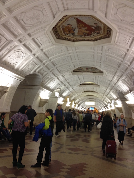
Touring the Top 10 Moscow Metro Stations
By Claudia Looi 2 Comments

Komsomolskaya metro station looks like a museum. It has vaulted ceilings and baroque decor.
Hidden underground, in the heart of Moscow, are historical and architectural treasures of Russia. These are Soviet-era creations – the metro stations of Moscow.
Our guide Maria introduced these elaborate metro stations as “the palaces for the people.” Built between 1937 and 1955, each station holds its own history and stories. Stalin had the idea of building beautiful underground spaces that the masses could enjoy. They would look like museums, art centers, concert halls, palaces and churches. Each would have a different theme. None would be alike.
The two-hour private tour was with a former Intourist tour guide named Maria. Maria lived in Moscow all her life and through the communist era of 60s to 90s. She has been a tour guide for more than 30 years. Being in her 60s, she moved rather quickly for her age. We traveled and crammed with Maria and other Muscovites on the metro to visit 10 different metro stations.

Arrow showing the direction of metro line 1 and 2

Moscow subways are very clean
To Maria, every street, metro and building told a story. I couldn’t keep up with her stories. I don’t remember most of what she said because I was just thrilled being in Moscow. Added to that, she spilled out so many Russian words and names, which to one who can’t read Cyrillic, sounded so foreign and could be easily forgotten.
The metro tour was the first part of our all day tour of Moscow with Maria. Here are the stations we visited:
1. Komsomolskaya Metro Station is the most beautiful of them all. Painted yellow and decorated with chandeliers, gold leaves and semi precious stones, the station looks like a stately museum. And possibly decorated like a palace. I saw Komsomolskaya first, before the rest of the stations upon arrival in Moscow by train from St. Petersburg.
2. Revolution Square Metro Station (Ploshchad Revolyutsii) has marble arches and 72 bronze sculptures designed by Alexey Dushkin. The marble arches are flanked by the bronze sculptures. If you look closely you will see passersby touching the bronze dog's nose. Legend has it that good luck comes to those who touch the dog's nose.

Touch the dog's nose for good luck. At the Revolution Square station

Revolution Square Metro Station
3. Arbatskaya Metro Station served as a shelter during the Soviet-era. It is one of the largest and the deepest metro stations in Moscow.

Arbatskaya Metro Station
4. Biblioteka Imeni Lenina Metro Station was built in 1935 and named after the Russian State Library. It is located near the library and has a big mosaic portrait of Lenin and yellow ceramic tiles on the track walls.

Lenin's portrait at the Biblioteka Imeni Lenina Metro Station

5. Kievskaya Metro Station was one of the first to be completed in Moscow. Named after the capital city of Ukraine by Kiev-born, Nikita Khruschev, Stalin's successor.

Kievskaya Metro Station
6. Novoslobodskaya Metro Station was built in 1952. It has 32 stained glass murals with brass borders.

Novoslobodskaya metro station
7. Kurskaya Metro Station was one of the first few to be built in Moscow in 1938. It has ceiling panels and artwork showing Soviet leadership, Soviet lifestyle and political power. It has a dome with patriotic slogans decorated with red stars representing the Soviet's World War II Hall of Fame. Kurskaya Metro Station is a must-visit station in Moscow.
Ceiling panel and artworks at Kurskaya Metro Station

8. Mayakovskaya Metro Station built in 1938. It was named after Russian poet Vladmir Mayakovsky. This is one of the most beautiful metro stations in the world with 34 mosaics painted by Alexander Deyneka.

Mayakovskaya station

One of the over 30 ceiling mosaics in Mayakovskaya metro station
9. Belorusskaya Metro Station is named after the people of Belarus. In the picture below, there are statues of 3 members of the Partisan Resistance in Belarus during World War II. The statues were sculpted by Sergei Orlov, S. Rabinovich and I. Slonim.

10. Teatralnaya Metro Station (Theatre Metro Station) is located near the Bolshoi Theatre.

Teatralnaya Metro Station decorated with porcelain figures .

Taking the metro's escalator at the end of the tour with Maria the tour guide.
Have you visited the Moscow Metro? Leave your comment below.

January 15, 2017 at 8:17 am
An excellent read! Thanks for much for sharing the Russian metro system with us. We're heading to Moscow in April and exploring the metro stations were on our list and after reading your post, I'm even more excited to go visit them. Thanks again 🙂

December 6, 2017 at 10:45 pm
Hi, do you remember which tour company you contacted for this tour?
Leave a Reply Cancel reply
You must be logged in to post a comment.
Please go to the Instagram Feed settings page to create a feed.
- History of cooperation
- Areas of cooperation
- Procurement policy
- Useful links
- Becoming a supplier
- Procurement
- Rosatom newsletter
© 2008–2024Valtiollinen Rosatom-ydinvoimakonserni
- Rosatom Global presence
- Rosatom in region
- For suppliers
- Preventing corruption
- Press centre
Rosatom Starts Life Tests of Third-Generation VVER-440 Nuclear Fuel
- 16 June, 2020 / 13:00
This site uses cookies. By continuing your navigation, you accept the use of cookies. For more information, or to manage or to change the cookies parameters on your computer, read our Cookies Policy. Learn more
- Skip to global NPS navigation
- Skip to this park navigation
- Skip to the main content
- Skip to this park information section
- Skip to the footer section
Exiting nps.gov
Alerts in effect, the bloodiest day in american history--hope for freedom.
23,000 soldiers were killed, wounded or missing after twelve hours of savage combat on September 17, 1862. The Battle of Antietam ended the Confederate Army of Northern Virginia's first invasion into the North and led Abraham Lincoln to issue the preliminary Emancipation Proclamation.
Check out this section for answers to all your questions if you are planning a visit to Antietam National Battlefield.
Here you will find more information on the history of the Battle of Antietam as well as links to our Cultural and Natural Resources.
There are many opportunities to help at your National Park.
Follow us on your favorite social media site.
Last updated: December 7, 2023
Park footer
Contact info, mailing address:.
P.O. Box 158 Sharpsburg, MD 21782
301 432-5124
Stay Connected
Explore subjects and stories related to this park.
Antietam Battle App

The Antietam Battle App ® is the perfect Civil War touring partner for your exploration of the Antietam battlefield. Our GPS-enabled touring application will guide you to all the historic spots on this 1862 Civil War battlefield — from the initial fighting at the Cornfield and West Woods to the Sunken Road and Burnside’s Bridge. Onboard historian videos, audio accounts of soldiers from the battle, photos, orders of battle, chronologies, key facts, and more are just a click away.
Learn more: See all FREE apps

Road to Freedom: NC Tour Guide

Road to Freedom: TN Tour Guide

Road to Freedom: VA Tour Guide
Related battles, the battlefields today.

Visit Antietam

Antietam Virtual Tour
Explore antietam.
IMAGES
VIDEO
COMMENTS
Antietam Battlefield Driving Tour. Dunker Church Built in 1852, this modest house of worship for pacifist German Baptist Brethren became a focal point for Union attacks the morning of the battle. North Woods Union Gen. Joseph Hooker's men spent the night before the battle on the Poffenberger farm. At first light the Union attack advanced south ...
Take a battlefield hike on one of Antietam's wonderful trails. See your NPS touring map for locations. Hike the Final Attack for a rigorous walk; Complete the NPS Antietam battlefield scavenger hunt. Do what strikes your fancy. Antietam is a battlefield on which you could spend hundreds of hours and never do the same thing twice.
Explore Antietam in our 360° Virtual Tour! Antietam National Battlefield is one of the most well-preserved Civil War battlefields and a must-see for any Civil War enthusiast. Visit many of the key sites - from the Cornfield to Burnside Bridge - of the bloodiest single-day battle in American history. Use the arrows at the bottom of the tour ...
Click on the map or the menu at the bottom to choose any of the eighteen area tour maps of the Antietam battlefield: Antietam National Cemetery. Boonsboro Pike. Branch Avenue North. Branch Avenue South. Burnside's Bridge. Cornfield Avenue East. Cornfield Avenue West. Hagerstown Pike.
Meeting point. This is a self-guided experience and not an entrance ticket. It begins at America's National Parks Store at Antietam National Battlefield 5831 Dunker Church Rd, Sharpsburg, MD 21782, USA. Be sure to check your email before you begin to download the Action Tour Guide app (separate from the Get Your Guide app).
Our multi-sensoryexploration of the battlefield will connect you with this uniquely compelling drama. Meeting Point: Outside the entrance of the Antietam National Battlefield Park Visitor Center (5831 Dunker Church Rd, Sharpsburg, MD). Duration: 3 Hours (mixture walking & driving)
Private tours of the battlefield for you and your group can be arranged by calling (301) 432-4329. There is a standard tour that lasts three hours, and customized tours are available as well. For more information, visit the Antietam Battlefield Guides website. Many of the tour stops also serve as trailheads for the ten hiking trails within ...
Print or download the Tour Map. Watch the Antietam Animated Map. Download the Antietam Battle App, if you want more detail and touring assistance; Learn about John Brown's Raid and Harpers Ferry; Learn about the Battle of South Mountain; Learn about the Battle of Monocacy. Stop #1: Antietam National Battlefield . Time: 4-6 hours (7-8 if you ...
It is now known to history as the Bloody Lane. The War Department built an observation tower at the east end of the Sunken Road in 1897 that gives a perspective over much of the battlefield. Click on the map or select from the menu below to see the page for any monument, marker or place: monuments. Brigadier General George B. Anderson.
Smoketown Road North. On the north end of the battlefield Mansfield's 12th Corps moved up to support the early morning attack by Hooker's 1st Corps. It had barely moved to within long range of the Confederate skirmishers and began forming line of battle when Mansfield, concerned that his men were firing on friendly troops, was shot from his ...
The Antietam National Battlefield ( map) is every bit the equal of Gettysburg. The ride through the park is beautiful and a huge contrast to what happened here. From the Park's website: "23,000 soldiers were killed, wounded or missing after twelve hours of savage combat on September 17, 1862. The Battle of Antietam ended the Confederate ...
The Moscow Metro Tour is included in most guided tours' itineraries. Opened in 1935, under Stalin's regime, the metro was not only meant to solve transport problems, but also was hailed as "a people's palace". Every station you will see during your Moscow metro tour looks like a palace room. There are bright paintings, mosaics ...
Official map of Moscow metro since 2005 ©2005 ZAO Metroreklama . Next Previous 6 of 6 . About Me in Short. My name's Arthur Lookyanov, I'm a private tour guide, personal driver and photographer in Moscow, Russia. I work in my business and run my website Moscow-Driver.com from 2002.
The two-hour private tour was with a former Intourist tour guide named Maria. Maria lived in Moscow all her life and through the communist era of 60s to 90s. She has been a tour guide for more than 30 years. Being in her 60s, she moved rather quickly for her age. We traveled and crammed with Maria and other Muscovites on the metro to visit 10 ...
The life tests started after successful completion of hydraulic tests (hydraulic filling) of the mock-up with the aim to determine RK3+ hydraulic resistance. Life tests are carried out on a full-scale research hot run-in test bench V-440 and will last for full 1500 hours. The aim of tests is to study mechanical stability of RK3+ components ...
The Bloodiest Day in American History--Hope for Freedom. 23,000 soldiers were killed, wounded or missing after twelve hours of savage combat on September 17, 1862. The Battle of Antietam ended the Confederate Army of Northern Virginia's first invasion into the North and led Abraham Lincoln to issue the preliminary Emancipation Proclamation.
The Antietam National Battlefield has an excellent Visitor Center which is a good place to start your visit. Hiking trails and a 8.5 mile driving tour of the battlefield makes it easy to see this historic site. The historic Dunker Church was rebuilt on its original site, and several family farms that were used during the battle have been preserved.
The Antietam Battle App® is the perfect Civil War touring partner for your exploration of the Antietam battlefield. Our GPS-enabled touring application will guide you to all the historic spots on this 1862 Civil War battlefield — from the initial fighting at the Cornfield and West Woods to the Sunken Road and Burnside's Bridge. Onboard ...