

Get My PNW Presets!
This preset collection can enhance your photos and will help you define your style and save you time.
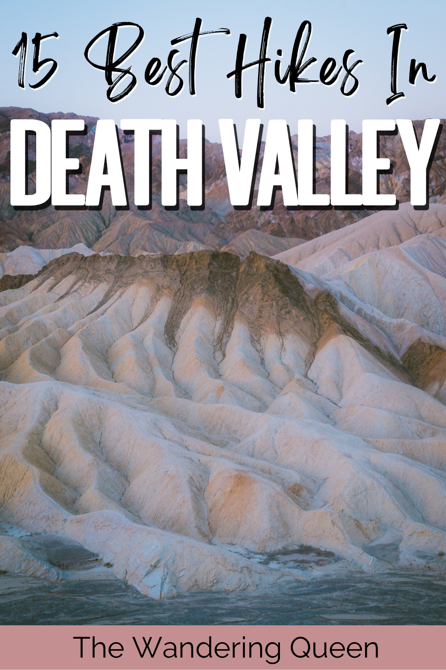
Best Hikes in Death Valley National Park: 15 Unique Hiking Trails
If you’re looking for a hike that will take your breath away, literally and figuratively, then you’re sure to find the ideal trail in Death Valley. Or, if you’re seeking something casual with incredible views, then this US park has you covered, too.
Death Valley is home to many hiking trails ranging from easy to strenuous, so there’s something for everyone. So what are you waiting for? Lace up your hiking boots, pack in your sunscreen, grab your water bottle and get ready to tackle some of the best hikes in Death Valley.
Wondering what else this beautiful destination has to offer? Check out this guide on the best Death Valley things to do .
Disclosure: This post contains affiliate links. If you click one of them, I may receive a small commission (for which I am very grateful for) at no extra cost to you.
Death Valley National Park
Related posts.
- Where to Stay in Death Valley | 13 Hotels, Resorts & Camping Spots
- 21 Fun Things To Do In Death Valley National Park
- The Ultimate 3 Days in Death Valley Itinerary | A Complete Guide
- Best Time to Visit Death Valley National Park
Tours Of Death Valley
What to pack for hiking death valley.
- Sunscreen: This is a no brainer. There are areas on the trail where there is no shade. Slather some on right before the trek. >Buy Sunscreen
- Hiking Boots/Shoes: If you use tennis shoes you can easily hurt your toes hitting a rock by accident (Trust me I have done it so many times before). >Check Out My Hiking Shoes
- Hiking socks: Having the correct socks helps you prevent getting blisters. Smart Wool is probably my favorite brand out there. >Buy Hiking Socks
- Refillable water bottle: I always bring a Hydroflask on all my adventures. They are on the heavier side, but I know for a fact they will not break. I have had a few cheap water bottles break on me before. There is no room for error at Death Valley. >Check Prices Now
- Lots of water: Death Valley is HOT. Bring a ton of water!
- Sunglasses: Like I said, it can get pretty sunny. >Check Out These Sunglasses
- Snacks: The best snacks are jerky, nuts, energy bars. Cliff Bars are great for hiking .
- Trekking Poles: This is an optional product, but they really help with the knees. The poles I have listed are known to be one of the best in the market. >Buy The Trekking Poles Here
- Camera: I have linked the camera I used to take pictures of the Grand Canyon. The Sony A6000 is a great camera for people that want to start improving at travel photography. >Buy Sony Camera Here
- First Aid Kit: This is one of the first things I bought when I first started backpacking and camping. It is super portable. >Buy This Awesome First Aid Kit Here
- Day Pack: The REI bag I have linked, we have had for seven years now, and it is still going strong! >Buy This Great Quality Backpack
- Good hiking pants: These are probably the best hiking pants that I have found. They keep you dry in the crazy weather, and they are durable. >Buy my hiking pants here
- Breathable sweat-wicking shirts : >Check This One Out
- Sports Bra: For women. >Buy One Here
- Jacket: Only in the winter >Buy My Favorite Jacket
- National Park Pass: I highly recommend getting a year-long America The Beautiful Pass. >Get It Here
- Map: I love the National Geographic Maps! They are the best! >Buy One Here

Claim your FREE Hiking Checklist
Ready to start hiking? Grab my free hiking checklist and never forget anything at home!
Where to Stay When Hiking in Death Valley
Since you are going to need several days in the park to experience all that it has to offer, you will need comfortable accommodation to rest, too. Here are some of the best places to stay when visiting Death Valley.
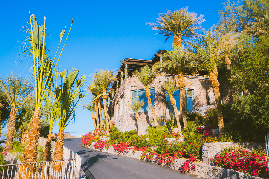
Luxury: The Inn at Death Valley
The Inn at Death Valley is an AAA-rated four-diamond resort that once served as an exclusive desert escape for many of Hollywood’s elites. Today, it aims to bring the elegance of Old Hollywood to each of its valued guests by providing the most luxurious experiences.
At the resort, you will find a variety of stylishly-appointed rooms. These come equipped with modern amenities, including a flat-screen TV, a private bathroom, and plenty more.
There are also plenty of facilities for you to enjoy. This includes a spring-fed swimming pool, a beautiful garden, a state-of-the-art gym, and a relaxing spa. There’s also a restaurant serving some of the best American cuisines. And when you’re not out exploring Death Valley, enjoy activities such as tennis and golf, too. >>> Check Availability
Mid-range: Panamint Springs Motel & Tents
Panamint Springs is a small, western-style resort located in Death Valley’s Panamint area. For those seeking affordable accommodation near many of the national park’s top attractions, this is a great pick.
Panamint Springs offers a variety of accommodation types. This includes 14 historic motel rooms, 9 new cabin-style motel rooms, a cottage, and several tent cabins. There are also several RV sites and campsites on the premises for those looking to rough it out.
Regarding amenities, Panamint Springs has you covered, too. You’ll find a lovely restaurant and bar that serves some of the best Angus Beef Burgers and American-made craft beer. There’s also a gas station and general store here, so you can pick up whatever you may need for your hiking trips. >>> Check Availability
Budget: Camp in Death Valley
One of the best and most budget-friendly ways to experience Death Valley is by camping. There are many campgrounds found throughout the national park—each with its own unique charms.
Some of the most popular developed campgrounds include Furnace Creek, Emigrant, Texas Springs, Sunset, Wildrose, Stovepipe Wells, and Mesquite Spring. These are generally open on a first-come-first-serve basis, so you will need to travel here to find an empty spot.
There are also several private-owned campgrounds, as well as primitive campgrounds. >>> Find out more
Read More: Where to Stay in Death Valley | 13 Hotels, Resorts & Camping Spots
Map Of Best Hikes In Death Valley National Park
15 Best Death Valley Hikes
If you’re seeking a thrilling outdoor adventure, Death Valley is a great place to explore. Here are some of the best hiking trails located throughout the national park.
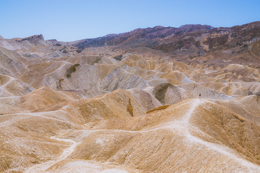
Zabriskie Point
- Elevation Gain: 50 feet
- Mileage: 0.4 miles (out and back)
- Difficulty: Easy
- Trail Guide: Link
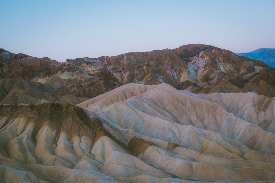
Zabriskie Point is, without a doubt, one of the most scenic viewpoints in Death Valley National Park. And best of all, it is easily accessible via a short path, making it a suitable pick for most visitors.
Most people flock to the iconic Zabriskie Point during sunrise to catch a glimpse of the beautiful badlands as it takes on a violet, pink, and golden hue with the crack of dawn.
The natural phenomenon is especially popular amongst photographers who visit to capture award-winning images of Death Valley. If this sounds like you, then be sure to bring along your camera gear .
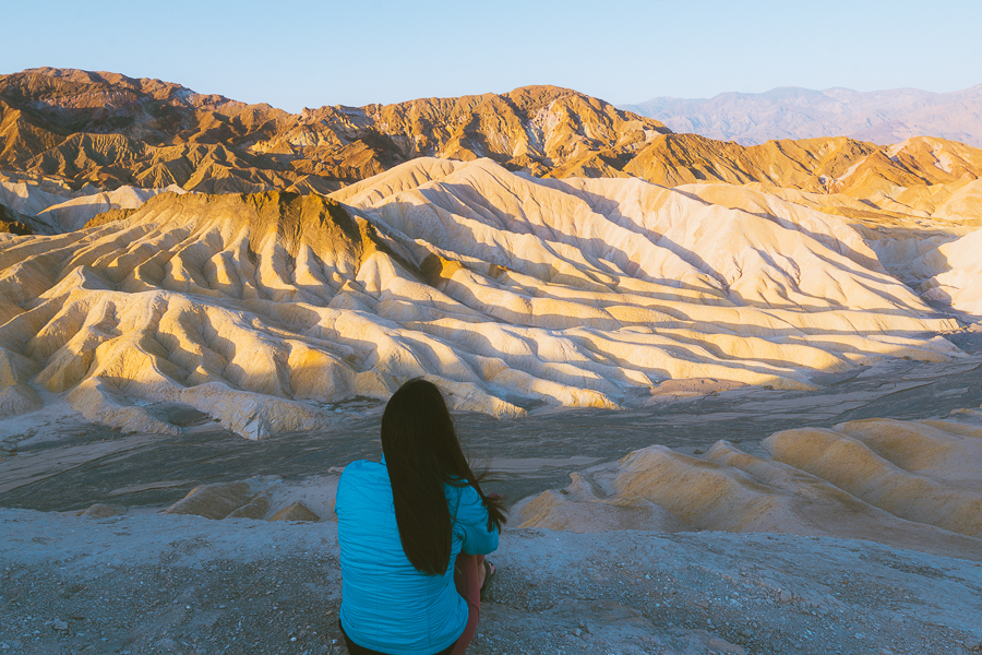
While sunrise is certainly the most popular time of day to visit, sunset offers some incredible views, too. If you’re looking to avoid the larger crowds, arrive as early as possible or visit later in the day.
Regardless of when you visit, you’ll still be able to enjoy breathtaking views of the dramatically eroded terrain and various sights. This includes Manly Beacon, Red Cathedral, and the giant elephant toes.
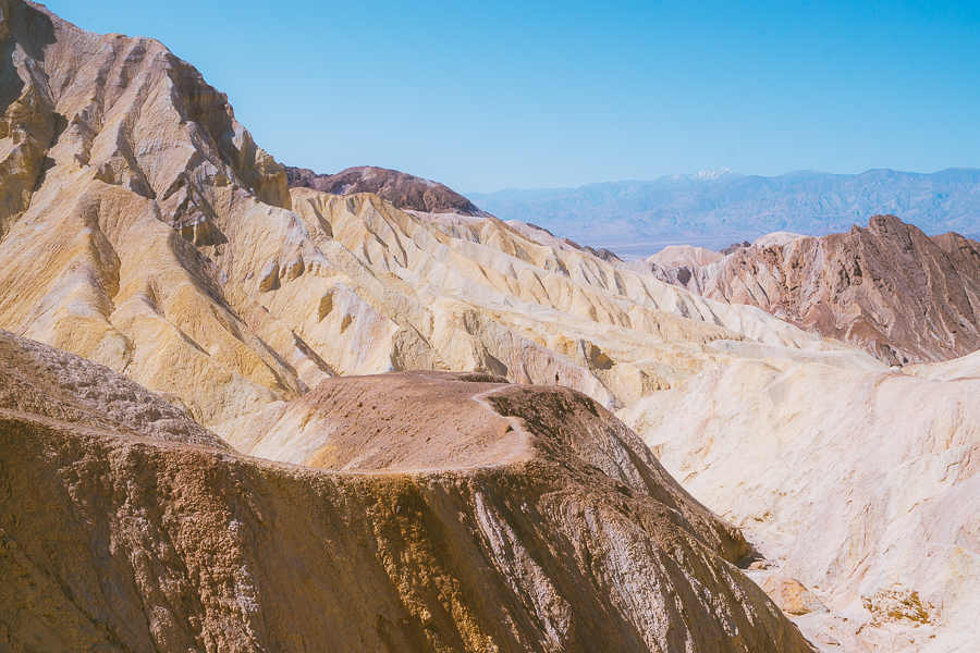
Badlands Loop
- Elevation Gain: 535 feet
- Mileage: 2.7 miles (loop)
- Difficulty: Moderate
From Zabriskie Point, you can continue down onto the 2.7-mile Badlands Loop. This will provide you with a unique opportunity to explore the ridges of the badlands and see the beautiful streaks of color up close.
The trail involves a gradual descent down through an expanding gully. Shortly in, you’ll find yourself in one of the major arteries of Gower Gulch. At this point, you can choose to turn left towards Gower Gulch or right, which will lead you out of the wash.
Many opt for the easier route to the right as it takes you up the dried mudstone walls before opening up to more views of the badlands and various other Death Valley attractions, including Manly Beacon and Red Cathedral.
Tip: Follow the loop after sunrise as the soft morning light compliments the slopes’ unique colors and textures.
Golden Canyon – Gower Gulch Loop
- Elevation Gain: 1,082 feet
- Mileage: 6.4 miles (loop)
- Trail Guide: Link
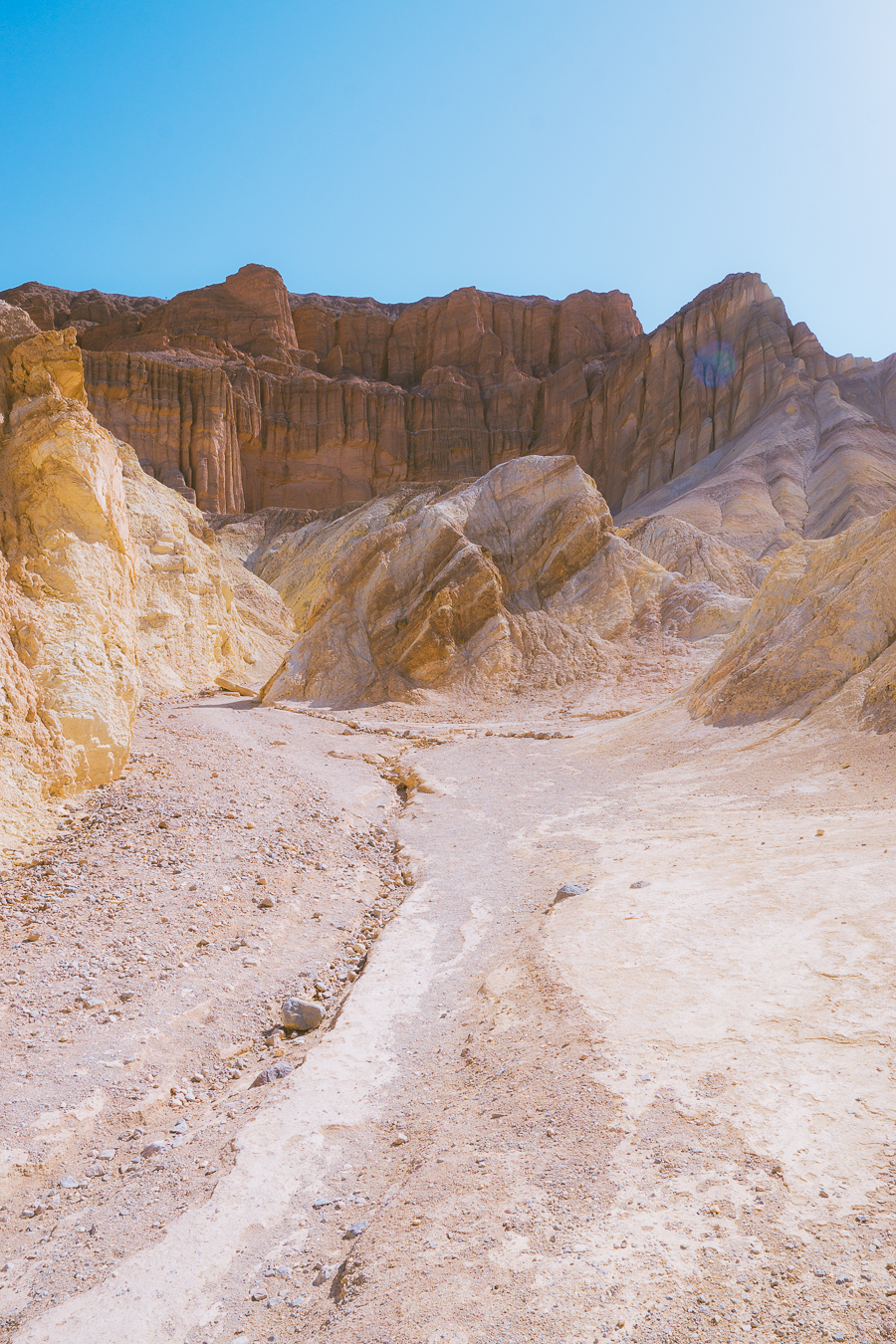
Golden Canyon is one of the most popular attractions in Death Valley National Park. In fact, it is the location for several Star Wars scenes. In addition to this, it is renowned for being one of the park’s most beautiful trails.
While you can do the Golden Canyon Trail on its own as an out-and-back, doing it with the Gower Gulch Trail as a loop is recommended. This route comprises an uphill, rocky climb and requires some scrambling.
This will take you through colorful rock faces toward the famous Red Cathedral. You’ll also pass by Manly Beacon before reaching the red rock formation.
Following this, you’ll have two options. You can make your way back to the parking lot and complete the loop or continue your descent down into Gower Gulch. This can be challenging as there is no firm trail heading down. However, the views are stunning, and you’ll have an easy way out of the wash once you’ve reached the bottom.
Tip: Come early, as this Death Valley trail gets crowded quickly.
Telescope Peak Hike
- Elevation Gain: 3,323 feet
- Mileage: 12.7 miles (loop)
- Difficulty: Hard
If you’re seeking something more challenging, then this is the trail for you. Telescope Peak sits 11,049 feet above sea level and is the tallest point in Death Valley National Park. As you can expect, reaching the summit is quite challenging. However, the views from the top make it more than worthwhile.
Begin the hike at the trailhead near Mahogany Flat Campground and begin your climb up the eastern slope of the Panamint Mountains. This portion of the trail is pleasant as it is lined with Pinyon pine trees. Then, the vegetation slowly clears, providing you with clear views over the valley.
Following this, the trail travels below Rogers Peak, overlooking Hanaupah Canyon. It then levels out at Arcane Meadows, where you’ll have views of both Panamint and Death Valley. This location is a popular camping spot for backpackers. If this is you, make sure you’ve got all your backpacking essentials .
The remainder of the trail follows a narrow ridgeline, occasionally passing by limber and ancient bristlecone pines. This portion experiences a significant 1000-ft gain before reaching the summit of Telescope Peak.
Download my free Outdoor Photography Guide
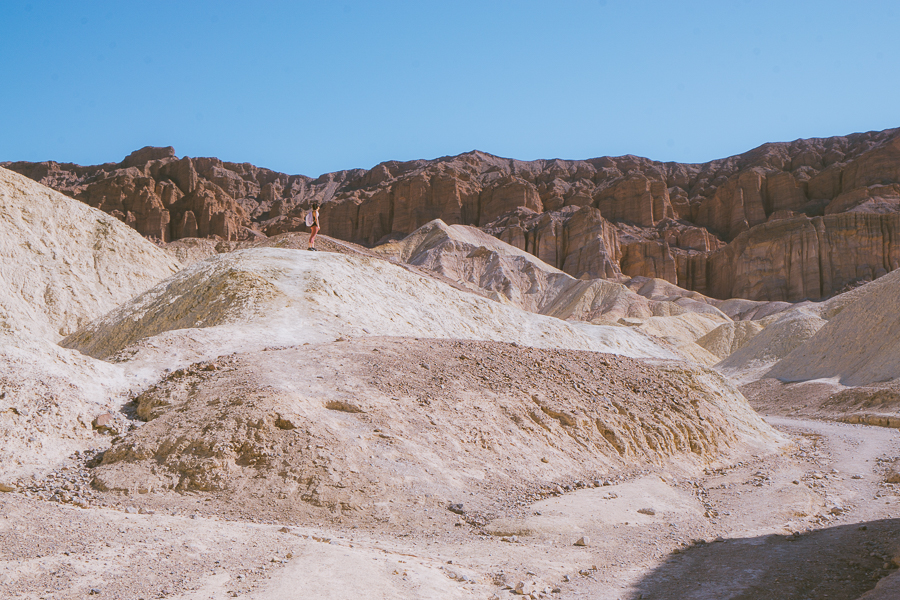
Artist’s palette hike.
- Elevation Gain: 108 feet
- Mileage: 0.3 miles (out-and-back)
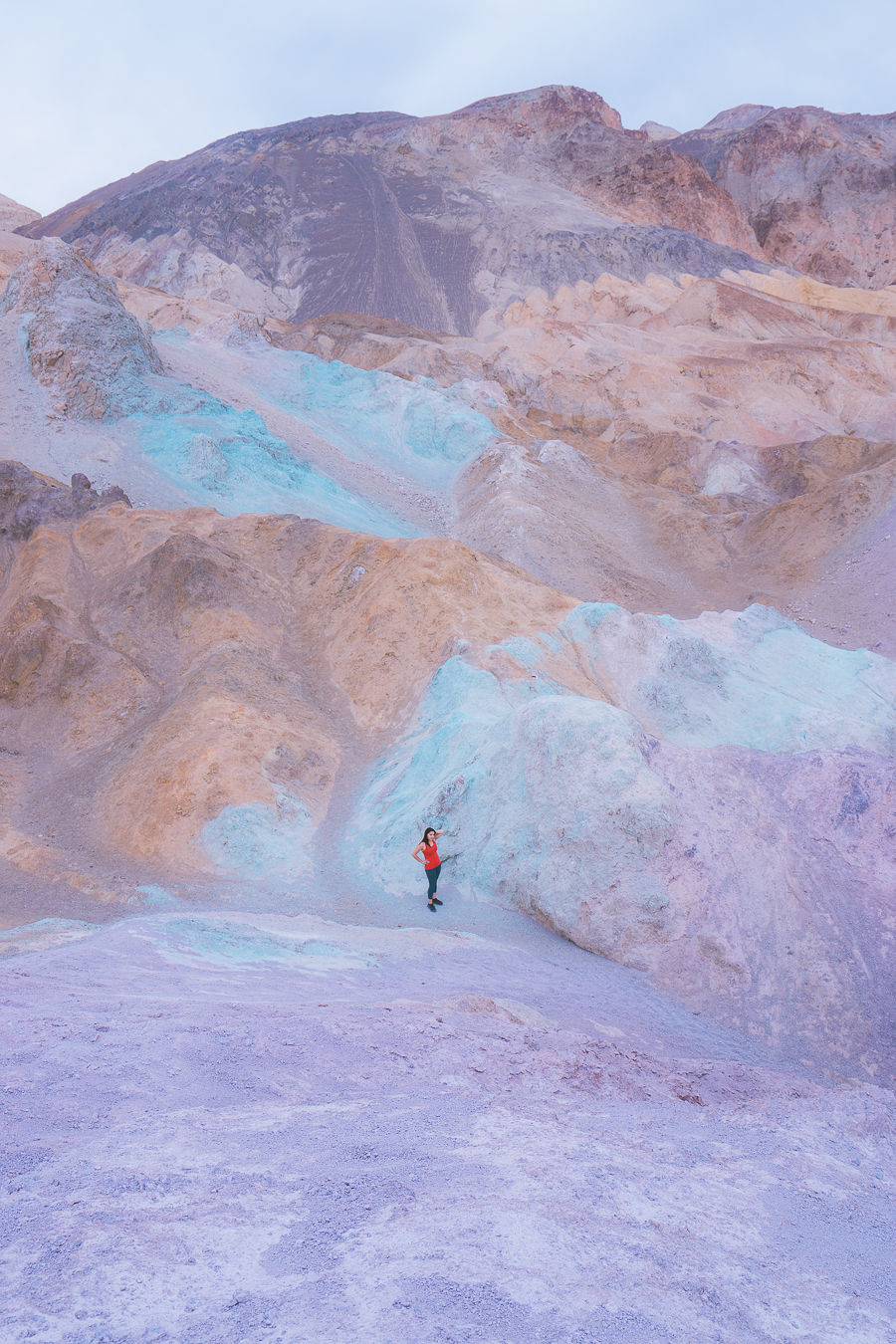
Artist’s Drive and Artist’s Palette are two of the most popular sights in Death Valley. The natural wonder is a result of magma-heated water, lava, and ash. The result is a colorful mineral deposit comprising everything from lavender, blues, and greens to pinks, reds, and browns.
To access this attraction, take a scenic drive up toward the Artist’s Palette Viewpoint. You can choose to view Painted Hills from here or descend down into the wash for a close-up look. There is no designated trail down, so you’re free to explore the wash to your heart’s content.
To see each of the colors come to life, it is best to visit during sunrise or sunset. The sunlight really changes the look of the landscape, making it the perfect subject matter for your Death Valley photos and Instagram feed.
Read More: Best Hikes in Pinnacles National Park: 10 Thrilling Hiking Trails
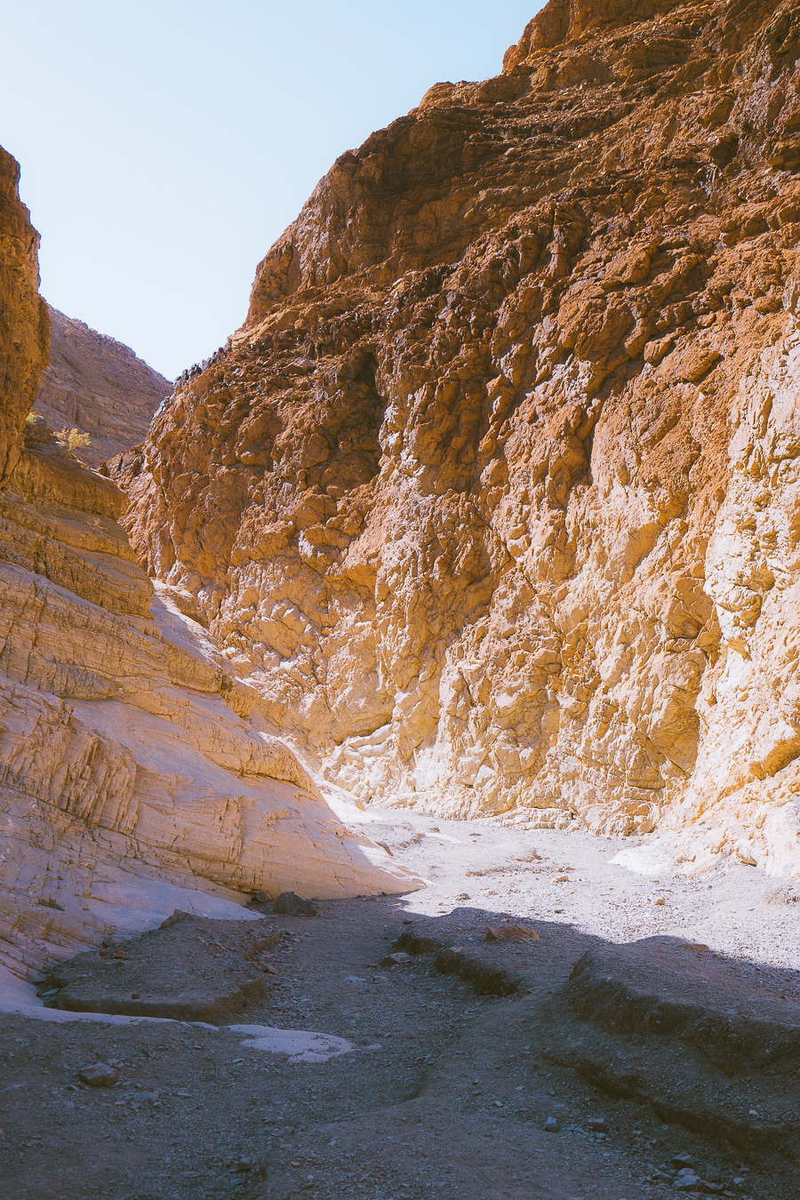
Grotto Canyon
- Elevation Gain: 672 feet
- Mileage: 2.1 miles (out-and-back)
The next entry on this list is a lesser-known trail. This is largely due to the trail being a bit too challenging for most. The trail involves everything from climbing to scrambling—and everything in between.
The trailhead is located near the Mesquite Flat Sand Dunes and Stovepipe Wells and can be accessed via an unmarked gravel road. Shortly after starting the hike, the trail canyon begins to narrow before introducing two challenging obstacles.
The first is a 15-ft climb up a rocky surface, which may require rope and a harness. The second is another climb with smaller rocks to help you grip. Later on, you’ll stumble upon another obstacle that will prove to be more challenging than the ones encountered at the beginning of the trail. This is a strenuous climb up an 8-ft chimney that requires good upper body strength and climbing experience.
Lastly, you will have to bypass a high pour-over, as well as a high wall of chockstones wedged between water-polished walls. Following this, many hikers choose to turn back if they have not done so already. From here, you’ll be met by a new series of challenges as you make your way back down toward the trailhead.
Tip: As this trail involves a lot of climbing, ensure that you have the appropriate hiking gear .
Badwater Basin Salt Flats Trail
- Elevation Gain: 7 feet
- Mileage: 1-5 miles (out-and-back)
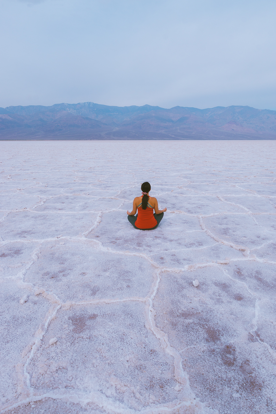
Another must-visit attraction in Death Valley National Park is Badwater Basin. This is the lowest point in North America, sitting at 282 feet below sea level.
The basin is filled with Sodium Chloride—better known as table salt. Don’t believe me? Then be sure to taste the salt yourself.
The hike to this natural wonder is easy, comprising a mostly flat walk along a boardwalk. This will take you to the edge of the salt bed. From this point, you can step onto the hexagon-shaped salt crystals and begin exploring.
The walk from one side of the basin to the other is around 5 miles, though you can choose how far you wish to go. Just be mindful of the borders, as stepping on these will cause them to collapse. While you wander around, be sure to snap pictures of the seemingly never-ending crystal salts and the tall mountains in the background.
Tip: Do not visit Badwater Basin during the heat of the day as the trail offers no shade.
Mosaic Canyon Trail
- Elevation Gain: 958 feet
- Mileage: 3.3 miles (out-and-back)
If you’re into interesting rock formations, then be sure to tackle the Mosaic Canyon hiking trail. Here the canyon walls are lined with thick slabs of marble, which is completely cool to the touch. As such, it is one of the best summer hiking destinations as the temperature remains cool thanks to the canyon walls.
Many will find that this is one of the most rewarding and enjoyable hikes in Death Valley National Park. To start, head to the trailhead near Mosaic Canyon Road. From here, you will follow an easy, flat trail toward the first set of narrows.
Following the first stretch, you will need to do a fair bit of climbing and scrambling before reaching a beautiful amphitheater with a dry fall at the end. Many visitors opt not to do this portion as it is far more challenging.
Regardless, the hike is still worthwhile, as seeing the smooth, natural mosaic at the beginning trail remains a must.
Tip: Wear a good pair of hiking shoes as the rocks tend to be slippery.
Natural Bridge Canyon
- Elevation Gain: 450 feet
- Mileage: 1.4 miles (out-and-back)
The trail to Natural Bridge is one of the easier routes found within Death Valley National Park. It takes you to a stunning natural bridge that was left behind following the erosive effects of water on the canyon walls.
To start the hike, head to the trailhead located along Natural Bridge Road. From the parking lot, follow the relatively easy trail down into the mouth of the canyon. The route experiences little elevation; however, it is rock and can be narrow and uneven at times. As such, you should be sure to watch your step.
Not far in, you will stumble across the famous natural bridge, which extends across the breadth of the canyon. Spend some time admiring the beautiful rock formation before heading back to the parking lot. For those seeking more adventure, you can also travel further as there is a dry fall not too far from the bridge.
Salt Creek Interpretive Trail
- Elevation Gain: 0 feet
- Mileage: 0.5 miles (out-and-back)
The Salt Creek Interpretive Trail is another easy hike that’s perfect for the entire family. It involves an easily accessible wooden boardwalk, which is open year-round. However, it is best to visit between November and May as you’ll find pools of water within the creeks.
From the well-maintained boardwalk, look into the pools to try and spot the Death Valley pupfish. This is a small endangered species of fish endemic to only two sections of the park. If you’re visiting with kids, they’re sure to love this.
This trail is also popular amongst birders as it is where you’ll see the largest variety of bird species in all of Death Valley. Bring your binoculars and try to spot the northern flicker, belted kingfisher, and various other birdlife. There’s also a wide variety of reptiles, including the long-nosed leopard lizard and desert iguana.
Grab Your Free Car Camping Checklist! 🚗🌲
Ready to elevate your car camping game? Snag our essential checklist to ensure you’ve got everything you need for a stress-free, fun-filled adventure! Perfect for beginners and seasoned campers alike. Download now and hit the road prepared! 🌟🎒
Mesquite Flat Sand Dunes Hike
- Elevation Gain: 206 feet
- Mileage: 2.8 miles (out-and-back)
- Difficulty: Easy/moderate
The Mesquite Flat Sand Dunes hike is one of the most popular Death Valley trails. This is because it is fun for both adults and kids.
There is no formal trail, so you can wander around as you see fit. However, if you wish to climb the tallest dune, you will need to walk around 2 miles there and back.
The best time of day to visit the sand dunes is during sunrise or sunset. This is because the temperatures are cooler, and the sunlight brings out the vibrant color of the soft, loose sand.
The Mesquite Flat Sand Dunes is also a popular spot amongst photographers as the vast desert landscape makes for some incredible shots. As it is easily accessible, you’ll likely see weddings, engagements, or other photoshoots taking place here.
Tip: Bring plenty of water, especially if you’re visiting during midday.
Darwin Falls Trail
- Mileage: 2 miles (out-and-back)
While it certainly is surprising to find bodies of water within this desert, nothing quite beats Darwin Falls. After all, a waterfall is the last thing anyone would expect to find in this US national park.
Reaching the waterfall includes an adventurous route along a dusty canyon. While it is unmarked, it is not too difficult to follow as it winds its way along the desert wash into the canyon.
The last portion of the trail takes you alongside the creek, where you will find a couple of streams. Be cautious, as the rocks here are slippery. After ducking under a few tree limbs, climbing over rocks, and making your way past several river crossings, you will reach the lush oasis and flowing waterfall.
At the waterfall, you will be able to sit and relax. Admire the beauty of this hidden gem, as well as the various bird species and dragonflies found here.
Note: It is not permissible to swim at the waterfall.
Desolation Canyon Hike
- Elevation Gain: 723 feet
- Mileage: 3.8 miles (out-and-back)
Desolation Canyon is one of the more secluded trails found in Death Valley National Park. On this hike, explore the eroded volcanic landscape and admire the unique colors and rock formations found throughout.
Desolation Canyon is one of the most scenic hikes; however, it is also one of the more challenging picks. This is because the trail involves a fair amount of climbing and scrambling.
The beginning of the trail features a broad gulch, which quickly narrows down. As such, you’ll need to twist into some tight passages as you make your way uphill. Around a mile in, you’ll encounter an 8-ft dry fall. This includes handholds, making it easy to climb.
While it’s easiest to simply follow the main canyon route, exploring the smaller canyons found along the way is recommended, too. After taking in views of the various geologic elements found in the canyon, continue along the main route until you’ve reached the end of the trail.
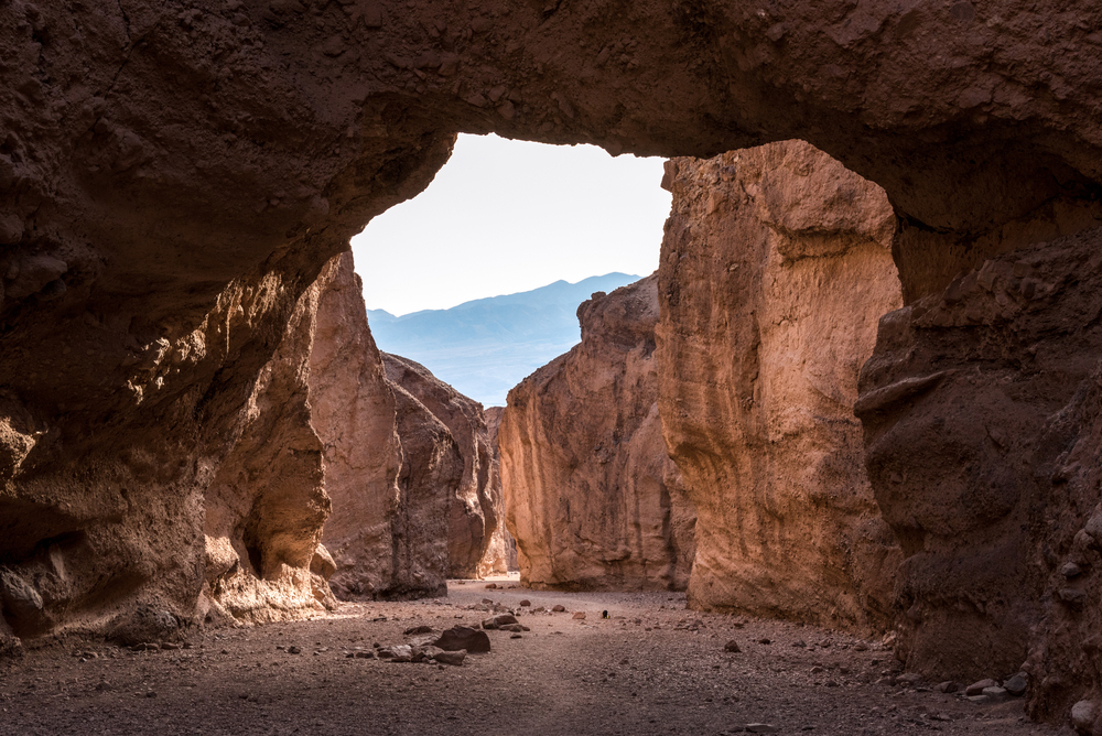
The end is a viewpoint overlooking Death Valley. From here, you’ll have incredible views over Artist’s Drive, the Black Mountains, and plenty more.
Ubehebe Crater Rim Hike
- Elevation Gain: 500 feet
- Mileage: 1.5 miles (loop)
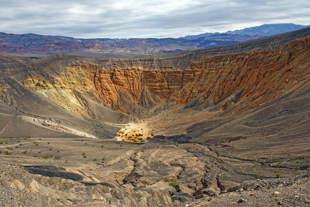
Ubehebe is one of the most incredible sights in Death Valley National Park. It is a large volcanic crater that measures 600 ft deep and 0.5 miles across.
While the crater can be viewed from the parking area, further exploration is advised. As you walk along the rim, you will feel as if you’re on Mars.
You will also be able to walk down into the crater to see the smaller craters and interesting erosion up close. This should be done with caution as the way back is incredibly steep, and the loose gravel is hard to grip.
To ensure your safety, it is best to stay on the trail. Many visitors opt to do the hike anti-clockwise as this allows you to get the climbing out of the way early on.
Ibex Dunes
- Mileage: 6 miles (loop)
When it comes to solitude, nothing quite beats the Ibex Dunes trail. This is largely due to the dune being hard to reach. You will need to travel with a 4WD along the roughest road in the park to access this natural wonder.
Once you’ve reached the Ibex Dunes, you’ll be met by a seemingly endless field providing some of the most breathtaking panoramic views. Take your time traversing the dunes. Many visitors opt to hike to the talc mine at the end of the trail before turning back.
Do note that navigating the dunes can be challenging. As such, it is best to bring along some sort of mapping tool to ensure you’re able to reach your destination and backtrack your steps back to your 4WD vehicle.
Tip: Do this Death Valley hike in the morning to avoid the midday heat.
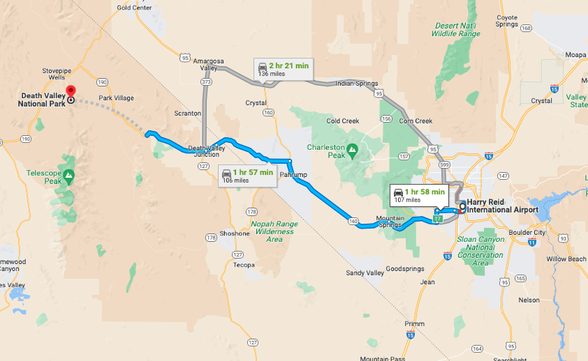
How to Get to Death Valley National Park
Now that you know what the best Death Valley hikes are, the next question on your mind may be how to get there.
Death Valley is located in central California near the Nevada border. The two major airports found closest to the national park are Harry Reid and Los Angeles International Airport. There is no public transportation that travels to Death Valley, so you will need to travel by car.
From Los Angeles, the drive is around 3.5 hours. This can be as long as 4.5 hours, depending on the traffic. This follows a scenic route up US Route 395 toward the park’s western entrance.
If you’re driving from Las Vegas, you’ll have a shorter journey of around 2 hours. This will take you through Death Valley Junction, a small near-ghost town commonly referred to as Amargosa (meaning “bitter” in Spanish).
Note: There are not many gas stations along the way, so be sure to start your journey with a full tank.
Best Time to Go Death Valley Hiking
The best time to go hiking in Death Valley National Park is between November and March, which includes winter and early spring. During this time, the weather is mostly mild, with low temperatures ranging between 39ºF and 54ºF and highs between 68ºF and 77ºF. As spring approaches, this can be as high as 93ºF.
While the temperatures are high during spring, this is the most popular time to visit Death Valley. Besides providing warm and sunny days, many people flock to the national park to view the beautiful spring wildflowers. The spring break season (March to April) also brings about large crowds. So if you’re seeking greater solitude, then the winter months are best.
For the most part, it is best to avoid hiking in Death Valley during the summer months as temperatures are dangerous—particularly in the park’s lower elevations. As such, to enjoy trails like Zabriskie Point without succumbing to the park’s summer heat, staying clear of these months is best.
If you happen to find yourself here during summer, aim to hike in the early hours of the morning between sunrise and 11 am. It also helps to stick to trails that cover the park’s high peaks, as these provide a pleasant escape from the summer heat.
How Many Days Do You Need for Hiking Death Valley
Wondering how many days you need to spend in Death Valley to see all of the park’s top sights and attractions? For most, 2-3 days is best. This will provide you with enough time to explore several of the park’s top trails.
At the same time, it is absolutely possible to see Death Valley in a single day. With one full day, you will be able to see Zabriskie Point, Badwater, Furnace Creek, and Ubehebe Crater. You’ll also have time to stop by the visitor’s center and take a tour of one of the castles.
However, if you want to take your time exploring both the popular and more secluded spots by foot, a day or two extra is recommended.
Death Valley National Park Hiking: FAQs
Below are a few more frequently asked questions to ensure you’re all clued up with Death Valley hiking.
When Should You Avoid Hiking in Death Valley?
It is best to avoid hiking in Death Valley during the summer months, particularly in July. During this time, the national park is extremely hot, with lows of 90ºF and highs of up to 134ºF.
How Much Water Should You Carry in Death Valley?
Rangers recommend carrying at least one gallon of water per person, if not more. This is because dehydration and heat exhaustion are common here, given the hot and dry climate.
Do Cell Phones Work in Death Valley?
In Death Valley, cellular service is limited. As such, some people may experience slow service in some areas. There is also no WiFi in the national park other than what is provided by some of the hotels and resorts.
Does GPS Work in Death Valley?
GPS Navigation has proved to be unreliable in Death Valley National Park. As such, it is best to carry a road map with you at all times to double-check the accuracy of your GPS.
Are There Animals in Death Valley?
There are many animals in Death Valley, including mountain lions, rattlesnakes, coyotes, and bighorn sheep . To ensure your safety, read this guide on wildlife safety tips .
Experience the Best Hikes Death Valley Has to Offer
There you have it, a list of Death Valley’s best hikes. From casual hikes like Zabriskie Point to the more strenuous Grotto Canyon trail, there is an adventure for everyone. And don’t limit yourself to a single trail, as each of the trails listed offers something different.
Looking for some more incredible hiking opportunities? Head to Las Vegas and tackle some of the best Red Rock Canyon hikes .

Get my free National Park Checklist
When you join the newsletter, pin for later.

Similar Posts

Best National Parks To Visit In Winter

The Ultimate Las Vegas To Valley Of Fire Day Trip Itinerary

13 Best National Parks To Visit In The Fall

The 7 Best Mt. Baker Hikes In Washington State

27 Cozy Cabins In Washington State

The Perfect 5 Day Maui Itinerary
Leave a reply cancel reply.
Your email address will not be published. Required fields are marked *
Save my name, email, and website in this browser for the next time I comment.
This site uses Akismet to reduce spam. Learn how your comment data is processed .
- Skip to global NPS navigation
- Skip to this park navigation
- Skip to the main content
- Skip to this park information section
- Skip to the footer section
Exiting nps.gov
Alerts in effect, backpacking.
Last updated: May 4, 2024
Park footer
Contact info, mailing address:.
P.O. Box 579 Death Valley, CA 92328
760 786-3200
Stay Connected
Ultimate Guide to Death Valley Hiking [2023]

Most people don’t think of the hottest, driest and lowest place in North America as a premier hiking destination. Hiking is only advised in Death Valley for a few months of the year.
If you love to hike, keep reading for details on all of the trails plus everything you need to know about hiking in Death Valley National park.
Table of Contents
When is the best time to hike Death Valley?
Complete List of Hiking Trails at Death Valley
Details on Easy Trails at Death Valley
Details on Moderate Trail at Death Valley
Details on Difficult Trail at Death Valley
Tips for Hiking Death Valley
What is there to do at death valley, best hiking trails in death valley national park.
The Golden Canyon trail system is the best hiking trail in Death Valley National Park if you want to see a lot on a single hike.
If you have limited time or don’t want to hike a lot at Death Valley, then Golden Canyon offers a lot of variety without having to hike multiple trails. Plus it is rated as a moderate trail with two large parking areas for easy access.
Skip to Golden Canyon for photos and detailed route suggestions.
When is the best time to hike at Death Valley?
The best time for hiking Death Valley is between November and March when temperatures are cooler.
Daytime temps can still get warm but not as hot as summer in Death Valley. Due to extremely hot and dry weather, summer hiking is dangerous at Death Valley and should not be attempted.
During cooler winter months, the park offers 21 hiking trails ranging from 0.4 to 14 miles.

Death Valley has an abundance of hiking trails for all fitness and mobility levels.
Below is a summary list in order of the NPS difficulty rating.
Easy Hikes (skip to details below)
- Harmony Borax Works: 0.4 mi (0.6km)
- Salt Creek Interpretive Trail: 0.5 mi (0.8km)
- Badwater Salt Flat: 1 mi (1.6km)
- Natural Bridge: 1 mi (1.6km)
- Mesquite Flat Sand Dunes: 2 mi (3.2km)
Moderate Hikes (skip to details below)
- Ubehebe Crater Loop: 1.5 mi (2.4km)
- Darwin Falls: 2 mi (3.2km)
- Badlands Loop: 2.7 mi (4.3km)
- Golden Canyon: 3 mi (4.8km)
- Desolation Canyon: 3.6 mi (5.8km)
- Mosaic Canyon: 4mi (6.4km)
- Willow Canyon: 4.2 mi (6.8km)
- Gower Gulch Loop: 4.3 mi (6.9km)
- Fall Canyon: 6 mi (9.6km)
- Dante’s Ridge: 8 mi (13km)
Difficult Hikes (skip to details below)
- Sidewinder Canyon: 5 mi (8.4km)
- Panamint Dunes: 8 mi (12.8km)
- Little Bridge Canyon: 7 mi (11.2km)
- Corkscrew Peak: 8 mi (12.9km)
- Wildrose Peak: 8.4 mi (13.5km)
- Telescope Peak: 14 mi (22.5km)

Death Valley Easy Hiking Trail Details
There are five hiking trails in Death Valley with easy ratings.
Some are paved paths and others are wide open areas where you can determine your own path.
Harmony Borax Works
The Harmony Borax trail is a short 0.4-mile paved loop that is ADA accessible.
The educational panels on the walking path share information about the historic Borax mining and processing in Death Valley. It is located 1 mile west of Furnace Creek and has a large parking area with space for RVs.
Salt Creek Interpretative Trail
The Salt Creek Interpretative Trail is one of our 24 Amazing Things to do at Death Valley.
The trail itself is a 0.5-mile wooden boardwalk loop.
However, the main attraction is the Salt Creek pupfish. These tiny fish can be spotted frolicking in Salt Creek along the trail.
Educational signs provide details about how these creatures have adapted to survive in the extreme conditions of Death Valley.
No other aquatic species can survive the high salinity and temperatures of Death Valley. There are a few species of pupfish but Salt Creek is a great place to see them up close.
We visited in early April and were able to see them spawning.
The educational signs explained what this looked like. Otherwise, I wouldn’t recognize pupfish spawning.
Pupfish spawn between February and April so that is the best time for hiking the Salt Creek Interpretative Trail.

Badwater Salt Flats
You cannot visit Death Valley without going to Badwater Basin. I wouldn’t consider this a hiking location.
The hike is more of a path from the parking area across the flats.
Many families walk a portion and turn around once they get too hot or too bored.
But you have to walk about a mile from the parking area to get to the white crusty salt flats that are undeniably Death Valley. Definitely wear sunscreen or long sleeved shirt with SPF and wide brimmed hat .
The first mile of the walk is on cracked and dry ground similar to the flats. However, the salt accumulation is too thin to create a white crust.
Watch your footing. It is really easy to trip if you aren’t paying attention.
This is my favorite picture from Death Valley. Outside of the frame are others posing for pictures that also look “all alone”.

Natural Bridge
Natural Bridge is a popular hiking location at Death Valley but it wasn’t my favorite.
It is only one mile out and back but I struggled in the midday heat. The trail is located near Badwater Basin and Devils Golf course.
The dirt road to the trailhead was a bit washed out in spots and not a fun drive in a sedan.
It is absolutely possible to make the drive to Natural Bridge trailhead in a rental car.
If you have a low-clearance vehicle, you might have to wait for oncoming cars to pass so you can drive on the better side of the road.
If you have never seen a natural arch or bridge, you should definitely take the walk. But prepare to walk up a gravel road for most of the way out. There is a nice view over the valley along the way but it is behind you on the way out.
The walk to Natural Bridge was hot and uphill but I don’t remember much more than I didn’t enjoy it.
The bridge is pretty but doesn’t compare to the numerous arches and bridges we saw in Utah’s National Parks, like Arches and Grand Staircase Escalante .

- Mesquite Flats Sand Dunes
Mesquite Flats Sand Dunes is rated an easy hiking trail in Death Valley.
The trail is listed as 2 miles out and back to reach the highest sand dune. However in reality, you choose your own path and distance.
Mesquite Flats is a section of natural sand dunes. It is located in the Stovepipe Wells Village which is 30 miles from Furnace Creek. The parking area is large with spots for buses and RVs.
There is no marked hiking trail. You are trekking across sand dunes. Visitors just leave their car and walk wherever they like over the dunes.
Mesquite Flats Sand Dunes is a great location to enjoy sunset or sunrise.

Death Valley Moderate Hiking Trail Details
We only did a few of the moderate hikes at Death Valley.
The Golden Canyon and Gower Gulch combination is a great hiking option if you only have time for one trail.
We stayed in Death Valley for 3 days during the first week of April but hiking midday was not an option due to the heat .
Instead, we woke up early while at Death Valley and did our hiking before the temperatures got too hot.
Ubehebe Crater Loop
Ubehebe has several trail options including the 3-mile Ubehebe Crater Loop, the shorter Little Hebe trail, and the steep walk into the crater.
I wouldn’t recommend these walks for anyone with a fear of heights as you walk on the rim of the crater. The steep drop-off warning signs got my heart pumping.

We visited Ubehebe Crater but only walked to Little Hebe Crater and back.
The trail continues around Little Hebe but we only went about 0.5-mile out and 0.5-mile back. It was enough for me.
We visited on an extremely windy day and the cinder ash covering the ground wasn’t easy walking.
Kevin held my hand as I had a mild freak out about falling into the crater. We were safe but being pushed towards a steep drop-off warning sign by strong winds wasn’t a comforting feeling.
The most adventurous hikers can go down a very steep path to the base of the crater. But they have to make the equally steep climb back out afterward.
We saw people of all ages hiking to the base of Ubehebe Crater in Death Valley but we opted out.

Darwin Falls
Darwin Falls is accessed by a rough dirt road near Panamint Springs.
A high-clearance vehicle is recommended but not necessary. It is always best to take to a park ranger about the current road conditions.
Darwin Falls is the only year-round waterfall in Death Valley accessible by established park hiking trails.
The trail is 2 miles out and back with only 450 feet of elevation gain.
Swimming is not allowed at Darwin Falls.

Golden Canyon, Badlands Loop, Gower Gulch Loop
The Golden Canyon, Gower Gulch and Badlands are a series of trails that can be combined in a variety of ways ranging from 3 to 8 miles.
The maze of canyons and trails can be accessed by two trailheads.
Both have large parking areas with toilets.
Golden Canyon trailhead is located on Badwater Road.
Zabriskie Point trailhead is located on CA-190 (to the right of the observation point).

We started at the Golden Canyon trailhead and combined with the Red Cathedral offshoot and Gower Gulch for a total of 5.62 miles.
To avoid the midday heat, we started hiking at 7:30 am after watching the sunrise at Zabriskie Point.
It is a great plan but next time we’d likely start our walk at Zabriskie Point rather than driving to Golden Canyon. We just didn’t realize it was all connected at the time.
This area of Death Valley is a popular hiking destination because it offers a variety of landscapes and terrain to explore. If you only have time for one hike in Death Valley, Golden Canyon is it.
For complete details check out the NPS Golden Canyon page.

Desolation Canyon
Desolation Canyon is located 3.7 miles south of Golden Canyon on Badwater Road.
However, the parking area is only accessible via a dirt road. NPS states the road is “typically passable to sedans”.
The hike is 3.6-mile roundtrip out and back on an unmarked route. Some rock scrambling is required.
For complete details check out the NPS Desolation Canyon page.
Mosaic Canyon
Mosaic Canyon is a 4 mile out and back hiking trail in Death Valley.
After a short walk thru a wash, hikers enter narrow smooth marble canyons. Mosaic canyon breccia can be spotted along the trail.
It is comprised of a variety of parent rocks locked into natural cement stone. The colorful rock pieces look like an artist-created mosaic.
Many hikers turn around after the first few miles when boulders start blocking the canyon floor.
More adventurous visitors crawl over or under the rocks to continue on the trail.
For complete details check out the NPS Mosaic Canyon page.
Willow Canyon and Sidewinder Canyon
Both Willow Canyon and Sidewinder Canyon trails are accessible via a 0.5-mile dirt road located at mile marker 31.5 on Badwater Road.
The Willow Canyon trail is 4.2 miles out and back with 442 feet of elevation gain.
The route is not physically demanding but requires backcountry navigation experience. The canyon and seasonal waterfall are not designated by any signage.
Sidewinder Canyon is 5 miles out and back with 1,580 feet of elevation gain. It is rated as extremely difficult.
The trail requires climbing over vertical ledges and squeezing into tiny slot canyons.
It should only be attempted by Death Valley visitors with a wilderness hiking experience.
For complete details check out the NPS Sidewinder Canyon page.
Fall Canyon
Fall Canyon is a 6 mile out and back hiking trail in Death Valley with 2,460 feet of elevation gain.
It is located 11.9 miles north of CA-190 on Scotty’s Castle Road. The trailhead is located 2.7 miles down Titus Canyon road, an unpaved road that is typically passable by sedans.
For complete details check out the NPS Fall Canyon page.
Dante’s Ridge
The ridge trail starts at Dante’s View scenic overlook at 5,457 feet above sea level and keeps climbing to Dante’s Peak at 5,704 feet.
The trail starts at the north end of the parking area and continues along ridgelines in the Black Mountains.
Many hikers follow the ridge out for a mile or two for the views. The complete trail is 4 miles out and 4 miles back for a total of 8 miles.
Hiking Dante’s Ridge is not recommended if you have vertigo since the majority of the hike has dramatic sweeping views of Badwater Basin (more than 5,500 feet below) and the Valley.

Death Valley Difficult Hiking Trail Details
Death Valley has six hiking trails designated as difficult including Sidewinder Canyon above.
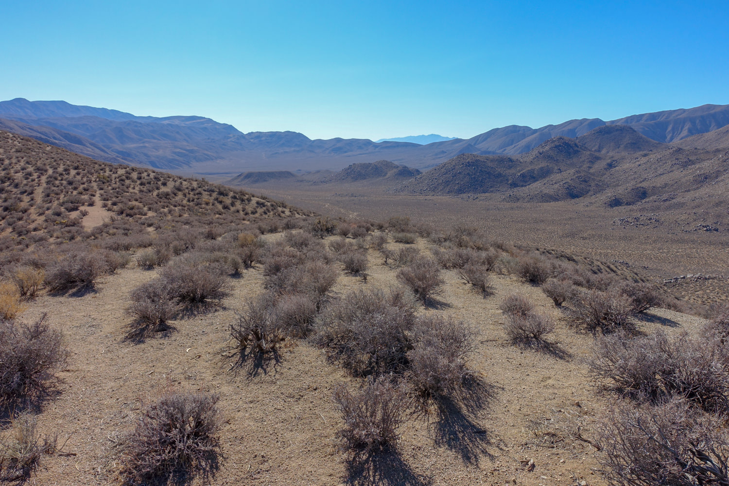
Panamint Dunes
Panamint Dunes is located 4.5 miles east of Panamint Springs. Trailhead access requires a high clearance vehicle.
The unmarked route is sandy, partially rock and uneven.
The 8-mile trail has 1,028 feet of elevation gain which doesn’t begin until around mile 3 when you reach the dunes. Afterward, the trail is sandy and strenuous as you cross over the top of four different dunes.
Little Bridge Canyon
Little Bridge Canyon is 7 miles out and back with 1,900 feet of elevation gain. It is unmarked and located at eastbound mile marker 89 on CA-190.
For complete details check out the NPS Little Bridge Canyon page.
Corkscrew Peak
Corkscrew Peak is a peak in the Grapevine Mountains of Death Valley.
The shape loosely resembles a corkscrew. The trail is a 7 mile out and back with 3,093 feet of elevation gain.
The scenic views attract only the most dedicated hikers.
Inclines after the first 2.5 miles are steep with loose rocks.
Wildrose Peak
Wildrose Peak is located in the Panamint Mountains of Death Valley.
The trailhead for Wildrose Peak is located near the Charcoal Kilns and Wildrose campground.
To learn more about both the charcoal kilns and the campground, check out our Complete Guide to Death Valley.
Wildrose Peak is 8.4 miles out and back with 2,200 feet of elevation gain.
The trailhead and campground are only accessible to vehicles under 25 feet in total length due to steep grades and curves.
Wildrose Peak is a great high-elevation hike for when the valley is hot.
We left 90-degree temps in the valley and arrived at a cool 70-degree day at Wildrose due to the elevation difference. Winter can bring snow to this area.

Telescope Peak
Telescope Peak trail is a 14 mile out and back with 3,000 feet of elevation gain.
It is the longest hiking trail at Death Valley.
The hike is a steady climb through the Panamint Mountains offering a variety of narrow ridges, pine forests and sweeping views of Death Valley. On a clear day, hikers can see the highest peak in the lower 48, Mt Whitney in the Sierra Nevada Mountains.
The trailhead is 1.5 miles past the Charcoal Kilns at the Mahogany Flats campground.
High clearance and 4×4 are recommended for the road beyond the Charcoal Kilns. Those with low-clearance vehicles can park at the Charcoal Kilns and walk along the road to reach the trailhead.
- NPS advises visitors to avoid hiking during summer months .
- During warm shoulder seasons, it is advised to complete hikes before 10 am to avoid the midday heat .
- Due to the dry conditions in Death Valley, hikers should drink more water than usual even in cool winter months. A minimum of 2 liters is recommended for short day hikes and a gallon or more for longer or warmer hikes. Springs are not common and shouldn’t be considered safe for drinking. A hydration bladder is an easy way to carry multiple liters of water hiking.
- Pre-plan your route. Download offline maps before you visit because you will not be able to access the internet while in most of the park. The free Avenza app is a good source for basic National Park offline maps.
- Death Valley is primarily wilderness so share your specific hiking plan in advance with a friend or family member for safety. It will be a lot easier for search and rescue teams if they know where you were headed and your overall hiking plan. Cellular service is not available in most of the park, so communicate your hiking plan before you get to Death Valley.
- Prepare for survival . Death Valley is mostly wilderness and there is a possibility you may get lost or injured during your hike. Pack your daypack knowing this possibility. Bring supplies to survive overnight or longer if necessary. Be as self-sufficient as possible.
- We always hike with a first aid kit , a flashlight , waterproof matches , extra food and water, sunscreen and a multi-tool . Depending upon weather, we also pack extra clothing layers.
- Hike with a partner for safety or if solo, consider an emergency GPS beacon.
What to wear hiking in Death Valley
The sun is brutal in the California desert and knowing what to wear hiking when hiking in Death Valley can be challenging.
If you hate sunscreen like my husband, then wear a long sleeved shirt with SPF and wide brimmed hat .
Due to the overwhelming daytime heat, I chose to wear a tank top and shorts with sunscreen re-applied regularly. I sweat a lot but was happy with the occasional breeze on my bare skin.
Remember night-time temps drop in the desert and you can get cold quickly especially in winter.
For unplanned delays, I usually hike with a lightweight merino wool layer in my daypack. I like the Kuhl Women’s Agility 1/4 zip pullover because it packs smaller than a t-shirt but provides a lot of warmth.
Hiking is fun at Death Valley but the most popular attractions in the park are easy walks from your car.
Everything you need to know before visiting Death Valley can be found in our Complete Guide to Visit Death Valley.
The park covers over 3.4 million acres and driving from Father Crowley’s Viewpoint to Ubehebe Crater is almost 2 hours one way.
Your itinerary will greatly depend on the length of your visit and your travel pace.
Below are a few sample itineraries for Death Valley. To get full details on each attraction, check out 24 Amazing Things To Do at Death Valley: Including the Most Beautiful Can’t Miss Attractions .

Half Day Death Valley Itinerary
One half day visit to Death Valley is enough time to drive around the southern section of the park including:
- Furnace Creek
- Artist’s Palette Overlook and Artists Drive
- Badwater Basin
- Devils Golf course
- Zabriskie Point.
This is a great glimpse into the most popular spots.
You’ll get a feel for the valley and probably get some pretty epic photographs. But if you have more time, you can explore further.
Full Day Death Valley Itinerary
One Full Day at Death Valley allows time to visit the places above plus the ability to add:
- Dante’s View,
- Harmony Borax Works (Twenty Mule Team Drive).
Multiple Day Death Valley Itinerary
If you have more than one day at Death Valley, it allows more time to visit some of the more remote locations in the park.
A few of the most popular destinations for multiple days at Death Valley are:
- Ubehebe Crater
- Wildrose Charcoal Kilns
- Father Crowley Vista Point.
A longer trip also allows time to hike or relax depending on your preference.
Summary Death Valley National Park Hiking
Although hiking is not the primary attraction at Death Valley, its vast wilderness offers something for everyone.
From a short half-mile stroll on a paved path to double-digit mileage with steep elevation gains.

Other California Desert Posts You Might Enjoy
⭐ Joshua Tree in a Day: Everything You Need to Know Before You Visit
⭐ Anza Borrego Desert Sculptures at Galleta Meadows: What You Need to Know Before Your Visit
⭐Anza Borrego in a Day: Experience the Best Things to Do at California’s Largest State Park in One Day
⭐Pinnacles National Park: Conquering a Fear of Heights on the Steep and Narrow Trail
CURRENT PRICES END MAY 12
Outside Festival feat. Thundercat and Fleet Foxes.
GET TICKETS
Start Your Free Trial
Powered by Outside
The Best Dayhikes in Death Valley National Park
Explore the desert with our favorite hikes, short and long..
Heading out the door? Read this article on the new Outside+ app available now on iOS devices for members! >","name":"in-content-cta","type":"link"}}'>Download the app .
Death Valley National Park is a year-round hiking playground, and as you might imagine, offers even more options in the winter and spring than the hot summer months. If you are looking for a fall-through-spring destination, this could be your Shangri-La.
“People expect flat, boring landscapes,” says Death Valley National Park Ranger Tom Arnold, “but there are also 11,000-foot mountains and sand dunes. It’s an unexpected gem with an endless amount of adventure.”
Arnold explains that the hiking in Death Valley is different, unique and unusual. “It’s like the Wild West of hiking, so you should start slow and easy to get a feel for it.”
Looking for the best that Death Valley National Park has to offer? Start with these recommendations from an expert, from peakbagging hikes to treks over the dunes.

Golden Canyon Gower Gulch Loop Trail
A good starter hike to get your legs under you is Golden Canyon Gower Gulch Loop Trail. This hike is close to the Furnace Creek Visitor Center and has a paved road to the trailhead, unlike many of the other trails in Death Valley that require a 4WD vehicle to get to the trailhead.
“Anyone who wants to hike anywhere in Death Valley should go to the Furnace Creek Visitor Center and check in,” Arnold explains. The employees there are happy to help provide things like road condition updates, maps and much more.
The Golden Canyon Gower Gulch Loop Trail is about five minutes from the visitor center so you can go check-in and then head out on this 4-mile loop.
“Most people go up Golden Canyon and down Gower Gulch, but I recommend going the other direction,” Arnold says. “You get a unique view down Golden Canyon that way as well as Manly Beacon, which is a great scenic feature.”
The trail takes you through the Badlands with lots of rolling rock formations. This trail is best in the morning because the temperatures and the light are nice, and you should only hike it in the winter (November-March). It’s a moderate trek due to the elevation, which starts below sea level and stays low the entire hike.
Telescope Peak
This challenging hike is one of the few that’s always appropriate in the summer, as well as spring and fall, due to its high elevation and the fact that the trail will have snow on it in the winter.
Telescope Peak is the tallest peak in the park at 11,049 feet. The hike to the top is 14 miles round-trip and is considered difficult due to the distance and the elevation, but the view from the top is worth it, Arnold says.
“You look down on Badwater Basin and out at Mt. Whitney,” he explains.
The trailhead for this hike is out of Mahogany Flat Campground and you need a high-clearance, 4WD vehicle to get there.

Sidewinder Canyon
This 5-mile round-trip hike is not maintained and there are no signs or trail to follow.
“It’s not so much a hike as it is an exploration,” Arnold says. He recommends a lot of research and preparation before going out.
Hikers start in the main canyon, but there are multiple side canyons branching off to explore twisted passages of rock. The canyons hang above you and it can get dark, so make sure to bring a flashlight. Additionally, some of the passages can be tight in spots, so be prepared to take your backpack off to be able to slide through.
This is a low elevation hike and is considered moderate due to the scrambling involved. The best time for this hike is November-March.
Another great trail to test your legs in the desert landscape is this easy Salt Creek trail. A half-mile lollipop trail, Salt Creek is on a boardwalk that traverses the dried-up bed of an ancient lake, winding through thick growth of pickleweed and salt grass. Access is easy: There’s a gravel road to the trailhead, and the boardwalk is wheelchair-accessible. This trail is best for winter and spring adventures (February-April), when endangered pupfish—found only in Death Valley National Park—swim to the boardwalk and spawn.
Panamint Dunes
This 8-mile round-trip hike takes you out to the most pristine dune field in Death Valley.
“There are seven different dune fields in Death Valley,” explains Arnold, “but this one is the most spectacular.”
The Panamint Dunes are on the side of a mountain and the hike offers a great view Panamint Valley’s broad span. However, because the trail has no signage or route information, the area receives much less visitation than other dune areas in the park.
Arnold says that the navigation is fairly easy, as there are no hills or foliage to break your line of sight in the open desert; you can see the sand dune from the parking lot. However, you do need a high clearance to get to the trailhead on the dirt access road. Make sure to check road conditions before heading out as things can deteriorate quickly depending on weather. This is definitely a cool-weather hike, so make plans to go sometime from November to March.

Dante’s Ridge
This moderate hike starts at Dante’s Viewpoint, which looks down on Badwater Basin, the lowest point in the United States. There is no sign at the trailhead for this 8-mile round-trip jaunt, but if you walk north from the Viewpoint parking lot, you will find the trail. There are also no signs along the trail, but according to Arnold, the thousands of people who have hiked it have worn a distinct social path into the terrain
“Make sure you stay situationally aware and know how to get back,” he cautions.
The hike follows the spine of the Black Mountains, providing great views of Panamint Valley, Telescope Peak, and, further off, Mt. Whitney, and ends at Mt. Perry. At 3.5 miles, hikers go through a broken band of rocks where things get steep and scrambly, so some people choose to turn around here, Arnold says.
This is a great shoulder season hike (spring or fall) due to the fact that it starts at 5,000 feet, conveniently located between the snow of the high peaks and the heat of the desert below.
Know Before You Go
“Death Valley is the hottest, driest, lowest place in North America, so hiking here needs high caution and significant preparation,” Arnold explains.
As a hiker you need to plan ahead, prepare and be able to navigate with a map and compass or GPS. Make sure you carry and know how to read a paper map , too, as some rugged terrain may block your GPS signal.
Many trails are not marked, so make sure to tell someone (friends, family or someone at the visitor center) where you are going.
Bring lots of water. Arnold recommends one gallon per person per day. Plan to drink more water than you are used to and bring a reserve in case something happens. Additionally, bring a hydration tabs or a watered-down sports drink to ward off potentially deadly hyponatremia.
Be prepared for very little shade and low humidity (hats, sunscreen, sunglasses, and UPF-rated clothing helps.)
“The bar for [hiking] success here is higher,” Arnold says. “Ease gently into the desert.”
For more information on hiking as well as alerts and additional information in Death Valley National Park go to the park’s website and Facebook page.
Popular on Backpacker

Join Outside+ to get access to exclusive content, 1,000s of training plans, and more.
Healthy Living
- Clean Eating
- Vegetarian Times
- Yoga Journal
- Fly Fishing Film Tour
- National Park Trips
- Warren Miller
- Fastest Known Time
- Trail Runner
- Women's Running
- Bicycle Retailer & Industry News
- FinisherPix
- Outside Events Cycling Series
- Outside Shop
© 2024 Outside Interactive, Inc
Cottonwood-Marble Canyon Loop Backpacking Guide – Death Valley NP

Some of the links on this page are affiliate links

Still very much a backpacking frontier, Death Valley National Park, at 3.4 million acres, is the largest national park in the US south of Alaska. Popular with desert-loving backpackers, this long and challenging hike is one of the few loop trails in Death Valley National Park. The route is undeniably beautiful, though a bit tricky to follow at times. To create this loop, the “trail” follows dirt roads and washes (not an actual trail) through three different canyons, winding through dramatic narrow passages, traveling over steep ridges and trekking across classic desert landscapes. With few signs to guide backcountry travelers, hikers need to be prepared with topo maps and GPS. Lots of side canyons beckon, but stay on the main route to avoid getting lost in a maze.
QUICK FACTS
Distance : Varies, between 26.3 and 31.8, depending on route
Days Needed : 2-4 days
Elevation Gain/Loss : 4,032 feet (1,229 meters)
Peak Elevation: 4,955 feet (1,510 meters)
Best Time to Travel : Winter (or late fall, early spring)
Permits : Permits are now required for this loop. They’re free, unlimited, and available at the Stovepipe Wells Ranger Station or online .
Difficulty : Moderate (overall)
HIGHLIGHTS
Beautiful and fun to navigate narrow canyons
Lovely wildflowers in spring
Relatively low volume of hikers
Crystal clear air
Possible wildlife sightings: kit fox, bighorn sheep, roadrunners, mohave fringed lizard, desert cottontail, badger, coyote, bobcats, ringtail cats, bats and gophers.
Scorpions found in the park are not poisonous
Wild horses and burros wandering about
Very hot and windy in summer
Sun exposure – little shade along most of the route
Few reliable water sources – plan very carefully
Sketchy trail at times (deep, loose sand, gravel, wash outs), few signs
Scorpions, rattlesnakes and black widow spiders live here
Flash floods in the fall can be very dangerous
Decent amount of elevation gain along a mostly unmarked route

BEST TIME TO TRAVEL
Winter (from mid-October through mid-March) is the best time to hike in Death Valley. It also offers the most dramatic photography with long shadows and more vibrant colors. We recommend avoiding hiking in the summer as temperature can get dangerously high with little opportunities for shade. Even driving here in summer is a sketchy proposition. Stay on paved roads and carry lots of extra water. If your car breaks down, stay with it until help comes (don’t try to walk out. There’s limited phone coverage.
Spring brings road flooding, runoff, and roaring creeks. Always pre-check check Death Valley’s Current Conditions page before heading out. And absolutely avoid this loop if there’s any chance of flash flooding.
We rate this hike as moderate to strenuous. Much of the hike involves walking on dirt roads, gravel washes and cross-country brushy areas, and through deep sand or gravel. It also requires navigating narrow canyons and open deserts (topo map, compass, and phone GPS app strongly recommended). For the confident and experienced hiker, this trail is quite navigable, but beginners and anyone unfamiliar with desert hiking should skip this one, or go with experienced hikers.
As always, difficulty ratings depend on your experience, physical fitness, pack weight and weather conditions. Plan accordingly, train properly, know your limitations, brush up on your skills , and dial in your gear . Doing so will make for a safe and enjoyable adventure.

Death Valley does not have an entry gate typical of most national parks. National Park fees are paid at the ranger stations or at any of the self-pay facilities around the park.
Individual (on foot or bicycle) – $12 (good for 7 days)
Motorcycle – $20 (good for 7 days)
Automobile with up to 4 people – $25 (good for 7 days)
Death Valley Annual Pass – $50
Annual Pass for all National Parks – $80
Backcountry Camping Permits
Pick up a required permit for backcountry camping on this loop at the Stovepipe Wells Ranger Station or online . Permits are free, unlimited, and designed to help keep you safe.
While there is no specific “trailhead” when you first set out, most backpackers begin the route at the intersection of Cottonwood Canyon Rd. and Marble Canyon Rd . The road is rough and may require a 4WD high clearance vehicle for the final 2 miles to the trailhead. If your vehicle is unable to venture the final two miles, you’ll have to hike the additional two miles in and out.
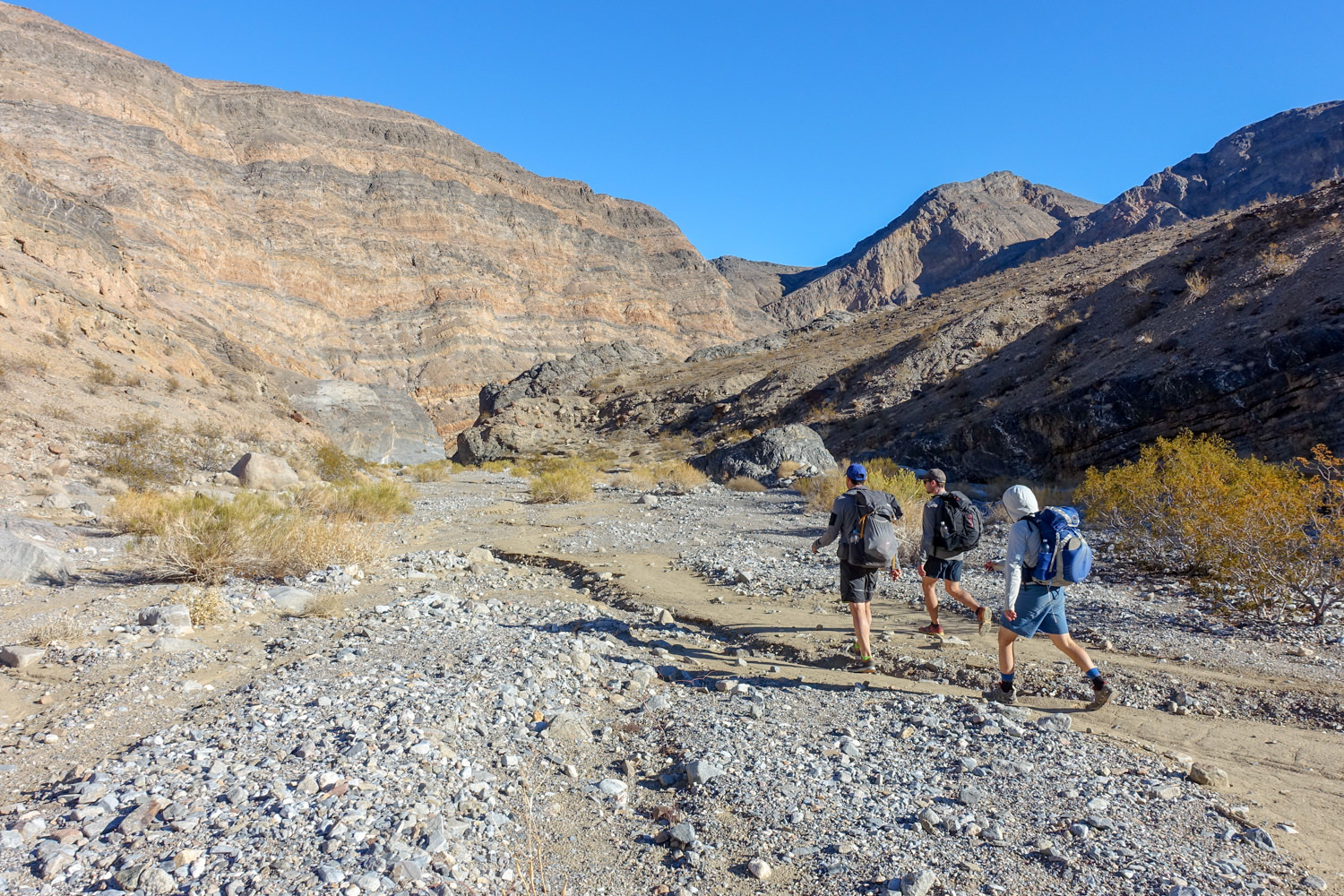
Route Description
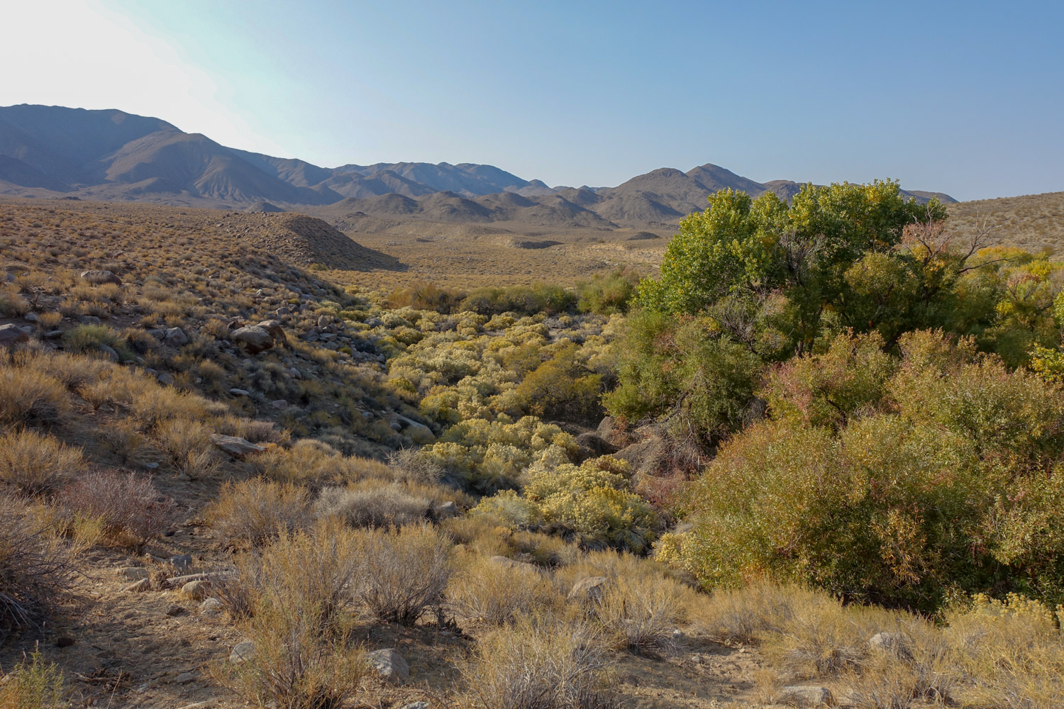
Most people hike the Cottonwood-Marble Canyon Loop in a clockwise direction, hiking along Cottonwood Canyon Road for the first 8 miles. After the this dirt road stretch, the route narrows from road to trail, and passes through a canyon, before reaching a grove of cottonwood trees. This is the location of one of three seasonal springs along this route, but it should not be relied upon (Cottonwood Springs 4 miles up the trail is much more reliable). This may be a good place to get water in fall, winter and spring, and to set up camp.
Hiking toward Cottonwood Spring, the trail gets rougher and makes its way up an easy slope to a steep canyon before entering an oasis of cottonwood trees. This is another good place to camp and the best water source along the entire loop. From here it’s 6 miles to Deadhorse Canyon, much of it across desertscape. Dig out the map and compass (or better yet, GPS), because while there may be signs (like footprints) that will point in the right direction, it’s tricky here.
Continue trekking up the valley with the mountains on your right. Head up the steep gully ahead to a low saddle that provides entry into Deadhorse Canyon. This is another confusing spot. To enter Deadhorse Canyon,drop into the next vegetated canyon, and hike a short ways (less than a city block) into it. Then head uphill to a saddle the north for a big view over Deadhorse Canyon and a large cottonwood tree in the valley below. From the saddle, turn left ( not right, like the NP GPX track says ) and head steeply downhill to the water drainage area. From here you can turn right and head down the drainage much more easily than the steep decent down the headwall to Deadhorse Canyon.
Shortly after reaching the large cottonwood tree at the bottom of the canyon, you’ll come across a tricky section of trail that has a 6-8 food drop (see photo gallery below). It may be easier to navigate this section without your pack, so take it off and have a hiking partner hand it down to you. There are some foot and hand holds in the rock that make it easier to get down, so take your time and be safe.
Marble Canyon, known for its beautiful distinctive narrows, and soaring walls (a reminder of similar places in Utah), can also be debris choked after storms and dangerous during them. Flash flooding is a potential danger, particularly in the spring and early fall. For many people Marble Canyon is considered the best part of the loop with easy grades, beautiful narrow canyons, and options to avoid the sand and gravel that dominates the area by staying on hard pack terra firma along the way.
Marble Canyon presents only one moderate challenge: a boulder blocks (dry pour-off) the canyon exit and a climb of the west ridge is required to get around it. Make your way through these canyons until you reach Marble Canyon Road. The final stretch through a wash to the end/start at the junction of Marble Canyon and Cottonwood Springs Road.
Getting there
From Barstow, California – Get on I-15 S from E Mountain View Street and Barstow Road and follow CA-58 W and US-395 N to Trona Rd for 59.5 miles. Turn right onto Trona Rd and follow it for 21.2 miles. Follow Trona Wildrose Rd and CA-190 E for 87.3 miles. Turn left onto Cottonwood Canyon Rd and drive 4.3 miles to Stovepiple Wells Campground.
From the Stovepipe Wells Campground – Drive west on Cottonwood Canyon Road. A high-clearance vehicle is recommended to reach the start of this loop. If you’re in a 4WD vehicle you can go about two more miles to knock off part of the rough washboard road that must otherwise be hiked for the next 8 miles.
It’s highly recommended that you use a GPS device on this route, as it can be tricky to navigate at times and getting lost would be disastrous. We use GPS phone apps like Gaia GPS and Topo Maps+ and they work great.
GPS Files From the National Park – (Full Trip): GPX (98 KB download). KML format (78 KB download). This GPX track is what we used and it worked great. The following downloads are all optional and unnecessary if you use the full trip download.
NOTE : There’s one one section on this GPX track that isn’t quite right. From the saddle overlooking Deadhorse Canyon (you can see one large cottonwood tree in the canyon below from the top), turn left (not right) from this saddle and head down to the water runoff drainage. From that point you can turn right and head downhill much easier that the route the GPX track would take you on.
Separated Road and Trek KML Tracks: Cottonwood Marble Road ( 6 KB download), Cottonwood Canyon Road (16 KB download), Marble Canyon Road (2 KB download). Cross Country Trek (39 KB download).
GPS Waypoints (less than 2 KB download each): Cottonwood/Marble parking for 2WD vehicles, chokestone obstacle , Deadhorse saddle traverse , Cottonwood Canyon camping area , Cottonwood Canyon , Cottonwood Canyon End Road , Cottonwood/Marble Canyon Road intersection , Cottonwood Saddle , Lemoigne Turnoff , Cottonwood Valley , Cottonwood/Marble Camp , Cottonwood Canyon Spring , Cottonwood Springs Camping , Cottonwood Springs , Deadhorse Canyon Camping , Deadhorse Canyon Dryfall , Deadhorse Spring , Dry Spring on Pass , end Marble Canyon Road , Lemoigne Canyon turnoff , Lower Marble Canyon Narrows , Marble & Deadhorse Canyon intersection , Middle Marble Canyon Narrows , rocky outcropping Cottonwood Canyon , saddle looking down Deadhorse , Upper Marble Canyon Narrows .
There are no designated campsites along this route, but you will surely see signs of previous camps. The best campsites tend to be around Cottonwood Springs and in Deadhorse Canyon with seasonal water flow and ample shade from the old growth cottonwoods that thrive in the area. But you can also camp anywhere out on the desertscape/playa between Cottonwood Springs and Deadhorse Canyon, and at the Marble Canyon entry point (trailhead).

POSSIBLE ITINERARIES
Two day itinerary.
TRAILHEAD Start/Finish: Cottonwood-Marble Canyon Junction
Day 1 – Hike clockwise to Cottonwood Springs (about 12 miles)
Day 2 – Get an early start for a long day continuing clockwise back to your starting trailhead through Marble Canyon (about 14.3 miles)
Note – You could also reverse this route and start with the longer day. Additionally, you could make this a great 3 day itinerary by stopping short of your car by a few miles and camping another night around the Marble Canyon trailhead.
Three Day Itinerary
Day 1 – Hike up Cottonwood Canyon to camp near Cottonwood Canyon Road end campsite near a seasonal spring. (8.5 miles)
Day 2 – Hike from Cottonwood Canyon to seasonal Deadhorse Springs. (9.5 miles)
Day 3 – Hike from Deadhorse Springs back to start. (8.3 miles)
Four Day Itinerary
Day 1 – Hike up Cottonwood Canyon to the seasonal spring near the end of Cottonwood Road. (8.5 miles)
Day 2 – Hike to Cottonwood Springs (3.5 miles)
Day 3 – Hike from Cottonwood Springs to seasonal Deadhorse Springs (6 miles)
Day 4 – Hike from Deadhorse Springs through Marble Canyon and back to your car (8.3 miles)
MAPS & GUIDEBOOKS
Below is a list of guidebooks and maps we’ve found helpful in planning our trips in Death Valley. In addition to planning with these resources, we recommend calling or visiting the ranger station in Death Valley to get any updates on current conditions.
Hiking Death Valley National Park: A Guide to the Park’s Greatest Hiking Adventures – This book includes detailed information about 57 of the best day hikes and extended backpacking trips in Death Valley. It includes GPS coordinates for the trailheads, mile-by-mile directional cues, rich narratives, and beautiful photographs.
Death Valley National Park Recreation Map – Tom Harrison Maps are famous for their beauty and accuracy. This map includes color-coded symbols and trails, mileages between trail junctions, latitude/longitude, UTM grids, contour lines, vegetation, and elevations at trail junctions.
National Geographic Trails Illustrated Map – Death Valley National Park – This map features all of Death Valley’s marked trails, including mileages between intersections, a list of backcountry roads and trails complete with descriptions, lengths, and starting points. The map base includes contour lines and elevations for summits. Hot weather tips, a temperature chart, regulations, and safety suggestions are included as well. It’s also printed on “Backcountry Tough” waterproof, tear-resistant paper.
Hiking Death Valley: A Guide to its Natural Wonders and Mining Past – This book offers in depth descriptions of each region of the park, meticulous maps, mileage tables, and some of the most useful trip descriptions found in any hiking guide.

Regulations
Visit this link to read about all of the regulations that apply to Death Valley National Park Service. We are not an official source on current regulations, so please consult the official website prior to your trip for frequent road closures. Below is a snapshot of important regulations to follow.
No campfires are allowed.
Being in an area posted as being closed for restoration, wilderness restoration, or rehabilitation is prohibited.
Walking on, climbing, entering, ascending, descending, or traversing any archaeological or cultural resource is prohibited. This includes all mine structures, features, and ruins (i.e. standing mill structures; aerial tram towers, terminals, and cables; ore bins; ore chutes; buildings; walls, gates, fencing, etc.).
Possessing, destroying, injuring, defacing, removing, digging, or disturbing a structure or its furnishing or fixtures, or other cultural or archeological resources, is prohibited. This includes all mine structures, features, and ruins (i.e. standing mill structures; aerial tram towers, terminals, and cables; ore bins; ore chutes; buildings; walls, gates, fencing, etc.
In non-designated campgrounds, group size is limited to 12 persons and no more than 4 vehicles, and/or 8 pack animals, and/or 4 vehicles. Groups larger than 12 must split up into smaller groups and must camp, hike, and eat at least a half-mile apart. Larger groups may request an exception to these limits from the superintendent under the terms of a special use permit.
Backpacking in Death Valley can be more challenging than a lot of places due to its arid environment. There are three seasonally reliable water sources along this route with flows that vary depending on the time of year. Of the three sources, Cottonwood Springs is the most reliable. All water sources here should be filtered or treated because giardia is present in this area. We highly recommend calling the Death Valley visitor center (760-786-3200) to ask about current water source conditions prior to your trip.
All hikers are different, but in general you should carry at least 4 liters of water per person per day. On very hot days you may want to drink 5-6 liters, but again, everyone’s different. We highly recommend bringing a trusty water bladder or two (we like Platy Bottles ) to carry water between sources.
For purification, we used a combination of Chlorine Dioxide pills and a Sawyer Squeeze on this loop, and we were happy with our choices. Check out our Best Water Filters list for more great options.
Seasonal Springs along this loop (clockwise):
Cottonwood Road’s end – 8.5 miles in
Cottonwood Springs – 12 miles in (the most reliable source)
Deadhorse Springs – 1/4 mile north of the large cottonwood tree at the bottom of Deadhorse Canyon (if you hit the 6-8 food dryfall you’ve gone too far) – 18 miles in

Cottonwood Springs
BEARS & FOOD STORAGE
Bears are not a problem in this area so there are no food storage requirements. That said, you should always protect your food against rodents and small critters, which will tear through your backpack or tent without hesitation. We recommend packaging all your food and scented products in a food storage container like an Ursack .
Gnats are only a problem in rare wet years near water sources. Otherwise, keep your tent zipped and your boots in a bag or in your tent to avoid encounters with scorpions.
BACKPACKING GEAR
We prefer lightweight backpacking because it’s more comfortable and it allows us to cover more ground with less effort. For recommendations on our favorite lightweight backpacking equipment, check out the CleverHiker Gear Guide and Top Picks page.
What To Pack
TENT: We used the Zpacks Triplex tent on this trip to keep our weight to a minimum. The Triplex is one of the top picks on our best lightweight backpacking tents list.
BACKPACK: We used the Katabatic Onni LiteSkin , Gossamer Gear Gorilla , and Osprey Exos backpacks on this trek. All three are lightweight, convenient, comfortable, and make our list of the best lightweight backpacking packs .
SLEEPING BAG: We used the Enlightened Equipment Revelation 10° and Therm-a-Rest Vesper quilts on this trip. They’re both lightweight, warm, and make our list of the best backpacking sleeping bags .
SLEEPING PAD : We used the Therm-a-Rest NeoAir XLite and Big Agnes AXL sleeping pads on this trip. They’re light, comfortable, warm, and make our list of the best backpacking sleeping pads .
COOKING SYSTEM: We used the MSR Pocket Rocket 2 stove along with our Snow Peak Mini Solo Cookset and Snow Peak Folding Spoon on this trek, all of which make our top picks gear list and best lightweight stove list .
WATER PURIFIER: We used Chlorine Dioxide pills and a Sawyer Squeeze as our water purification methods on this trip. Both methods work great and compliment each other for fast and efficient clean water. Check out our best water purifiers list for our other top recommendations.
SHOES OR BOOTS: We wore the Saucony Peregrine 8’s on this trail and they were excellent. If you prefer boots, make sure they’re lightweight and break them in really well before your trip. Here’s why we prefer hiking in trail running shoes: 5 Reasons to Ditch Your Hiking Boots . Also, here’s our top picks for the best backpacking footwear .
HEADLAMP: A small headlamp like the Petzl Actik is an affordable, bright, and lightweight option that we really like.
FOOD: When backpacking this loop you’ll have to carry all your food. Check out our Best Lightweight Backpacking Food Guide and our Best Freeze Dried Backpacking Meals for some of our go-to recommendations.
FOOD STORAGE : For this trip, we brought an Ursack to keep the critters out of our food. There are no food storage requirements for this area, but you should always store your food properly in the backcountry to keep it away from animals.
CLOTHING: Here are some of our favorite hiking/backpacking clothing items from our Top Backpacking Gear list .
1 Rain jacket shell – Marmot Pre-Cip / Rab Kinetic Plus
1 Pair of rain pants (optional) – Mountain Hardwear Stretch Ozonic
1 Down jacket – Patagonia Micro Puff Hoody
1 Fleece jacket (optional) – Extra warmth under your down jacket that will be warmer when damp and better to hike in.
1 Pair hiking pants -(we like PrAna Zion Stretch ) or running tights
1 Pair hiking shorts – Nike dri fit running shorts
1-2 Hiking t-shirts – Nike dri fit t-shirts
1 Long-sleeve shirt – Nike dri fit quarter zip
1-3 Pair underwear – ExOfficio boxer briefs or or ExOfficio women’s briefs
2-3 Pair socks (add thin sock liners if using boots) – Balega running socks for warm weather & SmartWool mountaineer socks for snow.
1 Pair long john bottoms – long john top optional for nighttime use.
1 Pair gloves or mittens
MAP &COMPASS: We hiked with a free paper topo map that we received from the Death Valley visitor center and it worked well. In addition, and more importantly for this loop, we always hike with a downloaded GPS app on our phone, like Gaia GPS , and make sure to download the GPX track .
FIRST AID KIT: Always bring a small personalized first aid kit. We use the Ultralight .7 Kit and add extras, like painkillers and personal medications.
SUN PROTECTION: Sunglasses (polarized recommended), sunscreen, and spf lip balm are an absolute must on any backcountry trip, especially this one.
POCKET KNIFE: We brought along a small Swiss Army Knife , which came in handy here and there.
OTHER ITEMS:
SMALL TOWEL: Nano pack towel is great.
CASH and ID
PERSONAL TOILETRIES
HAND SANITIZER: Always apply after using a bathroom and before eating.
WET WIPES: These can be useful for cleaning up after hiking.
INSECT REPELLANT: At higher elevations insects weren’t a problem for us at all. For lower elevations, a 1oz bottle of DEET will do the trick.
CAMERA: The Sony RX100 is our go-to camera for lightweight backpacking.
More Cottonwood Marble Canyon Loop Photos

Final Thoughts
This route in Death Valley is a really fantastic backpacking loop. We hope this guide helps you plan an awesome, safe, and memorable adventure. As always, please leave us a comment below if you have any recommendations, questions, or suggestions.
For more popular CleverHiker content, check out the following links:
CleverHiker Gear Guide
CleverHiker Top Gear Picks
Essential Trail Skills Videos
Lightweight Gear Foundations Videos
Some of the links on this page are affiliate links, which means we may receive a modest commission if purchases are made through those links. This adds no cost to our readers and helps us keep our site up and running. Our reputation is our most important asset, which is why we only provide completely honest and unbiased recommendations.
- Media Mentions
- Press Releases
- Quick Facts
- Testimonials
- Bulletin Board
- Newsletter Sign-up
Death Valley Hiking Tour
Dates unscheduled, (contact us to request dates).
Family Friendly
Double booking, single booking, roommate rebate.
Includes all lodging, all meals, van shuttle between Las Vegas and Death Valley, park entrance fees, leaders, tour maps and narratives.
Assembly Point
Las vegas, nv.
Timberline van shuttle between Las Vegas and Death Valley is included prior to and following tour.
Not included: Airline service to Harry Reid International Airport , Las Vegas, NV, Guide Gratuity.
Meeting Time
Hotel 8:30 am, drop-off time.

“Carol and George are both fantastic guides!” Death Valley hiker
Death Valley National Park
Death Valley National Park has an instantaneous emotional impact on everyone who sees it. That initial view from Zabriskie Point across the vastness of the valley floor to the distant Panamint Peaks rising from the valley clad in an unmistakable mantle of snow is unlike anything that you have ever experienced in a hiking trip.
Death Valley Guided Hiking Tour
Spectacular though this view may be, it reveals nothing of the intrigue of Death Valley. Several days of hiking into just a few of the nooks and crannies of Death Valley confirmed for us why we choose to hike rather than do bus tours. You won’t believe the hidden treasures that await you on this Death Valley Hiking Tour – the startling colors of Mosaic Canyon , the improbability of a waterfall in Fall Canyon and the narrows of that canyon above the fall, the Ubehebe Volcanic Crater , and the breathtaking views from its rim, to name a few. Although the region can easily reach 40°C (104°F) in the summer months, our visit in late February will have pleasant temperatures of 20°C (68°F), and the winter blooms will dazzle us with an array of desert golds that will surpass any prior images of a desert in bloom. The reality is—when you’ve chosen to visit a region that embraces the lowest point in the Western Hemisphere that is located only 80 miles from the highest point in the “Lower 48,” you need to expect the unexpected. Death Valley does not disappoint.
See Detailed Death Valley Itinerary Here!
Contact our hiking experts to find out more about the Death Valley group hiking tour! Explore the full tour calendar here!
Total Distance: 32 miles
Inn highlights.
- The Oasis at Death Valley
Related Tours

Death Valley National Park Cycling Tour
CHOOSE YOUR DATES
Death valley n.p. hiking tour - 6 day self-guided.
Timberline Adventures / 214 Mohawk Dr. Boulder, CO 80303 / 1-800-417-2453 or 303-664-8388 / Fax: 303-664-8395
Routes, mileage and accommodations are subject to change due to safety, road/trail conditions, weather and availability.
© 2017 Timberline Adventures. All Rights Reserved. | Web Design by VistaWorks
You are using an outdated browser. Please upgrade your browser or activate Google Chrome Frame to improve your experience.

- Trip Styles
- Destinations

- Trip Destinations
- California Hikes & Tours
- Death Valley Hiking Tours
Death Valley Inn Based Tour
Las vegas, nv, trip highlights.
- Wonderful Hikes
- Casual or Premier Lodging
- Salt Flats & Sand Dunes
- Alpine Hike with BIG View
- Colorful Volcanic Deposits
- Mining & Pioneer History
- Narrow Canyons & Petroglyphs
Description
With secluded mountain canyons and alpine peaks towering over surreal, below-sea level salt flats, Death Valley National Park is a land of contrasts that captivates the imagination. Our Inn-based Death Valley Tour allows you to enjoy the best backcountry trails in the park while returning to the comfort of contemporary lodging and relaxing restaurant meals each evening.
Death Valley—the largest national park in the contiguous United States—is 93 percent untrammeled wilderness, making it a paradise for hikers and nature enthusiasts. Discover narrow canyons, vast dune fields, ancient lava flows, high alpine forests, scenic mountains, and the rich history of the American West. After spending your days exploring this diverse landscape, enjoy your evenings in historic Furnace Creek lodging where you can clean up, eat a fine dinner, and relax by a crackling fire under incredible starlight.
NEED TO KNOW: WINTER TRIPS
If you want to get out hiking this winter, Death Valley is a great place to do it! Winter temperatures are wonderful for hiking and enjoying being outdoors and surrounded by vast wilderness. We invite you to read more about Death Valley climate info .
$3320 Per Person
$3015 per person, $1025/620 single supplement.
The single supplement guarantees your own room. If you would like to forego the single supplement, you can request to be paired with a roommate of the same gender. If we are unsuccessful in pairing you with a roommate, the single supplement will apply.
DIFFICULTY LEVEL 2
Scale of 1-5. 1 is least difficult; 5 is most difficult
Hiking Distances:
Backpack Weight:
Max Daily Elev. ↑↓:
Heights Exposure:
Please Note: Terrain, Elevation Gain and Heights Exposure ratings reflect the section or day of the trip with the maximum difficulty of each. Much of the trip is at easier levels. See the trip itinerary for more detailed information.
PHYSICAL DEMANDS OF THIS TRIP
- Hiking uphill or downhill with a 8-12 lb backpack for 5-7 hours
- Maintaining balance and footing on moderately rugged terrain (more rugged on the Wildrose Peak hike)
- Hiking with occasional, moderate heights exposure
SOLITUDE LEVEL 3
1 least solitude, 5 most solitude
We rate this Death Valley hike a solitude 3. You can expect hours of solitude at a time while hiking.
- Utah Sales Tax
UTAH SALES TAX
Utah is the only state we are based in that charges sales tax to outfitters and guides. The sales tax is based on the St. George, UT municipality rates, which are adjusted occasionally but are in the 6-7% range. For all of our hiking and backpacking tours that originate from our St. George, Utah base (Utah, Joshua Tree and Death Valley trips), the sales tax will be applied automatically to your payments. Feel free to call us at 1-800-715-HIKE (4453) with any questions!
Private Trips

Travel in perfect company by booking a private trip exclusively for your group!
Our sliding scale for private trips is based on the final number of guests in your group. Rates are per person and do not include sales tax, national park fees or guide gratuity. The final rate is based on the actual number of guests on the trip and may adjust based on cancellations or additions.
Please Note: you can also enjoy a private trip at our normal scheduled rates by filling any empty tour to capacity. However, if group members drop from the tour those spots will automatically become available on our website for instant booking. By purchasing a private trip at the rates listed below, your trip will remain exclusive to your group regardless of cancellations.
Private Rates FOr This Trip
- 2 People: Rate x 2.5
- 3 People: Rate x 2
- 4 People: Rate x 1.5
- 5+ People: Rate x 1.15
*all rates are per person and single supplements apply
- Minimum 2 Guests
Minimum 2 Guests
Minimum of 2 guests.
If a trip does not reach the minimum number of guests, you may choose to transfer to another trip date or another trip, be refunded your payments in full, or you may have the choice to pay a supplemental fee to run the trip with fewer guests. We make the final determination for these trips 4-6 weeks before the departure date, and notify guests of changes and options immediately.
Learn About Our Private Trips
- Shuttle to Death Valley: 2.5 hours
- Hiking Mileage: 5 miles
- Elevation Gain/Loss: 680 feet
- Accommodations: Inn at Furnace Creek (Premier) or Ranch at Furnace Creek (Casual)
This multi-day Death Valley hiking trip begins with a morning pick up from the Tuscany Inn and Suites in Las Vegas, Nevada. We’ll depart Vegas and embark across the fabled Mojave Desert’s basin-and-range landscape. Upon entering Death Valley National Park, we will be treated to morning views of the Badlands: jagged hills dazzlingly colored by volcanic metals. At the edge of the Badlands, we will walk to the top of Zabriske Point where we’ll first gaze upon Death Valley and the towering Panamint Mountains.
After a quick stop at the Furnace Creek Visitor Center, we’ll head to the trailhead of Golden Canyon and Gower Gulch: a classic Death Valley hiking loop that takes us deep into the Badlands of the Amargosa Mountains. After a hilltop lunch with panoramic views, we’ll hike down into the water-carved Gower Gulch which will spill us out onto a slanted desert landscape at the edge of Death Valley itself.
Time allowing, we may stop at one of many historic points of interest near Furnace Creek before settling in at our lodging where we’ll enjoy a fine dinner at the historic dining room of the Inn at Death Valley.

- Drive Time: 3 hours
- Hiking Mileage: 9 miles
- Elevation Gain/Loss: 2000 feet
After an early breakfast, we’ll head deep into the very spine of the park, the tree-clad Panamint Mountains, where we’ll take-on the 9000-foot Wildrose Peak. This rugged mountain hike offers a heart-pounding physical challenge with an equally rewarding summit. At the trailhead are the historic Charcoal Kilns: enormous stone domes used for smoking out wood fuel for Old West mining operations. With surprisingly cool temperatures, our hike will take us into a rich juniper and piñon forest as we climb the east slopes of Wildrose Peak. At the summit, we’ll have absolutely breathtaking views of Death Valley, Panamint Valley, and the snow-streaked Sierra Nevada Range on the western horizon.

- Drive Time: appx 5 hours
- Hiking Mileage: 4+ miles
- Elevation Gain/Loss: 635 feet
A welcome easy day after yesterday’s ascent, today’s hike takes us onto the peaceful Mesquite Sand Dunes and to a miracle in the desert — the stunningly beautiful Darwin Falls. We’ll drive west past the Devil’s Cornfield and stop for a quiet hike on the renowned Mesquite Sand Dunes. Atop the dunes, we’ll enjoy sweeping views of several mountain ranges, and get a greater appreciation for what the valley looked like when it was a glaciated lake during the cool and wet Pleistocene.
After the dunes, we’ll drive further west to visit one of the most tremendous sights in Death Valley National Park. Darwin Falls is an anomaly — a spring-fed waterfall of marvelous beauty in the driest place on earth. Our easy, two-mile hike to the falls is not to be missed during our time in Death Valley National Park. After the falls, we’ll enjoy a splendid dinner and make the return drive to Furnace Creek.

- Hiking Mileage: 4-7 miles
- Elevation Gain/Loss: 200-500
- Shuttle to Las Vegas: 2.5-3.5 hours
For our final day in Death Valley, we’ll hike one of several mountain canyons of the Amargosa Range. Desolation Canyon, Sidewinder Canyon, Virgin Spring Wash, and Kaleidoscope Canyon each offer their own taste of sublime Death Valley wilderness. We’ll have lunch on the trail or, if time allows, atop the expansive vista of Dante’s View—the best overlook of Death Valley itself—while celebrating and reflecting on our amazing journey.
Please Note : We always do everything in our power to follow the set itinerary, however it can change occasionally based on temporary access restrictions, weather, lodging/campground availability, guest ability/injury, natural events like fires and flooding, and other potential causes. Normal terms and conditions apply to trips with itinerary changes.
Trip Dates & Booking
Trip dates & booking.
Click on a date to register. You can also click here to request new dates or book through customer service.
AVAILABLE TO BOOK
This trip is available and bookable online! Click on the date to register now or contact us online to book through our award-winning customer service team!
This trip has 1 or 2 spots remaining and is bookable online! Click on the date to book now or contact us online to book through customer service.
REQUEST A RESERVATION
This trip is exclusively booked through customer service due to logistics with lodging, permits, staffing, availability, or something else. Please contact us online or call us at 800-715-HIKE (4453) to request a reservation.

Don't see your dates? Call us! We may be able to add new trip dates.
Trip details, what's included.
- 3 nights of double occupancy lodging at Furnace Creek Resort or equivalent Death Valley hotel (single occupancy requires an additional single supplement)
- Use of trekking poles and a day pack
- All meals are included from breakfast the first day through lunch on the last day
- Trained hiking guide(s) with years of personal wilderness and hiking experience, medical certifications, and a passion for leading people into breathtaking landscapes. See Guide Bios .
- Comprehensive, roundtrip transportation from your hotel in Las Vegas and back
- All necessary entrance fees and permits
- Emergency equipment including a company-issued first-aid kit and communication device (InReach Explorer or satellite phone)
What's Not Included
- Clothes, raingear, and footwear ( see recommendations )
- Sunscreen, toiletries and personal items
- Water bottles and a headlamp or flashlight
- Alcoholic beverages
- Guide gratuity (industry recommendation is 10-20% of trip cost)
Click here to see a printable, downloadable trip information packet with more detailed guidance about what to pack.
Meals: What to Expect
This Death Valley hiking tour features a combination of restaurant meals and meals prepared by your guide.
We provide breakfasts and lunches for the trip. For optimal taste and energy, we supplement all our meals with spices, herbs, oils, cheeses, butter, sugar, and fruits and vegetables. In addition, we provide you with with an assortment of trail mix, snacks, and dried fruits to eat at your own discretion.
We regularly accommodate vegan, vegetarian, kosher and non-gluten diets and will make adjustments for food allergies. These and other special dietary requests may require an additional fee.
Gear We Provide
We provide all group gear which includes the following:
- Deuter or Osprey backpacks
- Leki trekking poles
- Company-issued first-aid kit
- Emergency communication device(s)
Guest Packing List
When you register for this tour you’ll receive access to a printable, downloadable trip information packet with a detailed packing list specific to this trip ( click here to see it now.) All trips require a sturdy pair of hiking shoes or hiking boots, rain gear, a recommended clothing system, a headlamp or flashlight, a hydration system (water bottles and/or bladder) and other items specific to each trip.
Trip Logistics
How do i register.
Reserve your spot today! In the Trip Dates & Booking section of this page, the green and red dates are bookable online by simply clicking on the date, and blue dates must be booked through our customer service team for a variety of possible reasons. To email our customer service team, you can click here to get the ball rolling. Our adventure consultants will confirm availability, and if you’re ready to register we’ll email you a link to a registration profile. You’ll have 72 hours to complete your profile (and that of any dependents) and pay the deposit.
Feel free to call us for more info – we’re here 7 days a week!
Where Do We Meet?
This trip originates from Tuscany Suites and Casino in Las Vegas, Nevada. Your guide will be in contact approximately 10 days before the trip start date to coordinate the pre-trip orientation, which will be at 5:00 PM at a hotel in Las Vegas. Your guide will then pick you up at your hotel the next morning for transport to the trailhead. For Private Death Valley Tours your guide will meet you at your hotel in Las Vegas at an agreed upon time.
Click here to see a printable, downloadable trip information packet with more detailed guidance about flights, shuttles, recommended lodging and more.
Travel to Las Vegas
Las Vegas’ McCarran Airport is one of the most easily accessed destinations in the country. Many major cities in the United States and internationally offer direct flights into Las Vegas. A company named Airline Shuttle (1-888-554-1156) can help you with economic transport to most hotels. Taxi cabs run about $40 to downtown, and the city is also Uber- and Lyft-friendly.
Start/End Times
Your guide will inform you of the first day’s pick-up time at the orientation meeting. Generally, you can expect it to be between 5 and 8 am, although the exact time will depend on current weather and road conditions. We will drop you off at your hotel on the final day normally before 5 PM (this time is not guaranteed, as a variety of circumstances can influence our exact return time).
Safety Precautions
Your safety is our top priority. Our hiking tours are led by professional hiking guides, all of whom are wilderness-certified first responders or EMT’s, each with years of guiding and wilderness experience. Guides adhere to standardized risk management protocols in case of any potential or actual incident, and all tours carry an emergency communication device and comprehensive first-aid kit. Additionally we have a “24/7” system through which guides or guests can reach Wildland support personnel at any time.
If you have any further questions about safety, please contact us at 1-800-715-HIKE (4453) for more information.
Essential Eligibility Criteria
Essential Eligibility Criteria (“EEC”) have been specifically identified to help you understand the skills and abilities necessary to participate on each Wildland trip, and they apply uniformly to all potential trip participants, irrespective of the presence or absence of any disability.
Once you identify a trip in which you may be interested, please carefully review the EEC and itinerary details. If after reviewing the EEC that apply to your desired trip, you determine you need an accommodation in order to meet the EEC, please contact us prior to registering to discuss your requested accommodation.
The EEC exist for your own safety and the safety and enjoyment of all participants. If you are unable to meet the EEC for the trip, with or without an accommodation, you are not eligible for that trip. If you register and arrive for a trip for which you do not meet the EEC, you will be disqualified from participation on the trip and will be dismissed or evacuated from the trip without a refund.
Guide Working Parameters
Guides are required to take 8 hours off each 24-hour period to sleep, recuperate, take personal/down time…etc. In addition, as part of the 8 hours off they must sleep/rest or be in their tents/rooms uninterrupted for a minimum of 5 hours each night. We ask guests to respect these requirements and to not interrupt guides’ off time and sleep time unless there is a true emergency.
Age Restrictions
Age restrictions on this trip are as follows:
- 12 and older to join scheduled tours (mixed groups)
- 5 and older to join private tours, with final approval and specific logistical requirements (such as porter or stock assist) determined on a case by case basis
Weather in Death Valley
Death Valley encompasses an area with extreme elevation and climate variations. It is home to the lowest point in the United States: Bad Water Basin at 282 feet below sea level. Its highest point, Telescope Peak, is 11,049 feet high, a 11,331 ft difference!! Most of our trips focus on the lower elevations, and feature comfortably moderate winter temperatures, and warm-hot Spring/Fall temperatures. To be fully prepared, please follow the recommended clothing list closely (this list comes as part of your trip packet when you register). Read below for average high and low temperatures in the lower sections of Death Valley:
- Accommodations

OASIS AT DEATH VALLEY
Premier Option : A deluxe resort built in 1927, The Inn at Furnace Creek is a four star, elegant resort that takes wonderful care of its guests. After our hikes you can relax near the spring-fed pool, walk around the stunning palm gardens, or rest up in your exquisite room. (pool, spa)

RANCH AT FURNACE CREEK
Casual Option : The Ranch at Furnace Creek features casual, family-oriented accommodations for the more price conscious traveler. After our hikes you can stroll around the Old West-themed grounds, enjoy a dip in a spring-fed pool, or relax in your quiet, recently renoovated room. (hot springs pool)
*These exact accommodations are not guaranteed. In some instances alternative accommodations of similar quality and location may be used
Trip Reviews
Average customer ratings:.
- 5.0 (21 reviews)
- Most recent
Great Time Hiking
We had a great time hiking in Death Valley but a break in the water line left us without water in our cabins or restaurants. Not WT fault and Carm, our guide did a great job adapting and took us out for dinner outside the park. We weren’t notified of any free water and everyone in the two hotels had to buy water. The outhouses weren’t provided until the day after.
Death Valley needs to be on your bucket list.
Death Valley needs to be on your bucket list. So much diverse beauty, almost a senses overload! Our guide, Carm, was super flexible on food needs, physical abilities and unplanned road closures due to extreme weather previous to our trip.
Maryalice W
Wildland trekking’s #1 fan.
If it were possible to rate 10/5 stars I would. This was my third and longest hike with Wildland. As was the case with my previous two hikes, all of my expectations were exceeded. My siblings and I chose the Death Valley Inn-based hike as joint birthday gifts to each other. The shared hike allowed us to revisit a lifetime of memories while creating countless new ones. Wildland’s website contains all the information required to properly prepare for hikes. From weather conditions, to packing lists, to suggested training; hikers are provided with all the tools needed for a safe and enjoyable hiking experience. Having meals and hiking gear included in the package price was luxurious. We didn’t have a care in the world except for aching joints and sand in our eyes. Secondly, our guide, Daniel Wingert was PHENOMENAL! And by phenomenal, I mean (insert any possible affirmative adjective). My siblings and I joked that if we’d said “jump”, Daniel literally would have replied, “How high?” Daniel was perfectly prepared, organized, flexible, knowledgeable, entertaining and an all-around #hellofaguy! We loved him so much that we wrote a song for Daniel. We’ll let him share that if he chooses. Within our group of six hikers, I was the only one following a plant-based diet. In preparation for our hike, Daniel called the chef at our Death Valley Inn to make sure he/she could accommodate a vegan. Daniel shopped for and prepared unique and delicious vegan options for all of our gourmet trail lunches. Every morning, before leaving his room, Daniel brewed a steaming thermos of Kona blend coffee. What a treat it was to enjoy delicious piping hot coffee with our trail lunches and post hike. When a restaurant didn’t have soy milk for my coffee, Daniel said, “No problem, I’ll get some from the van.” We joked that Daniel’s Wildland Trekking van was just like Mary Poppin’s purse. He had EVERYTHING! When our inn didn’t have peanut butter for my English Muffin, Daniel quietly left the table, returned to his room… at another resort… and brought back a jar of Skippy. Talk about above and beyond! The first night at the inn found us without power or internet. Not only did Daniel call nearby towns to find a restaurant with power, he also made sure they had vegan menu options. Further, he assured me, “I have food for you in the van if you can’t find something on the menu.” The only suggestion I have is that when hikers upgrade to premium lodging, the guide should stay in the same place. Further, the guide’s meal preparation would be much easier if he/she had a suite with a kitchenette. (No Daniel did NOT tell me to write that). I just cannot imagine meal prep for a group of six hikers in a standard hotel room. Still Daniel made it appear effortless. I must be Wildland Trekking’s #1 fan! At one trailhead, we encountered a couple who was seeking a unique national park experience. With Daniel at my side, I presented a glowing monologue about the features and benefits of hiking with Wildland. When I finished, the couple took a picture of the Wildland logo on the van door so they could find the company online.
See All Guest Reviews!
Related trips, you might also like....

Best of Death Valley and Joshua Tree

Women’s Death Valley Basecamp Tour

Death Valley Basecamp Tour
- Similar Trips
- day by day itinerary
- logistical and travel information
- gear and clothing lists and more
Leave a Reply Cancel reply
Your email address will not be published. Required fields are marked *
First Name & Last Initial *
Save my name and email in this browser for the next time I comment.
wildland Wires
Sign up to receive our exclusive Wildland Wire emails and stay up to date with Wildland Trekking's promotions, discounts, contests, outdoor tips and tricks, trip reports and more!
COMMENTS
Badwater Salt Flat Length: 1 mile (1.6km) out and back trip to edge of salt flat. 5 miles (8km) each way to the other side. Time: Average hiking speed is 2 mph (3.2 km/h), make your own adventure! Difficulty: Easy to difficult depending on length. It is flat. Do not attempt when it's hot! Elevation Gain: Flat Location: Badwater Road 30 minutes (17 miles/27km) south of Furnace Creek.
Area: Death Valley Hiking Tours . Trip type: Camping Hiking Tour . A Wildland Trekking basecamp tour is an incredible way to have an adventurous outdoor experience of world renowned national park and wilderness destinations while hiking with only a light daypack and sleeping soundly in comfortable, vehicle-accessible camps. Led by expert hiking ...
Where to Stay When Hiking in Death Valley. Luxury: The Inn at Death Valley. Mid-range: Panamint Springs Motel & Tents. Budget: Camp in Death Valley. Map Of Best Hikes In Death Valley National Park. 15 Best Death Valley Hikes. Zabriskie Point. Badlands Loop. Golden Canyon - Gower Gulch Loop.
Distance: 11.7-mile out-and-back. Elevation Gain: 3,101 feet. Difficulty: Difficult. The tallest peak in Death Valley National Park, Telescope Peak, is worth a hike and is easily done as a backpacking trip. Unlike most other options on this list, the hike to Telescope Peak follows a designated trail the entire way.
If you're looking for an adventurous (and easy) hike at Death Valley National Park, this one fits the bill. We saw a lot of families hiking with kiddos and everyone seemed to be having a great time - which is no small feat with kids. Darwin Falls is a must for all first time visitors. #4. Artist's Drive.
Backpacking in Death Valley National can be challenging, but the opportunities for experiencing solitude, sweeping vistas, dark night skies, and awesome geology abound within the three million acres of designated Wilderness in the park. There are few established trails in the park, but hikers can follow canyon bottoms, open desert washes, alluvial fans, and abandoned dirt roads to get around.
If you are planning a hiking trip to Death Valley National Park, read on to learn about the best Death Valley hikes, plus some tips for hiking in the desert park! Zabriskie Point Hike. Difficulty: Easy Length: About 0.4 mile, out and back Elevation gain: About 50 feet Time: 0.5 - 1.0 hour (longer if you want to take photos)
Shuttle to Death Valley: 4 hours; Hiking Mileage: 8.5 miles; Elevation Gain: 1300 feet; This multi-day Death Valley hiking trip begins with pickup from the Tuscany Inn and Suites in Las Vegas, Nevada and transportation to our trailhead. Upon entering Death Valley National Park we'll stop at the Furnace Creek Visitors' Center to pick up our ...
Fall Canyon. Fall Canyon is a 6 mile out and back hiking trail in Death Valley with 2,460 feet of elevation gain. It is located 11.9 miles north of CA-190 on Scotty's Castle Road. The trailhead is located 2.7 miles down Titus Canyon road, an unpaved road that is typically passable by sedans.
The Salt Creek Interpretive Trail is down a short dirt road and is 12 miles away from Stovepipe Wells and should take about 18 minutes to drive to. Alternatively, it is 15 miles north of Furnace Creek and should take about 22 minutes. This trail is in between a lot of the other Death Valley hikes, so is easy to add on.
The Mahogany Flat Campground is located at the trailhead and is the ideal place to spend the night before making this hike. This will give you time to acclimate to the high elevation. This is pretty important as you start off hiking at 8,000 feet to the highest point in Death Valley at 11,049 feet in elevation.
Panamint Dunes. This 8-mile round-trip hike takes you out to the most pristine dune field in Death Valley. "There are seven different dune fields in Death Valley," explains Arnold, "but this one is the most spectacular.". The Panamint Dunes are on the side of a mountain and the hike offers a great view Panamint Valley's broad span.
Hiking Death Valley National Park: A Guide to the Park's Greatest Hiking Adventures - This book includes detailed information about 57 of the best day hikes and extended backpacking trips in Death Valley. It includes GPS coordinates for the trailheads, mile-by-mile directional cues, rich narratives, and beautiful photographs.
The Death Valley/Joshua Tree Inn to Inn was my first guided hiking trip and I was totally blown away! Our amazing guide Samantha showed us all the best of these spectacular parks. Every day was a fun and unique adventure, complete with delicious food (both on the trail and at dinner out) and lots of laughs and camaraderie.
Shuttle to Death Valley: 2.5 hours; Hiking Mileage: 5 miles; Elevation Gain/Loss: 680 feet; Accommodations: Campground at Furnace Creek, Stovepipe Wells, or Emigrant Pass; This multi-day Death Valley hiking trip begins with a morning pick up from the Tuscany Inn and Suites in Las Vegas, Nevada. We'll depart Vegas and embark across the fabled ...
Day 1. Group assembles in Las Vegas early morning; van shuttle to Death Valley National Park; hike Sand Dunes (2 miles); overnight at the Oasis. 2. Day 2. Hike Willow Spring Canyon (5 miles); visit Badwater; hike Natural Bridge (3 miles) 8. Day 3. Hike Mosaic Canyon (4 miles), Salt Creek (2 miles) 8.
Shuttle to Death Valley: 2.5 hours; Hiking Mileage: 5 miles; Elevation Gain/Loss: 680 feet; Accommodations: Inn at Furnace Creek (Premier) or Ranch at Furnace Creek (Casual) This multi-day Death Valley hiking trip begins with a morning pick up from the Tuscany Inn and Suites in Las Vegas, Nevada. We'll depart Vegas and embark across the ...