- North America

Maps of Alberta

The Province of Alberta, located in Western Canada , encompasses diverse geographical features that contribute to its unique character. Bordered by British Columbia to the west, Saskatchewan to the east, the Northwest Territories to the north, and the U.S. state of Montana to the south, Alberta's geography spans an area of approximately 255,541 square miles. This vast region comprises several distinct landscapes, such as the Rocky Mountains, prairies, boreal forests, and parklands, each with ecological significance.
In the western part of Alberta, the Canadian Rocky Mountains dominate the landscape, forming a dramatic backdrop to the province. These mountains contain some of the highest peaks in Canada, such as Mount Columbia, which rises to 12,293 feet. The Rockies are a major attraction for tourists and adventurers, offering hiking, skiing, and mountain climbing opportunities. In addition, the region holds five national parks, including Banff and Jasper, which protect the pristine alpine environment and provide a haven for diverse wildlife.
To the east of the Rockies, the Foothills region transitions from the mountains to the flatlands. This area features a mix of forests, rolling hills, and grasslands, providing essential habitats for many species. The Foothills also contain rich natural resources, such as coal, oil, and natural gas, significantly contributing to Alberta's economy.
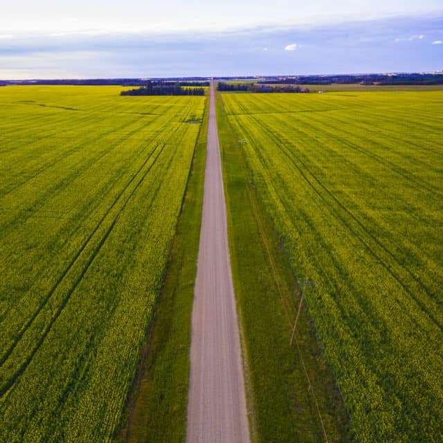
Moving further east, the Alberta Prairies dominate the landscape, characterized by vast expanses of grasslands and fertile agricultural lands. The province's prairies, part of the larger Great Plains ecoregion, support a diverse array of plant and animal life. This area experiences a semi-arid climate, with long, cold winters and short, warm summers, making it suitable for the cultivation of cereal crops, such as wheat and barley. The Prairies also host numerous wetlands, which serve as vital nesting grounds for migratory birds and play a crucial role in maintaining the region's ecological balance.
The Boreal Forest, stretching across northern Alberta, constitutes one of the largest contiguous areas of this unique ecosystem in the world. This vast expanse of forest, characterized by coniferous trees, such as spruce, pine, and fir, and interspersed with wetlands and lakes, supports an incredible variety of plant and animal species. This region plays a critical role in carbon storage and acts as a buffer against climate change.
The Parkland region, located in central Alberta, serves as a transition zone between the Boreal Forest and the Prairies. This area contains a mix of aspen forests, grasslands, and wetlands, providing habitats for a diverse range of flora and fauna. The Parkland region supports extensive agriculture, particularly livestock farming, and is home to several of Alberta's major cities, including Edmonton, the provincial capital.
In terms of hydrography, Alberta contains numerous rivers and lakes that shape its landscape and ecology. The province's two major rivers, the North Saskatchewan River and the South Saskatchewan River, flow eastward from the Rockies, eventually joining to form the Saskatchewan River . These rivers play an essential role in providing water for agriculture, industry, and domestic use, as well as supporting a rich array of aquatic life.
Provinces Map

The Canadian Province of Alberta is administratively divided into several different types of local governments such as, the urban municipalities (which includes cities, villages, towns, and summer villages); rural municipalities (which include counties/municipal districts, special areas, and improvement districts); specialized municipalities ; Métis settlements , Indian reserves and many unincorporated communities (which include hamlets, a townsite and urban service areas).
Currently, Alberta consists of 19 cities, 107 towns, 81 villages, 51 summer villages, 6 specialized municipalities, 63 municipal districts, 7 improvement districts, 3 special areas, 389 hamlets, 2 urban service areas, and 1 townsite. In addition to these, there are a total of 8 Métis settlements – which are rural areas that are currently inhabited by Alberta’s indigenous Métis people. About, 6,566.6 sq. km of total land area in Alberta is occupied by Indian reserves.
With an area of 661,848 sq. km, Alberta is the 6 th largest and the 4 th most populous Canadian province. Located in the heart of the Edmonton Capital Region and on the North Saskatchewan River, is Edmonton – the capital and the 2 nd largest city of Alberta. It serves as the administrative, cultural, economic, and educational center of Alberta. The city hosts various year-round festivals and has therefore been nicknamed “Canada’s Festival City” . The city of Edmonton is the northernmost among all the major Canadian cities and is often referred to as the “ Gateway to the North” . Situated in the southern part of Alberta near the confluence of Bow and Elbow rivers is Calgary – which serves as the largest and the most populous city of Alberta.
Where is Alberta?

The Province of Alberta is located in the west-central part of Canada, in the Continent of North America. It is geographically positioned in the Northern and Western hemispheres of the Earth. Alberta is a landlocked province that is situated in the Prairies region of Canada. It is bordered by the other Canadian Provinces of British Columbia in the west; by the Northwest Territories in the north; and by Saskatchewan in the east. In the south, the 49 th parallel north latitude forms Alberta’s international boundary with the US State of Montana.
Regional Maps : Map of North America
Outline Map of Alberta

The above blank map represents the Province of Alberta, located in the west-central part of Canada. The above map can be downloaded, printed, and used for geography education purposes like map-pointing and coloring activities.

The above outline map represents the Province of Alberta, located in the west-central part of Canada.
This page was last updated on March 16, 2023
Latest by WorldAtlas

7 Delightful Towns to Visit in Maine

7 Cutest Small Towns In Oklahoma To Visit In 2024

8 Most Inviting Towns in Missouri

Arizona's Best Small Towns for a Weekend Escape

8 of the Most Hospitable Small Towns in Florida's Emerald Coast

7 Coolest Towns In New Mexico For A Summer Vacation In 2024

11 Adorable Small Towns In the Poconos

Lambton Shores, Ontario: Exploring Nature and Community
Alberta Tourism Information
Why visit alberta.
Alberta , the largest of Canada’s three prairie provinces , contains a large portion of the Rocky Mountains and most tourism to the province centers around visiting the beautiful parks that surround them. The province’s two main cities, Calgary and Edmonton , are Canada’s largest outside the Toronto-Montreal-Vancouver axis, though they’re much less popular as tourist destinations. The larger city, Calgary, is generally acknowledged to contain more to see and do, though Edmonton contains a few famous attractions, as well.
Orientation
Most Albertans live in either Calgary or Edmonton and the cities are about three hours apart, with Calgary in the south and Edmonton in the north. The Rocky Mountain region is on the province’s far west, along the border with British Columbia . Everywhere else is largely rural, home to small farm towns and oil fields.

Lake Louise in Banff National Park. kavram/Shutterstock
The rocky mountain parks.
The most iconic tourist destination in Alberta — and possibly the entire country — is the beautiful Banff National Park and its emerald-green Lake Louise . Containing over 6,000 square kilometers of unspoiled Rocky Mountain scenery, Canada’s most popular outdoor resort is home to virtually every activity you could imagine, with over 1,000 km of hiking trails, a dozen campgrounds, numerous ski hills, a 27-hole golf course , three hot springs, and a wild river (the Kicking Horse ) that’s ideal for white water rafting . There are no shortages of shops, hotels, and restaurants in the village of Banff Town , which is usually packed with tourists.
Three hours north of Banff is Jasper National Park , which is broadly similar to Banff in terms of natural beauty, but is harder to get to, has fewer activities and is thus slightly less popular. Some prefer its more laid-back vibe. Even more laid-back are the smaller-still mountain communities of Canmore Kananaskis , which is near Banff, and Waterton Lakes National Park which is in Alberta’s most south-west corner. All of the Rocky Mountain parks are a couple hours from the two big cities. Banff, Canmore, and Waterton are closer to Calgary while Jasper is closer to Edmonton.

Calgary's Peace Bridge, over the Bow River that divides the city. Its eccentric design, though controversial at first, has now become an icon of the city.
Calgary Tourism
The largest city in Alberta.
Calgary is split in half by the Bow River , which has a pleasant coastline for walking and in the summer is popular for “floating” — what locals call riding in inner tubes. The river is crossed by multiple bridges, with the recently-completed Peace Bridge the most architecturally interesting.
The 160 meter tall Calgary Tower is the city’s most famous landmark, and like most buildings of its sort, it contains a rotating restaurant and observation deck at the top. It’s no longer the tallest building in Calgary, however — that honor goes to the uniquely curved Bow Building , recognizable from afar with its criss-cross design. Equally iconic is the sloping roof of the Scotiabank Saddledome , home of the city’s NHL team, as well as other sports events and concerts.
Within walking distance of downtown is the massive Calgary Zoo which encompasses over 159 hectares and houses a vast assortment of Canadian and foreign animals, as well as exhibits on Alberta’s dinosaur-filled past.
Calgary postcards often feature pictures of the Ski Jump Towers , a relic of the 1988 Olympics found on the edge of the city limits. The surrounding Olympic Park is now run by a company named WinSport that offers a variety of public activities, including a Zipline and bobsled.
- Official Website, Tourism Calgary
- The Top 10 Things to Do in Calgary, TripAdviso r

" Wonderland ," a sculpture by famed Spanish artist Jaume Plensaat (b. 1955) at the base of downtown Calgary's Bow Building.
Museums and Galleries
The Glenbow Museum is Alberta’s largest museum, featuring an extensive history of the province from aboriginal times to the present, as well as contemporary artwork and traveling exhibits from around the world.
Spanning over 127 acres, Heritage Park Historical Village is a vast village of antique buildings containing re-creations of Canadian life from the Victorian era to the 1950s, complete with costumed actors.
Shopping and Restaurants
8th Ave SE, better known as Stephen Ave (Calgary streets often have two names) is the primary shopping district. Closed to car traffic in the summer and weekends, it contains a vast array of shops, restaurants, and vendors, many of which are housed in iconic Victorian-era sandstone buildings. An enormous shopping mall known as the CORE runs parallel to a portion of 8th, and contains most major retail chains, as well as a large indoor park, the Devonian Gardens , on the top floor.
Many blocks away, 17th Ave SW, also known as the Red Mile , is the other trendy shopping area, but is better known for its bars and restaurants. A 15 minute drive from the downtown core is the city’s largest mall, the Chinook Centre , which has everything the CORE doesn’t.
The Red Mile is Calgary’s iconic drinking and party zone, named after the color of Calgary’s hockey team, the Flames, which appears in considerable abundance on game nights. The Mile is home to many of the city’s oldest and most iconic bars and lounges.

Chuckwagon races at the 2016 Stampede. Bill Marsh/Calgary Stampede

A T-Rex skeleton display at the Royal Tyrrell Museum in Drumheller.
The Calgary Stampede is Canada’s biggest party, and takes over much of the city for 10 days every July. Though the 100-year-old festival is officially supposed to revolve around watching traditional cowboy sports like bronco riding and steer wrestling, the modern-day Stampede has grown to offer something for everyone, including live concerts, carnival rides, shopping, and plenty of hot, greasy food.
Spectator Spots
Calgary has an NHL team, the Calgary Flames who play in the Scotiabank Saddledome and a CFL team, the Calgary Stampeders , who play in the McMahon Stadium .
Outside Calgary
An hour and a half from Calgary, the Royal Tyrrell Museum in Drumheller houses a vast collection of exhibits on life in prehistoric Canada, including an array of dinosaur skeletons uncovered from the Alberta badlands. The bizarre landscape of the badlands themselves, which surround the museum, are fun to explore as well.

The skyline of Edmonton on the base of the Saskatchewan River .
Edmonton Tourism
Alberta’s second-biggest city and provincial capital.
Edmonton is split in half by the North Saskatchewan River and ample parklands surround the coasts. The downtown area is located on the north side.
The city’s most iconic building is the enormous sandstone structure that houses the Legislative Assembly of Alberta and four glass pyramids on the south side of the river that house the Muttart Conservatory , a massive indoor garden and museum. An equally grand glass pyramid can be found on the roof of the distinctive City Hall building. Surrounding city hall is Sir Winston Churchill Square , a large public plaza.
The gigantic Hotel Macdonald is Edmonton’s fanciest hotel, and the city’s most prominent example of Victorian-era architecture. Outside of downtown, the neighborhood of Old Strathcona contains most other historic buildings of note.
- Official Website, Tourism Edmonton
- The Top 10 Things to Do in Edmonton, TripAdvisor

The World Waterpark at the West Edmonton Mall. Jeff Whyte/Shutterstock

Edmonton City Hall and the Friendship Tower clock.
Most of Edmonton’s shops and restaurants are concentrated around the long Jasper Ave. (also known as 101st Ave) which runs through the downtown core, and the Old Strathcona neighborhood, centered around Whyte Ave (also known as 82nd Ave), which has a more bohemian character.
More than anything else, however, shopping in Edmonton is synonymous with the enormous West Edmonton Mall , which was at one time the largest mall in the world. Though the 1980s-era building is hardly state-of-the-art by today’s standards, its size remains awe-inspiring. It contains over 800 shops and countless other gimmicky attractions, including a roller coaster, a waterpark, a petting zoo, mini-golf, and a re-created 16th Spanish galleon. It’s about a half-hour drive from downtown.
The Art Gallery of Alberta is a wild-looking building containing the province’s largest collection of historic and contemporary art from both Canadian and international artists, with constantly changing exhibits.
Fort Edmonton Park is an outdoor “living history” museum offering recreated streets and buildings from Edmonton’s past. It’s popular with schoolchildren on field trips.
Spectator sports
Edmonton has an NHL team, the Edmonton Oilers , who play in Rogers Place . Edmonton’s CFL team, the Edmonton Eskimos , play at the Brick Field in Commonwealth Stadium .
Edmonton is unexpectedly home to the world’s third-largest fringe festival , run by a local outfit called Fringe Theatre Adventures . Held in August, Edmonton Fringe is an 11-day celebration of independent plays, story slams, comedy, magic, busking, and all other forms of public performance. A global assortment of talent stage shows all over town. Ticket prices are quite cheap.
Fan of more conventional performances can check out a play at the Citadel Theater , or a concert by the Edmonton Symphony Orchestra at the beautiful Winspear Centre .
Outside Edmonton
As Edmonton is not exactly a major tourist destination unto itself, the surrounding area offers limited appeal for visitors. Parks and campgrounds are the main attractions, primarily Jasper National Park (see above), and to a lesser extent Elk Island National Park , which, though beautiful, has the dubious distinction of being Alberta’s only national park not recognized as a World Heritage Site by the U.N.
Alberta Tourism Resources
- Alberta Tourism Official Website
- Alberta, Lonely Planet
- Alberta Travel Guide, Fodor's
World Map » Canada » Province » Alberta » Alberta Tourist Map
Alberta tourist map

You may download, print or use the above map for educational, personal and non-commercial purposes. Attribution is required. For any website, blog, scientific research or e-book, you must place a hyperlink (to this page) with an attribution next to the image used.
Maps of Canada
- Canada Maps
- Vancouver Island
Provinces and Territories
- British Columbia
- Nova Scotia
- New Brunswick
- Prince Edward Island
- Saskatchewan
- Newfoundland and Labrador
- Northwest Territories
Cities of Canada
- Mississauga
- Fredericton
- Charlottetown
- Yellowknife
- North America Map
- South America Map
- Oceania Map
Popular Maps
- Australia Map
- Germany Map
- Singapore Map
- United Arab Emirates Map
- United Kingdom Map
- United States Map
- New York City Map
- Los Angeles Map
U.S. States
- California Map
- Colorado Map
- Florida Map
- Georgia Map
- Illinois Map
- New York Map
- North Carolina Map
- Virginia Map
- Toll Free: 1-800-347-7126
- Intl: 1-403-259-5447
- Online Check-in
- Agent Portal
Rental Vehicles
- Maxi Travel Camper (TCA)
- Deluxe Van Camper (DVC)
- Super Van Camper (SVC)
- Compact Motorhome (MHC)
- Midi Motorhome (MHB)
- Maxi Motorhome (MHA)
- Maxi Plus Motorhome (MHX)
Special Offers
- Relocation Offers
- 2025 Early Booking Deals
- Free Night Offer
- My CanaDream
- Liability Reduction Options
- How To Videos
- Travel Extras
- Temporary Accommodation
- Payment Options
- Book with Uplift 0% Financing
- Free Winter E-Book
- CanaDream Cares
- Go Global with THL
- 30 Years of CanaDream
Be Inspired
- Trip Planner
- Destinations
- Itineraries
- Ski Safaris
- Guide Books
Download Our Guides

Photo Contest!

- Free Summer E-Book
- Gift Certificates
CanaDream Club
- Hotel & Parking Offers
- Ski Resort Specials
- Premium Partners
- Fuel Savings
- Club App Booking Offers
- Campertunity
- Sustainability
Join the Club
- Be a Campground Partner
- Be an Attraction Partner

- Club Savings
- Discovery Pass
- Explore the Club
- Solis Mobile Hotspot
- View Inventory
- RV Financing
- RV Sales FAQ's
- CanaDream Club for Owners
- Rent Before You Buy
RV Sales Locations
- Truck Camper
- RV Specials
- Certified Winter Ready RVs
Click to Learn More

- Financing your RV
- Certified Adventure Ready
Service & Parts
- Calgary RV Storage
- Halifax RV Storage

- Vehicles Back Vehicles
- Maxi Travel Camper (TCA) Back Maxi Travel Camper (TCA)
- Deluxe Van Camper (DVC) Back Deluxe Van Camper (DVC)
- Super Van Camper (SVC) Back Super Van Camper (SVC)
- Compact Motorhome (MHC) Back Compact Motorhome (MHC)
- Midi Motorhome (MHB) Back Midi Motorhome (MHB)
- Maxi Motorhome (MHA) Back Maxi Motorhome (MHA)
- Maxi Plus Motorhome (MHX) Back Maxi Plus Motorhome (MHX)
- Saver 2 Back Saver 2
- Saver 4 Back Saver 4
- Saver 6 Back Saver 6
- Winter RV Back Winter RV
- Vancouver Back Vancouver
- Calgary Back Calgary
- Toronto Back Toronto
- Montreal Back Montreal
- Halifax Back Halifax
- Edmonton Back Edmonton
- Whitehorse Back Whitehorse
- Hot Deals Back Hot Deals
- Relocation Offers Back Relocation Offers
- Winter Vacation Deals Back Winter Vacation Deals
- Rewards Back Rewards
- 2025 Early Booking Deals Back 2025 Early Booking Deals
- My CanaDream Back My CanaDream
- How To Videos Back How To Videos
- Travel Extras Back Travel Extras
- Temporary Accommodation Back Temporary Accommodation
- Book Now Pay Later Back Book Now Pay Later
- Payment Options Back Payment Options
- Liability Reduction Options Back Liability Reduction Options
- About Back About
- Contact Us Back Contact Us
- Careers Back Careers
- CanaDream Cares Back CanaDream Cares
- CAA Travel Insurance Back CAA Travel Insurance
- FAQs Back FAQs
- Go Global with THL Back Go Global with THL
- 30 Years of CanaDream Back 30 Years of CanaDream
- Blog Back Blog
- Destinations Back Destinations
- Itineraries Back Itineraries
- Camping Back Camping
- Trip Planner Back Trip Planner
- Ski Safaris Back Ski Safaris
- FAQ's Back FAQ's
- Gift Certificates Back Gift Certificates
- CanaDream Guides Back CanaDream Guides
- Explore the Club Back Explore the Club
- CanaDream Club Welcome Video Back CanaDream Club Welcome Video
- Hotel & Parking Offers Back Hotel & Parking Offers
- Premium Partners Back Premium Partners
- Fuel Savings Back Fuel Savings
- Download our App Back Download our App
- Club App Booking Offers Back Club App Booking Offers
- Discovery Pass Back Discovery Pass
- Solis Mobile Hotspot Back Solis Mobile Hotspot
- Campertunity Back Campertunity
- Sustainability Back Sustainability
- Be a Campground Partner Back Be a Campground Partner
- Be an Attraction Partner Back Be an Attraction Partner
- RV Sales Locations Back RV Sales Locations
- RV Financing Back RV Financing
- RV Sales FAQ's Back RV Sales FAQ's
- CanaDream Club for Owners Back CanaDream Club for Owners
- Truck Camper Back Truck Camper
- Class B Back Class B
- Class B+ Back Class B+
- Class C Back Class C
- Trucks Back Trucks
- Certified Winter Ready RVs Back Certified Winter Ready RVs
- Service Back Service
- Parts Back Parts
- Calgary RV Storage Back Calgary RV Storage
- Pricing Back Pricing
- Lot Map Back Lot Map
Get RV Rental Pricing & Availability
- {{pickup.Value}}
- {{dropoff.Value}}
- {{country.CountryNameEnglish}}
Get RV Sales Pricing & Availability
- All RV Types
- {{rvType.Name}}
- All Locations
- {{location.Name}}
- {{sleepCapacity.Name}}
- {{maxPrice.Name}}

Itineraries Alberta
Alberta was named after Princess Louise Caroline Alberta, the fourth daughter of Queen Victoria. Lake Louise and Mount Alberta were also named for her. Alberta is landlocked, sharing a border to the south with Montana, to the west with British Columbia , to the North with the Northwest Territories and to the east with Saskatchewan.
Today Alberta is home to approx. 4.2 million people, around half of whom live in the metropolitan areas of Edmonton and Calgary. The province’s main tourist draws are the Rocky Mountain towns of Banff , Canmore, Lake Louise and Jasper .
Alberta trip planning is easy when you begin your RV adventure in Calgary. Our Calgary location is an ideal place from which start your exploration of Alberta. We're located close to Calgary International Airport and we are happy to provide you with recommendations for campgrounds and attractions along your travel route.
Embark on an Alberta Road Trip or visit some of the quirky roadside attractions scattered across the province. Discover fur trader history in Rocky Mountain House or just chill out amongst spectacular scenery in Waterton Lakes National Park . When you travel by RV, the choices are endless.
Cities of Interest in Alberta
Suggested touring itineraries.

Provincial Information

Experience Canada at your Own Pace

Alberta Map Navigation

Detailed Alberta Map - Edmonton - Cities - Roads - Lakes - Rivers
- Canada Road Trips
- Canada Abbreviations
- Map of Canada
- British Columbia
- New Brunswick
- Newfoundland & Labrador
- Nova Scotia
- Prince Edward Island
- Saskatchewan
- Northwest Territories
- Yukon Territory
- Canadian Experiences
Travel Alberta
Discover the beauty and history of alberta, canada.

Alberta, Canada is a province that boasts stunning natural beauty, rich history, and a vibrant culture. From the majestic Rocky Mountains to the rolling prairies, Alberta offers a diverse range of landscapes and experiences for visitors to explore. Whether you're interested in outdoor adventures, cultural attractions, or historical landmarks, Alberta has something for everyone.
Explore the Great Outdoors
Alberta is home to some of the most breathtaking natural scenery in the world. The Rocky Mountains offer endless opportunities for hiking, skiing, and wildlife viewing. Banff National Park, located in the heart of the Rockies, is a must-visit destination for any nature lover. The park is home to turquoise lakes, towering peaks, and an abundance of wildlife, including grizzly bears, elk, and bighorn sheep.
For those who prefer the prairies, Alberta's Badlands offer a unique landscape of hoodoos, canyons, and dinosaur fossils. The Royal Tyrrell Museum in Drumheller is a world-renowned museum dedicated to the study of dinosaurs and their prehistoric environment.
Immerse Yourself in Alberta's Culture
Alberta's rich cultural heritage is reflected in its many museums, galleries, and festivals. The Glenbow Museum in Calgary is home to over a million artifacts and artworks that showcase the history and culture of Western Canada. The Ukrainian Cultural Heritage Village near Edmonton offers a glimpse into the lives of early Ukrainian settlers in Alberta.
Alberta is also home to a vibrant arts scene, with numerous galleries and theaters showcasing local talent. The Edmonton Fringe Festival, one of the largest and most diverse theater festivals in North America, is a must-see event for any culture enthusiast.
Experience Alberta's History
Alberta's history is as diverse as its landscape. The province was home to Indigenous peoples for thousands of years before European explorers arrived in the 18th century. The fur trade played a significant role in Alberta's early history, and many historic sites and museums pay tribute to this era.
The Head-Smashed-In Buffalo Jump, a UNESCO World Heritage Site, is a testament to the hunting practices of Indigenous peoples in the region. The site features a museum and interpretive center that tells the story of the buffalo hunt and its importance to the local culture.
Plan Your Visit to Alberta
Whether you're looking for outdoor adventures, cultural experiences, or a glimpse into Alberta's rich history, this province has something for everyone. Plan your visit today and discover the beauty and history of Alberta, Canada.
- Travel Alberta. (n.d.). Explore Alberta. https://www.travelalberta.com/ca/
- Banff & Lake Louise Tourism. (n.d.). Banff National Park. https://www.banfflakelouise.com/
- Royal Tyrrell Museum. (n.d.). About the Museum. https://tyrrellmuseum.com/about-the-museum/
- Glenbow Museum. (n.d.). About Glenbow. https://www.glenbow.org/about-glenbow/
- Ukrainian Cultural Heritage Village. (n.d.). About Us. https://ukrainianvillage.ca/about-us/
- Edmonton Fringe Festival. (n.d.). About. https://www.fringetheatre.ca/about/
- Skip to primary navigation
- Skip to main content
- Skip to footer

Road Trip Alberta
Main Content
Roads were made for journeys, not destinations. ~ Confucius
Popular Trips
Calgary to banff.

Explore Trip
Edmonton to Jasper

Banff to Jasper

To Drumheller

- Destination Guides

Explore Destination

Take an Alberta Road Trip...
And take our FREE downloadable road trip bingo cards with you! There are 4 available that will take you to all corners of Alberta and add a new element of fun to your trip.

Finding the BEST Lake Louise Campground (or Nearby)

Alberta Parks: A Guide to Chain Lakes Provincial Park (for 2024)

Visiting the Banff Upper Hot Springs (for 2024)

16 BEST Spots for Glamping in Alberta (for 2024)
Popular posts.

The ULTIMATE Guide to Camping in Alberta (for 2024)

22 of the COOLEST Cabins in Alberta (for 2024)

RV Rentals in Alberta: How to Rent an RV this Summer (for 2024)
12 Cool Road Trips in Alberta (for 2024)
Before footer.

We're here to help you plan your Alberta vacation with real, local advice!
- Route Guides
- Driving Advisories
- Alberta Driving Guide
- Alberta Weather
- Alberta itineraries
Play Alberta Road Trip Bingo!
We've created FOUR Alberta specific bingo games to make your road trip even MORE fun. Included are some insider tips on what to see and eat in the province!
Choose from 8 different guides and itineraries that cover the best of the province.
For one low price, get all of our best *LOCAL INSIDER* advice!
Canadian Rockies Road Trip Itinerary- 8 Days in Alberta’s Rocky Mountains
Purchases made through links earn us a small commission, at no extra cost to you.
A trip to Alberta wouldn’t be complete without doing a road trip in the Canadian Rockies.
The drive from Calgary to Jasper is one of the finest road trips in Canada, a route that passes by Alberta’s most inspiring scenery as it makes its way through the mountains and into the heart of Banff and Jasper National Parks.

With so much to offer, this Alberta road trip is not one you’ll want to rush. You’ll need at least a week (preferably more), to experience the best of the Canadian Rocky Mountains in Alberta.

8 Days in Alberta- Rocky Mountains Road Trip Itinerary from Calgary to Jasper
Eight days in Alberta’s Rocky Mountains is adequate to see the main sights, but more importantly, it’ll allow you to go beyond sightseeing with enough time to enjoy some outdoor adventures in Alberta.
This Canadian Rockies road trip itinerary includes some fantastic day hikes, scenic walks, a horseback trip, helicopter sightseeing tour, and stops at breathtaking viewpoints.

I’ve written this itinerary to start from Calgary, as that’s the most convenient place to fly into, but you can also fly to Edmonton and do the route in reverse.
Here are our favourite places to see in Alberta on an 8 day Canadian Rockies road trip!

Note: Links to specific destination articles will open in a new window for your convenience.
Canadian Rockies Road Trip Map
Here’s a map of the points of interest you’ll see on this 8 day Canadian Rockies road trip itinerary.
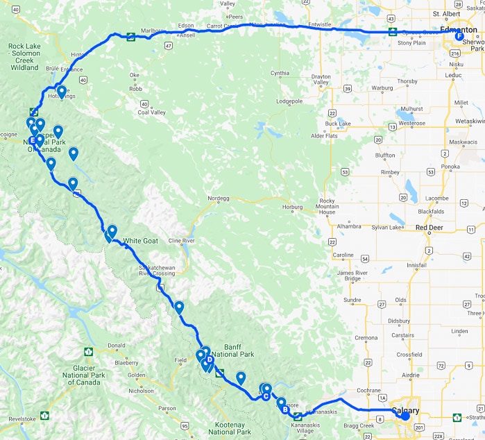
Day 1: Drive Calgary to Banff National Park
Start your Alberta Rocky Mountains road trip by driving west from Calgary on Highway 1 (Trans Canada Highway) towards Banff National Park. Make a stop in the small town of Canmore, shortly before the national park boundary, to experience beautiful scenery without the big crowds.
Approximate drive times: Calgary to Canmore- 1hr 10 mins, Canmore to Banff townsite- 32 mins
For a memorable and thrilling introduction to Alberta’s Rocky Mountains, we recommend doing a helicopter tour in Canmore . Nothing beats a bird’s eye view of the area’s most beautiful landscapes!
Our 30 minute helicopter tour flew us past the Three Sisters Peaks, Mount Assiniboine and Gloria Glacier, the Goat Range, and over Spray Valley. I was a little anxious at first, being this was my first time in a helicopter, but my nerves were quickly settled by the dramatic mountain views, something you definitely can’t experience from the ground!

Don’t rush off after your helicopter tour, as there are plenty of scenic walks and short hikes in Canmore . Our favourite is the 3.8 km Grassi Lakes Hike, which leads to two small blue-green lakes surrounded by mountains. If you choose the more challenging of the two possible routes, you’ll be rewarded with great views of Canmore, the reservoir, and a waterfall. Allow for 1.5-2 hours if you take the scenic route.

Banff Townsite
The rest of the day can be spent exploring the town of Banff. Admittedly, it’s really busy during the summer season, and too commercialized for my taste, but it’s still a beautiful place to spend the first night of your Alberta road trip.

An interesting place to visit in Banff is Cave and Basin National Historic Site. The discovery of this natural hot spring on Sulphur Mountain, and desire to protect it, led to the creation of Banff National Park. Inside the cave you can admire the sparkling turquoise waters, while outside you can see a steaming thermal water basin.

After visiting Cave and Basin, take a peek inside the historic Banff Springs Hotel, a luxurious property built in the late 19 th century by the Canadian Pacific Railway. If you wish, have dinner at the “Castle in the Rockies” before taking a short walk to Bow Falls. End your day with an evening soak at Banff Upper Hot Springs.

Some other things you could do in the town of Banff are ride the gondola up Sulphur Mountain, go hiking on Tunnel Mountain, stroll along the Bow River, and visit the scenic viewpoint at Surprise Corner.

Check prices, availability, and reviews for the Fairmont Banff Springs.
Day 2: Drive Banff to Lake Louise
Start Day 2 of your Canadian Rockies road trip by driving along the scenic Bow Valley Parkway to Johnston Canyon. Spend a few hours hiking at Johnston Canyon before continuing on the Bow Valley Parkway to the hamlet of Lake Louise, your home for the next three nights.
Approximate drive times: Banff to Johnston Canyon- 27 mins, Johnston Canyon to Lake Louise- 26 mins
Johnston Canyon
The hiking trail at Johnston Canyon is one of the busiest in Banff National Park (so get an early start), but the scenery is lovely enough that the crowds don’t detract too much from the experience.

Canyon-clinging catwalks will lead you through the gorge to two waterfalls- the Lower Falls at 1.1 km, then the Upper Falls at 2.7 km. Most people end their hike at the Upper Falls, but we recommend carrying on another 3 kilometers to the Ink Pots . Here you can enjoy seven greenish-blue pools of spring water surrounded by open meadows. It’s a fantastic place for a quiet picnic.
If you want to hike to the Ink Pots and back, plan to spend 4-5 hours. If you only want to visit the Lower and Upper Falls, allow 2- 2.5 hours for the return trip.
- Lake Louise
With postcard-worthy views and plenty of opportunities for outdoor adventure, it’s easy to understand why tourists flock to Lake Louise.

Our favourite way to escape the crowds that hang out along the shoreline is to rent a canoe and paddle across the glacier-fed lake. The turquoise water and backdrop of rocky mountain peaks are relaxing and invigorating at the same time. If you’re up to it, paddle close to Victoria Glacier which hangs at the far end of Lake Louise.

After canoeing on Lake Louise, grab a table at one of the restaurants inside Chateau Lake Louise. Our go-to meal is Swiss Fondue at the Walliser Stube. Mmm… cheesy goodness!
Check prices, availability, and reviews for the Fairmont Chateau Lake Louise .
Day 3: Plain of Six Glaciers (Lake Louise)
No driving today, instead you’ll be transported by horseback to the Plain of Six Glaciers Tea House. If horses aren’t your thing, you can also hike to the tea house.
As an alternative to visiting the Plain of Six Glaciers, you could do the shorter hike to the popular Lake Agnes Tea House.
Horseback Ride to the Plain of Six Glaciers
Travelling by horseback to the Plain of Six Glaciers is a Canadian Signature Experience and a truly unique way to explore Lake Louise.
During the 4 hour trail ride to the Plain of Six Glaciers Tea House , you’ll trot through the forest, along the shore of Lake Louise, across a field of moraine (rock deposits left behind by glaciers), then up towards the base of Victoria Glacier before arriving at the historic tea house at 7,000 ft.

If you’re like me, your legs will be stiff after such a long horseback ride so the rest of the day can be spent relaxing at Lake Louise, or perhaps checking out the view from the top of the Lake Louise Gondola (if you don’t mind the hefty price tag).
An interesting place to have dinner tonight is at The Station Restaurant, located inside Lake Louise Station . Train enthusiasts will appreciate the building’s railway heritage and foodies will enjoy the delicious Canadian cuisine.
Day 4: Moraine Lake & Larch Valley
Early in the morning, drive the short distance from Lake Louise to Moraine Lake, a must-see place on a road trip in Alberta thanks to its classic views. After admiring the famous lake, set out to hike the Larch Valley trail, which starts nearby at the Moraine Lake Lodge. Spend one final night in Lake Louise.
Approximate drive times: Lake Louise to Moraine Lake- 20 mins
Moraine Lake
You’ve probably seen countless pictures of Moraine Lake on Instagram, but long before that, this exquisite landscape lake graced the back of Canada’s $20 bills.
Moraine Lake is a perfect stop during a summer road trip in the Canadian Rocky Mountains because the water is at its bluest in June and July. The view from Rockpile Trail is stunning, with the rugged Valley of the Ten Peaks framing the vivid lake.

If you get the chance, I also recommend renting a canoe to explore Moraine Lake. It’s such a wonderful experience to paddle at the base of these beautiful mountains!
Moraine Lake is a very popular place to visit in the Alberta Rockies, so try to avoid the rush with an early morning (or evening) visit.
Hiking Larch Valley
Larch Valley is most beautiful in early autumn when the larch tree needles turn golden yellow, but even without the fall colours it’s still an enjoyable hike.
The Larch Valley hike climbs and winds up through the forest before arriving at an open meadow and valley of larch trees. Continue a bit higher to Minnestimma Lakes, or higher yet to Sentinel Pass, and you’ll be rewarded with wonderful views of the Valley of Ten Peaks.

It’s 4.3 km one way to Larch Valley/Minnestimma Lakes and the round trip can take up to 4 hours.
Day 5: Drive the Icefields Parkway to Jasper National Park
It’s time to leave behind Banff National Park and head towards Jasper via the Icefields Parkway (Highway 93), one of Canada’s most scenic drives. Spend the next three nights in Jasper.
Approximate drive times: Lake Louise to Jasper townsite- 3 hrs (without stops)
Icefields Parkway
You can’t do a proper Canadian Rocky Mountains road trip without driving the Icefields Parkway from Lake Louise to Jasper.

The road linking Alberta’s mountain parks is one of Canada’s best, as far as scenery goes. From brilliant blue lakes, cascading waterfalls, rugged canyons, imposing peaks, and icy glaciers, there’s no shortage of attractive places to pull over and revel in the views.

Since it’s a long drive with plenty of gorgeous sights, you’ll have to make some tough decisions about where to stop along the way if you want to make it to Jasper by suppertime. My favourite point of interest along the Icefields Parkway is Peyto Lake (at Bow Summit) , but I also recommend stopping at the Columbia Icefield, Sunwapta Falls, and Athabasca Falls (nearest to Jasper townsite).

Day 6: Valley of the Five Lakes, Pyramid Lake, & Lac Beauvert
Spend the day visiting some of the lakes in Jasper National Park, beginning with a hike at the Valley of the Five Lakes. From there, make the short drive to Pyramid Island, then end your day at Lac Beauvert and the Jasper Park Lodge.
As an alternative to the Valley of Five Lakes hike, you can visit Mt. Edith Cavell and do the longer Cavell Meadows hike or shorter Path of the Glacier Trail. These connected routes offer beautiful views of a glacial pond.
Valley of the Five Lakes Hike
The Valley of the Five Lakes hike is my favourite hike in Jasper because the trail makes a loop around five blue-green lakes, each with a unique shade.

There’s a short loop and long loop, both of moderate difficulty. We chose the short route and it took us just under 2 hours to complete, including plenty of time spent enjoying the scenery!
Pyramid Lake
Pyramid Lake is a great place to go for a short walk that’s not very far from town (8 km). From the tiny Pyramid Island (and shores of Patricia Lake), you get beautiful views of Pyramid Mountain reflecting in the water. It’s a lovely spot that I try to visit every time I make a trip to Jasper National Park.

Beauvert Lake
At Lac Beauvert there’s an easy 4 km walking trail that wraps around the entire lake, offering pleasing views of the surrounding mountains and shore-side Jasper Park Lodge.

If you’re tempted to get out on the water, you can rent a canoe, kayak, paddle boat, or paddle board from the boathouse. There’s a beautiful golf course here too.
Afterwards, pop inside the Jasper Park Lodge for an appetizer or dinner and continue to enjoy Jasper’s beaut iful scenery from your table.
Check prices, availability, and reviews for the Fairmont Jasper Park Lodge .
Day 7: Maligne Valley/Maligne Lake Road
For your last full day in Jasper, explore the natural sites along Maligne Lake Road, which is also a great place to spot wildlife in Jasper National Park . We’ve seen black bears and cubs, mule deer, moose, even a grizzly all on this road.
Maligne Canyon
Maligne Canyon is the gateway to Maligne Valley and the deepest canyon in the Canadian Rockies, dropping to 50 metres in places.
The six bridges crossing the canyon make it easy to experience various vantage points of this incredible landmark. You can see waterfalls, eroded limestone, and the swirling water of Maligne River. You can easily spend 2-3 hours walking along the rim of the canyon, learning from the interpretive displays along the way.

For a completely different experience, make a winter trip to Jasper when you can do the Maligne Canyon Ice Walk and see the gorge draped in ice.
Medicine Lake
Medicine Lake is worth stopping at to capture a few pictures, but what makes it really unique is something you can’t see at all.
Known as the “disappearing lake”, Medicine Lake is an area the Maligne River fills faster than it can drain. The water slowly infiltrates the ground, moving through an underground cavern system before re-emerging at Maligne Canyon.

Medicine Lake can be a good place to spot wildlife (we’ve seen a black bear with cubs here) and in the winter it’s a fun place to go snowshoeing in Jasper .
Maligne Lake
At the end of the road is Maligne Lake, the largest lake in Jasper National Park (and second largest glacier-fed lake in the world) at 22.5 km long and 1.5 km wide.

There’s plenty to do here including day hikes, canoeing, and lunching at the historic Maligne Lake Chalet. You can even take a boat tour to the famous, and highly photographed, Spirit Island. The scenery during the Maligne Lake cruise is remarkable, especially once you arrive at Spirit Island, so it’s definitely a must-do on a road trip in Alberta’s Rocky Mountains.

Day 8: Drive to Edmonton or Back to Calgary
Approximate drive times: Jasper to Edmonton- 3 hr 54 min, Jasper to Calgary- 4 hr 57 min
Now that your week-long road trip in the Canadian Rocky Mountains has come to an end, it’s time to return home. You can either drive back to Calgary, making a second trip on the Icefields Parkway and Highway 1, or take Highway 16 and fly out of Edmonton.
If you choose the Edmonton route, it’s nice to make a stop at Miette Hot Springs, the hottest springs in the Canadian Rockies, to soak up a few more moments in Alberta’s mountains. Miette Hot Springs is 61 km east of Jasper townsite, at the end of Miette Road, not far from the entrance to Jasper National Park.

Final Thoughts About Our Canadian Rockies Road Trip in Alberta
I’ve done this road trip in Alberta’s Rocky Mountains many times (I’m lucky enough to live in Alberta), but it never gets old.
There are so many great places to see and things to do in the Canadian Rockies that a road trip through the area can be different every time. Writing this post made me want to get out and drive from Banff to Jasper all over again to discover some new lakes and hikes in Alberta’s Rocky Mountains!

Tips For Doing a Road Trip in Alberta’s Rocky Mountains
Park Pass: You will need to buy a park pass at either the entrance to Banff National Park or Jasper National Park. The cost is determined by how many days you will be in the parks and how many people are in the vehicle. Annual passes are also available.
Icefields Parkway: The Icefields Parkway has very few services, so be sure to pack snacks and a lunch (there are plenty of great picnic spots). Also, make sure to fill up with gas in Lake Louise or Jasper as there’s only one gas station at the Saskatchewan River Crossing Resort and prices are usually higher here.
- There is no cell reception along the Icefields Parkway and service in Banff and Jasper National Parks can be spotty. Don’t expect cell service in the wilderness areas.
- Most viewpoints and pullout areas have outhouses if you need a bathroom break.
Wildlife : Be alert for wildlife on roads and hiking trails. Educate yourself on what to do if you encounter wildlife and always keep a safe distance. Make sure you bring bear spray if you will be doing hikes on your Canadian Rockies road trip.
Winter: If doing this road trip in the winter, be prepared for icy conditions and extreme weather (especially on the Icefields Parkway). Pack extra clothing, food, and check the road reports before heading out. Sometimes parts of the Icefields Parkway get closed if conditions are bad or there’s a high risk of avalanches.
- For ideas of things to do in Alberta in the winter, visit our Romantic Winter Getaways in Alberta post.
Accommodations and Camping: Accommodations and campsites can fill up in the summer season, so make sure to book them well in advance. Pickings are especially slim in Lake Louise.
- To find and book a campsite, visit the Parks Canada Reservation Service. Reservations for the summer season usually open in late January.
Extend Your Trip: If you want to extend your trip to the Canadian Rockies, we suggest adding a few more days in Jasper National Park. Not only is it beautiful with a laid-back vibe, there are so many fun adventures and things to do in Jasper National Park that it’s sure to be a highlight of your Alberta vacation.
Information was correct at the time of publishing, but can change without notice. Please confirm directly with service providers.

Accommodations in the Canadian Rocky Mountains
For your convenience, here is a list of hotels for the stops on this Alberta road trip itinerary. Please consider booking your accommodations through the included link. It costs nothing extra and helps support this website. Thank you!

More Canadian Rockies Destinations and Travel Guides
- THINGS TO DO IN WATERTON LAKES NATIONAL PARK- OUR 7 DAY WATERTON ITINERARY
- Stargazing at the Jasper Dark Sky Festival
- 8 Reasons to Visit Jasper in January (and all Winter Long)
- Winter in Jasper National Park- A Frosty Photo Series
- Romantic Trip to Lake Louise- Our Favourite Activities for Romance
Follow Us On Social Media
Facebook | Instagram | X | Pinterest
Join the Facebook Group
JavaScript seems to be disabled in your browser. For the best experience on our site, be sure to turn on Javascript in your browser.
Recently added item(s) ×
You have no items in your shopping cart.
- Travel Videos
- Travel Maps
- Language Courses
- Inflatable Globes
Alberta Road Maps | Detailed Travel Tourist Driving
Alberta - visit the impressive entrepreneurial province.
People from all over the world choose to live and work in Alberta because of the diverse communities, high standard of living and beautiful landscapes along with sustainability, economic growth, and job creation all makes it the Entrepreneurial province of Canada.
Alberta is the western province of Canada and is the fourth-most populous. It’s 661,848-square kilometer is enclosed by Saskatchewan in the east, by the Northwest Territories in the north, by British Columbia in the west, and by Montana in the south.
The landscape of Alberta comprises not only of mountains, prairies, deserts, coniferous forest, but also gently sloping wheat fields, vast granaries, expansive cattle ranches, and huge oil refineries.Agriculture is Alberta's economic backbone.
The largest city is Calgary and Edmonton, the capital city is the second largest.Other prominent cities are Fort McMurray, Lethbridge, Medicine Hat, Red Deer, and St. Albert.
It has attractions like skiing, hiking, and camping, shopping spots like the West Edmonton Mall, Calgary Stampede the rodeo exhibition and festival as well as athletic and sporting competitions. The Elk Island National Park, Wood Buffalo National Park, and the Columbia Icefield are natural attractions.
Banff has been identified as one of the Best World Destinations for 2017 by National Geographic Traveler magazine.The Banff National Park is well-known for wildlife, its Canadian Rocky Mountain beauty, and entertainment prospects with more than four million travelers every year.
The 10,000-square km Jasper National Park is the largest wilderness park in the Canadian Rockies and is the largest easily accessible Dark Sky Preserve in the world and it is a four-hour drive from Edmonton.Visit Alberta with a map and enjoy everything the Park offers like the ‘star gazing’ experience, Sidewalk Astronomy Roves in the daytime all through summer, and interpretations in the fall like Mysteries of the Night to enhance visitors.
Alberta Road and Physical Travel Reference Map.
Item Code : ITMB4650

Southern BC and Alberta, Road and Physical Travel Reference Map, British Columbia and Alberta, Canada.
Item Code : ITMB17845

Jasper National Park and Northern Alberta, Road and Physical Travel Reference Map, British Columbia and Alberta, Canada.
Item Code : ITMB4233

Calgary and Alberta South, Road and Physical Travel Reference Map, Alberta, Canada.
Item Code : ITMB4232

Alberta WALL Map, Canada.
Item Code : ITMB4229

Southern Alberta Reginal Map, Canada.
Item Code : GMJO7781

Edmonton, St. Albert, Sherwood Park and Red Deer City Street Map, Alberta, Canada
Item Code : GMJO7741

Alberta Road and Tourist map, Canada.
Item Code : GMJO7877

Alberta Recreation Road and Tourist Map, Canada.
Item Code : MART4648

Alberta Province Road and Tourist Map, Canada.
Item Code : MART4645

Alberta Southwest and BC Southeast Road and Topographic Tourist Map, British Columbia and Alberta, Canada.
Item Code : GEMT4649

Alberta Pocket Tourist Road ATLAS, Canada.
Item Code : MART4653

Alberta Northern, Road and Recreation ATLAS, Canada.
Item Code : MSIO4654

Alberta Central Map Book, Road and Recreation ATLAS, Canada.
Item Code : MSIO4655

Alberta Southern, Road and Recreation ATLAS, Canada.
Item Code : MSIO4656

Alberta, Southwestern Map Book, Road and Recreation ATLAS, Canada.
Item Code : MSIO4657

Alberta Cities Street ATLAS, Canada.
Item Code : MART21358
Banff National Park (Map and Guide), Road and Topographic Tourist Map, British Columbia and Alberta, Canada.
Item Code : GEMT4660

Banff & Jasper National Park, Road and Physical Travel Reference Map, British Columbia and Alberta, Canada.
Item Code : ITMB4663

Scale 1:240,000/1:250,000. Size 27"x39". 4th Edition. International Travel Maps edition. The great national parks of Banff and Jasper have long been enormous travel destinations within North America. The Canadian Rockies are more majestic than those of their southern cousins, and townsites like Lake Louise, Banff, and Jasper resonate with visitors in a way that more established townsites don't seem to do.
This is a double-sided map, with a double-sided cover, so can be displayed either with the Banff side facing outwards or the Jasper side. Either way, this is marvelous map, offering both national parks for one price in excellent detail, showing camping spots, hiking trails, scenic attractions, and areas of accommodation. The map includes an excellent inset map of Banff, the only real town inside the parks, and more basic ones of Lake Louise and Jasper. Try swimming at the sulphuric-laced hot springs pool high above Banff!
Banff National Park, Road and Topographic Tourist Map, British Columbia and Alberta, Canada.
Item Code : GEMT4659

Items 1 - 20 of 55
- You're currently reading page 1
- Remove This Item
- Add to Cart Add to Cart Remove This Item
You are using an outdated browser. Please upgrade your browser to improve your experience and security.
Multimedia Library
Photography, videos and brand assets for marketing Alberta.

Travel Alberta’s multimedia library shares brand resources including photography, video footage, maps and stories. You can use this library to find the visual and content support to promote Alberta’s authentic experiences in breathtaking landscapes.
Access the multimedia library
Register for Access
On registration, you'll be granted limited access to the library while your account is reviewed. Once your account is reviewed, you'll be able to see a larger selection of assets.
Usage Guidelines
The Multimedia Library is intended to support creative that promotes Alberta as a tourism destination. Access to library must align with our Terms and Conditions of Use.
Brand Story
Use these attributes and assets for effective and cohesive brand storytelling, content development, and campaigns.
Tips and tricks
- Utilize the search options available to find the right assets for your project, such as refining by region, season, and folders that sort images according to landscapes, cityscapes, experiences, and so on.
- If you’re not sure where to start, browse the categories on the home page, which have a selection of images divided into summer and winter categories.
- If you are interested in aligning the assets you choose with Travel Alberta’s current brand guidelines, these guidelines can be found under the “Brand” tab in the Multimedia Library.
- To find the latest summer and winter assets, use the SUMMER REFRESH and WINTER WARMTH tabs in the top menu bar.
- Pay attention to file names. Each file has a letter and two numbers at the start of its file name. The number refers to the year the image was added to the library. For example, a file labelled with “a21” means the image was added in 2021. Sort by Creation Date in descending order to see the newest files at the top of your search results.
- Create a collection to download multiple images at once. You’ll be able to revisit this collection in the future, too.
- If you’d like to keep selected images but need to end your Multimedia Library session, save them as a collection so you don’t have to start your search again.
- Review the Terms & Conditions if you’re unfamiliar to ensure the assets you choose are suitable for your project.

How do I search for assets in the Multimedia Library?
Use the search bar along the top of the screen to make general inquiries. For example, you could type in “Calgary” or “Skiing”, which would return hundreds of results. To refine your search, navigate to the options on the left side of the screen and choose specific locations, such as “Banff National Park” for the skiing example. You can narrow your search further by choosing the file extension (this can help filter out videos if you only need photos), folder (experiences, landscapes, cityscapes, and so on), media type, orientation (horizontal, vertical, or panoramic), region, and season.
Where can I find the newest assets?
You’ll see a row of tabs along the top of the Multimedia Library home screen. Click on SUMMER REFRESH and WINTER to learn more about the latest seasonal campaigns and how to align your selected imagery with Travel Alberta’s brand guidelines.
How do I download an individual file?
There are two ways to do this. The first is by clicking the downward arrow icon that appears when you hover over an image thumbnail.
What do the image tiers mean?
When you view a photo in the Multimedia Library, you’ll see a tier rating on the right-hand side with the other image information. The tiers are broken down as follows:
- Tier 1, Goosebump Moments: These awareness images are reserved for TA-led creative only. These photos are intended to be used in primary applications like campaign ads, tradeshow banners, and main website pages.
- Tier 2, Brand Experiences: This photography is more marketing/product-driven. The images focus on the moment of interaction between two or more people engaged in an experience. These photos are for general use and can be shared.
- Tier 3, Editorial: These images give additional context to a story. They may portray architecture, landscapes, wildlife, or close ups of people or products. These are used alongside tier 1 or 2 images and displayed at a smaller size.
Which file size should I download?
When you choose to download an image (or images) you’ll be asked to select a size – Convert to PNG, Low-Res JPG, Medium-Res JPG, High-Res JPG, or TestPreset. You can also opt to download the original file, which will be quite large.
- Low-Res JPG: Best for projects that will be viewed on-screen, such as PowerPoint presentations.
- Medium-Res JPG: These images can also work well on-screen, however they will increase the overall size of your project. They can also be used for small-scale printing or when small images are required in a piece.
- High-Res JPG: Best for larger print products, such as brochures, reports, and banners
What are collections and how do I create one?
Collections allow you to save a group of images for a specific project and access them again later.
- To add assets to a collection, click the + icon that appears when you hover over an image, or
- Click on the asset to view it in a larger size and then choose “add to selection” from the drop-down menu.
- Create a name for your collection
- If you need to access your collection again, choose the correct name from the drop-down menu in the top-right corner of your screen.
How do I download a collection?
Navigate to your collection through the drop-down menu in the top-right corner of the screen, as mentioned above. Choose “Download” from the options in the green bar at the bottom of the next screen, and then choose the correct file size for your project.
Why do I need to fill out a form to justify my download?
There are instances in which the file you request to download may need to be approved by an administrator. The admin team will ensure this happens as quickly as possible, and they thank you for your patience.
In other instances, Travel Alberta uses these forms to keep track of file-use information for information purposes. Thank you for providing this valuable information to the organization.
How do I share an asset collection with another team member?
Choose the “Share” option from the green bar in the image above, which will provide options to create a title for the selection assets, a duration for the link, and security (password protection).
Next, you’ll be asked to choose the asset size. Choose the best option for the recipient’s needs. Then click “Create Link.” You can then either email the link or copy it to your clipboard and share in other ways.
Can't find what you're looking for? We're here to help.

Maryanne Doran
Brand & Content Specialist
Modal Heading
- © Roadtrippers
- © Mapbox
- © OpenStreetMap
- Improve this map
IMAGES
COMMENTS
Canada's Rocky Mountains hold unforgettable experiences for all who visit. Explore our mountains. Banff, Canada's first national park, was established in 1885. Banff has 1,600 km (994 mi) of maintained trails—that's like walking the length of New Zealand.
Maps. Alberta is a province in western Canada. It is located between British Columbia and Saskatchewan, and Montana is its closest US neighbour. Visit the links below to learn more about ways to travel throughout the province.
Days 3 & 4 - Banff National Park. The lakes really are this blue in Banff National Park. Banff National Park is one of Canada's top adventure and scenic destinations and will surely be a shining star on your road trip through Alberta. To get to Banff National Park, hop in your car and drive one hour west from Calgary.
Start your adventure in Calgary and travel back to prehistoric times to the Dinosaur Capital of the World: Drumheller, Alberta. Explore all the Alberta Badlands have to offer during this two or three day road trip. Immerse yourself in a culturally-infused journey punctuated with remarkable landscapes, historic sites and natural wonders.
Welcome to the enchanting province of Alberta, a captivating destination nestled in the heart of Canada. Known for its breathtaking natural beauty, Alberta offers a diverse range of landscapes that will leave travelers in awe. From the majestic Canadian Rockies to the vast prairies and vibrant cities, Alberta is a haven for nature enthusiasts ...
About, 6,566.6 sq. km of total land area in Alberta is occupied by Indian reserves. With an area of 661,848 sq. km, Alberta is the 6 th largest and the 4 th most populous Canadian province. Located in the heart of the Edmonton Capital Region and on the North Saskatchewan River, is Edmonton - the capital and the 2 nd largest city of Alberta.
The Rocky Mountain Parks. The most iconic tourist destination in Alberta — and possibly the entire country — is the beautiful Banff National Park and its emerald-green Lake Louise.Containing over 6,000 square kilometers of unspoiled Rocky Mountain scenery, Canada's most popular outdoor resort is home to virtually every activity you could imagine, with over 1,000 km of hiking trails, a ...
Travel paths forged in HBO's The Last of Us. Explore the incredible sights and eerie locations of HBO's Alberta-filmed series, The Last of Us, for yourself. The first season was filled with iconic shots from across the province, including downtown Calgary, the Legislature Building in Edmonton, Fort Macleod, Canmore and Calgary's SAIT and ...
13 Days. Embark on an epic tour to learn more about Alberta's rich Indigenous history and culture. Explore natural wonders, historic sites and educational centres - one urban hub at a time. Explore cities and mountains on this 8-day scenic road trip that starts in Edmonton, takes you through the beautiful Rocky Mountains and finishes with ...
Alberta tourist map Click to see large. Description: This map shows cities, towns, regions, visitor information centres, unesco world heritage sites, airports, primary highways, Trans-Canada highway, crowsnest highway and U.S. ports of entry.
The province's main tourist draws are the Rocky Mountain towns of Banff, Canmore, Lake Louise and Jasper. Alberta trip planning is easy when you begin your RV adventure in Calgary. Our Calgary location is an ideal place from which start your exploration of Alberta. We're located close to Calgary International Airport and we are happy to ...
The detailed Alberta map on this page shows the province's major roads, railroads, and population centers, including the Alberta capital city of Edmonton, as well as lakes, rivers, and national parks. To zoom in on the detailed Alberta map, click or touch the plus ( +) button; to zoom out, click or touch the minus ( -) button.
Alberta, Canada is a province that boasts stunning natural beauty, rich history, and a vibrant culture. From the majestic Rocky Mountains to the rolling prairies, Alberta offers a diverse range of landscapes and experiences for visitors to explore. Whether you're interested in outdoor adventures, cultural attractions, or historical landmarks ...
A curated list of where to eat and drink. Plus, details on festivals, guided tours, and more. Information on road conditions and driving tips, national park passes, and wildlife safety. Direct links to booking pages, to enable easy planning. A custom Google map you can launch on your phone to lead you around the area.
Roads were made for journeys, not destinations. Alberta is a big province for road-tripping. Road Trip Alberta will provide you with details on popular routes, destinations, and everything in between. Expect detailed destination guides, reviews, itinerary ideas, and more!
Find local businesses, view maps and get driving directions in Google Maps.
SaveEditCancel. Provides up to the minute traffic and transit information for Alberta. View the real time traffic map with travel times, traffic accident details, traffic cameras and other road conditions. Plan your trip and get the fastest route taking into account current traffic conditions.
Day 4: Moraine Lake & Larch Valley. Early in the morning, drive the short distance from Lake Louise to Moraine Lake, a must-see place on a road trip in Alberta thanks to its classic views. After admiring the famous lake, set out to hike the Larch Valley trail, which starts nearby at the Moraine Lake Lodge.
In the spirit of respect, reciprocity and truth, Travel Alberta honours and acknowledges the traditional territories of the many First Nations, Métis and Inuit in Alberta. Alberta is situated within historical and present-day lands that Indigenous Peoples have cared for and lived on for generations. We honour the territories of Treaty 4, 6, 7 ...
Southern BC and Alberta, Road and Physical Travel Reference Map, British Columbia and Alberta, Canada. $17.95. Item Code : ITMB17845. Scale 1:1,000,000. International Travel Maps edition. ITMB, being based in Vancouver, BC, understandably has a local/regional market for our map line. We have a map of Western Canada, as well as an atlas, a very ...
Travel Alberta's multimedia library shares brand resources including photography, video footage, maps and stories. You can use this library to find the visual and content support to promote Alberta's authentic experiences in breathtaking landscapes. Access the multimedia library.
The ultimate road trip planner to help you discover extraordinary places, book hotels, and share itineraries all from the map.