
- Protective Actions

- ColorVision Assist Adjusts AQI colors to enhance contrast to assist individuals with color vision deficiencies.


Fire and Smoke Map
Showing air quality conditions from FINE PARTICULATE MATTER (PM2.5) generated by various sources including wildfire smoke
Ozone can be found here: AirNow
Initializing the Map...
Enable geolocation to view conditions near your location
Search Location
Return to geolocation sorry, your browser does not support inline svg..
Search for Current Fire and Smoke Conditions in a city, state or area. (e.g. "Seattle, WA", "Washington State", "Smith River, CA")
Or search for conditions near your current location
Fire and Smoke Map v3.1
Fire and Smoke Map: The EPA and USFS have created this map to test new data layers of use during fire and smoke events, including air quality data from low-cost sensors. While these sensors don’t meet the rigorous standards required for regulatory monitors, they can help you get a picture of air quality nearest you especially when wildfire smoke is in your area. The EPA and USFS will update the map layers several times during year, as we respond to feedback and work to improve the map.
Please note:
- The data on the AirNow Fire and Smoke Map are intended to help individuals make decisions to protect their health during fires.
- If there is a wildfire in your area, please stay tuned to local authorities for the latest information on fire and smoke safety.
- EPA will not use the data on this map to make regulatory decisions.
- Mention of trade names or commercial products does not constitute EPA or USFS endorsement or recommendation for use.
- New in 2022: Enhanced information display including recommended actions and PM2.5 trends.
See the User's Guide to learn more about Using the Map
Service Alert
No Current Service Alerts
Bookmarking this Page
Click this link to copy your current URL settings to the clipboard. You can then insert the URL into the bookmarks manager to maintain your current settings (saved locations, ColorVision Assit preferences).
AirNow Fire and Smoke Map
About the airnow fire and smoke map.
The AirNow Fire and Smoke Map provides information that you can use to help protect your health from wildfire smoke. Use this map to see:
- Current particle pollution air quality information for your location;
- Fire locations and smoke plumes;
- Smoke Forecast Outlooks, where available; and,
- Recommendations for actions to take to protect yourself from smoke. These recommendations were developed by EPA scientists who are experts in air quality and health.
New in Version 3
Version 3 of the map includes a number of enhancements:
- Spanish Version (introduced October 2022) Click the globe symbol in the upper right and select Español to change the display language to Spanish.
- ColorVision Assist (introduced in May 2022) This feature makes the map more accessible for people with color vision deficiencies. To see a version of the map with a modified Air Quality Index (AQI) color scale, click the color wheel in the upper right-hand corner. The modified scale enhances contrast between the colors, which makes it easier to distinguish the AQI categories.
- Ability to save monitors and sensors to a “favorites” list Do you frequently check the same monitor or sensors? Now you can save them to a favorites list. See the “How To” tab to learn how.
- Improved sensor data correction equation The EPA has updated its scientific correction equation to provide more accurate sensor data.
- Fire perimeters on the map When you click on a large fire incident icon (icon), now the fire perimeter will show on the map, (where perimeter data is available).
Acknowledgments:
This map is a collaborative effort between the U.S. Environmental Protection Agency (EPA), led by Ron Evans, and the U.S. Forest Service (USFS) led Interagency Wildland Fire Air Quality Response Program, led by Pete Lahm, USFS. Development work led by Sim Larkin, USFS, and Stuart Illson, University of Washington, in collaboration with the EPA AirNow Team. Correction equation work was led by Karoline Barkjohn, EPA. Additional thanks to Jonathan Callahan, Desert Research Institute, Marlin Martínez, University of Washington, and many others. This site relies on data provided from a number of sources, including AirNow, the Western Regional Climate Center, AirSis, and PurpleAir for monitoring and sensor data, and the NOAA Hazard Mapping System and National Interagency Fire Center for fire and smoke plume information. Feedback and questions can be directed to [email protected] .
Note: Mention of trade names or commercial products does not constitute EPA or USFS endorsement or recommendation for use.
How to Use the Map
The icons on the map are clickable. Click a:
- Permanent Air quality Monitor
- Fire icon for information about the fire.

Setting a Location
Entering a location makes more information available to you. If you didn’t enter a location when you first opened the map, or want to change your location, click the icon on the upper right-hand corner of the screen. That will open a box where you can type in a location of interest. Selecting the blue dot icon: will return you to your set location. You can also drag the blue dot icon to a location of interest.
Making a favorites list
You can save locations by creating a favorites list. Here’s how:
- Click on a monitor or sensor, then click the “Add to Favorites” button on the lower left corner of the popup box. Do this for each monitor or sensor you want to add.
- After you’ve added the monitors or sensors you want to save, click the location icon (icon) on the left side of the page. You will see your saved locations.
- Click the “Bookmark” link. That generates a unique web address (URL) and opens a pop-up box where you can copy the URL to the clipboard.
- Open a new tab in your browser. Paste the URL you copied to the clipboard into the address bar, then bookmark it. Go to the bookmark each time you want to check the Map. You also can share the unique URL with others.
Need more help? See our User Guide available here
About the Data
The Fire and Smoke Map shows information on particle pollution, fires and smoke plumes:
- Particle pollution, also called fine particulate matter or PM 2.5 , is the main type of pollution in smoke.

- The Map does not show other types of air pollution, like ozone, that also may affect your air quality. Visit AirNow.gov to see ozone information near you, or check your state or local air agency website.
- Note: Sensors sometimes report over- or underestimates of the actual amount of particle pollution in the air. Before sensor data appears on the Map, we apply an EPA scientific correction equation so you can compare sensor data to data from permanent monitors. Learn more about our data processing steps here .

- Note: Satellites find fires by sensing temperatures on the ground and then looking for areas with the same temperature as a fire. False detections can occur in places with high ground temperatures or sun reflection. Satellites also routinely find multiple hotspots for a single large fire.
- Smoke plumes shown on the Map indicate that smoke is present. However, the smoke may be high in the air instead of at ground level.
- Note: The monitor or sensor icons on the Map always show air quality near ground level. Click a monitor or sensor icon to see how smoke is affecting the air you breathe.
Disclaimers:
- EPA does not use the data on this Map to make regulatory decisions.
- Always stay tuned to local authorities for the latest information on wildfires, smoke , and safety.
Learn more about the work that goes into bringing you the information on the Map. See our Frequently Asked Questions available here
Actions to Take
The AQI has six categories, ranging from Good to Hazardous. The table below shows the actions you can consider taking for each category.
AQI Categories and Recommended Actions
Pay attention in extreme heat..
Extreme heat can lead to potentially deadly illnesses, such as heat exhaustion and heat stroke. If it is hot outdoors, and you feel hot indoors, go somewhere with air conditioning, if possible.
Want to learn more?
Find additional links and FAQs available here to learn more about wildfire smoke and your health.
Use the above tabs to learn How to Use this Map, about Data that is shown on the map, and about Protective Actions you can take.
Want to know more about the Map and wildfire smoke and your health?
Visit https://www.airnow.gov/fasm-info to read:
- Frequently Asked Questions
USFS and EPA continue to pilot improvements to the Fire and Smoke Map. We welcome your feedback.
Have a suggestion? Please email us at [email protected]
For more information about the Fire & Smoke Map please contact [email protected]
Local conditions can change rapidly. Pay attention and take action especially if you don’t feel well.
Unsupported Browser
If you are seeing this message, it is because you are not using a modern web-browser. This site utilizes modern web-technologies to generate the Fire & Smoke Map and give location specific information to the user. Please either update your web-browser, or switch to a more modern solution. An example of a modern web browser is:
- Edge (>= version 81)
In the event you are unable to update your browser, here are some additonal sites that can provide air quality, fire and smoke information.
- PM 2.5 Air Quality Map
Geolocate | Search
Click to GeoLocate
Bookmark | Remove All | Show Banner
Viewing Conditions Near:
No Monitor Nearby
Air Quality (PM 2.5 )
Fire information, smoke plumes, smoke outlooks.

Maui Travel Updates
Maui Recovery

On August 8, 2023, wildfires resulted in the devastating loss of loved ones, homes, cultural and historical sites, and businesses in Lahaina, located in West Maui. We extend our deepest condolences and heartfelt aloha to all those who have been affected by this tragedy. We also urge visitors throughout Hawai‘i to be especially mindful and respectful in our island home as our community continues through this extremely difficult time. The Hawaiʻi Tourism Authority is continuously coordinating efforts with federal, state and county emergency management officials, as well as our community partners, visitor industry and Global Marketing Team. We are also providing updates to our travel partners — airlines, accommodations, ground transportation companies, activity providers, travel agents, and wholesalers, as well as to local, national and international media — to ensure the public is kept informed.
While Lahaina itself will remain fully closed to the public until further notice out of respect to the town’s residents, West Maui accommodations have reopened to visitors.

Latest News
February 15, 2024
Mākaukau Maui - We Are Ready
With a deep commitment to our community’s well-being, West Maui is ready to return a comforting sense of stability to the lives of its residents. Reopening our doors is one step towards reducing the uncertainties that weigh on our shoulders. It also ensures our community has the jobs and financial opportunities to thrive. On the horizon is a new day. As one, Maui is moving forward – hopeful and optimistic that it can share its culture with those beyond our shores. Learn more at: https://makaukaumaui.com .
Hawai‘i Tourism Authority Board Approves Action Plan to Support Maui’s Recovery in 2024
On December 22, 2023, the Hawaiʻi Tourism Authority Board of Directors furthered its ongoing commitment to mālama Maui and support the island’s recovery by approving an immediate six-month action plan for 2024 to help address major challenges confronting residents, small businesses, visitor industry providers, Maui’s economy, and families seeking housing. Learn more here . The action plan is designed to fulfill tourism’s responsibilities in alliance with the leadership established by Governor Josh Green, M.D. and within the broader scope of Maui’s recovery efforts being conducted by the State Department of Business, Economic Development and Tourism (DBEDT) and other state agencies. HTA’s full report identifying major strategies and not only short-term but also mid- and long-term recommendations is being provided to DBEDT in their role coordinating the State’s Economic Recovery Support Functions. Read the full report .
Hawai‘i Tourism Authority Board Of Directors Approves $2.6 Million In Funding For Maui Marketing Recovery Plan
HTA's Board of Directors took decisive action at its monthly board meeting on August 31 to approve $2.6 million in funding to launch the Maui Marketing Recovery Plan , which is centered around a new Mālama Maui campaign with heartfelt messages shared by kama‘āina of Maui. The plan's focus is to rebuild responsible travel demand from the United States market to Maui in the wake of the devastating Lahaina wildfires. Watch the board meeting . HTA staff and board members were on Maui throughout August to meet with residents and business owners and listen to them about the challenges they now face with visitor arrivals decreasing significantly since August 8. Visitors help to support the economy, supporting local shops, local restaurants, and local activities which ultimately aids in the island’s overall recovery efforts.

For Visitors

For Businesses

For Employees

For Community
Travel trade.
Information and resources for travel advisors is available on our GoHawaii website.
Mālama Maui
NOTE: While multiple dictionary sources propose "Lāhainā" as the old pronunciation for the region, living kūpuna, mānaleo and recordings of mānaleo serve to demonstrate that the contemporary pronunciation is Lahaina. Heeding the call from the Lahaina community, HTA uses the spelling Lahaina across all platforms.

What to Know About Maui’s Wildfire Recovery Efforts and How Travelers Can Help
West maui hotels and resorts are not taking future bookings at this time as officials focus on search and recovery efforts in what is now the deadliest u.s. wildfire in more than 100 years. here’s how travelers can help those affected..
- Copy Link copied

“The town of Lāhainā has been destroyed,” stated Hawai‘i Governor Josh Green, who assessed the damage over the weekend.
Courtesy of the Office of Hawai‘i Governor Josh Green
Less than a week after catastrophic wildfires blazed through several areas of the islands of Hawai‘i and Maui, the situation in western Maui—which received the brunt of the devastation—is truly heartbreaking.
“The town of Lāhainā has been destroyed,” Hawai‘i Governor Josh Green declared in his latest emergency proclamation , issued on Sunday. Lāhainā is located along the western coast of the island of Maui just south of the Ka‘anapali and Kapalua beach areas, and now that the fires have started to subside, the extreme toll of the infernos is gradually coming into focus.
The Lāhainā fire is already the deadliest U.S. wildfire in more than a century with the death toll having climbed to 96. And officials have warned that the effort to find and identify the dead is “still in its early stages,” the Associated Press reported .
“The fires have caused significant loss of life and property in Maui County. Thousands of people are without adequate shelter,” Governor Green stated. The state has launched a Hawaiʻi Fire Relief Housing Program aimed at connecting displaced Maui residents with available rooms and accommodations.
“We are going to need to house thousands of people. We are asking folks in the community to rent out those extra rooms, the ‘ohana units or accessory dwelling units (ADUs) in their homes, vacation rentals, or whatever safe and secure rooms they have available,” stated Governor Green.
Is Maui closed to tourists?
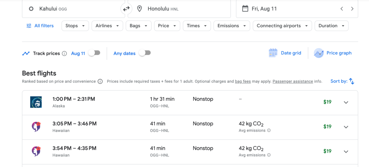
Visitors are being asked to postpone travel plans to west Maui for the coming weeks and months as recovery efforts are underway. The many travelers who were in Maui at the time of the wildfires have “largely heeded the call to leave the island,” according to the Hawai‘i Tourism Authority, which reported that around 46,000 people have flown out of Maui’s Kahului Airport (OGG) since Wednesday.
Hotels in West Maui have temporarily stopped accepting future bookings and many hotels in the area are housing employees, evacuees, and first responders in lieu of vacationers.
“While efforts are underway to restore basic services, like power and communications, visitors are encouraged to refrain from attempting to reach west Maui accommodations for reservation adjustments until the situation improves,” the Hawai‘i Tourism Authority stated.
Among the properties affected have been the Ritz-Carlton Maui, Kapalua and the Westin Maui Resort & Spa, Ka ‘ anapali , both of which have advisories on their websites stating that they remain temporarily closed. Hyatt Regency Maui Resort and Spa hotel is currently closed through September 5. And the Outrigger Hospitality Group reported on its website that its 18-room bed-and-breakfast the Plantation Inn located in the historic Lāhainā Town “has been irreparably damaged as a result of the devastating wildfires.”
Travel to the other Hawaiian Islands, like Kauaʻi, Oʻahu, Lānaʻi, and Hawaiʻi Island, are not affected at this time, according to the Hawai‘i Tourism Authority.
Maui travel update
Kahului Airport (OGG) on Maui remains open, according to Hawai‘i’s Department of Transportation , but the airport has been sheltering evacuees and thousands of travelers who have been stranded by the catastrophe, Maui County reported.
In light of the wildfires and devastation, all of the major U.S. airlines have issued travel waivers. While all major U.S. carriers dropped most of their change fees (for all but Basic Economy seats) during the pandemic, typically a fare difference will still apply, unless there is an official emergency-related waiver.
Hawaiian Airlines has a waiver in place for all flights to and from Maui’s Kahului Airport between August 9 and August 31, 2023. The state airline has added extra flights to help get travelers and evacuees out of Maui, and it is selling seats through August 20, 2023, for just $19 “to facilitate urgent travel out of Maui.”
Southwest Airlines has informed its customers that those holding reservations for travel to, from, or through Kahului through September 4 can rebook in the original class of service or travel standby within 14 days of their original date of travel between the original city-pairs with no additional charges. For flights that are canceled, customers can request a refund. Travelers can also exchange their flights that were scheduled for Kahului for flights to Hilo and Kona (on the island of Hawai‘i), Honolulu (on O’ahu), or Lihue (on Kauaʻi), for no extra charge.
Those scheduled to travel to or from the islands of Maui, O’ahu, Hawai‘i, or Kauaʻi with American Airlines will have their change fee waived until August 18 for any class of travel if they reschedule or cancel their flight.
United Airlines has a travel alert in place allowing those traveling to Kahului through September 16 to reschedule without incurring a fare difference for a new flight that departs by November 18, 2023. Tickets must be in the same cabin and between the same cities as originally booked, or in lieu of Maui, travelers can opt to fly to Honolulu, Kona, or Lihue instead. Passengers can also cancel and bank the credit or cancel and request a refund, according to the carrier.
Delta Air Lines has a fare difference waiver in place for travel to and from Maui for flights that were scheduled through August 31, 2023, as long as the new flights take place by August 31, 2023. After that, a fare difference may be applied.

Lāhainā's beloved 150-year-old banyan tree was badly scorched during the wildfires but is still standing.
How to help Maui
For travelers witnessing the tragedy from afar and wondering how they can help, several organizations have jumped in to provide aid and assistance.
American Red Cross
- To donate: https://www.redcross.org/donate/donation.html/
Red Cross teams are in Hawai‘i faciliating shelters for the displaced, which includes thousands of residents and tourists who have been evacuated to O‘ahu, and providing them with food and emotional support. “When it is safe to do so, Red Cross teams will help with damage assessment and distributing relief supplies,” the global aid organization said in a statement about its Hawai‘i wildfire relief efforts.
Council for Native Hawaiian Advancement
- To donate: https://www.memberplanet.com
This nonprofit organization that supports Native Hawaiians is raising support “for ‘ohana impacted by the devastating wildfires on Maui.”
Maui Food Bank
- To donate: mauifoodbank.org/donate
The Maui Food Bank, which distributes food to the hungry in Maui County, is raising money to help feed residents of Maui who have been displaced by the fires.
Maui Strong Fund
- To donate: https://www.hawaiicommunityfoundation.org/maui-strong
The Hawai‘i Community Foundation, a nonprofit organization that focuses its efforts on creating an equitable and vibrant Hawai‘i, has developed the Maui Strong Fund to provide shelter, food, financial assistance, and other services to residents.
Maui United Way
- To donate: https://ignite.stratuslive.com/auw/get-involved/donate/mauirelief
Community aid organization Maui United Way has created a fund a Maui Fire Disaster Relief Fund that will assist victims of the fires.
This story was originally published on August 9, 2023, and has been updated to include current information.

- ABC7 Bay Area 24/7 live stream Watch Now
- Watch ABC7 newscasts on demand Full Story
- Hawaii wildfires
Maui wildfires: Everything you need to know about navigating airline travel advisories

SAN FRANCISCO (KGO) -- The travel advisory issued for Maui in the wake of the Hawaiian island's deadly wildfires is forcing many tourists and airline passengers to scramble for alternative travel arrangements.
The advisory urged people to avoid unnecessary travel to the Maui area so that emergency officials could allow evacuees and people impacted by the wildfires to safely leave the area.
If you are one of those travelers trying to figure out what the advisory means to you, here's what you need to know:
VIDEO: Maui wildfire: Aerial video shows widespread devastation in Lahaina

What does the travel advisory say?
Issued by the state's acting Governor, it says: "Due to the ongoing wildfires on Maui caused by Hurricane Dora, Acting Governor Sylvia Luke issued an emergency proclamation to extend the state of emergency to all counties, discourage non-essential air travel to Maui, and to order all affected state agencies to assist with the evacuation."
Additionally, the advisory said: "As the wildfires continue, visitors with current and planned lodging at West Maui hotels may not have accommodations... The proclamation encourages visitors in West Maui to depart the island as soon as safe and practicable."
How are airlines responding?
Alaska Airlines
The airline posted this on social media: "We are closely monitoring the devastating impacts from the Maui wildfires, and we are continuing to operate all of our scheduled departures from Maui. A flexible travel policy is in place to allow guests to leave the island as soon as needed or postpone planned travel to the island." Alaska provided more details about its flexible travel policy when it comes to changing or cancelling flights on its website .
American Airlines
American is also waiving change fees but there are some requirements to be eligible for that. Full details are on their website .
Delta Airlines
Delta says that change fees will be waived if the new flight occurs before August 16, 2023. After that may incur a fare difference charge. But if the ticket is canceled altogether, then Delta will allow passengers to use the unused value of the ticket toward a future purchase of a new ticket. Details on their website.
RELATED: Wildfire burning one of Hawaii's most popular tourist areas as people flee; 6 dead: Maui officials
Hawaiian Airlines
The airline posted on social media: "We have a travel waiver in place and will allow you to receive a refund or change travel to a future date without penalty. If you wish to change your travel plans" The airlines website said the flexible policy applied to people travelling from now until August 20, 2023.
Southwest Airlines
Southwest is allowing passengers with tickets to Maui to change their flight without any additional charges. Passengers may rebook to another date or to another Hawaiian destination including Hilo, Honolulu, Kona, or Lihue. More details are available on their website .
MORE: Bay Area residents feel impacts of devastating Maui wildfires, some struggling to contact loved ones

RELATED: Devastating Hawaii wildfires concern passengers, impact Bay Area travel

United Airlines
United is waiving fees for passengers travelling to Maui on August 9-10. Passengers can change or reschedule their flights with no extra fee if they travel before August 16, 2023. If you new trip is outside that window, fees will still be waived but you might have to pay a fare difference. But, your new flight must be a United flight departing between August 8, 2023 and August 16, 2023. Tickets must be in the same cabin and between the same cities as originally booked.
If your new trip is after August 8, 2024, or is to a different destination, we'll still waive any change fees but you might have to pay a fare difference depending on the flight. Passengers also have the option to get a full refund. More details are on their website.
Westjet is offering flexible changing and canceling guidlines effective through August 11, 2023. Website .

If you're on the ABC7 News app, click here to watch live
Related Topics
- SAN FRANCISCO
- SAN FRANCISCO INTERNATIONAL AIRPORT
- OAKLAND INTERNATIONAL AIRPORT
- MINETA SAN JOSE INTERNATIONAL AIRPORT
- U.S. & WORLD
- HAWAII WILDFIRES
Hawaii Wildfires

Merriman's Kapalua restaurant in Maui shares culture of kindness

'Tragic event': Report on deadly Maui wildfire released

Maui Fire Department to release after-action report on fatal wildfires

Chef Hui supports Maui community with restaurant-quality meals
Top stories.

1 year ago Banko Brown was fatally shot by a SF security guard

Man arrested in Piedmont after trying to flee with police chief's car

Which companies do protesting Stanford students want divestment from?

Chants of 'shame on you' greet guests at WH correspondents' dinner

Williams-Sonoma to pay almost $3.2M for violating 'Made in USA' order
Former movie mogul Harvey Weinstein hospitalized, lawyer says
Investigation finds activists may have spread avian flu in Sonoma Co.
Award-winning Horn Barbecue reopens in Oakland following fire
- Skip to main content
- Keyboard shortcuts for audio player
Seeing a red flag warning in your weather app? Here's what to do
Rachel Treisman

In this photo provided by the New Jersey Department of Environmental Protection, a 2,500-acre forest fire burns in Ocean County, N.J., on Wednesday. AP hide caption
In this photo provided by the New Jersey Department of Environmental Protection, a 2,500-acre forest fire burns in Ocean County, N.J., on Wednesday.
Spring is here, bringing with it warmer weather and, in many parts of the U.S., red flag warnings.
People in states from Minnesota to Maryland to Massachusetts saw those alerts on their weather apps this week. The notices warn of an increased risk of wildfires due to a combination of warm temperatures, low humidity and strong winds.
The National Weather Service (NWS) issues the warnings in conjunction with local and state agencies, explains NWS spokesperson and meteorologist John Moore.

Fireproofing your home isn't very expensive — but few states require it
"That means that the right amount of conditions are out there for the start of spread of wildfires," Moore says. "It also means critical fire weather conditions are occurring now or will be shortly ... So we tell people to exercise extreme caution if you're burning ... or doing anything with fire outside."
Though, he adds, it's important to practice good fire safety habits all the time, since wildfires don't only happen on red flag warning days.
The origin of the name is quite literal, says Tamara Wall, a research professor at the Desert Research Institute in Nevada.

Backyard Grilling Seems Safe, Until It Isn't
"If there was a high fire danger, local fire stations would go and run a red flag up the flagpole," she says. "It was a very visual, kind of pre-mass communications way to signal to people in the ... area that it was a high-danger day."
Electronic red flags warn of risky conditions in the next 12 to 24 hours. They differ in timing from a fire weather watch, which warns of the possible development of those conditions in the next 72 hours.
Wall says the latter term was created to further differentiate between "warning" and "watch" in firefighters' radio communications. But it has ended up confusing many people, who wrongly assume that one is more severe than the other.
That assumption is likely due to the way the terms are used in other weather alerts — for example, a tornado watch means that tornadoes are possible in the area, while a tornado warning means that one has been sighted. Red flag warnings and fire weather watches can be for equally severe conditions, Wall says, it's just that a watch extends for a longer period of time.

Environment
What makes people heed a weather warning — or not.
"Fire is a little bit of a tough one, because unlike hurricane warnings or watches or other warning watch products, we don't know if it's really going to happen," Wall says.
Here's what else to know — and do — about these warnings.
What should you do if you get an alert?
A red flag warning is essentially a heads-up, Wall says.
People should prepare for a possible ignition or evacuation, like keeping their phones charged and making sure they know where their loved ones — especially people with disabilities or mobility issues — are during the day. They'll want to make a plan for what to do with any pets or livestock, too.
Before people leave home for the day they should make sure that all of their house and car windows are closed, and could even bring flammable materials like outdoor cushions inside the home or garage.
Other precautions included removing any dead shrubbery around your house that could maintain a fire, keeping your vehicle off dry grass and avoid using power equipment that creates sparks.

Is your house at risk of a wildfire? This online tool could tell you
Wall says that fire management personnel will also take these warnings into account, like changing staffing numbers or preemptively moving resources into a certain region in case something happens. If there is a potential for an especially dangerous event, she says, local authorities may consider policy decisions like banning campfires or closing specific areas.
Moore says on red flag days, more than ever, "you don't want to be reckless with fire." So avoid doing things that could accidentally spark a wildfire , whether that's starting a bonfire, burning trash in the yard or flicking a cigarette out the car window.
"It's mainly telling folks ... to make preparations," Moore says. "If you were planning to do something that day, you probably should reschedule."
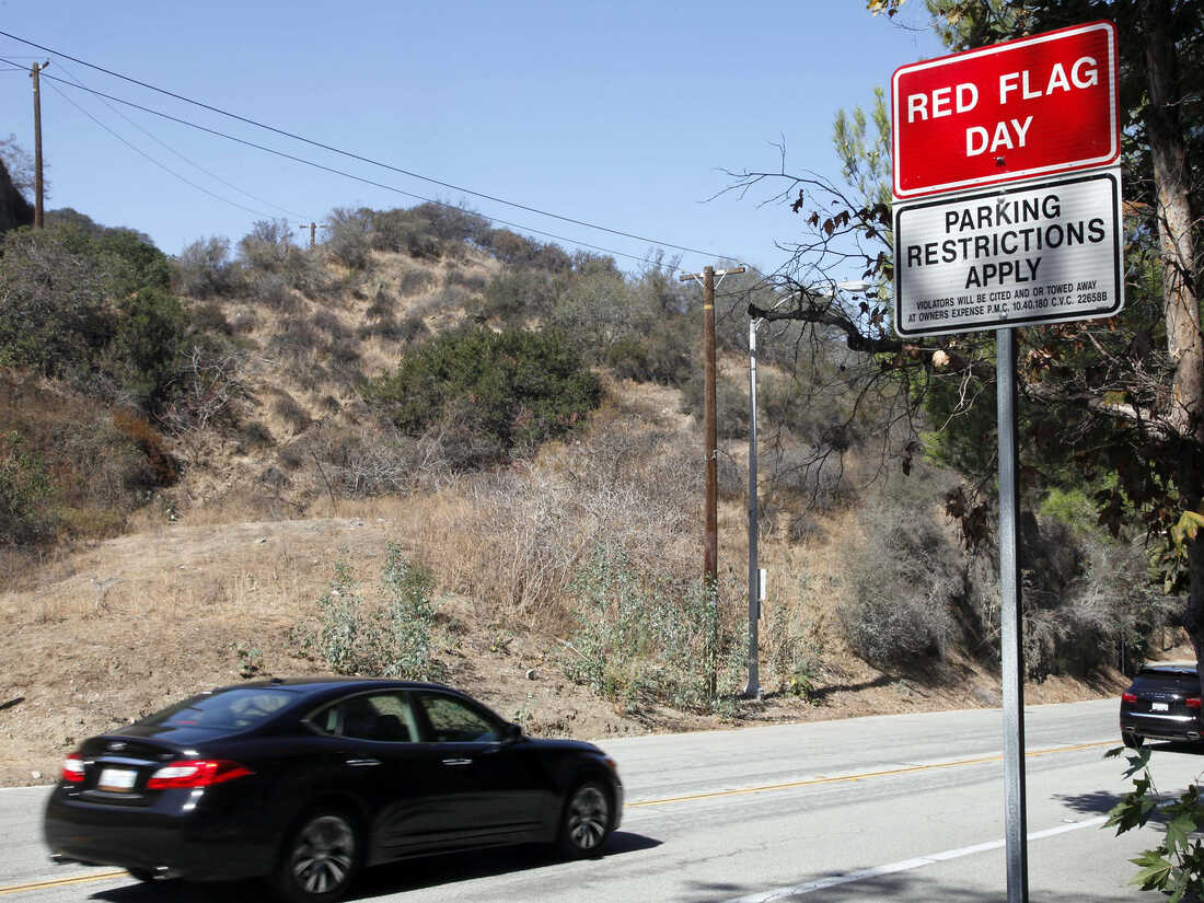
A red flag fire warning sign as seen in October 2013 in Pasadena, Calif. Nick Ut/AP hide caption
A red flag fire warning sign as seen in October 2013 in Pasadena, Calif.
What are the criteria for a red flag warning?
The NWS says red flag events typically require a combination of critical fuel conditions — as determined by land management agencies — and critical weather conditions.
The primary criteria include relative humidity of 15% or less combined with either sustained surface winds or frequent gusts of 25 mph or more. Both conditions must occur simultaneously for at least three hours out of a 12-hour period.
Moore says the main considerations are wind speed, humidity and how dry the ground is, though the exact conditions vary by region.
Every year, each weather forecast office creates an annual operating plan (AOP) that lists out the criteria that they will use when deciding whether to issue a red flag warning or a fire weather watch, Wall explains.

Making weather forecasts is hard. Getting people to understand them is even harder
"For example, 20% humidity in Florida is a very, very different potential fire weather situation than 20% humidity in Nevada," she adds.
Moore says the NWS takes the information and expertise of state and local partners into account when making those decisions.
"We can issue red flag warnings, but we can't issue burn bans or things of that nature, local restrictions, those are all up to the decisions of state and local authorities," he adds. "So we work closely with them to set those thresholds as well."
Where and when do we typically see them?
Red flag conditions can occur in any part of the country at any time of year.
"Almost anywhere has the potential for a non-controlled fire," Wall says.
There is some seasonality to them, she adds. Fire season begins in the southwest sometime around March and continues through the northern Rockies in August and September, while California typically has its fire season in the fall.
"They're pretty common across the country," Moore says. "From my experience as a meteorologist, every area that I've lived in has had red flag warning days."

Hundreds flee from wildfire in South Korean seaside city
Moore notes that there are natural variations in climate patterns and the warnings they require, so he can't necessarily say there's been an upward trend in red flag warnings in recent years.
But more people have access to weather information — whether through iPhone apps or social media posts — than ever before, which he sees as a good thing.
"We want more people to pay attention to the weather," Moore says. "And especially on days that could be impactful to not only yourself but to your community if you're not careful, we want people to be aware of it."

Pacific Gas & Electric cut power to tens of thousands of California residents to prevent the chance of sparking wildfires in October 2020. Rich Pedroncelli/AP hide caption
Pacific Gas & Electric cut power to tens of thousands of California residents to prevent the chance of sparking wildfires in October 2020.
Will the warning system change?
Could a constant stream of red flag warnings and fire weather watches actually have the opposite effect, by potentially desensitizing people to the risk of fires?
Moore says there may be a risk that people will grow accustomed to these warnings, but they still serve an important purpose of heightening awareness about especially dangerous conditicons.
"Want to always reiterate to not do those [basic] things, whether it's dangerous weather conditions or not," Moore says. "But we want to add a little bit more to it as we remind people for those really dangerous days."

Airline passengers could be in for a rougher ride, thanks to climate change
He acknowledges the confusion between the two terms and says that's "something that we're looking at internally."
Wall — who works closely with programs funded by the National Oceanic and Atmospheric Administration (which houses the NWS) — doesn't think the name "red flag warning" should change, since it's very well-established, particularly out west. But she does think the process could be improved.
The NWS has long been working on a "hazard simplification" effort that would narrow down the numbers of watches and warnings to help the public understand them better, she explains.
She says there have been concerns about "over-issuance" in some parts of the U.S., with parts of the West seeing red flag warnings on a daily basis during very dry summers, which has sparked efforts to revamp the system.

A Couple Is Charged In A Deadly Fire Sparked By Their Gender Reveal
Wall is among the experts talking with the NWS about possible solutions, and they advocate using a severity system for red flag warnings in which the risk would either be labeled as moderate or, in the case of the most extreme conditions, very high severity.
She says as important as it is to improve communication and take precautions, she thinks, "really, where we're going ultimately is with fire-adapted communities" and creating communities that are wildfire-resistant.
"I kind of feel like if you keep things relatively simple, you'll do a better job of catching peoples' attention," Wall says. "But in really wildfire-prone areas, it's just the way of life now. You have to be paying attention and you have to be prepared."
- wildfire risk
- weather app
- fire safety
- National Weather Service

Truckee-Tahoe Travel Alert
April 26-28, 2024
We have rain and snow showers in the forecast for Friday, with blue skies returning on Saturday & Sunday. Looking for some fun family activities this weekend? Check out these adventure ideas. Enjoy!
Ski Resort Projected Closing Dates
Sugar Bowl Resort - April 28, 2024
Palisades Tahoe - May 27, 2024
Early Summer Lodging Offer: Get a $100 Gift Card!
Book two or more nights of lodging in Truckee between May 1st and June 21, 2024 and Visit Truckee-Tahoe will give you a $100 Sustainable Truckee Gift Card to shop, dine and play local. E-gift card redeemable at 68 locations in Truckee. Plus, Visit Truckee-Tahoe will also set aside $25 for stewardship projects. Get the offer here!
Read our April E-Newsletter & stay in the know!
Learn all about spring skiing, April events & activities, earth day celebrations, multi-sport days, spring wildflowers and wildlife, & get your guide to skiing The Lake Run! Read the April E-News here.
Top April Events & Festivals
From live music to trail running festivals, Truckee-Tahoe’s vibrant mountain community is alive with year-round events. Don’t miss out on the fun! Join us as we celebrate art, history, environment, and adventure. See what’s on the calendar and plan your trip around one of these great events.
Truckee Weather, Snow, Ski Area Webcams, and Roads
View Truckee's weather forecast, National Weather Service alerts, live traffic cams, highway information, chain control, and more on our Weather, Roads, Cams page.
Read about Truckee Roads, Highways, & Traffic Updates.
Read these insider tips on our Truckee Webcam Shakedown blog.
Check out our snow-free winter trails always plowed after a storm and try one of our new restaurants in Truckee.
Snow and Avalanche Forecast Resources
- National Weather Service Forecast Discussion - Read a summary of Truckee-Tahoe's short and long-term weather and snow forecast. Updated twice daily.
- Daily Avalanche Forecast (Sierra Avalanche Center) - Know how to stay safe in the backcountry. Check the daily avalanche forecast, view recent observations by avalanche professionals and members of the public, and find education resources. Support the Sierra Avalanche Center by making a donation at https://www.sierraavalanchecenter.org/donate .
- Backcountry Skiing Tips & Etiquette (Tahoe Backcountry Alliance) - Follow these tips from our friends at the Tahoe Backcountry Alliance while backcountry skiing and splitboarding.
- Total Accumulated Snowfall from Central Sierra Snow Lab - The Central Sierra Snow Laboratory is a research field station of UC Berkeley located at Donner Pass in the Sierra Nevada. Check total snowfall, precipitation to date, percent of average precipitation, and more.
TART Connect - FREE On-Demand Shuttle in Truckee-Tahoe
TART Connect spring service begins April 8, 2024 and runs through June 27, 2024, with operating hours from 6:30am-10pm. Use the FREE on-demand shuttle to get from your Truckee lodging to anywhere within Truckee town limits. Point to point rides seven days a week. Download the TART Connect APP on Android or Apple , then order a ride and get picked up in as little as 15 minutes. Additional vehicles have also been added to the fleet this winter to help minimize wait times.
Truckee-Tahoe Ski Areas
Truckee-Tahoe ski resorts and cross country ski centers . Check open terrain and mountain conditions.
Top 15 Places for Sledding, Tubing, and Making a Snowman!
Embrace the winter wonderland with unforgettable family experiences! We've got snow on the ground and sledding/tubing is the perfect activity for some thrilling family fun. Resorts are cranking out snow, and it's time to get after it! If you're not skiing or snowboarding, explore these 15 spots for a day filled with snow play.
2024 Sustainable Truckee Visitor Guide
Before you arrive, check out the NEW Sustainable Truckee Visitor Guide for ways to travel sustainably with mindfulness and care for our environment, community, and local economy. The guide lists actions you can take to learn and stay informed, reduce waste, respect our land, water, and wildlife, visit car-free, lower carbon emissions, be a good neighbor, and much more.
Sustainable Truckee Gift Cards
Sustainable Truckee Gift Cards are digital gift cards that can be redeemed at 60+ locations in Truckee: restaurants, breweries, shops, boutiques, yoga and massage studios, wine bars, grocery stores, outdoor guiding companies, and many other local businesses. Buy cards online in just a few clicks and schedule the e-gift for delivery on the date that you choose. An easy gift that friends, family, coaches, and teachers will love. And, every card gives back! Visit Truckee-Tahoe matches 25% of every card for Sustainable Truckee stewardship projects .
Buy Sustainable Truckee Gift Cards in bulk for your employees or team. There's no e-delivery for businesses and organizations that make bulk purchases over $1,000!
Truckee-Tahoe Fishing Reports
Fishing is a year-round activity in Truckee-Tahoe. Before you cast off, get three different fishing reports for Truckee on our fly fishing page . Understand weather conditions and river flows, find out what's biting, and get recommendations on best places to go.
Visitor Guides
Planning a summer visit to Truckee-Tahoe? Read these Visitor Guides to prepare for your trip and understand what to "know before you go."
- Visitor's Guide to Winter Weekend Traffic
- Visitor's Guide to Black Bears and Food Storage
- Visitor’s Guide to Sustainable Transportation
- Visitor's Guide to Boating and Water Recreation
- Visitor's Guide to Wildfire Season
- Visitor's Guide to Planned Power Outages (PSOMs)
- Visitor's Guide to Winter Power Outages
Sign Up for CodeRED, Truckee's Emergency Notification System
Truckee Police Department and the Truckee Fire Protection District use CodeRED Emergency Alert System as a primary method of communication during critical incidents. CodeRED is an opt-in notification system. Alerts may be received as text, email, landline, cell phone, and TTY. Residents and visitors are encouraged to subscribe to CodeRED to stay informed in the event of an emergency.
Register for CodeRED emergency alerts:
- Online at www.truckeepolice.com/disaster-preparedness
- Call 211 or 1-833-DIAL211
- Text ReadyNevadaCounty to 99411 and follow the prompt to register
Trash & Recycling in Bear Country
Learn how to properly recycle and dispose of trash in bear county from Keep Truckee Green. When visiting Truckee-Tahoe, always dispose of trash in a secured, bear-proof garbage receptacle. If a bin is full, pack out your trash - take it home or find the closest empty bin. Remember, proper food storage protects bears and keeps us all safe!
- Be Bearwise on Vacation - Bear Safety
- Tips from Keep Truckee Green
- Download Recycling & Trash Guide (PDF) - English & Spanish
Leave No Trace and Pack Out Your Trash
We invite everyone to help take care of Truckee-Tahoe's beautiful landscape. Please keep our trails, beaches, and public areas clean and litter-free. Pack out all of your trash, and pick up any other trash you see for extra good karma points. Thank you for being a good steward of our mountain town!
Learn how to Recreate Responsibly and Leave No Trace .
Show Your #TruckeeLove
Embrace #TruckeeLove during your visit, the ethos of our mountain town. Smile, give a friendly howdy, and be kind to others. Respect the land, air, and water in the place we call home. Pack a little patience during peak periods and enjoy adventures in the mountains. Kindness is always welcome here!
See the most recent messages from Truckee Fire Protection District , powered by Nixle .
Sign up to receive messages by email & text message.
E-Newsletter Signup
You’re in! Thanks for joining, stay tuned for news and updates.
Oops! Something went wrong while submitting the form
- Book Lodging
- Made Naturally
- Adventure Ideas
- Events, Dine, Shop, Drink, Relax
- Plan Your Stay
- Sustainable Truckee
- About Visit Truckee-Tahoe
- Lodging Industry Partners
- Privacy, Terms & Conditions
- Website Photographers
- Get Our E-Newsletter
Copyright 2023 Visit Truckee-Tahoe
- Credit cards
- View all credit cards
- Banking guide
- Loans guide
- Insurance guide
- Personal finance
- View all personal finance
- Small business
- Small business guide
- View all taxes
You’re our first priority. Every time.
We believe everyone should be able to make financial decisions with confidence. And while our site doesn’t feature every company or financial product available on the market, we’re proud that the guidance we offer, the information we provide and the tools we create are objective, independent, straightforward — and free.
So how do we make money? Our partners compensate us. This may influence which products we review and write about (and where those products appear on the site), but it in no way affects our recommendations or advice, which are grounded in thousands of hours of research. Our partners cannot pay us to guarantee favorable reviews of their products or services. Here is a list of our partners .
Hawaii Travel Discouraged Amid Fires: How to Change Your Plans

Many or all of the products featured here are from our partners who compensate us. This influences which products we write about and where and how the product appears on a page. However, this does not influence our evaluations. Our opinions are our own. Here is a list of our partners and here's how we make money .
Wildfires in Hawaii continue to cause devastation, displacing thousands of residents, destroying property, closing roads and, tragically, leading to the deaths of dozens of people on the island of Maui.
The situation has also prompted the evacuation of many tourists from the island while leaving uncertainty for those planning trips in the coming days and weeks.
President Joe Biden approved a disaster declaration for the state on Thursday.
As firefighters and other emergency responders continue to help with the catastrophic damage, state officials strongly discourage nonessential travel to Maui.
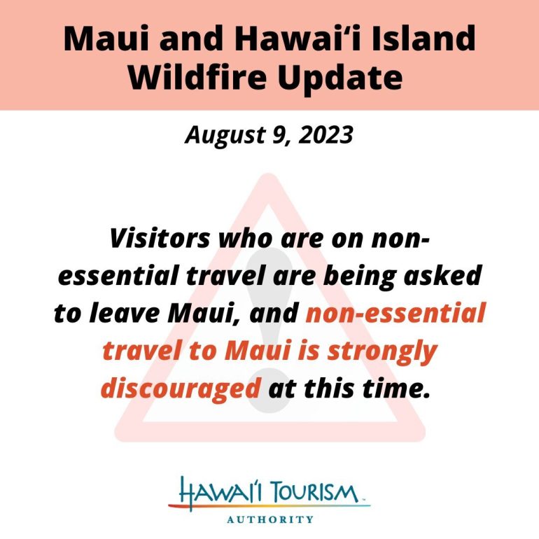
(Image courtesy of Hawaii Tourism Authority)
This could affect travel in the coming weeks.
Flexible airline policies in place
To assist with the evacuation efforts, airlines have been selling steeply discounted tickets to help travelers and residents more easily depart.
Numerous airlines, including Hawaiian Airlines , Southwest Airlines and Alaska Airlines , have sold $19 one-way tickets from Maui to cities on other islands, including Honolulu.
Airlines have also issued travel alerts, which typically allow even customers with restrictive tickets, such as basic economy, to make changes, cancel or get a refund. Airlines frequently take this step when there’s a natural disaster and travel is complicated or discouraged.
Southwest, for instance, says customers with reservations with trips to, from or through Kahului (Maui) and Hilo (Hawaii Island), Honolulu (Oahu), Kona (Hawaii Island), and Lihue (Kauai) can alter plans, rebook or travel standby within 14 days of the original flight date without any extra charges.
Other airlines have travel advisories in place, too, making change policies more flexible.
Keep an eye on your airline’s website for updated alerts if you have plans to travel to Maui in the upcoming days. Check your reservation online or in the airline’s app to see if your trip is affected. You may be able to make a change online without waiting to speak with a customer service agent over the phone.
When will Maui be open again?
As emergency responders continue to contain the wildfires in Maui, it’s still unclear when the island will be safe again for tourists to visit.
Some hotels on Maui have temporarily shuttered operations and will remain closed for the coming days.
For instance, the Hyatt Regency Maui Resort and Spa has an advisory on its website that states it’s closed to arrivals and not accepting guests through Aug. 17. It’s refunding deposits and prepayments for even those guests who made nonrefundable reservations.
The Hawaii Tourism Authority encourages any travelers with plans to visit Maui in the next few weeks to check with their airlines and hotels about the travel status.
“In the days and weeks ahead, our collective resources and attention must be focused on the recovery of residents and communities that were forced to evacuate their homes and businesses,” the agency said in an advisory on its website.
Can you use travel insurance for Hawaii wildfires?
Travelers planning to visit Maui in the coming weeks may wonder whether travel insurance might help.
Generally, travel insurance policies will not cover cancellations or evacuation costs related to a natural disaster if the customer purchases the policy after the disaster begins.
However, if you have a policy purchased before the wildfires began, then you may be able to recoup losses related to trip cancellation, interruption, or — for those who have been on Maui this week and had to leave suddenly — emergency evacuation.
Travel insurance can help you recoup prepaid expenses such as flights or hotel costs if the emergency prevented you from moving forward with your trip.
If you're a traveler without a travel insurance plan with an upcoming trip to Maui, it’s a good time to check if the credit card you used to book your trip offers trip protection benefits . This might be of help if you end up needing to cancel.
» Learn more: How do travel insurance claims work?
The bottom line
The situation in Maui will likely remain fluid for weeks as the community and officials deal with the aftermath of this week’s wildfires.
If you have travel planned to the island within the coming weeks, closely monitor updates from your airline, hotel and the Hawaii Tourism Authority to make the best decision.
How to maximize your rewards
You want a travel credit card that prioritizes what’s important to you. Here are our picks for the best travel credit cards of 2024 , including those best for:
Flexibility, point transfers and a large bonus: Chase Sapphire Preferred® Card
No annual fee: Bank of America® Travel Rewards credit card
Flat-rate travel rewards: Capital One Venture Rewards Credit Card
Bonus travel rewards and high-end perks: Chase Sapphire Reserve®
Luxury perks: The Platinum Card® from American Express
Business travelers: Ink Business Preferred® Credit Card

on Chase's website
1x-5x 5x on travel purchased through Chase Travel℠, 3x on dining, select streaming services and online groceries, 2x on all other travel purchases, 1x on all other purchases.
60,000 Earn 60,000 bonus points after you spend $4,000 on purchases in the first 3 months from account opening. That's $750 when you redeem through Chase Travel℠.

1.5%-6.5% Enjoy 6.5% cash back on travel purchased through Chase Travel; 4.5% cash back on drugstore purchases and dining at restaurants, including takeout and eligible delivery service, and 3% on all other purchases (on up to $20,000 spent in the first year). After your first year or $20,000 spent, enjoy 5% cash back on travel purchased through Chase Travel, 3% cash back on drugstore purchases and dining at restaurants, including takeout and eligible delivery service, and unlimited 1.5% cash back on all other purchases.
$300 Earn an additional 1.5% cash back on everything you buy (on up to $20,000 spent in the first year) - worth up to $300 cash back!

on Capital One's website
2x-5x Earn unlimited 2X miles on every purchase, every day. Earn 5X miles on hotels and rental cars booked through Capital One Travel, where you'll get Capital One's best prices on thousands of trip options.
75,000 Enjoy a one-time bonus of 75,000 miles once you spend $4,000 on purchases within 3 months from account opening, equal to $750 in travel.

- Skip to main content
- Skip to "About this site"
Language selection
Search travel.gc.ca.
Help us to improve our website. Take our survey !
Travel advice and advisories by destination
COVID-19: travel health notice for all travellers
The Government of Canada’s official source of travel information and advice, the Travel Advice and Advisories help you to make informed decisions and travel safely while you are outside Canada. Check the page for your destination often, because safety and security conditions may change. See Travel Advice and Advisories – FAQ for more information.
Where are you going?
Take normal security precautions
Exercise a high degree of caution
Avoid non-essential travel
Avoid all travel
Travel advice from other countries
Travel advice is also provided by the governments of Australia , New Zealand , the United Kingdom and the United States .
Risk Levels
take normal security precautions.
Take similar precautions to those you would take in Canada.
Exercise a high degree of caution
There are certain safety and security concerns or the situation could change quickly. Be very cautious at all times, monitor local media and follow the instructions of local authorities.
IMPORTANT: The two levels below are official Government of Canada Travel Advisories and are issued when the safety and security of Canadians travelling or living in the country or region may be at risk.
Avoid non-essential travel
Your safety and security could be at risk. You should think about your need to travel to this country, territory or region based on family or business requirements, knowledge of or familiarity with the region, and other factors. If you are already there, think about whether you really need to be there. If you do not need to be there, you should think about leaving.
Avoid all travel
You should not travel to this country, territory or region. Your personal safety and security are at great risk. If you are already there, you should think about leaving if it is safe to do so.
Places the U.S. Government Warns Not to Travel Right Now
You may want to reconsider traveling to these countries right now.
Do Not Travel to These Countries

Getty Images
Crime, civil unrest and terrorism are common risk factors for countries that end up on the State Department's "Do Not Travel" advisory list.
In 2024, tourism across the globe is “well on track” to return to pre-pandemic levels, according to projections by UN Tourism.
Global conflicts and natural disasters , ranging from a series of coups across Africa to catastrophic earthquakes in the Middle East affected international travel patterns throughout 2023. Still, international tourist arrivals reached 87% of pre-pandemic levels in 2023, according to estimates by UN Tourism .
In January 2024 alone, about 4.6 million U.S. citizens left the country for international destinations, 17% higher than the same month in 2019, according to the International Trade Administration . But some destinations warrant more caution than others.
On Oct. 19, 2023, following the outbreak of war between Israel and Gaza and flaring tensions in the region, the U.S. State Department issued a worldwide caution advisory due to “increased tensions in various locations around the world, the potential for terrorist attacks, demonstrations or violent actions against U.S. citizens and interests.” Prior to this update, the most recent worldwide caution advisory was issued in 2022 after a U.S. strike killed Ayman al-Zawahiri, Osama bin Laden’s successor as leader of Al Qaeda, causing “a higher potential for anti-American violence.” The worldwide caution advisory remains in effect.
The U.S. State Department also issues individual travel advisory levels for more than 200 countries globally, continually updating them based on a variety of risk indicators such as health, terrorism and civil unrest. Travel advisory levels range from Level 1, which means exercise normal precautions, to Level 4, which means do not travel there.
About 10% of countries – 19 total – have a Level 4: “Do Not Travel” advisory as of Mar. 4. In Level 4 countries, the U.S. government may have “very limited ability” to step in should travelers’ safety or security be at risk, according to the State Department. Crime, civil unrest, kidnapping and terrorism are common risk factors associated with Level 4 countries.
So far in 2024, the State Department made changes to the existing Level 4 advisories for Myanmar, Iran and Gaza, and moved Niger and Lebanon off of the Level 4 list.
Places With a Level 4 Travel Advisory
These are the primary areas the U.S. government says not to travel to right now, in alphabetical order:
Jump to Place: Afghanistan Belarus Burkina Faso Central African Republic Myanmar (formerly Burma) Gaza Haiti Iran Iraq Libya Mali Mexico North Korea (Democratic People's Republic of Korea) Russia Somalia South Sudan Sudan Syria Ukraine Venezuela Yemen
Afghanistan: The Central Asian country is wrestling with “terrorism, risk of wrongful detention, kidnapping and crime,” according to the State Department. U.S. citizens are specifically at risk for wrongful detention and kidnapping. In 2022, the government reinstituted public floggings and executions, and women’s rights are disappearing under Taliban control. The U.S. Embassy in Kabul halted operations in August 2021. Since the Taliban took control , many forms of international aid have been halted . Meanwhile, in 2023, some of the year’s deadliest earthquakes killed more than 2,400 in Afghanistan while the country continues to face a years-long extreme drought.
Belarus: Belarus, which shares a western border with Russia and a southern border with Ukraine, has been flagged for “Belarusian authorities’ continued facilitation of Russia’s war against Ukraine, the buildup of Russian military forces in Belarus, the arbitrary enforcement of local laws, the potential of civil unrest, the risk of detention, and the Embassy’s limited ability to assist U.S. citizens residing in or traveling to Belarus.” The U.S. Embassy in Minsk halted operations in February 2022.
Burkina Faso: Terrorism, crime and kidnapping are plaguing this West African nation. Terrorist attacks may target hotels, restaurants and schools with little to no warning, and the East and Sahel regions of the country are under a state of emergency. In late November 2023, hundreds died in clashes between state security forces and rebels near the country’s border with Mali. In June, more than 2 million people in Burkina Faso were displaced due to “violence linked to al-Qaida and the Islamic State group.”
Central African Republic: While there have not been specific incidents of U.S. citizens targeted with violence or crime, violent crime and sudden closure of roads and borders is common. The advisory states that “Embassy Bangui’s limited capacity to provide support to U.S. citizens, crime, civil unrest, and kidnapping” is a factor in its assessment. Recent data from UNICEF suggests the country has the worst drinking water accessibility of all countries in 2022.
Myanmar (Formerly Burma): Armed conflict and civil unrest are the primary reasons to not travel to this Southeast Asian country, which experienced a military coup in early 2021. Limited health care resources, wrongful detentions and “areas with land mines and unexploded ordnance” are also listed as risk factors. After Ukraine and Israel, Myanmar had the highest conflict-related death toll in 2023.
Gaza : Hamas, a foreign terrorist organization as designated by the State Department, controls much of the Gaza Strip, which shares borders with both Israel and Egypt. On Oct. 7, 2023, Hamas fighters broke across the border into Israel, killing hundreds of civilians and soldiers in a brazen attack that stunned Israelis. On Oct. 10, Israel hit the Gaza Strip with “the fiercest air strikes in its 75-year conflict” according to Reuters . The conflict has since escalated into war between Israel and Hamas, with regular Israeli airstrikes leading to extensive civilian casualties in Gaza. As of mid-December, nearly 85% of Gaza’s population were displaced from their homes, according to UN estimates . The region continues to face shortages of food , water, electricity and medical supplies , with conditions deemed “far beyond a humanitarian crisis.” The State Department warns of terrorism and armed conflict within Gaza’s borders.
Haiti: In July 2023, the Department of State ordered all non-emergency U.S. government personnel and family members to leave the U.S. Embassy in Port-au-Prince in response to the increased risk of kidnapping and violent crime in the country , as well as armed conflict between gangs and police. The travel advisory states that cases of kidnapping “often involve ransom negotiations and U.S. citizen victims have been physically harmed during kidnappings.” The travel advisory also states that “U.S. citizens in Haiti should depart Haiti as soon as possible” given “the current security situation and infrastructure challenges.” A series of gang attacks in late September 2023 caused thousands to flee their homes, and many aid groups have been forced to cut or suspend operations amid escalating violence in recent months.
Iran: Terrorism, kidnapping and civil unrest are risk factors for all travelers to Iran, while U.S. citizens are specifically at risk for “arbitrary arrest.” U.S.-Iranian nationals such as students, journalists and business travelers have been arrested on charges of espionage and threatening national security. Executions in Iran rose sharply between 2021 and 2022, bringing the country’s total to nearly 580 people over the year, according to a report by Amnesty International released in May 2023.
Iraq: The State Department cites “terrorism, kidnapping, armed conflict [and] civil unrest” as cause for the country’s Level 4 distinction. Iraq’s northern borders, and its border with Syria, are especially dangerous. Since the escalation of conflict in neighboring Israel in October, there has been an increase in attacks against Iraqi military bases, which host U.S. troops and other international forces. In October 2023, non-emergency U.S. government personnel and eligible family members were ordered to leave the U.S. embassy in Baghdad.
Libya: Following the end of its dictatorship over a decade ago, Libya has been wrought with internal conflict between armed groups in the East and West. Armed conflict, civil unrest, crime, kidnapping and terrorism are all risk factors. U.S. citizens have been targets of kidnapping for ransom, with terrorists targeting hotels and airports frequented by Westerners. The U.S. Embassy in Tripoli halted operations in 2014. In mid-September 2023, floods, which some say were intensified by climate change , killed thousands in eastern Libya. Clashes between armed factions escalated across the country in the latter half of 2023, including in the capital city of Tripoli and in Benghazi.
Mali: After experiencing military coups in 2020 and 2021, crime, terrorism and kidnapping are all prevalent threats in this West African landlocked nation. In July 2022, non-emergency U.S. government employees and their families were ordered to leave the country due to higher risk of terrorist activity. A U.N. report in August 2023 said that military groups in the country, including both Mali security forces and possibly Russian Wagner mercenaries, were spreading terror through the use of violence against women and human rights abuses. Democratic elections were supposed to occur in February 2024, but Mali’s military junta postponed the plans indefinitely. In December, the U.N. officially ended a decade-long peacekeeping presence in the country, which had been among the agency’s deadliest missions, with hundreds of the mission personnel killed since 2013.
Mexico: Each state in Mexico is assessed separately for travel advisory levels. Six of the 32 states in Mexico are designated as Level 4: Colima, Guerrero, Michoacan, Sinaloa, Tamaulipas and Zacatecas. Crime and kidnapping are listed as the primary risk factors throughout the country. Nearly 112,000 people were missing across the country as of October, a number the U.N. has called “alarming.”
North Korea (Democratic People’s Republic of Korea): U.S. passports are not valid for travel “to, in, or through” this country, home to one of the world's longest-running dynastic dictatorships. The travel advisory states that the Level 4 distinction is due to “the continuing serious risk of arrest and long-term detention of U.S. nationals.” In July 2023, a U.S. soldier fled across the border into North Korea, where he is believed to be in North Korean custody, the first American detained in the North in nearly five years. He was returned to U.S. custody in September 2023.
Russia: The travel advisory for Russia cites its invasion of Ukraine , harassment of U.S. citizens by Russian government officials and arbitrary law enforcement as a few of the reasons for the Level 4 designation. Chechnya and Mount Elbrus are specifically listed as Level 4 regions. Terrorism, civil unrest, health, kidnapping and wrongful detention are all noted as risks.
Russia Invades Ukraine: A Timeline

Somalia: A severe drought resulting from five failed rainy seasons in a row killed 43,000 people in 2022, and caused a famine amid conflict with Islamist insurgents . Violent crime is common throughout Somalia , pirates frequent its coast off the Horn of Africa, and medical facilities, where they exist, have limited capacity. Crime, terrorism, civil unrest, health and kidnapping are all risk factors. In January 2024, some passengers aboard a U.N.-contracted helicopter were taken hostage by al-Shabaab militants after the vehicle crashed in central Somalia.
South Sudan: Crime, kidnapping and armed conflict are the primary risk factors for South Sudan, which separated from Sudan in 2011, making it the world’s newest country . Weapons are readily available, and travelers have been victims of sexual assault and armed robbery.
Sudan: The U.S. evacuated its embassy in Khartoum in April 2023, and the country closed its airspace due to the ongoing conflict in the country, only permitting humanitarian aid and evacuation efforts. Fighting has escalated in the region between two warring generals seeking to gain control after a military coup in 2021 ousted the country’s prime minister. Civil unrest is the primary risk factor for Africa’s third largest country by area. Crime, terrorism, kidnapping and armed conflict are also noted. The International Criminal Court began investigating alleged war crimes and violence against African ethnic groups in the country in 2023. Millions have fled their homes due to conflict, and the U.N. has said its efforts to provide aid have been hindered by a lack of support, safety and resources. As recently as December 2023, the United Nations warned of catastrophic famine , with millions of children at-risk for malnutrition .
Syria: The advisory states that “No part of Syria is safe from violence,” with terrorism, civil unrest, kidnapping, armed conflict and risk of unjust detention all potential risk factors. U.S. citizens are often a target for kidnappings and detention. The U.S. Embassy in Damascus halted operations in 2012. Fighting in neighboring Israel has escalated since October, and the conflict has spilled over into Syria, where the U.S. has carried out air strikes following drone and rocket attacks against American troops in Syria and Iraq, triggered by the Israel-Hamas war.
Ukraine: Russian setbacks in their invasion of Ukraine buoyed hopes in Ukraine in 2023. However, Ukraine is a Level 4 country due to Russia’s invasion, with crime and civil unrest also noted as risk factors. The country’s forces shot down two Russian fighter jets on Christmas Eve 2023, in a move Ukrainian President Volodymyr Zelenskyy said “sets the right mood for the entire year ahead.”
Venezuela: Human rights abuses and lack of health care plague this South American nation, which has been in a political crisis since 2014. In 2019, diplomatic personnel were withdrawn from the U.S. Embassy in Caracas. Threats in the country include crime, civil unrest, kidnapping, wrongful detention and poor health infrastructure.
Yemen: Six of the nine risk factors defined by the State Department – terrorism, civil unrest, health risks, kidnapping, armed conflict and landmines – are all present in Yemen. Despite private companies offering tourist visits to the Yemeni island of Socotra, the U.S. government argues those arranging such visits “are putting tourists in danger.” Civil war and cholera are also both present throughout the country. The U.S. Embassy in Sanaa halted operations in 2015. The country has experienced a relative lull in the civil war fighting, but as peace negotiations have gotten traction, flare ups in the fighting have jeopardized progress. Most recently, the U.S. and U.K. have carried out a series of airstrikes in the country, targeting Iran-backed Houthi sites.
Other Countries to Watch
Since Jan. 1, the State Department has updated travel advisories for 17 different countries as well as for the West Bank and Gaza, adding information about specific regions or risk factors, or simply renewing an existing advisory. Travel advisory levels can change based on several factors in a nation, such as increased civil unrest, policies that affect human rights or higher risks of unlawful detention.
The State Department has given about 25 countries an assessment of Level 3, meaning it recommends people “reconsider travel” to those destinations.
On Oct. 14, one week after the deadly Hamas attack on Israel, Israel and the West Bank were both moved from Level 2 to Level 3, while Gaza remains at Level 4. The region’s travel advisory was updated in November to reflect travel restrictions for certain government employees who have not already left the area, and it was updated again on Jan. 3.
Following the outbreak of the Israel-Hamas war in early October, the U.S. State Department raised Lebanon ’s travel advisory level from a Level 3 to a Level 4 level due to “the unpredictable security situation related to rocket, missile, and artillery exchanges” between Israel and Hezbollah or other militant groups. In December, the U.S. Embassy in Beirut returned to normal staffing and presence, and on Jan. 29, the country was moved back to Level 3. Crime, terrorism, armed conflict, civil unrest, kidnapping and unexploded landmines are listed as the country’s primary risk factors. However, the country’s borders with Syria and with Israel, as well as refugee settlements within Lebanon, are specifically noted as Level 4 regions.
China became a Level 3 country in late 2020, with an update in December 2022 citing “the surge in COVID-19 cases, arbitrary enforcement of local laws, and COVID-19-related restrictions” as the reason for the advisory. In June 2023, the Hong Kong Special Administrative Region (SAR) was moved from the Level 3 to the Level 2 list, but travelers are still advised to be cautious in the area due to “arbitrary enforcement of local laws.” Meanwhile, Macau remains at Level 3.
Following an attempted coup in August 2023, Niger was elevated to Level 4 in August and the Department of State ordered all non-emergency U.S. government personnel and family members to leave the U.S. Embassy in Niamey. In early January 2024, the overall risk level for the country was lowered back to Level 3. Despite the new classification, the State Department still asks non-emergency government personnel and eligible family members to depart the country.
In mid-December 2023 there was an explosion at Guinea’s main fuel depot which has since affected access to health care and basic goods and services. The country was subsequently designated a Level 3 nation after having previously been Level 2. Concerns about civil unrest, health, crime and fuel shortages impacting local infrastructure were listed as the primary risk factors contributing to the change.
Several Level 3 countries are among the worst countries for human trafficking, as designated by the State Department’s annual Trafficking in Persons Report . Level 3 countries on this list include Papua New Guinea, Guinea Bissau, China and Chad. There are also nine Level 4 countries designated as among the worst for human trafficking: Afghanistan, Belarus, Iran, Myanmar, North Korea, Russia, Syria, South Sudan and Venezuela.
Over 70 countries are currently at Level 2, meaning the State Department recommends travelers “exercise increased caution” when traveling to those destinations.
Botswana became the newest Level 2 country on Feb. 26 after having previously been Level 1, with crime noted as the primary risk factor.
France, which saw nationwide protests throughout 2023, has civil unrest and terrorism noted as risk factors for its Level 2 status, and Sweden’s Level 2 status is associated with risks of terrorism.
The Level 2 travel advisory for the Bahamas was updated in January to reflect water safety concerns. The advisory warns that “activities involving commercial recreational watercraft, including water tours, are not consistently regulated” and notes that government personnel are “not permitted to use independently operated jet-ski rentals on New Providence and Paradise Islands.” It also warns visitors to be mindful of sharks, weather and water conditions. The advisory also says that crime is a primary risk factor with gang-on-gang violence contributing to high homicide rates in some areas. Visitors are asked to “be vigilant” and to not physically resist robbery attempts.
Bangladesh 's Level 2 travel advisory was updated in October 2023 to add a note about the country’s general election , which took place Jan. 7, 2024. The advisory states “demonstrations intended to be peaceful can turn confrontational and escalate into violence.” The U.S. has since claimed the country’s election was not free nor fair.
In November 2023, several Level 2 travel advisories were updated with new cautionary information. The advisory for Ghana was updated to reflect threats against LGBTQI+ travelers specifically, noting “anti-LGBTQI+ rhetoric and violence have increased in recent years.” Meanwhile, the advisory for South Africa was updated in February to note that routes recommended by GPS may be unsafe with higher risk for crime.
Turkmenistan was moved off of the Level 2 list to become the newest addition to the Level 1 list on Jan. 22, meaning normal precautions are recommended but there are no risk factors causing travelers to practice increased caution.
The State Department asks travelers to pay attention to travel advisory levels and alerts , review country information pages for their destinations and read related country security reports before going abroad.
Join the Conversation
Tags: Russia , Ukraine , Travel , Coronavirus , Travel Tips , Israel , Gaza , violence , Civil War , crime , kidnapping
Recent Articles
Best countries.

Education News

Best Countries Rankings
- # 1 Switzerland
- # 5 Australia
- # 5 United States
Health News Bulletin
Stay informed on the latest news on health and COVID-19 from the editors at U.S. News & World Report.
Sign in to manage your newsletters »
Sign up to receive the latest updates from U.S News & World Report and our trusted partners and sponsors. By clicking submit, you are agreeing to our Terms and Conditions & Privacy Policy .
You May Also Like
Switzerland is world's best country.
Julia Haines Sept. 6, 2023

Photos: Best Countries Around the World
Sept. 6, 2023

The 25 Best Countries in the World
Elliott Davis Jr. Sept. 6, 2023

US Senator Questions Whether State Dept Properly Assessing Israel Conduct
Reuters April 28, 2024

Kyiv's Top General Says Fighting in East Ukraine Worsens, Troops Fall Back

Current Road Advisories and Information
This page provides additional information during significant events impacting travel on BC highways.
- Check DriveBC , your best source of current road information
- Check EmergencyInfoBC for information about provincial emergencies
- Check News Releases for Travel Advisories
Although less impactful now, wildfires continue to occur in parts of B.C., potentially impacting driving conditions. As British Columbia progresses into fall and winter, further hazards may emerge, particularly rain and flood related.
On this page:
South Okanagan – Summerland Rockslide
This section of highway was closed Aug. 28, 2023 because of a rockslide when approximately 3,000 cubic metres of material came down.
Highway 97 is generally OPEN to two lanes of traffic, one in each direction, subject to short scheduled and unscheduled closures.
As part of the plan to expedite the work, intermittent 20-minute closures will continue during non-peak hours (9 a.m. to 3 p.m.), to support additional smaller blast events as needed.
Blasting will make short closures necessary . Closures for blasting can be expected regularly. The schedule is contingent on ground conditions which are revealed by previous blasts, and each blast requires varying degrees of preparation, so blasts may not occur on the same day each week. The public will be notified as early as possible prior to each blast through DriveBC.ca
Oversize Loads
Daily traffic control on site. Typical travel delays observed are 2-3 minutes or less. Oversize loads are permitted through the site. These loads must be prescheduled prior to arrival with traffic control personnel on site.
Find further information on the Summerland Rockslide project page .
Check for current highway condition and event information: DriveBC
More Resources
Related links.
- News Releases and Travel Advisories
- B.C.’s response to floods and mudslides
- Resource Roads – Information & Closures
- Emergency Info BC
- Canadian Weather Radar Map
- BC Wildfire Service
- Current Wildfire Situation
- FireSmart Homeowner’s Manual
- BC Air Quality
- Smoke Forecasts
- Get prepared for wildfire
- BC on Fire: How We Help Battle the Blaze
- What You Need to Know About Travelling During BC Wildfires

US issues level 3 travel advisory to China amid safety concerns. Here's what to know
Are you thinking about traveling to China to visit or study abroad? The U.S. government suggests reconsidering your trip for now.
According to the U.S. Department of State , traveling to China is under a level 3 travel advisory , warning Americans to reconsider. The State Department has four warning levels. The fourth is “Do not travel.”
Is it safe to travel to China right now?
The U.S. is asking Americans to reconsider traveling to China due to various reasons, including concerns about health and safety, such as the prevalence of contagious diseases like COVID-19, as well as political tensions or security risks in certain regions.
As of April 12, there are some specific areas that the U.S. is asking people to reconsider travel to. Those areas include:
- Mainland China due to the arbitrary enforcement of local laws, including exit bans and the risk of wrongful detentions.
- Exercise increased caution when traveling to the Hong Kong SAR due to the arbitrary enforcement of local laws.
- Reconsider travel to the Macau SAR due to a limited ability to provide emergency consular services.
Additionally, the U.S. government may issue travel advisories based on factors like civil unrest, natural disasters, or other hazards that could affect travelers' well-being.
Americans detained in China
Mark Swidan — a man from Houston, Texas — has been detained in China for over 10 years on drug charges. According to The Texas Tribune , Swidan was detained in China in 2012 while on a trip looking for materials for his home and business in Houston. Chinese authorities arrested him after his driver and translator were found in possession of drugs. The driver blamed Swidan, who is accused of trafficking and manufacturing methamphetamine.
A review of Swidan’s case said there were no drugs on him or in his hotel. Last year, the Republic of China’s Jiangmen Intermediate Court denied Swidan’s appeal and upheld his death penalty with a two-year suspended death sentence.
Other Americans considered wrongfully detained include Chinese American businessman Kai Li from Long Island, N.Y., and California pastor David Lin.
What countries have a Level 3 travel warning?
- Trinidad & Tobago
- El Salvador
- South Sudan
- Democratic Republic of the Congo
- Papua New Guinea
- Saudi Arabia
What countries have a Level 4 travel warning?
- Afghanistan
- Central African Republic
- North Korea (Democratic People's Republic of Korea)
- Burkina Faso
Traveling abroad? Here are some safety tips
U.S. citizens are encouraged to enroll in the State Department’s free Smart Traveler Enrollment Program and to prepare contingency plans for emergencies.
Safety tips if you're traveling outside the U.S.:
- Don't travel alone.
- Be aware of your surroundings.
- Keep a low profile.
- Try not to be flashy.
- Avoid going to places at night, especially by yourself.
This article originally appeared on Austin American-Statesman: US issues level 3 travel advisory to China amid safety concerns. Here's what to know
")
El Paso weather: Expect strong winds, dust to impact driving conditions

El Pasoans will have to brace for another round of strong winds and blowing dust on Thursday, April 25.
A wind advisory is in place from 11 a.m. to 9 p.m. for 25 to 40 mph wind speeds and up to 60 mph gusts, according to the National Weather Service.
Some neighboring counties in New Mexico will also see a high wind warning.
Peak gusts will be in the afternoon, from 2 to 8 p.m., which could cause damage to trees, triggering possible power outages.
Traveling may also be difficult. The wind is expected to kick up dense dust from 1 to 7 p.m., with visibility as low as a half mile in some parts of the region. Some of the most dust-prone areas are Loop 375, US-54 near Alamogordo, and Interstate 10 between Lordsburg, New Mexico and Van Horn, Texas, according to the National Weather Service.
El Paso will also be under a red flag warning for elevated fire risk for dry and windy conditions. People are cautioned to avoid outdoor activities involving flames or sparks.
The wind will be back on Saturday, April 27, though speeds will be slightly weaker. Top speeds will reach 30 mph, and gusts will reach 40 mph.
While El Paso and its surrounding counties have had their share of strong wind , some relief is in sight. The middle of May usually marks the transition from wind to warmer temperatures, Jason Laney, meteorologist at the National Weather Service, said.
“Within the next several weeks we will likely start flirting with the 100-degree mark,” Laney said.
More: How to manage spring allergies in El Paso amid dusty winds
New Mexico weather
Northern Dona Ana County: Sunny. Patchy blowing dust this afternoon. Very windy with highs in the upper 70s. Southwest winds 25 to 30 mph, increasing to 30 to 40 mph with gusts up to 50 mph this afternoon.
Otero County: Will be under the High Wind warning, with Cloudcroft getting the strongest gusts.
The Sacramento Mountains, West Central Tularosa Basin and White Sands are expected to get 30 to 40 mph winds with gusts of up to 60 miles per hour.
More: El Paso braces for more spring winds, dust: National Weather Service
Update April 12, 2024
Information for u.s. citizens in the middle east.
- Travel Advisories |
- Contact Us |
- MyTravelGov |
Find U.S. Embassies & Consulates
Travel.state.gov, congressional liaison, special issuance agency, u.s. passports, international travel, intercountry adoption, international parental child abduction, records and authentications, popular links, travel advisories, mytravelgov, stay connected, legal resources, legal information, info for u.s. law enforcement, replace or certify documents.
Share this page:
Israel, the West Bank and Gaza Travel Advisory
Travel advisory april 11, 2024, see individual summaries.
Updated with information on travel restrictions for U.S. government employees under Chief of Mission security responsibility.
Do Not Travel To :
- Gaza due to terrorism and armed conflict
Reconsider Travel To :
- Israel due to terrorism and civil unrest
- West Bank due to terrorism and civil unrest
Country Summary: Terrorist groups, lone-actor terrorists and other violent extremists continue plotting possible attacks in Israel, the West Bank, and Gaza. Terrorists and violent extremists may attack with little or no warning, targeting tourist locations, transportation hubs, markets/shopping malls, and local government facilities. Violence can occur in Israel, the West Bank, and Gaza without warning.
Some areas have increased risk. Read the country information page for additional information on travel to Israel and the West Bank, and Gaza.
Visit the CDC page for the latest Travel Health Information related to your travel.
If you decide to travel to Israel, the West Bank, and Gaza.
- Visit our website for Travel to High-Risk Areas .
- Check the most recent Alerts at the Embassy website for the latest information on travel in all of these areas.
- Maintain a high degree of situational awareness and exercise caution at all times, especially at checkpoints and other areas with a significant presence of security forces.
- Avoid demonstrations and crowds.
- Follow the instructions of security and emergency response officials.
- Beware of and report suspicious activities, including unattended items, to local police.
- Learn the location of the nearest bomb shelter or other hardened shelter. Download the Home Front Command Red Alert application for mobile devices (available on devices within Israel) to receive real time alerts for rocket attacks.
- Obtain comprehensive travel medical insurance that includes medical evacuation prior to travel. Most travel insurance packages do not cover mental health related illnesses/care.
- Enroll in the Smart Traveler Enrollment Program (STEP) to receive Alerts and make it easier to locate you in an emergency.
- Follow the Department of State on Facebook and Twitter .
- Review the Country Security Report for Israel, the West Bank, and Gaza.
- Prepare a contingency plan for emergency situations. Review the Traveler’s Checklist .
Gaza – Do Not Travel
Do not travel due to terrorism and armed conflict .
The U.S. government is unable to provide routine or emergency consular services to U.S. citizens in Gaza as U.S. government employees are prohibited from traveling there. The Israel Defense Forces (IDF) are conducting large-scale military operations in Gaza against Hamas, a U.S. government-designated foreign terrorist organization, which was responsible for the October 7 attack on Israel. As a result of the armed conflict, the security environment within Gaza and on its borders is extremely dangerous and volatile. The pedestrian crossing between Gaza and Israel was damaged on October 7 and remains closed, and the pedestrian crossing between Egypt and Gaza may close without advance notice depending on the security situation. There are sporadic telecommunication and internet outages within Gaza further inhibiting the ability of residents to obtain information.
Visit our website for Travel to High Risk Areas .
If you decide to travel to Gaza:
- Be prepared for an indefinite stay as the crossings between Gaza with Israel and Egypt can close without advance notice and for long periods during times of unrest and armed conflict.
- Have a plan for entering and departing Gaza that does not rely on U.S. government assistance.
- Households with infants and young children should plan for food and supplies, such as diapers and wipes, formula or baby food, and a change of clothing.
- If you take medication, make sure to have at least five days’ worth at any given time – if you can, we encourage enough for two weeks beyond your scheduled trip and have a copy of your prescriptions handy.
- If you use assistive or medical devices that require a power supply, be sure to find backup power or other ways that will sustain your device or equipment during a power outage.
- Draft a will and designate appropriate insurance beneficiaries and/or power of attorney.
- Discuss a plan with loved ones regarding care/custody of children, pets, property, belongings, non-liquid assets (collections, artwork, etc.), funeral wishes, etc.
- Leave DNA samples with your medical provider in case it is necessary for your family to access them.
Please be sure to visit our website for How to Prepare for a Crisis for information that may be helpful.
Israel – Reconsider Travel
Reconsider travel due to terrorism and civil unrest .
The security situation remains unpredictable, and U.S. citizens are reminded to remain vigilant and take appropriate steps to increase their security awareness as security incidents, including mortar and rocket fire, often take place without warning.
U.S. government employees in Israel under Chief of Mission security responsibility are currently restricted from personal travel to the following locations:
- Within seven miles of the Gaza demarcation line, as well as the cities of Ashdod and Ashkelon;
- Within 2.5 miles of the Lebanese and Syrian borders; and
- Within 1.5 miles of the Israel-Egypt border.
Additional travel restrictions may be imposed on U.S. government employees under Chief of Mission security responsibility, with little to no notice due to increased security issues or threats.
West Bank – Reconsider Travel
U.S. government employees in Israel under Chief of Mission security responsibility are currently restricted from all personal travel to the West Bank, except:
- U.S. government employees can use Routes 1, 90, and 443 at any time.
- U.S. government employees are permitted personal travel to Jericho.
- U.S. government employees are permitted daylight travel to: Inn of the Good Samaritan, An-Nabi Musa, Wadi Qelt Nature Preserve, and St. George’s Monastery along Route 1; and Qumran, Kalia Beach, St. Gerasimos/Khogla Monastery, Al Auju, and Qasr al-Yaud baptismal site along Route 90.
Over the past few months, there has been an increase in settler violence, Israeli military operations, and terrorist attacks.
Additional travel restrictions may be imposed on U.S. government employees under Chief of Mission security responsibility with little to no notice due to increased security issues or threats.
Visit our website for Travel to High Risk Areas .
Travel Advisory Levels
Assistance for u.s. citizens, israel, the west bank and gaza map, search for travel advisories, external link.
You are about to leave travel.state.gov for an external website that is not maintained by the U.S. Department of State.
Links to external websites are provided as a convenience and should not be construed as an endorsement by the U.S. Department of State of the views or products contained therein. If you wish to remain on travel.state.gov, click the "cancel" message.
You are about to visit:
COMMENTS
Saba Travel Advisory: Level 1: Exercise Normal Precautions: October 16, 2023: Take 90 Seconds for Safer Travel. Travel Advisory Levels. TRAVEL ADVISORIES AND ALERTS: THE DETAILS Enroll in STEP. Subscribe to get up-to-date safety and security information and help us reach you in an emergency abroad.
About the Data. The Fire and Smoke Map shows information on particle pollution, fires and smoke plumes: Particle pollution data: Particle pollution, also called fine particulate matter or PM 2.5, is the main type of pollution in smoke.; The Map shows particle pollution data from established air quality monitors operated by air quality agencies, temporary monitors deployed by agencies for smoke ...
What is the guidance around traveling to West Maui? All nonessential travel to West Maui is "strongly discouraged" through the end of August according to Gov. Josh Green's emergency ...
On December 22, 2023, the Hawaiʻi Tourism Authority Board of Directors furthered its ongoing commitment to mālama Maui and support the island's recovery by approving an immediate six-month action plan for 2024 to help address major challenges confronting residents, small businesses, visitor industry providers, Maui's economy, and families ...
Kindly check the operating hours before your visit, as some centers may experience temporary closures during winter months or major holidays. Additional visitor information is available by calling 1.800.547.7842 (Monday -Friday) or submitting your question to us via Ask Oregon. Travel Oregon's first priority is the safety of our residents and ...
State Department Travel Advisory Updates. In order to provide U.S. travelers detailed and actionable information to make informed travel decisions, the Department of State regularly assesses and updates our Travel Advisories, based primarily on the U.S. Centers for Disease Control and Prevention (CDC) Travel Health Notices (THNs) and secondary factors such as commercial flight availability ...
Hawaiian Airlines has a waiver in place for all flights to and from Maui's Kahului Airport between August 9 and August 31, 2023. The state airline has added extra flights to help get travelers and evacuees out of Maui, and it is selling seats through August 20, 2023, for just $19 "to facilitate urgent travel out of Maui.".
The advisory urged people to avoid unnecessary travel to the Maui area so that emergency officials could allow evacuees and people impacted by the wildfires to safely leave the area.
US Wildfire Activity Web Map. description: This map contains live feed sources for US current wildfire locations and perimeters, VIIRS and MODIS hot spots, wildfire conditions / red flag warnings, and wildfire potential. Each of these layers provides insight into where a fire is located, its intensity and the surrounding areas susceptibility to ...
Check out the latest California Wildfire & Travel ConditionsAre there currently wildfires in California?Wildfires are burning in unpopulated areas Butte County (Camp Fire). Firefighters continue to gain the upper hand in containment.A vast majority of the Golden State is currently unaffected by fires.For the latest information on wildfires in the state, visit www.Calfire.ca.gov.
Electronic red flags warn of risky conditions in the next 12 to 24 hours. They differ in timing from a fire weather watch, which warns of the possible development of those conditions in the next ...
Travel warnings have been issued in parts of BC. In Vancouver, the 'very high risk' air quality advisory has been lifted after fires last month but this may not last. You can stay up to date ...
California Wildfire Travel Update. As is typical during the West's fire season, there are several active fires in California. Most are burning in rural, mountainous regions in the inland north and central part of the state. A short portion of Highway 101 north of Santa Barbara is closed due to the Alisal Fire but tourism businesses in the ...
Weather.gov > Active Alerts. Warnings By State. Excessive Rainfall and Winter Weather Forecasts. National River Flooding. Latest Warnings. Thunderstorm/Tornado Outlook. Hurricanes. Fire Weather Outlooks. UV Alerts.
Truckee Police Department and the Truckee Fire Protection District use CodeRED Emergency Alert System as a primary method of communication during critical incidents. CodeRED is an opt-in notification system. Alerts may be received as text, email, landline, cell phone, and TTY.
Airlines have also issued travel alerts, which typically allow even customers with restrictive tickets, such as basic economy, to make changes, cancel or get a refund.
Travel advice and advisories by destination. The Government of Canada's official source of travel information and advice, the Travel Advice and Advisories help you to make informed decisions and travel safely while you are outside Canada. Check the page for your destination often, because safety and security conditions may change. ...
So far in 2024, the State Department made changes to the existing Level 4 advisories for Myanmar, Iran and Gaza, and moved Niger and Lebanon off of the Level 4 list. Places With a Level 4 Travel ...
Read the entire Travel Advisory. Do Not Travel to: Kenya-Somalia border counties and some coastal areas, due to terrorism and kidnapping. Areas of Turkana County, due to crime. Reconsider Travel to: Nairobi neighborhoods of Eastleigh and Kibera, due to crime and kidnapping. Certain areas of Laikipia County, due to criminal incursions and ...
This page provides additional information during significant events impacting travel on BC highways. Check DriveBC, your best source of current road information; Check EmergencyInfoBC for information about provincial emergencies; Check News Releases for Travel Advisories; Although less impactful now, wildfires continue to occur in parts of B.C., potentially impacting driving conditions.
According to the U.S. Department of State, traveling to China is under a level 3 travel advisory, warning Americans to reconsider.The State Department has four warning levels. The fourth is "Do ...
Travel caution advised; fire risk high. Relief expected by mid-May with warmer temps. ... A wind advisory is in place from 11 a.m. to 9 p.m. for 25 to 40 mph wind speeds and up to 60 mph gusts ...
Israel - Reconsider Travel. Reconsider travel due to terrorism and civil unrest. The security situation remains unpredictable, and U.S. citizens are reminded to remain vigilant and take appropriate steps to increase their security awareness as security incidents, including mortar and rocket fire, often take place without warning.