

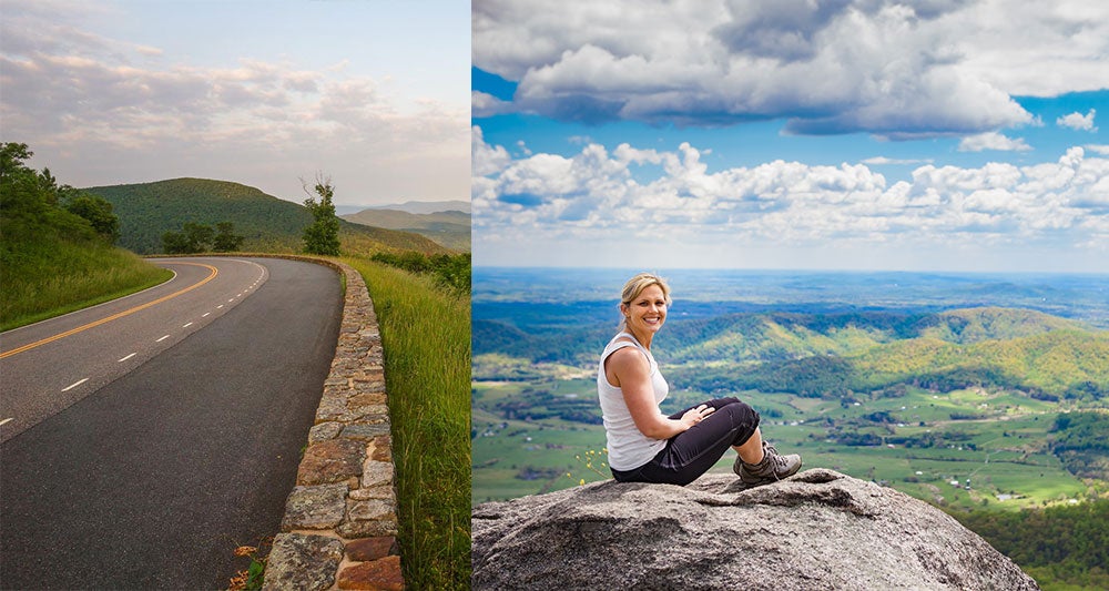
Planning a Skyline Drive road trip
There’s a lot to see, do, and love on this 105-mile scenic byway that cuts north to south across Virginia’s Shenandoah National Park.
Taking in the scenery of Skyline Drive is a bucket-list item for nature lovers and outdoor enthusiasts, and the road attracts more than 1.2 million visitors each year. Many come eager to take in vibrant fall foliage or colorful spring wildflowers.
The road is widely considered one of the most scenic drives in the U.S. The drive from north to south across Virginia’s Shenandoah National Park rewards with overlooks, picnic areas, hiking trails, waterfalls, historic landmarks, and the remains of former homesteads.
Concrete mileposts along Skyline Drive make it easy to keep track of where you are within the national park. Before you pile everyone into the car, note that lodges, restaurants, campgrounds, and convenience stores (known as “waysides” in the park) are closed from late-fall to early-spring. In winter, only the Harry F. Byrd, Sr. Visitor Center is open, and only from Thursday through Monday. However, Skyline Drive is open every day the scenic byway is not impacted by inclement weather.
Everything you need to know about a Skyline Drive road trip
Skyline drive road trip map, our favorite attractions.
- Skyline Drive history
- Front Royal to Thornton Gap
- Thornton Gap to Swift Run Gap
Swift Run Gap to Rockfish Gap
Four Skyline Drive access points—Front Royal, Thornton Gap, Swift Run Gap, and Rockfish Gap—split Shenandoah National Park into three similar-sized districts. The North District is closest to Washington, D.C., attracting visitors motoring in from the city and suburbs. The Central District is home to the park’s two lodges, while the South District is known for more rugged terrain.
There are two visitor centers on Skyline Drive, including Dickey Ridge Visitor Center in the North District and Harry F. Byrd, Sr. Visitor Center in the Central District. There are also three camp stores for snacks, supplies, and souvenirs, one in each of the park’s three districts. For sit-down meals, there are two restaurants at each of the in-park lodges.

Download the mobile app to plan on the go.
Share and plan trips with friends while discovering millions of places along your route.
A scenic trip along Skyline Drive has so much to offer, including sensational views, historic landmarks, and iconic trails—there’s even a signature park dessert. Here are five of our favorite things along Skyline Drive at Shenandoah National Park.
Rapidan Camp : The rustic summer retreat of 31st President Herbert Hoover during the Great Depression is located in the park’s Central District, near milepost 52.8 on Skyline Drive. Three historic cabins alongside the Rapidan River have been restored to their original 1929 appearances.
Appalachian Trail : A lengthy 101-mile segment of the iconic Appalachian Trail criss-crosses Skyline Drive for the full length of Shenandoah National Park. Several popular day hikes, including Mary’s Rock, Stony Man, and Hightop Mountain, include stretches of this trail.
Hawksbill Summit : At an elevation of 4,051 feet, Hawksbill Summit is the highest point in Shenandoah National Park. A popular out-and-back hike to the top starts at milepost 45.5. At the summit, there is a scenic viewing platform and a small stone picnic shelter.
Mile-High Blackberry Ice Cream Pie: While not an attraction per se, you won’t want to leave Skyline Drive without a slice of the park’s delicious signature dessert. In-season, order up a slice at any of the restaurants at Skyland or Big Meadows Lodge (both in the Central District).
Fox Hollow Trail: There are a lot of big views along Skyline Drive, but there’s also a lot of history. This loop hike guides visitors across the former farm of the Fox family, one of more than 400 homesteading families that lived on the rural land before the park was established in 1935.

Skyline drive history
Skyline Drive is a 105-mile scenic byway that crests the Blue Ridge Mountains. Completed in 1939, Skyline Drive meanders north to south across Shenandoah National Park, allowing visitors spectacular views of Virginia’s Shenandoah Valley from more than 75 pull-off overlooks.
More than 500 miles of hiking trails criss-cross Shenandoah National Park, including 101 miles of the famed Appalachian Trail, which generally parallels Skyline Drive. Every now and again, the trail crosses over the scenic byway, then crosses back.
Skyline Drive is especially popular in October when celebrated fall foliage is bursting with vibrant golds and ambers. In peak leaf peeping season, it’s best to seek out Skyline Drive on weekdays, early mornings or late in the day for brilliant golden hour leaves.
A Skyline Drive road trip by segments
Skyline Drive, which snakes from north to south across Shenandoah National Park, has concrete mileposts every one mile. This makes it easy to identify your location in the park, whether you’re in the North District (milepost 0.0 to 31.5), Central District (milepost 31.5 to 65.7), or South District (milepost 65.7 to 105.4).
Ranger-staffed park entrances on Skyline Drive bookend the start and finish of each park district, including Front Royal (milepost 0.6), Thornton Gap (milepost 31.5), Swift Run Gap (milepost 65.7), and Rockfish Gap (milepost 105.4). Here’s what to know about Skyline Drive, which is open to RVs, travel trailers, and horse trailers.
Front Royal to Thornton Gap
The North District of Shenandoah National Park begins where Skyline Drive meets U.S. Route 340 in Front Royal. Enter the park by way of Skyline Drive, then pay the entrance fee of $30 per vehicle at milepost 0.6 (the entrance fee is good for 7 consecutive days). This quiet section of the park runs along Skyline Drive to Thornton Gap at milepost 31.5.
Make the Dickey Ridge Visitor Center (milepost 4.6) your first stop for nature exhibits and a short park film. Kids ages 7 through 12 can complete a Junior Ranger activity booklet to be sworn in as a Junior Ranger and earn a badge. Behind the visitor center, west-facing vistas attract plein-air painters on clear days. You’ll also find restrooms and a picnic area with picnic tables and charcoal grills.
From the visitor center, walk across Skyline Drive to reach the start of the Fox Hollow Trail. This easy 1.2-mile loop hike offers a glimpse into rural mountain life. Stroll past hand-placed rock walls and a historic cemetery filled with burial plots of the Fox family, one of many families that lived on land that later became a part of Shenandoah National Park.
Stop at milepost 21.1 for a 6.5-mile loop hike with scenic views of 93-foot-tall Overall Run Falls , the tallest waterfall in the national park. The falls are best in spring or fall when you’re more likely to reach a tumbling waterfall rather than a trickle, which can be the case on warm summer days.
Mathews Arm Campground (milepost 22.1) is the only campground in the park’s North District. There are 165 sites with picnic tables and fire rings, including 47 sites that can be reserved online. All other sites are first-come, first-served. Three group campsites each allow up to 25 people. All campsites are non-electric with no hookups. There are no showers at this campground.
For sundries and supplies, as well as pre-packaged sandwiches and a grill for burgers and fries, stop in Elkwallow Wayside at milepost 24.1. This convenience store is a helpful resource for day-use visitors and overnight campers. You’ll also find restrooms, camping supplies, and souvenirs, as well as an adjacent picnic area.

Thornton Gap to Swift Run Gap
Shenandoah National Park’s most popular section is the Central District, which runs from the Thornton Gap entrance at milepost 31.5 to the Swift Run Gap entrance at milepost 65.7. There are ranger-staffed pay stations at both entrances. The Central District is home to the park’s two lodges, horseback riding stables, and two campgrounds.
As you enter the Central District, make the super-size Panorama parking area at milepost 31.6 your first stop for restrooms and the trailhead for the Mary’s Rock hike. From here, it’s a 3.7-mile out-and-back hike, mostly along the white-blazed Appalachian Trail, to the top of Mary’s Rock.
Continuing south on Skyline Drive, you will encounter the only restriction in Shenandoah National Park for RVs. The 670-foot-long Mary’s Rock Tunnel at milepost 32.2 has a maximum clearance of 12 feet, 8 inches. There are no clearance restrictions in the park’s North District or South District.
For rock climbers (even newbies), Shenandoah Mountain Guides leads rock climbing adventures at Little Stony Man Cliffs. Not a rock climber? Not a problem. An easy 0.5-mile hike (one-way) starting at milepost 39.1 delivers visitors to rocky outcrops at Little Stony Man Cliffs for sweeping views and rainwater-filled shallow pools.
At milepost 41.7, Skyland , one of two in-park lodges, beckons visitors with 179 guest rooms, stylish suites, and rustic cabins. At an elevation of 3,680 feet, Skyland sits at the highest point on Skyline Drive. There is a gift shop and two on-site restaurants, including Pollock Dining Room , which serves elevated farm-to-fork flavors, and Mountain Taproom , a no-frills grill with pub grub, like chicken wings and burgers.
Skyland is also home to Skyland Stables , which offers 1-hour and 2.5-hour guided horseback trail rides. For small children, hand-guided 15- and 30-minute pony rides are available. Several hiking trails set off from Skyland, including the Millers Head Trail (1.5 miles, out-and-back) and the Appalachian Trail , which leads to views from atop Stony Man Mountain .
More hiking trails call to visitors motoring along Skyline Drive. At milepost 43, the Limberlost Trail is a stroller-friendly 1.25-mile loop on a crushed greenstone surface. This is the only fully-accessible trail at Shenandoah National Park. Further on, hike to the top of Hawksbill Mountain , the highest point in the park at an elevation of 4,051 feet.
The Harry F. Byrd, Sr. Visitor Center is located at milepost 51. An “Iron Mike” statue greets visitors walking in and celebrates the men of the Civilian Conservation Corps who created much of Shenandoah National Park during the Great Depression. A 14-minute video called Shenandoah: The Gift details the formation of the national park. Inside, you’ll find restrooms and a bookstore.
Adjacent to the visitor center is Big Meadows Wayside , a convenience store and souvenir shop, which has restrooms, picnic tables, and a small gas station. It’s also across Skyline Drive from Big Meadows, which hosts periodic night sky programs with local astronomy clubs.
At milepost 51, you’ll also find Big Meadows Lodge , which has 101 guest rooms across the main lodge and historic cabins. There are two on-site restaurants, including Spottswood Dining Room , which serves regional and theme dishes, like the New Deal Roast Turkey Plate, and New Market Taproom , which has casual fare, local beers, and family-friendly trivia nights.
The Big Meadows Campground at milepost 51.2 is the largest campground in the park with 221 campsites, including 168 sites that can be reserved online. All other sites are first-come, first-served. This campground has 51 tent-only sites, as well as two group sites that each allow up to 15 people. All campsites are non-electric with no hookups.
Historic Rapidan Camp , President Herbert Hoover’s summer retreat, can be reached by way of a 4.2-mile out-and-back hike on the Mill Prong Trail , which starts at milepost 52.8. Three original structures, including Creel Cabin, the Prime Minister’s Cabin, and the President’s Cabin (“Brown House”), have been restored to original 1929 appearances.
The Lewis Mountain Campground at milepost 57.5 is the smallest of the four campgrounds at Shenandoah National Park. There are 30 first-come, first-served sites. All campsites are non-electric with no hookups. There are also 15 cabins for rent at Lewis Mountain Campground.

Shenandoah National Park’s South District is cool and calm, but also rugged and mountainous. This section runs from the Swift Run Gap entrance at milepost 65.7 to the Rockfish Gap entrance at milepost 105.4 in Waynesboro. There are ranger-staffed pay stations at both entrances. The South District is home to a campground, as well as the park’s only large group campground.
For big views, plan for a 3-mile out-and-back hike along a southbound stretch of the Appalachian Trail, which you can pick up at milepost 66.7. The forested hike leads to a rocky overlook on Hightop Mountain, the highest point in the national park’s South District.
For snacks and drinks, stop at Loft Mountain Wayside at milepost 79.5. This convenience store, gift shop, and made-to-order grill also has restrooms and picnic tables. From here, you can pick up the easy Frazier Discovery Trail across Skyline Drive for rock scrambles, creek crossings, and scenic overlook views.
The Loft Mountain Campground is also located at milepost 79.5, on the east side of Skyline Drive, atop Big Flat Mountain. This large campground has 207 sites, including 55 sites that can be reserved online. All other sites are first-come, first-served. There are 50 tent-only campsites. All sites are non-electric with no hookups. There is also an on-site camp store.
For large groups, Dundo Group Campground is in the South District, at milepost 83.7. There are three group tent camping sites, each of which can hold up to 20 people. All sites are non-electric and can be booked online up to one year in advance. A large picnic area is located at the south end of the group campground, which has picnic tables, water spigots, and restrooms.
From the Dundo Group Campground, it’s a cinch to reach the Jones Run Trail at milepost 84.1. From here, it’s a 2-mile hike (one-way) to reach 42-foot-tall Jones Run Falls . Bring a towel and water shoes; there are several watering holes on the way for an invigorating splash. For added steps, and more waterfalls, continue on to hike alongside the Doyles River.
You’ll soon reach Doyles River Falls , which includes 63-foot-tall Lower Falls and 28-foot-tall Upper Falls. After the second waterfall, loop back to your starting point by way of the Browns Gap Fire Road and Appalachian Trail. All in, the loop hike alongside Jones Run and Doyles River clocks in at 7 miles.
For sensational views, one of the best—and easiest—hikes in the park is the 1-mile loop that takes hikers to Blackrock Summit for sweeping views across Massanutten Mountain and the Shenandoah Valley. A boulder field allows for a fun rock scramble that delivers even more views. Pick up the trail in the parking area at milepost 84.4.
There is no physical visitor center in the park’s South District, but a mobile visitor center can often be found in-season parked at Beagle Gap at milepost 99.5. Park rangers can suggest hiking trails, answer questions, and provide park maps.

Frequently asked questions
Where does the skyline drive begin and end.
Skyline Drive begins where it meets U.S. 340 in Front Royal. The 105-mile scenic byway meanders north to south, ending at milepost 105.4 in Waynesboro, where Skyline Drive meets U.S. Route 64. From here, Skyline Drive becomes the Blue Ridge Parkway .
How long does it take to drive Skyline Drive?
It takes approximately 3 hours to drive the full length of Skyline Drive.
How much does Skyline Drive cost?
There is a fee of $30 per vehicle (including RVs) or $25 per motorcycle to access Skyline Drive and Shenandoah National Park. The entrance pass is valid for 7 consecutive days. Entrance is free for America the Beautiful pass holders.
How many miles is the Skyline Drive?
Skyline Drive is 105 miles long, and can be accessed by way of four entry points, including Front Royal, Thornton Gap, Swift Run Gap, and Rockfish Gap.
What is the best way to travel Skyline Drive?
Most visitors travel Skyline Drive in a car, but it is also possible to travel by motorcycle. RVs, including motorhomes and travel trailers, are permitted along the full length of Skyline Drive. The only warning is Mary’s Rock Tunnel at milepost 32.2, which has a maximum clearance of 12 feet, 8 inches.
Cycling is also permitted on Skyline Drive. Road bikes are suggested. Be prepared for narrow shoulders and steep inclines along the scenic byway.
What is the best time of year to drive Skyline Drive?
Fall is a popular time of year to travel Skyline Drive to experience colorful fall foliage. Spring is also popular, as this is when wildflowers, like asters, goldenrods, and mountain laurel, are in bloom.
A word of caution about winter on Skyline Drive. Sections or the full length of the scenic byway often close due to inclement weather. To check the current road status, visit Shenandoah National Park’s website and social media channels or opt-in to the park’s alert system by texting SHENALERTS to 888777.
What are the driving conditions on the Skyline Drive?
Skyline Drive is a winding two-lane road with ups and downs. You may encounter blind corners here and there, so stay alert behind the wheel. In winter, Skyline Drive may shut down, in part or in full, due to ice or snow. For current road status, visit Shenandoah National Park’s website or social media channels.
Is it better to drive Skyline Drive north to south?
The most popular direction on Skyline Drive is north to south, from Front Royal to Waynesboro. This is largely due to Front Royal’s proximity to the populous Washington, D.C., area, which is an easy 90-minute drive east of Shenandoah National Park.
Are there restrooms on Skyline Drive?
There are restrooms all along Skyline Drive, including at visitor centers, camp stores, lodges, and picnic areas, though some may be locked when closed for the season. Year-round, you’ll also find restrooms (flush toilets) at the Panorama parking area (milepost 31.6) and a porta-potty at the Beagle Gap parking area (milepost 99.5).
What is the speed limit on Skyline Drive?
The speed limit on Skyline Drive is 35 mph.

Erin Gifford is a freelance travel and outdoor recreation writer. She has written for The Washington Post, Chicago Tribune, AFAR.com , and Parents. She recently published her first hiking guidebook, Hiking with Kids Virginia: 52 Great Hikes for Families . She’s currently on a quest to run a half marathon in every U.S. state.

Plan Your Trip Now
Discover the most incredible people, places, and experiences worth the detour. Click below to start your trip to the Pacific Coast Highway or enter a starting point . Click below to start your trip from to the Pacific Coast Highway.

- Trip guides
- Trip Planner
- Sign up Log in Sign out
- Log in Sign out
- ROADTRIPPERS MEMBERSHIP
- RV RESOURCES
Plan your journey, find amazing places, and take fascinating detours with our app.
We couldn't find an existing Roadtrippers account using that service. Please try signing in with another option or create a new account with Roadpass.
We need your email address to send you trip itineraries and other updates.
Plan Your Visit
in Shenandoah National Park
Know before you go
Plan your visit to Shenandoah National Park, the only national park in Virginia. Skyline Drive is the only road through the park, stretching 105 miles from Front Royal in the north to Waynesboro in the south. You can enter Shenandoah National Park via four access points:
- Front Royal at U.S. 340 near I-66
- Thornton Gap at U.S. 211
- Swift Run Gap at U.S. 33
- Rockfish Gap at I-64 and U.S. 250
What You Should Know About Skyline Drive
It takes about three hours to travel the entire length of the drive on a clear day. The maximum speed limit is 35 mph. As you travel along Skyline Drive you will notice mileposts along the side of the road. These posts help you find your way through the park and help you locate areas of interest. The mileposts begin with 0.0 at Front Royal and continue to 105 at the southern end of the park. For current road conditions or alerts, click here .
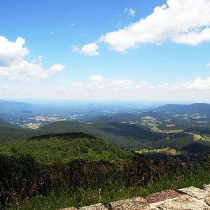
There are 75 overlooks that offer stunning views of the Shenandoah Valley to the west and the rolling piedmont to the east. Wildflowers put on a show all year long – in early spring, look for trillium peeking through the grass. June’s display of azaleas is spectacular. Cardinal flowers, black-eyed susans, and goldenrod keep the color vibrant right into fall, when the leaves begin to change and put on their own fall foliage show.

Watch for Wildlife
Deer, black bear, wild turkey, and a host of other wildlife call Shenandoah home and regularly cross Skyline Drive. Watch carefully for these animals, which may dart across your path without warning.

2022 Entrance Fee Free Days
There will be fee free days in 2022 in all National Park Service sites that charge an entrance fee.
Mark your calendar for these entrance fee–free dates:
- January 17 : Birthday of Martin Luther King Jr.
- April 16: First Day of National Park Week
- August 4: A nniversary of the Great American Outdoors Act
- September 24: National Public Lands Day
- November 11: Veterans Day
Hazardous Weather May Close Skyline Drive
Inclement weather may necessitate closure of Skyline Drive at any time. For current road conditions:
- call the park’s recorded information line: (540) 999-3500, press 1, then press 1 again
- or follow @ShenandoahNPS on Twitter
There’s so much to see!
So, what should i do first.
A Camper’s Guide to Skyline Drive, Virginia’s Most Scenic Highway
The Skyline Drive in Shenandoah National Park winds through the Blue Ridge Mountains, twisting and turning at the base of ancient peaks. The scenic highway is open year-round, providing access to vast wilderness with overlooks, trails, and campgrounds, just off the road. Enjoy the views from your car or park and venture further on foot—it’s up to you.
The park is only half a day’s drive from major cities like New York and Philadelphia. From Baltimore, it’s only two hours, while from Washington, D.C., you can get there in less than one and a half. If you want to get away from the bustling East Coast cities, the Skyline Drive is a stunning road trip and a convenient escape.
Keep it in low gear and take your time. This paved tour of Shenandoah National Park is just the beginning.
Experience the Best of the Skyline Drive

Image from The Dyrt camper Tyler H.
Skyline Drive is the only road through Shenandoah National Park. This 105-mile stretch runs the entire length of the long and narrow park, following the crest of the Blue Ridge Mountains. Some 70 overlooks line Skyline Drive, offering you a scenic view every 1.5 miles on average. With the exception of Old Rage (see hiking below), all attractions, points of interest, trailheads and visitor centers are on Skyline Drive.
The groundwork for Skyline Drive started in 1931, creating thousands of jobs during the Great Depression. In 1934, the first section of this brand-new scenic mountain road was opened. Shenandoah National Park was established a year later, in 1935, and officially opened by President Franklin D. Roosevelt in 1936.
Mileposts line the entire length of Skyline Drive, from MP 0 in Front Royal in the north to MP 105 at the park’s southern end, which incidentally is where the phenomenal Blue Ridge Parkway begins. These regular mileposts make it easy to find trailheads and other destinations.
Prepare for your next adventure by downloading maps. The Dyrt PRO lets you download maps and campgrounds without cell service. “My alternative to using pro would be to drive back out to cell service”.
Skyline Drive Entrance Stations
There are four places where you can enter Skyline Drive and, therefore, Shenandoah National Park.
- Front Royal Entrance Station at mile 0 (near I-66 and off Route 340)
- Thornton Gap Entrance Station at mile 31.5 (off Route 211)
- Swift Run Gap Entrance Station at mile 65.7 (off Route 33)
- Rockfish Gap Entrance Station at mile 105 (off I-64 and Route 250)
There are numerous blind turns and one tunnel, so drive carefully. Additionally, the park is home to thousands of white-tailed deer and hundreds of black bears, so drive carefully and pay attention to the road. The speed limit on Skyline Drive is 35 mph.
Access Visitor Centers from Skyline Drive
The first thing to do when visiting any national park is swinging by one of its visitor centers. There are two Shenandoah National Park Visitor Centers just off of Skyline Drive.
Dickey Ridge Visitor Center
The Dicky Ridge Visitor Center is located on mile 4.6 on Skyline Drive. It’s the first point of interest you’ll encounter when starting your drive in the north. This is also the only visitor center that has that classic national park orientation movie, arguably the best introduction to any park.
Additionally, there are restrooms, an information desk, a bookstore, and exhibits. You can get backcountry permits, publications, and maps here as well.
Harry F. Byrd Visitor Center
On Skyline Drive’s mile 51 lies the Harry F. Byrd Visitor Center, the main visitor center in Shenandoah National Park. It’s situated right across from Big Meadows, its large windows offering great views of this huge grassland.
Here, too, you’ll find exhibits, restrooms, an information desk, and bookstore. Ranger programs are held here on a regular basis, while backcountry permits, maps, and other publications are available as well.
Near the Harry F. Byrd Visitor Center you’ll also find a gift shop, snack bar and the only gas station in the park. Big Meadows Lodge and the Big Meadows Campground lie off a spur road behind the visitor center.
Hiking Off of Skyline Drive

A hiker at the top of Old Rag Mountain
In addition to driving Skyline Drive, hiking is arguably the most popular thing to do in the park. There are more than 500 miles of trails in Shenandoah National Park, from short strolls in meadows to thigh-burners and granite summits. Waterfall hikes are among the park’s highlights as well. Often located in its characteristic wooded hollows, there are more than fifteen waterfalls in Shenandoah.
“I love camping in Shenandoah National Park, because there is a ton of hiking in the area. Some of my favorites are the Rip Rap Trail, Jones Run Falls, and Whiteoak Canyon, but there’s plenty more to explore.” — The Dyrt camper Sam M.
- Skyline Drive Mile 41.7
- 1.6 easy miles, there and back
- Expansive panoramic views of the Blue Ridge Mountains and Shenandoah Valley, including a section of Skyline Drive
Hawksbill Loop
- Skyline Drive Mile 45.5
- 2.6 moderate miles, loop
- Fun woodland hike to the highest summit in Shenandoah National Park, amazing views
Cedar Run – Whiteoak Canyon Loop
- Skyline Drive Mile 45.6
- 9 strenuous miles, loop
- Difficult hike down from Skyline Drive and back up, passing by several large waterfalls and numerous cascades
Old Rag Mountain
- Old Rag Mountain Parking Area at the eastern boundary
- 8.6 strenuous miles, loop
- Most difficult and dangerous, yet most popular, hike and rock scramble in Shenandoah National Park to a barren summit offering superb views
Dark Hollow Falls
- Skyline Drive Mile 50.7
- 1.4 moderate miles, there and back
- Short but steep hike to the park’s most visited waterfall, near Big Meadows
Bearfence Mountain
- Skyline Drive Mile 56.4
- 1.2 moderate miles, loop
- Fun rock scramble to a fantastic 360-degree vista
Frazier Discovery Trail
- Skyline Drive Mile 79.5
- Delightful woodland loop hike to a scenic rocky outcrop
Doyles River – Jones Run Loop
- Skyline Drive Mile 81.1
- 7.8 moderate to strenuous miles, loop
- One of the best waterfall hikes in Shenandoah National Park, passing the Upper and Lower Doyles River Falls and Jones Run Falls
Blackrock Summit
- Skyline Drive Mile 84.4
- 1 easy mile, loop
- Easy walk on a well-trodden trail to a talus slope and boulder-strewn summit providing great views
Appalachian Trail

There are a lot of backpacking options in Shenandoah National Park. The best one of them all, however, is the Appalachian Trail (A.T.). Going for an adventurous Shenandoah National Park camping trip and backpacking the 105 miles of the A.T. running through the park is super-popular.
It takes 7 to 10 days to thru-hike the Shenandoah section of the A.T. You’ll find more information about backcountry camping in Shenandoah National Park below.
Full-Time Campers Find Transformation While Backpacking in Shenandoah NP
Sunrises and Sunsets on Skyline Drive

Image from Bram Reusen
One of the great perks of camping in Shenandoah National Park is that you’ll always be near an epic sunrise or sunset spot. Whether a Skyline Drive overlook or rocky summit, watching the sun climb above or drop below the Blue Ridge Mountains is a major highlight.
Recommended Sunrise and Sunset Spots
- Range View Overlook (Skyline Drive Mile 17)
- Buck Hollow Overlook (Skyline Drive Mile 32.8)
- Thorofare Mountain Overlook (Skyline Drive Mile 40.5)
- Stony Man (Skyline Drive Mile 41.7)
- The Point Overlook (Skyline Drive Mile 55.5)
- Bearfence Mountain Summit (Skyline Drive Mile 56.4)
Wildlife Viewing Along Skyline Drive

Shenandoah National Park is a safe haven in the increasingly developed central Virginia for numerous wild animals. While driving Skyline Drive you are almost guaranteed to spot several white-tailed deer and a couple of black bears, the park’s two iconic mammal species.
Other mammals that call Shenandoah home include coyotes, skunks, raccoons, bobcats, gray squirrels and foxes. Birds also thrive in these dense forests. You may spot wild turkeys, red-tailed hawks and Carolina chickadees.
Always keep your distance when watching wildlife in Shenandoah National Park. The recommended distance is 75 feet for deer and most other wildlife, and 150 feet for black bears.
You’ll have the best chance of spotting deer and bears at dawn or dusk, when they’re most active.
If you see a wild animal and would like to get a closer look, you may pull over only if all wheels of your vehicle are off the road. Never approach wildlife, though, and stay in your vehicle.
“I saw a bear directly across from my campsite one morning (as well as others throughout Shenandoah), but never felt threatened. Deer are everywhere, like squirrels in a city park. None came right up to people, but they had no problem grazing near us. Barred owls called all night under the Milky Way. Raccoons checked out my site overnight as well, no harm no foul, just cute footprints.” — The Dyrt camper Caren L.
Front-Country Camping Off of Skyline Drive

Cozy up around a campfire and listen to nocturnal nature waking up at night in Shenandoah’s forests. Head over to Big Meadows and gaze awe-struck at a star-studded sky. Get up before dawn for a peaceful sunrise over the Blue Ridge. Shenandoah National Park camping allows you to experience and get to know these ancient mountains—one of the oldest ranges on Earth—much more intimately.
You won’t have to venture far from your car to access these front-country campgrounds. But you’ll be surrounded by wilderness.
Mile 22: Mathews Arm Campground

Image from The Dyrt camper John K.
The Mathews Arm Campground is the first campground you’ll come across when entering Skyline Drive from the north. It lies next to a nature trail and the trailhead to Overall Run Falls, the park’s highest waterfall. Two miles down the road, you’ll find the Elkwallow Wayside, which sells camping supplies and food.
- Skyline Drive Mile 22.1
- Open from early-May through late-October
- First come, first served
“Skyline Drive is amazing in itself with its vast forest and wildlife. Mathews Arm is one of the first campgrounds that you will encounter on your drive on Skyline Drive. You only pay 15 dollars a night, the staff is super friendly, and you get a front row seat to all the wildlife action your heart can handle. Also, the campground has a trail that leads to a 100-foot waterfall.” — The Dyrt camper Casey C.
Mile 51: Big Meadows Campground

Image from The Dyrt camper Mallory D.
When it comes to facilities and services, the Big Meadows Campground has it all. Skyline Drive campers can choose from more than 200 campsites.
There are three waterfalls within walking distance to Big Meadows Campground. The Harry F. Byrd Visitor Center and Big Meadows are nearby as well. Additionally, there are restrooms and showers, a camp store, laundry facilities, and an RV dump station.
- Skyline Drive Mile 51.2
- Open from late-March through mid-November
- First come, first served and reservations
“There are several hikes in close proximity to the campground and the Appalachian Trail goes through this part of the park as well. The staff are very friendly, the park is clean and there is wildlife everywhere. Loved hearing the owl at night! If you don’t feel like cooking, the lodge is very close by with delicious food, a warm fireplace, local musicians and games.” — The Dyrt camper Charlotte D.
Mile 57: Lewis Mountain Campground

Image from The Dyrt camper Danielle V.
For sunrise and sunset watching from Skyline Drive overlooks, this is arguably the best campground in Shenandoah National Park. It lies a short drive from wonderful viewpoints, such as The Point Overlook and Bearfence Mountain. Additionally, Big Meadows is only a fifteen-minute drive away.
This is a first-come, first-served campground as well as the park’s smallest regular campground. So, arrive early to claim a spot.
- Skyline Drive Mile 57.5
- Open from late-March through late-October
“Lewis Mountain has all the amenities of home within walking distance if you just can’t live without them: bathrooms, showers, kitchen sink, fire pit, small store and 2 personal vehicle parking spots steps away from the tent. They also offer cabins if tents aren’t your style.” — The Dyrt camper Lexa L.
Mile 79: Loft Mountain Campground

Image from The Dyrt camper Stephanie J.
The largest campground in Shenandoah National Park, the Loft Mountain Campground has more than 200 individual sites. All of them come with a picnic table and fire grate. Hook-ups are not available. Sites are $15 per night. This campground also has restrooms and showers, laundry facilities and a campstore.
“This campground has some spots that are reservable and some that are first come first serve. There are walk-up and drive-up sites, all including a fire pit with a grate and a picnic table. The bathrooms were clean and there was a campstore down the road. Great place to stay!” — The Dyrt camper Taylor K.
Mile 84: Dundo Group Campground
The Dundo Group Campground is the only one of the five Shenandoah National Park camping areas that’s exclusively for groups. Groups must number at least 7 with a maximum of 20 people. All campsites have fire grates and picnic tables. Reservations are required and can be made up to one year in advance. Note that all check-ins are at the nearby Loft Mountain Campground.
- Skyline Drive Mile 83.7
- Groups only, reservations necessary
“Very large and very open group campground situated on either side of the picnic area road back out. Each of the campsites provides plenty of tent space, a couple picnic tables, fire pit with grills, bear boxes, potable water, a shared vault toilet and parking for up to five vehicles at each site. Firewood, ice, laundry, showers and camp store are available three miles north at the Loft Mountain Camp Store.” —The Dyrt camper Elliot B.
Backcountry Camping Along Skyline Drive

Image by The Dyrt camper Rachel A.
Shenandoah has 196,000 acres of backcountry and wilderness—plenty of room for you to immerse yourself in nature and leave everyday stress behind for a while. If you’re planning on camping in the backcountry , you must have a backcountry camping permit.
There are, however, several regulations in place. They basically follow the Leave No Trace principles, with some local rules added.
- You must have a backcountry camping permit.
- Choose the right campsite, camping preferably occurs at pre-existing campsites.
- Food, trash and scented items must be stored appropriately.
- Campfires are no permitted in the backcountry.
- Dispose of human waste properly.
- Carry out all trash, leave nothing behind.
- Maximum group size is 10 people.
- Pets have to be leashed at all times, they are not allowed on some trails.
- The maximum number of nights at one backcountry campsite is 2, the maximum number of consecutive nights camping in the backcountry is allowed is 14.
- Some areas are closed to camping.
Related Campground:
- Bayshore Campground , Sandbridge, VA
- North Landing Campground , Virginia Beach, VA
- Shenandoah Crossing Campground , Gordonsville, VA
- Fort Chiswell RV Park , Fort Chiswell, VA
- Big Meadows Campground , Madison County, VA
Popular Articles:
- Get the Latest 2023 Camping Travel Trends
- How To Find Free Camping in National Forests
- The Checklist Every First Time RVer Needs
- Find Free Camping With The Dyrt Map Layers
- The Ulimate Boondocking Guide To Free Camping
- Everything You Need To Know About Wifi For Your RV
- 7 of The Best Overland Routes in North America
- 14 Wilderness Survival Tools You Should Have in The Backcountry
- Here's What To Add To Your Primitive Camping Checklist
Bram Reusen
Born and raised in Belgium, Bram Reusen is now based in Portland, Oregon. An avid hiker and camper, he’s traveled all over Australia, Europe and the USA in search of the world’s most beautiful and remarkable national parks. When he’s not out wandering in forests, over mountains or along coasts, you can find him in front of his laptop writing about his adventures and editing photos. You might also spot him in a local craft brewery sipping a beer or two.
More Articles

Campers Share Their 6 Favorite Spots for Camping in Georgia
Camping in Georgia can take you to coastal waters, forested plateau, and the peaks of Appalachia, each with their own distinct terrain. The Empire of…

Camping and Skiing This Winter? Here's What to Put on Your Packing List
This article was brought to you by our friends at INNO Racks, who make smart, easy-to-use ski racks. Whether you’re looking for a ski rack…
Skyline Drive: The ultimate road trip for R&R
Take a slow drive through virginia’s stretch of the blue ridge mountains..

I grew up in northern Virginia, just outside of Washington, D.C. , and less than two hours from Shenandoah National Park . Skyline Drive looms large in our family lore: My parents spent their honeymoon driving it, we made regular weekend trips to the area growing up, and all four of us kids went to college in the Shenandoah Valley.
Skyline Drive didn’t become the ideal road-trip route by accident: It was designed that way. Before air travel and skyscrapers were ubiquitous, national park planners capitalized on growing car culture by developing this stretch of the Blue Ridge Mountains in Shenandoah. The result? An 105-mile route that runs along their crest, marked by 75 scenic overlooks that give you mesmerizing views of the surrounding mountains and valley below. With the speed limit set at 35 miles per hour most of the way, you’ve got the foundation for the ultimate leisurely drive.
It may seem like you could power out Skyline Drive in one day, but it’s best broken up into a three-day tour. Start at the northernmost of the four entrances in Front Royal, working south where the drive ends in Waynesboro, VA. Fill your tank and read on for more.
Total mileage: 88 miles

MORNING: Linden and Front Royal
All Shenandoah road trips in our family begin at the Apple House , a rambling country store and restaurant in Linden, VA , that’s home to some of the best apple-cinnamon donuts in the state. One side of the building has a quick-serve counter for donuts, hot cider, and coffee, but there’s a larger, wood-paneled dining room that serves eggs, hot breakfast sandwiches, and biscuits with sausage gravy. Take time to browse the store, which carries everything from local craft beers and ciders to cheeses, and quirky souvenirs.
Head to Front Royal, less than 10 minutes away, and explore the town before launching your drive. If you’re camping, there are several stores where you can load up on your groceries, water, firewood and other needs (we like Martin’s). (Even if you’re not camping, know that once you’re on the parkway, there’s only one gas station, at milepost 51.2, and four camp stores.)
AFTERNOON: Luray and Sperryville
Now it’s time to hop on the parkway. In peak times (most notably fall foliage season, but also spring), you might find a line of cars at the entrance. It’s $30 per vehicle, good for seven days. If you’re doing an audio tour , key it up now—Wi-Fi is weak along the way. On the mountain, the views take you in immediately, but avoid the first batch of overlooks when you enter—they tend to be crowded, and in my opinion they get better the further south you go. In this northern section of the drive, though, Hogwallow Flats, Range View, and Hogback are some of the best ones to brake for. At Mathews Arm campground (milepost 22.2), the Traces Trail is an easy 1.7-mile loop that gives you a good sense of the grounds.
When you reach the Thornton Gap entrance at milepost 31.5, work your way down and exit toward Luray, famous for Luray Caverns . First discovered in 1878, tours run every 20 minutes through this extensive network of stalagmites and stalactites (there are paved walkways throughout). Once you’ve marveled at the Stalacpipe Organ—considered the world’s largest instrument—you can also visit the Car and Carriage Caravan Museum and the Luray Valley Museum , both covered in your admission ticket to the caverns.
Head west from Luray into Sperryville , a town that falls well within the “IYKYK” category for its curb appeal and artists’ enclave. Stroll the historic downtown and pop into any of the galleries that are open until early evening. For dinner, Rappahannock Pizza Kitchen turns out Neapolitan-style pies with locally sourced ingredients and creative spins, like Hog in the Hive, which comes topped with soppressata, garlic, hot peppers, arugula, and local honey.
Worthy detours along the way

Where to stay
Total mileage: 89 miles

MORNING: The great outdoors
Back on Skyline Drive, fuel up with breakfast at Skyland Resort (open until late November, then reopen in April) of blackberry French toast and the “Hiker’s Power Breakfast,” an egg white scramble with quinoa, spinach, tomatoes, mushrooms, and cheddar Jack cheese. While at the resort, walk the Stony Man trail , a 1.6-mile circuit that takes you to a breathtaking viewpoint of the Stony Man rock formation as well as the Shenandoah Valley. Before you leave, visit the gift shop for area goods like blueberry syrup, cider mix, and Shenandoah-branded shirts and hats.
Near Skyland is the famous trail that leads to Old Rag Mountain . While a rite of passage for many visitors, it’s challenging and takes seven to eight hours. For a shorter trail, try Pinnacles Overlook (milepost 35.5), where there’s a great view of Old Rag to take in (close enough!). Then head to the Dark Hollow Falls trail (milepost 50.7), where you descend three quarters of a mile to the falls. Note: the climb back up is rocky and a bit challenging.
AFTERNOON: Harrisonburg and Big Meadows stargazing
For the afternoon, make your way to the Swift Run entrance (milepost 67) and head west to the town of Harrisonburg, which will take the better part of an hour. Grab lunch at Jack Brown’s , which James Madison University grads collectively cite as a “must-do” when in town for smash burgers and sweet potato fries in a raucous atmosphere—clock the bikes and bras hanging from the ceiling. After lunch, drive over to the university’s arboretum , which is ideal for an easy walk and rest among the outdoor amphitheater, water features, and flora.
In the evening, tour the visitor’s center at Big Meadows Lodge for an exhibit about the history of the area and the origins of Skyline Drive. Dine at the lodge, where the comfort food menu offers appetizers like fried green tomatoes topped with pimento cheese, and my favorite entree, “country carbonara,” a hearty riff on the Italian original made with Virginia ham. After dark, head back to the meadows: It’s a favorite pastime of ours to gather on clear nights for stargazing—often the park has a ranger leading a group—and to marvel at how clearly visible the Milky Way is from the fields.

Total mileage: 131 miles

MORNING: The final stretch of Skyline Drive
Today, you’re nearing the end of Skyline Drive, but make note: the 38-mile stretch between Swift Run and Rockfish Gap will take about two hours, more with stops. In this southern stretch of Skyline Drive, popular overlooks include Big Run (milepost 81.2) and Crimora Lake (milepost 92.6). The Blackrock trail (milepost 84.8) is a quick one-mile loop good for all levels that will give you some final panoramas before you officially finish your road trip.
AFTERNOON: Wine and Waynesboro
When you reach Rockfish Gap, head east on Highway 64 and then north to one of the state’s most lauded wineries: Early Mountain Vineyards , in Wolftown. Early Mountain boasts 300 acres of the historic Monticello Wine Trail. Reservations are recommended, but you can drop in for their artisanal charcuterie boards and homemade apple crisp on the patio. Make time to wander the estate, then pop by Yoder’s Country Market to stock up on fresh area produce, spices, and pies to take home with you.
Skyline Drive officially ends in Waynesboro, a city Virginians love for its friendly, easy-going vibes. Stop by the Shenandoah Valley Art Center downtown first—this community arts center has open artists’ studios you can tour throughout its sprawling building, and you can pick up works by local artists in the on-site store. For dinner, the upscale-but-never-stuffy Green Leaf Grill on Main Street, specializes in Cajun and Creole classics like shrimp and grits and crawfish etouffee but also does a strong steak with potatoes, and spotlights Virginia wines and beers.
The essential road-trip guide


- 10 Reasons to Choose Us
- Getting Here
- Awards & Accolades
- Client Testimonials
- Berglund Center
- Salem Civic Center
- The Conference Center of Roanoke
- Full Service Meeting Hotels
- Select Service Meeting Hotels
- Unique Meeting Venues
- Meeting Services
- Activities & Tours
- Team-Building
- Destination Services
- Transportation
- Corporate Social Responsibility
- Digital Brochures
- Restaurants
- Meetings Newsletter
- Request a Visitor's Guide
- Submit an RFP
- Destination Profile
- Things to Do
- Discounts & Promotions
- Motorcoach Directions
- Guiding Notes
- Step On Guides
- Sample Itineraries
- Hub & Spoke Tours
- AAA & Travel Agents
- Request Hotel Availability
- Rehearsal Dinner Locations
- Guest Activities
- Historic Homes & B&Bs
- Hotel Venues
- Unique Venues
- Winery Venues
- Hotels & Lodging
- Discounts & Packages
- Bridal Publications
- Annual Events
- Media Gallery Request
- Press Trips
- Virtual Tours
- News Releases
- PR Newsletter
- Recent Media Coverage
- Story Ideas
- In the News
- Artist Directory
- Arts Events
- Exhibits Calendar
- LOVEworks Art
- The Crooked Road
- Performing Arts
- Sample Art Itinerary
- Natural Sites & Zoos
- Roanoke Star
- VBR Cheers Trail
- Peaks of Otter
- Safety & Guidelines
Skyline Drive
- Fall Colors
- Events this Weekend
- Featured Exhibits
- Submit an Event
- Winter Events
- Fall Events
- New Year's Eve Events
- Christmas Lights & Decorations
- Free Things To Do
- Historic Gainsboro Tour
- Notable Figures in Black History
- Black History & Culture Itinerary
- Hidden in Plain Site
- Arts & Culture
- Museums & Attractions
- Family Fun Itinerary
- Downtown Roanoke Bar Crawl
- Leave No Trace
- Dragon's Tooth
- Parking Lot Closure
- Tinker Cliffs
- Triple Crown
- Fall Color Spots
- Roaring Run
- 10 Great Trails
- Horseback Riding
- Kayaking & Paddling
- Kid Friendly Outdoors
- Motorcycle Touring
- Outdoor Outfitters & Shops
- Blue Ridge Parkway
- Smith Mountain Lake Boat Rentals
- Wildlife Viewing & Birding
- Classes & Workshops
- Sample Itinerary
- Black Dog Salvage
- Farmers Markets
- Outdoor Outfitters
- VBR Savings Pass
- Gyms & Fitness
- Spectator Sports
- VT Football
- Exploring Botetourt County
- Franklin County Loop Tour
- Downtown Roanoke Walking Tour
- Historic Walking Tour of Salem
- Airport/Valley View Mall
- Downtown Roanoke/Berglund Center
- I-581/US 220
- Interstate 81
- New River Valley/Blacksburg
- Smith Mountain Lake
- Bed & Breakfasts
- Smith Mountain Lake Camping
- Extended Stay
- Hotels & Motels
- Pet Friendly
- Deals & Packages
- Famous Foods
- Heated Outdoor Patios
- Food Trucks
- Foodie Sample Itinerary
- Beer, Wine & Spirits
- VBR Coloring Sheets
- Virtual Backgrounds
- Scenic Images
- Share Your Memories
- Fall Photos
- Attractions
- Food & Drink
- Historic Sites
- Attractions & Things to Do
- Places to Stay
- Small Town Tour
- Outdoor Adventures
- The Moonshine Capital
- Roanoke River Blueway
- Roanoke Valley Greenways
- Ferrum College
- Hollins University
- Roanoke College
- Football Schedule
- Virginia Western Community College
- Photo Gallery
- Chambers of Commerce
- Real Estate & Apartments
- Fall Color Schedule
- Holiday Events
- Christmas Lights
- Christmas Shopping
- Holiday Playlist
- Holiday Deals & Packages
- 12 Days of VBR
- Valentine's Day Events
- Boat Rentals
- Social Media
- Virginia State Parks
- 75 Reasons to Visit
- E-Newsletter
- Insider Tips
- Week Vacation
- Holiday Deals
- Valentine's Day Deals
- Sweepstakes
- Location & Driving Directions
- Amtrak Train
- Car Rentals & Limo Service
- Downtown Roanoke Parking
- Star Line Trolley
- Visitor Center
- Visitor's Guide
Located in Shenandoah National Park, Skyline Drive is one of the most scenic drives in the world.
With 75 overlooks, miles of trails, outstanding opportunities to see wildlife, and beautiful colors during the four seasons, it's a fantastic place to experience the outdoors in the Blue Ridge Mountains.
Give yourself plenty of time to enjoy the drive as the speed limit along the entire route is 35 mph.
It's also one of the most popular spots in the country for RVs, camping, and motorcycles.
Is Skyline Drive the same as the Blue Ridge Parkway?
No. But we understand why you might think that.
There is often confusion about the distinction between Skyline Drive and the Blue Ridge Parkway , but the two are closely connected.
As you enter Shenandoah National Park, Skyline Drive is the road that runs the 105 miles through the park. The Blue Ridge Parkway does not enter the national park.
The following is a downloadable PDF map of the Shenandoah National Park and Skyline Drive .
For comparison, here's a downloadable PDF map of the Blue Ridge Parkway .
The southern entrance to Shenandoah National Park at Rockfish Gap on Afton Mountain also serves as the northern terminus of the Blue Ridge Parkway.
From this point, the Blue Ridge Parkway goes 469 miles through the Virginia and North Carolina mountains until it reaches it's southern end near Cherokee, North Carolina and the Great Smoky Mountains National Park.
From Virginia's Blue Ridge, it's a popular route for many travelers to take the Blue Ridge Parkway north through the George Washington National Forest before reaching the Parkway's ending point at Milepost 0 on Afton Mountain. From there, it's easy to continue traveling north on Skyline Drive as it makes its way into Shenandoah National Park.
Skyline Drive operates similarly to the Blue Ridge Parkway in that it features mileposts that serve as markers to help guide you through the park and denote points of interest. The drive starts at Milepost 105 at the southern end of the park and the numbers go down as you travel north.
Skyline Drive's proximity to the Roanoke Valley in Virginia's Blue Ridge ( approximately 3 hours ) also makes it a fun adventure and experience to add on to your Blue Ridge Mountain getaway.
Whether it's a day-trip or something added on to the beginning or end of your trip to Virginia's Blue Ridge, spending some time on Skyline Drive will provide the opportunity to enjoy stunning views of the mountains.
Skyline Drive Fees
Is it free to travel on skyline drive.
Unlike the Blue Ridge Parkway , there is a fee to visit Skyline Drive due to its location in the Shenandoah National Park. The following fee information is via the National Park Service.
Vehicle - $30 Per private, non-commercial vehicle. Pass is valid for day of purchase and next six days. Includes passenger cars, pickup trucks, RVs, vans, and converted buses.
Motorcycle - $25 Pass is valid for day of purchase and next six days.
Individual - $15 Per person 16 years of age or older when entering by means other than a private, non-commercial vehicle, such as bicycles, taxis, and limousines providing transportation. A family traveling together shall pay no more than the vehicle fee.
Annual passes can also be purchased for the park for $55.
Skyline Drive is just one of numerous scenic routes in Virginia's mountains. To learn more about fun road trips you can take, check out our section on scenic drives in Virginia's Blue Ridge . You can also get more information about Skyline Drive & Shenandoah National Park on the National Park Service website .
In This Section

See the beautiful blooms of spring along the Blue Ridge Parkway - America's Favorite Drive!
Virginia's Blue Ridge Region


- Atlanta 430 miles
- Baltimore 281 miles
- Charleston, WV 180 miles
- Charlotte 194 miles
- Columbia 284 miles
- Greensboro 104 miles
- Lexington 356 miles
- Pittsburgh 340 miles
- Raleigh 167 miles
- Richmond 164 miles
- Virginia Beach 295 miles
- Washington, DC 251 miles

Get a FREE Visitor's Guide
Want the latest on virginia’s blue ridge securely sign up for our free e-newsletter:.
Visit Virginia's Blue Ridge 101 Shenandoah Avenue NE Roanoke, VA 24016 (540) 342-6025 (800) 635-5535
Visit Virginia’s Blue Ridge is committed to cultivating an atmosphere that welcomes and celebrates the unique backgrounds, abilities, passions, and perspectives of our vibrant community. As our region’s only destination marketing organization, we have a responsibility to showcase the best the Roanoke Region has to offer, and those assets and strengths come in varied forms. We embrace differences in race, religion, sexual orientation, gender, gender identity or expression, language, visible and invisible disabilities, and all the intersecting identities that make Virginians and visitors alike so unique. We believe our differences make us stronger– and better.

Skyline Drive: A Complete Guide to Virginia's National Scenic Byway
:max_bytes(150000):strip_icc():format(webp)/Rachel-58092b055f9b58564c6639af.jpg "skyline drive road trip")
Virginia Tourism Corporation
Skyline Drive is a National Scenic Byway that runs 105 miles north and south along the Blue Ridge Mountains in Shenandoah National Park. There are 75 overlooks that offer stunning views of the Shenandoah Valley to the west or the rolling piedmont to the east. Fall is an especially popular time to travel along Skyline Drive, with its colorful foliage from late September to mid-November. Spring is also a great time to visit with spectacular views of wildflowers and mountain laurel. The maximum speed limit on Skyline Drive is 35 mph. It takes about three hours to travel the entire length of the park on a clear day.
Getting to Skyline Drive
From Washington, DC, take I-495 to I-66 West. Take exit 13 toward Linden/Front Royal/VA-79/VA-55. The drive from Washington DC to Front Royal is about 70 miles and takes approximately 1 hour and 20 minutes in normal traffic. During the fall and spring, you should be prepared for delays and slow traffic. There are four entrances to Shenandoah National Park. They are located at:
- Front Royal via I-66 and Route 340
- Thornton Gap via Route 211
- Swift Run Gap via Route 33
- Rockfish Gap via I-64 and Route 250
Visiting Tips
- As you travel along Skyline Drive you will notice mileposts that will help you find your way through the park. The mileposts begin with 0.0 at Front Royal and continue to 105 at the southern end of the park.
- Call the Park’s Recorded Information Line for Driving Updates - (540) 999-3500
- Call the Fall Color Hotline for foliage updates - (800) 424-LOVE
- Watch carefully for animals who may cross your path without warning. Wildlife that inhabits this region includes the white-tailed deer, black bear, raccoons, opossum, skunk, birds, red and gray fox, beaver, river otter, mink, weasel, woodchuck, rabbit, squirrel and chipmunks.
- Stop along the way and attend a ranger program
- Visit on weekdays to avoid crowds during the busy seasons
Highlights Along Skyline Drive
Front Royal - northernmost entrance at Milepost 0.0 Skyline Caverns - Front Royal. Famous for its Anthrodites — Orchids of the Mineral Kingdom, Skyline Caverns is the closest natural wonder to Washington, DC. Guided tours are available. Kids also enjoy a ride on the miniature train, the Skyline Arrow. Appalachian Trail - runs parallel to Skyline Drive with 500 miles of hiking trails, wildlife and outdoor adventure programs. Luray Caverns - 970 US Highway 211 West Luray, Virginia. Luray Caverns are the largest caverns in the eastern United States and probably the most popular attraction in the Shenandoah Valley . Explore this natural wonder with towering stone columns, mud flows, stalactites, stalagmites, crystal-clear pools and many other formations. Also at Luray Caverns, visit the Car & Carriage Caravan Museum and experience the history of transportation. See more than 140 cars, carriages, coaches and costumes from 1725. Skyland Resort - Milepost 42.7. - Shenandoah National Park's largest lodge is located at the highest point on Skyline Drive at 3,680 feet. Accommodations include 178 units ranging from historic cabins to modern hotel rooms and suites. There is a dining room, family-friendly entertainment, ranger guided programs, horseback riding and a conference hall. Big Meadows Lodge - Milepost 51.2 - Big Meadows Lodge is a smaller lodge in Shenandoah National Park with just 25 rooms and 72 cabins, suites and traditional rooms. The lodge has a dining room, family-friendly entertainment, guided ranger programs and a Visitor Center nearby. Waynesboro - southernmost entrance at Milepost 105
Visitor Centers Along Skyline Drive
The following locations offer amenities such as restrooms, information desks, exhibits, orientation movies, bookstores, publications, maps, backcountry permits, and first aid.
- Dickey Ridge Visitor Center - Mile 4.6
- Harry F. Byrd, Sr. Visitor Center - Milepost 51
- Loft Mount Information Center – Milepost 79.5
For more information, see A Visitors Guide to Shenandoah National Park
Shenandoah National Park: The Complete Guide
The Most Dog-Friendly National Parks in the U.S.
12 Best Things to Do in Virginia
First Landing State Park: The Complete Guide
10 Best Road Trips in Virginia
Mount Hood Attractions and Activities
9 Most Beautiful State Parks in Virginia
Glacier National Park: The Complete Guide
The Best Places to See Fall Colors in the USA
Great Smoky Mountains Guide: Planning Your Trip
Acadia National Park: The Complete Guide
The Best US National Park for Every Outdoor Activity
Yosemite National Park: The Complete Guide
5 Scenic Driving Routes in Virginia
May in the Capital Region: Weather, What to Pack, and What to See
Camping Near Washington, DC (in Maryland and Virginia)
- Skip to global NPS navigation
- Skip to this park navigation
- Skip to the main content
- Skip to this park information section
- Skip to the footer section
Exiting nps.gov
Alerts in effect, driving skyline drive.
Last updated: January 2, 2024
Park footer
Contact info, mailing address:.
Shenandoah National Park 3655 U.S. Highway 211 East Luray, VA 22835
540 999-3500 Emergency Phone: 1-800-732-0911
Stay Connected