JAVASCRIPT IS DISABLED. Please enable JavaScript on your browser to best view this site.

Paria Outpost & Outfitters
Your guides to the grand staircase-escalante & vermilion cliffs national monuments, coyote buttes, and white pockets.

- ABOUT PARIA OUTPOST
THE WAVE – NORTH COYOTE BUTTES
- SOUTH COYOTE BUTTES
WHITE POCKET
Yellow rock, sidestep canyon, vermilion cliffs, grand staircase.
- OVERNIGHT TOURS
- PHOTO WORKSHOPS
- SOAP CREEK PHOTO GALLERY
- THE WAVE – NORTH COYOTE BUTTES PHOTO GALLERY
- SOUTH COYOTE BUTTES PHOTO GALLERY
- WHITE POCKET PHOTO GALLERY
- YELLOW ROCK PHOTO GALLERY
- SIDESTEP CANYON PHOTO GALLERY
- VERMILION CLIFFS PHOTO GALLERY
- GRAND STAIRCASE PHOTO GALLERY
- PHOTOGRAPHY WORKSHOPS GALLERY
VISIT THE MOST POPULAR DESTINATION IN THE ENTIRE AREA!

THE WAVE – NORTH COYOTE BUTTES TOURS
The most popular, sought after visual treasure in the entire Vermilion Cliffs-Grand Staircase Monuments . Everybody wants to see The Wave in North Coyote Buttes . And, yes we’d have to say it’s good.
There’s also more to see in the North Coyote Buttes area, and we’ll take you to all the best stops, showing you the best of what the North Buttes has to offer. Our guides will take you to all the best photo destinations for world class photography.
It is at least a 6 mile hike with tall hills, sand, and uneven slick rock to negotiate. You must be in good physical shape to attempt this.
If you’re in an RV or the roads are bad but feel confident to do it yourself, we can provide a shuttle to the trailhead and back for $150 per group, though there are times the road is completely impassable and even we can’t do it.
Everyone remembers their day at The Wave . Our guides will make it even more memorable, sharing local knowledge and guiding you to all the best places to see and photograph in the North Coyote Buttes .
Only 20 people are allowed in the North and South Coyote Buttes per day. If you have not obtained one of the 10 permits previously available online, you can go to the BLM visitor center in Kanab, Utah for the famous North Coyote Buttes Wave Lottery at 9 a.m. There will be a lot of competition for the 10 permits that are issued for the next day.
Hiking The Wave: Trail Basics
Access to The Wave is from the Wire Pass Trailhead located in the North Coyote Buttes permit area of the Vermilion Cliffs National Monument . The moderate 6-mile hike consists primarily of sand and red rock. Part of the trail is cross-country, so you should be prepared for potentially harsh desert conditions, including fierce winds, blowing sand, and little shade.
- Trail Type: Out-and-back
- Length: 6 miles
- Elevation Change: +/- 400 feet
- Dogs Allowed: Yes, for an additional $7/per dog/per day (They must be under your control at all times and you are required to pack out your waste)
- Best Season: Spring and Fall (best weather)
- Time: All day tour, 6 hrs minimum round trip hike
- Permit Required: YES – see Permit Section below
- Water Availability: None. Must carry own water – up to 4 L per person
Advance Online Lottery for The Wave
Coyote buttes north lottery schedule.
IMPORTANT: The North Coyote Buttes requires a special permit from the B.L.M. You must obtain your own permit before reserving with us for this area. SEE THE PERMIT INFORMATION BELOW.
$200 + TAX per person ($220 TOTAL)
To book a guided photography, scenic, adventure, or hiking tour, photography workshop, overnight camp out, or make a reservation, please call or email us directly so that we can discuss your personal itinerary, in order to customize to your emphasis, interests and ability.
Call us at (928) 691-1047 or email [email protected]
IMPORTANT RESERVATIONS MUST CHECK IN WITH US 24-HOURS BEFORE THE DATE OF THE TOUR.
THE WAVE – NORTH COYOTE BUTTES PHOTO GALLERY
Memory making moments, tour details.
- You can go to the BLM Visitor Center on highway 89 in Kanab, Utah to try for the ten available permits for the next day at ten a.m.
- Driving Times: It is a 30 minute drive from the Outpost to the Wave trailhead.
- At least a six mile hike. For good hikers only.
- Usually 2 hours hiking each way, plan on a little more time to see and photograph other locations in the area.
- When extremely hot must be hiking at sunrise.
- All daytime and sunset tours are at least 8-9 hours.
- We supply lunch, water and cold drinks.
- You must carry water and lunch.
- Campouts and photo workshops are 24 hours.
- Available all year dependent upon weather and especially road conditions.
- PERMIT IS REQUIRED
- Price (same for all tours)
- Departure Times: Though somewhat flexible, departure times vary with the weather and the length of the day through the year. In spring we generally depart at 8 a.m., but when it gets really hot we recommend leaving by at least 7 a.m. or even earlier.
- Meeting Point: All our tours depart from the Paria Outpost , which is located directly on Highway 89 at mile 21 in Utah. GPS COORDINATES : 37.1075° N, 111.9109° W
- We are a thirty minute drive from Page, Arizona and a ten minute drive from Big Water, Utah. We are forty-five minutes from Kanab, Utah, and aa little over two hours from Bryce Canyon and Zion National Parks. We are located right on the highway and have a big sign out front.
- What to bring: You bring a backpack to carry lunch and water, sunscreen, and your camera.
Where do the tours start? All tours start at the Paria Outpost on Highway 89 and Paria River , thirty minutes from Page, Arizona and forty five minutes from Kanab, Utah.
What should I bring? Enclosed hiking shoes, sunscreen, hat, backpack. Hiking poles if you use them. Lunch, water, and cold drinks are included.
Do I need a permit? Only in the Coyote Buttes, nowhere else is a permitted area.
How many in group size? Group size maximum is 5 clients per guide , with 10 clients and 2 guides max. We reserve the right to fill groups. If guests want “private tour” (a car and guide to themselves) they must pay for 4 seats 175×4=$700 in the car. We also have a 2 person minimum price, so if solo, cost is $350 minimum.
What time do we start? Starting times are somewhat flexible according to the heat factor as well as your preference. We can discuss this when you write or call to check in twenty-four hours or so before the tour.
Are we located in Big Water? Our mailing address is in Big Water but our business is located ten minutes or so farther down the highway toward Kanab, Utah, just across the Paria River,
How do I pay? Though we don’t take money upfront for reservations, we do not accept credit cards. We always accept cash and personal checks are fine, if from America.
In an effort to be as user-friendly as possible we do not take money up front for reservations. We put your name on our calendar and count on you to show up. Weather can be unpredictable and other factors can change your itinerary and we do not want your money, if we cannot do your tour.
Bureau of Land Management – Coyote Buttes Permits Link to apply for permits
Both the North and South Coyote Buttes are limited to twenty visitors per day.
10 permits are available to try for to enter each area per day online, 4 months ahead of time for the North Coyote Buttes Wave area, and three months ahead of time for the South Coyote Buttes.
10 permits for each area are also available to try for at the BLM Visitor Center on Highway 89 in Kanab, Utah.
The Wave lottery is at 9 a.m. and the South Coyote Buttes lottery opens at 10 a.m.
Permits issued are for the next or coming day. If you are lucky enough to obtain a North Coyote Buttes Wave permit, we can take you on a great, comprehensive tour of the North Coyote Buttes, or we can give you a shuttle to the trailhead if you feel confident to do it yourself.
TESTIMONIALS
EXCELLENT GUIDE! Our trip to the Wave had been great with Dallas! He was experience and know where to bring us to see the beautiful views. We went to the boneyard, dinosaur tracks and the 2nd Wave! We had enough time to spend at The Wave and Dallas had never rush us at any points! Btw, avocado sandwich made by Susan was delicious! You can’t go wrong with Dallas and Paria Outpost! Highly recommended!
MenglembuMag
Looking for more adventure have another day to spend with us.

Let us take you through the heart of the VERMILION CLIFFS out to the colorful, extremely photogenic formations of the remote, largely unvisited Soap Creek. A really great tour.

We can show you more of the remote part of the VERMILION CLIFFS , such as a hike through Pinnacle Valley, out to Middle Reservoir, the “Cowboy Hat” formation, Double Barrel Arch or see Petroglyph panels and ruins as well.

Take another day to visit the increasingly famous WHITE POCKET , an other-worldly formation of brain rocks and colors. World Class and World-Famous photography. Easy hiking. images.

If you’re a good hiker hike the three miles or so to see largely unvisited SIDESTEP CANYON , a giant green-colored valley full of literally hundreds of balanced rocks, from 3 feet tall to 150 feet tall. Great for viewing a spectacular example of unique geology and excellent photographic opportunities.

Again, if you are a good hiker, make the short but somewhat steep climb up to YELLOW ROCK , for lovely, stunning colors and great views of the Cockscomb area.mages.

NORTH COYOTE BUTTES & SOUTH COYOTE BUTTES
The famous NORTH COYOTE BUTTES or SOUTH COYOTE BUTTES . IF you can be in Kanab, Utah at 9 a.m., try the North Coyote Buttes Wave Lottery at the Kanab BLM visitor Center on Highway 89, or be there at 10 a.m. to try for a permit to the South Coyote Buttes, which, though less known, is easily as good or perhaps even better than the famous “Wave” that everyone wants. It’s easier to get this permit as well. However, only ten permits are available for each area per day at the Visitor Center. Permits are issued for the next day.

If you don’t want to hike much we can take you on a mostly DRIVING TOUR OF THE GRAND STAIRCASE , the COTTONWOOD CANYON ROAD and the SMOKEY MOUNTAIN ROAD are unbelievably eye-catching and photogenic, with lots of short stops and short hikes.mages.
FREE CAMPING AND RV PARKING FOR OUR CLIENTS AT PARIA OUTPOST. GREAT PORCH & RESTROOMS.
Privacy Overview
SAVE 20% on All Prints Both HD Acrylic & Premium Metal Selections. Use code SAVE20 at checkout. Exclusive Offer THIS WEEK ONLY!
Experience The Beauty Of Nature On Our Adventures, Tours, And Workshops!
The wave tour - coyote buttes north.
THE WAVE - TOURS & ADVENTURES
$225 per person group of 4
Private Single Tours Also Available
Dreaming of The Wave? Secure your permit and join a tour where our expertise and a photographer's touch will craft a truly special and memorable experience.
CLICK HERE TO BOOK NOW
Join a guided adventure to the wave and its enchanting wonders.
Venturing into the heart of the arid and otherworldly landscapes of Arizona and Utah, The Wave stands as a geological masterpiece , captivating the hearts of adventurers, photographers and nature enthusiasts alike.
Embark on an unforgettable adventure to the ICONIC Wave! Join us as we unravel hidden scenes where other outfitters hesitate to tread. Our seasoned and local guides, with a discerning photographer's eye, will lead you to exclusive spots for a unique visual experience unknown by other outfitters. Take advantage of this opportunity to elevate your craft with professional guidance on this Difficult-rated tour, covering over 7 miles of invigorating hiking. Your in good hand's with Kanab's Top Tour company and local professional guide and photographer. If you've already secured permits, you're all set! If not, please refer to the permits section below. In the event of an unsuccessful walk-in lottery, no worries—sign up and choose alternative options for your preferred dates. We'll guide you to explore an alternative destination that is equally amazing, leveraging our expertise as local experts. White Pocket and South Coyote Buttes are popular Alternatives
This TOP RATED guided tour to The Wave promises a seamless and adventurous experience, with convenience and safety at the forefront. Included in the tour is a hassle-free 4WD transport service to and from The Wave trailhead, ensuring that participants can focus on immersing themselves in the breathtaking landscapes rather than logistical concerns.
Ready to upgrade from 'just another tour' to being an ICON with VIP status? Say hello to a whole new level of fun and elevated experience!
- Private VIP Pick Up at your hotel .. your an ICON!
- 4 WD transportation to and from The Wave trailhead - A friendly & knowledgeable guide ( Wilderness First Responder Certified )
- A Delicious Lunch Selection provided
- Professional Guidance and support
- 8 miles of guided hiking
- Private Tour Upgrade Available
Given the challenging and strenuous nature of the journey, spanning 7 to 12 miles round trip, this tour is best suited for experienced hikers with a high level of fitness and robust health. As participants navigate the captivating terrains, they can do so with the confidence that the guided tour includes essential services and information to enhance their overall experience while prioritizing their well-being.
Do we have a CUA ( Commercial Use Authorization ) for the BLM ?
As a Licensed Travel Agency we only partner with local permitted operators ensuring authenticity while supporting communities. Top-Rated Local Outfitters permitted for your adventure are the recipients of 2023 Trip Advisor Traveler's Choice Winner!
Make sure the guide you hire is properly authorized by the BLM. While your lotto permit authorizes the trip, a guide authorized by the BLM is required for guided group and private excursions.
Additionally, obtaining a permit is a necessary aspect of this tour, and participants can find detailed information on how to apply for one here.
DAILY LOTTERY
Another choice is the Daily Lottery, where you can submit an application for a daily permit up to two days before your planned trip date via Recreation.gov. To apply, you'll need to utilize a mobile device and be within the geofenced area encompassing greater Kanab, UT, and Page, AZ. Those who win permits must retrieve them in person the day before the hike, either in Kanab, UT, or Page, AZ.
OUR LOCAL PARTNERS MAY BE ABLE TO PARTICIPATE IN THE DAILY LOTTERY IN YOUR STEAD.
PERMITS ARE NEVER GUARANTEED.
Generally speaking, the least popular months for the Wave lottery tend to be during the winter months, particularly December, January, and February. During these months, colder temperatures and potential snowfall in the region may deter some visitors, resulting in fewer entries into the lottery and potentially better odds of winning a permit. Additionally, the summer months of June, July, and August can also see lower participation due to the intense heat in the desert Southwest.

Recommended Personal Gear/Clothing
- Quick dry, lightweight long pants and shirts
- Warm/water resistant hiking boots/shoes
- Warm jacket
- Fleece underlayers
- Rain coat and/or wind shell
- Refillable water bottle
- Hat, gloves during colder months
- Insect repellent
- Camera Gear
- Other Gear recommendations can be provided based on time of year and trip specifics!

Fine Art Limited Edition of 200
Stunning Hiking
This guided tour to The Wave promises a seamless and adventurous experience, with convenience and safety at the forefront. Included in the tour is a hassle-free 4WD transport service to and from The Wave trailhead, ensuring that participants can focus on immersing themselves in the breathtaking landscapes rather than logistical concerns. Embarking on the Journey: The "Second" Wave Sand Cove: A Tranquil Oasis in Stone The Boneyard: A Sculpted Symphony of Stone Top Rock and Top Rock Arch: Panoramic Vistas Unveiled North and South TeePees: Majestic Spires of Stone The Dinosaur Dance Floor: A Geological Kaleidoscope Melody Arch: Nature's Harmonious Archway The Alcove: A Sheltered Haven in Stone Hourglass Arch: A Temporal Masterpiece Dick’s Arch: A Geological Finale
Embarking on a guided hike to The Wave and its neighboring wonders is a profound journey into the heart of nature's artistry. Each location along the trail unveils a unique facet of this surreal landscape, creating an experience that transcends the ordinary. From the sculpted spires of the TeePees to the harmonious archways and the temporal masterpiece of Hourglass Arch, this guided hike promises a visual symphony that lingers in the memory of adventurers who dare to explore the unearthly beauty of The Wave.
OTHER TOUR OPTIONS
Looking to make the most out of your time in the area? Let us craft the perfect adventure for you! In addition to our mesmerizing tours to the Wave, we've got a whole lineup of additional tours waiting for you to explore.
- Coyotes Buttes South
- White Pocket
- The Great Chamber
- Toadstools
- Peek-a-boo Slot Canyon
- Lake Powell
-Grand Canyon
- Antelope Canyon
- Horseshoe Bend
THE ICON DIFFERENCE
While most options focus solely on the experience once you arrive, Icon Travel Club goes the extra mile, ensuring every aspect of your journey is seamless from departure to return. Were like your personal workshop and TRAVEL CONCIERGE, handling every detail of your adventure. We offer more than just tours and workshops; we're your ultimate network for ALL TRAVEL SERVICES, ensuring you have everything you need to dominate your adventures.
Icon Travel Club is a licensed Travel Agency specializing in curated travel experiences. With a decade of Adventure Travel expertise and a passion for exploration, we craft journeys that blend adventure and cultural immersion. By partnering with local permitted operators, we ensures authenticity while supporting local communities. Join us to discover the world's wonders through a lens of wonder and appreciation.
- Skip to primary navigation
- Skip to main content
Grand Staircase Discovery Tours
Scenic and backcountry tours near Page, Arizona
North Coyote Buttes

Basically unknown until the mid 1990s, Coyote Buttes has become one of the most sought-after destinations in the southwest. It’s most famous feature is The Wave in North Coyote Buttes , a fantastic landscape of bizarre formations and colorful, twisted sandstone strata.
Our tour explores The Wave in-depth, as well as other incredible areas within North Coyote Buttes…..
The hike is about 3 miles one-way (6 miles total) just to The Wave, over moderately strenuous terrain and unmarked routes in most places.
The Bureau of Land Management (BLM) considers this area to be very fragile, therefore only 64 people are allowed per day thru a permit system. You can apply online 4 months in advance thru the BLM at recreation.gov
*Permit Required (note: you would not need to secure an extra permit for a guide, we have our own guiding permits)
Tour Time: about 7-8 hours
Cold drinks and bottled water are included. Please bring your own snacks and lunch (our providing of this service is temporarily suspended).
Cost: $175.00 per person
Call us anytime with questions or to book a tour.
Call: 928-614-4099, email: granddiscovery89@yahoo.

South Coyote Buttes
Lesser known, but equally as beautiful as The Wave, South Coyote Buttes displays a spectacular variety of rock formations and colors. It’s two main areas are Cottonwood Cove and Paw Hole . Access to these areas can be difficult, especially Cottonwood Cove. Our tour explores both of these great areas, in comfort, with more time spent at Cottonwood Cove.
Only 20 people are allowed daily, and a permit would need to be secured through the BLM at the Visitor Center in Kanab, Utah, the day before. You may also apply for a permit online 4 months in advance on the BLM website .
*Permit Required (note: you would not need to secure an extra permit for a guide, we have our own guiding permits)
Tour time: about 8 hours
Cost: $200.00 per person

Current Weather

928-614-4099
[email protected]
32 S. Lake Powell Blvd.
Page, AZ 86040
Buckskin Gulch
Grand Staircase
White Pocket

- Latest News
- 2020 News
- 2019 News
- Older Posts
- Permit Information
- Coyote Buttes North Advanced Lottery
- Coyote Buttes North Daily Lottery
- Coyote Buttes South Advanced Permit
- Coyote Buttes South Daily Lottery
- Directions & Maps
- Sunrise/Sunset Times
- Road Conditions
- Current Air Quality Index
- About the Air Quality Index
- Southern California
- Northern California
- Lake Powell Water Levels
- Arizona Streamflow Data
- Little Colorado - Cameron
- Little Colorado - Winslow
- Paria River - Highway 89
- Paria River - Lees Ferry
- Virgin River - The Narrows
- Subscribe to Alerts
- Little Colorado Cameron Alert
- Little Colorado Winslow Alert
- Wave Photos
- A Day at the Wave
- Dinosaur Tracks
- Classic Wave Photos
- Permit Info
- Sunrise/Sunset
- Road Conditions
- Emergency Numbers
- A Day at The Wave
- Classic Wave Photos
- Dinosaur Tracks
- Screensaver
- Hot Air Balloon Tips
- Valley of Fire Map
- Buffington Pockets Map
- Little Finland Map
- Canadian Rockies
- New Zealand
- Using the Maps
- Coyote Buttes North
- Coyote Buttes South
- The White Pocket
- Buckskin Gulch
- Cedar Wash Arch
- Cobra Arch
- Collet Top Arch
- Coral Pink Sand Dunes
- Dance Hall Rock
- Edmaier's Secret
- Flag Point Track Site
- Horizon Arch
- Inchworm Arch
- Paria Movie Set
- Paria River
- Sunset Arch
- The Nautilus
- The Rimrocks
- Twentymile Tracksite
- Wahweap Creek
- West Clark Bench
- White Rocks
- Yellow Rock
- Adeii Eichii Cliffs
- Alstrom Point
- Antelope Canyon
- Blue Canyon
- Coal Mine Canyon
- Grafton Ghost Town
- Horseshoe Bend
- Lake Powell
- Lees Ferry
- Little Colorado River
- Monument Valley
- Other Page Slot Canyons
- Paria Overlook
- Petrified Forest
- Studhorse Point
- The Confluence
- The New Wave
- Tuba City Tracksite
- Tutuveni Petroglyphs
- Two Guns
- Waterholes Canyon
- White Mesa Arch
- Wupatki NM
- Yant Flat
- Zion NP
- Ah-shi-sle-pah
- Arches NP
- Aztec NM
- Bisti Badlands
- Bryce Canyon
- Buffington Pockets
- Canyonlands NP
- Capitol Reef
- Hanksville Area
- Lake Mead NRA
- Little Finland
Pedestal Alley
- Recapture Pocket
- Southeast Arizona
- Southeast Utah
- Valley of Fire
- White Sands NM
- Alabama Hills
- Ancient Bristlecone Pine Forest
- Badlands NP
- Bodie, CA
- Cerro Gordo Mines
- Charleston, SC
- City of Rocks
- Crowley Lake
- Death Valley NP
- Denali NP
- Devils Tower
- Dinosaur NM
- Fantasy Canyon
- Grand Teton NP
- Joshua Tree NP
- Mono Lake
- Montana Ghost Towns
- Northern Alaska
- Northern California
- Rhyolite, NV
- The Palouse
- Theodore Roosevelt NP
- Thousand Springs
- Yellowstone
- Banff and Jasper
- Falkland Islands
- Purchasing Prints
- Coyote Buttes North
- Shoot the Moon
- Solar Eclipses
- Night Photography
- Depth of Field
- Drone Photography
- Hot Air Balloons
- Create a Video from a GPS Track
- Shooting Sunstars
- About thewave.info
- Frequently Asked Questions
- Terms and Conditions
- Privacy Policy
Coyote Buttes and The Wave

A permit issued by the US Bureau of Land Management (BLM) is required to see The Wave. Only 64 people per day (48 permits granted three months in advance and 16 permits granted one day in advance) are allowed in the area, and demand far exceeds supply. During the most popular months (April, May, September, October), an estimated 300 people apply for the sixteen daily permits. In the other months, you usually have less than a 50% chance of getting one at the daily lottery. Your chances are better if you're going alone or in December - February.
A six-mile round trip hike is required to get to The Wave. Since there is no trail to The Wave, you should be able to use a map and compass or GPS to help with navigation. The BLM provides a map with your permit and instructions on getting to The Wave, and a few cairns are on the way. Over the past five years, five people have died on the way to/from The Wave. If you are unsure about your navigation skills, I suggest you hike in with a guide or a friend who has these skills. Do not go alone. If you use a GPS, mark the Wirepass trailhead and other key points along the route. Stay with your party. Four of the five fatalities were heat-related, so if you go in the warmer months, bring plenty of water, at least four liters, and preferably more.
To visit The Wave, you need a permit for an area called Coyote Buttes North. You can obtain online permits and permit information from recreation.gov. At most 64 people, 16 groups are allowed into Coyote Buttes North, whichever comes first. Permits for 48 people, 12 groups maximum, are issued via an online lottery held three months in advance. Permits for another 16 people, four groups maximum, are awarded via an online lottery held two days in advance.
Advanced Permits
Advanced permits for Coyote Buttes North are difficult to obtain. Demand greatly exceeds supply. All Advanced Coyote Buttes North permits are awarded by lottery held on recreation.gov . The lottery opens up four months in advance of your trip date. You have the whole month to apply. For example, for a January 15 permit, you would open the Advanced Lottery page in September. The fee to enter the online lottery is $9 per group.
Wave permits are non-transferable except for up to three specific people you list when you apply for the lottery. These people are called "alternate permit holders." If you win a permit and your group is stopped by a ranger on the hike to The Wave, you or a listed alternate permit holder must be present with the group. If not, your group may be ticketed. Alternate permit holders must have an account on recreation.gov.
You may only apply once per month to the lottery. If you try to apply more than once at checkout, you will get the message, "You have excellent taste! However, you can only submit or be listed as an alternate permit holder on one lottery application or hold one active permit(s) reservation at a time." Note that if you list someone as an alternate permit holder, they also cannot apply for a permit that month. If several people are in your group, each can apply to the lottery separately, provided you do not list the other group members as alternate permit holders.
You can select up to three dates on each lottery application. The drawing is held the day following the close of the lottery (i.e., October 1 in our example). Shortly after the lottery closes, the BLM will notify you via email whether you were successful or not. If you do not receive a notification by the 2nd of the month, check your spam folder. If you still haven't received a notice, you likely mistyped your email address on the application. In this case, you should call the BLM at (435) 688-3200 or email them at [email protected] for a status. If you win the lottery, you will have to pay an additional $7 per person fee for the North Coyote Buttes permit.
Coyote Buttes North Lottery Schedule
Daily permits
If you are unsuccessful in getting an "Advanced permit" for Coyote Buttes North and are in the Southern Utah / Northern Arizona area, consider getting a "Daily Permit." Daily permits are issued one day before you wish to hike to The Wave. You can apply for the daily lottery at https://www.recreation.gov/permits/4251909 two days in advance of your desired entry date. There is a $9 fee to try for a permit. You can only apply via your phone or connected mobile device (e.g., tablet). You cannot apply via a desktop computer. The GPS on your phone must be on. To apply, you must be within a "geofenced" area in Northern Arizona/Southern Utah. The area includes the towns of Kanab, Page, Big Water, Fredonia, Glendale, and Jacob Lake. You can download a full-resolution map of the geofenced area in a variety of geocoded formats below:
You can load this map onto your phone's GPS software to see whether you are in the geofenced area.
The procedure to apply for a daily permit is as follows:
- Applications for the Daily Lottery must be submitted from within the designated geofence according to the following schedule.
- Day 1 – Application: Apply between 6 AM and 6 PM two days ahead of the desired entry date on recreation.gov. Lottery results are sent out at 7:15 PM that evening. A window will open to accept winning lottery applications.
- Day 2 – Safety Briefing: Successful applicants must accept the permit, pay fees by 8 AM Utah time, and be onsite at a permit pickup location at 8:30 AM local time for a safety briefing. Local time may be different between pickup locations. During Daylight Savings, 9:30 in Utah is 8:30 in Arizona (except the Navajo Nation). There are two permit pickup locations, one in Page and one in Kanab. To pick up your permit in Kanab, go to The Kanab Center, 20 N 100 E, Kanab, UT 84741. To pick up your permit in Page, go to Page-Lake Powell HUB, 48 S Lake Powell Blvd, Page, AZ 86040.
- Day 3 – Permit date: Permit-holders have the day to explore Coyote Buttes North.
The new "Daily Permit" system is more user-friendly than the old walk-in lottery. You no longer need to be present in Kanab at 9:00 AM the day before you wish to hike to The Wave. You only need to be in the general area of Page and Kanab. You can go out for an early morning photoshoot or sleep-in if you wish. One downside is the $9 per group fee to enter the lottery. The old walk-in lottery was free.
Additional information about permits can be found on Coyote Buttes permits webpage .
When to Go / Climate
December - February
It is "relatively" easy to get permits in December, January, and early February, especially through the walk-in process. Permits are hard to get around the Christmas and New Year holidays, so avoid these times. There may be snow on the ground in the winter months. Snow makes hiking difficult, and photographing the patterns in the red rock chancy. If there is snow, you may be limited to shooting southern exposures such as The Boneyard and Sand Cove. Average cloud cover is also high in winter, and House Rock Road is often muddy and difficult or impossible to drive on. The South Buttes are even higher in elevation than the Wave, about 6,200 feet, or four degrees cooler. This makes snow even more likely in the South Buttes and will last longer. I have been to Cottonwood Cove when the north-facing exposures had over a foot of snow on them.
March - May
These are good months to visit, especially April and May when cloud cover is low and temperatures moderate. Getting a permit is very difficult. Wind speeds are highest in the Southwest in the Spring. The wind comes from the southwest in this area all year round, peaking in the afternoon. Sand Cove runs North-South and forms a natural wind tunnel. The high winds make good photography of Sand Cove and The Boneyard difficult in the Spring. Average cloud cover is low during May.
June is an excellent month to go to The Wave if you don't mind the heat. Cloud cover is low, as is precipitation. June is the best month for night photography as the Milky Way stretches across the sky.
July - August
I used to believe these were the worst months to go to The Wave. I now believe they are reasonably good if you are prepared and can stand the heat. The average daily high temperature at the Wave is 101° F in July, and there is little shade. If you go in July, do not plan to be out all day. Either go in the morning when temperatures and cloud cover are lower or go in mid-afternoon if the weather looks cooperative. In 2013, there were three heat-related fatalities at the Wave, and there was another heat-related death in 2018. Go prepared. If you plan to stay the whole day, you must find shade. A space blanket can help; you must elevate it with hiking sticks, rocks, bushes, etc. A good place to find natural shade is on Toprock at the Alcove. Finally bring at least one gallon of water per person in July and August. You will need it. I have seen recommendations of nine liters per person per day when temperatures are this high! Keep water inside your pack so it stays cooler, and bring some of it as ice. When freezing water in a bottle, leave some room for expansion. Water expands by nine percent when freezing. There is a good possibility of afternoon thunderstorms or even hail. Mornings are cooler, often clear, and have little wind. You can likely get a good photograph in the morning, and if the weather cooperates, you may get a great one in the afternoon! With luck, there will be water at the Wave or in the water pockets south of The Wave. However, water pockets won't last long, given the average July-August temperatures. If there are water pockets, look for tadpoles and fairy shrimp. If there's a lot of water, you may even hear toads croaking! (males calling for females). Though still difficult, permits are easier to get than during peak months.
September - November
Excellent months for visiting. Page and Kanab are less crowded than during summer vacation, and cloud cover and temperatures are reasonable. Permits are very difficult to get. The rest of the Southwest is also beautiful at this time of year, with the Aspens changing in late September/early October and the Cottonwoods in late October.
A good source of climate information based on the Page airport data can be found at Weatherspark.com .
Getting to The Wave
There are two entry points to Coyote Buttes North, Wirepass Trailhead (WP) and The Notch. The Notch is no longer actively publicized by the BLM. The trail from the Notch is poorly defined. I strongly recommend access from the Wirepass parking lot. To get to the Wirepass trailhead, take Highway 89 to House Rock Road. The House Rock Road turnoff is between mileposts 25 and 26 on Highway 89 in Utah. House Rock Road is normally passable by passenger cars. Do not take this road if it is wet. It is clay-based and impassable even to 4WD vehicles when wet. When the road is muddy, it is like driving on ice, and there are drop-offs. When dry, take House Rock Road 8.4 miles to the WP parking area on the right. You can dry camp at the Wirepass trailhead, and a toilet is present. Better camping with fire pits, tables, and pit toilets is available at the Stateline Campground, one mile south, just off House Rock Road.
Begin your hike to the Wave by signing the trailhead register and crossing House Rock Road. Follow the well-defined trail east for fifty yards until you enter the wash. Wirepass wash feeds into Buckskin Gulch, the longest slot canyon in North America. Continue walking down the wash. About .55 miles from the trailhead, you will see a sign marked Coyote Buttes on the right. Turn right and follow the good trail up the hill and across the sage field. At the end of the field, you will cross a wash. This wash also flows into the Wirepass slot canyon one-half mile downstream. The total distance across the sage field to the wash is about .65 miles. After crossing the wash, hike up the slickrock to a sometimes cairned saddle. If you have a GPS, mark this location. You are now in the permit area. From here, there may or may not be cairns, which may or may not be accurate. There are a small number of BLM signposts in the area at critical locations; one can be seen about 50 yards east of the saddle. Note its location. On your return this marker will tell you where to turn to the west. From the saddle, proceed south; after .35 miles you will see a twin butte with a downed barbed wire fence with a gate on its left (east) side. Either go through the gate (easy but slightly exposed) or walk around the buttes via their west side. Continue heading almost due south, aiming for the crack in the cliffs to the south. After another .8 miles, you will cross another small wash, continue heading towards the crack in the Wall, and go up the sand dune. Unless it was very windy overnight, there should be a clear trail up the dune. You will shortly arrive at The Wave. It is about 2.8 miles in total from the WP trailhead to The Wave.
Returning to the trailhead
It is fairly easy to get back to your car, even at dusk. The small signposts installed by the BLM will glow in the dark if a flashlight shines on them. When you return, avoid crossing the ridge too early after heading north. Look for the signpost referenced above; it will tell you when to turn to cross the ridge. It should be easy to cross over the small ridge; if not, you have turned west too early. Conversely, if you go too far north, you will end up in or overlooking Wirepass Slot Canyon. If so, turn around and try again. For an interesting story of someone who got lost on the return, see Trouble in Coyote Buttes. If you get lost or injured and need help, try to gain elevation. You may be able to get a cell signal. I have gotten service via Verizon and t-Mobile, and a friend via AT&T.
Your day at The Wave
Start at The Wave
So you've finally gotten a permit and want to use it best. There is a nice loop hike starting and ending at The Wave. It covers most of the best photo sites in Coyote Buttes North, and if you are willing to be out most of the day, you can hit all of them in good light. Being out all day is dangerous in the summer, so only do the loop from September through May. The loop does not include Top Rock. Unless you are a very strong hiker, save this for a second trip.
The first stop on the loop hike is The Wave. The Wave gets good light about an hour after sunrise; parts are in shadow before then. It takes about 90 minutes to hike from the Wirepass trailhead to The Wave. Most people start their hike very early in the day and leave when they run out of energy, often before best light. If you have the stamina to stay out ten hours or more or are hiking in summer, begin hiking at dawn; otherwise, I suggest you start your hike later. Do not start hiking too late, as shadows start to hit the south wall of The Wave before midday. After shooting The Wave, explore the area around it for an hour or two. There are usually some nice water pools 150 yards southeast of The Wave. Ginger Rock is a good subject mid-day. It can be found about 200 yards north of The Wave.

Best early morning

Best shot at mid-morning

Best late morning

Best in the afternoon
Dinosaur Tracks and The Boneyard
Leave The Wave by retracing your steps down the sand dune to the wash below. At the foot of the dune, turn west, cross the wash, and ascend to the area with the dinosaur tracks. The tracks are located in red stone, very close to the wall. If you are inexperienced in finding tracks, they can be hard to locate, even with GPS coordinates. The tracks are three-toed and hand-sized. They usually come in small clusters arranged in a line. I left a small circle of rocks around a pair of footprints about ten years ago; as of mid-2017, the circle was still there.
After visiting the dinosaur tracks, continue south about .3 miles till you reach an open area. Fifty yards to the west lies a small brown and yellow striped area with rocks that look like a tic-tac-toe board on the stripes. The area was named "The Boneyard" by photographer Michael Fatali. The loose rocks are called lace or box rocks. Please do not move them; they are fragile. Wait until the cliffs to the northwest of The Boneyard are in shadow before shooting; the dark background of the cliffs contrasts nicely with The Boneyard. Stay until the sun goes behind the cliffs to the west, and The Boneyard falls into shadow. The Boneyard is also very good at dawn; light hits it just after sunrise, with March and September being optimal times to shoot it at dawn.

Dinosaur Track

The Boneyard

Lace rock north of The Boneyard
After leaving The Boneyard, head down the sandy wash which runs south-east. In .2 miles, turn south into Sand Cove Wash. Continue up Sand Cove Wash about 100 yards and hike up to the teepees to your east (left). This area contains beautiful sandstone curves and is called Sand Cove. Shoot until late afternoon before it goes into shadow. A wide-angle lens is needed. Sand Cove is largely in shadow in the morning. \

Looking south from Sand Cove
The Second Wave
From Sand Cove, hike east-north-east and scramble up the cliff until you reach a flat area just before a much steeper cliff. The Second Wave is at the foot of this cliff. It is a great late afternoon location, but only fair the rest of the day. Shoot it from the small sand dune a few yards south or from the rocks to the southeast about ten feet above it. Make sure the cliffs to the west are in shadow. Shoot until the Second Wave goes into shadow. Leave earlier if you are concerned about hiking back to your car after sunset.
To return to the Wirepass parking lot, head north, passing back through The Wave. There should be many good photo-ops along the hike back, so wait to put your camera and tripod away. After leaving The Wave, head down the dune, cross the wash, and head north to retrace your steps to your car. "The Dive" and the North and South "Teepees" will be in good light on the way back. You will need a long lens to shoot them. If you hurry, you should be able to get back to your car 30-45 minutes after sunset. Warning - if you do not have good navigation skills or have a GPS and know how to use it, you should leave The Second Wave well before sunset.

Last light on The Second Wave

Photographing The Wave
About half of all visitors to Coyote Buttes North only explore a little beyond The Wave. This is especially true in the summer and winter when extreme temperatures, lightning, or snow cover tend to keep visits short. Given this, I've added some thoughts on photographing just The Wave. A gallery showing what I believe to be the classic images of The Wave is here .
The Wave opens up in three directions: to the north (the direction you came in on), to the east, and to the southwest. Each of these openings has a good photo associated with it. Below is a map showing the topography of The Wave.

To view the map in Google Maps please click anywhere on the map above.
Permits to The Wave are so hard to get that I'd suggest you shoot from all three directions on your first trip. All can be shot in the morning in good light. In addition to these images, there are many other possibilities. See the main Wave gallery for more ideas.
Facing West
This image is best mid-morning. By late morning, the wall on the left (the south wall) starts to go into shadow, especially in the winter. You'll need a wide or ultra-wide for best results. The image shown was shot at 14mm. The "Eye of The Wave" is shown on the right. It is a great example of soft-sediment deformation.

You can get great photos to the west at night, too. This image was taken at 24mm. The moon shining through the slot lit the center of The Wave and its north wall.
Facing South

This image is best about an hour after sunrise when the south wall is lit and the side walls are in shadow. A few hours later, the side walls are partially in light, and the image suffers. Water is often found at the entrance to The Wave, especially in summer. Only a little water is needed to get a good photo; even one inch will do. Shoot close to ground level to emphasize the little rocks in the water, with a wide angle to a normal lens. Both vertical and horizontal compositions work.

This is my favorite image of The Wave. It is best from May through August when the center of the Milky Way is in the southern sky. An LED panel lit the south wall, and the other two walls were light-painted with a warm-temperature flashlight.
Facing North

This image shows the entrance to The Wave. It is best mid-day and in the afternoon when clouds are present.

This image was shot at dusk. A warm LED panel was used to light the walls. The image was shot at 14mm.
The Wave Slot Canyon

The last image is of a short slot canyon, which gets excellent reflected light in late morning. Watch your depth of field when shooting this. Before shooting, you may want to smooth out the sand in the slot using a cloth, jacket, or rain jacket. It is challenging to remove the footprints in this sand using Photoshop.

This image of the slot canyon wall shows a superb example of soft sediment deformation. This occurs during the early stages of sediment consolidation when the sediment is unsolidified or liquid-like.
Page, Arizona Weather Details
Current page, arizona weather, news and site updates, march 25, 2024 - grand falls permanently closed.

Grand Falls at Sunset
Grand Falls in northern Arizona is a testament to nature's raw beauty. Aptly nicknamed Chocolate Falls due to its rich, brownish hue caused by sedimentation, this natural wonder captivates visitors with its striking appearance. Carved out by the Little Colorado River, Grand Falls cascades over a series of rocky ledges, creating a breathtaking spectacle.
In March of last year, it was widely reported that the falls were closed until further notice. Though not widely reported, last August the Leupp Chapter of the Navajo Nation passed a resolution making this closure permanent. In light of this, the Leupp Chapter recently asked that I remove travel directions to the falls, and I have done so.
Once again, the actions of a few have ruined it for the many.
February 19,2024 - Trail Profiles, Calories Burned

Trail Profile - hiking to The Wave
I've added trail profiles to many of the maps on this website. Trail profiles are graphical representations of the elevation changes along a hiking, biking, or running trail. These profiles help users understand the terrain and difficulty of the trail by providing information about elevation gain, loss, and overall topography. Here's a general breakdown of key components often found in trail profiles:
- Elevation Axis: The vertical axis on the graph represents the elevation in feet or meters above sea level. This axis visually depicts how the trail's elevation changes over its length.
- Distance Axis: The horizontal axis shows the distance along the trail, usually measured in miles or kilometers.
- Trail Path: The line or curve on the graph represents the actual path of the trail. Peaks and valleys in this line indicate elevation changes.
- Markers: Trail profiles include markers or annotations highlighting key points such as trailheads, turnoffs, scenic viewpoints, water sources, or campsites.
- Gradient Indicators: Some profiles use shading or color to indicate the trail's steepness. On the profiles I've provided steeper sections are highlighted in dark green, yellow, or orange to warn users of challenging terrain.
- Elevation Gain/Loss: Trail profiles often include numerical values for total elevation gain and loss. This information helps hikers and other outdoor enthusiasts assess the trail's difficulty.
Trail profiles can be used to estimate the calories burned while hiking. A good calorie calculator can be found at omnicalculator.com . Here's an example of how to use the calculator for an out-and-back trail like that to The Wave (profile shown above). I've assumed a 170-pound man with a 15-pound backpack in the example. Consider the trail as two pieces: an out piece and a back piece. For the out segment, the profile above shows the one-way distance is 2.7 miles, and the total elevation gain is 607 feet. From this data, omnicalculator computes the average grade (elevation change/distance = 4.3%) and the total calories burned (394). For the return piece, only the elevation gain changes; it is now 279 feet. Calories burned on the return are 334. The total calories burned during the hike are 728 calories. Note that when entering the elevation change, you enter the sum of the uphills over the trail and do not count downhills. Hiking uphill burns considerably more calories than hiking on a flat trail (gaining 500 feet of vertical elevation is nearly equal to hiking a mile). There is almost no savings in calories when hiking downhill. Oxygen intake studies done on treadmills show only six percent fewer calories are used on downhill trails than on level ones.
February 3, 2024 - Utah teen falls to death at Moonscape Overlook

Moonscape Overlook at Dawn
19-year-old Jonathan Fielding fell to his death at Moonscape Overlook after the sandstone he was standing on gave way. Jonathan's sister Rebecca wrote on Facebook , "It was a tragic accident, but Jonathan should be a cautionary tale to anyone who hikes or does photography.
Never trust the ground on the edge of a cliff. The rocks may look solid, and the ground might seem like it will hold, but it's still an eroding, ticking time bomb. All it takes is one wrong step to dislodge rocks, one moment of unbalance, a trip over a rock, and you can plummet to your death. No view is worth your life. No view is worth the suffering that your family and friends will go through. No view is worth the risk that rescuers face when trying to save people and recover bodies."
In an article on rockmont.com , Michael Murphy discusses safety near cliff edges. "In the exam for the American Mountain Guides Association Single Pitch Instructor certification, you are docked points for being too close to a cliff's edge without some sort of tether — and we're the professionals. On a flat ledge (no slope), you can be one (1) body length away from the edge without losing points on your exam. On a sloping ledge, you have to be at least two (2) body lengths away from the edge to be considered safe during the exam. And this is while we're in technical climbing shoes, wearing harnesses, and being cautious because of our proximity to the cliff."
I have been to Moonscape Overlook many times and will go back again, but I will not get quite as close to cliff's edge as in the past. I suggest you do the same.
December 19, 2023 - Botswana

Elephant Reflection
Botswana teems with an incredible array of wildlife, earning it a well-deserved reputation as one of Africa's top safari destinations. Renowned for its diverse ecosystems, from the Kalahari Desert's vast expanses to the Okavango Delta's lush waterways, Botswana boasts an astonishing variety of animal species. The country is home to iconic African wildlife such as elephants, lions, leopards, buffalo, and rhinoceroses, collectively known as the "Big Five." Botswana's commitment to conservation and sustainable tourism has played a pivotal role in preserving its natural heritage, making it a sanctuary for wildlife enthusiasts and nature lovers.
If you enjoy photographing wildlife, Botswana is a must-see destination. I've added a gallery of images to this site.
December 10, 2023 - Drones
Drones are revolutionizing the field of landscape photography. They enable photographers to capture breathtaking aerial shots that showcase the earth from a bird's-eye view. One of the most compelling aspects of using drones is the ability to reach remote or inaccessible areas. Drones can navigate rugged terrains, hover over bodies of water, and ascend to considerable heights. Drones allow photographers to capture images of landscapes that would otherwise be challenging or dangerous to access. Whether it's an inaccessible arch or ruin, a cascading waterfall, or a sprawling coastline, drones empower photographers to portray their beauty with unparalleled detail and perspective.
Drones are not allowed in designated wilderness areas or in U.S. National Parks. Drones cannot be flown at The Wave, Coyote Buttes North, or Coyote Buttes South. These areas are in the Paria Canyon-Vermilion Cliffs Wilderness Area. Drones can be flown at the White Pocket.
I have added information about drones to this site and have updated the Hanksville gallery , map , and sunrise/sunset pages to be more drone friendly. The Hanksville gallery was updated to include the New Bentonite Hills , the Painted Hills , and W Factory Road locations. Some images taken with my DJI Mini Pro 4 drone appear below.

The New Bentonite Hills

Fremont River Cottonwoods and Steamboat Point

Factory Butte seen from W Factory Rd

The Painted Hills
November 24, 2023 - The Hopi Clan Petroglyphs and Tuba City Dinosaur Tracks

Hopi Clan Petroglyphs

Dinosaur track at the Tuba City Tracksite
If you are driving through the Cameron or Tuba City area stops at the Tuba City dinosaur tracks and Hopi Clan Petroglyphs are worthwhile. Both locations have limited photographic appeal but have archeological and educational significance. The two locations are within 10 minutes of the intersection of Highways 89 and 160 and each can be visited in an hour or two.
I have added a gallery of images and a map with travel directions and information about the area to this site.
September 30, 2023 - The Shutdown
The Wave will be open to permit holders if there is a government shutdown tomorrow. Coyote Buttes South and The White Pocket will also be open, as will parking areas. Restrooms may not be available. Law enforcement is considered an essential function and will be present. Coyote Buttes North safety patrols will be there as well.
September 11, 2023 - Grafton Ghost Town

Grafton Church
Grafton is an abandoned Mormon town about seven miles west of Springdale, Utah. It is worth a quick visit if you are visiting or passing through Zion National Park. Grafton was settled in 1862 and abandoned due to flooding in the early 1920s. The six remaining buildings in Grafton are not furnished. You could enter three of the buildings when I was there. The church/schoolhouse is normally closed. The Grafton Cemetery is about .25 miles south of the town.
Several movies have been shot in Grafton, including parts of Butch Cassidy and the Sundance Kid. Butch, Sundance, and Etta sought refuge in Grafton, and the bicycle scene with Paul Newman and Katherine Ross was filmed in Grafton. The movie In Old Arizona, the first talkie filmed entirely outdoors, was also shot in Grafton. The film, released in 1929, advertised its authentic settings and the natural sounds of the outdoors. Star Warner Baxter won the second-ever Oscar for Best Actor for his portrayal of The Cisco Kid.
I have added a gallery of images and a map showing the names of the remaining buildings in Grafton to this site.
August 10, 2023 - The Canadian Rockies

Lake Louise

Lake O'hara
The Canadian Rockies' pristine lakes, untamed rivers, and abundant wildlife are a must-do destination for landscape and wildlife photographers. I have added a gallery of images taken over several trips to Banff , Jasper , and Yoho National Parks to this site. My favorite locations include the Lake Louise area, Moraine Lake, and Waterfall Alley in Banff, Beauty Creek and Mount Edith Cavell in Jasper, and Lake O'hara and Takakkaw Falls in Yoho National Park. The parks are crowded. Go out before sunrise, hike mid-day, take an early dinner, and shoot again at sunset. Make hotel and campground reservations well in advance.
July 16, 2023 - Montana Ghost Towns

Bannack Ghost Town
There are over one hundred ghost towns in Montana. Most are in bad disrepair or overly commercial, but a few stand out. I recently stopped at two of these driving home from Canada: Bannack State Park and Garnet ghost town. My Montana Ghost Town gallery contains images of Bannack State Park and the Garnet Ghost Town . I've also added a map with travel directions and the locations of some of the more photogenic houses in each town.
May 3, 2023 - A Dinosaur Trackway

Dinosaur Trackway
There is a well-preserved collection of dinosaur tracks less than 200 feet from the "trail" to The Wave. The tracks are easy to find, and most guides include them on tours to The Wave. Although uninteresting photographically, if you've never seen dinosaur tracks, stop by them on your hike to The Wave. Guides have been telling people Giant Sloths made the tracks. This is incorrect; Grallators probably made them. See the Dinosaur Tracks page for information on these and other tracks in the area, and see the Dinosaur Track Gallery for more images.
April 30, 2023 - The Bisti / De-Na-Zin Wilderness

Cracked Eggs

Collared Hoodoo
I have added images of the De-Na-Zin wilderness and new images of the Bisti Wilderness to the Bisti Badlands gallery . The Bisti map has also been updated. I have also added improved information about the climate in the area , including percent cloudy and wind speed by month.
March 15, 2023 - Buckskin Gulch, dangerous even in the Winter (updated)

Buckskin Gulch
Over the last few days, two fatalities were reported, and twelve people were rescued in Buckskin Gulch. A group of three hikers backpacking from Wire Pass to Lees Ferry was reported overdue on Monday. Two helicopters were dispatched to search for them. While searching, eleven other people were spotted who also needed rescue. Infrared cameras were used to spot hikers. Rescues were carried out by hoist from the helicopters. More information and a video showing the infrared search can be found on Salt Lake's KSLTV website. CBSNews has a video of a man being hoisted out of the canyon. Buckskin Gulch is currently flooded due to recent "atmospheric river" storms and early snowmelt. It will be some weeks before the waters recede.
Climb-Utah has another example of how two very experienced hikers barely survived Buckskin in February of 2012.
March 13, 2023 - Grand Falls Temporarily Closed
On March 1st, Grand Falls, aka Chocolate Falls, temporarily closed with no anticipated reopening date. The closure is due to the impact of tourism on the Leupp community. The popularity of the falls has led to trash overflow, deterioration of existing roads, ATV offroading, and drones scaring cattle. The timing couldn't be worse as the falls are currently flowing. They often do in March following spring runoff from the White Mountains.
March 4, 2023 - The October 2023 Solar Eclipse
On October 14,2023 an annular eclipse will race across a narrow band of the US, running from Oregon to Texas. In the rest of the US, the eclipse will be partial. Good eclipse viewing locations include much of the Grand Staircase, Capitol Reef National Park, Monument Valley, the Bisti Badlands, and Albuquerque, NM. The eclipse will be a partial eclipse when viewed from The Wave. If you are lucky enough to have a Wave permit that day, don't let this stop you. The eclipse will be nearly annular at The Wave and should be spectacular, weather permitting.
At annularity, the eclipse will be high in the sky with an altitude of 30° to 35°, and the Sun will be to the southeast. The annular portion of the eclipse occurs at roughly 9:30 AM Arizona time or 10:30 AM in Utah and New Mexico.
More information about shooting solar eclipses can be found on my eclipse page .
March 2, 2023 - The Falkland Islands

Gentoo Penguins on Saunders Island
The Falkland Islands are a "holy grail" destination for birders, bird photographers, and wildlife devotees. One can find five species of penguins, sea lions, elephant seals, and 65% of all the black-browed albatross worldwide on the islands. For most, the Falklands are a one or two-day stopover on an Antarctic cruise. But, to fully appreciate the islands, you need to spend at least a week there, preferably two. I recently took an excellent two-week photo tour led by Denise Ippolito to the Falklands. I came away with almost 200 images of penguins , other birds, and marine mammals. Maps with the current locations of some of the penguin colonies and links to other information about the Falklands have also been added to this site.
January 5, 2023 - Bryce Canyon Updated

Bryce Canyon seen from Sunset Point

Pinyon Pine at Sunrise Point
I've updated the Bryce Canyon gallery with many new images of the canyon in winter. Images were shot from the rim trail between Sunrise and Sunset Points. I've also included images of the Arches Trail near Losee Canyon just outside the park and of Tropic Ditch Falls. It runs year round. Tropic Ditch Falls is a man-made waterfall created when Mormon pioneers diverted water from the East Fork of the Sevier River to irrigate their fields near the town of Tropic. The colorful rocks surrounding the fall are magnificent, and there are several photogenic arches in the area. Be careful should you climb up to the arches. Small stones on the "trail" make the go treacherous.
I've updated the Bryce Canyon map to show these new locations, and the Sunrise-Sunset page now includes a point forecast at Sunset Point.
October 29, 2022 - California Galleries Updated

Hell's Beach
I have updated the Mono Lake , Crowley Lake , and Northern California galleries with new images taken in better conditions. Many thanks to Jessica Fridrich for finding the Hell's Beach formation near Mono Lake shown above. Locations added include the Point Arena lighthouse, Bowling Ball Beach, and Salt Point State Park.
October 19, 2022 - Thousand Springs State Park

Thousand Springs State Park
I have added images of some of the spectacular waterfalls in Thousand Springs State Park, Idaho. I only had a sunset and sunrise in the area, bracketed by two 500 mile drives, so only two locations in the park were visited. I will revisit Thousand Springs next spring as there are many other waterfalls and attractions in the area. I have added a map showing the locations of the major ones.
October 19, 2022 - Coyote Buttes South Permitting Process Update
On November 1, 2022, the Bureau of Land Management will implement a new mobile based geofence system for obtaining daily lottery permits to hike in Coyote Buttes South. This is the same system currently in use for Coyote Buttes North / The Wave. More details and links will be added to this site as they become available. See the BLM Press Release for additional information about the geofence system.
October 17, 2022 - Point Weather Forecasts
An accurate weather forecast can be crucial when deciding on a spur-of-the-moment trip. Unfortunately, all too often forecasts are not available for wilderness locations. For example, I recently wanted a forecast for Ward Terrace/Adeii Eichii Cliffs before heading there for a two-day trip. The nearest towns to Ward Terrace are Cameron, AZ and Tuba City, AZ. My usual source of weather forecasts is Weather Underground . Unfortunately, Weather Underground does not have a listing for Cameron, and when you look up Tuba City, you get the forecast for Flagstaff. Flagstaff is much higher in elevation than Ward Terrace and tends to get more precipitation. Fortunately, the National Weather Service provides point forecasts on a 2.5 km grid. NWS forecasts are available for seven days on an hourly basis in either graphical or tabular form. Some of the elements forecast include Temperature, surface wind speed, wind direction, sky cover, precipitation potential, rain, thunder, snow, fog, and many others. Unfortunately, getting a point forecast is awkward because you must specify the latitude and longitude in the calling URL. For example, to get the point weather forecast at The Wave you enter a URL with over 60 characters .
Since there is no way I would ever remember the URL, I am adding point forecasts to this site's Sunrise/Sunset pages. To get a point forecast at one of the predefined locations on the Sunrise/Sunset page click on the weather icon right of the links to The Photographers Ephemeris.
As an aside, Skyfire , an app that predicts how good a sunrise/sunset will be a given location, is now integrated in TPE Web Pro. The cost is $20 per year in addition to the cost of TPE Web Pro.
June 6, 2022 - Pedestal Alley

The Capitol Reef Gallery has been updated to include some locations east of the park . These include Pedestal Alley, Burro Wash Arch, and the Notom Twin Rocks. These are easy to visit and great places at which to find some solitude in the otherwise busy park.The Capitol Reef map has been updated to include these locations.
June 5, 2022- Northern California Waterfalls

Mossbrae Falls
I've added images and videos of some the spectacular waterfalls in northern California. Waterfalls shown include Burney Falls , considered the most beautiful in the state, Mossbrae Falls - a close runnerup, and Hedge Creek Falls . Visitation to the falls is light from December through early May as this is the rainy season in the area, and the closest major towns of Reno, Sacramento, and Eugene are over two hours away. Summer attracts crowds, especially to Burney Falls. Burney Falls and Hedge Creek Falls are easy to visit. The best route to Mossbrae Falls is currently closed for safety reasons. To facilitate travel, I have included on this site a map of the major waterfalls in the area and also points of interest along the northern California coast.
April 3, 2022 - Lake Mead National Recreation Area Arches

Horsecollar Arch

Scorpion Arch
East of Las Vegas there are hundreds of small arches, some of which are very photogenic. I've already covered many of those in Buffington Pockets and the Valley of Fire . This time I have included some of those in the Lake Mead area. I've added a gallery of images taken just north of Lake Mead to the site. I've also added a map showing the locations of some of the arches in the area. More information about the arches can be found in the World Arch Database . Access to the database requires an annual subscription.
I have not revealed the locations of a few of the more photogenic arches as their supports are thin, occassionally cracked, and very fragile. Windstone Arch in the Valley of Fire collapsed last year. Whether the collapse was natural or caused by vandalism is unknown. The collapse brings home the point that some protection is needed even for lesser known difficult-to-access natural landmarks.
Finally I've addded a small gallery of images of Scorpion Arch to the site. Scorpion Arch sits in a spectacular setting in the middle of "Nothing" and gets minimal visitation. For now, I hope it will remain that way and have not disclosed the location.
March 2, 2022 - Walk-in Permits go Online
Effective March 15, 2022 the walk-in lottery system will be replaced by an online "Daily Lottery" system run by recreation.gov. You will no longer need to be in Kanab to apply for a next day permit. Instead, you can apply online two days before your desired entry date. A maximum of four groups / 16 people will be granted permits each day by lottery; no change from current practice. $9 is charged to apply to the lottery. You can only apply once each day. You must be in the general area of Page, Arizona, and Kanab, Utah to apply for the new daily lottery. You must apply by phone or mobile device with GPS enabled; desktop computers cannot apply. A detailed map showing the boundaries of the area in which you can apply can be found on my permits webpage . Apply on recreation.gov between 6 AM and 6 PM Utah time two days before your desired entry date to The Wave. Lottery results will be sent out at 7:15 PM that day. If you win, pay for your permit by 8 AM Utah time the next day. The day before you hike to the Wave pick up your permit in Page, Arizona, or Kanab, Utah at 8:30 AM local time. Permit pickup locations can be found on the Permits page
The new "Daily Permit" system is more user-friendly than the old walk-in lottery. You no longer need to be present in Kanab at 9:00 AM the day before you wish to hike to The Wave. You only need to be in the general area of Page and Kanab. You can go out for an early morning photoshoot or sleep-in if you wish. There is one downside; there is now a $9 per group fee to enter the lottery. It used to be free.
November 23, 2021 - The Eastern Sierras

Patriarch Grove Bristlecone Pine

Crowley Lake Stone Columns
I have added some images from the incredible stone columns on the shore of Crowley Lake and from the Ancient Bristlecone Pine Forest to the Eastern Sierras album. The images from Crowley Lake were mostly shot at dawn when the columns were in shadow. An ultrawide lens or a panorama rig is needed if you wish to shoot the columns from behind. If you bring a panorama rig be sure to mount the lens at its nodal point on the rail. If you fail to do this the images will not stitch together correctly. I also added a map with travel directions to both.

13 Moons Petroglyph
I have also added some images of the "Sky Rock" and "13 Moons" petroglyphs in the Bishop area. The 13 Moons petroglyph is quite unique. There are 13 full moons in a year.
In 2012 petroglyphs from a sacred Piute site in the Bishop area were stolen and some were defaced. Chain or concrete saws, ladders, and hammers were used to remove the panels. While the petroglyphs were recovered the thieves have not been apprehended. To protect the Sky Rock and 13 Moons petroglyphs I have not disclosed their location.
November 6, 2021 - Arches National Park Update

Dome Plateau Overlook at Sunset
I have updated the Arches National Park section of the site with images and maps from Dome Plateau Overlook, Cavern Arch, and Winter Camp Arch. All of these are in the Highlands area north of Arches and can be visited in a single day. The view of the Colorado River from Dome Plateau rivals that of the view from Horseshoe Bend but without the crowds. The overlook is outside the national park so you can camp overnight in the area. A high clearance 4x4 is needed to visit Dome Plateau overlook, a crossover could get to the trailheads for Winter Camp and Cavern arches.
November 5, 2021 - Changes to the walk-in lottery forthcoming
According to Lake Powell Life you will soon be able to apply for a next day permit via your phone or mobile device. The number of people allowed in via the next day lottery will not change under the proposed system; it remains the smaller of four groups or 16 people. The change does not require review under the National Environmental Policy Act and will be effective February 1st.
Under the new system, you will be able to apply to the walk-in lottery via your phone provided you are within a set distance of a designated location in Kanab, Utah or Page, Arizona. The distances and designated locations are yet to be specified. Applicants will register for the lottery using a "geofence" system developed by recreation.gov. Geofence systems are fairly new but the technology is well understood. Geofences are currently used to keep drones out of "no-fly" zones. More details about the boundaries of the geofence system will be made available in January. Hopefully, details about how the change will impact the Coyote Buttes South lottery will become available at that time as well.
Currently it is free to apply for the walk-in lottery. This may change under the new system as recreation.gov generally charges an administrative fee.
The walk-in lottery was last revised in 2021. At that time the number of walk-in permits issued was changed from ten people per day to the more restrictive of four groups or 16 people. I've been told that the average group size during the past year was about two people per group. On average then only eight people were given permits via the walk-in lottery each day under the new system, down from ten. While the number of online permits increased substantially as a result of the 2021 change, the walk-in lottery became more restrictive. Under the proposed geofence system I suspect even more people will apply for next-day permits making the walk-in lottery even less attractive.
July 21, 2021 - Bisti Badlands, Ah-Shi-Sle-Pah Update

The Bisti Wings

The Alien Throne
I have added some new images from the Ah-Shi-Sle-Pah wilderness and the Bisti Badlands . My best images (seen to the right) were shot at night with the Move-Shoot-Move tracker . A tracker allows for long exposures times without creating star-trails. By using 3 to 5 minute exposures I was able to use ISOs as low as 200 to 400 and still get sharp stars with good color. The Move-Shoot-Move tracker only weights about one pound and is small enough to carry with you on hikes.
July 14, 2021 - Aztec, New Mexico Update

Rooftop Arch

The Milky Way over Arch Rock
I have added information on three arches I visited on a recent trip to the Aztec, New Mexico area. The first arch, Rooftop Arch, also known as Little Delicate Arch, is small but quite spectacular. Rooftop Arch is best shot mid-afternoon.
Nearby Boulder Arch is very photogenic but difficult to access. I was unable to get to its base but did get a good image from above.
Arch Rock is best at sunset and is also excellent at night when the Milky Way frames it nicely.
July 8, 2021 - Navajo Parks Reopen Today
The Navajo Nation Parks reopened today. Parks reopened include Monument Valley, Canyon de Chelly, and Lower and Upper Antelope Canyons. Parks have been reopened at reduced (50%) capacity. See the Farmington Daily Times for more information.
May 28, 2021 - Poncho House

Poncho House
I have added images of magnificent Poncho House Cliff Dwelling in Southeast Utah. Poncho House consists of three distinct groupings of dwellings. The upper two are inaccessible. The ruins sit high above a bend in Chinle Creek and are best visited in the fall when the Cottonwoods along the creek are changing color. To visit Poncho House it is mandatory that you go with a Navajo Guide. Guides willing to go to Poncho House are hard to find. I suggest you start with guides who go to Monument Valley or Canyon de Chelly. The Navajo Nation parks are currently closed due to Covid concerns. I have been told that Navajo Nation lands will not be open to outsiders until 70% of the Navajo Nation has been vaccinated.
May 24, 2021 - The Ghost Town Trail

Jail in Gleeson
I have added images of the Ghost Town Trail near Tombstone, Arizona. I have also added a map with trails and photogenic locations in Southeast Arizona including the Ghost Town Trail, Chiricahua National Monument, Kartchner Caverns, Fort Bowie, and many others.
April 30, 2021 - Vermilion Cliffs Update

The Spiral Domes
I have added new images taken in Vermilion Cliffs National Monument . Most of the new images were taken east of The White Pocket or along the Loop Road. Both areas are very isolated and the roads are sandy; a 4x4 high clearance vehicle is necessary. My thanks to Dave Coppedge who has extensively explored Vermilion Cliffs and generously shared photogenic locations. He also named the various features he found. The area Dave refers to as the Blimp Hangar is especially pristine. I've been there twice and saw no human footprints on the hike or vehicle tracks on Wrather Arch Road. I saw Bighorn Sheep on both occasions. Unlike the area surrounding The Wave the rock fins were largely unbroken. Please tread lightly here.
April 17, 2021 - Narnia!

Narnia Arch

Narnia Slot Canyon
I have added a gallery with images taken in the Narnia Slot Canyon . Narnia is a short slot canyon in the Grand Staircase Escalante National Monument which, for now, is all I'll say about its location. Narnia gets good light around 10AM in the morning. The opening to the slot is narrow and tortuous and some people have been unable to access the slot. Knowing this we hiked in carrying an eight foot telescoping ladder . The ladder allowed us to easily enter the canyon. Narnia was named by Dreamland Tours of Kanab, Utah. Both Dreamland Tours and Action Photo Tours lead trips to Narnia. Only small groups can be accommodated and participants must be physically fit.
March 30, 2021 - Death Valley Update

The Geologist's Cabin and Striped Butte

The Ibex Dunes at Sunset
I've updated the Death Valley gallery with images taken in Butte Valley . The Geologist's Cabin and spectacular Striped Butte are definitely worth a visit. I have also added new images shot at the Ibex dunefield . Butte Valley is one of the more remote areas in the park and 4WD is needed to get there. The Geologist's Cabin in only six miles from Barker Ranch where Charles Manson lived until his capture there. The road between the Geologist's Cabin and the Barker Ranch is very rough and a lifted 4x4 may be needed to traverse it. On the way to Butte Valley you're likely to see both Big Horn sheep near the Warm Springs Talc Mine and burros within Butte Valley. I have also updated the Death Valley map to show the locations of the various cabins within Butte Valley and the location of the Barker Ranch.
March 26, 2021 - Alabama Hills Update

Boot Arch at Sunrise

Whitney Portal Arch shot from a ladder
I've updated the Alabama Hills gallery with new images of Boot Arch, Whitney Portal Arch, and Eagle Eye Arch. The new images added are identified by white stars in the upper right corner of the thumbnail, or you can use the search search facility in the sidebar. New images are those shot in the last 60 days. An eight foot telescoping ladder was carried to the base of Whitney Portal Arch so that Lone Pine Peak and Mount Whitney could be framed by the arch. I've also updated the Alabama Hills map to show the hike to Whitney Portal Arch and the locations of sixty dispersed camping sites in the hills. The BLM recently issued a revised management plan for the Alabama Hills area with fewer campsites so now might be a good time to visit the area. The plan is not yet in effect. Now is also an excellent time to shoot the The Milky Way over the Trona Pinnacles .
March 15, 2021 - Southeast Nevada

Little Finland

Buffington Pockets
I've added a gallery of images from three areas in Southeast Nevada. The areas covered include Valley of Fire State Park , nearby Buffington Pockets , and Little Finland . If you are in the Las Vegas area or traveling from Las Vegas to southern Utah all three are worth visiting. I have also included maps and travel directions to each. The maps include travel directions and trails, free campsites, and the locations of some of the spectacular rock formations in the area.
January 11, 2021 - effective February 1 the daily limit on visits to The Wave will be increased.
On Friday January 8th the Bureau of Land Management approved an increase in allowed visitation to The Wave. Up to 64 people or 16 groups will be allowed to visit each day, whichever comes first. The online lottery will grant permits for up to 48 people or 12 groups, whichever comes first, and the walk-in lottery for up to 16 people or 4 groups, whichever comes first.
Here is the information I received from the BLM:
The Bureau of Land Management (BLM) has approved a proposal to expand visitor access to the world-famous geologic feature known as the Wave, located in the Paria Canyon – Vermilion Cliffs Wilderness in the Vermilion Cliffs National Monument. The Environmental Assessment (EA) went through an interdisciplinary resource specialist and public review process. A Finding of No Significant Impact (FONSI) along with three Decision Records (DR) were signed on January 8, 2021.
One DR authorizes the increase in permit numbers, up to 96 people per day and up to 16 groups per day which, ever comes first. Under this new decision, implementation of the number of hiking permits issued for the Wave will increase from 20 to 64 people per day and up to 16 groups per day, whichever comes first. The BLM could implement further increases or decreases in the future based on monitoring of resources and social conditions.
A second DR authorizes the proposed improvements at Lone Tree, Cottonwood Cove, Paw Hole, and White Pocket trailheads and the VCNM Administrative Site within the Arizona Strip Field Office. A third DR authorizes the proposed improvements at Wire Pass and Buckskin Gulch trailheads and additional route markers as described in Alternative A of the EA within the Kanab Field Office.
The EA, FONSI, and the three DRs can be found at the BLM’s NEPA Registrar ePlanning: https://go.usa.gov/xyxtK . The approval of these Decision Records constitutes the final decision of the Department of the Interior and, in accordance with the regulations at 43 CFR 4.410(a)(3), is not subject to appeal under departmental regulations at 43 CFR 4. Any challenge to this decision as approved by these Decision Records must be brought in the Federal District Court.
Implementation for the permit increase will begin February 1, with the majority of additional permits being available to the online lottery. Distribution of permits will be as follows:
- Online Lottery: Up to 48 people and / or 12 groups, whichever comes first.
- Walk-in Lottery: Up to 16 people and / or 4 groups, whichever comes first.
The BLM will work closely with Arizona and Utah county governments to discuss implementation details and practices, including exploring potential opportunities for regional economic development.
January 2, 2021 - Are you Photo Collecting or Making Photos

Peach Rock Panorama
This is the abridged title of a must read article by Matt Kloskowski , a photography educator based in Tampa, Florida. Photo Collecting works as follows: you see or find a photo you like and then make the effort to go to that spot and take that photo. There's nothing wrong with this. I've done it many times and will continue to do so. And I know many well known landscape photographers who do the same.
The Peach Rock image to the right is a good example of an image I "collected". It's very similar to one by Laurent Martres . When I first saw his image I was struck by how the soft light on the ground drew your attention to Peach Rock. Of course I also wanted to come away with something more my own. I thought the entire area was gorgeous so I shot the Peach Rock Panorama image above as well.
By the way if you love the southwest and don't own Laurent's books Photographing the Southwest Volume 1 -- Southern Utah and Photographing the Southwest Volume 2 -- Arizona do yourself a favor and buy them. They are filled with great locations and advice.
The process of making a photo is different in that you make the effort to avoid preconceived compositions or locations. Last summer I went to Badlands National Park which seems to lack iconic images. I still came away from some very good images but the trip was not as productive as most of my trips. I will need to revisit Badlands and spend a lot more time there to come back with great images. Making photos in new locations takes more field time than "collecting" them.
Finally I've added a gallery of images taken in Joshua Tree National Park with the locations of many "icons" taken under varied conditions. Feel free to "collect" them or to go one step further and make them your own.
December 26, 2020 - Death Valley in the time of Covid

The Panamint Dunes
Most Death Valley services including ranger programs, lodging in the park, campgrounds, and backcountry campgrounds are currently closed due to California's "Stay at Home" order. Trails, viewpoints, and roads are open, crowds are non-existent, and winter temperatures are moderate. This makes it a great time to visit the park if you are willing to do some driving each day. All four major Death Valley dune fields are accessible from just outside the park if you camp, and there are motels within 35 minutes of Mesquite Dunes and the Panamint Dunes. I've added some images taken on a recent trip to the Panamint Dunes and have updated the Death Valley maps to include some camping opportunities just outside the park. I've also added locations and travel directions to the Barker Ranch where Charles Manson was captured and the photogenic "Geologists Cabin" and "Striped Butte" in Butte Valley.
November 20, 2020 - Hiking the Paria River

Slide Rock Arch
Hiking through Buckskin Gulch and Paria Canyon's tall Navajo sandstone walls is the ultimate southwest backpack. It should be on all desert rats bucket list. I have added a gallery of images of Buckskin Gulch and the Paria River to this site. Images were taken during a recent three day backpack covering lower Buckskin Gulch and the Paria River from the White House Trailhead to Wall Spring. I have also added a map suggesting shooting locations and covering some of the logistics of backpacking in Paria Canyon .
November 17, 2020 - BLM Kanab Winter Hours
Effective this Friday November 20 the Kanab office of the BLM is moving to winter hours. The Kanab BLM office will be closed on weekends until mid-March. Saturday, Sunday, and Monday permits will be issued on the preceding Friday. In the past there have been nearly three times as many lottery applications on Fridays so there is little advantage to applying on a Friday.
The BLM office will be closed on Thanksgiving so a two day drawing will be held on the Wednesday before. The BLM office is open the day after Thanksgiving and a three day drawing will be held then.
For Christmas a five day drawing will be held on December 23rd. For New Years a five day drawing will be held on December 30th.
The walk-in lottery is held at 9AM MST at the Kanab Center at 180 E 100 N in Kanab, Utah. Plan to arrive at 8:30 to give you time to complete the application.
October 25, 2020 - Cedar Wash Arch

Cedar Wash Arch
Cedar Wash Arch is a spectacular arch in the Grand Staircase Escalante National Monument. It is ten miles from the town of Escalante. The arch has a span of 24 feet. The arch is made of Entrada sandstone and is white in color. Most people photograph the arch from the top of the surrounding cliffs but the arch photographs much better from below. The cliffs surrounding the arch are finely detailed and contain many surface pockets / tafoni. The tafoni make excellent foreground, as do the pine trees in the area. I have added a small gallery of images of Cedar Wash Arch to this site. I have also added a map suggesting shooting locations and showing the short hike to the arch . The maps page includes a link to a Caltopo map of the area as well as a Google map.
September 4, 2020 - Theodore Roosevelt National Park

South Unit Hoodoos
I have added a small gallery of images of the North and South Units of Theodore Roosevelt National Park to this site. I have also added a map suggesting shooting locations and hikes . The maps page includes a link to a Caltopo map of the area as well as a Google map.
August 30, 2020 - Devils Tower

Devils Tower at Sunset
Devils Tower is a butte in northeast Wyoming high above the Belle Fourche River. It is perhaps best known as the site of the climatic scenes in Spielberg's movie "Close Encounters of the Third Kind". I have added a small gallery of images and a map suggesting shooting locations to this site. The maps page includes a link to a Caltopo map of the area as well as a Google map. Caltopo maps have several advantage s over Google Maps.
August 14, 2020 - Northeast Utah

Fantasy Canyon Hoodoo
I've added images of and travel directions to Fantasy Canyon and Dinosaur National Monument in Utah. Fantasy Canyon is a small area of incredibly shaped sandstone figures about 40 miles south of Vernal, Utah. Fantasy Canyon is best known as the home of Teapot Rock made famous by Michael Fatali in his image " Back Of Beyond ". Unfortunately Teapot Rock was damaged in 2006, probably by vandals, and Fantasy Canyon is no longer the attraction it once was. It is still worth visiting if you are in the area.

Steamboat Rock Overlook
Dinosaur National Monument contains two visitor centers separated by 30 minutes of driving. The westernmost visitor center is the Quarry Visitor Center near the small town of Jensen Utah. If you want to see dinosaur fossils start your visit here at the Quarry Exhibit Hall where there is a wall of naturally embedded fossils on display.
The Canyon Visitor Center in Dinosaur, Colorado is the gateway to the eastern side of the park. Highlights of the eastern side include Harpers Corner and Echo Park. Close to Echo Park there is an overlook of the Green River as it wraps around Steamboat Rock that rivals the overlook at Horseshoe Bend. Steamboat Rock overlook is not well known and you'll probably have it to yourself. Highly recommended.
August 9, 2020 - The Wave has reopened
The Wave has reopened and the walk-in lottery is being held again. House Rock Road is open again.
August 6, 2020 - The Wave is closed again!
St George News reports that the Pine Hollow wildfire has forced another closure of The Wave. The fire is now largely contained and it is hoped The Wave will reopen within the next week. House Rock Road is closed from its north end and also from the south just above the Lone Tree trailhead. Both Coyote Buttes South and The White Pocket are open but you need to access them from Highway 89A.
July 3, 2020 - The Wave is open
The Wire Pass and Magnum fires are now largely contained. The Wave and the North Rim of the Grand Canyon are open. The walk-in lottery is being held as normal in its new location. Both US 89A and UT 67 are open. The southern part of House Rock Valley Road is still closed. Since this is the only way to access Coyote Buttes South and The White Pocket both are still closed.
June 27, 2020 - Wire Pass Fire forces closure of The Wave
St George News reports that a wildfire near the Wirepass trailhead started at 11PM on Friday night. Due to the fire the Wirepass and Buckskin trails and The Wave are closed as is House Rock Road from both its north and south ends. The Wirepass fire is very close to the Magnum Fire and high winds are expected tomorrow and Monday.
June 23, 2020 - The arches near Factory Butte

Three Hole Arch

Coal Mine area Arches
I've added images and travel directions for two groups of small arches near Factory Butte. The first grouping is well known and frames Factory Butte nicely. There are four arches in total, all are photogenic. The arches are best shot near sunset. These arches are about 400 feet east of parking 2.2 miles down Coal Mine Road.
The second grouping consists of more than 100 tiny arches near the old Factory Butte Coal Mine. They are in a small area of wildly eroded rocks reminiscent of Little Finland but with the colors of the Bisti Badlands. The area can be accessed by taking Coal Mine Road 9.7 miles and making a right. Continue 0.7 miles and park, the arches and eroded rocks are just to the west. You are unlikely to see anyone at either set of arches.
June 23, 2020 - Major Fire at Cerro Gordo

The American Hotel
On Monday June 15 the American Hotel burned to the ground, as did the nearby Ice House and the Crapo House. The American Hotel was 149 years old when it burned down. The probable cause was 100 year old electrical wiring insulated with paper. The American Hotel was the premier site for photographers at Cerro Gordo, and will be missed. Fortunately plans for the hotel exist and it is expected it will be rebuilt though of course it will never be the same. Friends of Cerro Gordo has set up a tax deductible GoFundMe to help with the rebuilding. Please donate if you can.
June 23, 2020 - The White Pocket and Coyote Buttes South are currently closed.
Both The White Pocket and Coyote Buttes South are currently closed due to the Magnum Fire which is now 33% contained. Firefighters are working to contain the fire west of House Rock Road. Coyote Buttes North is currently open. Maps showing the progression of the fire can be found at https://inciweb.nwcg.gov/incident/maps/6748/ , and a smoke forecast at https://inciweb.nwcg.gov/incident/map/6748/1/98428 .
June 17, 2020 - US 89A is currently closed
June 17, 2020 - cliff dwellers stone house.

Balanced Rock

The Stone House
The Cliff Dwellers Stone House , aka the Blanche Russell House, in on US 89A which runs between Jacob Lake and Bitter Springs in Arizona. The unique house is built around a large fallen boulder. In good conditions, which are rare, the house is quite photogenic and worth an early morning stopover on your way to the North Rim of the Grand Canyon, or Coyote Buttes South.
I used to believe the house was built by the Navajo, but the truth is more interesting. In 1927 Blanche Russell's husband was diagnosed with tuberculosis and the two decided to move west from New York seeking drier climate. Blanche was reportedly a Ziegfield Follies dancer. About nine miles west of Lees Ferry their car broke down and they decided to camp amongst the boulders at Cliff Dwellers. Blanche loved the area and they decided to buy the land and build a house there, using a boulder as a start. They operated a roadside trading post where they sold food and gasoline and operated a restaurant. The trading post was quite successful and the area became known as House Rock Valley. It may well be that House Rock Road is named after the house Blanche built with her husband. They ran the trading post for about ten years and sold the property to Jack Church who three years later sold to the Greene family. The Greene's started the first guided trips down the Colorado, and built the Cliff Dwellers Lodge and restaurant.
The best side of the Stone House faces east so morning is the best time to photograph it. Normally there are Navajo craft stands interspersed among the balanced rocks so I suggest you arrive as early as possible before the stands are set up. Navajo businesses are currently closed due to the Covid-19 pandemic so now is a good time to visit. You will need to clone out graffiti and a porta potty from your images if you want a more natural look.
June 17, 2020 - Walk-in Lottery resumes in Kanab
The walk-in lottery for next day permits resumed on June 15 in Kanab at a new location. The lottery was moved to the Kanab Center at 20 North 100 East on US 89 two blocks east of the Best Western Red Hills. Visitors are asked to park on the east side of the building in the rear parking lot. Applicants should bring their own pencil/pen to complete the application and should wear masks. There is no cost to enter the lottery. If you win there is a $7 per person fee to hike to The Wave. There were 90 people applying for the ten available slots on Tuesday June 16th.
June 2, 2020 - Online lottery changes
Effective June 1 several changes were made to the on-line lottery for Wave permits. Here's a brief recap:
- The lottery is now hosted by recreation.gov rather than the BLM. You can apply for the lottery at https://www.recreation.gov/permits/274309 . You will need to register on recreation.gov to apply.
- The fee to apply has been increased from $5 to $9 per group.
- When you apply you can list up to three persons as "Alternate permit holders". If your plans change and you cannot make the hike to The Wave any of the listed alternate permit holders can do so legally.
- You and the alternate permit holders can still only apply once each month.
- As of now the getting a Coyote Buttes North or Coyote Buttes South permit through the calendar option is still being managed by the BLM.
- More details can be found on the permits page .
The walk-in lottery is still suspended due to the Covid-19 pandemic. If the BLM can find a way to safely hold the walk-in lottery by July 1st the walk-in process will resume at that time. If not the ten permits will be added to the on-line lottery.
May 24, 2020 - Cobra Arch and Paria Windows galleries added, Edmaier's Secret gallery updated

The Paria Windows

I've added new galleries covering Cobra Arch and the Paria Windows to the website, as well as travel directions and maps . Cobra is a scenic arch with a span of 35 feet. It is best shot from late morning to late-afternoon. The trail to Cobra Arch begins at the Middle Route trailhead on West Clark Bench. The hike is seven miles round trip and is best done in the cooler months. The Paria Windows are a group of tafoni on the east shore of the Paria River about two miles downstream from the White House trailhead. Tafoni, also called honeycomb weathering, refers to small rounded holes on slanted to vertical walls. The Paria Windows are best shot in shadow. Since the windows face west plan on being at them within a few hours of sunrise, the earlier the better.
I have also updated the Edmaier's Secret gallery with several new images including a hoodoo made of Lace Rock southwest of Teepee Dome, and an incredibly large expanse of crossbedded sandstone and fins centered at 37.036600,-111.995687.
May 2, 2020 - Coyote Buttes South at Night

The Control Tower at Night

Rainbow Cove
I've updated the Coyote Buttes South Gallery with many new images. My favorites were taken at night at The Control Tower and The Witches Hat . I have also added several new locations to the gallery. The best of these is the Rainbow Cove area with its very colorful leading lines. Many thanks to #DrAdventure for generously suggesting this location and others. Rainbow Cove is best shot when totally in shadow either early or late in the day. Images of a nice alcove in the Pawhole area were also added, as were images of The Hydra and also The Olympic Torch . The last are best shot at dawn. The Coyote Buttes South maps page was updated with these new locations.
In April I made four separate trips to Coyote Buttes South and only saw two other hikers. There was no evidence of other daily visitors at either the Pawhole or Cottonwood trailheads. While permits for the current month are sold out, August permits are still available on the Coyote Buttes South permit calendar as of May 2nd.
April 5, 2020 - Walk-in Lottery Update
The walk-in lottery for Wave permits is still closed. It was hoped that the walk-in permits would be added to the on-line calendar or on-line lottery. This has proven to be impossible due to the complexities of the current lottery system. The entire lottery system is being moved to Recreation.gov effective July 1. Should the Covid-19 closure still be in effect in July the walk-in permits will be added to the on-line lottery for November permits.
If this is as confusing to you as it is to me you may want to read the details at https://www.blm.gov/alert/az-covid-19-updates about 2/3 of the way down the web page.
April 5, 2020- Death Valley Update
Since I'm largely stuck at home I've taken the time to update some of the galleries with images from recent trips. I've updated the Death Valley Gallery with new images from the Badwater salt flats and the Mesquite Dunes Note that Death Valley and most California National and State Parks is currently closed to limit the spread of the Covid-19 virus.

Badwater at Night

Mesquite Dunes at Dawn
March 27, 2020 - Two Guns and other Ghost Towns

Mountain Lion Zoo at Night
Two Guns is an underrated destination just off I40 thirty miles east of Flagstaff, Arizona. It has an incredibly rich history which includes an Apache Death Cave, Route 66, Billy the Kid, a train robbery, buried treasure, a Mountain Lion Zoo, and Russell Crowe, believed by some to be the current owner. A brief history can be found on my maps page , more details can be found on wikipedia . A gallery of images of Two Guns can be found here .

Subway Station to Nowhere
I've added a small number of images taken in the "semi" ghost town of Goldfield, Nevada . The International Car Forest is an unusual open air museum just south of Goldfield. Its many cars are buried on end so the car forest is best shot at night in late summer or fall when the Milky is largely vertical. The Subway to Nowhere in Goldfield is well worth a brief stop during the day. I have also updated the Rhyolite Nevada ghost town gallery with some new images taken at sunrise.
I've updated the Cerro Gordo Mine ghost town gallery with images from a recent trip. Cerro Gordo is more accessible than it used to be with on-line tickets available and you can freely wander the American hotel. Tripods are allowed. On weekdays Cerro Gordo still receives few visitors. I've also updated the Alabama Hills gallery with some images of Lathe Arch shot with a Laowa 10mm full frame lens. This ultrawide lens is just perfect for capturing unusual subjects and creating unique perspectives.
March 18, 2020 - Wave Walk-in Lottery Temporarily Suspended
Preliminary - Effective today The Wave walk-in lottery has been suspended until further notice. The walk-in lottery will not be held tomorrow (Thursday 3/19). There are no plans to temporarily increase the number of permits available on-line at this time. I'll post more details as they becomes available.
March 16, 2020 - Navajo Nation Tribal Parks are closed
All tours of the Navajo Nation slot canyons in Page (e.g. Upper and Lower Antelope Canyon, Canyon X, ...) has been temporarily suspended due to the COVID-19 pandemic. The Monument Valley Tribal Park is also closed. Other closed areas include the Four Corners Monument, the Little Colorado River Tribal Park, the Bisti Badlands, Coal Mine Canyon, Canyon de Chelly Campground, and others . You cannot visit any Navajo Nation park at this time. More information can be found in the Farmington Daily Times , the Phoenix New Times , and Fox 13 Salt Lake .
March 14, 2020 - Mono Lake
I've added a gallery of images from Mono Lake in California. I've also added a map with travel directions and photo site locations and photography tips.

Mono Lake South Tufas
Mono Lake is an excellent three season destination. At 6,400 feet it normally gets snow in the winter so if you plan to visit then check snow cover levels in advance. Information on how to check snow depth levels in the US can be found on the Mono Lake maps page . There are two areas of photographic interest at Mono Lake. The first is called the "South Tufas". At sunrise and sunset you can often get nice reflections of limestone columns (known as Tufas) in the lake with the Eastern Sierra's in the background. Sunrise usually works better than sunset since winds are calmer then.

Sand Tufas near Navy Beach
The second area is known as the "Sand Tufas". While the South Tufas are large and rock-like in appearance the Sand Tufas are delicate and have many branches. They form fantastic shapes are are best photographed up-close. If possible shoot at sunrise following a windy night so that the footprints around the tufas are filled in.
January 23, 2020 - Southeast Utah Ruins
I've added images of the more photogenic Ancestral Puebloan (formerly called Anasazi) ruins in Southeast Utah. A gallery can be found here , and a map showing the locations of the well-known ruins can be found here .

The Doll House

Honeycomb Ruin

Three Story Ruin at Dawn
January 15, 2020 - Kanab Area Update

Inchworm Arch
I've added new images from Red Canyon , Inchworm Arch , and the Kanab Hoodoos . Both Inchworm Arch and the Kanab Hoodoos are best photographed near sunrise. I would expect that at sunrise the shadow on the left side of Inchworm will disappear by March or April .
Link to Older Posts
This page was last updated 3/25/2024

The Second Wave at sunset

The Alcove on Top Rock

Melody Arch and The Grotto

The third bend after sunset

The first bend at sunset

False Kiva Panorama
Wide Angle view of The Wave

Water at The Wave

The view north from The Wave

Lace Rock near The Boneyard

Leading Lines at Sand Cove

The view south from Sand Cove

Wide-angle view of The Wave

The Wave Startrail

Wave Reflection

The Milky Wave

The view north from The Wave at dusk

The Classic Wave

Looking North at Dusk

Under that Serious Moonlight

Eye of The Wave

Slot Canyon Reflection

Melody Arch

The Southern Wave

Cottonwood Cove Storm

Coyote Buttes South

The Citadel

The Second Tree

Blue Hour at The White Pocket

Delta Pool at The White Pocket

North end of The Monolith

The Wave slot canyon soft sediment deformation

Balanced Rock seen through Window

Coal Mine Area Arches

Steamboat Rock

Panamint Dunes

Laughing Donkey formation in Little Finland

Striped Arch in Buffington Pockets

Dome Plateau Overlook

The Milky Way over a Patriarch Grove Bristlecone Pine

Hells' Beach

Bryce Canyon viewed from Sunset Point

The Milky Way Rising over the Cracked Eggs

Dr. Ryburn's House in Bannack State Park

Lake O'hara and Mary Lakes

Hopi Clan (Tutuveni) Petroglyphs

Resolution Closing Grand Falls

Coyote Buttes North Guided Tour
Coyote Buttes South Guided Hiking Tour The Tee Pees Guided Hiking Tour

The Wave is a sandstone rock formation located in Arizona, United States, near its northern border with Utah. The formation is situated on the slopes of the Coyote Buttes in the Paria Canyon-Vermilion Cliffs Wilderness of the Colorado Plateau. The area is administered by the Bureau of Land Management (BLM) at the Grand Staircase-Escalante National Monument visitor center in Kanab, Utah.
The formation is well-known among hikers and photographers for its colorful, undulating forms and the difficult hike required to reach it. Due to the fragile nature of the formation and the large number of people wishing to visit it, a daily lottery system is used to dispense permits for up to 16 people and/or 4 groups (whichever comes first) two days before (visitors must apply within a geofence area encompassing the greater Kanab visitor center, Vermilian Cliffs, and Page areas). Additionally, 48 people and/or 12 groups (whichever comes first) online permits for each date are available four months in advance of a planned trip. A map and information about the hike are supplied to those who have obtained permits.
The Wave consists of intersecting U-shaped troughs that have been eroded into Navajo Sandstone of Jurassic age. The two major troughs which comprise this rock formation are 62 feet (19 m) wide by 118 feet (36 m) long and 7 feet (2 m) wide by 52 feet (16 m) long. Initially, infrequent runoff eroded these troughs along joints within the Navajo Sandstone. After their formation, the drainage basin, which fed rainwater to these troughs, shrank to the point that the runoff became insufficient to contribute to the cutting of these troughs. As a result, the troughs are now almost exclusively eroded by wind, as indicated by the orientation of erosional steps and risers cut into the sandstone along their steep walls. These erosional steps and risers are oriented relative to the predominant direction of the wind as it is now naturally funneled into and through these troughs.
The Wave exposes large-scale sets of cross-bedded eolian sandstone composed of rhythmic and cyclic alternating grainflow and windripple laminae. The rhythmic and cyclic alternating laminae represent periodic changes in the prevailing winds during the Jurassic period as large sand dunes migrated across a sandy desert. The thin ridges and ribbing seen within the Wave are the result of the differential erosion of rhythmic and cyclic alternating grainflow and windripple laminae within the Navajo Sandstone. These laminae have differing resistance to erosion as they have been differentially cemented according to variations in the grain size of the sand composing them. The soft sandstone is fragile, especially the ridges and ribbing of the Wave. As a result, visitors must walk carefully to avoid breaking the small ridges.
BLM limits access to the North Coyote Buttes Wilderness Area to just 64 permits per day. 48 of the permits are available in advance by an online lottery conducted four months before the month for which the permit is sought. The remaining 16 permits are made available by geofenced daily lottery two day's before one's intended hike. The legacy walk-in lottery has transitioned to the new Daily Lottery. While within the geofence area on a mobile device this lottery is only available by going to Recreation.gov in your browser or by installing the Recreation.gov app. Spring and autumn are the most popular times of year to visit, but the popularity of the Wave is such that the chances of obtaining a permit by either advance lottery or the day-before lottery are much less than 50% from March through November. - Wikipedia
Best Adventures Near The Wave:

FLY FISHING
Whether it's your first time fly fishing or you're a fanatic, enjoy this picturesque river with our expertly trained guide!

HORSE RIDING
Saddle up for a relaxing horse trail ride tour near Kanab, Utah through breathtaking Cave Lakes Canyon.

THE WAVE TOUR
With its sweeping rock landscape and vibrant colors, The Wave hiking tour is truly a bucket list item.
Come ROAM with us
- Photograph the iconic “Wave” in addition to many other hidden gems in this unique landscape (including spots where other outfitters won't take you). There is so much more here besides just the Wave!
- We will take you to different areas at the right time of day for the best photography. We know how the light changes month by month and hour by hour.
- Leave the difficult route finding to us and maximize your photography time. Professional photo instruction and critique included on all trips.
- Small group size capped at 5 people to ensure personalized instruction and individualized attention.
- If you already have permits, you'll set to go. If not, refer to the permits section below. If you're not successful at the walk-in lottery, we'll go to another destination like White Pocket.
- Permits are required to access the Wave and must be obtained via lottery. All clients must procure their own permits. Click Here to learn more about permits. As commercial guides, we have our own permits for Coyote Buttes North. Your instructor will not count against the quota on your personal permit.
- To apply for the online lottery, simply visit Recreation.Gov and fill out the required information. You will need to fill this out 3-4 months before your desired date. For example, if you wanted to visit in August, you would submit the lottery application anytime between April 1 and April 30. You would be notified on May 1 if your lottery application was successful or not.
- The other option is the Daily Lottery. You can apply for a daily permit two days in advance of your trip date via Recreation.Gov . In order to apply, you must use a mobile device and be within the geofenced perimeter of the greater Kanab, UT and Page, AZ area. Permit winners are required to pick-up their permits in-person the day before the hike in either Kanab, UT or Page, AZ.
- With the Daily Lottery having moved to Recreation.Gov, we will not be able to attend the walk-in lottery for clients.
- Please note: Permits are NOT included when you book a tour with us. You still have to acquire your own permit before the tour via the advanced lottery or last-minute lottery systems.

Trip Details
- Tour Length: 8-9 hours
- Drive Time: One hour from Kanab with 45 mins on pavement and 15 mins on rough roads. If it has been raining, we will have to go in via the southern route which will add up to 45 mins extra drive time.
- Time Spent on Location: Approx 6 hours with around 3 hours of hiking time.
- Tour Departure Time: Please see the time listed on your booking since the times vary throughout the year. Please arrive around 10 mins early to load your gear and finish the check-in process. The return time is approximately 8-9 hours after the departure time. Note that we operate on Utah time which is one hour ahead of Las Vegas. During the months of Daylight Savings (approx mid-March through early Nov), Utah is also one hour ahead of Arizona. Please take this into consideration if traveling from out of state.
- Tour Pricing: Please click on the Book Now button for the latest pricing. Note that most of our tours require a 2-person minimum. Single individuals can always go, but may need to pay the 2-person rate if nobody else decides to join.
- Tour Meetup Location: You will meet at our office in Kanab, UT. The address will be given in your confirmation email. This is a safe place to park your vehicle and you can leave any valuables inside. Once you arrive, you'll load your gear and sign a liability waiver. Las Vegas is the closest major airport to Kanab. There is no public transportation to Kanab, so you’ll need your own rental car or private vehicle. We recommend that you stay in a hotel in Kanab the evening of your tour. There are many good hotels in the area like Hampton Inn, Holiday Inn Express, Comfort Inn & Suites, and the Canyons Botique.
- Areas: Where we go will depend on client fitness, photography goals, and current conditions. Your instructor will determine that when you meet up and we'll structure the trip accordingly. We'll get you to the best spots and ensure your safety and enjoyment.
More Trip Details....
- Tour Meetup Outside of Kanab: We occasionally get requests from folks coming from Page, AZ. Rather than meet in Kanab, we can meet you at the intersection of Highway 89 and House Rock Valley Road. Turn south onto House Rock Valley Road and park in the parking area at the bottom of the hill. Expect at least a 45min drive from Page, AZ. Google Maps Link . If you want us to pick you up here, PLEASE CONTACT US AHEAD OF TIME TO MAKE ARRANGEMENTS. We will come by approx. 45-60 mins after the tour departure time (note that this is Utah Time, not Arizona Time). Look for the vehicle marked as Action Photo Tours.
- Weather Conditions: Getting to Wire Pass Trailhead can be difficult if it has been raining recently and the road is impassable. We have 4WD and can usually get out there. But occasionally the mud is too deep even for 4WD. Should that happen, we'll visit a different location like White Pocket. Safety is always our top priority. Note that we cannot offer refunds due to weather unless we cannot go out at all. Don’t despise inclement weather – that is often when you get the most dramatic photos! Just make sure you dress and prepare adequately for the weather.
- Hiking / Fitness : Even though it’s only 3.5 miles each way to the Wave, it’s still a tough hike. You’ll be going through sand and over uneven rock. Most of the hike is cross-country (i.e. no trail) and it can be hot and exposed during the summer months. Expect anywhere from 1-2 hours hiking time each way. There are many other great places around the Wave that we love to show our clients. We’ll go to some of the spots if the group is feeling up to it. The sights on Top Rock require very steep hiking and mild scrambling. We can visit these places only if the group is capable of it. If we visit some extra spots, expect a 9-10 mile round trip hike. All participants should ensure their fitness level is adequate for this trip.

More Trip Details
- Food/Water: We do not provide food on our outings. All participants should bring their own lunch for the hike. For water, you’ll need at least one gallon (4 liters) per person during the warmer months. Don’t underestimate how much water you’ll need out here! During the cooler months, 2 liters per person is adequate.
- What to Wear: You should check the weather forecast prior to coming on the trip (search for Page, AZ on Weather.com). If it’s going to be hot, wear light-colored clothing and a hat. If the temperatures are cold, bring some warm layers and long pants. Don’t forget sunglasses and sunscreen. If it’s very cold and or windy, don’t forget a warm hat and some gloves. If rain or snow is in the forecast, bring a rain jacket. We recommend wearing sturdy footwear in North Coyote Buttes due to the uneven terrain and sand.
- Restroom Facilities: There are restroom facilities at the Wire Pass Trailhead. If you need to use the restroom during the hike, we will have toilet paper and hand sanitizer available. You can dig a hole back behind a bush to do your business.
- Cell Phones: Bring your cell phone along! They are great for capturing candid images. Plus, there are a few areas where you get cell signal in North Coyote. Note that cell service is limited during the drive. There are USB ports in our vehicles so bring a charging cable if you need one.
- Group Size: Our groups will never exceed 5 people per instructor. We like to keep our photo tours small so we can give adequate individual attention. For those photographers that feel more independent, we will allow you to wander away from the group and explore on your own within reasonable limits.
- Instructors: Due to scheduling complexities, we often don't know which instructor will accompany your group until a day or two prior. If you want a specific instructor, then please Contact Us to make your request. Although we'll do our best to make it happen, please note that there are no guarantees.
- Safety: Our guides are trained in CPR/First-Aid. All 4WD vehicles are equipped with extraction equipment and a first-aid kit. We carry a satellite beacon with us in case of emergencies outside of cell range.
Camera Gear
- Camera Gear: A wide angle zoom lens is most useful at North Coyote (equivalent 16-35 on a full-frame camera or 10-22mm on a crop sensor). There are opportunities for mid-range, telephoto, and macro shots so you can bring any of those lenses if you like - just ensure your pack isn’t too heavy. It’s up to you if you want to hike with a tripod. You will get better results if you have a tripod. However, you can hand-hold almost everything out here since we’ll be there during the middle of the day. For filters, a circular polarizer can come in handy as long as it’s not a clear, blue-sky day. A neutral density filter can be nice to smooth out rough water or create long exposures for fast moving clouds. Don’t forget extra batteries, memory cards, and cleaning supplies. Please contact us if you’d like to rent any camera gear for your outing.
- Cancellation/Re-Scheduling: Please see our Terms and Conditions .

Need more information?
Please see our Frequently Asked Questions

Trusted by Over 800 Reviews
Need more information, contact us, 435-767-0222, info@actionphototours.com.
Hiking the Wave – UPDATED for 2021
If you’re here it’s probably because you’ve seen the gorgeous photos on Instagram or Pinterest of an otherworldly natural rock formation and you’d like to go see it for yourself. I’m going to break down exactly what the Wave is, where it’s located, how you can get permits, and what to expect on your epic hike.
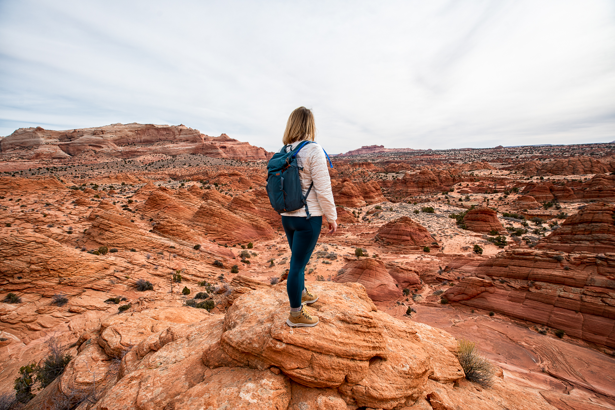
What is the Wave? The Wave is a Navajo Sandstone formation that is located near the Utah/Arizona border in an area known as Northern Coyote Buttes which is part of the Vermilion Cliffs National Monument.
If you are thinking, “This kinda looks familiar.” You’re right! A photograph of the Wave was one of the options as a desktop background for Windows 7. And I guess before there was Instagram and Pinterest people would wonder about that photo and start asking questions about where in the world it was taken.
The area is managed by the Bureau of Land Management (BLM), part of the United States Department of the Interior. The area is very sensitive, many of the rock formations including the Wave are fairly fragile and you have to be cautious of where you step, not just for your own safety but to preserve rock formations that took millions of years to form.
Because of the sensitive nature of this area, the BLM only issues permits for a maximum of 64 people to hike the North Coyote Buttes Wilderness Area a day.
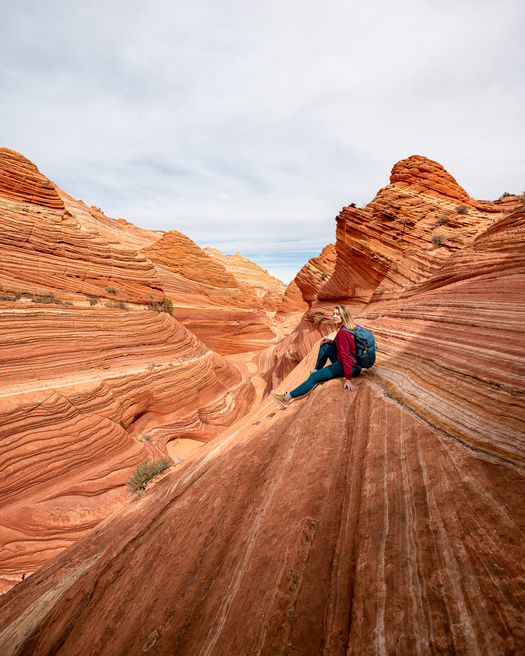
How do I get permits? Permits to the Northern Coyote Buttes area, where the Wave is located are issued lottery style where 48 people and/or 12 groups (whichever comes first) are awarded through the online lottery system and the other 16 people and/or 4 groups (whichever comes first) are awarded through the walk-in lottery, a separate process than this online lottery. The maximum group size is 6 people.
For the online lottery , permits are issued four months in advance by the BLM. On the website you will be required to watch a video about the area and what you are about to get yourself into. Fill out your information and pick your top 3 dates. The website also has a handy chart that lets you see how many people have requested each date so you can make your choices having a better idea of what your odds are.
The other 48 people and/or 12 group permits are issued in a in-person lottery at the Kanab Center Gymnasium, 20 N. 100 East in Kanab, Utah, the day before you wish to hike. You must be onsite to apply between 8:30AM and 9AM. The lottery takes place at 9AM and it’s literally a lotto style drawing with little balls in a bingo ball cage. Only one person per group can enter the drawing and if you win you must pay by cash or check. You can only win the walk-in lottery once every two weeks. Check out the BLM website as the drawing days change with season and based on holidays.
Important things to keep in mind about the permit lottery:
- Everyone, regardless of age, must be included in the permit. This includes infants that are not walking.
- You can apply for a maximum of 6 permits.
- You may select a max of 3 other people to act as alternate permit holders on your trip. Please enter a valid email address for each of the intended holders. They will receive an email and will need to validate within 72 hours.
- 48 people and/or 12 groups (whichever comes first) are awarded through the online lottery system and the other 16 people and/or 4 groups (whichever comes first) are awarded through the walk-in lottery
- You can only apply once per month on the website, if you submit more than once you forfeit your permit.
- Permits currently cost $9 each, and the fee to apply for a permit is $7.
- Your dog needs a permit to hike with you, also $7.
- Permits are for day use only, no overnights.
- Permits are non transferable, sorry can’t resell them!
- You cannot concurrently hold more than one permit for a permit area.
- The most applications are submitted for April-June and September-November.
- The least number of applications are submitted for January.
- There are no discounts and the America the Beautiful Annual Pass is not accepted here.
- If you decide to hire a guide, they do not count against your permit totals. They have their own commercial guide permits. The only way that this would not apply is if you contract a guide company to apply for permits for you. In that case your guide would take up one of your permits. Parties limited to one guide each.
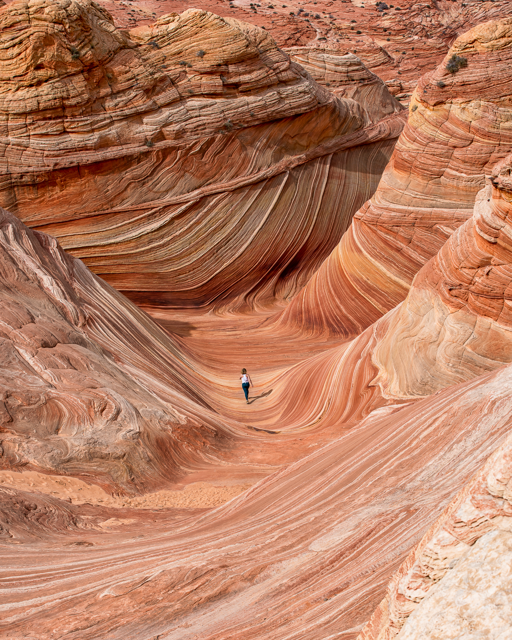
Are there any other options besides the lottery? Well, kinda. In very rare instances that there are cancellations or open dates, the BLM maintains a calendar that shows those openings and you could book your permit from this calendar. But this is a very sought after permit and the majority of people who get one are going to use it.
You could also try to have a local tour company secure permits at the in-person lottery for you but their chances are just as good as yours and they will end up taking up one of the permits if won.
The BLM is also supported by multiple volunteers, this includes checking permits and making sure people are respecting the area. I’m not sure what all the requirements are to become a volunteer but here’s the website to look for openings if you are interested: https://www.volunteer.gov/
Hypothetically, what if I just hike it without a permit? Hypothetically, of course. The area is patrolled regularly by rangers and volunteers who have a list of names of who has a permit for that day. You are also required to display a permit on your person and in your vehicle at the the trailhead parking lot. The permits are different colors for the online lottery and the in-person lottery, they are bright and can be spotted from quite a distance. You may be asked to present an ID that matches the permit so don’t leave your ID in your car.
If you were to be caught without a permit you can recieve a hefty fine of $1,000-$10,000 and possible jail time. The Wave is beautiful but not jail time beautiful.
Also, don’t be a jerk, the area is protected for a reason.
How do I get there and where should I stay? The nearest airport to the Wave is actual Las Vegas (LAS) and the nearest town is Kanab, UT. You are going to need transportation from Vegas to Kanab (which is about 3.5 hours away), renting a car is going to be your best bet for this.
In Kanab, there are multiple lodging options from Airbnb , to major hotel chains, to little privately owned bnb’s. I personally stayed at the La Quinta, it was quite nice! The town itself is pretty small, there’s a few dining options and a couple of grocery stores. But really you’re here for all the public lands. Just a short drive from Kanab is Zion National Park, Grand Staircase-Escalante National Monument, Bryce Canyon National Park, and a bunch of other smaller gems like Peek-a-boo Canyon. Don’t forget about these wonderful places while you’re here visiting the Wave.
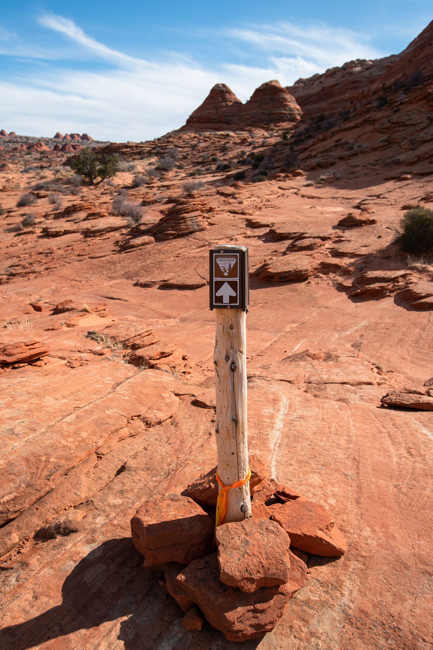
What’s the hike like? There are multiple trailheads to access the Northern Coyote Buttes area. Our tour guide went with the Wire Pass To Buckskin Gulch trailhead. This is about 45 minutes outside of Kanab and has a dirt road that runs for the last 8-ish miles of the drive. You will need an 4WD vehicle, preferably with high clearance. This road can get washed out and pretty messy so take note of the other trailhead options in case this is impassable. The BLM will provide you with a map.
If you were to go right from the trailhead to the Wave it’s about 3 miles. But there’s a lot to explore in the area and you practically have it to yourself! There are a few, rather unhelpful, directional signs that point in a general direction. Our guide has said that he has seen them turned around, so maybe don’t put a lot of faith in those. The BLM does provide a map with visual landmarks. The AllTrails app also came highly recommended from Claudia Frick who had hiked the Wave a couple weeks prior. TIP: Reach out to people on Instagram and ask them about their experiences, most people are super helpful and friendly!
I’ll be the first to admit that I’m not super outdoorsy. I’m in decent shape but I’m not hiking regularly and with full honesty, I’m not hitting my 10,000 steps a day with any consistency. There were a couple of spots where I found myself out of breath but for the most part, I felt way better about the hike than I thought I would. The pace was pretty casual and allowed for a lot of photos, sightseeing, and little stops. Probably stopped for about 2 hours at the actual Wave in the middle of the day. This gave plenty of time for photos and a quick bite for lunch.
The Wave is gorgeous at any time of day but for the best photos it is recommended that you get there at mid-day when the sun is highest. That way the entire formation is lit up without any shadows from the high walls. This is also when you will probably see the other permit holders during your trip through Northern Coyote Buttes.
I overheard one of the other guides mention that there’s a crow that will unzip your unattended bags to steal snacks, so watch out for him!
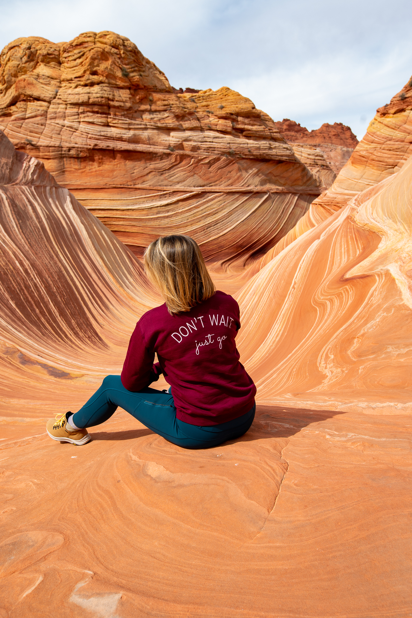
Get your own “Don’t Wait, Just Go” sweatshirt here .
Some other things to note: The only bathroom is at the trailhead and it’s a latrine. If you need to handle your business on the hike you will need to take it back home with you. There is also no garbage collection at the trailhead, so once again, pack in pack out! There is no water source at the trailhead or in the Northern Coyote Buttes area so you will need to bring all the water you need with you from Kanab or wherever you are staying.
When is the best time to go? This is a hard one. The most popular times are spring and fall because of the mild weather. The summer is going to be hot. This is a desert and there is little to no shade available on the hike. In the winter there is the chance for snow and of course colder weather. Starting in July to September is monsoon season so there could be a lot of rain and washed out roads. I went on February 28th and had the best weather, could not have asked for better.
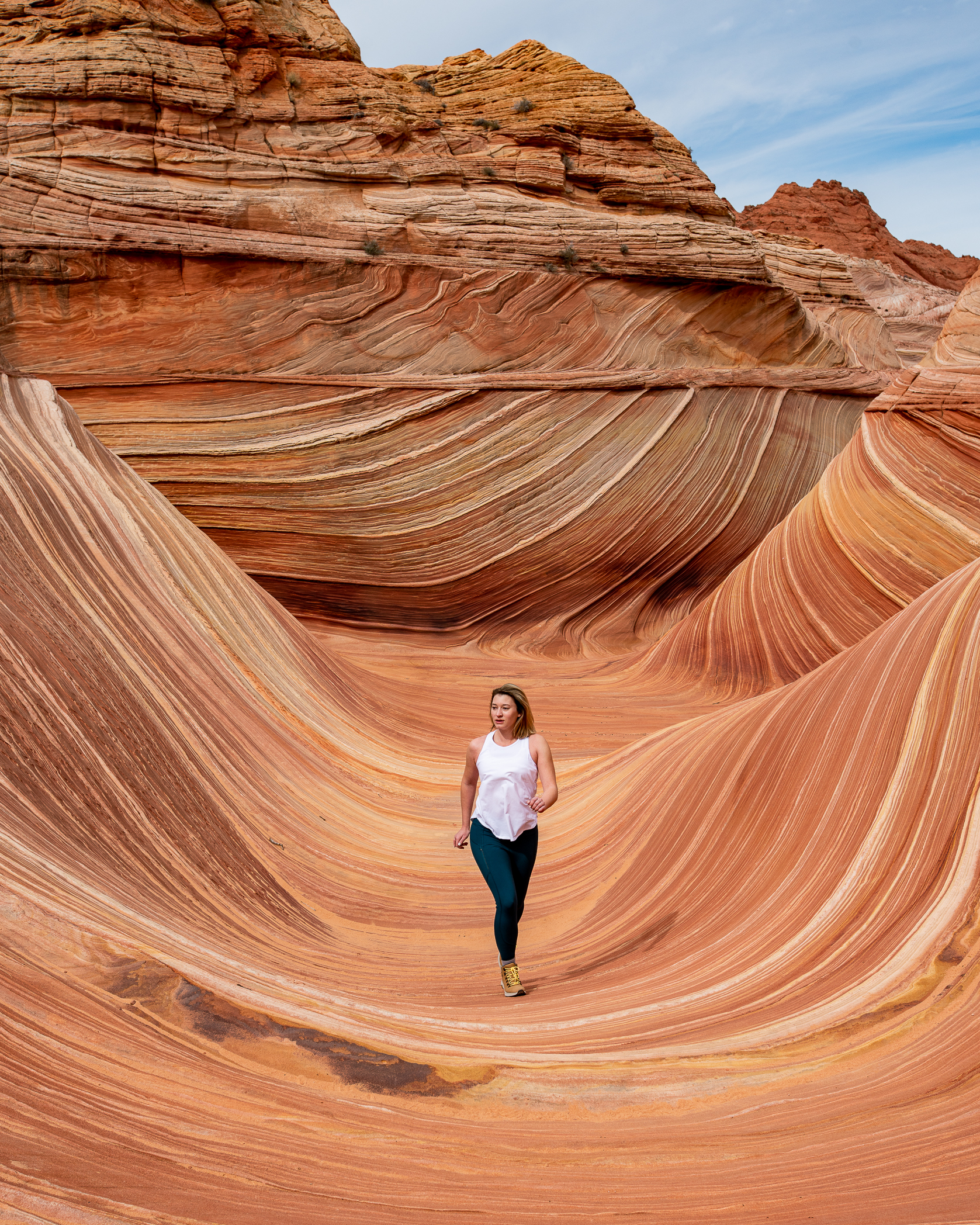
What should I bring? This will vary based on the time of year but here’s a solid list to get you started: Hiking boots/shoes Multiple layers of clothing depending on the weather Sunglasses Hat Backpack – doesn’t need to be huge Water – lots if it’s going to be a hot day Snacks Lunch Toilet paper and a plastic bag to take used TP back home with you Small first aid kit Sunscreen – this is must even in winter Camera – gotta get those shots, if you are planning on bringing a tripod make sure it has rubber feet to protect from damage Map and GPS, this can be the one from BLM or the AllTrails App or a GPS unit Headlight or flashlight , if you are planning to start before dawn or be out after dusk
Should I hire a guide? I sure as heck did! As previously stated: I’m not an experienced hiker, there is no marked trail, and this hike can be dangerous if you are unsure of what you are doing. Brent was my tour guide from Dreamland Safari Tours . The tour had door to door service and I was picked up from my hotel in Kanab in a robust AWD vehicle and taken directly to the trailhead. Here’s why I loved having a tour guide:
- Didn’t have to do any navigating, just followed Brent and enjoyed the views
- The tour company provided water, snacks, and a sandwich for lunch
- If I had any questions, they were answered by Brent
- Brent was able to point out things that I would have never found on my own, like dinosaur tracks
- I was kept on schedule so that I made it to the Wave in prime photo time
- Wanted to get a group photo? Brent was right there to lend a hand
- If for some reason the main trailhead was inaccessible, Brent had multiple backup plans
- If someone got hurt or needed medical assistance, Brent was carrying a SOS beacon/satellite phone
- Brent was also there to educate on how to treat the land with respect and hike without doing any damage
How much did all of this cost? Please note that fees increased in 2021. Airplane ticket from Austin to Vegas: $312 (this was pretty expensive for a flight to Vegas) Hotel in Vegas, 1 night: $102 Rental SUV for 4 days: $213, not including gas Hotel in Kanab, 3 nights: $252 Tour Guide (per person): $185 + tip Permit fee: $7 Lottery fee: $5 Total: $1076
Some things to note: This obviously doesn’t include meals and a few of these items like the car rental were split by the group. This also doesn’t include the cost of the items I bought to hike the Wave, like I said I’m a novice and didn’t really own any hiking gear up until now.
Was it worth it? Heck yes! Totally recommend adding this to your travel dreams list.
Resources My Arizona Pinterest Board with all my Wave research My Hiking Gear Pinterest Board BLM website with info on Coyote Buttes Coyote Buttes North lottery website Dreamland Safari Tours
Disclosure: This post may contain affiliate links, which means I may receive a commission if you click a link and purchase something that I have recommended. While clicking these links won’t cost you any extra money, they will help me keep this site up and running as well as keep me traveling!
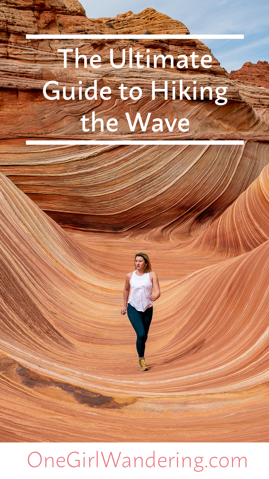
Turn your travel photos into cherished memories with our Lightroom Presets!

Ultimate Guide to Hiking the Wave in 2024
There may be some affiliate links on this page, which means when you click we get a small percentage of the purchase at no extra cost to you. This allows us to keep this page running. Enjoy!
Last Updated on December 4, 2023 by Sarah Puckett
Hiking the Wave has been on our bucket list for years! One of the most coveted hikes on earth, only a few people per day are able to visit this iconic sandstone formation in Vermilion Cliffs National Monument. What makes this place unique are the smooth striations in the Navajo Sandstone, creating a smooth, curvy, and otherworldly landscape that resembles the waves of the ocean.
We applied over 25 times to the Coyote Buttes North permit lottery before finally winning a permit to hike the Wave in January 2023. This is definitely one of the most difficult-to-plan adventures we’ve had to date, so I wrote this blog post to tell you everything you need to know about the permit process and the hike for the Wave in Coyote Buttes North.
Disclaimer: Dreamland Safari hosted us on a guided hike to the Wave in exchange for social media content and this blog post. We obtained our permits on our own via the advanced online lottery. All opinions and recommendations are our own, and we hope that they make your planning easier and your adventure even better!

Table of Contents
Where is the Wave hike?
A common misconception about the Wave is that it is located in Utah. This is not technically true! The Wave formation is actually just a mile or so over the Utah/Arizona state line, on the Arizona side.
On the hike to the Wave, you’ll start your trek in Utah and end in Arizona!
Most people who hike to the Wave stay in Kanab, Utah as their base. It is the closest town to the trailhead (one hour from downtown to the Wire Pass Trailhead on House Rock Valley Road). Page, Arizona is another popular base for hiking the Wave and is also only slightly over an hour’s drive from town to the trailhead. We’ll talk more about where to stay when hiking the Wave below!
What is the Grand Staircase anyway?
The Wave is located in the Vermillion Cliffs National Monument in Arizona, which starts on the Arizona side of the border with Utah. Its neighbor to the north in Utah is Grand Staircase – Escalante National Monument. Both National Monuments protect what is known as the Grand Staircase, which refers to the expanse of land between Bryce Canyon National Park and the Grand Canyon. Between the two, layers of the earth rise, like stairsteps, each taller than the last, leading the way up to Bryce. In Bryce Canyon National Park, you can actually see these “steps” descend in the distance as they gradually, step-by-step, descend to the Grand Canyon.

What is the difference between the Coyote Buttes North and Coyote Buttes South?
Within the Vermillion Cliffs National Monument, there are two commonly-confused permit areas known as Coyote Buttes North and Coyote Buttes South. Both of these areas are protected and can only be visited by those lucky enough to hold a permit! We’ll explain the permit process in depth below but first wanted to make sure to make the distinction between these two areas. Coyote Buttes North is home to the Wave as well as a half-dozen or so other noteworthy landmarks. Coyote Buttes South is an area just south (obviously) of Coyote Buttes North. It is best known for its sandstone TeePees (basically conical petrified sand dunes) and strange rock formations that look like they came from a Dr. Seuss book.
The permit to visit Coyote Buttes South is MUCH easier to obtain than the permit for Coyote Buttes North. We consider it a great option if you don’t win a permit to Coyote Buttes North.

That said, even though the two areas are only a few miles apart as the crow flies, you CANNOT visit both on one permit. Your permit to Coyote Buttes North does not allow you to visit Coyote Buttes South or vice versa. In other words, you can’t get a permit to Coyote Buttes South and then hike into Coyote Buttes North. That is illegal and BLM volunteers and patrollers will cite you.
We’ll get into more details on the penalties for entering Coyote Buttes North without a permit a bit later in this post.

How does the Permit Lottery Process for Hiking the Wave Work?
In order to hike to the Wave, all visitors MUST have a permit for Coyote Buttes North, issued by the Bureau of Land Management.
There are two ways of getting a Permit for the Wave and Coyote Buttes North: the Advanced Lottery and the Daily Lottery.
Both lotteries are held online, but you must be using a mobile device within a geocache area (basically around Kanab and Page – see map below) for the Daily Lottery. Before March 15, 2022, the Daily Lottery was held in person in the Kanab Center gymnasium.

We attended the in-person lottery multiple times over a few years but never won. That said, it was always an exciting event, with lots of applause, tears, and general hype. The vibes were immaculate.
In any case, moving the in-person Daily Lottery to a virtual-only event does make the logistics of obtaining a Daily Lottery permit easier, which is good news for travelers who want to spend more time adventuring and less time in a community gym.

The Advanced Lottery for The Wave (Coyote Buttes North)
We eventually won our permits to the Wave via the Advanced Lottery . You can apply for the advanced lottery from anywhere in the world. All you need is the internet and a recreation.gov account (free).
You should apply for the Coyote Buttes North advanced lottery four months in advance of the month you want to hike the Wave. For example, since we hiked to the Wave in January, we applied to the Coyote Buttes North permit lottery in September of the previous year.
When you apply, you may select up to three dates within that calendar month. We recommend choosing the maximum number of dates to increase your chances of winning!
Recreation.gov will email out the lottery results on the 1st of the month following the month you entered. For example, we applied in September and received an email on October 1 notifying us that we had won for January 17. Yay!
The Bureau of Land Management issues 48 permits, or 12 groups (whichever comes first) via the Advanced Lottery for Coyote Buttes North.
Coyote Buttes North Advanced Lottery Schedule

The Daily Lottery for The Wave (Coyote Buttes North)
The Daily Lottery for the Wave is now held online via a geo-fenced system hosted on recreation.gov. Prior to March 2022, the Daily Lottery was held in person at the Kanab Center for people wishing to hike the following day. Now, the online Daily Lottery opens TWO days before you want to hike. For example, if you want to hike on a Wednesday, you will apply for the lottery on Monday.
The application for the Daily Lottery for Coyote Buttes North costs $9.You should enter the lottery between 6 am and 6 pm two days before the day you want to hike the Wave.
Winners will be announced at 7:15 pm on the same day. The Daily Lottery for Coyote Buttes North issues permits to 4 groups or 16 visitors (whichever comes first).
NOTE: You must be within the geofenced area when you apply for the lottery, but you do not need to be within the geofenced area when winners are announced.
If you win the Daily Lottery for Coyote Buttes North, you have until 8 am the next morning to accept the permits. Following the example above, where you apply on Monday to hike to the Wave on Wednesday, you will accept your permit before 8 am on Tuesday.
You also need to attend a mandatory safety briefing at 8:30 am in Kanab or Page on this day. During this safety briefing, you will pay $7 per person or dog to pick up your permit – the magical pink tag that makes you an official permit holder for Coyote Buttes North!
Be on time to this mandatory briefing! We have heard stories of the BLM withholding permits from late arrivals!

How many permits are granted per day for Coyote Buttes North?
64 people are awarded permits every day for Coyote Buttes North in total, including both the Daily and Advanced Lotteries. This means a maximum of 64 visitors hike to the Wave every day. Usually, this number is much lower since the lottery usually reaches the cap on groups before it reaches the cap on individuals. In other words, for 64 people to visit the Wave on any given day, each group needs to have 4 people in it. Most groups have fewer than four people in them, so it’s unlikely you’ll be hiking with 63 new friends.

How can I enhance my chances of getting a permit?
- Apply every month in the Advanced Lottery for Coyote Buttes North
- Choose 3 days (the maximum) as options for your Advanced Lottery Permit
- If you are in Kanab or Page areas, apply to the Daily Lottery every single day
- If you did not succeed in obtaining an Advanced Lottery Permit and are not physically within the geocache area for the Daily Lottery, you can book a conditional Wave tour through Dreamland Safari . Dreamland will apply to the Daily Lottery on your behalf. If you win a permit, they will take you on a tour to the Wave and Coyote Buttes North. If you do not win a permit for Coyote Buttes North, they will apply to the lottery for Coyote Buttes South. If you do not win either lottery, they will take you on a tour of one of the many other wonderful landscapes in the area (like White Pocket !).
How do I obtain my permit after winning the Wave lottery?
When you win the Advanced Lottery for Coyote Buttes North, the Bureau of Land Management will mail you your permits via US Postal Service mail about 4-6 weeks after you win. If you don’t receive your permit in the mail, call the Bureau of Land Management and let them know. Ours got lost in the mail and we almost didn’t get to hike to the Wave because of it! Thankfully we were able to have a replacement permit issued for us since the electronic reservation system had a record of issuing our permits.
If you win the Daily Lottery for Coyote Buttes North, you will obtain and pay for your permit at the mandatory briefing the day before your hike.

Are there other things to do instead if I don’t get a permit for hiking the Wave?
If you do not get a permit for the Wave and Coyote Buttes North, there is still plenty to do in the Kanab area. Some of our favorite alternatives to hiking the Wave are:
- Getting a permit for Coyote Buttes South instead and exploring the unique formations there.
- Visiting White Pocket , one of the most otherworldly landscapes we’ve ever seen!
- Driving the dirt road to Paria Townsite, one of the most colorful and beautiful places on earth.
- Visiting nearby Bryce Canyon and Zion National Parks.
Can I still hike the Wave if I don’t have a permit?
You absolutely CANNOT hike to the Wave if you do not have a permit for Coyote Buttes North. There are no exceptions to this rule. You must have a permit to hike to the wave, and you must hike on the day of your permit. You can not reschedule or take a rain check for your permit to Coyote Buttes North.
The only individuals who can be in the Coyotes Buttes North permit area without a permit from the Bureau of Land Management (BLM) are guides and BLM volunteers/patrollers assigned to monitor the area for trespassers.

What is the penalty for hiking the Wave without a permit?
If you are caught hiking in the Coyote Buttes North permit area or the Wave with a permit from the BLM, you risk a fine of between $1,000 and $10,000 per person, plus up to one year in jail. You will also be banned for life from applying for a permit for Coyote Buttes North in the future. It is simply not worth it.
Plus, by hiking to the Wave without a permit, you are not only breaking the law, but you are also exposing this fragile environment to more people than it can sustain. The permit system exists to protect this delicate formation.
How to get to the Wave Trailhead at Wire Pass
The trailhead for the Wave is located on a dirt and gravel road called House Rock Valley Road off of US Route 89 midway between Kanab, Utah, and Page, Arizona. Nine miles after turning onto House Rock Valley Road, you will arrive at the Wire Pass Trailhead, which is also the trailhead for the Wave. You’ll see the dirt parking area on your right when coming from US Route 89. There are drop toilets at the trailhead. We recommend packing all of your trash out with you.
House Rock Valley Road Conditions and Vehicle Requirements
In dry weather, you do not need a 4×4 or 4-wheel drive to get to the Wire Pass Trailhead. However, if it’s been wet, the road gets incredibly muddy and sloppy. The thick clay devours 2-wheel drive or all-wheel drive vehicles that attempt the drive when the ground is wet. The day we went was one such day, and the AWD sedan in front of us got stuck in the mud. Tim had to push them out!
Some blogs or websites will tell you that House Rock Valley Road is impassable when wet, but this is not strictly true.
We don’t recommend self-driving House Rock Valley Road unless you have a 4×4 vehicle and plenty of offroading experience. But, if you have a Jeep-like vehicle with high clearance and four-wheel-drive, plus the experience to match, you should be able to navigate the road in most conditions. The only time the road is truly impassable by any vehicle is when Buckskin Gulch is flooding, typically during the summer rainy season.
If you don’t have a suitable vehicle and off-road driving skills, you can still get to the Wave when the road is wet by hiring a guide (we went with Dreamland Safari ) who will provide transportation. In general, if you are at all worried about road conditions getting to and from the Wire Pass Trailhead for the Wave, you should arrange to visit with a tour guide.

Hiking The Wave Step-by-Step
Okay, so you got your permit for Coyote Buttes North! Woohoo! Now, you need to make sure you are prepared for the hike! Many people get so excited by the prospect of seeing the Wave that they forget you must hike a minimum of 6 miles round trip across completely sun-exposed desert terrain on a mostly unmarked trail to see it! This section of our blog post aims to equip you with everything you need to know about what to expect on the day of your hike.
We’ll start by covering some frequently asked questions about the hike, and then go into a step-by-step description of the trail.
How difficult is the hike to the Wave?
The hike to the Wave is considered moderately difficult. It’s not particularly strenuous or steep, but you can certainly succumb to the dangers of desert hiking and wilderness wayfinding in Coyote Buttes North. That said, the trail itself is not very hard.
The greatest difficulties most hikers will experience will on the hike to the Wave will be:
- Dry desert weather (bring at least 3 liters of water per person!)
- Getting lost (download a map on All Trails in advance, and follow the map the BLM will give you with your permit!)
- The altitude (the Wave is at over 5000 feet of elevation so some hikers experience altitude sickness symptoms like shortness of breath and fatigue).

How long is the hike to the Wave?
The hike to the Wave formation within Coyote Buttes North is about 6 miles round trip. There are several unique landmarks and features to see in the Coyote Buttes North permit area, however, so if you plan on seeing all of the spots, expect to hike closer to 10 miles.
Actual hiking time is about 3 hours to the Wave and back to the Wire Pass Trailhead, but you should plan for your trip to the Wave to take all day, taking into account the road and how much time you’ll want to spend exploring!
Can I see the Wave from outside the permit-only area?
You cannot see the Wave from outside of the permit-only area. The permit area starts about 2 miles from the Wave formation and is obstructed by buttes. Binoculars won’t help, and drones are not permitted. The only way to see the Wave outside of satellite maps and photos is by getting a permit and going! The Wave itself is a very small area – you can’t see it until you are well and truly in it!
Detailed Route Information for Hiking the Wave
The detailed route information for the Wave hike we share below is intended for informational purposes only. Please use the map provided by the BLM with your Coyote Buttes North permit for wayfinding during your hike. Additionally, we recommend downloading an offline map of the Wave hike on AllTrails.
Park at the Wire Pass Trailhead
Be sure to display your pink parking permit in your front window. Attach the portion of the permit with a hole punch and wire to your bag in a secure and visible manner. Sign in for your hike in the trail log by the drop toilets. Remember to sign out when you return later! This is how rangers know whether you are missing and need help.

1. Cross House Rock Valley Road
You’ll see a narrow river bed, which may be dry or flowing. This is Coyote Wash. You should follow the wash for about a half mile. After a half mile, you will see a well-worn path on your right that leads away from the wash.

2. Follow the path uphill
At the top of the hill, you will reach a sandy flat. Look for a small ridge in the sandstone structure ahead of you. This is the “small saddle” referenced in the map the BLM will give you with your permit. You need to cross the ridge of the saddle. Many visitors get lost here, so pay attention!

3. At the top of the saddle
Be sure to orient yourself to the landmarks around Point 3 on the below map. This is a common place to become disoriented on your return hike.

4. Aim for the Twin Buttes
From the saddle, you will hike south. Keep the sandstone ridge on your right and follow it towards the Twin Buttes.

5. Cross the Twin Buttes on the right-hand (uphill) side
Look for the dark crevice indicated on the map you receive from the BLM in step 5. The Wave is located below this crevice, so aim for this direction.

6. Cross two small sand dunes
When you reach the point between the two sand dunes, continue south across Sand Cove Wash. Climb the sandy hill. This part is a little bit steep and one of the more challenging parts of the Wave hike. Hiking on sand is literally like taking one step back for every two steps forward. Don’t fret – you are getting close! From the top of the sand hill, follow the short wash. You made it! You are at the Wave!

Return Hike
After you have had your fill of exploring and photographing the Wave and all the areas around it, you will return back to the Wire Pass Trailhead the same way you came. The landscape looks different coming back, though, so take note of the photos provided in your BLM map to help you find your way.

7. Return to the sandy hill
Leaving the Wave, head to the top of the sandy hill. Look for the sand dunes you cross on your way in and walk towards them.

8. Look for the Twin Buttes
Hike towards the Twin Buttes and cross on the uphill side.
9. Hike north to the small saddle
Paying attention for the landmarks you noted on your hike in, hike north to the small saddle.

10. Cross the saddle
When you cross the small saddle, it should not be very steep. If you arrive to the top of the saddle, and the descent looks very steep, you are too far south on the saddle. Backtrack north to the small saddle.
11. Return to the Wire Pass Trailhead parking lot
Follow the trail back to the wash, and then follow the wash back towards the road. Cross House Rock Valley Road and return to the parking lot! Don’t forget to sign out on the registration log!

What to Wear/Bring When Hiking the Wave
Here’s a list of what you should bring with you or wear on your hike to the Wave. The links in this section are affiliate links which allow us to earn a small commission at no extra cost to you. We greatly appreciate your support!
- Hiking boots. I love my Columbia Newton Ridge waterproof boots. Tim swears by his Foxellis .
- Dress for the weather and wear layers. The day we went in January was snowy and cold. I wore two pairs of leggings , a tank top, a thermal top layer, and a fleece all under my down coat.
- Year-round but especially in summer, make sure to have sun protection. Wear a wide-brimmed hat and use eco-friendly sunscreen like SunBum .
- Your paper map from the BLM and a digital map on your phone (we like AllTrails).
- Walking poles/sticks (with rubber tips ! Metal tips destroy the sandstone)
- Water, either in a hiking reservoir or a bottle in your pack. Aim for at LEAST three liters of water.
- Snacks and sandwiches. We always bring Clif bars on hikes.
- Electrolyte powder to prevent and/or manage dehydration.
- First aid kit . Hopefully, you won’t need it, but if you do need it you’ll be glad you have it.
- Camera with a wide lens. Tip: If you don’t have or want to buy a camera, the 0.5 setting on your phone camera can help you get wider photos at the Wave! More photography tips for the Wave are included a bit further in this blog post!

Closest Airports to the Wave
Page (PGA) – This small municipal airport is serviced solely by Contour Airlines for commercial flights. Rental car availability may be limited, so we recommend confirming rental car options before booking a flight to this tiny airport.
St. George (SGU) – 1.5 hours to Kanab. St. George is a good option, though routes may be limited and prices relatively high. But, this is the closest option to Kanab, and St. George is a large city where you shouldn’t have issues getting a rental car.
Las Vegas (LAS) – 3 hours to Kanab. We generally recommend flying to Las Vegas when visiting the Wave. You’ll have the best route options since it’s a major airport, and flights in and out of Las Vegas tend to be relatively less expensive than other nearby airports.
Phoenix (PHX) – 4.5 hours to Page. This is a good option for international travelers coming to the southwest. Phoenix is a major city and thus a hub for air travel.
Photography tips for Hiking the Wave
Orientation to the wave’s shape.
To help you orient yourself to the Wave and plan out your photography objectives prior to your hike in Coyote Buttes North, we’ve put together a compilation of our photographs alongside corresponding satellite maps from Google Earth of the Wave formation.
Photo 1: The “Classic” Wave View:

Photo 2: To the right when you first arrive

Photo 3: Facing the opposite direction from Photo 2

Lighting and Shadows
In general, the best time of the day to photograph the main view of the Wave formation is going to be early in the morning or late in the afternoon when the sun is low enough in the sky to not cast a shadow on one of the Wave walls.
We were lucky to have overcast skies the day we visited the Wave, so we didn’t have to worry about shadows too much.
Reflections and Water Pools
There are several locations around the Wave where pools of water form after recent rain or snow. Look for an oblong reflecting pool of water as you enter the Wave formation. Here is one of our photos in this location as an example, along with a helpful orientation map! Notice the shade in the satellite image. This is where the water pool will be if there’s been recent rain or snow melt.

Photographing the Wave in Rain or Snow
When the sandstone of the Wave is damp, you will see more colors in the striations. For example, lines of yellows and greens will be visible on the rock. In general, the colors will be deeper when the rock is wet.

With a light dusting of snow, you will still see the striations of the Wave peeking through lines of white. In heavy snow, however, it will look like a blanket has covered the entire formation! This is what it looked like when we arrived during heavy falling snow. The Wave was beautiful in its way but also lacked the dramatically smooth lines that are so characteristic of this iconic location.

Tip: If the Wave is fully blanketed in the snow when you arrive, wait out the weather until the afternoon if you can. Once the sun comes, it will quickly melt the snow and you might get to see the striations in the rock!
Because of how snowy it was when we arrived at the Wave, our guide offered to let us stay in the formation longer after all of the other tour groups had left, and luckily this gave us enough time for most of the snow to melt. We were able to capture some amazing photos of a half-snowy Wave, something most people do not get to see!

FAQs for Hiking the Wave
Are dogs allowed to hike to the wave.
Yes, dogs are allowed to hike to the Wave. Just be sure to include them on your permit!
Is a guide required when hiking the Wave?
No, a guide is not required to hike to the Wave. However, you may want one anyway. Here are some reasons why:
- Going to the Wave with a guide gives you the best chances of getting to the trailhead when the road is otherwise impassable
- A guide can show you other locations in Coyote Buttes North. Note: we did not get to see any of the other formations because of the snow and ice conditions.
- A guide can assist in the permit lottery process, for example by applying to the daily lottery on your behalf while you’re traveling into the area
- Hiking to the Wave with a guide is safer since you won’t get lost and guides have satellite phones, extra water, and snacks to keep everyone safe
We recommend booking a tour with Dreamland Safari tours if you want to hike to the Wave. If you already have a permit, you can book the Wave tour. If you don’t already have a permit, you can book the Wave Conditional Tour. Dreamland will apply to the Coyote Buttes North daily lottery on your behalf 2 days before the date of your tour. If they win a permit on your behalf, one of their experienced guides will take you on a tour of the Wave. If they do not win a permit on your behalf, they will apply to the Coyote Buttes South lottery. Then, if they do not win a permit to Coyote Buttes South, they will take you to one of the other amazing non-permit areas in the area (for example, White Pocket ).

What is the geology of the Wave? How was the Wave formed?
The Wave, at an elevation of 5,225 feet above sea level, is made from Navajo Sandstone and began to form over 190 million years ago. You can think of the Wave as a petrified sand dune, where the sand hardened and calcified over time in vertical and horizontal striations. Thanks to the power of wind and water, the sandstone gradually eroded into the smooth and curvy shape that we see today.

Final Thoughts on Hiking the Wave
Even with the erratic weather during our hike to the Wave, getting to see this incredible place for ourselves exceeded our wildest expectations! If you’ve applied for a permit to Coyote Buttes North before and didn’t win, keep trying. It will be worth it when you finally get to go!

Similar Posts

Ultimate North Dakota Road Trip Itinerary

35+ Unique Things to Do in Sedona, Arizona

Ultimate Guide to Sunset at Dead Horse Point State Park

Best Volcanoes to Visit in Java, Indonesia

Arches National Park One Day Itinerary

Hermit Trail to Santa Maria Spring – Grand Canyon National Park’s Most Underrated South Rim Hike
This is the most thorough post about the wave ever! Thank you, Sarah 🧡🧡🧡
Thanks Tim!
What camera did you all use?
Hey Laura! We shoot with a Sony a7III. We have all of our camera gear linked in an Amazon list here if you want to check it out! https://www.amazon.com/shop/organized_adventurer/list/223PB43KXAVEW?tag=onamzsarahpuc-20&ref_=aip_sf_list_spv_ofs_mixed_d
Leave a Reply Cancel reply
Your email address will not be published. Required fields are marked *
Save my name, email, and website in this browser for the next time I comment.
This site uses Akismet to reduce spam. Learn how your comment data is processed .

(435) 414-9793

[email protected]
The Wave (coyote buttes north)
The Wave, officially referred to as Coyote Buttes North, is an iconic jewel of southern Utah. The lack of access to real ocean waves in this desert climate is compensated for here as the striking geological sandstone formations create rock waves. If you are lucky enough to obtain a permit, the hike can be rugged and challenging but we promise it will exceed your expectations!

additional details
Pricing 7-8 hour tours , ***all tours are subject to 15% taxes and fees***.
***With current unpredictable inflation of gas prices, ALL PRIVATE TOURS WILL BE SUBJECT TO AN ADDITIONAL GAS SURCHARGE OF THE DIFFERENCE OF THE CURRENT PRICE PER GALLON OVER $2.75/GAL. Pricing was originally made when gas was $2.50/gal, we hope there is another drop before we have to permanently change our prices. Thank you for understanding!
Select a Tour Duration, Location and Number of People below to start booking your tour.
Email Address
Your Phone Number
Number Of People In Group
Tour Type Tour Type 2-3 Hour Tour Half-Day Tour Full-Day Tour Combo
Tour Requested (2-3 Hours) Tour Requested (2-3 Hours) No Preference Peek-a-Boo Slot Canyon The Great Chamber Candy Corn Toadstools Inchworm Arch Pinnacles/TV Tours The White Wave Rosie Canyon Petroglyphs Moccasin Dinosaur Tracks South Fork Pictographs
Tour Requested (Half-Day) Tour Requested (Half-Day) No Preference The Huntress - Canyoneering/Rappelling Kanab Creek Overlook - Canyoneering/Rappelling Advanced
Tour Requested (Full-Day) Tour Requested (Full-Day) No Preference Rock Canyon White Pocket The Wave - Need Permit To Tour Wire Pass / Buckskin Gulch Coyote Butte South - Need Permit To Tour
Combo Combo No Preference Best of Kanab / Choice of 3+(K) Walk With the Ancients/Choice of 4+(K)
Rosie Canyon Petroglyphs
Drive Distance:
- About 40 minutes from Kanab including 2 miles of deep sand
- 10-15 minutes from the Coral Pink Sand Dunes
- 10 minutes to the Moccasin Mountain Dinosaur tracks turn off
Hike Distance:
- Less than 1 mile round trip
- The hike is easy except at the end there is a little scramble to get up to the petroglyphs
- We rank the overall hike a 2/10 difficulty, except that one section of 50 feet we’d rate about a 4
Recommended Items:
- We provide plenty of water, but always encourage guests to bring extra
- Sun screen
- Closed-toe shoes
- Hat and sun glasses
- Coat (October-March)
- Warm hat (October-March)
- Gloves (October-March
- Boots/thick socks (October-March)
Why We Love This Site:
This panel is one of our absolute favorites! We love to show people the amazing rock art from centuries past in Rosie Canyon. This particular spot is in a really pretty setting in a tiny box canyon. The short hike is in a wash with wonderful scenery in every direction.
Best Combinations for this site:
- Peekaboo Slot Canyon
- South Fork Pictographs
Moccasin Mountain Dinosaur Tracks
- Of the options in the “Best of Kanab Southwest Tour”, Rosie Canyon is a must!
Private Tour Pricing: All tours are subject to 8.1% state sales tax, and 3% BLM land usage fee(subject to change)
Single Site
2 Site Combos
5+ Sites, Best of Kanab Tours NE & SW
$135 ($67.50/per)
$225 ($112.50/per)
$400 ($200/per)
$180 ($60/per)
$290 ($96.67/per)
$500 ($166.67/per)
$180 ($45/per)
$290 ($72.50/per)
$500 ($125/per)
$225 ($45/per)
$290 ($58/per)
$500 ($100/per)
$225 ($37.50/per)
$290 ($48.33/per)
$500 ($83.33/per)
White Pocket
Please Call
*For groups of 7 or more we will likely need another vehicle and guide. Please contact us for pricing. Thank you!
Phone: 435-899-0697 or 801-631-3500
- about 40 minutes from Kanab
- The last two miles are on a deep sandy road
- Near- Rosy Canyon turn off, Coral Pink Sand Dunes
- About ½ mile round trip
- This hike is easy. We rank it a 1/10 difficulty.
- We will drive up to within 20 yards of the first tracks.
Recommended Items:
- Closed-toe shoes
- Shade hat and sunglasses
- Gloves (October-March)
This is one of the easier places to hike and see evidence of ancient life. The tracks lie in a beautiful sandstone wash where you will feel remote and quiet. Our vote is that this is one of nature’s perfect yoga/meditation spots! We frequently hear, “I can’t believe I’m walking in the very place the dinosaurs walked! This is so cool!”. Although it is not technical at all, it is a great experience to marvel at the history of the rocks we walk on here!
- Add on to Peekaboo Slot Canyon
- Easy to combine with the Rosie Canyon Petroglyphs
- A fun complement to the South Fork Pictographs
- For the “Best of Kanab Southwest Tour”, the Dinosaur Tracks are a great option!
(7 Hours Round Trip)
- About 70 miles (26 miles of dirt and sandy roads)
- 2 hours 15 minute drive from Kanab
- Near Coyote Buttes South
- Usually 2-3 hours
- The hike is as easy as you’d like it to be, but it is full exposure to the sun
- We rank the overall hike a 3/10 difficulty, unless you want to take a back route, then it’s a 6.
White Pocket is a unique landscape where we wander around in the 1.5 square miles of white “brain rock”, and take in the amazing red, yellow, and orange swirls erupting out of the otherwise uniform out of this worldly formation. White Pocket offers a variety of formations and colors. It is our most popular 7-8 hour tour. We love being out there because it feels like a brief trip to another planet!
- Peekaboo Slot Canyon (Peekaboo morning- lunch break in Kanab – head out to White Pocket for sunset is our most popular full day combo)
- Coyote Buttes South (permit required)
Private Tour Pricing: All tours are subject to 8.1% state sales tax, and 3% BLM land usage fees
4+ Sites, Best of Kanab Tours NE & SW

Adventure of a Lifetime
For the lucky few who get one of the limited daily permits, it will be an unforgettable experience!
Self Guided Permits
Information about Self Guided Daily Trips including how to get a Permit, Maps and Information
Hire a Guide
Information about Hiring a Guide. How to get a Permit, Maps and Information
Hike Checklist
Tips and Tricks for a successful hike. This should be the last thing you read before heading out.
Return to the Canyons! Antelope Canyon Tours Book Now!
Antelope canyon / lower antelope canyon / antelope canyon boat, antelopecanyon.az is your one stop booking site for antelope canyon, featured content.
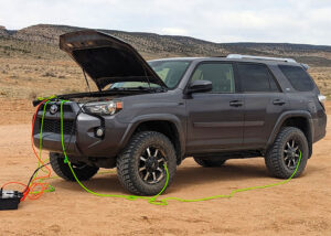
Offroading to the Wave
Houserock Valley Road Offroading to the Wave AZ Be aware that depending on the weather and road conditions, just getting to Wave Trailhead can be
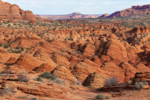
So you didnt get a permit for the Wave. Now what?
So you didn’t get a permit for The Wave. Now what? ***WARNING: we do not, we repeat NOT, in any way shape or form, no
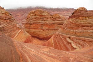
What is the Wave?
What is the Wave? Michaelangelo took 2 years to sculpt the statue of David. Leonardo da Vinci spent 4 years painting the Mona Lisa. Mozart
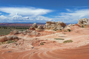
Alternative areas around the Wave
Alternative areas that may remain accessible to vehicular travel and dont require a permit The diversity and options that can be found in this part
Join Our Facebook Group
The wave image & video gallery, weather, lighting and angles can create wonderful effects.

Area Attractions and Tours
Horseshoe bend, antelope canyon, antelope canyon boat tours, copyright thewaveaz.com 2023.
- PERMIT REQUIRED
The Wave Tour
Discover the iconic beauty that awaits in the heart of the northern Arizona desert
Quick Details
- User Ages: 5 Years & Up
- Hour Glass Duration: 8 Hours
- Users Max Group Size: Up to 6 People , For larger groups, please call us to book!
- Info Requirement: BLM Permit
- Check Bubble Activity: Hiking Tours
You’ll be sent a waiver to sign along with your booking confirmation.
Prepare to be Mesmerized as You Tour The Wave in Coyote Buttes, Arizona
Visitors are limited to protect this beautiful land. You MUST obtain a BLM permit before we can take you on this tour.
Now, let’s talk about The Wave. It’s a mind-blowing sandstone wonder right on the Arizona-Utah border . We’re here to hook you up with a ride to the trailhead and a savvy guide to help you conquer the desert.
Once you’re there, it’s all about free exploration . Get lost in the smooth curves and rolling formations. Absorb the dusty reds and brilliant blue skies – it’s pure magic. Plus, our guide is your go-to for history, plants, geology and wildlife info. Let’s make this hike unforgettable!
- Chevron down What to Bring
- Make sure to bring plenty of water, a lunch, sunglasses and a hat, and good hiking/walking shoes
- North Coyotes Buttes Permit!
- Chevron down Inclusions
- 4 WD transport to and from The Wave trailhead
- A friendly & knowledgeable guide
- 8 miles of guided hiking
NOT INCLUDED
- North Coyote Buttes visitor permit
- Lunch (Please bring your own, you’re welcome to store them in our cooler.)
- Gratuity for your guide
- Chevron down Important Info
- We provide 4WD transport to and from The Wave trailhead.
- You’ll receive 8 miles of guided hiking to The Wave and the surrounding areas of North Coyote Buttes.
- You’ll need to sign a hiking waiver after booking this tour. Click here to view the waiver.
- You need a permit to take this tour . Click here to find out how to apply for one.
- This is a challenging and strenuous tour. It’s best suited to experienced hikers with a high level of fitness and health. 7 to 12 miles round trip.
- Chevron down Add-on to Wire Pass Slot Canyon
Fill your day with as much adventure and natural beauty as possible by adding on a visit to Wire Pass Slot Canyon. For an additional $150 we’ll make a very worthwhile stop on our return trip and explore its famous ravines and narrow sandstone walls. Just let us know at the time of booking if you would like to add on this experience.

Related Activities
- Users Up to 12 People
- Hour Glass 8 Hours
- User 5 Years & Up
Alt Wave Adventure
There are so many wave formations in our region so if you aren’t successful in securing a permit for The Wave, don’t fret! Embark on an alternative tour experience, uncover hidden treasures and create unforgettable memories with this alternative option.
- Info BLM Permit
- Users Up to 6 People
South Coyote Buttes Hiking Tour
Located near the Wave, South Coyote Buttes is a great alternative. Enjoy guided ATV rides to the trail-head then hike to some of the most stunning rock formations you’ll ever see. You MUST obtain a BLM permit before we can take you on this tour.
- Users Up to 5 People
White Pocket Hiking Tour
A seemingly Alien landscape sure to impress and overwhelm the senses. Experience something otherworldly while walking across the hexagonal rock formation with underlying streaks of red swirls and waves. Eye Candy Overload.
- Hour Glass 8-10 Hours
- User All Ages
Grand Canyon Toroweap Overlook
The ultimate Grand Canyon View point. Peer 3000 feet (915 meters) straight down into the belly of the Grand Canyon. You can even hear the faint menacing roar of Lava Falls Rapids down below.
- Users Up to 8 People
- Hour Glass 5 Hours , 8 Hours
Canyoneering Tours
Travel with our expert guides who have decades of experience in the canyoneering field! We’ll spend the day descending through a canyon specifically chosen to your experience level and time constraints. This tour is perfect for families!
- Our Most Popular Tour!
- Hour Glass 2.5 - 3 Hours
Peek-a-Boo Slot Canyon ATV Tour
Pack some serious fun and adventure into a few hours while you’re in Kanab! Race over sand trails in 2 or 4 person ATVs towards the breathtaking Peek-a-Boo Slot Canyon and learn about this special area from one of our experienced tour guides. Similar to Antelope Canyon.
North Coyote Buttes / Wave Tour
The Wave, located in the North Coyote Buttes, is a world famous destination. Limited access area and permit required. We offer guided day and photo tours.

A guide to hiking the Wave, America's most exclusive trek
Jun 26, 2020 • 4 min read

With an acceptance rate of just 3.7%, you have better chances at getting into Harvard © pick-uppath / Getty Images
The United States is home to nearly 10,000 national and state parks with over 200,000 miles of trails stretching across its 50 states. The secret of "America the Beautiful" is out; last year, more than 90 million people visited her parks. As these outdoor experiences become overcrowded, travelers are heading to the backcountry to enjoy the solitude of the great outdoors.
If the pioneer in you is calling, one of America’s most exclusive unmarked hikes is waiting to be explored. With only 20 people permitted to hike per day, you’re more likely to get into Harvard than to win the lottery to hike this trail.
What to expect on the Wave hike
The Wave, at Coyote Buttes North, is located at the Utah/Arizona border in the Paria Canyon–Vermilion Cliffs Wilderness, a protected desert landscape, managed by the Bureau of Land Management (BLM). Although the striking sandstone rock formations are what entices photographers and hikers from across the world to enter its lottery, the voyage is just as remarkable.

Your adventure begins at the trailhead, where an old riverbed leads you into Paria Canyon towards a seemingly endless horizon of rust-colored Navajo rock. Without an officially developed trail or directional markers, follow a map provided by the BLM, with a series of visual cues guiding you through the rugged backcountry terrain. Left without cell service or digital maps, you must rely on the surrounding scenery to navigate.
After roughly 3 miles of trekking, the Wave finally comes into view. Its petrified sandstone bands glisten in the distance, changing colors as the sun moves across the sky. Trudging through sand dunes, begin your climb and edge closer. Savor the tremendous reward of successful navigation as you explore the bends and curves of this astonishing rock formation. Watch the bands of orange, pink, yellow, and red change colors as the sunlight strokes across it.
If you’re still feeling adventurous and wish to continue your expedition there’s plenty more to see just beyond the Wave: natural arches, petroglyphs, dinosaur tracks, and even a second wave-like formation.

How to get access to the Wave
Over 200,000 people entered the lottery last year hoping to win a chance to experience this unforgettable hike; 3.7% were lucky enough to win.
To protect the Wave’s delicate sandstone rock formation and surrounding ecosystem, the BLM established a raffle system to limit the number of visitors to 20 per day. Of the winners, 10 are selected from an online lottery drawn four months in advance, and 10 are selected in-person at the BLM office in Kanab , Utah.
Advanced online lottery
Set your reminders; the online lottery commences the first of each month at noon MT (Mountain Time) with a $5 non-refundable entry fee. Although only one application per month is permitted, your entry can include up to six people with three different favored hiking dates. If chosen, the one-time permit fee is $7.

Next-day in-person lottery
If you’ve found yourself in Kanab and are feeling particularly lucky, 10 permits are reserved at the BLM visitors center to hike the following day. Arrive early to register, as the drawing begins at 9am sharp. There’s no fee to enter, but if selected, your permit costs $7. This permit is non-transferable and only eligible for the following day. In 2020, the lottery drawing was moved to the local high school to promote social distancing. Check the BLM visitors center for more info.
Preparing for the hike
Although this hike isn’t physically demanding, preparation is crucial. Depending on the season, it’s important to remain aware of potential hazards due to extreme heat and weather patterns, such as flash flooding. In the late summer months, temperatures can be unforgiving, reaching as high as 120F (48C). Hydration is essential; the BLM and park rangers suggest 3L of water per person and packing high-energy snacks for sustenance.
It’s best to start your hike early in the morning to arrive at the Wave during midday when the formation is fully lit (this is also the best time for photos). If you’re hiking during the summer months, starting your trek at the first sun will also allow you to complete the trail before the strongest heat of the day.
Most importantly, the Wave is part of a protected wilderness area and garbage removal is fundamental to preserving the environment. Remember, leave no trace; all trash brought in, must be carried out.
You might also like:
The 10 best treks in the world We've traveled 48 US states in a camper van - here's 10 you should visit The best state parks in each state
Explore related stories

Wildlife & Nature
Apr 24, 2024 • 11 min read
We’ve selected 11 gardens around the world that offer beauty, serenity, a connection with nature and a sense of place.

Apr 19, 2024 • 6 min read

Apr 18, 2024 • 7 min read

Apr 14, 2024 • 8 min read

Apr 10, 2024 • 6 min read

Apr 3, 2024 • 6 min read

Mar 25, 2024 • 8 min read

Mar 15, 2024 • 10 min read

Feb 19, 2024 • 7 min read

Feb 16, 2024 • 6 min read
(435) 644-5506
DREAMLAND SAFARI TOURS
Epic desert experiences.
With the picturesque hub of Kanab, Utah as our base of operations, Dreamland Safari Tours offers unique outdoor adventure tours in Southern Utah and Northern Arizona. We offer tours for all ages and ability levels, from easy and spectacular driving tours to intensive full-day hiking and backpacking adventures.

TOP RATED ON TRIPADVISOR | FEATURED IN USA TODAY
Our naturalist guides are why we have been consistently the top-rated area our company on TripAdvisor – not just in 2023 and 2022, and 2021, and 2020… but every single year since 2012. Read more about our commitment to our guests in USA Today .

Unforgettable Experiences
Roam through Earth’s natural beauty and leave with incredible memories and fantastic photos.

EXPERT GUIDES
With extensive knowledge of the natural landscape and a passion for connecting with every guest, our guides will help you see and understand the landscape in a meaningful way.

Tour in groups
Whether you are exploring solo or with a group, our tours provide an authentic experience fueled by our passion for the natural world.

Responsible at Heart
Dreamland believes education leads to understanding and protection. We slow down to take the time to learn about the landscape, and we walk the talk by regularly cleaning up the more popular areas we visit.
Popular Tours
The wave tour.
9 Hour Tour
The Wave Tour guides you through one of the most photographed, visually surreal, and world-renowned geologic formations in the Southwestern United States.
PEEKABOO SLOT CANYON
3 Hour Tour
Sunlight strikes different parts of the sculpted walls creating a fire-like orange glow during morning and afternoon making the Peekaboo Slot Canyon Tour ideal for slot canyon photography or just old-fashioned family fun.
WHITE POCKET TOUR
White Pocket Tour Guests say it is as if they have entered a fantasy landscape on an alien planet. That’s just how striking the natural rock features are to behold. Our guides will show you some of the best angles for photography.
Featured Tours
Peekaboo slot canyon with white wave tour.
This tour combines our Peekaboo Slot Canyon Tour with The White Wave for our best short tour. This is our most popular slot canyon tour combination. The White Wave Tour has something for everyone: sweeping views and cool rocks for photography, rock art to ponder, sand to play in, and geology and botany to learn about.

Southwest Utah’s premier area tour company on TripAdvisor
With the quaint and picturesque hub of Kanab, UT as our base of operations, Dreamland Safari Tours offers unique outdoor adventure tours in Southern Utah and Northern Arizona. From the well-known sights to “locals only” secret spots. We offer tours for all ages and ability levels – from easy truck-based sight-seeing tours to strenuous hiking and backpacking trips, and from 3 hours to multi-day. Our expert naturalist guides are simply the best in the business and why we have been earning TripAdvisor’s Certificate of Excellence year after year since 2012 – there is no other area tour company with a comparable track record.
Day Outdoor Adventures
We offer a wide variety of daytime tours from 3 hours to 10 hours in length in five main areas: the Kanab area, the Paria Wilderness & Vermillion Cliffs National Monument, the North Rim of the Grand Canyon National Park, the Grand Staircase-Escalante National Monument, and the Arizona Strip. Some of our most popular destinations include Peekaboo Slot Canyon, White Pocket, the Wave, and Toroweap. We specialize in the hidden gems off the beaten track and proudly call the ‘golden triangle’ right between Zion, Bryce and the Grand Canyon our home. Most of our tours are incomparable desert destinations which are approachable only via 4×4 offroad driving (often in deep sand), making them close to impossible to access in a rental car. Please inquire with us so we can help match a tour to your group’s interests, abilities, and schedule.
Overnight Camping Tours
Why spend half your day running back and forth to a hotel room? Why not get more of what you came here for? For those looking to fully immerse themselves in this fantastic landscape, and experience the “dark skies” southwest Utah is known for, try one of our overnight tours. Bring your personal clothing and toiletries, and we provide everything else.
SEE OUR OVERNIGHT TOURS
Backpacking Trips
Dreamland Safari Tours is excited to announce a new lineup of backpacking trips for the upcoming season. These trips are perfect for adventurers who want to explore off the beaten path and immerse themselves in the natural beauty of these bucket list destinations. With a variety of destinations to choose from, including the stunning mountains of Paria Canyon to the grandeur of the Grand Canyon, there is something for every type of adventurer. Our experienced guides will lead the way, providing the needed expertise to make your backpacking trip a truly unforgettable experience. Whether you are a seasoned hiker or a beginner, these trips are sure to be a highlight of your travels.
UNFORGETABLE EXPERIENCES
Journey through one of Earth’s most remarkable creations. Appreciate this region’s myriad of marvelous colors, textures, and shapes. Encounter the unique surroundings and captivating scenery that will have you taking photos at every corner.

Our Mission
Dreamland Safari Tours connects guests with the desert Southwest by providing visceral experiences and education in a backcountry setting that can be challenging to access.

#DREAMLANDSAFARI
FOLLOW DREAMLAND SAFARI TOURS
Dreamland Women's Adventure Award Application / Nomination
Know a woman who could use a fresh-air getaway to Southern Utah at close to no cost? Nominate her (or yourself!) today. You are welcome to nominate more than one individual by submitting multiple nomination forms. The Women's Adventure Award weekend takes place from March 1-3 2024 and includes a full-day hiking adventure with Dreamland Safari Tours, two nights of lodging, meals, and more. Adventure Award recipients are responsible for their own travel to/from Kanab and need to plan to arrive in Kanab by 4pm on the afternoon of Friday March 1.
- Your Name * First Last
- Your Email * Enter Email Confirm Email
The Spirit behind the Women's Adventure Award
About the woman you are nominating.
- Nominee's Name * First Last
- Nominee's Email Address * Enter Email Confirm Email
- Nominee's City & Country City Afghanistan Albania Algeria American Samoa Andorra Angola Anguilla Antarctica Antigua and Barbuda Argentina Armenia Aruba Australia Austria Azerbaijan Bahamas Bahrain Bangladesh Barbados Belarus Belgium Belize Benin Bermuda Bhutan Bolivia Bonaire, Sint Eustatius and Saba Bosnia and Herzegovina Botswana Bouvet Island Brazil British Indian Ocean Territory Brunei Darussalam Bulgaria Burkina Faso Burundi Cabo Verde Cambodia Cameroon Canada Cayman Islands Central African Republic Chad Chile China Christmas Island Cocos Islands Colombia Comoros Congo Congo, Democratic Republic of the Cook Islands Costa Rica Croatia Cuba Curaçao Cyprus Czechia Côte d'Ivoire Denmark Djibouti Dominica Dominican Republic Ecuador Egypt El Salvador Equatorial Guinea Eritrea Estonia Eswatini Ethiopia Falkland Islands Faroe Islands Fiji Finland France French Guiana French Polynesia French Southern Territories Gabon Gambia Georgia Germany Ghana Gibraltar Greece Greenland Grenada Guadeloupe Guam Guatemala Guernsey Guinea Guinea-Bissau Guyana Haiti Heard Island and McDonald Islands Holy See Honduras Hong Kong Hungary Iceland India Indonesia Iran Iraq Ireland Isle of Man Israel Italy Jamaica Japan Jersey Jordan Kazakhstan Kenya Kiribati Korea, Democratic People's Republic of Korea, Republic of Kuwait Kyrgyzstan Lao People's Democratic Republic Latvia Lebanon Lesotho Liberia Libya Liechtenstein Lithuania Luxembourg Macao Madagascar Malawi Malaysia Maldives Mali Malta Marshall Islands Martinique Mauritania Mauritius Mayotte Mexico Micronesia Moldova Monaco Mongolia Montenegro Montserrat Morocco Mozambique Myanmar Namibia Nauru Nepal Netherlands New Caledonia New Zealand Nicaragua Niger Nigeria Niue Norfolk Island North Macedonia Northern Mariana Islands Norway Oman Pakistan Palau Palestine, State of Panama Papua New Guinea Paraguay Peru Philippines Pitcairn Poland Portugal Puerto Rico Qatar Romania Russian Federation Rwanda Réunion Saint Barthélemy Saint Helena, Ascension and Tristan da Cunha Saint Kitts and Nevis Saint Lucia Saint Martin Saint Pierre and Miquelon Saint Vincent and the Grenadines Samoa San Marino Sao Tome and Principe Saudi Arabia Senegal Serbia Seychelles Sierra Leone Singapore Sint Maarten Slovakia Slovenia Solomon Islands Somalia South Africa South Georgia and the South Sandwich Islands South Sudan Spain Sri Lanka Sudan Suriname Svalbard and Jan Mayen Sweden Switzerland Syria Arab Republic Taiwan Tajikistan Tanzania, the United Republic of Thailand Timor-Leste Togo Tokelau Tonga Trinidad and Tobago Tunisia Turkmenistan Turks and Caicos Islands Tuvalu Türkiye US Minor Outlying Islands Uganda Ukraine United Arab Emirates United Kingdom United States Uruguay Uzbekistan Vanuatu Venezuela Viet Nam Virgin Islands, British Virgin Islands, U.S. Wallis and Futuna Western Sahara Yemen Zambia Zimbabwe Åland Islands Country
- Tell us about your nominee. * Why should she (you?) receive the Dreamland Women's Adventure Award?
- The IWD Adventure Award intends to recognize women who are advocates for female participation and leadership in their community, and inspire others * What example of leadership accomplishments, community involvement, or impactful projects can you share with us that will give us a better understanding of how your nominee contributes to her community?
- Optional: What impact has the nominee had on your life? If you have a personal story to share, don't hold back. If you are nominating yourself, you don't need to answer this question (unless you really want to!).
The Fine Print
- Your nominee is in good physical condition and able to hike 5+ miles in a day.
- Your nominee would enjoy a desert adventure hike among a small group of like-minded women.
- Your nominee is in a position to travel to Utah and spend Friday March 1 - Sunday March 3 2024 in Kanab (must arrive by 4pm on Friday)
Thanks for your nomination!
- Phone This field is for validation purposes and should be left unchanged.
Contact Us for a Private Tour - Overnight Toroweap Photography Tour
Contact us for a private tour - white pocket overnight photography tour.

Dreaming of epic desert adventures?
Stay in the loop to find out when we add new hiking destinations, backpacking trips and photo workshops. We won't spam you.
.png/:/rs=h:104,cg:true,m/qt=q:95 "wave tour guide")
- Tour Options
- Beyond The Wave
What We offer
Guided tour, shuttle service, lake powell scenic tours, private guided tour, the full experience.
If you have successfully won the coveted permit to the Wave and would like a guided tour, you've come to the right place. ( See shuttle service for non-guided options)
- $400 total for groups of 1-2 people
- $500 total for groups of 3-4 people
- $600 total for groups of 5-6 people
Our local, professional guides can provide you with transportation, safety, historical information, local stories, and a custom media package (videos and photos) of your experience.
You must have a valid permit from BLM (advanced or daily lottery) for the date you select. We do not provide permits!
Times listed are Arizona time - you may request a different departure time to better suit your schedule. Alternate and extended times available by request.
The guided tour includes:
- Pick up service from your Page, AZ area hotel/rental
- Private tour - your group only
- Packs and walking sticks if needed
- NPS and BLM certified guide
- The drive to the trail head is approximately 1-hour from Page, AZ.
- Total tour time (including drive time) approximately 8-10 hours. Extended tours available.
- Custom GoPro Movie and media package of your experience
- Departs early morning . Custom departure times available by request
- All times are Arizona time
If you do not want a guide, but need a shuttle service to the trail head, click here
Book with lake powell scenic tours
- Must already have valid permit for Coyote Buttes North and the Wave
- Total tour time is approximately 8-10 hours and depends on weather/road conditions
- All times Arizona time
- Alternate and extended times available by request.
Get there safely!
If you are going to the Wave or Buckskin Gulch, don't risk being stranded. The roads are difficult, so relax and let us get you safely to the Wire Pass trail-head for your Wave or Buckskin Gulch adventure.
All times are Arizona time. Alternate departure times and extended times available by request.
Our private shuttle service includes:
- Pick up and drop off from your Page, AZ area hotel or rental.
- 8 total hours of service time - a typical day is approximately 2 hours of drive time to the trail-head, which then gives you up to 6 hours to hike and enjoy the Wave or Buckskin Gulch.
- Free use of our hiking equipment if needed (small backpacks and rubber-tipped hiking sticks)
- Certified drivers
Trail-worthy off-road vehicles
Our modified and well-maintained tour vehicles are right at home on the rough and rugged trails. These vehicles are outfitted with the appropriate tires, suspension, recovery equipment, first aid kits, and more.
We'll get you safely to the trail!
The drivers (also certified guides) are experienced in off-road navigation and certified in Wilderness First Aid and CPR.
- $350 flat-rate
Lake POwell Scenic tours shuttle
- Must already have valid permit for Coyote Buttes North / The Wave or Buckskin Gulch
- You will be picked up from your Page, AZ hotel/rental
- Total allotted time is approximately 8-10 hours and dependent on weather and road conditions
- All times are Arizona time; Alternate and extended times available by request.
The Wave Photo Gallery
Copyright © 2024 The Wave Arizona - All Rights Reserved.
Powered by GoDaddy
This website uses cookies.
We use cookies to analyze website traffic and optimize your website experience. By accepting our use of cookies, your data will be aggregated with all other user data.
The Wave in Coyote Buttes
- Visit our facebook
- Visit our pinterest
Mother nature is usually pretty cagey about her creative process. She wants us to believe all the earth’s features are just coincidental products of natural processes.
But she tipped her hand when she made The Wave, just across the Arizona border. It’s a little too down-the-middle, beauty-wise, with its baroque bands of red, pink, yellow and white Navajo sandstone arcing precipitously up, down and around ancient stone chutes. A little over-designed if she’s trying to maintain an air of indifference.
Promotional Links
Additional things to do.
- Horseback Riding
- Tours of the Sanctuary
The Wave | Photo Gallery

The Wave is the common point on the map where world’s geologists, psychedelics, couples taking engagement photos and Victor Vasarely groupies get together and try to keep their mouths closed. It’s like a hurricane, freeze-framed. If you forget your camera, no one will believe you.
HOW TO RIDE THE WAVE: LOCATION & ACCESS
The Wave is in the north section of Coyote Buttes, between Paria Canyon and Vermillion Cliffs National Monument. Turn off US-89 about halfway between Kanab, Utah, and Page, Arizona — if you can get a hiking permit, that is.
The Wave’s overwhelming popularity caused the BLM to limit foot traffic to 64 people per day, so while the hike itself is a fairly straightforward 2.6 miles each way, getting the required permit can be tricky. The majority of permits are issued by lottery for dates four months out; the other 16 are granted one day in advance. The most popular months are April, May, September and October.
Consider yourself warned: Riding the Wave requires either dumb luck or patience and planning. More info on permits here.
On its résumé, the Wave refers to its stripes as lithified eolian laminae, but that just means rock layers made of windblown sand. As Jurassic wind patterns changed, different sand dunes blew across the southwest desert, cementing into the striations that now look like a topographic map writ large. The water drainage that carved the two main chutes dried up a long time ago, so now wind is the Wave’s primary erosional force. Maybe you care about all that, maybe you don’t, but keep in mind how many millions of years it took to make before you climb on something you shouldn’t.
Oh, and the Wave doesn’t have a monopoly on Coyote Buttes North’s picturesque. Leave some time to explore nearby dinosaur tracks, Melody Arch, Top Rock, Fatali’s Boneyard, Sand Cove and the Second Wave.
Access world-class longform canyoneering in Paria Canyon’s Buckskin Gulch. Same trailhead as the Wave but a different (self-paid and unlimited) permit.
And if you don’t draw one of the coveted North permits, Coyote Buttes South is bigger and less crowded, with plenty of its own amorphous Jurassic earthwork. Some people even prefer the Wave-less (placid?) South section. See Paw Hole, Cottonwood Cove, teepees, fins, etc.
Coyote Buttes North and South are areas to wander, not trails to hike, so bring a GPS and either hire a guide or do some homework. South permits are easier to come by, but apply early anyway. Four-wheel drive recommended.
PHOTOGRAPHY
Professional photographers, don’t even bother. At the Wave, even an idiot with a flip phone will take pictures that belong on a gallery wall. (Just kidding, pros. We can tell the difference. Do your thing.)
If you’re hiking Coyote Buttes North, you literally won the lottery, so you’re gonna feel pretty giddy to rush straight to the Wave. But take a breath; first consider the theropod footprints in the soft morning light. Save the Wave for midday, when it’s all lit up, then hurry up and try to shoot everything else before you run out of light or energy.
REQUEST INFORMATION
Travel bureau information, kane county office of tourism.
78 South 100 East Kanab, UT 84741 435-644-5033
Areas of Interest
⛷️: Ski Resort 🏞️: National Park
Request Information & Brochures
We are committed to protecting the privacy of our website visitors and clients. We strive to uphold the highest industry standards in online privacy and permission marketing. For more information on how we enforce permission email marketing with our clients, please see our Privacy Policy .
Kanab Weather
Current weather -, average temperature, average precipitation, average snowfall, happy trails in piute county.
What do Delano Peak, the Paiute ATV trail and Butch Cassidy all have in common? Utah’s Piute County,...
8 Secrets to Sustainable Travel in Park City
Want a big adventure to Park City without a big environmental footprint? Utah.com can help you explo...
Utah County Is Festive As Heck
Fireworks, parades and corn on the cob — oh my! Utah.com has the scoop on the best festivals and fai...
Natural Bridges National Monument: A Hidden Gem, Not a Second Fiddle
An under the radar destination that should be on your radar. Learn all about Natural Bridges, Utah a...
Plan a Guys Getaway in Vernal
Planning a guys trip? Why not hit the ATV trails in Vernal, Utah with your crew? With all kinds of w...
Treat Yourself to a (San Rafael) Swell Winter
The San Rafael Swell is one of Utah’s hidden gems, and it gets even more hidden in the winter. Utah....
Plan a Triathlon of Fun in Greater Zion
Looking for things to do in St. George this fall? In addition to the IRONMAN 70.3 World Championship...
Color Me (Insert Emotion Here): Where to See Cedar City’s Feel-Good Fall Foliage
Richly hued views await you in southern Utah this autumn. Peep the changing leaves on a scenic drive...
Play Outside and See a Play Outside in Cedar City
Take a visit to Cedar City, Utah, and see why its access to both world class theater and stunning ou...
Mapping Out Utah’s Tastiest Cuisine
Getting to know the Beehive State means experiencing its sites and unique flavors. Discover both whe...
Get Your Peach Thrills in Box Elder County
Utah’s Box Elder county is a peachy paradise — part mountain range, part desert, part orchard and al...
9 Highest Peaks Across Utah
Take a peek at the tallest peaks in Utah. From Kings Peak to the Deep Creeks, Utah.com gets to the t...
Paving the Way for Everyone: All-Access Trails in Utah
From a wheelchair accessible waterfall trail to a lakeside boardwalk laden with wildflowers, these U...
Local Legends in Utah
Ever been curious about urban legends in Utah? Utah.com fills you in all things folklore with our gu...
Views like this delivered to your inbox
Recently visited.
BACK TO TOP
IMAGES
VIDEO
COMMENTS
Price. $199 per person if you have a permit. $229 per person for a Wave "Conditional" tour where we attempt to obtain permits on your behalf. Tour prices are subject to sales tax & BLM fees. Bookings made via 3rd party providers include 15% base guide gratuity.
Absorb the dusty reds and brilliant blue skies - it's pure magic. Plus, our guide is your go-to for history, plants, geology and wildlife info. Let's make this hike unforgettable! Explore the beauty of The Wave in Arizona and Southern Utah. Discover the geological wonders of this unique rock formation and plan your visit to kanab now.
The Wave Arizona. Page, Arizona 86040, United States. 928-316-6060 - [email protected]. Private tours to The Wave, AZ. The iconic Wave Arizona in Coyote Buttes North. Top rated tours for Wave lottery winners. Page, Arizona sightseeing tours.
Companies with the necessary clearance from the BLM (Bureau of Land Management) to guide tours to The Wave are: Action Photo Tours — www.actionphototours.com — 208-789-5899. American West Scenic Adventures — www.utahguidedtours.com — 435-767-0220. Dreamland Safari Tours — www.dreamlandtours.net — 435-644-5506.
To book a guided photography, scenic, adventure, or hiking tour, photography workshop, overnight camp out, or make a reservation, please call or email us directly so that we can discuss your personal itinerary, in order to customize to your emphasis, interests and ability. Call us at (928) 691-1047 or email [email protected]. IMPORTANT
This guided tour to The Wave promises a seamless and adventurous experience, with convenience and safety at the forefront. Included in the tour is a hassle-free 4WD transport service to and from The Wave trailhead, ensuring that participants can focus on immersing themselves in the breathtaking landscapes rather than logistical concerns.
Our tour explores The Wave in-depth, as well as other incredible areas within North Coyote Buttes….. The hike is about 3 miles one-way (6 miles total) just to The Wave, over moderately strenuous terrain and unmarked routes in most places. The Bureau of Land Management (BLM) considers this area to be very fragile, therefore only 64 people are ...
The Wave is the premier photographic destination in the US Southwest. It is located in the Coyote Buttes North area of the Utah-Arizona border. In addition to The Wave, Coyote Buttes North contains many other spectacular rock formations. These include The Second Wave, The Alcove, Top Rock Arch, Melody Arch and the Grotto, Sand Cove, and Fatali ...
Coyote Buttes North. Length: 7 Miles (min) Difficulty: Strenuous (summer) / Moderate (off-season) Cost: $199.00 - 2 person minimum. (Child $99.00) Book Now. The Wave, located in the Coyote Buttes North tour, is a world-famous destination. If you are one of the lucky few, who have a permit to enter Coyote Buttes North, you are in for a real treat.
THE WAVE. The Wave is a sandstone rock formation located in Arizona, United States, near its northern border with Utah. The formation is situated on the slopes of the Coyote Buttes in the Paria Canyon-Vermilion Cliffs Wilderness of the Colorado Plateau. The area is administered by the Bureau of Land Management (BLM) at the Grand Staircase ...
Trip Details. Tour Length: 8-9 hours. Drive Time: One hour from Kanab with 45 mins on pavement and 15 mins on rough roads. If it has been raining, we will have to go in via the southern route which will add up to 45 mins extra drive time. Time Spent on Location: Approx 6 hours with around 3 hours of hiking time.
The Wave is a Navajo Sandstone formation that is located near the Utah/Arizona border in an area known as Northern Coyote Buttes which is part of the Vermilion Cliffs National Monument. If you are thinking, "This kinda looks familiar.". You're right! A photograph of the Wave was one of the options as a desktop background for Windows 7.
For example, if you want to hike on a Wednesday, you will apply for the lottery on Monday. The application for the Daily Lottery for Coyote Buttes North costs $9.You should enter the lottery between 6 am and 6 pm two days before the day you want to hike the Wave. Winners will be announced at 7:15 pm on the same day.
The Wave, officially referred to as Coyote Buttes North, is an iconic jewel of Southern Utah. ... ***all tours are subject to 15% taxes and fees*** ... *For groups of 7 or more we will likely need another vehicle and guide. Please contact us for pricing. Thank you! Phone: 435-899-0697 or 801-631-3500. ×
Guided Tours from Kanab, Utah of The Wave, Buckskin Gulch, Vermilion Cliffs, Grand Staircase-Escalante, White Pockets, Coyote Buttes, Grand Canyon, Call 928-691-0166 or book online. BLM Certified and Insured.
Self Guided Permits ... Check back daily we are bringing new tours and bundles online daily! We offer tours for all three canyons including bundle Deals! ... Info. Offroading to the Wave Houserock Valley Road Offroading to the Wave AZ Be aware that depending on the weather and road conditions, just getting to Wave Trailhead can be. Read More » ...
You'll receive 8 miles of guided hiking to The Wave and the surrounding areas of North Coyote Buttes. You'll need to sign a hiking waiver after booking this tour. Click here to view the waiver. You need a permit to take this tour. Click here to find out how to apply for one. This is a challenging and strenuous tour.
Tour Length: 7-8 hours. Price: $199.00 per person - 2 person minimum. Child: $99.00. Book now! Guided Tours from Kanab, Utah of The Wave, Buckskin Gulch, Vermilion Cliffs, Grand Staircase-Escalante, White Pockets, Coyote Buttes, Grand Canyon, Call 928-691-0166 or book online. BLM Certified and Insured.
Set your reminders; the online lottery commences the first of each month at noon MT (Mountain Time) with a $5 non-refundable entry fee. Although only one application per month is permitted, your entry can include up to six people with three different favored hiking dates. If chosen, the one-time permit fee is $7.
The Wave, Arizona - An Easy Guide. 6.5 miles - Moderate Effort. Or: 9 miles to Melody Arch. 4-6 Hours (Total) Expect to See Some Other Hikers. 1,000 Total Feet of Climbing. Max Elevation of 4,820 feet. Leashed Dogs Allowed. Hiking to The Wave in Arizona can be overwhelming.
Our naturalist guides are why we have been consistently the top-rated area our company on TripAdvisor - not just in 2023 and 2022, and 2021, and 2020… but every single year since 2012. ... The White Wave Tour has something for everyone: sweeping views and cool rocks for photography, rock art to ponder, sand to play in, and geology and ...
The Full experience! If you have successfully won the coveted permit to the Wave and would like a guided tour, you've come to the right place. ( See shuttle service for non-guided options) $400 total for groups of 1-2 people. $500 total for groups of 3-4 people. $600 total for groups of 5-6 people. Our local, professional guides can provide you ...
The Wave's overwhelming popularity caused the BLM to limit foot traffic to 64 people per day, so while the hike itself is a fairly straightforward 2.6 miles each way, getting the required permit can be tricky. ... Order FREE Travel Guides. Views like this delivered to your inbox Join Our Email List. Recently Visited. subdirectory_arrow_right ...