
How to Make an Animated Travel Map Video: Easiest Ways

Animated travel map videos have become immensely popular among travel enthusiasts and vloggers. These videos provide a visual representation of the places you have visited and give the viewer a sense of the journey you have taken. With the right tools and techniques, creating moving maps is easier than you might think. To ease your choice, we’ve picked 4 programs for every budget and device and created a step-by-step tutorial on how to make travel animation in each of them.
How to Make Animated Travel Map Videos in SmartShow 3D
Want to design a travel animation on your PC? Opt for SmartSHOW 3D. This user-friendly slideshow maker lets you create map-animated videos in a flash, thanks to the diversity of built-in maps, soundtracks, and animation effects. To get started, click the button below to download the installation package and do the following steps.
Step 1. Pick a Map
Run this animated maps software after installation. Choose the New Project option and go to the Effects tab. Double-click on the Travel Map icon. In the window that pops up, select a map from the built-in collection, ranging from retro to modern with famous sights. If you don’t find the map you need, you can upload it from your computer. Plus, you can zoom in to close up a particular area on the map and click Next.

Choose a map of the world, a continent, or a single country.
Can't find the right map or want to add an airplane, train, or car sound later? Check out royalty-free stock images and audio on websites like Pixabay , Adobe Stock , or Envato . Download all the files you need for free, or use a free trial period.
Step 2. Add Map Markers
Now you need to draw your route. Think about the places you’ve traveled to and pin them with map markers. Just double-click on the location to add them in the corresponding order. Add as many as you need. Once you’ve finished, hit Next to customize your map.

Mark the places you've visited
Step 3. Build Your Travel Map
It’s time to work with map animation. Pair each marker with a matching location photo from your trip - this image will appear next to the marker when the vehicle icon reaches it. Pick the route image and the vehicle - a plane, car, train, bus, or boat. Adjust the vehicle speed depending on the distance between locations. Choose the marker icon design to make your map look better.

Pin your vacation photos to the map
Step 4. Make Final Adjustments
Check your creation in the preview window. If you want to make small adjustments, click the Edit Slide button. Here you can add sound effects (for instance, the noise of a train, a flying plane or sea waves) to make your animated travel map video more immersive. Just go to the Sounds tab and choose an audio file from the built-in library or load one you downloaded from stock websites.

Level up your map by adding sound effects
Step 5. Save Your Creation
Click the Create Video button and choose the output format to download your map. You can export videos for TV, DVD, smartphones, and social networks or as MKV, AVI, MP4 files.

Select the export format among the 30+ available
Prefer watching video tutorials over reading ones? Check out how to create interactive travel maps in our video guide below and see SmartSHOW 3D in action.
Looks cool, right? Stop imagining and start creating your animated map with cool photos from your trip! Just click the button below to download a free trial version now.
How to Generate Map Travel Animation in Mult
Don’t want to install anything on your computer for some reason? Try out Mult . It’s a web-based application with an intuitive interface that lets you create videos about your travels quickly and easily. Check out an easy-to-follow tutorial below:
Step 1. Open the Website
Once you visit the website page, you’ll see a demo video of what your creation might look like. Sign up to be able to build your own animated world map.

Create a free account on mult.dev
Step 2. Add Your Photos and Locations
Click on the Route icon on the left side of the screen and add the cities you’ve visited. To upload your photos or stickers, switch the slider button and then click Add Photos. You can also choose the vehicle. Hit the plane icon next to the city name to select the means of transportation you need out of the 13 available, including car, train, ferry, and helicopter.

Choose a way of traveling for each destination
Step 3. Customize Your Map
Switch to Options to modify your animated road map. Choose the map style and add a title. In the Pro version, you can also change the active region and line colors, as well as adjust the speed and hide the logo watermark.

Choose the aspect ratio for PC/TV, smartphones, or a square one
Step 4. Download Your Animation
Once you’re happy with the result, click the Export button. Wait a bit while the app generates your video, and then select Download MP4.

Configure the privacy settings of your new video.
How to Make Traveling Animation in Pictramap
If you’re on a tight budget, check out Pictramap . It’s a free web-based platform that allows you to create custom maps with pictures. Users of all levels can handle this program thanks to its simple and clear interface. Since it’s an online app, you should sign up before you begin working on your project. Just click “Create yours now, it’s free” and register. Now, you’re ready to get started!
Step 1. Upload Your Photos
Start your animated map path by adding photographs. In the Pictures tab, drag and drop your vacation photos into the app. Images with GPS data will be placed directly on your project map. Otherwise, they will go into the Unsorted section, so you can manually attach them later.

Check out the tooltips for faster navigation in the program
Step 2. Create a Travel Map
Switch to the Map tab. Add the places you’ve visited, customize the pins and route, and choose the means of transport. You can also change the map design by picking one of the 10 available. The animation connecting your paths will be added automatically. Pin the pictures from the Unsorted box to the correct destination.

Click on the path line to change its color
Step 3. Improve the Map Appearance
If you’ve got the Pro version, you can do some more adjustments. Go to the Extras tab and add an intro and ending, overlay music, and change the map video duration. You can also play with animation settings and choose from a selection of font styles.

Browse through the built-in soundtrack collection
Step 4. Save Your Creation
After all the adjustments, click View Animation to preview your project. If you’re satisfied with the result, go to the Review & Share page to save the video on your PC or share it on social media.

Change the video’s privacy settings with a single button click
How to Create an Interactive Travel Map in Tripline
Want to design a map of your travel journey on your smartphone? Go with Tripline . This platform allows you to create travel animated maps to journal everything you’ve visited, seen, or tried. With Tripline, you can build your projects on the go. Just start it on your smartphone or tablet and continue on your PC, and vice versa.
Step 1. Create an Account
Download the app from the AppStore or Google Play, or open the website page. To start creating road maps in Tripline, you first need to sign up.

Use your Facebook account for a quick connect
Step 2. Build a Map
Start your creation by clicking the New Map button. Add the title of your map and choose the privacy settings by making it public or private. Go to the next step by clicking Create My Map.

Speed up your map creation by importing places from your social networks
Step 3. Define Your Locations
Add the cities you’ve been to and the places you’ve visited (restaurants, hotels, airports, sights, etc.). Based on these locations, the program will automatically create a travel map. You can customize it by adding the dates you’ve been to each place and writing comments with your thoughts about those locations.

Write a summary of the whole trip
Step 4. Save Your Travel Map
Once you've finished building your map, click on the Save & Exit button. Go back to your maps and preview your creation. Based on the data you’ve filled in, Tripline also calculates the number of places you visited, the distance you flew or drove during the entire trip, and how many days you spent traveling.

Share your travel map via social media, download it to your device, or print it out
Creating an animated travel map video may seem daunting, but with the right tools and techniques, it's easier than you think. By following these steps and using SmartSHOW 3D , Mult, Pictramap, or Tripline, you can create an engaging video that showcases your travels and captivates your audience. For useful tips on how to make a full-length travel video, not just a map, follow the link. Start planning your next adventure and get ready to build your own cool animated travel map video!
Press ESC to close

How To Make Travel Map Animation – An Easy Guide
What are the benefits of a travel map animation.
- To showcase travel experiences: A visual depiction of the locations visited can be given using animated travel maps when showcasing travel experiences.
- To make travel videos more engaging: By displaying the movement or development of details across time or space, animated trip maps can add visual interest and engagement to travel movies.
- To create a sense of journey: Animated travel maps can provide a more immersive experience by giving viewers a sense of the path taken.
An Easy Guide To Travel Map Creation
1. get the software, 2. create your travel project.

3. Draw Your Route

4. Build Your Travel Map

5. Check And Save Your Creation

Leave a Reply Cancel reply
TravelAnimator: Journey Route 4+
Share your travel boast story.
- 4.8 • 16 Ratings
- Offers In-App Purchases
Screenshots
Description.
Don't let your amazing trips fade away. Make them shine with TravelAnimator. Download now and start animating! Are your travel memories fading away in dusty photo albums? It's time to bring them to life with Travel Animator! Embark on a journey of creativity and storytelling with our innovative travel companion app. Just like the popular Travelboast app, Travel Animator is here to help you create travel blogging in an exciting & dynamic way. Explore, Animate, Share your travel routes: With Travel Animator, your travel experiences come to life like never before. Create stunning animations of your travel mapping, turning static photos into animated masterpieces that capture the essence of your wanderlust. Interactive Travel Maps: Plot your journey on interactive travel maps to give your audience a real sense of place. Highlight key landmarks, activities, and hidden gems along the way. It's like having a personal travel mapping that comes to life with a touch of your finger. Share Your Adventures: Share your animated travel stories effortlessly with friends, family, & fellow travelers. Whether it's on social media, or directly within the app, inspire others to embark on their own adventures. Key Features: User-Friendly Interface: Intuitive & easy-to-use, Travel Animator is designed for travelers of all levels to create travel blogging. Animation Styles: Choose from a variety of animation styles to suit your travel memories. Map Integration: Seamlessly integrate maps into your animations and showcase your route. Share with the World: Share your personal travel maps on social media or privately with friends & family. Why Choose Travel Animator? Whether you're a seasoned globetrotter or a weekend wanderer, Travel Animator is your perfect companion for reliving & sharing your journey mapping experiences. Our user-friendly interface & creative tools make it easy for anyone to become a travel storyteller. Subscription Packages: We're excited to introduce subscription packages in our Travel Animator app, offering users flexibility and value with three packages: weekly, monthly, and yearly. Users can cancel their subscription anytime, but no partial refunds are given. Your account is charged for renewal within 24 hours before the end of each plan period at the rate of your selected package. Manage your subscription & turn off Auto-renewal at anytime. Privacy policy: www.travelanimator.com/privacy-policy Terms of use: www.travelanimator.com/terms-of-use
Version 2.2.3
• Sleek Interface: Experience our new user-friendly design. Simple yet stylish! • Bug Fixes: Enjoy smoother, more reliable performance with our latest bug fixes. • 4K Video Export: Bring your travel stories to life in stunning 4K quality. Ready to Upgrade Your Travel Storytelling? Update Now! Create, Explore, and Share with Travel Animator.
Ratings and Reviews
Good start.
Loving this app. We are able to show where we have been and what method of transport we used, I can also add pictures and notes along the route. It has taken a lot of practice and it can be a bit fiddly at times but overall I can produce a great looking graphic for friends, family and it works for social media too. One gripe/downside, it would be nice to set start and finish points by tapping the screen instead of having to select the nearest point the app knows about and then move the pointer
With travel animator app, you will have the best experiences that you never had before. This is an amazing app with an easy to use interface and I would recommend this app to everyone.
It’s easy to use.
It's pretty much easy to create travel map videos with this app. No need for many professional tools to make maps for traveling or for video.
App Privacy
The developer, Lascade , indicated that the app’s privacy practices may include handling of data as described below. For more information, see the developer’s privacy policy .
Data Used to Track You
The following data may be used to track you across apps and websites owned by other companies:
Data Linked to You
The following data may be collected and linked to your identity:
Data Not Linked to You
The following data may be collected but it is not linked to your identity:
- Identifiers
- Diagnostics
Privacy practices may vary based on, for example, the features you use or your age. Learn More
Information
English, Catalan, Czech, Danish, Dutch, Finnish, French, German, Greek, Hindi, Indonesian, Italian, Japanese, Korean, Malay, Norwegian Bokmål, Polish, Portuguese, Romanian, Russian, Simplified Chinese, Spanish, Swedish, Thai, Turkish, Ukrainian, Vietnamese
- One Month Subscription ₹ 999
- One Week Subscription ₹ 499
- One Year Subscription ₹ 3,999
- One Year Subscription ₹ 2,499
- App Support
- Privacy Policy
More By This Developer
Heart Rate Monitor・Pulse Rate
You Might Also Like
TravelBoast: My Journey Routes
Flow Studio: Photo & Design
SwitchLight - AI Photo Editor
Posica: Photography Poses
Lono : AI Reel Video Editor
Create Memorable Animated Travel Videos
Travel Animator is your perfect travel companion, making your trips even more exciting. With our app, you can effortlessly create captivating videos to share on your social media. Take the art of storytelling to the next level by tracing your journey and transforming it into a dynamic video.
Embark on a Cinematic Journey
Have you ever wished to relive your travel memories in a way that's as thrilling as the adventure itself? Introducing Travel Animator, the premier travel software that transforms your travel memories into captivating Instagram videos. Dive into a world where every journey is a story waiting to be told.
Indiana Jones Inspired Maps
Navigate your adventures with our unique map interface, reminiscent of the iconic Indiana Jones. Watch as your route unfolds, leading you from one destination to the next, complete with animated transitions.
High-Quality Video Production
Our advanced algorithms ensure that your videos are of the highest quality, capturing the essence of your travels in cinematic brilliance.
Easy-to-Use Interface
Whether you're a tech-savvy traveler or a newbie, our user-friendly platform ensures that creating your travel video is as simple as a few clicks.
Share & Inspire
With seamless Instagram integration, share your adventures with the world and inspire others to embark on their own journeys.
What Sets Us Apart?
While other platforms, like TravelBoast, offer ways to record and reminisce about your journeys, Travel Animator takes it a step further. We don't just let you note down cities or add photos; we animate your entire experience, creating a visual masterpiece that resonates with the thrill of the journey.
I've traveled to over 50 countries, and capturing those memories has always been a challenge. With Travel Animator, not only do I get to relive my adventures, but I also get to share them in the most cinematic way possible. The Indiana Jones-themed map is the cherry on top!
Every time I use Travel Animator, I'm transported back to the winding streets of Rome, the serene beaches of Bali, and the bustling markets of Bangkok. The animated map feature makes my travels feel like a blockbuster movie. Absolutely in love.
Travel Animator is a game-changer! I used to spend hours editing my travel videos, but now, with just a few clicks, I have a masterpiece ready to share. The animated map journey adds a touch of nostalgia and adventure to every video.
As a travel blogger, I'm always on the lookout for innovative ways to showcase my journeys. Travel Animator does just that and more. The Indiana Jones-inspired map animation has my followers constantly asking how I create such captivating videos!
From the snowy peaks of the Alps to the deserts of Sahara, Travel Animator has been my trusty companion. The quality of videos and the ease of use are unmatched. Plus, the animated map adds a whimsical touch that my audience adores.
Ready to Begin Your Cinematic Adventure?
Join the community of travelers who've chosen Travel Animator to immortalize their adventures. Let's turn your travel memories into cinematic gold.
Travel Animator - Where Every Journey Becomes a Blockbuster.
© Travel Animator - 2023
Free animated travel map
Enhance your trip route with photos and notes.
Experience your journey like never before by adding stunning photos and personalized notes to your trip route. With our innovative feature, you have the power to create a truly immersive travel experience. But that's not all – we also offer the flexibility to customize the animation style of your photos and notes, giving your trip a unique touch of creativity. Start documenting your adventures in a visually captivating way today!

Route Animation
With roadtripplaner, a versatile travel map generator, you have the ability to personalize your route animation. Customize the color of your route to match your preferences or branding. Choose from a variety of vehicle icons to represent your mode of transportation, making your map even more engaging. Create a visually stunning and unique travel experience with our route animation feature.
Export Animated Route to Video
Once you've completed creating your travel map, roadtripplaner allows you to export it as a video. Easily share your captivating animated route with friends and loved ones. Whether it's reliving your memorable journey or showcasing your travel adventures on social media, exporting your travel map to video format ensures you can share your experiences in a dynamic and visually appealing way.

Embed Animated Travel Map to Your Site
Easily enhance your website with an animated travel map by embedding it within seconds. With roadtripplaner, you can generate a personalized travel map and then seamlessly integrate it into your website using an iframe. In just 30 seconds, you can enrich your site with an interactive visual representation of your travel adventures, captivating your visitors and adding a unique touch to your online presence.


More than 10 million iOS and Android users worldwide have used TravelBoast since its release. It’s been the most popular mobile app in more than 30 countries.
Our users are very inventive! In 2022, they blew up TikTok with their fun distance map trend and educational Guess the Empire videos.

Over time, memories of even the most exciting trips start to fade. TravelBoast lets you record every detail of your journey, note the cities you visited, and add your best photos.
It’s lovely to reminisce about past journeys or share them with your friends.

Getting to grips with the app takes just 5–10 minutes. We’re always happy to answer questions and help you if you’re struggling with something.

With almost 100 different modes of transport to choose from, you’ll almost certainly be able to find the one you need.

Our app lets you import GPX tracks from almost any tracker. Record your route and send the track to TravelBoast to get a beautiful map.

Privacy Overview
Moscow - Interactive map
Information about the map.
Check out the main monuments, museums, squares, churches and attractions in our map of Moscow. Click on each icon to see what it is.
To help you find your way once you get to your destination, the map you print out will have numbers on the various icons that correspond to a list with the most interesting tourist attractions. This way, you’ll be able to see where each attraction is.
Icons on the Moscow interactive map
The map is very easy to use:
- Check out information about the destination: click on the color indicators.
- Move across the map: shift your mouse across the map.
- Zoom in: double click on the left-hand side of the mouse on the map or move the scroll wheel upwards.
- Zoom out: double click on the right-hand side of the mouse on the map or move the scroll wheel downwards.
You may also be interested in

Where to eat
Vodka, caviar, borscht... the list of Russian delicacies goes on! Discover where, when and what to eat during your trip to Moscow.
General Information
Learn everything you need to know for your trip to Moscow, from visa requirements and currency to language tips and which plugs to bring! We'll try and answer all of your most frequently asked questions.
Moscow City Walks and Areas
The best way to explore Moscow is to go for a walk in one of the central neighborhoods or parks.

(Click the Play button to view the animated travel map in a new window)
Why is this the tool that you've been waiting for ...
No credit card required, full access to all features right away.
It's different
WOW your friends and get them talking about you and your travels.
It's all you want
Free online tool to create animated maps from travel photos. Ain't that right?
No wait time
The tool is entirely web-based - you register and get instant access to the system. Create your first animated travel map within minutes!
Beautiful maps
It is not yet another tool with Google maps, offering the same old same old map layout. Find the map that matches your taste and type of trip.
Customization
No other online tool offers so many customization options - you choose the map, pins, intro, ending, music theme, not to mention the color options.
Easy to use
You don't need any tutorial because of the super-easy interface - register and within minutes, you can have your first animated travel map.
Easy to share
Because it's all online, you can always share your animated travel maps with the world - on Facebook, via email, even embed it on your blog.
It just is ...
Passionate travelers badly needed such a tool (we know, they told us so). Be among the first to create an animated travel map with PictraMap!
Are you ready to be a pioneer? Dare to be different?
What passionate travelers say about pictramap.

I was pleasantly surprised of what I saw when a friend shared the link to PictraMap. The unique way I can create and share my albums there lets my friends and family enjoy the fun moments of my trips. I like the flexibility and variety of the maps, the transitions between locations, and the music scores I can choose from – all in a very quick and intuitive way. Thank you, guys!

What a great way to give life to my countless otherwise boring photos! The maps, the music, the colors make every album special and help add an emotion to it. It's easy to use and the result is a fun adventure I could share with all my friends and family! I know they will love it too!!
Busy? No problem - we'll remind you!
If you're too busy to create your first animated travel map right now, or you think your friends can wait being WOW-ed by your last amazing trip, join our community. We'll remind you later that your travel photos can still get the attention they deserve 😉
Browse Site
- Start Here!
- Plans & Pricing
- Log in to PictraMap
- Create an account
From The Blog
- Convert PictraMap Animations to Videos: Built-in Feature Released
- Search by GPS Coordinates, Full HD Pics and New Maps Released
- New Customization Options Now Available in the ‘Extras’ Tab
Get in Touch
Want updates via email.
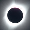
- Solar Eclipse 2024
See the 2024 Solar Eclipse’s Path of Totality
A total solar eclipse is expected to pass through the United States on April 8, 2024, giving stargazers across the country the opportunity to view the celestial phenomenon in which the sun is completely covered by the moon.
The eclipse will enter the U.S. in Texas and exit in Maine. It is the last time a total solar eclipse will be visible in the contiguous United States until 2044.
Here's what to know about the path of the eclipse and where you can see it.
Read More : How Animals and Nature React to an Eclipse
Where can you see the total solar eclipse?
The eclipse will cross through North America, passing over parts of Mexico, the United States, and Canada.
The eclipse will enter the United States in Texas, and travel through Oklahoma, Arkansas, Missouri, Illinois, Kentucky, Indiana, Ohio, Pennsylvania, New York, Vermont, New Hampshire, and Maine. Small parts of Tennessee and Michigan will also experience the total solar eclipse.
Much of the eclipse's visibility depends on the weather. A cloudy day could prevent visitors from seeing the spectacle altogether.

When does the solar eclipse start and end?
The solar eclipse will begin in Mexico’s Pacific coast at around 11:07 a.m. PDT. It will exit continental North America on the Atlantic coast of Newfoundland, Canada, at 5:16 p.m. NDT.
The longest duration of totality—which is when the moon completely covers the sun — will be 4 minutes, 28 seconds, near Torreón, Mexico. Most places along the path of totality will see a totality duration between 3.5 and 4 minutes.
Read More : The Eclipse Could Bring $1.5 Billion Into States on the Path of Totality
Where’s the best place to see the total solar eclipse?
The best place to witness the event is along the path of totality. Thirteen states will be along the path of totality, and many towns across the country are preparing for the deluge of visitors— planning eclipse watch parties and events in the days leading up to totality.
In Rochester, NY, the Rochester Museum and Science Center is hosting a multi-day festival that includes a range of events and activities. Russellville, Arkansas will host an event with activities including live music, science presentations, tethered hot-air balloon rides, and telescope viewings.
More Must-Reads From TIME
- Exclusive: Google Workers Revolt Over $1.2 Billion Contract With Israel
- Jane Fonda Champions Climate Action for Every Generation
- Stop Looking for Your Forever Home
- The Sympathizer Counters 50 Years of Hollywood Vietnam War Narratives
- The Bliss of Seeing the Eclipse From Cleveland
- Hormonal Birth Control Doesn’t Deserve Its Bad Reputation
- The Best TV Shows to Watch on Peacock
- Want Weekly Recs on What to Watch, Read, and More? Sign Up for Worth Your Time
Write to Simmone Shah at [email protected]
- Skip to main content
- Keyboard shortcuts for audio player
Solar eclipse 2024: Follow the path of totality
Thinking of taking a last-minute drive to see the eclipse here's what to know.

Geoff Brumfiel

RV traffic sits at a standstill along a two-lane road near Madras, Ore., a few days before the 2017 total solar eclipse. Experts say traffic could be heavy, but eclipse watchers shouldn't necessarily be deterred. AFP Contributor/AFP via Getty Images hide caption
RV traffic sits at a standstill along a two-lane road near Madras, Ore., a few days before the 2017 total solar eclipse. Experts say traffic could be heavy, but eclipse watchers shouldn't necessarily be deterred.
NASA says that roughly 31.6 million people live in the path of this year's total solar eclipse, and a little under half of the U.S. population lives within 200 miles driving distance of the path of totality .
That could mean many millions of Americans will hit the road to get a better view on April 8. If you're still pondering whether or not you want to make the journey, here's what to consider.
Have some destinations in mind, and check the weather and cloud cover forecasts in advance
It's a good idea to scout out one or more locations within driving distance, so that you have some flexibility if traffic or weather is threatening your plans, says Jonathan Upchurch, a professor emeritus of civil engineering at Arizona State University who has studied travel around solar eclipses.
There are several interactive tools that show the path of totality, including Eclipse2024.org and the National Solar Observatory . You can use them to figure out what sites might work best for you.
In terms of weather, check not just the weather forecast, but also the cloud cover forecast. Some websites, such as Windy.com will predict cloud cover ahead of time, giving you a sense of whether you'll actually be able to see the eclipse in all its glory.

Everything you need to know about solar eclipse glasses before April 8
During the total solar eclipse in 2017, Upchurch says he chose to go to Idaho "because there were some great chances of having sunny skies, and I had the opportunity to be nimble and relocate if I wanted to."
Before driving into the path of totality, make sure your gas tank is full and that you've got everything you need
During the last total solar eclipse in 2017, it's estimated some 5 million people took to the roads, and those numbers will potentially be much higher this year.
Given all that, Upchurch says it's important to make sure you're taking what you need into the path of totality. You should make sure your car is gassed or charged up, and that you have plenty of snacks and water with you in case you get stranded for a while, especially when trying to leave.

Solar Eclipse 2024: Totality stretches from Texas to Maine
Simple tips to safely photograph the eclipse with your cellphone.
Also don't forget to bring eclipse glasses, which must be worn anytime you're looking at the sun, except for the few minutes when it is completely blocked by the moon.
Some state emergency planners also recommend bringing a paper map or road atlas in case cellular networks become overloaded with visitors seeking directions from their phones.

Don't forget your eclipse glasses everyone! Erika Goldring/FilmMagic hide caption
Don't forget your eclipse glasses everyone!
Arrive early and stay late
Once you figure out where you're going to watch the eclipse, and you've got your supplies, try to get there early. Although traffic is likely to be heavier than normal on the morning of eclipse day, it still should be possible to reach many destinations without too much hassle, says Upchurch.
"Leaving is definitely going to be more of a problem," he says. As the eclipse concludes, people will take to the roads all at once to try and get home as fast as they can. In 2017, that led to traffic jams that lasted many hours in some areas. If possible, Upchurch says, people should stay put for a while to try and avoid the worst of the post-eclipse rush, which in 2017 stretched even into the following day in some parts of the country.

Here's what time the eclipse will be visible in your region
And one more thing: If you do find yourself on the move near the time of the eclipse, state officials stress that you should not simply pull over to the side of the road or highway you're driving on. It's important to be parked legally and safely at the moment of totality.
If you're already in the path of totality: Relax and enjoy!
Several major metropolitan areas including Dallas, Indianapolis, Cleveland and Buffalo are already inside the path of totality, so there's no need to seek a better view, Upchurch says. You'll probably have the most fun simply staying where you are.

Shots - Health News
Watching a solar eclipse without the right filters can cause eye damage. here's why.
If you're on the edge of the path of totality, however, you might consider making a short trip to get closer to the center of the eclipse's path.
"If you're within about 40 miles of the center line, you'll have two-and-a-half minutes or more" of complete totality, Upchurch says. It's up to you to decide whether it's worth making the trip to a more central location.
Despite studying the potential hassles of traveling extensively, Upchurch says he's still looking forward to seeing the 2024 eclipse, which he plans to watch from Texas.
"Totality is absolutely spectacular," he says. "If you have a chance to witness it, I would do it."
- 2024 solar eclipse
- eclipse 2024
- 2024 eclipse
- Traffic patterns
- total eclipse
IMAGES
VIDEO
COMMENTS
If you're too busy to create your first animated travel map right now, or you think your friends can wait being WOW-ed by your last amazing trip, join our community. We'll remind you later that your travel photos can still get the attention they deserve. Keep me posted. Create your animated travel map within minutes with PictraMap - a free ...
Create animated maps for video. Free animated map maker.
SmartSHOW 3D - A tool for granular controls. For users who wish to have a bit of granular control for creating an animated travel route map, they can download the SmartSHOW 3D software. There is ...
Animated travel infographics. Zero-config animated maps. Visualize your journey with beautiful animated maps. Perfect for adventurers, travelers, and explorers wanting to showcase their routes and destinations. Hey mate, this site is awesome! As a s/w product mgr myself, this is very well-done! I was googling for something exactly like this for ...
Share your animated travel route map with your friends & families. With Travel Animator, your travel experiences come to life like never before. Create stunning animations of your travel mapping, turning static photos into animated masterpieces that capture the essence of your wanderlust. Plot your journey on interactive travel maps to give ...
Use a map or a photo for your route animation. You can also apply a zoom, chose a vehicle that moves in front of your route and get creative in many ways.Her...
Create Awesome Travel Animation on Google Map using TravelBoast Android / iPhone / iOS app.Android URL: https://play.google.com/store/apps/details?id=io.urob...
Buy me a coffee for personal tips & advice (link above)My Videos using travel map animations:https://youtu.be/ktaOmecRwlY - The #1 Adventure Ride Rulehttps:/...
Download. Fully compatible with Windows 11, 10, 8, 7. Step 1. Pick a Map. Run this animated maps software after installation. Choose the New Project option and go to the Effects tab. Double-click on the Travel Map icon. In the window that pops up, select a map from the built-in collection, ranging from retro to modern with famous sights.
1. Get The Software. First, you need to download SmartSHOW 3D. This reliable tool allows you to customize the map, pins, intro, ending, music theme, and color settings. With their help and correct techniques, creating an animated travel map is pretty simple. 2.
Key Features: User-Friendly Interface: Intuitive & easy-to-use, Travel Animator is designed for travelers of all levels to create travel blogging. Animation Styles: Choose from a variety of animation styles to suit your travel memories. Map Integration: Seamlessly integrate maps into your animations and showcase your route.
Travel Animator is a game-changer! I used to spend hours editing my travel videos, but now, with just a few clicks, I have a masterpiece ready to share. The animated map journey adds a touch of nostalgia and adventure to every video. - Liam P
Route Animation. With roadtripplaner, a versatile travel map generator, you have the ability to personalize your route animation. Customize the color of your route to match your preferences or branding. Choose from a variety of vehicle icons to represent your mode of transportation, making your map even more engaging. Create a visually stunning ...
More than 10 million iOS and Android users worldwide have used TravelBoast since its release. It's been the most popular mobile app in more than 30 countries. Our users are very inventive! In 2022, they blew up TikTok with their fun distance map trend and educational Guess the Empire videos.
Free Online Travel Animation Video Maker. Elevate your travel storytelling with travel animation videos made on FlexClip's free online travel animation video maker, a game-changer in video production that saves you time and money. Be it captivating travel map animation, dynamic travel logo animation, or engaging travel video intro animation ...
Create without limits with a subscription to https://elements.envato.com/?utm_campaign=elements_social_eyt_E2cb0-7bpJg&utm_medium=social&utm_source=YouTube&u...
Find local businesses, view maps and get driving directions in Google Maps.
Icons on the Moscow interactive map. The map is very easy to use: Check out information about the destination: click on the color indicators. Move across the map: shift your mouse across the map. Zoom in: double click on the left-hand side of the mouse on the map or move the scroll wheel upwards. Zoom out: double click on the right-hand side of ...
Tverskaya Area in Moscow. Tverskaya is the main street of Moscow, it starts from the Kremlin and goes north through all Moscow to change into Leningradskoe shosse, which leads to Tver and after 700 km to St. The best way to explore Moscow is to go for a walk in one of the central neighborhoods or parks.
Animated travel infographics. Zero-config animated maps. Watch examples. Visualize your journey with beautiful animated maps. Perfect for adventurers, travelers, and explorers wanting to showcase their routes and destinations. Johnatan Cook. Hey mate, this site is awesome! As a s/w product mgr myself, this is very well-done!
If you're too busy to create your first animated travel map right now, or you think your friends can wait being WOW-ed by your last amazing trip, join our community. We'll remind you later that your travel photos can still get the attention they deserve. Create an animated travel map with PictraMap - a free online tool to share travel photos ...
A total solar eclipse is expected to pass through the United States on April 8, 2024, giving stargazers across the country the opportunity to view the celestial phenomenon in which the sun is ...
NASA says that roughly 31.6 million people live in the path of this year's total solar eclipse, and a little under half of the U.S. population lives within 200 miles driving distance of the path ...
⁴ᴷ Walking tour by car 🚗 to the business center 🏙️"Moscow city" |Russia 🇷🇺Friends, please like. Write a 5 word comment and subscribe. Then the algorithms...