- Share full article
Advertisement
Supported by
California Today

L.A. Opens Its New Light-Rail Link
Known as the Regional Connector, the link allows riders to travel from East Los Angeles all the way to Santa Monica without transferring.
By Douglas Morino

A city famous for its choked freeways and crawling commutes has a new claim to fame: the longest light-rail line in the world.
That’s according to the Los Angeles County Metropolitan Transportation Authority, which opened a 1.9-mile subway tunnel under downtown Los Angeles last week. The tunnel caps a $1.8 billion project that will now allow riders to travel directly between Long Beach and Azusa, a journey of nearly 50 miles, or between Santa Monica and East Los Angeles.
The new link, called the Regional Connector, includes three new underground stations and links three light-rail lines, reducing travel times by eliminating the need for many riders to transfer.
Transit agencies across California and the nation are trying to reinvent themselves after the coronavirus pandemic drastically changed commuting patterns and ridership. Los Angeles leaders hope that by making use of the light-rail network more convenient, they can lure new riders, ease traffic and cut pollution.
“It remakes transportation in Los Angeles County,” Bart Reed, executive director of the Transit Coalition, a public-transit advocacy group, said of the new link. “Anywhere you go, driving is often slow. The truth is that trains are a mobility solution in Los Angeles.”
I rode the newly extended A line recently, from Long Beach through downtown Los Angeles, across Pasadena and into Azusa at the foot of the San Gabriel Mountains. The whole trip took just under two hours at speeds reaching 56 miles an hour. Train cars were mostly uncrowded.
At a time when transit budgets are being squeezed across the country, the Los Angeles County Metropolitan Transportation Authority, known as Metro, is expanding light rail in part because of a series of voter-approved sales tax increases meant to fund such projects, dating back to Proposition A in 1980.
“We’re following the will of the voters,” said Janice Hahn, a Los Angeles County supervisor and a Metro board member. “We’re making a major investment in building out a modern transportation system that connects people to where they want to go.”
With Los Angeles scheduled to hold the 2028 Summer Olympics, officials believe that expanding the light-rail system will better connect cities across the county, the most populous in the nation, while reducing street congestion and carbon emissions.
“There is no other choice, because we’re not going to build new freeways,” said Ara Najarian, a Glendale City Council member and the chair of Metro’s board of directors. “We want to get people out of cars and into safe, reliable transit.”
The expansion also comes at a time when drug overdoses on the trains have been increasing, and a series of travelers aboard Metro trains have been attacked. Violent crime on public transit in Los Angeles County is up about 10 percent from last year, and drug-related offenses have surged 301 percent, according to Metro figures.
Ridership remains below prepandemic levels but has begun to increase steadily. About 23.4 million riders used Metro trains and buses in April 2023, 10 percent more than in April 2022, according to Metro officials. Buses account for more than two-thirds of total ridership.
As my train traveled back to Long Beach, it was rush hour, and many more riders came on board. Metro “ambassadors” — guides wearing lime-green shirts — stood in pairs at station platforms and on train cars, with black pouches of doses of naloxone, a medication used in opioid overdoses, affixed to their belts.
“They have to do something about crime and people being attacked,” said Judy Louie, 69, a Sierra Madre resident riding with her sister to downtown Los Angeles. “It’s appalling.”
Other passengers said a fast and reliable light-rail system had potential in a sprawling region where car culture reigns and public transit is often seen as uncomfortable or inconvenient.
“There’s a stigma,” Bill Teweles, 72, said.
Traveling to Little Tokyo, Teweles said he believed the new Regional Connector would make navigating downtown easier while attracting new riders, easing traffic and helping the environment.
“I’m an optimist,” he added.
Why California transit agencies are rebounding at such different rates.
Douglas Morino is a journalist based in Los Angeles.
The rest of the news
Basketball: At a two-day camp in Los Angeles, current and former N.B.A. players train in the art of broadcasting , podcasting and spinning hot takes on camera.
Movie theaters: The Academy of Motion Picture Arts and Sciences said it would require films to have an initial theatrical run of one week to be eligible for a best picture Oscar.
Bias incidents: There were more than 350 incidents of anti-L.G.B.T.Q. harassment , vandalism or assault in the country between June 2022 and April 2023, according to a new report.
Capitol riot : Daniel Rodriguez, a Southern California resident who assaulted a police officer during the Jan. 6, 2021, attack on the U.S. Capitol, was sentenced to more than 12 years in prison .
Lab-grown meat: U.S. regulators have for the first time approved the production and sale of laboratory-grown meat, allowing two companies based in California to sell chicken produced from animal cells .
SOUTHERN CALIFORNIA
Tech layoffs: Citing decreased demand for smartphones, the tech giant Qualcomm said it would lay off more than 400 employees at its San Diego headquarters in July, KPBS reports.
Nurses gird for strike: After months of failed labor negotiations, 100 percent of the nursing staff at two San Gabriel Valley hospitals have voted to authorize a walkout , The Orange County Register reports.
Metal plant: A metal recycling plant next to a South Los Angeles high school was charged with 22 felony counts , including knowingly disposing hazardous waste without a permit, after decades of complaints from the school, The Los Angeles Times reports.
CENTRAL CALIFORNIA
Shooting lawsuit: The city of Taft did not violate its security contract with the regional school district , a jury in Kern County ruled, after a student shot a classmate on the Taft Union High School campus in 2013, The Bakersfield Californian reports.
NORTHERN CALIFORNIA
Marina Green views: A remediation project in the San Francisco Marina Small Craft Harbor plans to relocate 185 boat slips, obstructing famous views across the bay in the process, The San Francisco Chronicle reports.
Electric car record: Fifty percent of new car registrations in the Bay Area this March were hybrid or electric vehicles , a record for American metro areas, KGO-TV reports.
Where we’re traveling
Today’s tip comes from Jackie Leventhal, who recommends discovering new sights in Golden Gate Park in San Francisco:
“San Francisco’s largest park is well known to many. The park’s mainstays — the Japanese Tea Garden, de Young Museum and many lakes — are well traversed. However, you can walk unguided and discover many other tidbits waiting for you to see. We found a lush fern grove, the first children’s playground in the country, blooming magnolias, the meditative AIDS Memorial Grove and the Janis Joplin Tree. Bikers, skaters, musicians make every stroll a unique happening.”
Tell us about your favorite places to visit in California. Email your suggestions to [email protected] . We’ll be sharing more in upcoming editions of the newsletter.
What we’re reading
The 25 most influential works of postwar queer literature.
We’re almost halfway through 2023! What are the best things that have happened to you so far this year? What have been your wins? Or your unexpected joys, big or small?
Tell me at [email protected]. Please include your full name and the city where you live.
And before you go, some good news
Things are looking up for a California creature that once seemed destined for extinction.
The Santa Cruz kangaroo rat was for decades thought to exist only in a tiny pocket of sandhills in Henry Cowell Redwoods State Park in Santa Cruz County. But scientists have recently identified new populations 25 miles away, The Mercury News reports.
“It was unbelievable,” said Ken Hickman, who detected the elusive subspecies near Los Gatos. “People have been looking for them for years.”
Thanks for reading. We’ll be back on Monday. Enjoy your weekend.
P.S. Here’s today’s Mini Crossword .
Soumya Karlamangla, Johnna Margalotti and Maia Coleman contributed to California Today. You can reach the team at [email protected] .
Sign up here to get this newsletter in your inbox .
Muni Metro LRVs
- Getting Around
Muni Metro Light Rail
Muni Metro is the United States' third-busiest light rail system, operating a fleet of 151 light rail vehicles (LRV) with an average weekday ridership of 173,500 passengers.
The Muni Metro system consists of 71.5 miles (115.1 km) of standard-gauge track, seven light rail lines (six regular lines and one peak-hour shuttle), three tunnels, nine subway stations, twenty-four surface stations and eighty-seven surface stops.
All subway and surface stations are wheelchair-accessible. In addition, many surface street stops are also wheelchair-accessible, often consisting of a ramp leading up to a small platform for boarding. Above ground, there are 24 surface platform stations. Two stations, Stonestown and San Francisco State University, are located at the southwestern part of the city, while the rest are located on the eastern side of the city, where the system underwent more recent expansion as part of the Embarcadero extension and the Third Street Light Rail Project. However, many of the stops on the system are surface stops consisting of anything from a traffic island to a yellow-banded "Car Stop" sign painted on a utility pole.
Muni Light Rail Facilities
Muni Metro has two rail yards for storage and maintenance:
- Green Yard or Curtis E. Green Light Rail Center is located adjacent to Balboa Park Station and serves as the outbound terminus for the J Church, K Ingleside, and M Ocean View lines. The facility has repair facilities, an outdoor storage yard and larger carhouse structure. The facility was renamed for former Muni head Curtis E. Green in 1987.
- Muni Metro East is a newer facility opened in 2008 and is located along the Central Waterfront on Illinois and 25th streets in the Potrero Hill neighborhood, a block from the T Third Street Line. The 180,000 square foot maintenance facility with outdoor storage area is located next to Northern Container Terminal and the former Army Pier.
- The Cameron Beach Yard facility was originally named the Geneva Yard. Born in 1902 as a Market Street Railway facility, it had a large brick office building, adjoining power house and separate car house. The original office and power house structures remain, although unused by Muni. A new shed or canopy was built and dedicated to Cameron Beach, who had been a member of the Muni's Board of Directors. The current yard has a body and paint shop, and houses Muni's F Line cars.
Rail Vehicle Maintenance Group
The Rail Vehicle Maintenance group is responsible for providing clean, safe and reliable rail vehicles in sufficient numbers to provide scheduled service levels to the riding public of San Francisco on a daily basis.
Rail Vehicle Maintenance is responsible for maintaining 151 Breda light rail vehicles, 52 historic rail vehicles and 40 cable cars (28 Powell Line cars and 12 California Line cars). We work safely and efficiently to provide direct on-vehicle maintenance including:
- Daily cleaning and servicing of the vehicles,
- Scheduled preventive maintenance and inspection,
- Repairing defects in the mechanical, electrical, electronic or pneumatic systems,
- Removing and replacing worn or defective components,
- Body work, and
In addition to direct vehicle maintenance the Rail Vehicle Maintenance group maintains a full-service Machine Shop with two satellite locations, Electric Motor Shop, Sheet Metal Shop, Electronic Shop and HVAC repair shop. These support shops repair and overhaul components that have been removed from the vehicles and fabricate new components when necessary. The support shops provide support to the rubber tire fleet, cable car infrastructure as well as light rail vehicles and historic vehicles.
Muni Metro History
On February 18, 1980, the Muni Metro was officially inaugurated, with weekday N Line service in the subway. The Metro service was implemented in phases, and the subway was served only on weekdays until 1982. The K Ingleside Line began using the Metro subway on weekdays on June 11, 1980, the L Taraval and M Ocean View lines on December 17, 1980, and lastly the J Church Line on June 17, 1981. Meanwhile, weekend service on all five lines (J, K, L, M, N) continued to use PCC cars operating on the surface of Market Street through to the Transbay Terminal, and the Muni Metro was closed on weekends. At the end of the service day on Sunday, September 19, 1982, streetcar service on the surface of Market Street was discontinued entirely, the remaining PCC cars taken out of service, and weekend service on the five light rail lines was temporarily converted to buses. Finally, on November 20, 1982, the Muni Metro subway began operating seven days a week. Current Muni metro service has expanded along the waterfront south of the Embarcadero and onto Third Street where it now terminates at the city line.
Visit our Muni History page for more information about San Francisco's transit.
- Meetings & Events
- Minneapolis Convention Center
- Sports Minneapolis
- Things To Do
- Eat & Drink
- Plan Your Trip
- Nature & Outdoors
- Music & Nightlife
- Arts & Culture
- Itineraries
- Casinos & Gaming
- Health & Wellness
- Amusement & Waterparks
- Classes & Experiences
- Festivals & Fairs
- Top Events by Season
- Downtown Minneapolis
- Minneapolis Restaurants
- Beer, Cocktails and Wine
- Coffee Shops, Bakeries & Sweet Treats
- International Cuisine
- Farmers Markets & Food Trucks
- Minneapolis Bars
- Downtown Core
- Northeast Minneapolis
- South Minneapolis
- Dinkytown and Surrounding U of M Area
- West Bank & Cedar Riverside
- All Neighborhoods
- Maps & Transportation
- Accessibility Guide to Minneapolis
- Neighborhoods
- Explore the Cultural Districts
- Minneapolis LGBTQ+ Community
- Minneapolis Black Community
- Visitor Guide
- Subscribe to Our Newsletter
Minneapolis Light Rail & Bus Information
Metro Transit operates one of the largest public transportation systems in the country.
Riding public transit is a convenient and inexpensive way to get around. Fares range from $2 to $3.25, depending on time of day. You can pay bus fares in exact change in coins and bills, with a Go-To Card or with the Metro Transit app.
Metro Transit offers fast, frequent service to both downtowns, Mall of America and hundreds of other popular attractions. For an extremely efficient way to travel, get around town on the METRO Blue and Green light rail lines and the A and C bus rapid transit lines. The METRO Blue Line connects downtown Minneapolis with the airport and Mall of America, and the METRO Green Line connects downtown Minneapolis, the University of Minnesota and downtown St. Paul.
Downtown Zones :
These are special zones in downtown Minneapolis and downtown St. Paul. If your trip stays within these zones you pay just 50¢. It's great for riding just a few stops on buses and on METRO Blue and Green lines. Pay on board buses or buy a Downtown Zone ticket at METRO station ticket machines.
Metro Transit 7-Day Pass
For just $24, enjoy a week of touring with a 7-Day Pass. It's good for unlimited rides on Metro Transit buses and METRO lines (not valid on Northstar Commuter trains). Metro Transit offers fast, frequent service to both downtowns, Mall of America and hundreds of other popular attractions.
The 7-Day Pass is easy to use. Just tap the card on the reader as you board the bus or METRO stations. It's valid for 7 days from first use. Simple!
7-Day Passes are available online or at any Metro Transit service center .
Taking the Train to a Game or Event?
All-day pass.
Make it easy to get there and back. Buy an All-Day Pass for an easy return trip.
For one low price, you'll get unlimited rides on buses or light rail. It's enough time to take in a game, a concert or another event. When you're ready to come back, you won't have to wait in line to buy a return ticket - no waiting, just hop on!
An All-Day Pass can be used for unlimited local bus, light rail and off-peak express rides from the time of purchase through 2 a.m. the next day.
Adults can buy an All-Day Pass for $4.00-5.00 on weekdays (depending on time of day), $4.00 on weekends. For youth, seniors and Medicare card holders, prices are $2.00-$5.00 on weekdays and $2.00 on weekends . All-Day Pass prices are $2.00 at all times for persons with disabilities.
To get your All-Day Pass for the train, press Key G on the ticket machine at the light-rail station before you insert your credit card or cash. Note: all tickets from the ticket machine are valid from time of purchase.
METRO Light Rail
The METRO Blue Line offers fast, quiet light-rail service between downtown Minneapolis and Mall of America.
Dozens of bus routes are timed to connect with trains at Blue Line stations, making it easy to get to events, to shopping or wherever you need to be.
The METRO Green Line has many destinations to choose from: the history of the Capitol City, the cuisine along University Avenue, the energy of the University of Minnesota campus, the bustle of downtown Minneapolis. Check out this Light Rail Beer Crawl and experience 19 different taprooms along the Green Line.
The METRO Blue & Green lines trains charge the same fares as local buses. Light rail trips operate frequently throughout the day. Real-time arrival signs at stations display when the next train is due.
Free Ride Buses
Look for buses marked “Free Ride” and pay no fare when boarding along Nicollet Mall. You’ll have an easy ride between the Convention Center and the METRO Blue and Green lines on 5th Street.
Ride for free from the Minneapolis Convention Center here:
- board a northbound Route 18 between Nicollet & Grant to Hennepin & Washington
- get on a southbound Route 10 between Hennepin & Washington and the Convention Center
Free Ride buses travel north into downtown Minneapolis and end at Washington Avenue. They are available seven days a week.
This Website uses cookies to enhance your visitor experience. Learn More
Quick Search
Top searches.
- Plan A Trip
- Minneapolis Community Safety Updates
- Music & Nightlife
- Eat & Drink
- Downtown Minneapolis & Area Maps
Location Map

Frequently Asked Question Reports (FAQs)
The FAQ Reports below provide detailed information and analyses grouped by topic.
COST / BUDGET
Federal process, (national environmental policy act) faq.
Information about the federal process, timeline and analysis of proposed design options.
Ridership FAQ
Ridership estimates for each option, by station, based on modeling data as of February 2023.
Finance FAQ
A funding plan for the development, construction, operations, and maintenance of light rail.
On-Street FAQ
A report detailing the opportunities and challenges for an on-street light rail option.
Expandability FAQ
An analysis of the future expansion to the core light rail system.
Are on-street light rail options safe?
Light rail operations (both on-street and grade-separated) are designed and managed to operate safely as proven in on-street and grade-separated systems all over the US and world. Any light rail project based on its complexity with other modes moving through a city such as pedestrians, cyclists, automobiles, buses, etc. will be subject to risk analysis, safety reviews and must be safety-certified before operations.
What is the ASMP?
The Austin Strategic Mobility Plan (“ASMP) was adopted in 2019 and is Austin’s first comprehensive, multimodal transportation plan, and guides our short- and long-term transportation projects, programs, initiatives, and investments. The ASMP plans for managing all the ways we get around Austin by including future goals for the number of people using various modes of transportation. This includes driving, walking, bicycling, rolling, and public transportation. High-capacity transit is key to reaching our mobility, affordability, and environmental goals.
Has COVID changed the way people travel?
Some riders, including essential workers, have and will continue to ride transit no matter what. Ridership on all modes in the existing CapMetro system has returned to roughly 80% of pre-pandemic levels and continues to grow each month. We are continuing to collect data on travel patterns as it emerges, to make sure we are responsive to travel demands of our community.
How does on-street light rail work, and how can traffic impacts be managed?
Please see our On-Street FAQ report for more detailed information on this topic.
What are expandability opportunities & challenges with the light rail options?
Please see our Expandability FAQ report for more detailed information on this topic.
Why are we discussing one lake crossing instead of two?
The lake crossings are one of the most expensive components of the system, and it was determined that crossing Lady Bird Lake once for the initial core light rail system, as opposed to twice, is a viable solution to reducing costs.
About the Options
Options reference increase/decrease in light rail travel time. by how much.
Light rail travel times are based on a variety of factors including but not limited to the following: how frequently does the service stop (at stations), travel speed, separation from or interaction with other traffic, and alignment geometry (curves), etc. The various light rail options all have different factors that may impact travel time speeds, including underground or elevated options downtown to separate light rail from the street level versus interactions with other modes, such as drivers, bicyclists, and pedestrians at intersections.
For trips THROUGH downtown, the options that are on-street rather than grade separated (underground or elevated) add travel time to a light rail trip.
For trips TO/ FROM /WITHIN downtown, this additional travel time in the on-street options is reduced through quicker access to station platforms (boarding and off-boarding) without the need for stairs/ escalators/ elevators to access the stations.
Light rail travel times should not be reviewed in isolation and should be considered relative to speed and comfort of other modes as light rail becomes a transportation choice. Light rail and vehicular traffic operations will continue to be studied as the project advances.
Why aren’t any options extending to South Congress Transit Center or Stassney?
Options extending to South Congress Transit Center or further south to Stassney would require a maintenance facility sited near South Congress Transit Center. The southern maintenance facility alternative that was analyzed would require a substantial number of business displacements, major utility relocations and relocation of the Bergstrom Spur trail. The south maintenance facility also has additional complexity to connect to the main light rail corridor. These characteristics lead to a higher cost for options extending to the south and preclude the ability to reach high ridership stations at UT and Pleasant Valley within the budget envelope. The current budget would not allow us to reach either of the other maintenance facility alternative sites (North Lamar Transit Center or near Riverside at SH 71).
Why is the NLTC option only at-grade through downtown?
The major factor used to determine the at-grade features of the “On-Street: North Lamar to Pleasant Valley” option was cost. Grade-separating (taking the light rail up or down) increases costs, and the length of this option precluded the ability to grade-separate.
Will these options be taking traffic lanes for light rail?
Retrofitting right of way to accommodate all modes of transportation is something the City of Austin has been doing well for over a decade. We will take a similar approach for balancing traffic lane modifications for light rail. In some options, where right of way is limited, vehicle lanes may be reduced to accommodate the light rail.
What are the noise considerations for these options downtown?
Operation of the light rail can cause noise, however light rail operations are traditionally quieter than commuter rail—like the Red Line—because they are lighter in weight, all-electric, less disruptive in urban environments where there is existing background noise such as vehicular traffic. As design progresses, noise studies will be completed and potential impacts and proposed mitigation shared with the community.
Will the boathouse be impacted in either river crossing option?
The Trinity St. Crossing option would impact the boathouse. The project team is coordinating with Parks and Recreation Department (“PARD”) about this possibility.
What does it mean for the on-street options to require a trench from 7th to 9th Streets on Guadalupe? Similarly, what would be required for transitions to elevated/ underground along Guadalupe?
The on-street options through downtown require a light rail trench from 7th Street to 9th Street along Guadalupe due to the hill that is too steep for light rail operation. The trench would prevent through traffic along 8th Street to cross Guadalupe, meaning drivers traveling along 8th Street would have to turn on Guadalupe Street rather than travel straight across Guadalupe Street. An illustration of the trench concept is shown in the image below and would continue to be refined as design advances.
Cost/Budget
What is the cost / budget of the project.
Please see our Finance FAQ for more detailed information on this topic.
Why not just improve the bus service?
Transit systems are most effective when multiple services and transit modes are employed, each providing a critical function within the overall system. Bus service provides the most flexibility of the modes and provides the transit system with broad reach into the community. Light Rail – with a dedicated guideway – will serve as a fast, high-capacity transit spine that provides reliability, capacity, and speed not present in the current bus network. These systems complement each other to provide the community with multiple transportation options.
What will the existing bus system look like after light rail is built?
Although not yet determined, the existing bus service will be modified to complement and feed the light rail line. Bus routes will be connected at key hubs, transfer points and at stations along the light rail route. Local bus service may also continue based on level of frequency and connectivity needs that may vary along the corridor. The bus and MetroRail services will be reviewed holistically to best support the full transit network when light rail opens.
What is the timeline for NEPA (National Environmental Policy Act)/ROD (Record of Decision), construction, opening?
Following the current process to affirm the light rail project definition in May/ June 2023, the project team will work with FTA to analyze project impacts and advance the NEPA process. We anticipate coming back to the public with a Draft EIS in 2024. Final design and construction schedules that would follow the completion of the NEPA process will be informed by the delivery models ATP is considering.
Will construction occur at the same time as I-35?
Likely, yes, there will be overlapping construction schedules. Various mobility and safety projects are scheduled for construction throughout Central Texas over the next 10 years. Agencies such as ATP, CapMetro, the City of Austin, CTRMA, TxDOT and others will be closely coordinating construction schedules and outreach plans to ensure our city keeps moving. Each of these entities are jointly partnering in the Construction Partnership Program to create a centralized source of coordination and communication regarding construction impacts throughout the City.
- 512-389-7590
- [email protected]
- Ethics Hotline
- Public Information Act
- Conflicts of Interest
- Diversity, Equity and Inclusion
- Submit Complaint
- Internal Audit
- Transportation
- Write for Us
- Newsletters
- Board of Directors
- Elections Committee
- Advertise with Us
- Privacy Policy
- Link light rail
Metro and Sound Transit Unveil Proposed East Link Bus Restructure

Author’s Note: Some information in this article has been updated based upon new information from King County Metro. Several pieces of information are still subject to change since some route-level information remains incomplete on the online open house.
In 2023, light rail will reach the Eastside with Sound Transit’s newest extension: East Link (to be known as the 2 Line). This is precipitating further bus restructures among King County Metro and Sound Transit bus networks. Service planners are targeting better bus-to-light rail connections while maintaining good local service and achieving equity goals. The bus restructure process is in its second public phase with formal draft proposals , which would affect bus routes throughout the Eastside and could impact routes originating as far away as Seattle, Shoreline, and Renton.
The proposed bus restructure is best thought of as five subareas, which the transit agencies have neatly developed information around. Those include:
- Seattle Subarea (Seattle);
- South Subarea (Renton and Newcastle);
- Central Subarea (Bellevue, Redmond, and Issaquah);
- East Subarea (I-90, Mercer Island, Sammamish, Snoqualmie, and North Bend); and
- North Subarea (Kirkland, Bothell, and Woodinville).

More than 40 bus routes could be affected by the restructure proposals and cover 19 different cities. The 2 Line extension will deliver ten new stations in four cities by 2023 and two additional stations in Redmond in 2024, providing service from Northgate all the way to Downtown Redmond via Capitol Hill and Downtown Seattle. Light rail travel times are estimated to be 18 minutes from Downtown Redmond to Downtown Bellevue, 24 minutes from Downtown Bellevue to Westlake Station in Downtown Seattle, and 50 minutes from South Bellevue to Seattle-Tacoma International Airport.
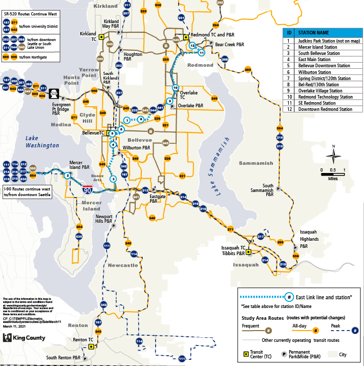
In developing the proposals, Metro initially sought general feedback earlier this year from the public and directly engaged with a 27-member Mobility Board. Key themes that came out of that process were a desire for more local connections, reasonable transfers, keeping fast travel times, additional weekend and off-peak service, and a focus on primary locations like Downtown Bellevue and Redmond, Microsoft’s campus, colleges, and the Spring District.
Seattle Subarea proposals

The Seattle Subarea only encompasses one principal change and that’s to the southern portion of Route 8 . Metro wants to better serve Judkins Park Station by providing another direct connection to the station. Under the existing network, Routes 7, 9, 48, and 106 directly pass by Judkins Park Station, but only Route 48 offers a regular connection for people living in Capitol Hill, Central District, and other Central Seattle areas. Route 8, for its part, operates along Martin Luther King Jr. Way, which is at least four blocks away from Judkins Park Station.
To provide a better connection, Metro is proposing that Route 8 be revised to fully serve 23rd Avenue S south of S Jackson Street. This would allow the route to pick up Judkins Park Station on its way to Mt. Baker Station and Mt. Baker Transit Center. The route would also run on Rainier Avenue S between the two light rail stations. However, this would mean that some stretches of Martin Luther King Jr. Way would lose frequent bus service north and south of I-90. Route 4 partially compensates for this, but it doesn’t fully solve the problem.
Metro could choose to revise Route 8 off of Martin Luther King Jr. Way further south than currently proposed and still send buses to 23rd Avenue S to pick up Judkins Park Station and then weave back to Martin Luther King Jr. Way, but that would mean using less developed streets, possible removal of street calming features, and slowing buses down with turns. That could be slightly ameliorated by removing the E Yesler Way jog though.
South Subarea proposals
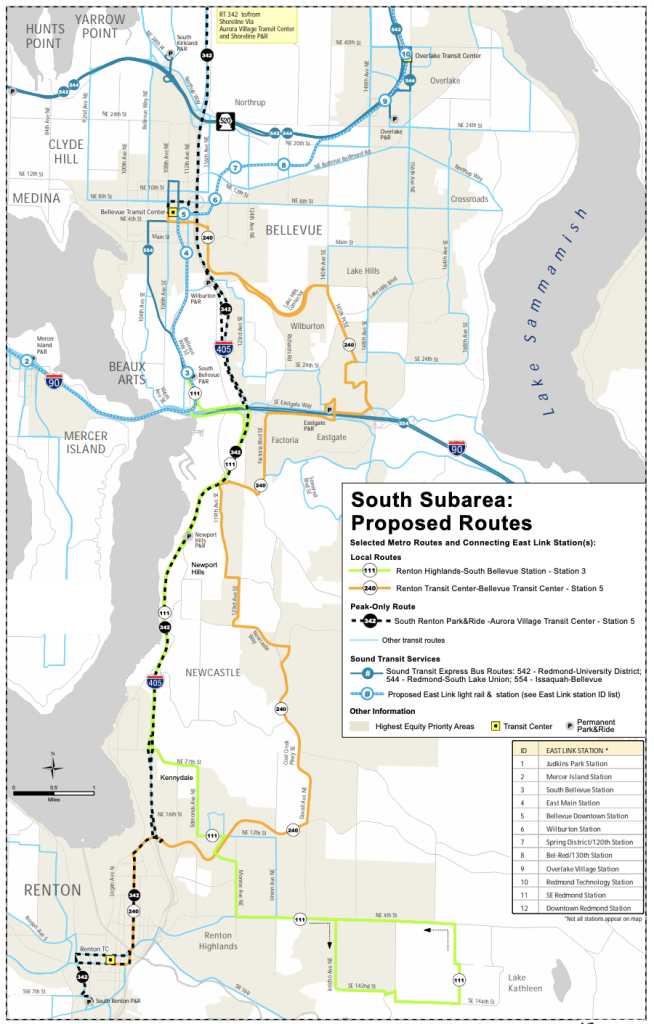
The big ideas for the South Subarea proposal are a strong connection to the future South Bellevue Station and bidirectional Route 342 from Renton to Shoreline. The proposal involves changes to five routes, including the elimination of peak-only Routes 114 and 167. The latter two routes would essentially be consolidated to a shortened Route 111 with improved span of service. As for Routes 240 and 342, these routes would see alignment revisions mostly in Bellevue with some minor changes in Renton.
Central Subarea proposals
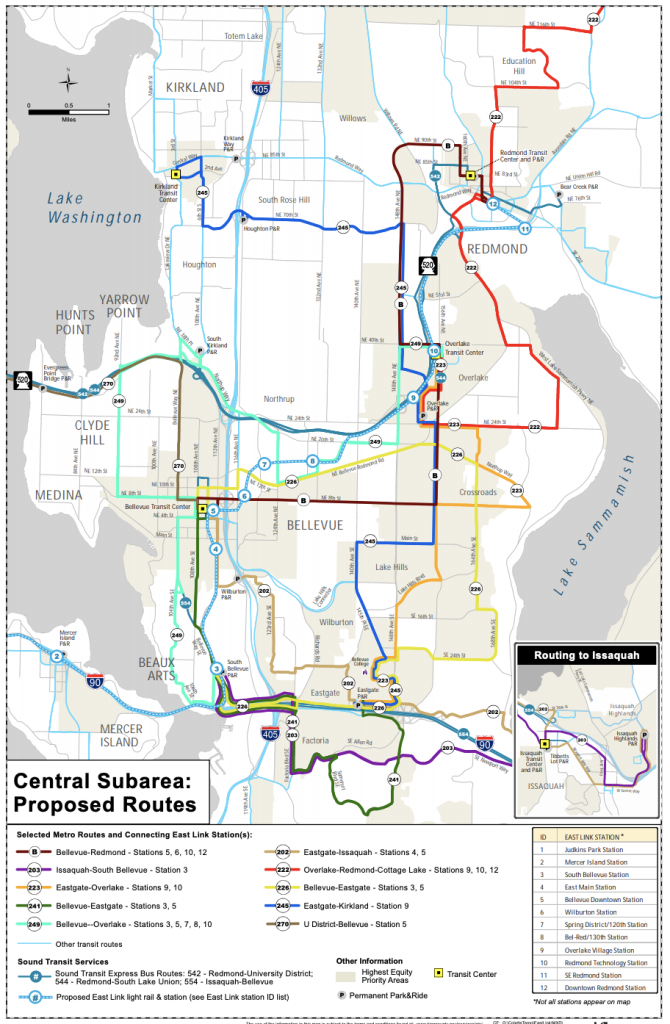
The big ideas for the Central Subarea are: connections to the many light rail stations Bellevue and Redmond are getting; wider Central, South, and East Bellevue coverage; and better connections to and service in Issaquah. This proposal involves creation of several new bus routes and consolidation of many others. Strong poles for service would be Bellevue College, Eastgate Park-and-Ride, Crossroads, and the future South Bellevue, Downtown Bellevue, Overlake Village, and Redmond Technology Stations.
East Subarea proposals
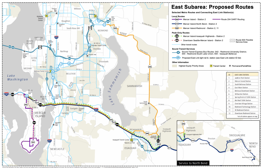
The big ideas for the East Subarea changes are a focus on Routes 218 and 269 as well as new Route 215. Many weekday peak hour routes would be consolidated so that they rely on Routes 215, 218, and 269 to reach the future Mercer Island Station and continue onward to Seattle. Combined, these routes would provide service as frequent as every five minutes to the station during peak hours. Overlaid on top of this is Route 554 that would run frequently between Downtown Bellevue and Sammamish via I-90 and Issaquah, which would provide service to the future South Bellevue Station and Downtown Bellevue transit center and station.
North Subarea proposals
The big ideas for the North Subarea are a new local Woodinville-to-Redmond and peak-hour Woodinville-to-Downtown Seattle route. Currently, Redmond and Woodinville have no direct connection, but new service would tie them together and allow riders from Woodinville to access to light rail. Additionally, a new peak-hour route would consolidate three existing varieties from Kirkland and Woodinville to Seattle.
Engagement opportunities and next steps
Through October 18th, Metro and Sound Transit will be hosting an online open house . The public can further review the proposals through the online open house and offer feedback on specific routes. Two virtual community forums will also be held on Saturday, September 18th at 10:00am and Wednesday, September 29th at 6:00pm. Once the second outreach process has wrapped up, the agencies will engage with the Mobility and Partner Review Boards and then further revise the proposals. The agencies will then offer a final recommended restructure proposal this winter. Approval of the changes could come by spring or summer next year.
Metro Begins East Link Bus Restructure Process Affecting 42 Routes
Stephen Fesler
Stephen is a professional urban planner in Puget Sound with a passion for sustainable, livable, and diverse cities. He is especially interested in how policies, regulations, and programs can promote positive outcomes for communities. With stints in great cities like Bellingham and Cork, Stephen currently lives in Seattle. He primarily covers land use and transportation issues and has been with The Urbanist since 2014.
light-rail Blue Line
Branham Escalator Out of Service
Great mall station elevator #1 out of service.
light-rail Green Line
light-rail Orange Line
Orange Line: Bus Bridge Due to Light Rail Rehab (04/24/24-04/28/24)
frequent Rapid 522
Routes 22, 64B & 522: Reroute Due to Preston Pipelines Construction - 4/16/24-5/26/24 (7:00PM-5:30AM)
frequent 22
Route 22: Temporary Bus Stop Closure at El Camino & Rengstorff (03/01/24-11/01/26)
Frequency chart.
Learn more about the frequency of Light Rail, Rapid Bus, Frequent Bus, Local Bus, and Express Bus trips with our Frequency Chart.
Service Alerts
- Find your route on our Service Alerts page
- View alerts at the top of your route’s page .
- Subscribe to real-time service alerts for your routes in the Transit app .
School Trippers
Learn more about VTA's special school service routes, including 246, 247, 255, 256, 270, 287, 288, 288L and 288M.
Frequently Asked Questions
What are timepoints on bus and light rail schedules, can i bring my bike on the bus/light rail, does vta bus and light rail service operate on holidays, do rapid buses (500, 522, 523, 568) follow a schedule, how to i claim something i lost on vta, how do i start riding vta, does light rail stop at every station, even if it's not listed on the schedule.
- KIRO Opinion
- KTTH Opinion
- KIRO Newsradio 97.3 FM
- Seattle Sports
- 770 KTTH AM
- MyNorthwest News
- MyNorthwest Weather
- MyNorthwest Traffic
- MyNorthwest History
- MyNorthwest Politics
- MyNorthwest Lifestyle
- National News
- Photo Galleries
- Sponsored Stories
- Gee and Ursula
- Jack and Spike
- John and Shari
- KIRO Nights
- Jason Rantz
- Bryan Suits
- Michael Medved
- MyNorthwest Blog
- Brock and Salk
- Bump and Stacy
- Wyman and Bob
- Search the Site
- Earthquake Tracker
- School Closings
- Advertise With Us
- Contest Rules
- Newsletters
- Contests and Events
- Community Outreach
- X (Twitter)
- KIRO on YouTube
- KTTH on YouTube

CHOKEPOINTS
It’s not the whole enchilada, but light rail to roll on Eastside this month
Apr 11, 2024, 6:46 AM | Updated: 7:06 am

Signs in the eight light rail stations will provide real-time travel data for trains and destinations. (Photo: Chris Sullivan, KIRO Newsradio)
(Photo: Chris Sullivan, KIRO Newsradio)

BY CHRIS SULLIVAN
KIRO Newsradio traffic reporter
Light rail service on the Eastside begins later this month, but it’s going to be another year before the trains actually cross Lake Washington.
The eight stations are ready to roll. Test trains are running on the tracks. The operators are training. Service on the Sound Transit starter line between south Bellevue and the Microsoft campus in Redmond begins Saturday, April 27.
While not the full ride from Seattle to Redmond that Sound Transit promised, Jon Lebo, the executive project director, said it’s a good start.
“I think for the public it’s the realization that we are going to have light rail on the side, and they’re going to see the advantages of having this kind of system in their backyard,” he said while surveying work at the south Bellevue station this week. “I think the next step is to bring it across the lake, and it will be absolutely fabulous.”
More Chokepoints content: Washington begging drivers to slow down in work zones to avoid crashes
The full 2 Line , which is now the name for the East Link extension , was supposed to open in 2023 under the latest estimates.
You throw in the COVID-19 pandemic and bad concrete, and you get the delay Sound Transit is working with today. The agency had to pull up all the tracks on the Interstate 90 (I-90) floating bridge and replace the more than 5,000 concrete plinths that held them up.
The agency tried to repair them, but it eventually had to replace them.
Where are we on that process now?
“We’re about 75% done with the track work that needs to be reconstructed,” Lebo said.
I asked Lebo his thoughts on that concrete issue and how it was handled. “It’s very disappointing,” he said. “It’s very disappointing both in terms of what work was done by the contractor. There are things that we would do in hindsight, and I think we’re doing them right now.”
From Chris Sullivan: A course in roundabouts; they are not that hard
And he believes they have taken the proper steps to keep this from happening again. “We have full time inspection on all of the concrete work that’s going in so we know for sure that the work has been done correctly,” Lebo said.
I spoke with Redmond Mayor Angela Birney about the upcoming opening while touring the south Bellevue station. Her hope for this starter line is that it gets people thinking about and using light rail as they wait for the line to Seattle to open. “I know it’s not the full meal or the full the full enchilada or whatever you want to call it, but it’s really an opportunity for people to get used to riding light rail that maybe have never used it before,” she said.
There are about 1,500 parking spots at the south Bellevue station.
The 14-mile light rail extension from Seattle to Redmond has a price tag of $3.7 billion. It is currently running five years behind schedule. It was approved by voters in 2008.
Check out more of Chris’ Chokepoints here . You can also follow Chris on X, formerly known as Twitter . Head here to follow KIRO Newsradio Traffic’s profile on X .
Chokepoints

Chris Sullivan
Sullivan: I-405 expansion to widen freeway in Bothell is underway
We've all seen I-405 expanding between Bellevue and Redmond, but construction to widen the freeway north of Bothell is now underway as well.

Nate Connors
I-5 repair work to slow spring breakers, baseball fans this weekend
Beginning Friday night, three lanes of I-5 north between Albro Place and the West Seattle Bridge through Monday morning at 5 a.m.

Has your insurance gone up? Rates can take a hike for distracted drivers
April is Distracted Drivers Awareness Month. The President of NW Insurance Council says it has been working on prevention for years.

Steve Coogan
Military vehicle accident on I-5 north in Federal Way cleared after snarling traffic
A rollover vehicle accident Wednesday caused significant backups and delays for multiple hours before being cleared.

Micki Gamez
RapidRide G Line: A new bus route connecting riders to mass transit
King County Metro's (KCM) Al Sanders said the RapidRide G Line will kick off shortly after the Lynwood extension is done in early September.

All Seattle I-5 north lanes to close Tuesday night
The Washington State Department of Transportation is closing all lanes on I-5 north Tuesday evening in downtown Seattle.
Sponsored Articles

Discover MoPOP’s new exhibit: ‘Massive: The Power of Pop Culture’
The Museum of Pop Culture invites you to experience pop culture like never before with its new exhibition "Massive: The Power of Pop Culture."

Salk: A local credit union inspiring its community
In the heart of Kitsap County, a financial institution is making waves not just as a banking entity but as a beacon of community support.

This checking account is better than gold
My journey led me to Kitsap Credit Union, a not-for-profit, forward-thinking financial co-op that’s been serving its members since 1934.

Punts for Purpose: Brock Huard, other NFL players fight to end global child poverty
Seattle Sports host Brock Huard joins other NFL punters in partnership with Compassion in a cause now known as “Punts For Purpose.”

As crime crisis worsens, locals get serious about personal safety
Washington's crime crisis continues to worsen, and locals are turning to whatever tools they can use to keep them safe.

2024 Medicare open enrollment: Here’s how to get free unbiased help
Medicare’s annual open enrollment period runs Oct. 15 through Dec. 7. This is the time to review your current Medicare coverage.
StarTribune
Light-rail project encounters new obstacle in minneapolis' north loop: major utility lines.
Transit planners say two major Xcel Energy underground electric transmission lines will need to be moved to make way for the $3 billion Blue Line light-rail extension in Minneapolis' North Loop neighborhood. The recent disclosure has raised questions about the cost and time needed to move the lines, which provide power to parts of downtown Minneapolis.
Officials with the Metropolitan Council and Hennepin County say they're confident a solution can be reached with Xcel, and that these kinds of discoveries are routine when building a major transit project in a complex urban environment.
"We look at it as just normal coordination [with utilities], although this one takes a little more work," said Nick Landwer, Metro Transit's director of transit system design and engineering. "We're working with the Xcel team to simplify how to get the work done. It doesn't pose an issue at all."
Project opponents were not appeased: "It's just another example of the Met Council not doing their due diligence on these projects," said Matt Bruns, who lives in the 918 Lofts along 10th Avenue, now part of the Blue Line extension route in the North Loop.
Xcel's transmission lines run under 10th Avenue between 7th Street and Washington Avenue, part of which is expected to be used as a transit mall for light-rail trains and a bike and pedestrian trail. Vehicle traffic will be rerouted elsewhere in the area, although it's not known yet where.
The North Loop stretch is a relatively late addition to the project's route after Lyn Park residents complained two years ago about the previous alignment along Lyndale Avenue, west of Interstate 94. The overall 13.5-mile route, which stretches from Target Field to Brooklyn Park through north Minneapolis, Robbinsdale and Crystal, is expected to begin service in 2030.
Because Xcel's transmission lines are located in a public right of way — in this case a city street — the utility will assume the cost to move them, said Dan Soler, Hennepin County's director of transit and mobility.
At this point, officials are unclear how much that would cost. The project has a bottom line estimated at $2.9 billion to $3.2 billion.Construction is expected to begin in 2027.
"Because it's a transmission line, it does take a little longer to relocate," Soler said. "But it doesn't affect the cost of the light-rail project. We have to build it into our schedule. We've got a tremendous amount of experience with this kind of thing."
Soler said there were complexities rerouting utilities in downtown St. Paul and along University Avenue for the Green Line light-rail project, which began service nearly a decade ago. "You have to get in there and investigate early to see what's there," he said.
Xcel Energy spokesman Theo Keith said the utility has had preliminary discussions with transit planners and the city about the transmission lines. "This process is in the very early stages, and we're committed to continuing to work with stakeholders on a way forward," he said in an email.
But Bruns and others have been apprehensively following the fallout from the $2.9 billion Southwest light-rail line under construction between Target Field and Eden Prairie, which is more than $1 billion over budget and nearly a decade behind schedule. Cracks and flooding at the Cedar Isles condominium complex during light-rail construction in the Kenilworth corridor in Minneapolis, as well as the recent revelation that rail tracks in that area were installed improperly "are very concerning," he said.
Those opposed to the 10th Avenue alignment have proposed an alternate route closer to Interstate 94 that is less disruptive to the neighborhood. That alignment "avoids some things but it doesn't serve as many people," Soler said. "Certainly there are people who would prefer it." Others, including a group in Robbinsdale, have suggested scrapping light rail in favor of bus-rapid transit service.
Some in the North Loop like the 10th Avenue transit mall concept, including the North Loop Neighborhood Association's Planning and Zoning Committee.
Minneapolis City Council Members Jeremiah Ellison and Michael Rainville, whose districts include part of the North Loop, did not respond to requests from the Star Tribune for comment.
The original route for the Blue Line extension, which largely operated alongside BNSF Railway freight trains, did not serve the North Loop or much of north Minneapolis, and was abandoned in 2020 after the rail giant refused to share its right of way. Transit planners then pitched a different route that better served north Minneapolis.
But that route proved controversial among neighbors in Lyn Park along Lyndale Avenue N., who said light-rail service would divide their neighborhood and be unsafe. Transit planners regrouped and came up with the North Loop route east of Interstate 94, which calls for a new bridge over the highway into north Minneapolis.
"I'm hoping that [10th Avenue] route is viable or something similar is," said Lyn Park resident Eva Young at a recent Blue Line extension advisory committee meeting. "I don't want the Lyndale route to come back to haunt us."
Transportation reporter Janet Moore covers trains, planes, automobiles, buses, bikes and pedestrians. Moore has been with the Star Tribune for 21 years, previously covering business news, including the retail, medical device and commercial real estate industries.
- Burnsville woman's sinus surgery went great — until she got the $32,449 medical bill
- Naz Reid's path to breakout stardom featured mentor unlike any other
- Rep. Omar's daughter arrested, suspended from college for pro-Palestinian protests
- How an inappropriate columnist marred Caitlin Clark's news conference
- Hopkins parents charged in 9-year-old daughter's asthma death
- 12 jurors have been picked for Donald Trump's hush money trial. Selection of alternates is ongoing

Trail section at one of Minnesota's most iconic spots closing for rehab

Will 'shotgun only' zone for deer in southern Minnesota be abolished?

Four Minnesotans catch salmonella in outbreak linked to basil sold at Trader Joe's

Rep. Omar's daughter arrested, suspended from college for pro-Palestinian protests
Hopkins parents charged in 9-year-old daughter's asthma death.
![The Kenilworth Corridor between 21st Street and Cedar Lake Parkway. ] GLEN STUBBE • glen.stubbe@startribune.com Friday, April 19, 2019 Pretty s](https://arc.stimg.co/startribunemedia/ME26TIQV6VZPFS3OLZ5GTCCIZE.jpg?w=600&h=600&auto=format%2Ccompress&cs=tinysrgb "light rail travel times")
- Bill would give MnDOT the lead on big transit projects, not the Met Council Apr. 4
- Cost of Blue Line extension could exceed the Southwest light rail Feb. 28
- North Loop group opposes latest route for Blue Line LRT extension Sep. 23, 2023
- Grassroots groups team up to oppose big Twin Cities area transit projects Jul. 29, 2023
- Hopkins parents charged in 9-year-old daughter's asthma death • Local
- Ex-Minneapolis officer Thomas Lane finishes federal prison time in George Floyd killing • Minneapolis
- Back to blue: Lake Harriet Band Shell renovation almost finished • Local
- Four Minnesotans catch salmonella in outbreak linked to basil sold at Trader Joe's • Local
- St. Olaf talks death in a cafe setting • Local
© 2024 StarTribune. All rights reserved.

Flight Time Calculator
Flying time between cities.
Travelmath provides an online flight time calculator for all types of travel routes. You can enter airports, cities, states, countries, or zip codes to find the flying time between any two points. The database uses the great circle distance and the average airspeed of a commercial airliner to figure out how long a typical flight would take. Find your travel time to estimate the length of a flight between airports, or ask how long it takes to fly from one city to another.
You can also search for the closest airport to any city in the world or check the flying distance between airports. If you're thinking about a road trip, compare the driving time for the same route.
Home · About · Terms · Privacy

- World of Warcraft
- Baldur's Gate
- League of Legends
- Counter-Strike
- Ethics Policy
- Ownership Policy
- Fact Checking Policy
- Corrections Policy
- Affiliate Policy
All Fire Chakra quests in Fortnite Avatar Elements
The quests featured in the Avatar Elements Fortnite event take you on a journey with all four elements. One of the elements you practice with is fire during the Fire Chakra quests.
When you get to these tasks, it’s time to start your Firebending journey with Zuko, which means you must tackle some quests inspired by this element. Here are all the Fire Chakra quests featured in the Fortnite Avatar Elements event and how to complete them.
All Fortnite Fire Chakra quests in Avatar Elements event
The Fire Chakra series of quests for the Avatar Elements event has six quests you must complete. These quests follow the Water Chakra and Earth Chakra tasks and are a crucial step on the way to opening all six Chakras .
- Destroy objects or structures at an Elemental Shrine.
- Light a campfire.
- Eliminate opponents in different matches.
- Travel distance on the Train.
- Destroy a Cabbage Cart with Firebending.
- Deal damage to opponents with Firebending.
How to destroy objects or structures at an Elemental Shrine in Fortnite
You can destroy objects or structures at an Elemental Shrine by visiting one of the eight available locations around the map and destroying the shrine itself . Since each Elemental Shrine has some Mythic bending you can pick up, you can use the item you find there to help you tackle this quest faster. Explosives of any kind, your pickaxe, and guns also work for this quest.
The eight Elemental Shrines you can visit to complete this task are as follows.
- Fire Elemental Shrine north of Rebel’s Roost.
- Fire Elemental Shrine east of Snooty Steppes.
- Air Elemental Shrine north of Grand Glacier.
- Air Elemental Shrine north of Brawler’s Battleground.
- Earth Elemental Shrine east of Restored Reels.
- Earth Elemental Shrine south of Pleasant Piazza.
- Water Elemental Shrine south of Classy Courts.
- Water Elemental Shrine east of Grand Glacier.

How to light a campfire in Fortnite
To light a campfire , find one and interact with it to get it going. You don’t need anything to start it, not even Mythic Firebending . Once the fire starts, it keeps going for a bit before burning out. All campfires are one use only and heal you while lit.
How to eliminate an opponent in different matches in Fortnite
You can eliminate an opponent in different matches by playing a total of five matches and taking down one enemy player in each game. It could take more than five matches to get this done. But since your goal is to vanquish five players in total throughout different matches, this is a pretty easy one to finish.
How to travel distance on the Train in Fortnite
To travel distance on the Train, find it and hop on board . The Train is almost always on the move with a couple of short stops around the map, but you can easily find it at any point by looking for the Train icon on the map.
How to destroy a Cabbage Cart with Firebending in Fortnite
Repeatedly attacking a Cabbage Cart with Mythic Firebending is how you complete this task. The only difficult part about it is finding a Cabbage Cart location and tracking down some Mythic Firebending you can use.
Luckily, the items have some fixed locations, which makes this a bit easier. You can always grab Mythic Firebending from the two Elemental Shrines associated with this element as long as you beat other players there, and all of the Cabbage Carts you can collect cabbage from are at specific spots around the map.
How to deal damage to opponents with Firebending in Fortnite
All you need to do to tackle this mission is strike down upon enemies using the abilities associated with the Firebending Mythic. A total of 1,000 damage has to be dealt for this ability to be marked as complete, so it will generally take at least a few matches to get this one done.
You can deal damage through Mythic Firebending with Fire Sweep, the regular attack, and Fire Slam, a more powerful superattack with a cooldown period.
With the Fire Chakra quests complete, you’re halfway towards getting the Appa Glider . You can claim many other rewards from the Avatar Elements battle pass , so your hard work certainly gets you some special prizes.

IMAGES
VIDEO
COMMENTS
250 m. Terms. Find route maps and schedules for Sound Transit services, including Link trains, Sounder trains and ST Express buses.
Link Line Northgate - Angle Lake Adult fares (ages 19-64) $2.25 - $3.50 Northgate Roosevelt U District Univ. of Washington Capitol Hill Westlake University St Pioneer Square Int'l Dist. / Chinatown Stadium SODO Beacon Hill Mount Baker Columbia City Othello Rainier Beach Tukwila Int'l Blvd SeaTac / Airport Angle Lake
Valley Metro Rail Runs from northwest Phoenix through Tempe to east Mesa. Not all late night trips travel to the end of line. Double check your trip before hopping on Valley Metro Rail. ... Day of Travel . Weekdays Saturdays Sundays. Apr 17, 2024. Direction of Travel . Westbound Eastbound. Apr 17, 2024 Westbound Service . Gilbert Rd/ Main St ...
Link light rail travels between Northgate Station and Angle Lake, making stops along the way, including UW Station, downtown Seattle and Sea-Tac Airport. ... Link trains run every 6, 10 or 15 minutes depending on the time of day. Schedule and map. Fares. Light rail stations. Sounder train. Sounder trains travel between Lakewood and Seattle ...
It's a mere two and a half weeks to the opening of the 4.3-mile Northgate Link extension, which will add three more stations to Seattle's light rail line. Riders will be able reach Downtown Seattle from Northgate in just 13 minutes. Sound Transit expects travel times end to end will be 53 minutes with airport-to-Northgate travel time being ...
Planning an accessible trip. Accessible light rail travel. Level crossing safety. Travelling with prams and children. Mobility aid specifications. Light rail network map in Sydney and Newcastle, timetables, fares, accessibility, safety, travel courtesy, travel with children, prams, animals and in groups.
Monica Almeida/The New York Times. A city famous for its choked freeways and crawling commutes has a new claim to fame: the longest light-rail line in the world. That's according to the Los ...
Muni Metro is the United States' third-busiest light rail system, operating a fleet of 151 light rail vehicles (LRV) with an average weekday ridership of 173,500 passengers. The Muni Metro system consists of 71.5 miles (115.1 km) of standard-gauge track, seven light rail lines (six regular lines and one peak-hour shuttle), three tunnels, nine subway stations, twenty-four surface stations and ...
SEA Airport provides a complimentary Train-to-Plane shuttle between the terminal and the Link Light Rail station. It operates seven days a week from 5 a.m. to midnight from the Link light rail station to the center of the garage, for assistance please call (206) 787- 4069 or (206) 787- 5906. Link light rail trains arrive and depart on the ...
Newcastle light rail service times and frequency. Light rail services in Newcastle run between Newcastle Interchange at Wickham through to Newcastle Beach with stops at popular CBD destinations from 5am to 1am the next day, 7 day a week. Frequency of service is approximate depending on the volume of customers and traffic conditions.
The light rail ties in closely with the Valley Metro bus system, which makes it easy to continue your journey to places the light rail doesn't go. In fact, the all-day pass — or any other pass besides a single ride pass — works for the bus as well. Light rail hours Weekdays. Hours: 4:40 a.m. to Midnight First trip: 4:40 a.m. Last trip: 11 p.m.
Westlake Station. University Street Station. Pioneer Square Station. Intl. District / Chinatown Station. Stadium Station. Sodo Station. Beacon Hill Station. Mount Baker Station. Columbia City Station.
An All-Day Pass can be used for unlimited local bus, light rail and off-peak express rides from the time of purchase through 2 a.m. the next day. Adults can buy an All-Day Pass for $4.00-5.00 on weekdays (depending on time of day), $4.00 on weekends.
Light rail travel times are based on a variety of factors including but not limited to the following: how frequently does the service stop (at stations), travel speed, separation from or interaction with other traffic, and alignment geometry (curves), etc. The various light rail options all have different factors that may impact travel time ...
In 2023, light rail will reach the Eastside with Sound Transit's newest extension: East Link (to be. ... Light rail travel times are estimated to be 18 minutes from Downtown Redmond to Downtown Bellevue, 24 minutes from Downtown Bellevue to Westlake Station in Downtown Seattle, and 50 minutes from South Bellevue to Seattle-Tacoma International ...
Palo Alto TC - Eastridge. Rapid 523. San Jose State - Lockheed Martin via De Anza. Rapid 568. Gilroy TC - San Jose Diridon. 22. Palo Alto TC - Eastridge. 23. De Anza Coll - Alum Rock via Stevens Crk.
The 14-mile light rail extension from Seattle to Redmond has a price tag of $3.7 billion. It is currently running five years behind schedule. It was approved by voters in 2008.
But Bruns and others have been apprehensively following the fallout from the $2.9 billion Southwest light-rail line under construction between Target Field and Eden Prairie, which is more than $1 ...
The Moscow Monorail (Russian: Московский монорельс) is a 4.7-kilometre-long (2.9 mi) monorail line located in the North-Eastern Administrative Okrug of Moscow, Russia.It runs from the Timiryazevskaya via Fonvisinskaya and VDNHa metro stations to Sergeya Eisensteina street. The monorail line currently has six stations. Planning of the monorail in Moscow started in 1998.
Under a staged construction programme, work to build the BCL began in November 2011 and was completed in 2022. The first section opened in 2018, followed in December 2021 by the longest section of the Moscow Metro to enter service at one time, running for 20km with 10 stations. The BCL fleet features some of the metro's most recent rolling stock.
Flying time between cities. Travelmath provides an online flight time calculator for all types of travel routes. You can enter airports, cities, states, countries, or zip codes to find the flying time between any two points. The database uses the great circle distance and the average airspeed of a commercial airliner to figure out how long a ...
The Lynnwood Link project extends light rail from Northgate into Snohomish County, serving four stations, Shoreline South/148th, Shoreline North/185th, Mountlake Terrace and Lynnwood City Center. ... Projected travel times: Lynnwood to Westlake (downtown Seattle): 28 minutes; Shoreline South/148th to University of Washington: 11 minutes;
How to travel distance on the Train in Fortnite. To travel distance on the Train, find it and hop on board.The Train is almost always on the move with a couple of short stops around the map, but ...
Moscow to trial driverless trams within a year. Moscow also plans to trial driverless taxis in 2022. 80% of the tram network runs on dedicated infrastructure segregated from other modes. MOSCOW plans to begin testing autonomous trams at the end of 2022 or the start of 2023, according to the deputy mayor of Moscow for transport, Mr Maksim ...