Are you looking for the perfect map of Europe with names to print? Do you want a physical map of silent Europe that you can use for both educational and informational purposes? Look no further, you’ve come to the right place! 📍 🌍 Here you will find everything you need to carry out your virtual exploration of Europe.
Our maps of Europe with names are detailed and of high quality, ideal for students, teachers, travelers, or anyone curious about European geography. With our maps, you can clearly identify each country, major city and physical characteristics. With just one click, these maps are ready to be downloaded and printed. There’s no better way to start your European adventure! 🏞️🖨️
There are many European maps that you can print to put on your wall or for reference whenever you need it. You can find maps with different colors and shapes for different purposes, such as political maps or physical maps.
In this article we have maps of Europe with high resolution and free for you to download.

Political map of Europe
This type of map shows the countries of Europe with their respective capitals, major cities, islands, oceans, seas and gulfs. A CIA Map of Europe that can also be downloaded as a large, zoomable PDF document.

Political map of Europe (classic)
Here you have a more classic version of the well-known European map.

Europe Political Map with Names
If you are looking for a map of the political European continent with names, here we bring it to you. You will have it in good quality and to print if you wish.

Map of Europe Political Mute
If you are looking for a map of the European continent without the names… you are in the right place. These types of maps can come with or without geographic divisions and are ideal for learning or practicing your geographic knowledge.

Map of Europe Politician mute colors

As we have shown in other sections, when the map does not include names it is “dumb” but to facilitate the differentiation of nations, colors are the best alternative.
Physical map of Europe
You can observe the differentiation of terrains in this physical map of Europe. At a glance, you can see the mountain ranges; for example, the Alps, the Pyrenees, the Carpathians and the Scandinavian Mountains. The Ural Mountains in Russia, along with the Caucasus Mountains between Russia and Georgia/Azerbaijan, are two mountain ranges that serve as physical landmarks showing roughly where Eastern Europe meets Western Asia.

Map of Europe by regions

The old continent, as it is usually called, is divided into 6 regions, they can be 6:
- Northern Europe
- Eastern Europe
- Central Europe
- western europe
- South Europe
- South East Europe
Map of Europe | countries
Here is a video from our YouTube channel where you can see all the countries that make up the European continent.
Maps of European countries
We are in the process of expanding the amount of maps we offer, as we prioritize quality over quantity we are working on each of the resources we post on our website. Here are the maps of European countries that we offer:
📌🇪🇸 Printable map of Spain .
📌🇮🇹 Printable map of Italy .
Political map of Europe: countries and capitals
We will continue in this article presenting a political map of Europe in which you can find all the countries that are part of this continent, along with their respective capitals. If you are interested in learning more about the geography of Europe, you have come to the right place!
European political map
Below, we present a political map of Europe showing the countries and their respective capitals.

As you can see on the map, the countries of Europe stretch from the Atlantic Ocean in the west to the Urals in the east. Each country has its own unique history and culture, which makes each of them special and interesting to visit.
Countries and capitals of Europe
Here is a list of all the countries in Europe, along with their respective capitals:
- Spain: Madrid
- Portugal: Lisbon
- France: Paris
- Andorra: Andorra la Vella
- Monaco: Monaco
- Belgium: Brussels
- Luxembourg: Luxembourg
- Netherlands: Amsterdam
- Germany: Berlin
- Switzerland: Bern
- Austria: Vienna
- Italy: Rome
- San Marino: San Marino
- Liechtenstein: Vaduz
- United Kingdom: London
- Ireland: Dublin
- Iceland: Reykjavik
- Norway: Oslo
- Sweden: Stockholm
- Finland: Helsinki
- Denmark: Copenhagen
- Estonia: Tallinn
- Latvia: Riga
- Lithuania: Vilnius
- Poland: Warsaw
- Czech Republic: Prague
- Slovakia: Bratislava
- Hungary: Budapest
- Slovenia: Ljubljana
- Croatia: Zagreb
- Bosnia and Herzegovina: Sarajevo
- Serbia: Belgrade
- Montenegro: Podgorica
- Kosovo: Pristina
- North Macedonia: Skopje
- Bulgaria: Sofia
- Romania: Bucharest
- Moldova: Chisinau
- Ukraine: Kiev
- Belarus: Minsk
- Russia: Moscow
Each of these countries has its own history, culture and unique tourist attractions that make them interesting to visit. For example, Spain is known for its warm Mediterranean culture and sunny beaches, while Italy is famous for its art, architecture, and delicious cuisine. Germany is a popular tourist destination due to its rich history and natural landscapes, and France is home to many important historical monuments and art museums.
A little information
Europe is one of the seven continents of the world, known for its rich history and cultural diversity. This continent , although it is the second smallest in terms of land area after Australia, has a significant population , making it one of the most densely populated regions in the world.
Geographically, Europe is located in the northern hemisphere of the planet and is bordered by several bodies of water, including the Arctic Ocean to the north, the Atlantic to the west, and the Mediterranean to the south. At its eastern boundary, Europe is separated from Asia by the Ural Mountains and the Ural River in Russia, the Caspian Sea, and the Caucasus mountain range.
Europe is home to some of the oldest countries in the world and has been home to many influential civilizations throughout history, including the ancient Greeks and Romans. Europe was also the epicenter of the Industrial Revolution in the nineteenth century, which drastically changed the global economy.
The continent is made up of around 44 countries, depending on how borders are defined. These countries range in size from Russia, the world’s largest country, to the tiny Vatican City state. Europe is famous for its cultural and linguistic diversity, with more than 200 indigenous languages.
From a political point of view, many countries in Europe are members of the European Union (EU), a political and economic alliance that allows the free movement of people, goods and services between its member states. The EU also has its own currency, the euro, which is used by 19 of the 27 member countries.
Europe is famous for its achievements in areas such as science, arts, literature, philosophy and sport. It is home to many of the world’s most popular tourist destinations, including Paris, London, Rome, Barcelona, Amsterdam, and many more. With its rich history, cultural diversity and global influence, Europe remains a fascinating continent to explore and study.
In short, Europe is a fascinating continent full of history, culture and heritage. With so many countries and cities to explore, there’s something for everyone, from the beautiful beaches and warm culture of the south to the stunning medieval cities of the east. We hope that this political map of Europe and the list of countries and capitals have helped you plan your next trip or just learn more about this beautiful continent. Happy traveling!
United States map
Map of turkey, leave a comment cancel reply.
Save my name, email, and website in this browser for the next time I comment.
Pin It on Pinterest
- Facebookhttps://www.facebook.com/MyFinanzas1
- Twitterhttps://twitter.com/myfinanzas1
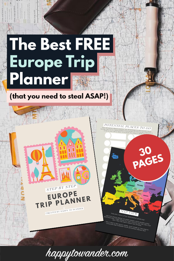
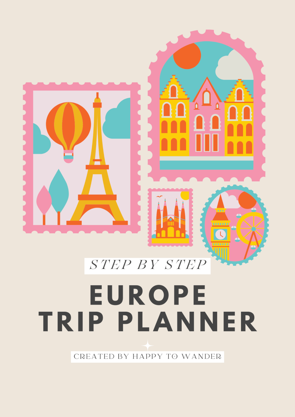
The FREE Europe Trip Planner You Need to Steal (Printable + Digital Workbook!)
Last Updated: April 21, 2023
*FYI - this post may contain affiliate links, which means we earn a commission at no extra cost to you if you purchase from them. Also, as an Amazon Associate I earn from qualifying purchases. Check out our Privacy Policy and Disclosure. for more info.
Planning a trip to Europe? Stressed out about all the things you need to get done?
Don’t worry – my free 30 page Europe trip planner / workbook is here to help.
If you want a free resource that will guide you through the Europe trip planning process from start to finish, then keep scrolling. I have exactly what you need!
Save this Free Europe Trip Planner for Later!
You’ll be very glad you did.
How to Use My Free Europe Trip Planning Workbook
While I think the workbook itself is fairly self-explanatory, I think you’ll get the most value out of it if you first watch the accompanying video guide here, or read the written version of the guide in my How to Plan a Trip to Europe (Step by Step) post.
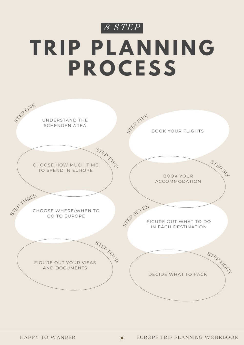
In short, the workbook contains 30 pages of helpful information and worksheets designed to guide you through the research and planning process for your Europe trip!
With it, you’ll go through all the following steps:
- Understanding the Schengen Area
- Choosing how much time to spend in Europe
- Choosing where/when to go to Europe
- Figuring out your visas/documents
- Booking your flights
- Booking your accommodation
- Figuring out what to do in each destination
- Deciding what to pack
Sound good? Then whoo – all my hours hunched over the computer were not in fact in vain. Take that, mom!
I’ve prepared two versions of this free Europe trip planner – a fillable PDF version that you can use and complete online, as well as a printable PDF version.
NOTE: There are some pages in the workbook that are intended to be used multiple times (e.g. one template/worksheet that can be used for every city or destination on your trip). In these cases, simply use your preferred PDF Reader to duplicate the pages as needed. This guide should help with that.
My Free Europe Trip Planning Workbook: Fillable PDF Version
This digital version is a fillable PDF with links to helpful resources and also interactive elements like checkboxes so you can have everything done online from your computer!
You can download it here.
My Free Europe Trip Planning Workbook: Printable Version
The printable version of my free Europe trip planner can be found here.
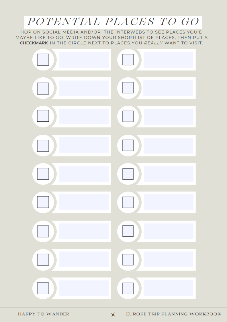
It’s basically the same as the digital copy, just with less emphasis on the clickable links and also a fun printable map that you can use to star your potential destinations.
NOTE: There are some pages in the workbook that are intended to be used multiple times (e.g. one template/worksheet that can be used for every city or destination on your trip). In these cases, simply print additional copies of those pages as needed.
I Hope You Enjoy Using My Free Europe Trip Planner!
Let me know in the comments if you have any questions or suggestions for additional pages to be added. I’d love to continue improving this free Eurotrip planner for the future, so I’m all ears!
My Go-To Travel Favourites:
🧳 Eagle Creek: My favourite packing cubes
💳 Wise: For FREE travel friendly credit cards
🍯 Airalo: My go-to eSIM
🏨 Booking.com: For searching hotels
📷 Sony A7IV: My (amazing) camera
✈️ Google Flights : For finding flight deals
🌎 WorldNomads: For travel insurance
🎉 GetYourGuide: For booking activities
1 thought on “The FREE Europe Trip Planner You Need to Steal (Printable + Digital Workbook!)”
Christina, what a wonderful resource! Thanks so much and glad to see you back.
Leave a Comment Cancel reply
By using this form you agree with the storage and handling of your data by this website. *
Useful Maps of Europe for Planning a Trip
Traveling around Europe is much easier if you have a good map. This will not only give you a good picture of the area but help you plan your trip. As you make decisions about destinations you want to see, you can mark them on the map then choose the best route to get from one place to another.
Of course, when you go on your trip, you might want to buy a good European road atlas . Carrying a paper map means you don't have to rely on your phone, which can (and will) let you down at times. Plan ahead and you're less likely to get lost so you can enjoy your trip.
Maps of Europe
Maps of Europe vary greatly. Many simply outline the countries, others are static so you can't zoom into a particular country, and others are just too small. Rather than fumble around with all of those, we have two really good options for you.
The first is MapMaker Interactive from National Geographic . It's designed as an educational tool, but it includes a good overall and topographical map of Europe without all the fluff.
Simply zoom into Europe and go deeper into any country you're interested in. When you're ready, the map can quickly be printed (use the "landscape" setting in the printer pop-up box) and it will reflect exactly what's on your screen.
A road trip through Europe is a great way to see everything on your own schedule. If you're planning this type of trip, the Michelin tire company has a great map on ViaMichelin . It covers the entire world, but it makes navigating the roads of Europe easier.
You can use the route planner to go from one location to another, have the program suggest the quickest route, or send you the way with the most things to discover. The maps are printable and work for traveling by bike or walking through town as well.
Keep in mind that Europe seems big, but it's actually smaller than the continental United States. Traveling from one major city to another will not take as much time as you think.
Maps of Italy
Many of Europe's countries are divided into regions. Italy, for example, has 20 regions including the one you hear most about, Tuscany.
Each region is unique. They often offer their own cuisine and sometimes you'll find different styles of architecture or various local customs. Traveling by region is a great way to really immerse yourself in a particular culture and compare one to another.
A map of the best-known Italian cities will also help you navigate the country and plan your trip. If you are traveling by train—an economical option in Europe—then you will also want an Italian rail map .
Maps of France
There are 18 distinct regions in France. Paris, for instance, is located in Ile-de-France and Bourgogne is the famous wine region we know as Burgundy in English.
France is smaller than the state of Texas, so traveling around is quite easy. A map of the country's cities will aid you in where to go and many are within a day's drive of Paris.
Now, if you're interested in catching all the wine regions that France is famous for, compare the other maps with this wine region map . It's a fantastic way to see a lot of the countryside while sampling great vin along the way.
Maps of Spain
Spain has just 17 regions, which are divided into 50 provinces. The capital of Madrid is in a region of the same name while Seville is found in Andalusia.
This is another great country for train travel. A map shows you that direct train routes are available between all the major cities. The network also extends into Portugal.
Spain and Portugal are also known for their wines. If you're interested in incorporating the wines of Rueda, Alentejo, or Jerez into your journey, the regional wine map will come in handy.
Maps of Germany
Brandenburg, Bavaria, Rheinland-Pfalz, and Saxony, these are just some of the states in Germany that you can include in your travels. The country is made up of 16 states in total, including Berlin and Hamburg, which are really more like city-states.
A map of the biggest German cities will aid your planning as well. Bavaria and the city of Munich are a popular destination but don't discount a visit to Dresden or Leipzig , either. These are wonderful hubs for architecture and art.
You will also find that within your European travels, the trains of Germany are among the best. They are clean, comfortable, and the fastest way to get around the country. All you need is a good map of the train routes to start planning.
Maps of the United Kingdom
First of all, remember that the United Kingdom is a country in and of itself. It includes England, Scotland, and Wales along with Northern Ireland, and they are not individual countries. Ireland, however, is a separate country .
With that bit of political trivia out of the way, let's talk maps. England is on an island with Scotland to its north and Northern Ireland is across the Irish Sea and North Channel, sharing an island with Ireland. Getting around from one place to another on either island is relatively easy, though renting a car is best.
You will need a good map of England in order to navigate to the most popular attractions. London and Canterbury are far to the south of York and Durham Castle, so plan your trip to get in what you want to see.
While in the western part of England, consider driving into Wales and take in the scenery and ancient sites there as well.
From northern England, you can head right into Scotland. As you can see from the map of Scotland , it's not far to Edinburgh and Glasgow. From there, you can head to the many islands and lochs scattered over the countryside.
Maps of Austria
While these other countries attract the most attention, a trip to Austria promises just as much adventure and culture. It is filled with mountains and close to other European countries you might like to visit as well.
If you travel by train nowhere else, take the train while in Austria . It is the best way to see the expansive vistas and breathtaking landscape of the Austrian Alps.
10 Questions to Ask Yourself Before You Plan Your UK Trip
Top Tips for Planning a European Cruise Vacation
Maps of Countries With Cruise Ports of Call
How to Travel From Barcelona to Bordeaux by Train, Bus, Car, and Plane
France Guide: Planning Your Trip
How to Travel From Florence to Paris by Train, Bus, Plane, and Car
The 17 Best Countries to Visit in Europe
How to Travel From London to Paris by Train, Bus, Plane, and Car
Traveling by Train in Europe: Where, Why, and How
Plan the Perfect Trip to Spain
Your Trip to Edinburgh: The Complete Guide
October in Europe: Weather, What to Pack, and What to See
Top French Wine Tours, Regions and Wine Routes
How to Get the Best Hotel Deals in Europe
How to Travel From Zurich to Paris by Train, Bus, Car, and Plane
France Travel Planner for Every Vacation

Navigate forward to interact with the calendar and select a date. Press the question mark key to get the keyboard shortcuts for changing dates.
Navigate backward to interact with the calendar and select a date. Press the question mark key to get the keyboard shortcuts for changing dates.
Europe Trip Planner
Top destinations in europe.

Top attractions in Europe

Other notable attractions

Explore nearby places
- Mazerolles-le-Salin
- Grandfontaine
- Roset-Fluans
- Ecole-Valentin
- Avanne-Aveney
- Saint-Loup-Nantouard
- Chatillon-le-Duc
All related maps of Europe
- Map of Europe
- Map of Burgille
- Map of Marnay
- Map of Recologne
- Map of Etrabonne
- Map of Hugier
- Map of Vitreux
- Map of Mazerolles-le-Salin
- Map of Moncley
- Map of Autoreille
- Map of Franois
- Map of Grandfontaine
- Map of Roset-Fluans
- Map of Malans
- Map of Ecole-Valentin
- Map of Osselle
- Map of Pesmes
- Map of Boussieres
- Map of Avanne-Aveney
- Map of Saint-Loup-Nantouard
- Map of Chatillon-le-Duc
- Map of Beure
- Map of Besancon
- Map of Moissey
- Map of Chatenois
- Map of Chalezeule
- Map of Morre
- Map of Montfaucon
- Map of Gray
Europe throughout the year
- Europe in January
- Europe in February
- Europe in March
- Europe in April
- Europe in May
- Europe in June
- Europe in July
- Europe in August
- Europe in September
- Europe in October
- Europe in November
- Europe in December
Q&A about Europe
Add places from guides with 1 click, collaborate with friends in real time, import flight and hotel reservations, expense tracking and splitting, checklists for anything, get personalized suggestions.
4.9 on App Store, 4.7 on Google Play
Map of Europe
Book your individual trip , stress-free with local travel experts
- roughguides.com
Interactive map

Empires were born in Europe . And even today, the continent’s influence extends far beyond its geographical boundaries, shown here in our map of Europe.
This is a place where dozens of languages and nations are stitched together by shared values – and even a shared parliament. But Europe remains tantalisingly diverse, and thanks to its relatively relaxed border controls, it’s super-easy to explore.
With just a short time in Europe, you’ll soak up history and culture by the bucket load. Castles and cathedrals are high up on many visitors’ wish lists, but Europe is also home to fantastical palaces, ancient ruins and extravagant galleries that are stacked with centuries-old art.
Away from the classic city-break destinations ( London , Rome and Paris could all eat up weeks of your time), options for exploring are almost limitless. Spot polar bears in Svalbard , embark on your own island odyssey in sunny Greece , or search for tranquillity – and distilleries – in the misty glens of rural Scotland .
The only real problem is choosing where to start. Use our Europe map to research and plan out your next Eurotrip or contact a local expert for help in booking your Tailor-made trip.

- Bosnia-Herzegovina
- Czech Republic

written by Eleanor Aldridge
updated 23.10.2020
Ready to discover tailor-made travel?
Get support from our local experts for stress-free planning & worry-free travels.

4 Free Full Detailed Printable Map of Europe with Cities In PDF
This Printable Map of Europe with Cities shows the second smallest continent of the world after Australia, yet the continent has some top developed countries in its bucket, including the Russia and United Kingdom. A map of the Europe continent with (Europe map cities) will help you in having an overview of its structure and the, geographical characteristics, and the political boundaries as well. The continent has a population of over 742 million people living in its 50 countries. The Europe map shows the geographical position of the continent along with the country boundaries. The Europe map is very helpful for those who are planning to travel to the continent as it will give them a clear idea about the different countries and their locations. The detailed free printable map of europe with cities is easy to download and is printable too. Now, you have the entire region of one of the world’s smallest continents in your hand. So use its amazing features to explore the area. The Printable Europe Map with Cities is All Free to download! Don’t forget, you can also take a look at the printable world map with countries.
Table of Contents
Printable Map of Europe with Cities Major European Cities List: Detailed Map of Europe with Cities Printable Europe Map with Cities and Countries Countries of Europe: Large Map of Europe with Cities and Towns
Printable Map of Europe with Cities

The map of Europe is used across the various domains for its own reason, such as you can use the Europe continent map to study the region of Europe. This map of Europe cities can be used in the educational domain in order to teach the students about the continent, or you can even use it if you are planning to visit the whole of Europe on your trip.
Major European Cities List:
- Paris, France : The City of Light is one of the most popular tourist destinations in the world. It’s also a major business centre and the home of fashion.
- London, England : The capital of the United Kingdom is a diverse and cosmopolitan city with a rich history. It’s also a major financial centre.
- Madrid, Spain : The capital of Spain is a vibrant and lively city with a rich culture. It’s also a major financial centre.
- Rome, Italy : The capital of Italy is a beautiful and historic city with a rich culture. It’s also a major business centre.
- Berlin, Germany : The capital of Germany is a modern and cosmopolitan city with a rich history. It’s also a major business centre.
- Vienna, Austria : The capital of Austria is a beautiful and historic city with the charm of old Vienna. It’s also a major business centre.
- Moscow, Russia: Moscow is the capital of Russia and one of its largest cities. It has a rich history and culture, and it’s one of the most important business centres in the country.
- St. Petersburg, Russia: St. Petersburg is the second-largest city in Russia and one of its most important tourist destinations. It has a rich history and culture.
- Istanbul, Turkey: Istanbul is the largest city in Turkey and one of its most important tourist destinations. It’s a cosmopolitan city with a rich history and culture.
- Athens, Greece: The capital of Greece is a beautiful and historic city with a rich culture. It’s also one of the most important business centres in the country.
- Budapest, Hungary: The capital of Hungary is a beautiful and historic city with a rich culture. It’s also one of the most important business centres in the country.
- Copenhagen, Denmark: The capital of Denmark is a beautiful and historic city with a rich culture. It’s also one of the most important business centres in the country.
- Brussels, Belgium: The capital of Belgium is a beautiful and historic city with a lot of cultures. It’s also one of the most important business centres in the country.
- Valetta, Malta: Valletta is the capital and largest city of Malta. It’s a historic town with a lot of cultures , and it has one of the busiest harbours in Europe.
- The Hague, Netherlands: The Hague is the largest city in the province of South Holland in the Netherlands. It’s a beautiful and historic city with a lot of cultures.
- Luxembourg City, Luxembourg: Luxembourg City is the capital of Luxembourg. It’s a small but cosmopolitan city with a lot of cultures.
- Zagreb, Croatia: The capital of Croatia is a beautiful and historic city with a lot of cultures. It’s also one of the most important business centres in the country.
- Prague, Czech Republic: The capital of the Czech Republic is a beautiful and historic city with a lot of cultures. It’s also one of the most important business centres in the country.
- Warsaw, Poland: The capital of Poland is a beautiful and historic city with a lot of cultures. It’s also one of the most important business centres in the country.
- Lisbon, Portugal: Lisbon is the capital and largest city of Portugal. It’s a beautiful and historic city with a lot of cultures, and it’s one of the busiest ports on the Atlantic coast.
- Dublin, Ireland: Dublin is the capital and largest city of Ireland. It’s a beautiful and historic city with a lot of cultures.
These are just some of the most popular tourist cities in Europe, but there are many other interesting cities that may not be as well known to tourists. No matter whatever may be the use of the Europe continent map, you will always make the most of it in various contexts. Here in this article, we are going to provide you with the full detailed printable map of Europe along with its cities.
Detailed Map of Europe with Cities

You can avail the printable map of Europe with cities from here and in this map we have kept our emphasis on the cities so that you can easily have the details of all the cities in all the aspects.
Printable Europe Map with Cities and Countries

A printable map is the most used map in the current digital scenario of the Internet, and there are many reasons behind it. The very first reason is the ease of use since you can easily use it on all your digital devices, such as smartphone devices or computers. The other major reason is that you can just easily get it from the Internet and save your efforts of designing it on your own.
Countries of Europe:
- France : The largest and most populous country in the continent of Europe is France. This beautiful and historic country has a lot of cultures, and it’s also one of the most important tourist destinations in the world.
- Germany : Germany is another popular country in Europe, known for its vibrant cities, rich culture, and history. It’s also one of the most important business centres in Europe and a popular tourist destination.
- Italy: Italy is one of the most famous countries in Europe, known for its fashion, art, culture, and cuisine. It’s also one of the major economic hubs on the continent, with many thriving industries located there.
- Spain: With its stunning beaches, vibrant cities, and rich culture, Spain is another popular country in Europe. It’s also one of the major tourist destinations on the continent, with millions of visitors each year.
- United Kingdom: The United Kingdom is a large country made up of England, Scotland, Wales, and Northern Ireland. It’s a popular tourist destination known for its historic landmarks, picturesque scenery, and lively cities.
- Czech Republic: The Czech Republic is a small country located in Central Europe. It’s known for its beautiful scenery, historic landmarks, and rich culture.
- Hungary: Hungary is a landlocked country located in Central Europe. It’s known for its beautiful scenery, historic landmarks, and rich culture.
- Portugal: Portugal is a coastal country located in the Iberian Peninsula. It’s known for its beautiful beaches, historic landmarks, and rich culture.
- Switzerland: Switzerland is a mountainous country located in Western Europe. It’s known for its stunning alpine scenery, historic castles, and thriving economy.
- Austria: Austria is a small landlocked country located in Central Europe with a rich culture and history. It’s also one of the major tourist destinations on the continent, with millions of visitors each year.
- Norway: Norway is a Nordic country located in Northern Europe. It’s known for its stunning scenery, vibrant cities, and rich culture.
- Finland: Finland is a Nordic country located in Northern Europe. It’s known for its beautiful landscapes, historic landmarks, and thriving economy.
- Sweden: Sweden is a Nordic country located in Northern Europe known for its stunning scenery, vibrant cities, and rich culture. It’s also one of the major tourist destinations on the continent, with millions of visitors each year.
- Denmark: Denmark is a Nordic country located in Northern Europe. It’s known for its beautiful scenery, historic landmarks, and thriving economy. It’s also one of the most popular destinations in Europe for tourists from across the world.
These are some of the most important countries which can help you to find out more about this continent as well as know more about its various aspects through these details. As above given details, it is easy to say that there are so many things which you will be able to do when you visit Europe, and this is the reason why it is one of the most popular tourist destinations in the world. So, if you are looking for a decent printable template of the Europe continent with its cities, then we are offering you that here. It has been designed in a formal format and can be used across any domain.
Large Map of Europe with Cities and Towns
Well, if you are someone who wants to study the continent of Europe in a thorough manner, such as the even the towns and the cities of Europe, then a large map of Europe will serve that purpose. A large european cities map will provide you with clear insight and a view of the whole continent, including even the small details so that you can get a satellite view of all its territory. We have designed one such large printable template of Europe in which you can study the whole continent of Europe in the best possible way. It has a very high-quality layout in which you can clearly observe even the political boundaries of the cities and towns. It is available in several formats such as PDF, Excel, Word, etc. hence you can get the one which suits you. Uses of Map of Europe with cities and towns: There are various purposes for which this map of Europe with its cities and towns can be used. Let us have a look at some of them:
- For travelling: If you are planning to visit Europe anytime soon, then this map will come in handy as it will provide you with a detailed view of all the countries, their boundaries, and their cities. This way, you can easily plan your trip and make sure that you don’t miss out on any important places.
- For students: This large map of Europe is also very useful for students who are studying this continent in their school or college. They can use this map to get a clear understanding of the whole continent and its various countries and their capitals.
- For researchers: This map is also very useful for various researchers who are studying the history of the European continent. From this map, they can easily get a clear view of the entire continent and its political boundaries so that they can conduct their research accordingly.
- For business: If you own a business or want to start one in Europe, then this map will be very helpful as it clearly shows all the countries and cities along with their capitals so that you know which country to establish your business in and what locations to target within those countries.
- For Geography: This map of European cities is also useful for people who are studying Geography as it provides a clear view of all the physical features of Europe, such as mountains, rivers , lakes, etc. This way, they can easily understand the geographical layout of the continent.
There are various other uses of this map as well, and you can use it according to your requirement. We have designed it in multiple formats so that you can get the one which suits your purpose. So, if you are looking for an informative printable template of Europe with its cities and towns, then we are here to help you out! We have designed multiple formats available in high quality so that you can get the one which suits your purpose.

You may also like

4 Free Labeled Map of Europe Rivers In PDF
4 Free Labeled Map Of Europe with Countries in PDF
Free Political Map of Europe with countries in PDF
Recent posts.
- Utah Railroad Map
- Printable Map of Utah
- Utah Outline Map
- Utah County Map
- Utah Rivers Map
- Backpacking Group Tours
- Flashpacking Group Tours
- Premium Group Tours
- All Group Tours
- Get a Quote
- Destinations
- Sustainability
- Gift Vouchers
- Educational Trips
Europe Trip Planner
Euroventure specialises in multi-city europe trips – specifically interrail and eurail adventures., check out our resources and tools below to help you plan your european escape.
It can be really overwhelming trying to plan your Europe trip. There are a ton of things to work out, research and eventually book. That’s why we offer as many resources and services as possible. From planning tools and rail trip advice, to fully guided tours , we can help you plan your ultimate Europe trip on your terms.
Use our interactive Europe Trip Planner tool to create your own route.
Use our Europe trip planner map to create your own self-guided route, including any major European destinations – plus some further afield including Russia and China!
The map tool is interactive and super easy to use; you can make a plan without any obligation to book your trip with us. We’ll then send you over our best ideas for your route, plus a price including all your trains and accommodation. If you like the idea of having your multi-destination trip planned for you, you can book it within minutes! If not, no problem – you can still use the planner.
Not sure which destinations to visit? Get some inspiration with our destination guide !
")
Planning a trip to Europe but need some inspiration? Take a look at our self-guided itineraries.
Choose the route you like the best, and we’ll plan your Europe trip. You travel on your own, or with friends, but we’ll organise everything and send it all to you in a handy travel pack. We can also book activities, attractions and excursions for you. All you have to arrange is a flight to and from your start/finish point, plus your travel insurance (which you can sort through our partners here ) and spending money. Find out roughly how much spending money to take .
Wherever we can, we use trains to get from A to B. They’re the most sustainable, sociable and convenient way to get around – and we’ve got deals with all the main providers plus a ton of expert knowledge! Read more about travelling Europe by train – or check out our comparison of different ways to travel Europe for more inspiration. Scroll down for Europe trip itineraries from 1 – 8 weeks or longer!
If you prefer to travel with likeminded backpackers, why not join one of our small group trips across Europe: Find out more.
WhatsApp us

Europe Map with Countries – Europe Map Political [PDF]
Check out our variations of a printable Europe map political or a Europe Map with countries ! You can download any political map of Europe for free as a PDF file. Print out as many copies as you need to teach or learn about the countries of the European continent! Of course, you can also use our maps for other personal or professional purposes.
We also offer other free continent maps and of course a blank map of Europe . So get your free maps now and also take a look at our fun and interactive Europe map worksheets !
- 1 Europe Political Map
- 2 Map of Europe with Countries
- 3 Cold War Map of Europe Political
- 4.1 Printable Europe Political Map
- 4.2 Europe Political Map Labeled
- 4.3 More Free Maps to Download and Print
- 4.4 Other Maps of Europe
- 4.5 European Country Maps
- 4.6 Other Country Maps
- 4.7 US State Maps
- 4.8 Continent Maps
Europe Political Map
The continent of Europe is not to be confused with the European Union. While the geographical region of Europe includes more than 40 countries, the EU only consists of 27 member states. The European Union is an economic and political union while Europe is a continent.
Our first political map of Europe includes only those countries that entirely belong to the continent. However, parts of Russia (until the Ural mountains) and Turkey (the region of East Thrace and a part of Istanbul) geographically belong to Europe as well.

Download as PDF
The map does not only show the countries of Europe, but also the European capitals as well as some of the major cities.
Map of Europe with Countries
Here is an alternative map of Europe printable showing today’s political divisions of the European continent. However, this map does not include any capitals or other cities, only the country names.
We also offer labeled and blank maps of all the other continents .
Download as PDF A4
Download as PDF A5
The map also shows the names of oceans and seas in Europe such as the Black Sea, the Mediterranean Sea or the Atlantic Ocean. Additionally, you might want to take a look at our physical map of Europe page.
Cold War Map of Europe Political
Until the fall of the Berlin Wall and the collapse of the Soviet Union, the map of political Europe looked quite different from today. As you can see in the map below, Germany was still divided into two separate states. At the same time, Yugoslavia, Czechoslovakia as well as the USSR still existed as cohesive countries. Today, there are all split up into several independent states.
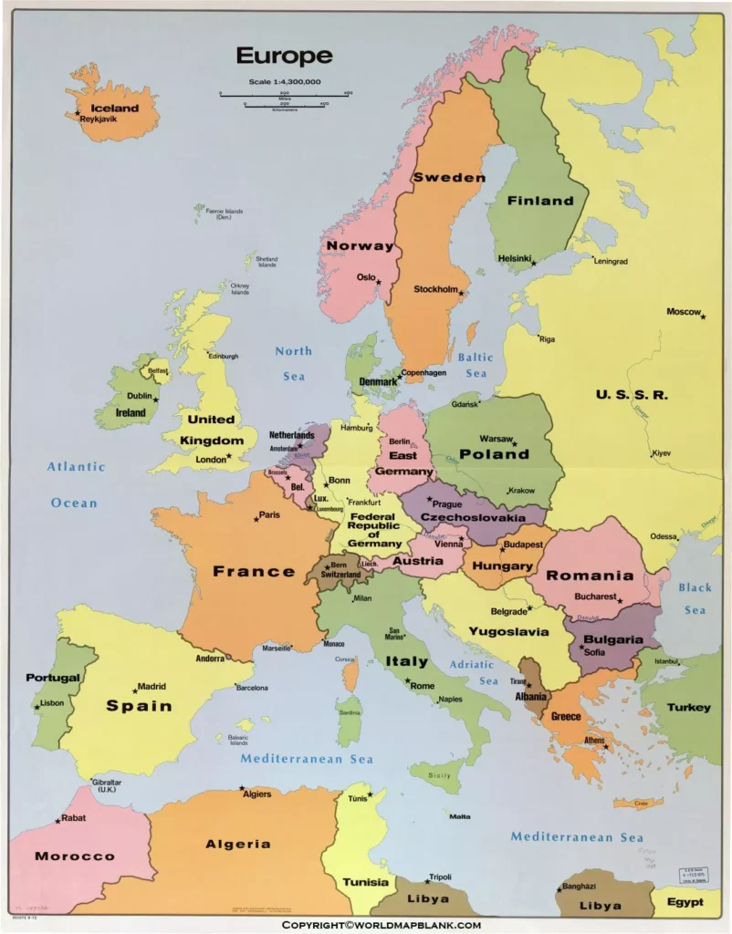
During the times of the Cold war Europe was divided into western Europe and eastern Europe approximately alongside the inner German border. Today, the United Nations suggest the following subdivision:
Northern Europe: UK, Ireland, Iceland, Norway, Sweden, Finland, Denmark, Estonia, Latvia, Lithuania
Southern Europe: Portugal, Spain, Italy , San Marino, Slovenia, Croatia, Bosnia and Herzegovina, Serbia, Kosovo, Albania, Montenegro, North Macedonia, Greece and the European part of Turkey
Eastern Europe: Poland, Czechia, Slovakia, Hungary, Romania, Belarus, Ukraine , Bulgaria , Moldova and the European part of Russia
Western Europe: France , the Netherlands , Belgium, Luxembourg, Germany , Austria, Switzerland and Liechtenstein
One could also argue that countries like Germany, Poland, Austria, Switzerland and others form a separate area of central Europe.
Political Map of Europe with Capitals
The next version below is a Europe map with countries and capitals. Just like the similar map further above, it includes Russia and Turkey into the continent, even if only parts of these countries are in Europe.

Apart from the printable Europe maps on this page, we also provide different variations of a labeled map of Europe . Also, you might want to enhance your teaching or learning experience with a blank map of Europe .
Printable Europe Political Map
The following map shows the European Union with its member states according to the year they became part of the union. In 2022, also the Ukraine was granted EU candidate status as a reaction to the Russian military attack on the country.
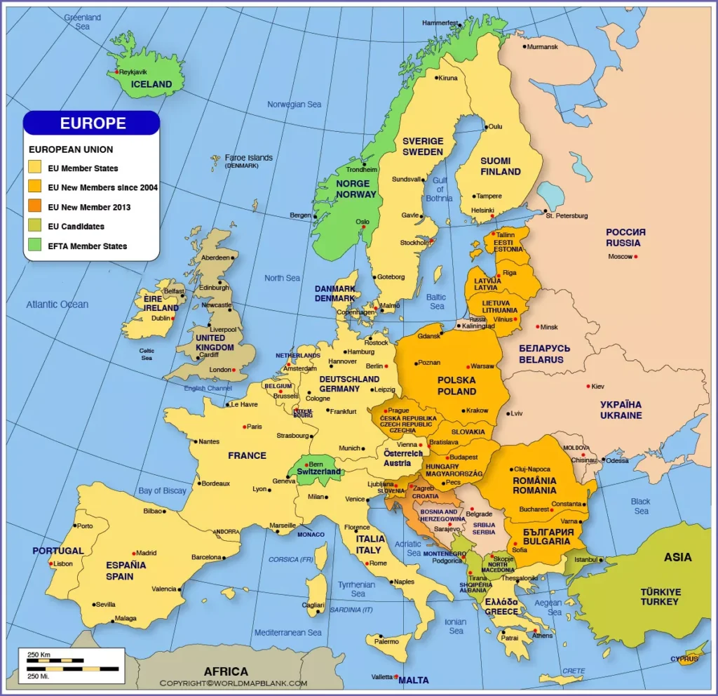
At the time of writing, the European Union consists of 27 member states. Its history can be traced back to 1957, when Belgium, France, Italy , Luxembourg, the Netherlands and the Federal Republic of Germany founded the European Economic Community. The goal was to promote the European integration by a common economic policy.
Europe Political Map Labeled
The European continent stretches from the Atlantic Ocean via the British Isles in the west and north-west to the North Sea and the Baltic Sea in the north and then all the way down to the Black Sea and the Caucasus Mountains in the east – not to forget the Mediterranean Sea in the south.
Among the largest European cities are Istanbul, London, Moscow, Saint Petersburg, Madrid, Berlin, Kyiv, Paris, Rome and Bucharest. Dowload below another Europe map PDF.
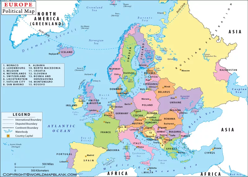
Here is a list of all the European countries and capital cities:
- Andorra – Andorra la vella
- Austria – Vienna
- Belarus – Minsk
- Belgium – Brussels
- Bosnia and Herzegovina – Sarajevo
- Bulgaria – Sofia
- Croatia – Zagreb
- Czechia – Prague
- Denmark – Copenhagen
- England – London
- Estonia – Tallinn
- Finland – Helsinki
- France – Paris
- Germany – Berlin
- Greece – Athens
- Hungary – Budapest
- Iceland – Reykjavík
- Ireland – Dublin
- Italy – Rome
- Kosovo – Pristina
- Latvia – Riga
- Liechtenstein – Vaduz
- Lithuania – Vilnius
- Luxembourg – Luxembourg
- Moldova – Chișinău
- Montenegro – Podgorica
- Netherlands – Amsterdam
- North Macedonia – Skopje
- Northern Ireland – Belfast
- Norway – Oslo
- Poland – Warsaw
- Portugal – Lisbon
- Romania – Bucharest
- Russia – Moscow
- San Marino – San Marino
- Scotland – Edinburgh
- Serbia – Belgrade
- Slovakia – Bratislava
- Slovenia – Ljubljana
- Spain – Madrid
- Sweden – Stockholm
- Switzerland – Bern
- Turkey – Ankara
- Ukraine – Kyiv
- Wales – Cardiff
More Free Maps to Download and Print
Have you found the political Europe map you were looking for? If not, maybe you will find a convenient map of Europe or any other map you might need via the link selection below. You can also use our search bar at the top of the page to find more maps of the world, its continents and many countries.
We offer physical, blank and political maps but also river and mountain maps of different regions of the world. You can download them all as PDF files and print them out as often as you like.
Other Maps of Europe
Labeled Map of Europe
Blank Map of Europe
Physical Map of Europe
Map of European Rivers
European Country Maps
Map of Germany with States and Cities
Blank Map of Germany
Italy Map with Regions
Blank Map of Italy
Map of France with Regions
Blank Map of France
Bulgaria Map Blank
Austria Map Blank
Map of Austria with States
Map of Sweden with States and Cities
Blank Map of the UK
Other Country Maps
Blank Map of the USA
United States Map with States
Canada Provinces Map
Blank Map of Canada
New Zealand Blank Map
Australia Map Labeled
Blank Map of Australia
US State Maps
Labeled Map of California
Blank Map of Florida
Map of Illinois
Blank Map of Wisconsin
Labeled Map of Minnesota
Blank Map of Arizona
Continent Maps
Labeled Map of Africa with Countries
Map of South America with Countries
Blank Map of South America
Political Map of Asia
Blank Map of Asia
New and Updated Maps

Printable Blank Map of Indonesia- Outline, Transparent, PNG Map
Printable Blank Map of Israel – Outline, Transparent PNG Map
Printable Blank Map of Iraq – Outline, Transparent, PNG map
Printable Blank Map of Zimbabwe – Outline, Transparent, PNG map
Printable Blank Map of Jamaica – Outline, Transparent, PNG map
Printable Blank Map of Zambia – Outline, Transparent, PNG map
Printable Blank Map of Vanuatu – Outline, Transparent, PNG Map
Printable Blank Map of Venezuela – Outline, Transparent, PNG Map

Printable Blank Map of Tajikistan – Outline, Transparent, PNG map
Printable Blank Map of Uganda – Outline, Transparent, PNG Map
Filter by category.
We participate in the Amazon Associates Program and other affiliate programs. This means that some of the links on this website are affiliate links. When you click on them and make a purchase, we will earn an affiliate commission at zero cost for you.
- Skip to main content
- Skip to secondary menu
- Skip to primary sidebar
World Map Wizard
5+ Printable Full Detailed Map of Europe With Cities [PDF]
August 7, 2023 by Susan Leave a Comment
Are you struggling to explore the European countries and their cities’ geographical and infrastructure structure in one place? If yes then our Map of Europe With Cities format is definitely for you. With this map, enthusiasts can explore every country of Europe their cities or towns all in one place.
The map comes in the easy to Easy-To-Printable Format for the convenience of the scholars and can also be shared with others. So feel free to print the map from here and make the most of it in your learning process of European geography.
- Exploring Blank Map of Brazil
- Printable Blank World Map
- Blank World Map With Continents
- Printable Labeled Map of Asia
- Blank Map of Japan
- World Map with Coordinates
- Printable India Map With States
- Printable Blank World Map For Kids
- Printable World Map With Countries
Map of Europe With Cities
Map of europe with cities printable.
Europe is known for its spectacular and modern infrastructure of the cities across the different countries. All these cities are large in numbers and going through all of them at once can be a challenging task. For the same reason, we have come up with our dedicated map of Europe here that would assist all our geographical enthusiasts here.

Using this map, enthusiasts can check out or explore the extensive geography of European cities in one single place. It includes all the cities of the continent from A to Z with their respective names for the convenience of enthusiasts. They can thus smoothly find any concerned town from the map and then get into its geography. The map brings both the physical and the political geography of the continent in the smoothest manner possible.
Detailed Map of Europe with Cities
Going with the geography of European cities at once can certainly be a hectic task for most of us. There are nearly 51 countries in Europe and all of them comprise significant numbers of cities. All these cities come with a significant base of physical and political geography and other components.

We have developed this map here to make the geographical learning of European cities come easier for all enthusiasts. Using this map one can get into the in-depth geography of every European city. This map contains comprehensive coverage of all the European cities in a well-detailed manner. Enthusiasts can thus use the map to explore every detail of the cities in one place.
The map of Europe with the cities is one of the most demanded maps among all those who want to explore European cities. With this map, enthusiasts can get to know European cities from a close dimension. They can explore the cities’ beautiful landscapes and spectacular infrastructure. European cities are always the center of attraction across the world and from the tourist perspective as well.

Each year more and more tourists plan to explore European cities. With this dedicated map, we aim to help all our tourists and Alps geographical enthusiasts get through all the European cities. One can also use this map in academic usage as well smoothly in the day to day life.
Printable Europe Map with Cities and Countries
Going through the geography of European cities and countries at the same time can prove to be a hectic task for most of us. Europe is home to some of the world’s best countries and cities that are globally known. We have compiled the comprehensive geography of all the European cities and countries in one place for the convenience of our readers.

They can use this map to go through all the cities of the continent smoothly without even needing any external support. The map offers a broad range of geographical aspects of the continent. It includes the physical landscape and all other infrastructure of the countries and the cities lying on the continent.
Large Map of Europe with Cities and Towns
The large map of Europe is known as the ideal source for exploring the comprehensive geography of European cities and towns. This map comes with the dedicated geography of all the towns and cities of Europe in one place. The map is thus ideal for anyone who wishes to go through the whole geographical component of Europe.

It will help all academic scholars and other enthusiasts to know this continent from a close dimension. The map comes in the free printable format which makes it easier for the users to use it smoothly. They can also share the map with other aspiring scholars and enthusiasts of the continent.
Map of Eastern Europe with Major Cities
Do you want to explore the eastern region of Europe in the smoothest way possible? If yes, feel free to look at our Eastern map of the European continent here. In this map, you shall witness the whole eastern region of Europe in one place including the major cities.

Consequently, you can use this map to explore the whole geography of Eastern Europe in the smoothest manner possible. The map is easier to use and can also be shared with others without any difficulty as such. Feel free to print the map in the digital pdf format or also in the traditional style as per your learning convenience.
Reader Interactions
Leave a reply cancel reply.
Your email address will not be published. Required fields are marked *
Save my name, email, and website in this browser for the next time I comment.
- Europe Map Print Out - Labeled
- Share Print Out

Labeled map of Europe great for studying geography. Available in PDF format.
1 MB | 4,432 Downloads
More Print Outs
All Print Outs

Europe Map Quiz Print Out

Central America Map Print Out - Blank

Canada Map Print Out - Labeled

Canada Map Quiz Print Out - Key
- Australia: States and Territories
- Canada: Provinces and Territories
- South America
- United States of America
Map Quizzes
- 50 US States Map Quiz
- 50 US State Capitals Map Quiz
- Canadian Provinces and Territories Map Quiz Game
- Central America Map Quiz
- South Amnerica Map Quiz
- 50 US States Flashcards
- 50 US State Capitals Flashcards
- 50 US State Flags Flashcards
- European Countries Flashcards
- World Continents Flashcards
- United States Map Print Out - Blank
- United States Map Print Out - Labeled
- United States Map Quiz Print Out
- United States Map Quiz Print Out - Key
Share this Print Out

Free Study Maps is a free resource and relies on great people like you to help keep it running. All donations are greatly appreciated and keep new content coming.
Donate Today!
My itinerary
This is a free demo version of our mapping software.
Create an account to save your current itinerary and get access to all our features.
Otherwise your data will be automatically deleted after one week.
- Skip to main content
- Skip to secondary menu
- Skip to primary sidebar
World Map with Countries
Full Detailed Map of Europe With Cities in PDF & Printable
June 11, 2022 by Paul Smith Leave a Comment
Map of Europe With Cities: All of us have a dream to at least visit a foreign country and those who think so must also have some knowledge of some famous countries, as we residing in India for us some of the mega countries are the United States, Britain, France and many more. One of those countries in Europe, the second smallest continent of the world, and today we are going to brief you guys about some of the great things here.
In school, we have to interact with the world map but initially, it is very difficult for the students to settle and learn how to use the map. And similar to every country, Europe also has its map and if you are looking for such maps then you have landed in the right place. We are bringing our Map of Europe With Cities along with all the cities and the best thing is that it will also be available in printable form.
Map of Europe with Cities Printable

Detailed Map of Europe with Cities
The users who are interested in knowing more details regarding the country- Europe can take the help of our map as we will include all the cities that lie under such country and also we have tried our best that the users can get some major details of every city so the users can know that what are the famous things and where they can go to visit. Those who are planning to travel to a country like Europe, they must know some advantage things and if they get to know such information in advance, they can plan according to it.

Map of Europe With Cities
Here we will share all the information in detail and the users can get a lot of information through our maps. Our maps will be available for all the people and it will help those people who are fond of collecting information about various countries, they can get every small detail that will help them to achieve their goals.

Printable Europe Map with Cities and Countries
As we have already been informed that it is the second continent , so many people don’t recognize such countries but here the users will get all the small to small detail. What we always search for and heard is the country name but if we ask any individual to name some of the cities that lie in that country then they would not know the answer, so those users who want to learn how to locate cities on the map of Europe, they can refer to our new Map of Europe along with all the cities.

To make it convenient we are bringing the map in printable form, it will help those individuals who are going on holiday as they can carry the printed form of the map along with them, and wherever needed they can look and find the places where they want to visit.
Large Map of Europe with Cities and Towns
This map is for those users who are in schools and colleges as this map can be a stick in the wall and can also be hung. The size of the maps is editable and the users can make changes according to their preference and when needed they can take out the large size of the map of Europe .

The large map will contain all the cities and towns whether small or big will be inside the map. The map is customized in such a form that the users can carry the map along with them as it can be folded and can also fit in a small space. The users will find certain comparisons in which they will find certain things which this country has and others don’t.
Map of Eastern Europe with Major Cities
Countries like Russia, Poland, Croatia, and many more are close to Eastern Europe. And here we will cover all the towns and major cities which fall in this region, the quality of the Map of Europe With Cities will be available free of cost and no charges will be needed to use the maps.
The maps are also available in hardcopy form and the users just have to do is that they can download the maps and can store them on their storage devices such as smartphones and laptops whenever they needed them they can go to any printing shop and can get a copy of the maps .

Reader Interactions
Leave a reply cancel reply.
Your email address will not be published. Required fields are marked *
Save my name, email, and website in this browser for the next time I comment.
Sale! Sale! Sale! Up to 60% off !
Professionally designed printables available in multiple sizes and colors. All files immediately accessible once purchased, and ready to print as is.

Europe Travel Map Journal
Sale price $2.30 Regular price $7.00
- Description
- Digital Downloads Instructions
Printable Europe Travel Map Journal PDF
Journey across Europe with our Europe Map template, ideal for both detailed route planning and a checklist of countries to visit. It's a must-have for travelers and geography buffs.
Size of this European Journey Log
You get this Europe Travel Map Journal in an A5 Format. Please note that there are ways in which you can print the file at other sizes, however quality is due to vary depending on which size you print at.
Styles of this Europe Trip Tracker
You will get two different variations of this Europe Travel Map Journal with your purchase. Choose your favourite or use both! If I have made any custom changes on customer requests, I will also include these variations with your purchase.
Colors of this Traveling in Europe Diary
Upon purchasing, you get this European Countries Visited Log in 20 colors. Choose your favorite, or mix, match and color code your planner to suit your own personal preferences. It should be noted that when printed, some of these colors are very similar and may be indistinguishable. All colors are included so that customers who have purchased from either my original range or extended range will be able to match their current styles.
Colors included:
- Original 8: Red, Orange, Yellow, Green, Blue, Pink, Purple, Grey)
- Extended Range (12): Salmon Red , Light Orange, Bright Yellow, Light Green, Teal, Light Blue, Aqua, Light Purple, Lavendar, Light Pink, Light Brown, Light Grey,
Product Disclaimers
- Instant digital download (nothing will be shipped).
- You are given .pdf file(s). These files are NOT EDITABLE, and are made to be printed as is.
- Printables on this site are for personal use only. You may not alter, redistribute, or resell them for monetary
All products in this store are digital; no physical products will be shipped.
Printables on this site are for personal use only . You may not alter, redistribute, or resell them for monetary gain. You can read the full set of terms and conditions here.
Due to the range of technology now available, we are unable to provide any technical help at this time.
If you are having any trouble, please do not hesitate to reach out either through my shops form or via my email. I can email files at any point!
File Format
Most of our products are delivered to you in a ZIP file. Within this zipped file, your printables will be in .PDF format. The PDF files you receive will be non-editable, and are designed to be printed as is.
A PDF viewer is required to open, view and print the items. Most computers today come pre-loaded with Adobe Reader. If your computer does not have it installed, you can download it here for free.
It is recommended that you purchase on a computer (windows/mac), rather than a mobile device or tablet. Most mobile devices such as phones and ipads, do not allow for downloading through a link.
Unzipping a compressed file
On a laptop or PC - Save the folder to your computer. Double clicking the compressed file will work in most situations. If not, right-click and select, "Extract All. If you would then like the files on. your mobile device, you can add them to iCloud or Dropbox. Sometimes, apps on your browser may affect the download process. If this occurs, please try using a different browser.
On a mobile device – Most mobile devices will require a special app to extract the files from a compressed folder. For this reason we suggest against using these devices. If you require an app, we recommend "File explorer Free to unzip the compressed file. Using the file explorer app, you can extract the files and save onto your mobile device. Some mobile devices allow you to long press the zipped file icon and then click "Extract." without downloading a special app first.
If you can't find the file once it's downloaded , try looking in Downloads under my Computer or search the title of the file on your computer for where it could be hiding.
Customer Reviews
- Choosing a selection results in a full page refresh.
- Press the space key then arrow keys to make a selection.

Get our Rail Planner app
Plan your trip, get extra discounts, and show your Pass as you go.

Our favorite spring routes
Celebrate spring with these 7 off-the-beaten-path train routes

All about seat reservations
Everything you need to know about booking your seats

Alternatives to Busy Routes
Travel between popular European cities without seat reservations

Through our Chatbot in the bottom right corner.

Ask the Community
Browse questions from fellow Eurail travellers, or ask your own!
- Plan your trip
European Railway Map
- Order overview
- Reservations overview
- My Trips & Travelers
- {{translatedTraveler}} {{#promotional}} {{currencySign}} {{standardPrice}} {{/promotional}} {{quantity}}x {{currencySign}} {{finalPrice}}
- Child {{childPasses}}x FREE
- {{translatedPassType}}
- {{translatedValidityPeriodDescription}}
- {{translatedClass}}
- Remove Pass(es)
- {{variant.localizedTravelPackDescription}} {{quantity}}x Free
- {{variant.localizedPassUpgradeDescription}} {{quantity}}x {{currency}} {{price}}
- Your order will arrive by {{expectedDeliveryDate}} 1 x {{currency}} {{price}}
Your cart is empty
Your Eurail travel map
Start planning your Eurail adventure here. You can see the average train travel times between all the big European cities in 33 countries on the train map below.
Train routes through 33 countries
The map below shows the bigger cities in Europe, to which cities they are connected and how long it takes to travel between them. It's an interactive map, so start clicking around and planning your trip!
Click on the train icons to see the cities of each country, and click on the routes (the lines in between 2 train icons) to see travel times. The green lines represent trains; the blue lines are ferries.
Please note that routes may change throughout the year. This map doesn’t show any (temporary) disruptions on the rail network; find more information on disruptions here .
Don't know where to start? Use our Trip Planner to find the best Eurail Pass for you!
Traveling with a eurail pass.
With a Eurail Pass you can travel in all countries on the Europe rail map above, now including Great Britain. Please note that most high-speed trains and all night trains need an advance reservation . These are not included in your Eurail Pass. We can help you book your seat reservations for 95% of the trains in Europe.
Travel times for 10 most popular routes
Check out the travel times between Europe's most popular cities. If you'd like to know more about a specific route, just visit our Popular Routes section .
Feel free to also play around with the Europe travel map above to see where else you could go with your Eurail Pass!
European itineraries
The Eurail railway map is a great resource for planning the perfect itinerary. Check out some examples of spectacular European itineraries you can experience with a Eurail Pass.
Follow one or more of our itineraries, or use parts of them to create your own. Planning your trip is half the fun, and with these itineraries, you get to see the very best of Europe!
Choose the right Pass
Not sure which Eurail Pass meets your travel desires?
Not to worry! Our Trip Planner will help you find the perfect Pass for your trip!
Change of currency
You cannot change the currency once you have a Pass in your cart. Remove the Pass, and then change the currency on the website header.

Effective Europe train travel planning with Eurail & Interrail map
Europe Train Passes Eurail & Interrail Map
If you are pondering over getting a Eurail or Interrail Pass for your next European adventure, you owe it to yourself to make sure that the pass is just the right fit for you. The first step to getting the maximum value out of your pass includes a bit of planning. And trust us, planning is half the fun of any trip. And that’s where a Eurail & Interrail map comes handy. As much as we would love to play detective, bring out our magnifying glasses and survey a big sheet of map, we’ve got something better for you - an interactive Eurail and Interrail map that is easy to understand and use.
Plan your journey with Eurail & Interrail map
This Eurail & Interrail map has all the big city train connections in Europe. Play around with the map and figure out the routes you intend to take and learn about the average travel time. Make a rough cost estimation of point-to-point tickets and compare it to the Eurail or Interrail Pass price, to identify if the pass is ideal for you.
However, do keep in mind that it's not just cost-savings that make the Eurail & Interrail Pass so popular but also the immense flexibility it lends to your travel plans. As opposed to the rigidity of point-to-point tickets, with the Eurail or Interrail Pass, you can simply turn up at the station and decide to take the next train that comes along. Additionally, planning the routes beforehand will also help you choose the most apt Eurail or Interrail Pass. Dive deep and find your primary travel routes below.
How to read the Eurail & Interrail Map?
- All the bigger European cities and train connections between them are mapped above. Keep in mind that Eurail or Interrail Pass is not limited to these train journeys.
- Click on the station icons to see the city name.
- Click on the lines connecting the cities to find the average train travel time between them
Frequently asked questions
Can i use the eurail or interrail pass in all european countries.
Eurail and Interrail Pass can be used in 33 European countries . To explore a single country, choose a single country pass and if you plan to go country-hopping, choose a Eurail or Interrail Global Pass.
What is the difference between Eurail and Interrail Pass?
The only difference between Eurail and Interrail Pass is the kind of travelers it targets. Eurail Pass can be used only by non-European residents, whereas Interrail Pass is for the specific use of European residents.
Can I customize my route based on my preferred destinations with Eurail or Interrail Pass?
The best thing about Eurail & Interrail Pass is that it is totally customizable. Decide the routes you intend to take using our interactive Eurail & Interrail map and simply add those journeys to your pass and get going!
How do I check train schedules and plan my itinerary accordingly?
You can find the train schedules on the Rail Planner App and select journeys as per your requirement. If you want to know the average duration of the journeys connecting main European cities, click on the lines connecting the two cities on the Eurail & Interrail map.
What are some tips for maximizing the use of my Eurail or Interrail Pass?
Planning ahead and choosing the right pass is the first step to maximizing the value of your Eurail or Interrail Pass. The main premise of the Eurail or Interrail Pass is that the more train travel you embark on, the more value you make of it.
Are there any scenic Eurail or Interrail routes that I should consider?
Europe teems with scenic train routes and many people often embark on train journeys just for the view. Bernina Express, Glacier Express and the Golden Pass Scenic Train in Switzerland, Rhine Valley Line in Germany, Flam Railway in Norway are just a few of our recommendations.
What are some popular Eurail or Interrail routes?
Rome to Florence, Paris to Rome, Madrid to Barcelona, Vienna to Budapest are a few popular routes covered by a Eurail or Interrail Pass.

Maria Philip
Every friend's gang has that one friend who plans the trip, finds cute little spots to explore great views and food, and keeps cool trivia handy. I am that friend. I like to know before I go, keep things under budget, and help others do the same through my writing. Someone once said, ‘Traveling makes you a storyteller’ and it stuck with me to do more traveling and telling. You will find me the happiest in quiet spots under thick green canopies, over a delicious spread of my comfort foods, or while loudly singing my favorite tunes, or engaging in silly banter with friends and family, or on the window seat of a moving bus or train with music plugged in. The list is longer, but you get the gist!
Be a smart traveler
The first to know about trending destinations, travel deals, tips and all things travel.
Maps of the April 2024 Total Solar Eclipse
By Jonathan Corum
On April 8, the moon will slip between the Earth and the sun, casting a shadow across a swath of North America: a total solar eclipse.
By cosmic coincidence, the moon and the sun appear roughly the same size in the sky. When the moon blocks the glare of the sun, the sun’s outer atmosphere, or corona, will be briefly visible.
Below are several maps of the eclipse’s path as well as images of what you might experience during the event.
Where Can I See the Total Eclipse?
The eclipse will begin at sunrise over the Pacific Ocean, then cut through Mexico and cross the United States from Texas to Maine. Most of North America will see a partial eclipse, but viewers within the deepest shadow — a band sliding from Mazatlán, Mexico, to the Newfoundland coast near Gander, Canada — will experience a total solar eclipse.
Percentage of
the sun obscured
during the eclipse
Indianapolis
Little Rock
San Antonio
Viewers inside the path of the total eclipse may notice a drop in temperature , a lull or shift in the wind , the appearance of bright planets in the sky, and the quieting of birds and other wildlife.
Many cities lie inside the path of the total eclipse, as shown below, the width of which varies from 108 miles to 122 miles.
5:13 p.m. NDT
20% partial eclipse
NEWFOUNDLAND
SASKATCHEWAN
Fredericton
4:33 p.m. ADT
3:26 p.m. EDT
3:20 p.m. EDT
Minneapolis
3:18 p.m. EDT
3:13 p.m. EDT
San Francisco
90% partial eclipse
3:05 p.m. EDT
Los Angeles
1:51 p.m. CDT
1:40 p.m. CDT
1:33 p.m. CDT
12:16 p.m. CST
12:12 p.m. CST
11:07 a.m. MST
Mexico City
EL SALVADOR
12:23 p.m. CST
1:36 p.m. CDT
3:09 p.m. EDT
3:27 p.m. EDT
Explore our interactive cloud outlook for eclipse viewing times and average cloud data at your location.
What Will I See?

A composite image of the 2017 solar eclipse over Madras, Ore.
Aubrey Gemignani/NASA
If the sky is clear, viewers in the path of the total eclipse should see a “diamond ring” effect a few seconds before and after the total eclipse, as the edge of the sun slips in and out of view.

The “diamond ring” effect during the 2017 solar eclipse.
Rami Daud/NASA, Alcyon Technical Services
The sun’s outer atmosphere, or corona, is normally hidden by the sun’s glare. These tendrils and sheets of gas, heated to a million degrees Fahrenheit or more, are in constant motion and shaped by the sun’s swirling magnetic field.

The sun’s corona during the 2017 solar eclipse.
The sun is relatively active this year and is nearing the expected peak of its 11-year solar cycle . Researchers at Predictive Science are using data about the sun’s magnetic field to predict and model a dramatic corona for the April eclipse.

A prediction of how the sun’s corona might appear during the April 8 total eclipse.
Predictive Science
What Colors Should I Wear?
As the sky darkens, light-sensitive cells in human eyes become more sensitive to blue and green hues than to reds and oranges. This shift in color perception is known as the Purkinje effect , after a 19th-century Czech scientist, and is typically seen at twilight.

Watching the 2017 total eclipse at Southern Illinois University.
Andrea Morales for The New York Times
To take advantage of the Purkinje effect, Solar Eyeglasses suggests wearing green clothes or a contrasting combination of greens and reds. Blue-green colors (shorter wavelengths) will appear brighter, while red colors (longer wavelengths) will appear to recede into the darkness.
What If I Miss It?
The next two total solar eclipses in the United States won’t occur until 2044 and 2045 . But eclipse chasers might catch one in 2026 in Greenland, Iceland and Spain; 2027 along the coast of Northern Africa; 2028 in Australia and New Zealand; or 2030 across Southern Africa and Australia.

A Total Solar Eclipse Is Coming. Here’s What You Need to Know.
These are answers to common questions about the April 8 eclipse, and we’re offering you a place to pose more of them.
By Katrina Miller

What’s the Cloud Forecast for Eclipse Day? See if the Weather Is on Your Side.
April 8 could be your best opportunity to see a total solar eclipse for decades. But if clouds fill the sky, you may miss the spectacle.
By Josh Katz, K.K. Rebecca Lai and William B. Davis
- Share full article
Advertisement

Solar eclipse 2024: Photos from the path of totality and elsewhere in the U.S.
Images show the Great American Eclipse, seen by tens of millions of people in parts of Mexico, 15 U.S. states and eastern Canada for the first time since 2017.
Millions gathered across North America on Monday to bask in the glory of the Great American Eclipse — the moment when the moon passes between the Earth and the sun.
The path of totality measures more than 100 miles wide and will first be visible on Mexico’s Pacific coast before moving northeast through Texas, Oklahoma, Arkansas, Missouri, Illinois and upward toward New York, New Hampshire and Maine, then on to Canada.
Total solar eclipse 2024 highlights: Live coverage, videos and more
During the cosmic spectacle, the moon’s movements will temporarily block the sun’s light, creating minutes of darkness, and will make the sun's outer atmosphere, or the corona, visible as a glowing halo.
Here are moments of the celestial activities across the country:

Breaking News Reporter
Elise Wrabetz is a Senior Photo Editor for NBC News digital
Chelsea Stahl is the art director for NBC News Digital
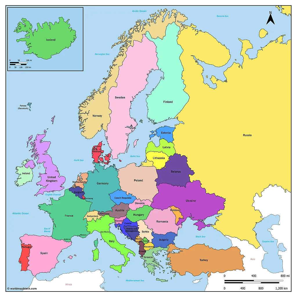
Map of Europe with countries and capitals

You may download, print or use the above map for educational, personal and non-commercial purposes. Attribution is required. For any website, blog, scientific research or e-book, you must place a hyperlink (to this page) with an attribution next to the image used.
- North America Map
- South America Map
- Oceania Map
Popular maps
- New York City Map
- Los Angeles Map
- Las Vegas Map
- Australia Map
- Germany Map
- Netherlands Map
- Singapore Map
- United Arab Emirates Map
- United Kingdom Map
- United States Map
U.S. States
- Arizona Map
- California Map
- Colorado Map
- Florida Map
- Georgia Map
- Illinois Map
- Indiana Map
- Michigan Map
- New Jersey Map
- New York Map
- North Carolina Map
- Virginia Map
- Wisconsin Map
Watch CBS News
Solar eclipse maps show 2024 totality path, peak times and how much of the eclipse people could see across the U.S.
By Aliza Chasan
Updated on: April 9, 2024 / 5:00 AM EDT / CBS News
A total solar eclipse crossed North America Monday with parts of 15 U.S. states within the path of totality. Maps show where and when astronomy fans could see the big event as skies darkened in the middle of the day Monday, April 8.
The total eclipse first appeared along Mexico's Pacific Coast at around 11:07 a.m. PDT, then traveled across a swath of the U.S., from Texas to Maine, and into Canada.
About 31.6 million people live in the path of totality , the area where the moon fully blocked out the sun , according to NASA. The path ranged between 108 and 122 miles wide. An additional 150 million people live within 200 miles of the path of totality.
Solar eclipse path of totality map for 2024

The total solar eclipse started over the Pacific Ocean, and the first location in continental North America that experienced totality was Mexico's Pacific Coast, around 11:07 a.m. PDT, according to NASA. From there, the path continued into Texas, crossing more than a dozen states before the eclipse enters Canada in southern Ontario. The eclipse exited continental North America at around 5:16 p.m. NDT from Newfoundland, Canada.
The path of totality included portions of the following states:
- Pennsylvania
- New Hampshire
Small parts of Tennessee and Michigan also experienced the total solar eclipse.
Several major cities across the U.S. were included in the eclipse's path of totality, while many others saw a partial eclipse. These were some of the best major cities for eclipse viewing — though the weather was a factor :
- San Antonio, Texas (partially under the path)
- Austin, Texas
- Waco, Texas
- Dallas, Texas
- Little Rock, Arkansas
- Indianapolis, Indiana
- Dayton, Ohio
- Cleveland, Ohio
- Buffalo, New York
- Rochester, New York
- Syracuse, New York
- Burlington, Vermont
Map of when the solar eclipse reached totality across its path
The eclipse began in the U.S. as a partial eclipse beginning at 12:06 p.m. CDT near Eagle Pass, Texas, before progressing to totality by about 1:27 p.m. CDT and then moving along its path to the northeast over the following few hours.

NASA shared times for several cities in the path of totality across the U.S. People could have also checked their ZIP code on NASA's map to see when the eclipse was to reach them if they were on, or near, the path of totality — or if they saw a partial eclipse instead.
How much of the eclipse did people see if they live outside the totality path?
While the April 8 eclipse covered a wide swath of the U.S., outside the path of totality observers may have spotted a partial eclipse, where the moon covers some, but not all, of the sun, according to NASA. The closer they were to the path of totality, the larger the portion of the sun that was hidden.
NASA allowed viewers to input a ZIP code and see how much of the sun was to be covered in their locations.
Could there be cloud cover be during the solar eclipse?
Some areas along the path of totality had a higher likelihood of cloud cover that could interfere with viewing the eclipse. Here is a map showing the historical trends in cloud cover this time of year.
You could have checked the latest forecast for your location with our partners at The Weather Channel .

Where did the solar eclipse reach totality for the longest?
Eclipse viewers near Torreón, Mexico, got to experience totality for the longest. Totality there lasted 4 minutes, 28 seconds, according to NASA.
Most places along the centerline of the path of totality saw a totality duration of between 3.5 and 4 minutes, according to NASA. Some places in the U.S. came close to the maximum; Kerrville, Texas, had a totality duration of 4 minutes, 24 seconds.
What is the path of totality for the 2044 solar eclipse?
The next total solar eclipse that will be visible from the contiguous U.S. will be on Aug. 23, 2044.
Astronomy fans in the U.S. will have far fewer opportunities to see the 2044 eclipse they had on April 8. NASA has not yet made maps available for the 2044 eclipse but, according to The Planetary Society , the path of totality will only touch three states.
The 2024 eclipse will start in Greenland, pass over Canada and end as the sun sets in Montana, North Dakota and South Dakota, according to the Planetary Society.

Aliza Chasan is a digital producer at 60 Minutes and CBSNews.com. She has previously written for outlets including PIX11 News, The New York Daily News, Inside Edition and DNAinfo. Aliza covers trending news, often focusing on crime and politics.
More from CBS News

Bill Nye shares tips for eclipse: "Be in the moment"

Couple gets engaged on flight to see total solar eclipse

Jelly Roll reflects on his path from juvenile detention to CMT Award winner

Severe weather, flooding, suspected tornadoes hit Southeast
2024 solar eclipse map: Where to see the eclipse on April 8
These 2024 solar eclipse maps will help you make the best decision about where and how to watch the total solar eclipse on Monday (April 8).

It's finally here: Today, (April 8) a total solar eclipse will pass across the skies North America, giving more than 33 million people living in 15 U.S. states a rare view of the totally-obstructed sun, and — weather permitting — a taste of some seriously strange eclipse phenomena .
If you’re wondering where the total and partial phases of the eclipse will be visible, the good news is that almost everyone in the contiguous U.S. will be able to see the celestial spectacle to some extent. But for a more detailed view of the eclipse’s path, take a look at these handy eclipse maps, courtesy of GreatAmericanEclipse.com.
Solar eclipse 2024 path of totality map

Totality is the moment that every eclipse-chaser lives for: The moment when the moon completely covers the sun’s face, resulting in a brief but eerie darkness in the daytime. The path of totality , shown in the map above, is the path of the moon’s shadow across Earth’s surface.
On Monday (April 8), totality will begin in Sinaloa, Mexico, then move northeast up to Texas, ultimately crossing 15 states before moving on to Canada. The states where totality will be visible are: Texas, Oklahoma, Arkansas, Missouri, Kentucky, Tennessee, Illinois, Indiana, Ohio, Michigan, Pennsylvania, New York, Vermont, New Hampshire and Maine — although Tennessee and Michigan will only be glanced by the moon's shadow.
Related: April 8 solar eclipse: What time does totality start in every state?
Viewers MUST be within the path of totality to witness the total phase of the eclipse; if you are off the path by even a mile, you will only see a partial eclipse, and miss out on the spooky daytime darkness. Furthermore, the closer you are to the center of the path of totality, the longer totality will last for you — up to a maximum duration of 4 minutes, 27 seconds in Torreón, Mexico.
Note: Totality is the ONLY TIME when it is safe to view the sun without protective eyewear like certified solar eclipse glasses . You must protect your eyes during the entire partial phase of the eclipse, no matter where you are.
Sign up for the Live Science daily newsletter now
Get the world’s most fascinating discoveries delivered straight to your inbox.
Solar eclipse 2024 partial eclipse map

If you live in the U.S. and can’t make it to the path of totality, a partial eclipse still awaits you on April 8. The entire contiguous U.S. will have some view of the partial eclipse, ranging from 99% coverage of the sun just off the path of totality to about 15% coverage far to the northwest of the path.
The map above shows how much of the sun’s disk will be blocked from your location. Watching the partial phases of the eclipse — which last about an hour and 20 minutes before and after totality — means wearing protective eyewear at all times. Failure to do so could result in permanent eye damage, according to NASA .
If you want to experience the celestial spectacle but don’t have a pair of eclipse glasses handy, there are many other ways to safely enjoy the partial eclipse . These include making a homemade pinhole projector , using a pasta strainer to project the shadow of the moon onto the ground or watching one of the various eclipse live streams available.
2024 eclipse travel maps

If you want to see totality but don’t live within the path, driving or taking public transit to a city within the path may be possible. The map above shows how far the drive is to the path of totality, based on where you’re coming from. Meanwhile, the map below shows the most populated cities within the path of totality — many of which are expected to be flooded with millions of eclipse tourists on April 8.
The biggest cities within the path of totality include: San Antonio, Dallas, Austin and Fort Worth in Texas; Indianapolis, Indiana; Hamilton and Montreal in Canada; and Torreón and Mazatlan in Mexico.

Wherever you are on April 8, we wish you clear skies and protected eyes during this rare, wondrous eclipse over North America.

Brandon is the space/physics editor at Live Science. His writing has appeared in The Washington Post, Reader's Digest, CBS.com, the Richard Dawkins Foundation website and other outlets. He holds a bachelor's degree in creative writing from the University of Arizona, with minors in journalism and media arts. He enjoys writing most about space, geoscience and the mysteries of the universe.
Why I watched the solar eclipse with my kids, a goose and 2,000 trees
No, you didn't see a solar flare during the total eclipse — but you may have seen something just as special
Uranus and Neptune aren't made of what we thought, new study hints
Most Popular
By Sascha Pare April 10, 2024
By Peter Ray Allison April 10, 2024
By Tom Metcalfe April 09, 2024
By Rebecca Sohn April 09, 2024
By Stephanie Pappas April 09, 2024
By Samantha Mathewson April 09, 2024
By Nicoletta Lanese April 09, 2024
By Sascha Pare April 09, 2024
By Emily Cooke April 09, 2024
By Harry Baker April 09, 2024
- 2 Watch live! The total solar eclipse has begun over North America.
- 3 Eclipse from space: See the moon's shadow race across North America at 1,500 mph in epic satellite footage
- 4 Superfast drone fitted with new 'rotating detonation rocket engine' approaches the speed of sound
- 5 Neolithic women in Europe were tied up and buried alive in ritual sacrifices, study suggests
- 2 Superfast drone fitted with new 'rotating detonation rocket engine' approaches the speed of sound
- 3 Neolithic women in Europe were tied up and buried alive in ritual sacrifices, study suggests
- 4 Pet fox with 'deep relationship with the hunter-gatherer society' buried 1,500 years ago in Argentina
- 5 No, you didn't see a solar flare during the total eclipse — but you may have seen something just as special
- Solar Eclipse 2024
See the 2024 Solar Eclipse’s Path of Totality
A total solar eclipse is expected to pass through the United States on April 8, 2024, giving stargazers across the country the opportunity to view the celestial phenomenon in which the sun is completely covered by the moon.
The eclipse will enter the U.S. in Texas and exit in Maine. It is the last time a total solar eclipse will be visible in the contiguous United States until 2044.
Here's what to know about the path of the eclipse and where you can see it.
Read More : How Animals and Nature React to an Eclipse
Where can you see the total solar eclipse?
The eclipse will cross through North America, passing over parts of Mexico, the United States, and Canada.
The eclipse will enter the United States in Texas, and travel through Oklahoma, Arkansas, Missouri, Illinois, Kentucky, Indiana, Ohio, Pennsylvania, New York, Vermont, New Hampshire, and Maine. Small parts of Tennessee and Michigan will also experience the total solar eclipse.
Much of the eclipse's visibility depends on the weather. A cloudy day could prevent visitors from seeing the spectacle altogether.

When does the solar eclipse start and end?
The solar eclipse will begin in Mexico’s Pacific coast at around 11:07 a.m. PDT. It will exit continental North America on the Atlantic coast of Newfoundland, Canada, at 5:16 p.m. NDT.
The longest duration of totality—which is when the moon completely covers the sun — will be 4 minutes, 28 seconds, near Torreón, Mexico. Most places along the path of totality will see a totality duration between 3.5 and 4 minutes.
Read More : The Eclipse Could Bring $1.5 Billion Into States on the Path of Totality
Where’s the best place to see the total solar eclipse?
The best place to witness the event is along the path of totality. Thirteen states will be along the path of totality, and many towns across the country are preparing for the deluge of visitors— planning eclipse watch parties and events in the days leading up to totality.
In Rochester, NY, the Rochester Museum and Science Center is hosting a multi-day festival that includes a range of events and activities. Russellville, Arkansas will host an event with activities including live music, science presentations, tethered hot-air balloon rides, and telescope viewings.
More Must-Reads From TIME
- Exclusive: Google Workers Revolt Over $1.2 Billion Contract With Israel
- Jane Fonda Champions Climate Action for Every Generation
- Stop Looking for Your Forever Home
- The Sympathizer Counters 50 Years of Hollywood Vietnam War Narratives
- The Bliss of Seeing the Eclipse From Cleveland
- Hormonal Birth Control Doesn’t Deserve Its Bad Reputation
- The Best TV Shows to Watch on Peacock
- Want Weekly Recs on What to Watch, Read, and More? Sign Up for Worth Your Time
Write to Simmone Shah at [email protected]
You May Also Like
When will solar eclipse reach your town? These maps show path's timing, how long it lasts.
Hundreds of cities in 13 u.s. states fall directly on the april 8 eclipse's path of totality as the moon blocks the sun's disc and ushers in darkness. these interactive maps offer a closer look..

Come Monday, millions of Americans from Texas to Maine will stop what they're doing to step outside and spend a few minutes gazing skyward .
Few celestial events have the power to capture our collective attention the way this upcoming total solar eclipse has managed to do. And for those making time to witness it, two questions are bound to be on their mind : Will totality reach my area and if so, how long will the resulting darkness last?
Most people across the country are bound to experience the eclipse in some form, but only 13 states fall directly on the path of totality, where the moon will appear large enough to shield all but the sun's outermost layer, the corona.
As you make your eclipse-viewing plans, these interactive maps should help you chart the time and duration for when totality will occur in cities along the path.
Solar eclipse experiment: Here's why NASA is launching 3 sounding rockets into space during the total solar eclipse
Total solar eclipse path of totality map
The 115-mile-wide path of totality will pass from southwest to northeast over portions of Mexico the United States and Canada.
Mexico's Pacific coast will be the first location in continental North America to experience totality, which will occur at about 11:07 a.m. PDT, according to NASA .
As the moon's shadow travels northeast, totality in the U.S. will begin at 1:27 p.m. CDT in Eagle Pass, Texas. From there, the path will cut diagonally across the country before ending around 3:35 p.m. EDT in Lee, Maine.
Remember: If you plan to witness the eclipse, proper eyewear is a must until the eclipse reaches totality, then it can be viewed with the naked eye.
Here's a map of some of the larger cities in each of the 13 states on the path to show how the duration of totality will vary:
Cities, states on the path of totality
All told, nearly 500 cities in 13 U.S. states are located on the eclipse's path of totality. Here are some of the major cities in each of the 13 states:
- Dallas and San Antonio, Texas
- Idabel, Oklahoma
- Poplar Bluff, Missouri
- Little Rock, Arkansas
- Paducah, Kentucky
- Indianapolis and Evansville, Indiana
- Carbondale, Illinois
- Cleveland and Toledo, Ohio
- Buffalo, Rochester and Syracuse, New York
- Burlington, Vermont
- Lancaster, New Hampshire
- Caribou, Maine
- Erie, Pennsylvania
This interactive map provides a closer look at cities along the path, when totality will arrive there and how long totality will last:
Eclipse watch parties, festivals
Such a rare event is sure to attract skygazing tourists unlucky enough to live outside the path of totality. Fortunately, many cities that will experience the total eclipse are planning plenty of festivities for tourists and locals alike.
This map , courtesy of Kristian Campana at festivalguidesandreviews.com , includes locations of watch parties, music festivals and more all tied to the eclipse's arrival:
2024 total solar eclipse interactive map with zip code search
Perhaps the easiest way to see how the eclipse will impact your city or town, is to put your zip code into USA TODAY's interactive eclipse map .
Eric Lagatta covers breaking and trending news for USA TODAY. Reach him at [email protected]
IMAGES
VIDEO
COMMENTS
Free Printable Maps of Europe. JPG format. PDF format. Europe map with colored countries, country borders, and country labels, in pdf or gif formats. Also available in vecor graphics format. Editable Europe map for Illustrator (.svg or .ai) Click on above map to view higher resolution image. Simple map of the countries of the European Union.
Here you will find everything you need to carry out your virtual exploration of Europe. Our maps of Europe with names are detailed and of high quality, ideal for students, teachers, travelers, or anyone curious about European geography. With our maps, you can clearly identify each country, major city and physical characteristics.
In short, the workbook contains 30 pages of helpful information and worksheets designed to guide you through the research and planning process for your Europe trip! With it, you'll go through all the following steps: Understanding the Schengen Area. Choosing how much time to spend in Europe. Choosing where/when to go to Europe.
Map of Europe with countries and capitals. 3750x2013px / 1.23 Mb Go to Map. Political map of Europe
Brandenburg, Bavaria, Rheinland-Pfalz, and Saxony, these are just some of the states in Germany that you can include in your travels. The country is made up of 16 states in total, including Berlin and Hamburg, which are really more like city-states. A map of the biggest German cities will aid your planning as well.
A labeled map of Europe shows all countries of the continent of Europe with their names as well as the largest cities of each country. Depending on the geographical definition of Europe and which regions it includes, Europe has between 46 and 49 independent countries. Get your labeled Europe map now from this page for free in PDF! And if you need additional materials for your geography ...
You may download, print or use the above map for educational, personal and non-commercial purposes. Attribution is required. For any website, blog, scientific ...
iceland norway sweden united kingdom ireland portugal spain france germany poland finland russia ukraine belarus lithuania latvia estonia czech republic switzerland
Plan on the go with our free. With Wanderlog's mobile travel planner on Android and iOS, access and edit your trips wherever you go — even while offline. Keep your places to visit, flight/hotel reservations, and day-by-day itineraries for your trip to Europe in our web and mobile app vacation planner.
ZürichRegion. Around TiranaRegion. BaselRegion. GraubundenRegion. Empires were born in Europe. And even today, the continent's influence extends far beyond its geographical boundaries, shown here in our map of Europe. This is a place where dozens of languages and nations are stitched together by shared values - and even a shared parliament.
The Europe map is very helpful for those who are planning to travel to the continent as it will give them a clear idea about the different countries and their locations. The detailed free printable map of europe with cities is easy to download and is printable too. ... So use its amazing features to explore the area. The Printable Europe Map ...
Use our Europe trip planner map to create your own self-guided route, including any major European destinations - plus some further afield including Russia and China!. The map tool is interactive and super easy to use; you can make a plan without any obligation to book your trip with us. We'll then send you over our best ideas for your route, plus a price including all your trains and ...
Among the largest European cities are Istanbul, London, Moscow, Saint Petersburg, Madrid, Berlin, Kyiv, Paris, Rome and Bucharest. Dowload below another Europe map PDF. Download as PDF. Here is a list of all the European countries and capital cities: Andorra - Andorra la vella. Austria - Vienna.
List of Countries And Capitals. Abkhazia (Sukhumi) Albania (Tirana) Andorra (Andorra la Vella) Armenia (Yerevan) Austria (Vienna) Belarus (Minsk) Belgium (Brussels) Bosnia and Herzegovina (Sarajevo)
With this map, enthusiasts can explore every country of Europe their cities or towns all in one place. The map comes in the easy to Easy-To-Printable Format for the convenience of the scholars and can also be shared with others. So feel free to print the map from here and make the most of it in your learning process of European geography.
Labeled map of Europe great for studying geography. Available in PDF format. 1 MB | 4,359 Downloads. Download.
Add your travel destinations on a map, select your transport modes, visualize and share your itinerary for free. My itinerary This is a free demo version of our mapping software. Create an account to save your current itinerary and get access to all our features. ...
Map of Europe with Cities Printable. PDF. Detailed Map of Europe with Cities. The users who are interested in knowing more details regarding the country- Europe can take the help of our map as we will include all the cities that lie under such country and also we have tried our best that the users can get some major details of every city so the users can know that what are the famous things ...
Printable Europe Travel Map Journal PDF. Journey across Europe with our Europe Map template, ideal for both detailed route planning and a checklist of countries to visit. It's a must-have for travelers and geography buffs. Size of this European Journey Log. You get this Europe Travel Map Journal in an A5 Format. Please note that there are ways ...
It's an interactive map, so start clicking around and planning your trip! Click on the train icons to see the cities of each country, and click on the routes (the lines in between 2 train icons) to see travel times. The green lines represent trains; the blue lines are ferries. Please note that routes may change throughout the year.
Plan your journey with Eurail & Interrail map. This Eurail & Interrail map has all the big city train connections in Europe. Play around with the map and figure out the routes you intend to take and learn about the average travel time. Make a rough cost estimation of point-to-point tickets and compare it to the Eurail or Interrail Pass price ...
Updated April 5, 2024. On April 8, the moon will slip between the Earth and the sun, casting a shadow across a swath of North America: a total solar eclipse. By cosmic coincidence, the moon and ...
The next total solar eclipse is set to happen on Aug. 12, 2026 over Greenland, Iceland, Spain, Russia and a small part of Portugal, according to NASA . In North America, only a partial eclipse ...
April 8, 2024, 11:24 AM PDT. By Marlene Lenthang, Elise Wrabetz and Chelsea Stahl. Millions gathered across North America on Monday to bask in the glory of the Great American Eclipse — the ...
You may download, print or use the above map for educational, personal and non-commercial purposes. Attribution is required. For any website, blog, scientific ...
Total solar eclipse cuts path across U.S. 03:57 A total solar eclipse crossed North America Monday with parts of 15 U.S. states within the path of totality. Maps show where and when astronomy fans ...
A travel map showing driving distances to the path of totality on April 8, 2024 ... Neolithic women in Europe were tied up and buried alive in ritual sacrifices, study suggests. 1.
April 1, 2024 7:00 AM EDT. A total solar eclipse is expected to pass through the United States on April 8, 2024, giving stargazers across the country the opportunity to view the celestial ...
Total solar eclipse path of totality map. The 115-mile-wide path of totality will pass from southwest to northeast over portions of Mexico the United States and Canada. Mexico's Pacific coast will ...