Hiking in Switzerland – Tour d’Aï, Vaud


★★★★☆ | Moderate to very difficult options | Trail, via ferrata & rock climbing possibilities |
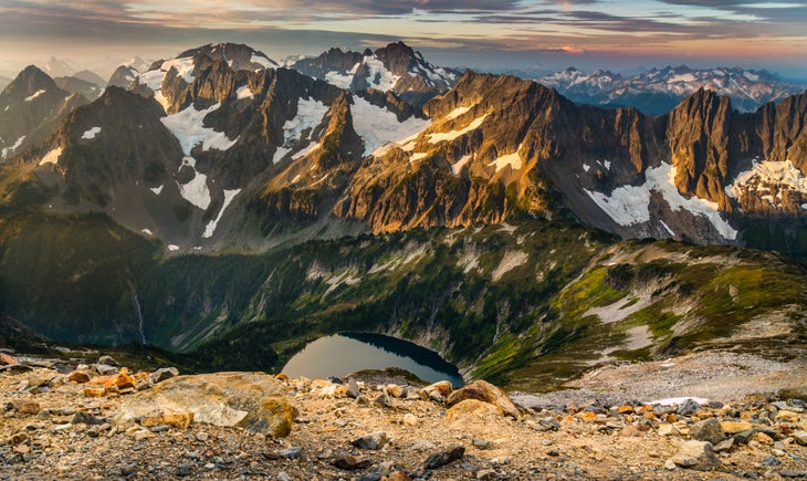
The Tour d’Aï and its neighbour, the Tour de Mayen, form distinctive rocky camel humps on the Vaud skyline. Located near Leysin in Switzerland, Tour d’Aï makes for an fun day hike in the Lake Geneva region — with plenty of more difficult options if that’s what you prefer!
One side of the Tour d’Aï is a sheer cliff, while the other is a gentler grassy slope. You can reach the top via both. The cliff side is, obviously, vertical and very exposed — but made easier with a via ferrata. From the top you have fabulous views of Lake Geneva, the Alps and the wide Rhône valley in Valais. On a good day, that is — I’ve done this hike twice and both times we mainly saw mist. But even without the view, it’s still a lovely hike.
Hiking trail info – Tour d’Aï
All options start and end in the ski resort town of Leysin (46.347610, 7.017399), which is served by public transport and has many eating and sleeping options.
The well-marked trail is not too steep or exposed. A couple of sections have chains and ladders. I wouldn’t recommend it during or after rain, though, as the well-worn rocks can get very slippery. This true for both the via ferrata and the trail.
The via ferrata route is rated as “difficult” and includes a chimney climb in one place and slight overhang in another. However I only found the first few steps really hard as there don’t seem to be enough handholds. Afterwards the climb is straightforward. Still, you wouldn’t want to attempt it if you have a fear of heights. Kai (10 years old and not yet 150 cm tall at the time) was a little short to make some of the steps by himself — he needed a push up from James.
There are no restaurants or shelters along the trail, but you can eat at the top of the Beneuse gondola.
Easiest hike: Leysin – La Beneuse gondola – Tour d’Aï – Leysin
Tour d’Aï: 2,331 m Height gain: approx 430 m Technical details: steepish trail in parts with some ladders and chains Distance: approx 8 km
Take the cable car from Leysin to La Beneuse. This summit is directly opposite the Tour d’Aï: take the trail down from La Beneuse, cross the valley and then follow the well-marked trail to Tour d’Aï. Return the same way, then take the well-marked trail down to Leysin.
You can also, of course, make the hike longer by walking up from Leysin, and shorter by taking the cable car back down.

Difficult hike: Leysin – La Beneuse gondola – via ferrata – Tour d’Aï – Leysin
Tour d’Aï: 2,331 m Height gain: approx 430 m Technical details: via ferrata; steepish trail in parts; some ladders and chains on the trail Distance: approx 8 km
From La Beneuse (or, if you walk up from Leysin, the valley between La Beneuse and the Tour D’Aï) walk up through the pasture to the base of the Tour d’Aï cliff. The start of the via ferrata is on the left side of the cliff face and clearly marked.
No chance of missing your way once on the via ferrata! After a couple of hours of climbing, you emerge on a grassy slope just below the summit. Take the walking trail down the mountain. Once off the Tour D’Aï follow the well-marked trail down to Leysin.

More difficult options
You can extend the hike to include the Tour de Mayen and/or make a longer walk down by traversing two other mountains, Truex and the Tour de Famelon.
Or, if one via ferrata is not enough, do two! Instead of walking up from Leysin you can take the Plan Praz via ferrata. While similar in length and height gain as the Tour d’Aï via ferrata, it is rated as extremely difficult. We have not done it.
Map of our hike – La Beneuse – via ferrata – Tour d’Aï – Leysin
(GPX download under the map)
You may also like
Hiking in switzerland – belvédère via ferrata, valais, leave a comment cancel reply.
This site uses Akismet to reduce spam. Learn how your comment data is processed .
Swiss Mountain Fun
Climb the mighty Tour d’Aï cliffs of Leysin | Hiking in Switzerland

Fabulous views of Lake Geneva, Mont Blanc & the Swiss Alps
Difficult hike (t4) | via ferrata (very difficult / k4) | rock climbing, mountain biking & ski resort nearby.
The Tour d’Aï and its neighbour, the Tour de Mayen, form distinctive rocky camel humps on the Vaud skyline. Located near Leysin in Switzerland, Tour d’Aï makes for an fun day out in the Lake Geneva region .
One side of the Tour d’Aï is a sheer cliff, while the other is a gentler grassy slope. You can climb to the summit both ways. From the top you have fabulous views of Lake Geneva, the Swiss Alps, Mont Blanc and the wide Rhône valley in Valais (on a good day that is; I’ve climbed up twice and seen mainly mist).
Two trails are described below:
► Tour d’Aï hike | 8 km | 430 m ↑↓ | T4 ► Tour d’Aï via ferrata | 8 km | 430 m ↑↓ | Very difficult / K4
JUMP STRAIGHT TO
Practical info
Getting there & away.
The trails described here start at the top of the La Beneuse gondola above Leysin, a small town and ski resort in the Vaudois Pre-Alps, and end in Leysin. You can drive to Leysin or take a train.
► Directions to the bottom of the Berneuse gondola on Google maps ► Cable car info in English
What to bring
You don’t need any special equipment to climb the Tour d’Aï in summer or early autumn, but I recommend shoes with good soles. You will need snowshoes or mountaineering equipment if there’s snow on the track.
You absolutely need the right equipment for the via ferrata or rock climbing. You can rent this at a sports store in Leysin.
Whatever the season, be prepared for sudden changes in weather. You’ll also be above the treeline, so don’t forget sun protection! You can eat at the Kuklos restaurant at the top of the Beneuse gondola, otherwise take a picnic lunch.
► Packing list | Day hike ► Packing list | Via ferrata set
Dangers & annoyances
The Tour d’Aï hike has steep drop-offs near the summit with a danger of falling. Also guard against:
- Heat stroke/dehydration
- Stomach bugs & parasites
- Hypothermia/exposure
The via ferrata should not be dangerous with the right equipment, but you could still be injured if you slip.
Trail descriptions and maps – Tour d’Aï
The hiking trails around Tour d’Aï are well-marked and generally not too steep. Around the base they are T2 , while the path to the summit is T4 . This part of the trail includes sections with chains and ladders, and some parts are exposed with steep drop offs. While it’s not very technical, I wouldn’t recommend hiking to the summit (or doing the via ferrata) during or after rain, as the well-worn rocks can get very slippery.
The via ferrata route includes a chimney climb in one place and slight overhang in another. However I only found the first few steps really hard as there don’t seem to be enough handholds. Afterwards the climb is straightforward.
There are no restaurants or shelters along the trail apart from at La Berneuse.
Tour d’Aï hike
Leysin – la beneuse gondola – tour d’aï – leysin.
Highest point: 2,331 m (Tour d’Aï summit) Height gain: approx 430 m Trail level: T3 – T4 | Steepish and exposed in parts, with some ladders and chains Distance: approx 8 km
Take the cable car to La Berneuse, then walk down to the valley between this summit and the Tour d’Aï. Cross the valley and then follow the well-marked trail to the Tour d’Aï summit. Return the same way, then take the well-marked trail down to Leysin.
You can, of course, make the hike longer by walking up from Leysin or shorter by taking the cable car back down.
Tour d’Aï via ferrata
Leysin – la beneuse gondola – via ferrata – tour d’aï – leysin.
Highest point: 2,331 m (Tour d’Aï summit) Height gain: approx 430 m Via ferrata level: Very difficult / K4 | Chimney climb; slight overhang Trail level: T3 – T4 | Steepish and exposed trail down in parts, with some ladders and chains Distance: approx 8 km
From La Berneuse (or, if you walk up from Leysin, the valley between La Beneuse and the Tour D’Aï) walk up through the pasture along the line of the chair lift and then to the base of the Tour d’Aï cliff. The start of the via ferrata is on the left side of the cliff face and clearly marked.
No chance of missing your way once on the via ferrata! After a couple of hours of nearly always vertical climbing, you emerge on a grassy slope just below the summit. Take the walking trail down the mountain. Once off the Tour D’Aï follow the well-marked trail down to Leysin.
► Download gpx
Nearby mountain fun
Eating & sleeping.
There are many sleeping options in Leysin, including a campground. The town also has many restaurants; for the best view check out the revolving Kuklos restaurant at La Berneuse.
► Kuklos restaurant info in English
Other hiking options
You can extend the Tour d’Aï hike to include the Tour de Mayen and/or make a longer walk down by traversing two other mountains, Truex and the Tour de Famelon.
Two trails of note:
- The 12 km chemin du Kuklos
- The long-distance 46 “Tour of the Vaudois Alps” trail passes through Leysin
For other hikes see SwissMobility — or here’s a (bad) photo of the hiking trails around Leysin and the Tour d’Aï to whet your appetite:

Other via ferrata options
If one via ferrata is not enough, do two! Instead of walking up from Leysin you can take the Plan Praz via ferrata. While similar in length and height gain as the Tour d’Aï via ferrata, it is rated as extremely difficult.
Rock climbing
There are five climbing routes on the Tour d’Aï cliffs, rated 5a – 7a+. You can find info here (in French). There are also rock climbing routes on Tour de Mayen and Tour de Famelon.
Mountain biking
There are several bike trails in and around Leysin:
- Leysin mountain bike park : The “Lisin” blue bike trail starts just under the La Berneuse cable car terminal, near the Kuklos restautant. Three other red and black mountain bike trails split off from this blue trail.
- Lac de Mayen bike trail , an 11-km loop from Leysin
- The long-distance 1 Alpine bike trail passes through Leysin
- The long-distance 68 “Alpes de la Région du Léman” bike route also passes through Leysin
Leysin is part of the Leysin-Les Mosses-La Lécherette ski area with 100 km of groomed ski runs. More information on the ski area website . The resort is covered by the Magic Pass .
Browse our map
More mountain fun near or like the tour d’aï hike and via ferrata in leysin:, leave a comment cancel reply.
Your email address will not be published. Required fields are marked *
Save my name, email, and website in this browser for the next time I comment.
This site uses Akismet to reduce spam. Learn how your comment data is processed .
The Tours d'Aï and Mayen are twin peaks visible from afar. The Tour d'AÏ is slightly higher than its neighbour, and also visited more frequently. It's a progressive climb which offers an aerial tour at the very end. Amazing views of Lac Léman, le Chablais, les Dents du Midi and the Mont Blanc massif from the summit.
Technical sheet
Description
Park in the rock climbing area's car park, at the upper end of Leysin resort, at the junction between Route des Chamois and Chemin de Prafandaz. Arriving from Aigle by "la route du Col des Mosses" (Mosses pass road).
Yellow indication signs provide direction information and travel times here and there.
( S ) Go past a livestock fence and take the small paved road leaving the car park heading north-east, surrounded by meadows. Motorised vehicales are forbidden on the road except for those of the alpine livestock farmers. After your first hairpin turn to the left, you'll get to a branch trail: follow the hairpin turn to the right. The slope gets steeper and the trail continues through forest cover. After a hairpin turn to the left, you'll reach a mountain chalet (admire the wooden shingles roof-covering).
( 1 ) Keep heading north-east passing under Berneuse cable car cables.
( 2 ) Shortly after the cable car line, leave the trail to go left up a steep grassy pasture ("Aï" sign, ski resort sign). Pass through a very narrow path and head north-west reaching Aï Lake and Aï chalets, with an impressive overhanging cliff above.
( 3 ) Go through the chalets on a small sloped path heading north (ignore the large path to the right which heads back to the Mayen Chalets). After the chalets, the path becomes a trail and heads north-east bypassing the cliff to the right. Ignore the trail that goes left towards the base of the cliff (rock-climbing area called "Le Sphinx"). You'll reach the base of a rocky passageway.
( 4 ) Steer left going up the passageway. It's a narrow trail but no need for rock climbing prowess. You'll reach a downhill grassy plateau. First walk along the edge of the plateau (west) then turn right (north-west) and go up a few bends to the foot of a ladder at the bottom of a rocky ledge.
( 5 ) Climb up the ladder. Keep going on the aerial trail (some areas equipped with barriers or chains) which regularly heads back up to the top due north-north-west. Outweigh the power of the summit and take a sharp turn to the left reaching the top.
( 6 ) The way back follows the same route you came on.
- S/E : km 0 - alt. 1,478 m
- 1 : km 0.61 - alt. 1,548 m
- 2 : km 1.86 - alt. 1,705 m
- 3 : km 2.57 - alt. 1,730 m
- 4 : km 3.5 - alt. 1,900 m - Chalets d'Aï
- 5 : km 3.77 - alt. 1,942 m
- 6 : km 4.23 - alt. 2,094 m - Lac Léman
- 7 : km 4.86 - alt. 2,231 m - Tour d'Aï
- S/E : km 9.73 - alt. 1,478 m
Useful Information
It takes around 2 and a half to 3 hours walk to get to the top (not counting rests) Water at the Aï lakes and chalets ( 3 ), where you can also get drinks and a simple meal. Hiking gear and boots a must. The last part of the climb, after the ladder ( 5 ) has passages aériens (aerial sections). Although these sections are well equipped (barriers, chains) you should stay vigilant . A map is necessary (at least the one found with the current description).
Always stay careful and alert while following a route. Visorando and the author of this walk cannot be held responsible in the event of an accident during this route.
During the walk or to do/see around
Aï Lake, overhung by the cliff called "Le Sphinx" which is a renowned rock-climbing area.
Unobstructed panoramic view from the summit: Lac Léman, Vallée du Rhône, Chablais massif, Dents du Midi, Mont Blanc massif...
Other walks in the area
tour de mayen.
The Tours d'Aï and Mayen are twin peaks visible from afar. The Tour de Mayen is slightly lower than its neighbour, not as busy and provides a more wilderness setting. The climb is progressive with two stages, the Chalets de Mayen and Segray Lake. Just beneath the summit, a very clear view of Lac Léman, les Diablerets, le Chablais, les dents du Midi and the Mont Blanc Massif.
La Grande Jumelle

A not too busy hike up to a summit offering a vast panoramic view. A relatively challenging route with some aerial passages requesting a certain sense of itinerary at times. The beginning of the hikes passes through Tanay site and its lake.
Le Grammont

Passing through Tanay preserved site, and its lake, you'll climb to the summit offering a unique view point over Lac Léman and a panoramic view over the surrounding mountains. A busy hiking trail with steep slopes but without any technical difficulty. N.B. The calculated height difference is over estimated, it's actually closer to 1000 metres.
Tête de Chalin
An uphill hike taking you to the foot of the Eastern Peak (Cime de l'Est), eastern peninsular of "les Dents du Midi", with mind-blowing mountain view points and a panoramic view extending towards the Vaudois Alps. A challenging itinerary with a short aerial path through ridges.
For more walks, use our search engine .
The GPS track and description are the property of the author.
Scan this QR code with your smartphone's camera.
Tour d’Aï : fun hike suitable to everyone
by Meline Cretegny | Sep 25, 2021 | Blog , Hiking , Moderate & more accessible | 0 comments
From forest trails to mountain side flowery fields and impressive ridges, this accessible hike offers stunning views of Lac Léman and the Alpes Valaisannes whilst promising a challenge for the whole group. There are multiple options to make this hike the most suitable for you, wether it be with the full elevation gain from Leysin to la Berneuse, or taking the gondola up to la Berneuse before attaching the rock tower, or hiking the whole thing from Leysin to Tour d’Aï.
Quick details, level: t4 (alpine hike) from lac d’aï, medium difficulty until la berneuse, elevation gain: 900m (or 250m from the top of la berneuse), distance: 9km round trip, time required: 5 hours round trip, depart from: leysin grand hotel (last train stop from aigle, 40min train ride from lausanne), from the last train stop, leysin grand hotel, follow the road east to the start of the trail found in the forest. the first part is quite steep, zig-zagging through the forest until the crossing with a larger gravel road. follow this one up left until you reach the refuge de temeley offering home-made tarts and refreshments. the path continues right for a couple meters and then take a left unto the small dirt path which goes all the way to la berneuse., from there, after having enjoyed the view of lac leman, follow the larger path down to lac d’aï towards the two rock towers. near a chair lift arriver, take a left unto another dirt path indicated in blue as tour d’aï. now the fun begins you’ll come across some ladders and railing to help with the climb. the path can get narrow in some section, but not to worry, it is very well maintained and should be no problem at all., for the descent, go back the same way to the lac d’aï (where you can also enjoy a cold beer in the traditional stone farm huts). instead of going back up, take a left following the signs to leysin village., ( follow the map below) , here’s the exact route:.
Tour de Mayen vue depuis le sommet de la Tour d’Aï
Submit a Comment Cancel reply
Your email address will not be published. Required fields are marked *
Save my name, email, and website in this browser for the next time I comment.

Tour d'Aï
Switzerland > Vaud
Great trail
Initial clarification: Tour d'Aï is the name of the summit, but it is indeed a round trip, not a mountain tour! We regret the start on a road and the ski slopes. But the view at the top is magnificent.
Note some overhead passages, to be avoided by people prone to vertigo.
A better experience awaits in the app!
- Detailed offline maps including IGN
- Trail recording
- Exclusive content, and more!

Already more than 200,000 users!
Map and elevation
Highest point
Lowest point
There and back
Download the map on your smartphone to save battery and rest assured to always keep access to the route, even without signal.
Includes IGN France and Swisstopo.
Getting there
Parking at the start of the hike.
About this trail
I indicate whether dogs are allowed or prohibited on this trail
Check Hika’s packing guide
From May to September
Ratings summary
Nearby hikes.

Tour de Mayen
15km • Hard •

Lac des Chavonnes
11km • Medium •

Lac de Bretaye
13km • Hard •

Rochers de Naye by Haut de Caux
12km • Hard •

Dent de Jaman and Rochers de Naye
10km • Hard •

This feature is in the app!
Also enjoy:
- Detailed offline maps
Download Hika
Enjoy a better hiking experience now.
Navigate to myswitzerland.com
Destinations
Your swiss holiday time.
Holiday destinations
- Summer holiday destinations
- Winter sports & ski resorts
- Family destinations
Attractions
- Top attractions
- UNESCO World Heritage sites / biospheres
- Travel by train, bus or boat
- Top museums
- Swiss Parks
- Scenic nature
Experiences
Additional content about subnavigation experiences.
- Family excursions
- Food & Wine
- Group excursions
- Guided tours
Summer & Autumn
- Bicycle & Mountain bike
- Adventure & Sports Summer
- Zoo & animal experiences
- Ski and snowboard
- Cross-country skiing
- Snowshoe and winter hiking
- Tobogganing
- Winter excursions
- Christmas in Switzerland
Cities & culture
- Parks, Gardens and Squares
- Architecture
Experience Tour
- Car, motorcycle - Grand Tour
- Train, bus, boat – Grand Train Tour
- Mountain excursions
Accommodation
- Typically Swiss Hotels
- Wellness & Spa
- Family Hotels
- Bike Hotels
- Boutique Hotels
- Inspiring Meeting Hotels
- Swiss Historic Hotels
- Luxury hotels
- Winter sports hotels
Other types of accommodation
- On the farm
- Bed and Breakfast
- Mountains huts
- Group accommodation
Transport & Stay
- Travel to Switzerland
- Barrier-free travel
- Tickets public transport
- Service & support
- Money and shopping
About Switzerland
- General facts
- Custom and tradition
- History of Switzerland
- The Swiss Art and Culture Scene
- Health Travel
- Sustainability
Weather & Climate
- Climate in Switzerland
- Snow Report
- Water and pool temperatures
- City offers
- Touring offers
- Wellness offers
- Nature and outdoor offers
- Offers for families
Where are you from?
- België (Nederlands)
- Belgique (Français)
- Deutschland
- Netherlands
- Russia (Россия)
- Schweiz (Deutsch)
- Suisse (Français)
- Svizzera (Italiano)
- Switzerland (English)
- United Kingdom
- Canada (English)
- Canada (Français)
- China 中文简体
- China 中文繁体
- Gulf countries العربية
- Japan 日本
- Korea 한국어
- United Arab Emirates
- New Zealand
- International

Language, region and important links
- Slovenština
Service Navigation
- Help & Contact
Tour d'Aï - Via ferrata
The Tour d'Aï is short and powerful. The via ferrata is difficult, highly exposed, at one point even with a slight overhang, and has excellent safety. Even on the normal route there is a ladder and points which are equipped with chains and hand-rails; it is an exposed route which in the upper section is on the side of the mountain in shade.
Difficulty K4. Difficult. Starting-point From Aigle on the Lausanne - Sion rail line with the rack-railway to Leysin, district of Feydey (1,389 m). It is 10 minutes eastwards on foot to the valley station (approx. 1,320 m) of the gondola cable-car to Berneuse (2,045 m); this operates from May to October. Walk-in From the Berneuse mountain station, head northwards down into a hollow (1,905 m) with a chairlift valley station. On paths, climb more or less along the lift run up to the grassed ridge. Traverse to the right and over a mound of scree to the start of the via ferrata (approx. 2,190 m) on the west wall, roughly in the fall line of the left of the yellow overhangs. Tour d'Aï via ferrata The via ferrata follows the "Voie des Vires" over a series of ledges running diagonally upwards and to the right, climbs up through a chimney, conquers a vertical to overhanging wall, follows a grassed ledge to the left, and leads over an edge to the top of the Tour d'Aï. Descent The descent uses an exposed, marked normal path over the south-east ridge, firstly bearing left of the cut over steep slopes, then over a sharp ridge of rock which widens out and becomes grassy. Finally, keeping to the left, you reach a rocky channel. At the foot of this, bear right to Chalets d'Aï (1,892 m) above the lake bearing the same name; from here you can climb again in 20 minutes to the Berneuse mountain station, or take hiking paths down to Leysin-Feydey in 1 hour. Region: The Alps of Vaud, Leysin Peak: Tour d'Aï (2,330 m) Time required: climb 2 hours, descent to the Chalets d'Aï 1 hour, further climb to Berneuse 20 minutes, further descent to Leysin-Feydey 1 hour. Variation in height: climb 430 m, via ferrata 140 m; 1,070 m to Leysin-Feydey.
Discover the surroundings
Advertisement, travel information: leysin, destination.
Leysin Tourisme Rte de la Cité 27 1854 Leysin +41 (0)24 493 33 00 [email protected] Website
- Hotel booking
- Holiday rentals
- Group houses groups.swiss
- Railway timetable
Local Information
- Restaurants
- Family experiences
Winter sports
- Snow report
- Wintersport activities
- Swiss Ski School
- Lakesides / Swimmingpools
- Climatic data
- Swisstravelcenter Hiking Maps
- Swisstravelcenter Mountainbike Maps
- Swisstopo Hiking Maps
Current Offers
Montreux cycling holidays: lakes route lake geneva - lucern.
Price per person in double room valid: 19.04.2024 - 31.12.2024
Caux Palace - Centre de conférences et de séminaires, Caux Escape to Caux for a Productive Working Day
valid: 19.04.2024 - 31.12.2024
Villars Palace, Villars-sur-Ollon Plan your next event in the Swiss Alps
Price per person in a grand-lit room valid: 10.06.2024 - 23.09.2024
Discover Leysin

VIA FERRATA DATABASE
Your English Language Guide to Via Ferrata in Europe and beyond

TOUR D'AI
VAUD, SWITZERLAND
VIA FERRATA (D+) K4
PHYSICAL RATING: 2 VERTIGO RATING: 2
TECHNICAL RATING: 3
SUMMIT RATING: 4 STYLE: CLIMB SATISFACTION: 4
Departure Altitude: 2190m Arrival Altitude: 2330m Climb (or descent): 140m Length: 450m Time: 3 hours 30 mins
SPECIAL FEATURES
Footbridge: 0 Monkey Bridge: 0 Ladder: 0 Zip Line: 0 Net: 0
ACCESSIBILITY
Open: June to October Parking: By car, you can park at base on Les Chamois, above Layesin and hike up which takes about 1hr 30mins to start of via ferrata or follow the cable car instructions as below. By train, take train to Leysin Feyday, then cable car up to Berneuse, via ferrata is about a 30 min walk down and up.
WHAT TO KNOW!
The legendary Tour d’Aï Via Ferrata above Leysin.
A truly fantastic intermediate (D+/K4) course for those who have previous VF experience. The views and the sensation are excellent, especially the famous “chimney” half way up.
One of the best Via Ferrata summits possible that truly rewards your efforts. The views from the top and the feeling of being on top of an unreachable plateau are unique beyond words.
Take the cable car up from Leysin to Berneuse, and then climb about 300m up to the start, by the Chaux de Mont. the start of the course is quite easy with a shallow gradient. Once you reach the vertical section, the via ferrata enters a fairly difficult section from the chimney up. The section after the chimney is probably the toughest part of the course with some overhang. Once you reach the last ledge, the final part is pretty simple. The only issue with this course is that it is over a bit too soon.
The walk down is nearly as spectacular, but i would recommend some poles for this path as it is fairly dangerous.

MY TOUR D’AI

Tour d'Aï - 4 Things to Know Before Visiting
Rock Climbing Spots
Mountain Peaks
Short Hikes
Things to know
About tour d'aï.
- Activities and tours near by
- Attractions near by
- Discover More Attractions in Vaud
- Location and Map
The Tour d'Aï is a beautiful mountain in the western Bernese Alps, overlooking Leysin in the canton of Vaud. The mountain itself has some parts that you can only climb up with the help of the ladders fixed to the rock. From the top, there are amazing views of the Bernese alps as well as Lake Leman and Lake Geneva.
Add your visit
Hotels near Tour d'Aï
Hotels to stay near Tour d'Aï
Leysin Lodge

Guest rating:
Roc d'Orsay E51

Exceptional
Bed & Breakfast l'Epicea

Hotel Le Grand Chalet

View all hotels
Activities Around
Attractions near tour d'aï.
1.4km from Tour d'Aï
The mountain above Leysin and Aigle is famous for Kuklos, a revolving restaurant accessible by cable cabin from town.
Aigle Castle
6.65km from tour d'aï.
The Château d’Aigle is a historic castle with medieval origins and strong roots in the local wine industry. It is a Swiss heritage site of national significance.
Rochers de Naye
6.93km from tour d'aï.
A mountain overlooking Lake Geneva, Rochers-de-Naye straddles the range separating the lake from the valley of the Sarine.
Chillon Castle
7.39km from tour d'aï.
Chillon Castle is an Island Castle which is situated in the eastern end of the lake on the shore between Villeneuve and Montreux. Chillon is amongst the most visited castles in Switzerland and Europe.
Col de Bretaye
8.27km from tour d'aï.
Bretaye is a mountain pass located above Villars. The pass is connected to Villars by the Bex-Villars Bretaye railway, which is the second-highest railway in the canton.
Col des Mosses
Col des Mosses is a mountain pass at an elevation of 1.452m above the sea level, located in the canton of Vaud, in Switzerland. The Col des Mosses is also on the Alpine Pass Route hiking trail and is a winter sports center.
Discover more attractions near by
Discover More Attractions in Vaud , Home of Tour d'Aï
56 attractions
The canton of Vaud is the third largest of the Swiss cantons by population. The capital and biggest city is Lausanne, officially designated "Olympic Capital" by the International Olympic Committee and hosting many international sports organizations.
Location of Tour d'Aï
For more information about Tour d'Aï , visit: https://en.wikipedia.org/wiki/Tour_d%27A%C3%AF
To view all hotels near Tour d'Aï , visit: Hotels near Tour d'Aï
- SAC route portal
- Classified ads
- SAC Route Portal
- Subscribe to the SAC Route Portal
- Tour planning
- +41 31 370 18 18
- Contact Contact
- Die Gesundheitspartnerin des SAC CSS
- Huts and Tours
- Training and safety
- Latest routes
- Situation warnings
- Protection provision
Keys SAC route portal / SAC-App
Faq route portal.
- Via ferrata
- Mountain hiking
- Via ferrata Tour d'Aï
- Descent from the Via ferrata Tour d'Ai
Descent from the Via ferrata Tour d'Ai Tour d'Aï 2330 m
- Difficulty T3+
- Ascent 160 m
- Descent 1:20 h, 460 m
Route description
- Show segment on map
Additional information
La Berneuse, Bergstation (2044.1 m)
www.region-du-leman.ch/de/P22651/kabinenbahn-leysin-berneuse
- Show on map
- Get there Google Maps
Leysin-Feydey, Bahnhof (1398 m)
- Report a status warning Report a status warning
- Report proposed change to route description Report proposed change to route description
Daniel Anker
Daniel Anker is a Bernese author and photographer. The historian has written around 40 ski tour, hiking, via ferrata and mountain bike guide books as well as detailed monographs on individual peaks in Switzerland.
Further information
Safety when hiking, hike responsibly, our recommendations.
Berg- und Alpinwandern
Gipfelziele Freiburg
Subscription to the SAC Route Portal
Tourenportal/App-Abo Jahreszahlung
En famille vers les cabanes du cas, les alpes, un monde vivant, sac-schlüsselband, sac-taschenmesser, sac-brändi dog xs, hütten der schweizer alpen / cabanes des alpes suisses, our partners.
Leadingpartner
Main partner
- [object Object]
- Routeportal
- SAC-CAS App
- Becoming a member
Subscribe to the SAC-Newsletter
- SAC/CAS Facebook
- SAC/CAS Instagram
- SAC/CAS Youtube
- Data protection
- Legal information
- Trip Reports
- Areas & Ranges
- Huts & Campgrounds
- Logistical Centers
- Fact Sheets
- Custom Objects
- Plans & Partners

Tour d'Aï Trail
Parent: Tour d'Aï
5001 miles away
You need to login in order to vote!
Don't have an account.
- Rating available
- Suggested routes for you
- People who climb the same things as you
- Comments Available
- Create Albums
- Route Finder
- Route Planner
- Travel Guide
- Places to visit
- Eat & drink
- Accommodation
- Ski resorts
- Current Conditions
- Avalanche Report
- Collections
- Travel Stories
- Publications
Via Ferrata Tour d’Aï

Track types
Tips and hints, destination, coordinates, book recommendations for this region:, similar routes nearby.
- Via Ferrata Plan Praz
- Klettersteig Tour d'Ai - Ferrata
Questions and answers
Would you like to ask the author a question?
Help others by being the first to add a review

Photos from others
Weather at the route's trailhead.
- Show images Hide images
Excursions and leisure tips for the region
2-FOR-1 GA TICKETS WITH OUTSIDE+
Don’t miss Thundercat, Fleet Foxes, and more at the Outside Festival.
GET TICKETS
BEST WEEK EVER
Try out unlimited access with 7 days of Outside+ for free.
Start Your Free Trial
Powered by Outside
I Asked AI to Plan a Hike for Me. Here’s What Happened Next.
Could an ai chatbot be a weekend adventurer's new best friend.
Heading out the door? Read this article on the new Outside+ app available now on iOS devices for members! >","name":"in-content-cta","type":"link"}}'>Download the app .
As an editor at Backpacker, infatuation with maps and piles of gear is in my job description. I spend my workdays (and yes, sometimes my vacation days) sweating details like trail mileage, water sources, and meal plans. But even the most organized trip planners need some help now and then.
Earlier this summer, our team shifted to a four-day workweek. I couldn’t wait to use the extra time to go hiking; I recently moved to Washington State , where every trail seems to lead to mystical, moss-laden rainforest or glacier-capped peaks. I promised myself I’d aim to explore one new trail every week. The only problem? When you spend all week planning hikes for work, sometimes the last thing you want to do is plan one on your day off . On Friday I’d sleep a little late, and by the time I’d choose a trail, study the maps, and get out the door, the best hours of the day were already behind me. I needed an alternative to scrolling Backpacker and my handful of hiking apps.
Like everyone on earth, I’d heard the buzz around AI chatbots like ChatGPT and Google Bard, but I was a skeptic. Until this summer, I hadn’t so much as poked around with AI. That is, until I found myself overwhelmed with trail options.
My Virtual Hiking Assistant
I’m far from the first person to consider using AI to plan trips. Journalists at National Geographic , the New York Times , and others have written about planning entire vacations with the help of a chatbot. I read these accounts and wondered if AI could help me decide where to go hiking.
ChatGPT or Google Bard have a slightly different approach to trip planning than a human. These tools are powered by large language models (LLMs), which consume and synthesize huge amounts of text from across the web. Using this data, LLMs excel at predicting words in a sequence. The result is a bot that can engage in human-like conversation. That makes them great at answering very specific questions.
“Imagine you are trying to plan a trip using Google search. You cannot directly ask, ‘can you plan a trip for me in Bali?’” Wen Yang, an engineer at Outside , told me. “You will get tons and tons of ads.” Instead, you have to perform multiple searches, sort the helpful results from the unhelpful ones, and synthesize them into a plan.
According to Yang, a chatbot can help get you to an answer more quickly by doing some of that work for you. Paired with some supplemental research, she assured me that AI tools are very effective trip-planning assistants.
“It’s very easy talking to one tool, and you get 80 percent of the daily itinerary,” she said.
Outdoorsy AI
I’d been toying with the idea of planning a short hike with AI when Yang and her team announced that Outside was in the process of creating its very own chatbot called Scout, which will become available to Outside+ members later this year. Scout is powered by ChatGPT, but pulls all of its information from publications in the Outside network. It doesn’t write trip reports or guides; instead, it’s kind of like having a smart friend who’s read every single article Backpacker and our sibling publications have ever written. Ask it to suggest, say, a dayhike in Yosemite or an overnight trip in the Smokies, and Scout will come back with a recommendation, plus links to well-researched, expert-written guides from Outside’s (human) journalists. Yang told me that Scout can help with trip planning, comparing gear, meal planning , and more, and that it’s designed to cater to a user’s specific interests.
I hoped that Scout might be the answer to my trip-planning woes . So on a recent day off, I decided to conduct a little experiment: I’d ask Scout where to go hiking and, as long as it was safe and legal, I’d go along with its plan.
Yang had told me that more specific questions precipitate the best results from a chatbot. So I typed in: “Can you recommend a hike in North Cascades National Park that’s between 7 and 12 miles with a view of mountains?” In response, Scout suggested two different trails and gave me some info on distance, difficulty, and the scenery. When I asked for more info, Scout also told me about a way to tack on some extra mileage, so I had even more options.
I decided on the Cascade Pass trail , a 7-mile out-and-back that Scout claimed had some of the most classic views of the North Cascades.
As I continued to plan my hike, I began to run into some of AI’s limitations. Scout is built on ChatGPT, which can only access data pre-dating September of 2021. As a result, the bot couldn’t tell me anything about the current weather report, road conditions, or trail closures. However, it did suggest websites where I could find the information I needed. With a few supplemental Google searches, I had everything I needed.
As I drove into the Cascade Pass trailhead, I knew I was in for a good day. The views began from the road: Trickles of glacial melt streamed down steep rock walls springing from the deep green valley floor to my right. I could see snowfields and blue-tinged glaciers in the distance. And that was before I even parked.
Once my shoes hit the dirt, things only got better. After a few shady miles through the forest, I wandered into subalpine meadows dotted with pink flowers. A dramatic ridgeline dominated the skyline on one side, with more peaks appearing as I climbed. At the pass, I gazed into a glacier-carved valley lined with some of the most attractive mountains I’ve ever seen. But I wanted more.
Scout had told me I could continue up the Sahale Arm for even more views, and this is where the fun really began. As I climbed higher, the Cascades stretched out in every direction. I peered into a cirque at Doubtful Lake, its deep waters an enticing emerald. I strolled past six mountain goats, including three fluffy kids. On a saddle below the Sahale Glacier, I enjoyed lunch with 360 degrees of alpine vistas. I felt like I was in the Alps. Not bad for a hike a robot planned for me.
Pleasant Surprises
As I munched on Cheetos on my drive home, I reflected on the AI-powered hiking experience. My day in the mountains was wonderful—but was it any different than a hike planned the traditional way? I’d say so.
Because I’d put so much trust into Scout before I hit the trail, my mindset on my hike was one of discovery. Normally, I’d read blog posts, look at photos, and study the maps ad nauseam, and get a good sense of my route ahead of time. This time, the whole point was to abbreviate the planning process (while still making sure I was prepared for a safe hike, of course). As a result, I was really pleasantly surprised by everything I encountered on the trail. I think that blind trust could just as easily have led to disappointment, but in this case, it was a delight.
At the same time, there were some downsides, the main one being the crowds. Unless you specify otherwise, Scout might recommend the most popular trail in an area—the Cascade Pass Trail is one of these. But despite bumping elbows with hordes of other hikers, it was a great trail to get my first taste of North Cascades National Park. Next time, I’ll ask Scout for a trail with some more solitude. And if I really want to get off the beaten path, I’ll probably plan my trip the old fashioned way—with a map.
You can hear more about my experience hiking with AI on the Outside Podcast .
Popular on Backpacker
Related content from the outside network, what’s it like to go on a 200-person hike better than you think., how to pack for backcountry skiing, the original yosemite firefall, hiker charges mountain lion.
IMAGES
VIDEO
COMMENTS
Tour d'Aï: 2,331 m. Height gain: approx 430 m. Technical details: steepish trail in parts with some ladders and chains. Distance: approx 8 km. Take the cable car from Leysin to La Beneuse. This summit is directly opposite the Tour d'Aï: take the trail down from La Beneuse, cross the valley and then follow the well-marked trail to Tour d ...
The western cliffs of Tour D'Aï have some famous climbing routes set up by some top climbers. For access to these and the Via Ferrata route, follow the trail description to the Téte D'Aï and follow the sign posts for the Via Ferrata route. The path follows the base of the cliffs and bolts begin to appear the further along it goes.
Trail level: T3 - T4 | Steepish and exposed in parts, with some ladders and chains. Distance: approx 8 km. Take the cable car to La Berneuse, then walk down to the valley between this summit and the Tour d'Aï. Cross the valley and then follow the well-marked trail to the Tour d'Aï summit. Return the same way, then take the well-marked ...
13.00 km +851 m -849 m 6h 10 Difficult. Departure from Leysin (Vaud) The Tours d'Aï and Mayen are twin peaks visible from afar. The Tour de Mayen is slightly lower than its neighbour, not as busy and provides a more wilderness setting. The climb is progressive with two stages, the Chalets de Mayen and Segray Lake.
From forest trails to mountain side flowery fields and impressive ridges, this accessible hike offers stunning views of Lac Léman and the Alpes Valaisannes whilst promising a challenge for the whole group. There are multiple options to make this hike the most suitable for you, wether it be with the full elevation gain from Leysin to la Berneuse, or taking the gondola up to la Berneuse before ...
Initial clarification: Tour d'Aï is the name of the summit, but it is indeed a round trip, not a mountain tour! We regret the start on a road and the ski slopes. Get App ... Trail recording Exclusive content, and more! Download app Download app Already more than 200,000 users! Map and elevation ...
Approach to Via ferrata Tour d'Ai Tour d'Aï 2330 m. Difficulty T2 Ascent 1 h, 300 m; Descent ... The historian has written around 40 ski tour, hiking, via ferrata and mountain bike guide books as well as detailed monographs on individual peaks in Switzerland. Further information. Cultura. Safety when hiking.
The Tour d'Aï is short and powerful. The via ferrata is difficult, highly exposed, at one point even with a slight overhang, and has excellent safety. Even on the normal route there is a ladder and points which are equipped with chains and hand-rails; it is an exposed route which in the upper section is on the side of the mountain in shade. K4.
Via ferrata Tour d'Ai The via ferrata follows the Voie des Vires on ledges diagonally up to the right, climbs through a chimney, overcomes a vertical to overhanging wall, follows a grass band to the left before following an ridge to the summit of the Tour d'Aï (2331 m). ... The historian has written around 40 ski tour, hiking, via ferrata and ...
3 / 3 Slide 3 of 3 via ferrata tour d'ai leysin hiking wandern klettern ShowPrevContent ShowNextContent. Difficulty K4. Difficult. Starting-point From Aigle on the Lausanne - Sion rail line with the rack-railway to Leysin, district of Feydey (1,389 m). It is 10 minutes eastwards on foot to the valley station (approx. 1,320 m) of the gondola ...
The Tour d'Aï is a mountain in the western Bernese Alps, overlooking Leysin in the canton of Vaud. It is located near the Tour de Mayen, on the range lying between the Rhone and Col des Mosses, south of Lake Geneva, from where both summits can be easily seen. The summit can be accessed via a trail on its northern slopes, from the alp of Aï ...
By car, you can park at base on Les Chamois, above Layesin and hike up which takes about 1hr 30mins to start of via ferrata or follow the cable car instructions as below. By train, take train to Leysin Feyday, then cable car up to Berneuse, via ferrata is about a 30 min walk down and up. ... MY TOUR D'AI ©2021 by Via Ferrata Database ...
The Tour d'Aï is a beautiful mountain in the western Bernese Alps, overlooking Leysin in the canton of Vaud. The mountain itself has some parts that you can only climb up with the help of the ladders fixed to the rock. From the top, there are amazing views of the Bernese alps as well as Lake Leman and Lake Geneva.
Tour d'Ai - Berneuse Follow the exposed, marked normal route along the southeast ridge, first to the left side of the ridge, then directly along the sharp arete, which later widens and becomes grassy. ... The historian has written around 40 ski tour, hiking, via ferrata and mountain bike guide books as well as detailed monographs on individual ...
Tour d'Aï Routes : SummitPost.org : Climbing, hiking, mountaineering
There is a possibility to reach the top by a hiking trail or Via Ferrata. The walking time from the mountain station to the summit is about 3 hours while the Via Ferrata should take around 2 hours. ... Leysin - Via Ferrata Tour d'Ai Via Ferrata Plan Praz Klettersteig Tour d'Ai - Ferrata These suggestions were generated by our system . Questions ...
I decided on the Cascade Pass trail, a 7-mile out-and-back that Scout claimed had some of the most classic views of the North Cascades. As I continued to plan my hike, I began to run into some of AI's limitations. Scout is built on ChatGPT, which can only access data pre-dating September of 2021. As a result, the bot couldn't tell me ...