Filmora for Mobile
Easy-to-Use Video Editing App

- Video Editor >
- Mac Video Editor >
- Video Editor for iOS >
- Video Editor for Android >
- Video Editor for iPad >
- Video Editor Online >
- Creative Assets >
- Compound Clip NEW
- Screen Recorder >
- Speed Ramping >
- Keyframing >
- Green Screen >
- Auto Beat Sync >
- Audio Visualizer >
- Auto Synchronization >
- Silence Detection >
- Audio Ducking >
- AI Copywriting NEW
- Add Text To Video >
- Text-To-Speech (TTS) >
- Speech-To-Text (STT) >
- Multi-Clip Editing >
- Video Effects >
- Preset Templates >
- AI Portrait >
- Boris FX >
- NewBlue FX >
- AI Copilot Editing >
- AI Text-Based Editing >
- AI Music Generator >
- AI Text-To-Video >
- AI Vocal Remover >
- AI Thumbnail Creator >
- AI Image >
- AI Copywriting >
- AI Smart Cutout >
- AI Smart Masking >
- Meet AI >
- ChatGPT Video >
- AI-Generated Video >
- Metaverse >
- AI Marketing >
- AI Video Editor >
- AI Video Generators >
- AI Music Composers >
- AI Voice Generators >
- AI Music Remixer >
- YouTube Monetization >
- Intro Video >
- Promo Video >
- Explainer Video >
- Slideshow Video >
- Product Video >
- Marketing Video >
- Presentation Video >
- TikTok Video Ads >

Master Class
Creator hub, content hub, marketing calendar, video trends, diy special effects.
- Trendbook >
- Creative Garage >
- Refer A Friend Program >
- Achievement Program >
- Video Events >
- Creator Spotlight >
- Get Certified >
- Best Video Editor Software >
- Screen Recording Tips >
- Audio Editing Tips >
- Video Editing Tips >
- Animation Tips >
Video Tutorial
Version history, customer stories.
- Affiliate >
- Business >
- Download Download Download Pricing Pricing Pricing
- Add animation keyframes presets or customize as you like
- Auto crop or Pan and Zoom photos & videos to fit project ratio
- Plentiful transitions, effects and templates for polishing animated travel map
*Click on the video to learn how to make an animated map for a video >>
0:00 - Find Location on Google Map; 3:07 - Create Animated Map Video
How to Make an Animated Travel Map Video?

Benjamin Arango
Mar 27, 2024• Proven solutions
Animated travel map videos make it easy for the viewers to follow the routes from the source to destination locations right on the single screen. While the static maps would only allow the audience to see the markers from where the journey would start and is expected to end, the animated ones show the real-time movements and therefore look more interactive when viewed.
That said, here you will learn how to create an attractive and engaging animated travel map video using one of the easiest post-production applications, Wondershare Filmora, which is widely appreciated by amateurs and professionals throughout the globe. In another section, you will also learn about an alternative program that might be of some help in case you are more into online designing.
- Method 1: Make Animated Travel Map Videos with Location Video Maker - [Video Tutorial]
- Part 1. Prepare the Travel Map Materials
- Part 2. Make Animated Travel Map Videos with Filmora
- Method 2: Make Interactive Animated Travel Map with Pictramap
- Method 3: Create Animated Travel Map Using Multidev
Method 1 Make Animated Travel Map Videos with Location Video Maker
The entire process of creating an animated travel map video in Wondershare's Filmora is categorized into two parts, wherein the first part you will collect all the ingredients that are needed to get started, and in the second part you will actually make an animated map using the tools and features present in Filmora.
Watch a video tutorial to see how to make an animated map for a video:
For Win 7 or later (64-bit)
For macOS 10.14 or later
Part 1: Prepare the Travel Map Materials
Following are the ingredients and the methods to collect them for animated travel map preparation:
Step 1: Get the Map
The first thing that you would need to prepare an animated map is an image of a realistic map. Thanks to Google and Microsoft, these things are now pretty easy to arrange. The process is given below:
- Launch your preferred web browser
- Type google.com in the address bar or the search box and hit Enter
- Scroll to zoom out so you can see the entire world map on one screen

- Type Snipping Tool in the Cortana search box present on the left side of the Taskbar
- Launch Snipping Tool , and use it to capture the screenshot of the map
Note: Snipping Tool is a built-in app in Windows 10 and is available for free. If you are using any other operating system, or have a different program to capture the screenshots, feel free to use it according to your convenience.
- Save the screenshot you captured as a JPG file on your PC
Step 2: Mark Out the Map Path
The next step in the process of preparing an animated travel map is to mark your route on it. To do so, you can use any of your preferred photo editing tools. However, to keep this illustration simple, Microsoft Paint is used here, and the method is given below:
- Right-click the screenshot you just captured
- Go to Open with on the context menu, and then click Paint from the submenu that appears
- Pick your preferred color from the pallet of the Paint interface. It is advisable to use an eye-catchy shade such as Red
- Use the Sphere shape tool to draw a circle over the source and destination locations on the map
- Use the Line tool to draw a line from the source point to the destination. Try giving the line a few turns to make it look realistic
- Go to File > Save As , and save the marked image with a different name
Note: Once this is done, you should have two image files of the map, i.e., one without the marks and one with it
Step 3: Download Some Travel Icons
Another important ingredient in an effective travel map animation is touring icons such as location marker image, a traveling medium symbol like a helicopter, airplane, car/bike (for short distances), etc. A couple of websites that offer royalty-free stock photos at absolutely no cost are listed below:
- Wondershare Filmstock
Note: Although the websites given above allow you to download and use their stock images and icons for free, you may need to give credits to the designers/creators of the symbols while using their objects. Therefore, you are suggested to check the Terms & Conditions and norms of usage of the elements before downloading and adding them to your projects.
Part 2: Make Animated Travel Map Videos with Filmora
After you have gathered all the necessary ingredients that are required to create a travel map animation , it is now time to get to work. The following instructions would guide you through the step-by-step process of preparing a decent and realistic animated travel map in Wondershare Filmora :
Step 1: Import Ingredients to Filmora and Add Them to the Timeline
Launch the video editor on your computer, click anywhere inside the Media window at the upper-left area, and import all the images and icons that you collected earlier to program. Next, drag both the images of the map, i.e., with and without the marks to the Timeline, and ensure that they are of the same duration and are placed on the same track.

Note: Be sure to put the map without the marks first, and then the one with the marks. Also note that the images have the playback duration of 5 seconds in the Timeline by default, and this tenure can be reduced or increased by dragging the side handle of the media to the left or right respectively.
Step 2: Add Transition for Illusion of Route Appearance
Go to Transition from the standard toolbar at the top, locate the Erase Slide transition effect from the available presets, and place it in between the two image files that you earlier added to the Timeline. Next, click and drag either of the side handles of the transition to the end of the media clip. Notice how the other side of the effect is expanded in equal proportion.

Step 3: Preview and Export
Press the Spacebar on the keyboard to preview the video and see if the route appears as if it is being drawn on the map. Once the animation looks acceptable, click EXPORT from the top-center, go to the Local tab on the Export window, select MP4 from the formats list in the left, and click EXPORT from the bottom-right corner to export the current animation to MP4.
Step 4: Customize the Travel Map Media
Either start a new project and import the video of the map you exported in the previous step to the app and then to the Timeline, or remove the existing media from the Timeline in the same project, and add the exported video to it for convenience.

Next, position the Skimmer ( Playhead ) a couple of frames before the one the route line appears and starts stretching from, and click the Split icon from the editing toolbar above the Timeline itself. Repeat this process for the other side of the media, i.e., position the Skimmer a couple of frames after the route line reaches the destination location, and click the Split icon again. Then remove the separated segments from both the sides by selecting them and pressing Delete on the keyboard, leaving only the portion where the animation is visible.

Optionally, right-click the media that is left behind in the Timeline, and go to Speed and Duration from the context menu. On the Custom Speed box, drag the Speed slider to the left to decrease the playback speed resulting in the increased duration of the media. Alternatively, you can manually enter a value in the Speed box to get precise tenure. Click OK when you are done.

Step 5: Add Animations to Travel Map
Right-click the media in the Timeline, and go to Add Animation from the context menu. Make sure that the Skimmer is on the first frame, and add several keyframes as explained below:
- Click Add to add the first keyframe

- Move a couple of frames further, and click Add one more time. Now, while you are on this second keyframe, use the Scale slider to zoom in to the map so the source location remains within focus.

- Next, move the Playhead further and add another keyframe a couple of frames before the route line hits the edge of the window.
- After this, move the Playhead again and position it where the route line reaches its destination location. Add another keyframe here as well, and move the map in the Preview window so the focus is now on the destination.
- Move the Playhead a few frames further, add another keyframe, and use the Scale slider to zoom a bit more into the map to make the entire animation look realistic. Click OK to save the changes.
Step 6: Add Icons and Titles, and Export the Project
Drag the image of the traveling medium to the Timeline, and place it on the frame the route line starts from. Make sure to place the image on the track above the map, and stretch it to the end so it remains visible throughout the animation. Next, use the method explained above to add keyframes to move the medium along with the route line from the source to the destination. Optionally, add the image of the location marker at the destination point, go to Transition , and add your preferred transition effect, preferably Dissolve , to the marker track in the Timeline so it looks as if it has appeared as the medium arrived the destination.
Get back to the first frame in the Timeline, go to Titles on the standard toolbar, and add a title preset somewhere near the source location. Resize the text, change the format as needed, and add your preferred caption to it such as the start time, name, etc. Reduce the duration of the track so the title appears for a few frames, preferably before the map animation starts. Click OK when done. Repeat this process for the destination point as well.
Once everything is complete, click the Play button in the Preview window to review your work. If the video looks acceptable, click EXPORT from the top-center of the interface, and use the method explained earlier to export the animated travel map in your preferred format.
Method 2 How to Make Interactive Animated Travel Map with Pictramap
If you don’t want to install a dedicated animation software on your computer due to limited hardware resources or some other reason, there is an online solution called Pictramap to create a travel map animation using a web browser. The web app offers a lucrative interface that could be easily understood and worked with to produce an animated map for free.
The process to create an animated travel map with Pictramap is given below:
Step 1: Create a Project
Launch your favorite web browser, go to https://www.pictramap.com/ , click Create yours now, it’s free , and sign up to Pictramap using your preferred method. When you are on the Dashboard , enter a name in the field available under the My Projects section, and click Create to create a new project (the animated map).

Step 2: Define the Locations and Method of Commute
On the map, right-click the location you want to start your journey from, enter the name of the location or any other significant title, and click Add . Click the location marker, click the Travel Mode icon, and select your preferred mode of traveling. Repeat this process to mark the destination location as well.

Step 3: Preview the Animation
Click the View Animation button from the upper-right corner of the page to see the animated travel map .

Downsides of Using Pictramap to Create Animated Travel Map Video
Although Pictramap allows you to create a travel map animation with ease and extremely quickly, at the time of this writing, it offers no way of downloading the animation to your PC, and therefore it couldn’t be used in your projects.
If you are using Wondershare Filmora, you can use its built-in screen recording feature to record the animation that Pictramap plays, and then save the captured footage as MP4 or any other format on your computer. This video can then be imported to your projects for further uses.
Method 3 How To Make Animated Travel Map Using Multidev
Multi.dev is still a new web-based application to build awesome animated maps, but it’s good! The application helps you create presentations about all your recent and previous trips. And the interface is also hassle-free.
So, follow this step-by-step guide to making animated maps with Multi.dev.
Step 1: Open Multi.dev
Visit Multi.dev from your internet browser.

Once the tool gets open, you will see a demo video. This example clip will have animated maps of different locations. So it is up to you whether to use the same example and edit the places you have been to or are planning to visit. Or, simply create a new animated map from scratch.
Step 2: Choose Your First Location
Take your mouse cursor on the left side of the application and type the first location in the search bar. As soon as you do it, you will see that the “travel arrow” will automatically begin from there. Likewise, type and select the next location through the search bar.
Once you type the location, you will see 8 travel modes, including airplane, bus, and train. You can select the same mode for all sites or a different mode for another place. Totally up to you!

Step 3: Select Map Themes
All your chosen places will be highlighted in the software’s minimalistic map.

Step 4: Download Map on Your Computer
If you’re happy with the animated map, click the “Create Video” button to save the animated map on your computer in a few minutes.

Contrarily, you can also share the animation by choosing the “Share Animation” option.
An animated travel map plays an important role to add a realistic touring effect to your motion picture projects. While you can use a web app like Pictramap to create such an animation online easily and for free, the limitations it comes along with might keep you from choosing this method.
Instead, you may want to get more inclined toward a dedicated post-production software like Wondershare Filmora that gives you full control over the process, and the freedom to choose your preferred format to export the animation to for independent usage.
Comment Successful!
Looking for pics collage app to create stunning collages on your Android and iOS devices? We have the list of the best apps in the category.
by Benjamin Arango Feb 29, 2024 16:07 PM
Read More >
Let's explore the top 15 2D animations software free worth trying in 2022! We'll discuss their Pros, Cons, pricing, Key Features, etc.
Want to turn yourself into an anime character? Then read this article for some insight on how you can find the trendy 'Anime Style' filter everyone's been talking about lately!
staff Editor
Create Memorable Animated Travel Videos
Travel Animator is your perfect travel companion, making your trips even more exciting. With our app, you can effortlessly create captivating videos to share on your social media. Take the art of storytelling to the next level by tracing your journey and transforming it into a dynamic video.
Embark on a Cinematic Journey
Have you ever wished to relive your travel memories in a way that's as thrilling as the adventure itself? Introducing Travel Animator, the premier travel software that transforms your travel memories into captivating Instagram videos. Dive into a world where every journey is a story waiting to be told.
Indiana Jones Inspired Maps
Navigate your adventures with our unique map interface, reminiscent of the iconic Indiana Jones. Watch as your route unfolds, leading you from one destination to the next, complete with animated transitions.
High-Quality Video Production
Our advanced algorithms ensure that your videos are of the highest quality, capturing the essence of your travels in cinematic brilliance.
Easy-to-Use Interface
Whether you're a tech-savvy traveler or a newbie, our user-friendly platform ensures that creating your travel video is as simple as a few clicks.
Share & Inspire
With seamless Instagram integration, share your adventures with the world and inspire others to embark on their own journeys.
What Sets Us Apart?
While other platforms, like TravelBoast, offer ways to record and reminisce about your journeys, Travel Animator takes it a step further. We don't just let you note down cities or add photos; we animate your entire experience, creating a visual masterpiece that resonates with the thrill of the journey.
I've traveled to over 50 countries, and capturing those memories has always been a challenge. With Travel Animator, not only do I get to relive my adventures, but I also get to share them in the most cinematic way possible. The Indiana Jones-themed map is the cherry on top!
Every time I use Travel Animator, I'm transported back to the winding streets of Rome, the serene beaches of Bali, and the bustling markets of Bangkok. The animated map feature makes my travels feel like a blockbuster movie. Absolutely in love.
Travel Animator is a game-changer! I used to spend hours editing my travel videos, but now, with just a few clicks, I have a masterpiece ready to share. The animated map journey adds a touch of nostalgia and adventure to every video.
As a travel blogger, I'm always on the lookout for innovative ways to showcase my journeys. Travel Animator does just that and more. The Indiana Jones-inspired map animation has my followers constantly asking how I create such captivating videos!
From the snowy peaks of the Alps to the deserts of Sahara, Travel Animator has been my trusty companion. The quality of videos and the ease of use are unmatched. Plus, the animated map adds a whimsical touch that my audience adores.
Ready to Begin Your Cinematic Adventure?
Join the community of travelers who've chosen Travel Animator to immortalize their adventures. Let's turn your travel memories into cinematic gold.
Travel Animator - Where Every Journey Becomes a Blockbuster.
© Travel Animator - 2023
How to Make an Animated Travel Map Video: Easiest Ways

Animated travel map videos have become immensely popular among travel enthusiasts and vloggers. These videos provide a visual representation of the places you have visited and give the viewer a sense of the journey you have taken. With the right tools and techniques, creating moving maps is easier than you might think. To ease your choice, we’ve picked 4 programs for every budget and device and created a step-by-step tutorial on how to make travel animation in each of them.
How to Make Animated Travel Map Videos in SmartShow 3D
Want to design a travel animation on your PC? Opt for SmartSHOW 3D. This user-friendly slideshow maker lets you create map-animated videos in a flash, thanks to the diversity of built-in maps, soundtracks, and animation effects. To get started, click the button below to download the installation package and do the following steps.
Step 1. Pick a Map
Run this animated maps software after installation. Choose the New Project option and go to the Effects tab. Double-click on the Travel Map icon. In the window that pops up, select a map from the built-in collection, ranging from retro to modern with famous sights. If you don’t find the map you need, you can upload it from your computer. Plus, you can zoom in to close up a particular area on the map and click Next.

Choose a map of the world, a continent, or a single country.
Can't find the right map or want to add an airplane, train, or car sound later? Check out royalty-free stock images and audio on websites like Pixabay , Adobe Stock , or Envato . Download all the files you need for free, or use a free trial period.
Step 2. Add Map Markers
Now you need to draw your route. Think about the places you’ve traveled to and pin them with map markers. Just double-click on the location to add them in the corresponding order. Add as many as you need. Once you’ve finished, hit Next to customize your map.

Mark the places you've visited
Step 3. Build Your Travel Map
It’s time to work with map animation. Pair each marker with a matching location photo from your trip - this image will appear next to the marker when the vehicle icon reaches it. Pick the route image and the vehicle - a plane, car, train, bus, or boat. Adjust the vehicle speed depending on the distance between locations. Choose the marker icon design to make your map look better.

Pin your vacation photos to the map
Step 4. Make Final Adjustments
Check your creation in the preview window. If you want to make small adjustments, click the Edit Slide button. Here you can add sound effects (for instance, the noise of a train, a flying plane or sea waves) to make your animated travel map video more immersive. Just go to the Sounds tab and choose an audio file from the built-in library or load one you downloaded from stock websites.

Level up your map by adding sound effects
Step 5. Save Your Creation
Click the Create Video button and choose the output format to download your map. You can export videos for TV, DVD, smartphones, and social networks or as MKV, AVI, MP4 files.

Select the export format among the 30+ available
Prefer watching video tutorials over reading ones? Check out how to create interactive travel maps in our video guide below and see SmartSHOW 3D in action.
Looks cool, right? Stop imagining and start creating your animated map with cool photos from your trip! Just click the button below to download a free trial version now.
How to Generate Map Travel Animation in Mult
Don’t want to install anything on your computer for some reason? Try out Mult . It’s a web-based application with an intuitive interface that lets you create videos about your travels quickly and easily. Check out an easy-to-follow tutorial below:
Step 1. Open the Website
Once you visit the website page, you’ll see a demo video of what your creation might look like. Sign up to be able to build your own animated world map.

Create a free account on mult.dev
Step 2. Add Your Photos and Locations
Click on the Route icon on the left side of the screen and add the cities you’ve visited. To upload your photos or stickers, switch the slider button and then click Add Photos. You can also choose the vehicle. Hit the plane icon next to the city name to select the means of transportation you need out of the 13 available, including car, train, ferry, and helicopter.

Choose a way of traveling for each destination
Step 3. Customize Your Map
Switch to Options to modify your animated road map. Choose the map style and add a title. In the Pro version, you can also change the active region and line colors, as well as adjust the speed and hide the logo watermark.

Choose the aspect ratio for PC/TV, smartphones, or a square one
Step 4. Download Your Animation
Once you’re happy with the result, click the Export button. Wait a bit while the app generates your video, and then select Download MP4.

Configure the privacy settings of your new video.
How to Make Traveling Animation in Pictramap
If you’re on a tight budget, check out Pictramap . It’s a free web-based platform that allows you to create custom maps with pictures. Users of all levels can handle this program thanks to its simple and clear interface. Since it’s an online app, you should sign up before you begin working on your project. Just click “Create yours now, it’s free” and register. Now, you’re ready to get started!
Step 1. Upload Your Photos
Start your animated map path by adding photographs. In the Pictures tab, drag and drop your vacation photos into the app. Images with GPS data will be placed directly on your project map. Otherwise, they will go into the Unsorted section, so you can manually attach them later.

Check out the tooltips for faster navigation in the program
Step 2. Create a Travel Map
Switch to the Map tab. Add the places you’ve visited, customize the pins and route, and choose the means of transport. You can also change the map design by picking one of the 10 available. The animation connecting your paths will be added automatically. Pin the pictures from the Unsorted box to the correct destination.

Click on the path line to change its color
Step 3. Improve the Map Appearance
If you’ve got the Pro version, you can do some more adjustments. Go to the Extras tab and add an intro and ending, overlay music, and change the map video duration. You can also play with animation settings and choose from a selection of font styles.

Browse through the built-in soundtrack collection
Step 4. Save Your Creation
After all the adjustments, click View Animation to preview your project. If you’re satisfied with the result, go to the Review & Share page to save the video on your PC or share it on social media.

Change the video’s privacy settings with a single button click
How to Create an Interactive Travel Map in Tripline
Want to design a map of your travel journey on your smartphone? Go with Tripline . This platform allows you to create travel animated maps to journal everything you’ve visited, seen, or tried. With Tripline, you can build your projects on the go. Just start it on your smartphone or tablet and continue on your PC, and vice versa.
Step 1. Create an Account
Download the app from the AppStore or Google Play, or open the website page. To start creating road maps in Tripline, you first need to sign up.

Use your Facebook account for a quick connect
Step 2. Build a Map
Start your creation by clicking the New Map button. Add the title of your map and choose the privacy settings by making it public or private. Go to the next step by clicking Create My Map.

Speed up your map creation by importing places from your social networks
Step 3. Define Your Locations
Add the cities you’ve been to and the places you’ve visited (restaurants, hotels, airports, sights, etc.). Based on these locations, the program will automatically create a travel map. You can customize it by adding the dates you’ve been to each place and writing comments with your thoughts about those locations.

Write a summary of the whole trip
Step 4. Save Your Travel Map
Once you've finished building your map, click on the Save & Exit button. Go back to your maps and preview your creation. Based on the data you’ve filled in, Tripline also calculates the number of places you visited, the distance you flew or drove during the entire trip, and how many days you spent traveling.

Share your travel map via social media, download it to your device, or print it out
Creating an animated travel map video may seem daunting, but with the right tools and techniques, it's easier than you think. By following these steps and using SmartSHOW 3D , Mult, Pictramap, or Tripline, you can create an engaging video that showcases your travels and captivates your audience. For useful tips on how to make a full-length travel video, not just a map, follow the link. Start planning your next adventure and get ready to build your own cool animated travel map video!
Do you want to switch to English?
Möchten Sie auf Deutsch umstellen?
Vous souhaitez passer au français?
¿Quieres cambiar a español?
- Vector Maps
- Locator Maps
- Interactive Maps
- Animated Maps
- Static Maps
- Maps for Elections
- Maps for Grand Cycle Tours
- Mapping API
- Broadcasting & Media
- Real Estate
- International Organizations & Governments
- Direct Mail Marketing
- API documentation

Your mapping tool for animated maps
Create stunning animated maps in minutes by adding motion to your static maps with Mapcreator. You don’t need to be a tech wizard to create the best animated maps for your business. All you need is your static map and an idea – and we can help you bring it to life! Mapcreator will help you rule the world of map videos with an intuitive interface.
Create an animated map Book a free demo Book a free demo
Anyone can create animated maps
Create impactful, dynamic video maps and animations in one tool and never worry about post-production. Mapcreator allows you to share, embed and broadcast animations without a hassle. Embed your animated map to your website, social media or whenever you want to use it.
Create an Animated Map Now! Book a free demo
Tell your story with animated map maker
Whatever your message, make people see it. Visualize world events, breaking news, or even property locations with these simple steps . Add and animate any element from Mapcreator’s library to enrich your content.
You are the creative director
Use Mapcreator’s dashboard to choose when a certain element should show up or disappear, and enjoy complete control over your animation. Want to know more about how to create animated maps? Check our blog post below.
Create an Animated Map Now! Book a free demo Go to Blog Article

Add smooth transitions to your animated map
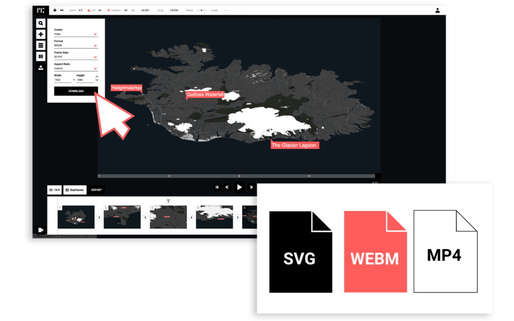
Add new keyframes, change transition time and decide the aspect ratio of your animated map with Mapcreator’s rich features. Export your map as a WEBM, PNG or JPG sequence and set the FPS according to your projects’ needs.
Create a map animation in minutes
Make elements appear or disappear on your video project. Control movements and effects from Mapcreator’s timeline. It takes the same time or even less to create an animated map as it takes to make a static image!
Highlight what matters
Use an unlimited number of annotations to highlight useful information. Zoom, scroll, and tilt on your map with extreme accuracy for any location in the world. Create the parallax effect and add impressive 3D effects.
Create a digital walk-through
Make your animated map come alive for your viewers by adding motion to its elements. Use lines and routes on your map for video to help clients visualize routes from start to destination. Add points of interest with images, videos and text for a more engaging experience.
Get Started Book a free demo Discover Animated Routes
Customize with your brand guidelines
Create an animation that matches your brand identity. Customize annotations, map style , colors and fonts that reflect your brand image. Add symbols, icons or text boxes from our large library, or let us add your own for an exclusive version of Mapcreator.

Create animated maps for broadcasts
Choose everything from transitions to camera angles to create captivating map videos for broadcasting. Make your video maps look great on TV screens with the right resolution – HD, 4K or even 8K. Use guidelines for a broadcast map to keep your TV audience engaged.
Get Started Book a free demo Go to Maps for broadcast page
Eager to create your first animated map?
Ready to take your maps to the next level and bring them to life? Contact the Mapcreator team for a free demo. Prepare to enjoy the animated map features and all the other exciting features Mapcreator has to offer.
- Book a free demo
How to make an animated map?
No more hassle and complex coding lines! Creating your animated map with an intuitive animated map maker is now possible with three simple steps:

Sign Up Today
Click on a few buttons to create your first animated map online with a unique design and style.
Sign Up Here Book a free demo

Leverage the Power of Animation
Turn your static maps into dynamic ones with our animated map maker. Add personalized details and custom animations to make the map more attractive and engaging.
Try it Now Book a free demo

Share & Enjoy Your Masterpiece
See, that’s all it takes to stand out from the crowd! Export your animated map in .WEB format and share on any platform you like.
Create your first animated map now Book a free demo
Maps made with Mapcreator

See what our clients have to say

One of our graphics teams used to dedicate one day of the week just to create maps. They now deal with map requests on the fly and are getting a consistent style across all their work.

Mapcreator really makes our daily life in the newspaper production easier!

One thing I do need to point out: Your service is excellent! Super-fast, competent and really friendly! ?

Since our team started using Mapcreator, we’ve been able to produce maps more quickly. We find the software very efficient and easy to use. The team at Mapcreator is always quick to respond to requests and they constantly strive to improve their tools for us. Their level of service is superior.
Frequently asked questions
Can i try mapcreator for free.
Seeing is believing. We offer you 14 days of free access to our online mapping tool so that you can get to know the basic mapping functionalities you can expect. Register here to get started! Want to try out Mapcreator to its full extent? Contact us and take advantage of a free ‘guided demo’ where we’ll show you the full potential and features of Mapcreator mapping software.
Do I need technical/graphical knowledge to create maps?
Mapcreator has a user-friendly interface that does not require in-depth technical and graphical skills. To make sure that you get the most out of the mapping tool, we offer full training with all our subscriptions.
Can I make maps both for print and online publishing?
The mapping tool offers the possibility to export different file formats that can be used for both print and digital publications, including interactive elements. You can create a map and export/download it as various output types. The download options we support at the moment are: .PNG, .SVG, .PDF (CMYK), EPS and WEB. WEB means you’ll get a link to the (interactive) map as well as an iframe.
How do I customize my maps with Mapcreator?
Mapcreator comes with a wide range of carefully designed default map styles, fonts, and features. In addition to the standard style elements that come with Mapcreator, map colors, features, and fonts can easily be customized for you. Do you want us to custom build your own complete map design? Please contact us , and we’ll discuss your specific needs.
Mapcreator Headquarters Bogert 31-36 5612 LX Eindhoven The Netherlands Tel: +31(0)40-264 5120
Mapcreator USA 300 Delaware ave. #210 Wilmington DE 19801 United States Tel: +1 877-778-8635
- Product Tour
- Industries we serve
- Broadcasting & Medias
- Real estate
- Direct Marketing
- Get in touch
Copyright © Mapcreator — All rights reserved — Terms of Service — Privacy Policy
How to make an animated travel map?
How to Make Travel Map Animation Step by Step

Had a wonderful trip and now want to recap your travel memories and share them with your friends, family, and subscribers? Or, perhaps, you want to map out all the locations you plan to visit during your upcoming journey? Whatever the case, there is a creative solution to put your vacation photos to use - create an animated travel map!
In this article, we’ll show you how to make travel map animation on your PC using a convenient slideshow maker. Also, you will watch a sample video for inspiration. Finally, you’ll learn alternative ways of creating travel animations to map out your remarkable journeys.
The first software we’re going to use to create a travel animation video is SmartSHOW 3D. It’s equipped with a special Travel Map effect suite that helps create interactive maps with photos from every location. Also, the program helps add voice comments and accompany your video with music. Besides, it offers 700+ effects and slideshow templates to make a memorable animation video. SmartSHOW 3D comes with a free trial, so you can check whether it’s suitable for you paying nothing. Let’s see what the program offers you in terms of travel map animation!
Step 1. Download and Run the Program
First, install SmartSHOW 3D on your computer. Click the button below and start your free trial.
Step 2. Create Your Travel Project
Once you open the program, click New Project. Switch to the Effect tab and in the Motion section, pick the Travel Map animation effect. Hit Create Map in the preview window to design your trip project. In the inclusive library of this animated maps software, you will discover a lot of stylish map designs - from retro pirate to modern illustrated. If you don’t find the map of the location you need, you can look it up on the Internet and upload it into the program. What’s more, you can resize the chosen map if you want a closeup of a particular place on it.

Step 3. Draw Your Route
Now it’s time to create the route of your trip. Think about the places you have visited and double-click on the locations to add map markers in the corresponding order. You can add as many of them as you want. Hit Next to move on to map customization.

Step 4. Create Your Animated Travel Map
At this stage, you’re going to work on animation. Select map markers individually and clip the corresponding photos from your trip to them. Adjust the Animation settings for each of the destination points to provide the viewer with sufficient time to observe your photos. Choose the marker image that suits the map style. Hit Next and select the vehicle and the route images. Hit Done to generate your travel animation.

Step 5. Review Your Animation and Edit It
Click the Play button on the preview window to watch your travel map video. If you want to make adjustments, click the Edit Slide button and double-click the Travel Map layer. Here you can work on your animated map further - for instance, rescale the animated elements of the map. Want to make your video more interactive? Use the Sounds tab of the Edit Slide menu to accompany your map with music from the built-in library of 250+ royalty-free soundtracks of the animated map creator. Alternatively, upload a tune from your PC.

Step 6. Save Your Travel Map
When you’re done with the editing process, export your animated travel map for a video project or use it solely. Just click the Create Video button in the upper right corner of your play screen. The program has over 15 export options to choose from, whether you are planning to watch your animation on a smartphone, PC, or a bigger screen.

It takes just a few clicks and your imagination to make a fascinating animation of your trip with SmartSHOW 3D. Prefer watching videos for learning new techniques? Check out our video guide on how to make an animated travel map with little effort and see what results you can achieve.

Looks cool, doesn’t it? Just imagine, you can create similar animated maps and it won’t take you hours of work. Just pack your photos and a joyful mood and put together all your travel memories with SmartSHOW 3D. Why not start now? Just click the button below and get a free trial version.
Now you can recap your travel memories and make your own travel map with ease!
Create Travel Map Animation: 3 Alternative Ways
SmartSHOW 3D is suitable for users of any skill level in slideshow making. If for some reason it’s not what you’re looking for, or the software is not compatible with your device, we’ve prepared 3 alternative animated map makers worthy of your attention.
Whether you don’t want to download extra programs, Travellerspoint will be a brilliant solution. This web-based app allows you to add photos and dates to each location on the map and shows how many kilometers you’ve traveled from destination to destination. But you have to become a supporting member to save your maps as PNGs and block ads within the editor. In the free plan, you’ll only be able to map out your journey.
If you’re looking for more options available for free, then PictraMap is the right choice. This is an online tool that helps make detailed animated road maps. It offers diverse customization options: music themes, pins, and maps. However, unless you buy a subscription, you can add only 10 locations and make only 2 projects inside this editor. Still, you can change the map style and the marker images for free.

Prefer using your smartphone to create travel content? There is an interactive travel map animation creator for you - Tripline . This app is available for both Apple and Android smartphones and has simple yet efficient features to draw routes of your trips. With this editor, you can add your photos to every destination marker and make your map more interactive. Then, you can easily share your memorable travel animation online. But this app is not as inclusive - you can’t change the marker and map designs. It’s suitable for planning your next trips or making minimalistic Insta stories rather than creating travel movies for big projects.
Now you know how to make an animated travel map in 4 different ways and can design your own in a couple of clicks. There are various online options that can help you share your travel memories. But if you want the process to be fun and easy, consider SmartSHOW 3D. This program is packed with dedicated tools and features to help you create live images, make exciting presentations, and design animated slideshows with photos. So building your new traveling animation and completing many other tasks related to producing slideshows and videos won’t take much time and effort if you use this software.

Urban Adventure
Home » Travel » How to Make an Animated Map for a Travel Video

How to Make an Animated Map for a Travel Video
Creating an animated travel map is a great way to add a personal touch to a travel video. There are two main ways to create an animated travel map: using a mobile travel map app or a desktop animated travel map maker . In this article, we will explore both methods and provide step-by-step instructions on how to make an animated travel map. Both methods will allow you to create captivating animated maps that will elevate your travel videos to the next level. Now let’s get started and see which way suits you better.
Way 1. Creating an Animated Travel Map with a Mobile App
Way 2. making an animated travel map with a desktop program, tips to make an animated map, wrapping up .

One of the easiest ways to create an animated travel map is by using a mobile travel map app. There are lots of apps available on the Internet that allow you to create custom travel maps with animations on the go. Here are the steps to create an animated travel map using Travel Video Map Maker Boast, a mobile app for Android devices.
- Download and install the animated map maker on your phone.
- Open the mobile app and select the start point and destination for your travel map.
- Click on the play button to see the final result and correct the map animation if necessary.
- Customize your map by adding markers, text, and images, adjusting the speed, and picking flag icons.
- Edit the path by tapping on the points that you want to adjust.
- Preview the video and save it in your phone gallery.
As you can see, creating an animated map for a travel video is not that difficult. However, this app is only available for Android smartphones. Besides, there are in-app purchases, and the program has limitations in terms of functionality and export options.
Need more customization options and prefer working on creative projects on a computer? Then make sure to check out the method below to learn more about creating travel map animation on a PC.

If you want more control over the map editing process, you can use a desktop animated travel map maker. This method lets you create map animation with more customization options and save your travel video in the best quality using 30+ export formats. This is how you can create an animated travel map with SmartSHOW 3D, a beginner-friendly desktop slideshow maker with a map animation feature.
- Download and launch the software after installation.
- Pick a map image you’re going to animate.
- Draw the desired route on the map by clicking on the necessary locations.
- Personalize the animation by selecting markers, adding photos, adjusting the pauses and speed, etc.
- Export the video in the file format you need. Save it for playing on mobile devices, burn it to DVD, prepare the video for posting on social media, and more.
This software is rich in features, so you can get the most out of it and create a movie-like travel video. For example, you can use 200+ royalty-free music tracks, transitions, pan and zoom effects, and filters. SmartSHOW 3D also lets you record audio comments, add text captions, create photo collages, and more.
When it comes to creating an animated travel map, there are a few key recommendations to keep in mind. After you choose the right software or app that suits your needs and skill level, you need to carefully select your destinations and plan the flow of your animation. You can adjust the pacing and add transitions to make the clip more appealing and engaging. It’s also essential to pay attention to the details: add markers, labels, and icons to highlight key points of the demonstrated route.
While editing your map animation, don’t be afraid to experiment and think creatively. Play around with different animation techniques, colors, and soundtracks to add a personal touch to your map. Remember, the goal is to create a travel map video that captivates your audience and helps you reflect on your past adventures.
Creating an animated travel map is a great way to engage your viewers and enhance the storytelling in your travel videos. In this article, we have shown you 2 ways to make an animated travel map.
First, you have learnt how to work on your project on the go by using a mobile app. Then you’ve found out how to create map animation on a computer with an intuitive program. Whether you choose to use a mobile travel map app or a desktop animated map maker, the process is quite simple and can be done by beginners and professionals alike.
Now it’s time to choose one of the programs and create a travel video that will impress everyone. So, unleash your creativity and let your animated travel maps guide your viewers on an unforgettable journey.
Related Posts

The Secret Stars of NYC’s Skyline

Top 5 must see attractions in Barcelona

Understanding the Significance of the Receipt Number for US Visa Applications
Leave a Comment Cancel reply
Inspirationfeed
Inspiring and educating bright minds.
How to Create Stunning Travel Map Animation

Last Updated on February 27, 2024
Table of Contents
Have you just had a great trip and want to share and relive some of those memories with your family, friends, or subscribers? Maybe you want to map out all of the places that you’re going to visit on your next vacation? Either way, there’s a creative way to show off your travel adventures by generating a map animation!
What is an Animated Travel Map?
An animated travel map usually appears as a video in which your favorite moments from a trip (landmarks you visited, places you went, foods you tried, etc.) are attached to a map in the background. It also typically has animated pathways, vehicle icons, and other travel-related content.
How to Create an Animated Map: A Step-by-Step Guide
In this post, you will find out how to make an animated travel map on your computer. For this purpose, we will be using SmartSHOW 3D, a slideshow and animated map maker. It comes with a user-friendly drag&drop workflow, dozens of handy features, a built-in music library, over 700 design templates & effects, and much more. Without further ado, let’s get started!
Step 1. Gather Your Travel Photos

First things first, you will need a collection of your travel photos or pictures of places you plan to visit. Organize them in a folder on your computer so that they are easily accessible. Make sure you have a good variety of images from different locations to make your map more interesting.
Step 2. Download the Program
Now, you need to install SmartSHOW 3D on your computer. You can find the software’s installation package on the official website. Just follow the instructions of the installation wizard. Then launch the program and create a blank project to begin.
Step 3. Create an Animated Travel Map

Go to the Effects tab and choose Travel Map. In the window that pops up, pick a map from the built-in collection of over 40 countries and regions, or upload the one you need using the From File button. Use your mouse wheel to change the map scale if necessary, and hit Next. Build your route by double-clicking the map and adding markers.
Step 4. Customize Your Map

Now it’s time to add your travel photos to the project and play with animations. Pair each marker with a matching location photo. When the vehicle icon reaches the marker, the image will appear next to the marker. You can also customize the route image and the vehicle – a car, bus, plane, train, or boat. Depending on the distance to each location, you can adjust your vehicle speed to make it more realistic. You can also improve the look of your map by changing the design of the marker icons.
Step 5. Make Final Adjustments

Now, it’s time to check your creation in the preview window. Click the Edit Slide button if you’d like to change something a little bit. Here you can make your travel map more immersive by adding sound effects, such as the noise of a train, a plane, or a camera shutter. Just go to the Sounds tab and explore the Audio Collection. Alternatively, you can spice things up with over 200 royalty-free music tracks from the built-in library via the Music tab.
Step 6. Export Your Project

Once everything looks amazing, it’s time to share your creation with friends and family . Click the Create Video button and select the video quality you want and the file format you need from over 30 available options. You can upload it to social media platforms like YouTube, Facebook, and Instagram, burn it onto a DVD, or simply save it on your computer for future enjoyment.
Now you know that creating animated travel maps is a fun way to relive your travel memories . So why wait? Start creating your own map animation today and let your adventures unfold in a dynamic and engaging way! Just follow the steps above and get an exciting video that captures the essence of your adventures. If you want to find out more about travel map animation , check out the article via the link.

Posted by: Igor Ovsyannnykov
Igor is an SEO specialist, designer, photographer, writer and music producer. He believes that knowledge can change the world and be used to inspire and empower young people to build the life of their dreams. When he is not writing in his favorite coffee shop, Igor spends most of his time reading books, taking photos, producing house music, and learning about cinematography. He is a sucker for good coffee, Indian food, and video games.
- Google Earth
- Earth Engine
- Earth Outreach
Let the world tell your story
Earth Studio is an animation tool for Google Earth’s satellite and 3D imagery.
Inside Earth Studio
Powerful motion design, all in the browser. Earth Studio gives you the tools you need to create professional content with Google Earth imagery. Read more in the Documentation .
Keyframe Animation
Earth Studio uses keyframes, just like other industry-standard animation tools. Move the globe, set a keyframe, rinse and repeat. It’s that easy.
Quick-Start Projects
Create an orbit, or fly from point to point. Select from up to five templates to get started - no animation experience needed.
Animatable Effects
Animate custom attributes such as the sun's position, the camera's field of view and more.
3D Camera Export
Easily add map labels and pins in post production. Earth Studio supports camera export to Adobe After Effects.
Try the Earth Studio preview
Earth Studio is free to use and works with the desktop version of Google Chrome. Sign in with your Google account to request access. Learn more
Earth Studio works with the desktop version of Google Chrome. Sign in with your Google account to request access. Learn more .
Where Your Travel Memories Come to Life
New to PictraMap? Start Here!

We are Diana and Jordan - Co-Founders of PictraMap®
If you are a passionate traveler, addicted to your camera and often accused of boring your friends to death with travel photos and endless stories about your adventures, you’ve come to the right place!
We'll help you WOW your friends ツ
Visual stories draw eyeballs, everybody knows that. Your animated travel maps will make your friends want to hear about your adventures. They might even (quietly) envy you.
If right about now you start feeling bad about showing off, don’t. Look at it this way – you are not bragging about your cool life; you are inspiring your friends to change theirs. 😉
Join our community today
Sign-up to stay in touch and get updates from us as we travel across counties, experience new cultures, and discover fun things to do. We love being digital nomads and we want to go on this journey with YOU . Join us!
What passionate travelers say about PictraMap®

I was pleasantly surprised of what I saw when a friend shared the link to PictraMap. The unique way I can create and share my albums there lets my friends and family enjoy the fun moments of my trips. I like the flexibility and variety of the maps, the transitions between locations, and the music scores I can choose from – all in a very quick and intuitive way. Thank you, guys!

What a great way to give life to my countless otherwise boring photos! The maps, the music, the colors make every album special and help add an emotion to it. It's easy to use and the result is a fun adventure I could share with all my friends and family! I know they will love it too!!
Browse Site
- Start Here!
- Plans & Pricing
- Log in to PictraMap
- Create an account
From The Blog
- Convert PictraMap Animations to Videos: Built-in Feature Released
- Search by GPS Coordinates, Full HD Pics and New Maps Released
- New Customization Options Now Available in the ‘Extras’ Tab
Get in Touch
Want updates via email.
Press ESC to close

How To Make Travel Map Animation – An Easy Guide
What are the benefits of a travel map animation.
- To showcase travel experiences: A visual depiction of the locations visited can be given using animated travel maps when showcasing travel experiences.
- To make travel videos more engaging: By displaying the movement or development of details across time or space, animated trip maps can add visual interest and engagement to travel movies.
- To create a sense of journey: Animated travel maps can provide a more immersive experience by giving viewers a sense of the path taken.
An Easy Guide To Travel Map Creation
1. get the software, 2. create your travel project.

3. Draw Your Route

4. Build Your Travel Map

5. Check And Save Your Creation

Leave a Reply Cancel reply
Animated Maps
Start creating your animated maps for FREE and enjoy a 25% discount on our commercial GEOLayers.app plans for early birds.
Become an Early Adopter
Create stunning animated maps direcly in your Browser!
Design, Create, Animate and Share Maps - All in one place! GEOlayers.app lets you create animated maps in a breeze!
Unlock your imagination: effortlessly select colors, design harmonious basemaps, create outstanding labels, and more! Seamlessly animate with our item-based timeline - Say goodbye to fiddly keyframes and value graphs.
GEOlayers.app offers all the tools you need to tell your story with a map!
Try GEOLayers.app now for free!

Adjust colors, basemaps, labels and styles.
Design Maps
GEOlayers.app helps you with colors, basemaps, labels and styles to highlight features on your animated maps.
Design your first animated map

Create animated maps directly in your browser!
Create Maps
Create animated maps of any place in the world, highlight features, add Labels, place Icon Markers or even draw directly to your map. Possibilities are endless!
Create your first animated map

Item based timeline - no keyframes needed!
Animate Maps
Our item based timeline lets you create smooth animated maps and transitions in no time. It can handle automatic animations like flashing features or rotating 3D viewports while giving you all the control you need.
Animate your first map

Render presets for different use-cases availbale
Render Images and Videos of your animated maps in all formats and resolutions you need! Export the same animation as an easy to share MP4 file for social media or lossless 4K image sequence for further editing, all with one click!
Render and Share your first animated map
If you need more...
... please have a look at our Adobe After Effects Extension GEOLayers 3. It gives you even more control and creative freedom to animate maps leveraging the power of Adobe After Effects. Check it out on aescripts.com

follow us on social media

The Future of Creativity

Blockbuster After Effects Templates
- License Comparison
- Broadcasting & Production
- Education & eLearning
- Media Organizations
- Marketing Teams
- Creative Agencies
- Storyblocks API
- Resource Center
- Social Media Tutorials
- Compare To Other Solutions
- Storyblocks Series
- Visit the blog
Travel Map Animation Templates Royalty-Free
Royalty-free templates, template type, media details, usage rights, ( 520 results found for travel map animation ), travel map icons pack, summer dynamic opener, fire logo reveal, corporate lower thirds, clean corporate titles, location icons for davinci resolve, fantasy slide show, photo slide show, modern dynamic titles, gradient lower thirds, interface pack for premiere pro, fast summer opener, broadcast news package, elipses slides | premiere pro mogrt, wedding happiness, detective lower thirds, watercolor opener, dynamic lower thirds, location titles 4.0 | davinci resolve macro, wedding opener package, cartoon scribble titles, adventure titles pack, icons & buttons pack of 'sketchy' kit. bundle 95 elements, social icons, youtube buttons, ae cs5 template: history video tour, modern clean titles, fast elegant titles, stunning photo montage, pr: rhythmic opener, comic superhero, luxury elegant titles, rhythm lower thirds, newspaper show opener, falling polaroid photos, 21 instagram stories, newspaper opener, cinematic opener, pr: fast slideshow, minimal call outs, comic action opener, urban glitch promo, polaroid photo slideshow, pictures logo reveal, epic opener package, auto scale titles, dynamic elegant titles, parallax slideshow - 3 versions.
- Solar Eclipse 2024
See the 2024 Solar Eclipse’s Path of Totality
A total solar eclipse is expected to pass through the United States on April 8, 2024, giving stargazers across the country the opportunity to view the celestial phenomenon in which the sun is completely covered by the moon.
The eclipse will enter the U.S. in Texas and exit in Maine. It is the last time a total solar eclipse will be visible in the contiguous United States until 2044.
Here's what to know about the path of the eclipse and where you can see it.
Read More : How Animals and Nature React to an Eclipse
Where can you see the total solar eclipse?
The eclipse will cross through North America, passing over parts of Mexico, the United States, and Canada.
The eclipse will enter the United States in Texas, and travel through Oklahoma, Arkansas, Missouri, Illinois, Kentucky, Indiana, Ohio, Pennsylvania, New York, Vermont, New Hampshire, and Maine. Small parts of Tennessee and Michigan will also experience the total solar eclipse.
Much of the eclipse's visibility depends on the weather. A cloudy day could prevent visitors from seeing the spectacle altogether.

When does the solar eclipse start and end?
The solar eclipse will begin in Mexico’s Pacific coast at around 11:07 a.m. PDT. It will exit continental North America on the Atlantic coast of Newfoundland, Canada, at 5:16 p.m. NDT.
The longest duration of totality—which is when the moon completely covers the sun — will be 4 minutes, 28 seconds, near Torreón, Mexico. Most places along the path of totality will see a totality duration between 3.5 and 4 minutes.
Read More : The Eclipse Could Bring $1.5 Billion Into States on the Path of Totality
Where’s the best place to see the total solar eclipse?
The best place to witness the event is along the path of totality. Thirteen states will be along the path of totality, and many towns across the country are preparing for the deluge of visitors— planning eclipse watch parties and events in the days leading up to totality.
In Rochester, NY, the Rochester Museum and Science Center is hosting a multi-day festival that includes a range of events and activities. Russellville, Arkansas will host an event with activities including live music, science presentations, tethered hot-air balloon rides, and telescope viewings.
More Must-Reads From TIME
- Exclusive: Google Workers Revolt Over $1.2 Billion Contract With Israel
- Jane Fonda Champions Climate Action for Every Generation
- Stop Looking for Your Forever Home
- The Sympathizer Counters 50 Years of Hollywood Vietnam War Narratives
- The Bliss of Seeing the Eclipse From Cleveland
- Hormonal Birth Control Doesn’t Deserve Its Bad Reputation
- The Best TV Shows to Watch on Peacock
- Want Weekly Recs on What to Watch, Read, and More? Sign Up for Worth Your Time
Write to Simmone Shah at [email protected]
See the Total Solar Eclipse’s Shadow From Space
Satellite images from NASA and NOAA showed the moon’s shadow moving across North America.
By K.K. Rebecca Lai and William B. Davis
PATH OF TOTALITY
UNITED STATES
- Share full article
Advertisement
When and where the solar eclipse will be crossing the U.S.

A total solar eclipse will grace the skies over North America on Monday, one of the most hotly anticipated sky-watching events in recent years.
Weather permitting , millions of people in Mexico, 15 U.S. states and eastern Canada will have the chance to see the moon slip between Earth and sun, temporarily blocking the sun’s light .
The total solar eclipse will be visible along a “path of totality” that measures more than 100 miles wide and extends across the continent. Along that path, the moon will fully obscure the sun, causing afternoon skies to darken for a few minutes.
Follow live updates on the solar eclipse
In all other parts of the continental U.S., a partial solar eclipse will be visible, with the moon appearing to take a bite out of the sun. Exactly how big a bite depends on the location.
The first spot in North America that will experience totality on Monday is on Mexico’s Pacific coast at around 11:07 a.m. PT, according to NASA .
After moving northeast across Mexico, the eclipse’s path travels through Texas, Oklahoma, Arkansas, Missouri, Illinois, Kentucky, Indiana, Ohio, Pennsylvania, New York, Vermont, New Hampshire and Maine. Slivers of Michigan and Tennessee will also be able to witness totality if conditions are clear.
In Canada, the eclipse will be visible in parts of southern Ontario, Quebec, New Brunswick, Prince Edward Island and Cape Breton, at the eastern end of Nova Scotia.
The timing of the eclipse and the duration of totality varies by location. Most places will experience around 2 minutes of darkness, but the longest periods of totality are typically in the center of the eclipse’s path.
This year, the longest stretch of totality will last 4 minutes and 28 seconds in an area northwest of Torreón, Mexico.

Below is a list of timings for some U.S. cities along the path of totality, according to NASA .
- Dallas: Partial eclipse begins at 12:23 p.m. CT and totality at 1:40 p.m. CT.
- Idabel, Oklahoma: Partial eclipse begins at 12:28 p.m. CT and totality at 1:45 p.m. CT.
- Little Rock, Arkansas: Partial eclipse begins at 12:33 p.m. CT and totality at 1:51 p.m. CT.
- Poplar Bluff, Missouri: Partial eclipse begins at 12:39 p.m. CT and totality at 1:56 p.m. CT.
- Paducah, Kentucky: Partial eclipse begins at 12:42 p.m. CT and totality at 2:00 p.m. CT.
- Carbondale, Illinois: Partial eclipse begins at 12:42 p.m. CT and totality at 1:59 p.m. CT.
- Evansville, Indiana: Partial eclipse begins at 12:45 p.m. CT and totality at 2:02 p.m. CT.
- Cleveland: Partial eclipse begins at 1:59 p.m. ET and totality at 3:13 p.m.
- Erie, Pennsylvania: Partial eclipse begins at 2:02 p.m. ET and totality at 3:16 p.m. ET.
- Buffalo, New York: Partial eclipse begins at 2:04 p.m. ET and totality at 3:18 p.m.
- Burlington, Vermont: Partial eclipse begins at 2:14 p.m. ET and totality at 3:26 p.m. ET.
- Lancaster, New Hampshire: Partial eclipse begins at 2:16 p.m. ET and totality at 3:27 p.m.
- Caribou, Maine: Partial eclipse begins at 2:22 p.m. ET and totality at 3:32 p.m. ET.
Other resources can also help you figure out when the various phases of the eclipse will be visible where you live, including NationalEclipse.com and TimeandDate.com .
If you plan to watch the celestial event, remember that it’s never safe to look directly at the sun, including through binoculars, telescopes or camera lenses. Special eclipse glasses are required to safely view solar eclipses and prevent permanent eye damage.
Denise Chow is a reporter for NBC News Science focused on general science and climate change.
- International
Total solar eclipse 2024
By Ashley Strickland , Elise Hammond , Maureen Chowdhury , Antoinette Radford, Eric Zerkel and Aditi Sangal , CNN
In pictures: Watching the solar eclipse across North America
From CNN Digital’s Photo Team

Click here for more spectacular photos from today's eclipse.
Why eclipses create a "beautiful coincidence" on Earth
From CNN's Ashley Strickland
Americans are a little spoiled when it comes to eclipses. After all, we just experienced one that the majority of the country got to see, and it comes on the heels of the "Great American Eclipse" that tracked from Oregon to South Carolina in 2017.
But that doesn't often happen. And it won't again until the 2040s.
On average, an eclipse occurs in the same place every 375 years, said Dr. John Mulchaey, Carnegie Institution for Science’s deputy for science and the director and Crawford H. Greenewalt Chair of the Carnegie Observatories.
And we’re living at the right time to truly enjoy the sight of a total eclipse on Earth, he said.
While eclipses occur throughout the solar system, none are exactly like the ones experienced in our world.
The moon is about 400 times smaller than the sun, but the moon is also about 400 times closer to Earth than the sun is, creating a “beautiful coincidence” that results in eclipses when the three celestial bodies align, Mulchaey said.
This alignment is called syzygy, or when three objects line up in space.
In the distant past, the moon was much closer to Earth, which means totality likely didn’t appear as it does now. And within another 60 million years or so, the moon will be so far away that it will never cover the sun, making this a rare moment in time, Mulchaey said.
The long history of myths and folklore inspired by eclipses
From CNN's Ashley Strickland and Terry Ward

Eclipses have long inspired terror and awe as ancient cultures sought ways to explain the celestial phenomenon .
“I find the mythology and folklore of eclipses fascinating,” said Mark Littman, a journalism professor at the University of Tennessee in Knoxville and coauthor of “ Totality: The Great North American Eclipse of 2024 .”
“To see how people long ago and people today reacted to a total eclipse of the Sun, a sight so unexpected, so dramatic, so surprising in appearance, and so unnatural even though it is utterly natural.”
Ancient records of eclipses date back to 772 BC, when the Chinese marked them on animal bones, and 750 BC, when Babylonians recorded eclipses in their cuneiform writing on clay tablets, Littmann said. Both cultures "realized there was a rhythm to eclipses," which meant they could be calculated and predicted in the future.
Despite the ability to predict eclipses, the cause of the eclipse remained unknown, so myths and folklore filled the knowledge gap.
"The mythology of eclipses most often involves a beast that tries to eat the sun for lunch. For the Chinese, that beast was a dragon or a dog. For Scandinavians, it was a wolf," Littmann said.
Those in northern South America thought the sun and moon fought one another, trying to shut off each other's light, he said.
Transylvanian folklore suggested that the sun looked down on Earth, saw the corruption of humans, and turned away in disgust.
And the Fon people of western Africa thought the male sun ruled the day, while the female moon ruled the night.
"They love each other, but they are so busy traversing the sky and providing light that they seldom get together," Littmann said. "Yet when they do, they modestly turn off the light."
Eclipses provide unique opportunities for NASA scientists to learn more about the future of the sun
From CNN's Elise Hammond

NASA scientists took full advantage of Monday’s eclipse to collect data and study the Earth, moon and sun in different ways, the agency’s deputy administrator said. One area of specific interest is the sun’s corona , or outer atmosphere.
“This is a very elusive region and it can be viewed during a solar eclipse in a very special way,” Pam Melroy said during a news conference at the end of March .
She said understanding the corona is “key to understanding fundamental questions about how heat and energy are transferred out into the solar wind,” which contributes to how solar wind and flares impacts Earth.
“Things are happening with the corona (that) we don’t fully understand and the eclipse gives us a unique opportunity to collect data that may give insights into the future of our star,” Melroy said.
And this is an especially good year to study the corona, she said. The sun is approaching solar maximum — the peak of activity — later this year, and scientists are eager to capture this moment through a variety of observations that can only occur during eclipses. During solar maximum, the sun’s magnetic poles flip and then the sun will grow quiet again during a solar minimum.
“The chance that we are going to see something amazing is very high,” Melroy said.
Former NASA astronaut says she hopes eclipse sparks sense of connectedness with the universe
A former NASA astronaut said she hopes Monday’s total solar eclipse inspires a connection between everyone who witnessed it and the universe.
“We’re all part of this universe – and the universe was showing us some of its secrets at that point in time,” Mae Jemison told CNN.
While viewing totality in Bloomington, Indiana, the former astronaut said she was thinking about other times she experienced eclipses.
When she saw a partial eclipse as a child in Chicago, Jemison said she was trying to make sense of what was happening.
But then thinking about her time as an astronaut, “it reinforced the feeling that when I look up, when I look away from the Earth when I was in space, it again connects me with this world, with this universe – and know that I have a responsibility.”
Jemison said science is about building on knowledge for the next generation, and the eclipse was an opportunity to do just that. Scientists used Monday’s eclipse to gather data to better understand the sun but Jemison said she hopes there is also learning at a personal level.
“I hope what people discover is themselves and their connectedness to the rest of the universe,” she said.
Eclipse Explained: Is there anywhere that saw totality in both 2017 and 2024?

Yes! There is an area where both 2017 and 2024 paths of totality intersect. According to a map from NASA , that area includes parts of Missouri, southern Illinois and western Kentucky.
One of the places in that intersection, Carbondale, Illinois, experienced the longest period of totality in 2017 at 2 minutes, 42 seconds, according to NASA.
Seeing the eclipse again more than 20 years later
From CNN's Christina Zdanowicz

Juan M. Soto Peña and his wife experienced the joy of a total solar eclipse alongside their daughter, Luciana, in Tucson, Arizona.
The couple saw a partial solar eclipse together on December 25, 2000, in the state of Sonora in Mexico, he said.
Worried about eye damage? Here are the signs you should visit an optometrist after the eclipse

Maybe your eclipse glasses were fake. Perhaps you forgot to slip them back on as the first bit of sunlight reappeared after totality. Or you noticed your child, friend or family member looking up at the sun without putting on their glasses.
Symptoms of eye damage after improperly viewing the eclipse without proper protection can take hours or days to manifest. They include loss of central vision, altered color vision or distorted vision .
And if you notice any symptoms or experience eye discomfort, make an appointment immediately using the American Optometric Association's doctor locator , said Ronald Benner, an optometrist and president of the American Optometric Association.
“For most people, it’s an alteration of color vision,” Benner said. “The next morning, colors just don’t look right, or it may be bleached out it or just kind of hazy all the time. For others, it may be that they actually have holes in their vision.”
If the damage occurs in the center of someone’s vision, it can affect the ability to read or recognize faces, Benner said.
Here's what the eclipse looked like from the International Space Station
From CNN's Taylor Nicioli

From space, crew members at the International Space Station saw a different perspective of the celestial event — the moon’s shadow cast onto Earth.
The orbiting laboratory "soared into the moon’s shadow" and NASA Flight Engineers Matthew Dominick and Jeanette Epps got a chance to capture it following their “workday filled with cargo transfers, spacesuit maintenance, and microgravity research,” according to a statement from NASA . The astronauts took pictures and videos of the shadow of the moon as seen from their position about 260 miles above southeastern Canada.
Please enable JavaScript for a better experience.
IMAGES
VIDEO
COMMENTS
Create animated maps for video. Free animated map maker. Create animated maps for video. Free animated map maker. We use cookies to improve our service. Learn more → . Export. It may take few seconds to render ...
If you're too busy to create your first animated travel map right now, or you think your friends can wait being WOW-ed by your last amazing trip, join our community. We'll remind you later that your travel photos can still get the attention they deserve. Keep me posted. Create your animated travel map within minutes with PictraMap - a free ...
SmartSHOW 3D - A tool for granular controls. For users who wish to have a bit of granular control for creating an animated travel route map, they can download the SmartSHOW 3D software. There is ...
In this tutorial, we'll show you how to create a dynamic, interactive, and animated travel map for your travel and other videos using free tools. This power...
Create without limits with a subscription to https://elements.envato.com/?utm_campaign=elements_social_eyt_E2cb0-7bpJg&utm_medium=social&utm_source=YouTube&u...
Method 1 Make Animated Travel Map Videos with Location Video Maker. The entire process of creating an animated travel map video in Wondershare's Filmora is categorized into two parts, wherein the first part you will collect all the ingredients that are needed to get started, and in the second part you will actually make an animated map using the tools and features present in Filmora.
In this Canva Tutorial, we'll show you how to create stunning and dynamic travel map animation using Canva. 🚀 Whether you're a travel vlogger, content creat...
Create Memorable Animated Travel Videos. Travel Animator is your perfect travel companion, making your trips even more exciting. With our app, you can effortlessly create captivating videos to share on your social media. Take the art of storytelling to the next level by tracing your journey and transforming it into a dynamic video.
Download. Fully compatible with Windows 11, 10, 8, 7. Step 1. Pick a Map. Run this animated maps software after installation. Choose the New Project option and go to the Effects tab. Double-click on the Travel Map icon. In the window that pops up, select a map from the built-in collection, ranging from retro to modern with famous sights.
Anyone can create animated maps. Create impactful, dynamic video maps and animations in one tool and never worry about post-production. Mapcreator allows you to share, embed and broadcast animations without a hassle. Embed your animated map to your website, social media or whenever you want to use it. Create an Animated Map Now!
Free Online Travel Animation Video Maker. Elevate your travel storytelling with travel animation videos made on FlexClip's free online travel animation video maker, a game-changer in video production that saves you time and money. Be it captivating travel map animation, dynamic travel logo animation, or engaging travel video intro animation ...
First, install SmartSHOW 3D on your computer. Click the button below and start your free trial. Download free. For Windows 11, 10, 8, 7. Step 2. Create Your Travel Project. Once you open the program, click New Project. Switch to the Effect tab and in the Motion section, pick the Travel Map animation effect.
Way 1. Creating an Animated Travel Map with a Mobile App. One of the easiest ways to create an animated travel map is by using a mobile travel map app. There are lots of apps available on the Internet that allow you to create custom travel maps with animations on the go. Here are the steps to create an animated travel map using Travel Video Map ...
Create an Animated Travel Map. Go to the Effects tab and choose Travel Map. In the window that pops up, pick a map from the built-in collection of over 40 countries and regions, or upload the one you need using the From File button. Use your mouse wheel to change the map scale if necessary, and hit Next. Build your route by double-clicking the ...
Earth Studio works with the desktop version of Google Chrome. Sign in with your Google account to request access. Learn more. A web-based animation tool for Google Earth's satellite and 3D imagery.
Visual stories draw eyeballs, everybody knows that. Your animated travel maps will make your friends want to hear about your adventures. They might even (quietly) envy you. If right about now you start feeling bad about showing off, don't. Look at it this way - you are not bragging about your cool life; you are inspiring your friends to ...
To make travel videos more engaging: By displaying the movement or development of details across time or space, animated trip maps can add visual interest and engagement to travel movies. To create a sense of journey: Animated travel maps can provide a more immersive experience by giving viewers a sense of the path taken.
Buy me a coffee for personal tips & advice (link above)My Videos using travel map animations:https://youtu.be/ktaOmecRwlY - The #1 Adventure Ride Rulehttps:/...
Create animated maps of any place in the world, highlight features, add Labels, place Icon Markers or even draw directly to your map. Possibilities are endless! Create your first animated map. ... Render Images and Videos of your animated maps in all formats and resolutions you need! Export the same animation as an easy to share MP4 file for ...
World Map Video Toolkit. 300 scenes. 30K+ Exports. Flexible. Make your presentations fun and more interactive, pairing your useful info with this 3D world map. Choose any country, add your media files and text, and finish off with a smooth logo animation. Ideal for infographic projects, presentations, travel agency promos, and educational videos.
Download over 519 travel map animation royalty free Templates with a subscription. Stock Media. Video. Stock Footage. Animated Backgrounds. Templates. After Effects Templates. Premiere Pro Templates. DaVinci Resolve Templates. Apple Motion Templates. ... Produce videos faster with unlimited access to our library, directly in Premiere Pro and ...
2 minute read. Today's total solar eclipse will cut a 2,000-mile path across the United States in just over an hour, casting near darkness over a region of more than 200,000 square miles from ...
By Simmone Shah. April 1, 2024 7:00 AM EDT. A total solar eclipse is expected to pass through the United States on April 8, 2024, giving stargazers across the country the opportunity to view the ...
Satellite images from NASA and NOAA showed the moon's shadow moving across North America. By K.K. Rebecca Lai and William B. Davis CANADA Montreal PATH OF TOTALITY UNITED STATES Dallas MEXICO ...
Create Awesome Travel Animation on Google Map using TravelBoast Android / iPhone / iOS app.Android URL: https://play.google.com/store/apps/details?id=io.urob...
Timothy D. Easley / AP file. Below is a list of timings for some U.S. cities along the path of totality, according to NASA. Dallas: Partial eclipse begins at 12:23 p.m. CT and totality at 1:40 p.m ...
Today's total solar eclipse is the first widespread one in the Lower 48 states since 2017 and the last one until 2044. W e're here to help track the weather with a series of maps below, including ...
In the distant past, the moon was much closer to Earth, which means totality likely didn't appear as it does now. And within another 60 million years or so, the moon will be so far away that it ...
NASA also said in its statement, "Traveling towards the center of the path of totality — even a mile or two — will quickly increase the length of totality that people can see.". And ...