
Tour du Mont Blanc | Maps & Routes
The Tour du Mont Blanc takes trekkers through France, Italy, and Switzerland on one of the most spectacular trails in the world. Typically completed in 11 stages, the route circumnavigates Mont Blanc, the highest peak in Western Europe. This post will provide all of the TMB navigational resources you need to familiarize yourself with the route, location, and all things map-related so you can be sure you’re ready to tackle this epic adventure!
What’s in this post?
Where is the tour du mont blanc.
- Interactive Tour du Mont Blanc map
- How long is the Tour du Mont Blanc?
- What is the elevation profile of the Tour du Mont Blanc?
- Which maps should I carry?
Tour du Mont Blanc GPS/GPX
- Apps and offline mapping
- Let Us Make Your TMB Trip Success
Let us help plan your TMB
We’re here to help! We offer comprehensive TMB planning support so you can plan your perfect trip!
In addition to our popular guides, we also offer the following TMB planning services:
GPS Digital Download
GPS files for the entire TMB
Navigate with confidence on the trail
Works with all GPS navigation apps & devices
Custom GPS File
Custom GPS file created for your unique itinerary
Includes all of your accommodations
Confidently navigate using a GPS file designed just for you
Expert Consultation s
1-on-1 video calls
Specifically catered to your questions
Problem-solve your itinerary, bookings, route options, and more!
Why work with us?

As passionate hikers, we’ve made it our goal to empower you with all of the information you need to have your best TMB experience.
We’ve helped over 2,500 hikers prepare for their trips, navigate on the trail, and simplify the planning process.
The Tour du Mont Blanc is an approximately 101 mile/162 km trek that takes walkers around Mont Blanc and through France, Italy, and Switzerland. The closest major city to the TMB is Geneva, Switzerland. The route passes through seven mountain valleys (Val d’Arve, Val d’Montjoie, Vallee des Glaciers, Val Veni, Italian Val Ferret, Swiss Val Ferret, and Vallee du Trient) and is typically completed in 11 stages.
Looking for more TMB resources? Check out our Ultimate Guide to the Tour du Mont Blanc here.

The TMB is traditionally hiked in a counter-clockwise direction beginning in the French town of Les Houches, which is adjacent to Chamonix. It is also possible to walk the route in a clockwise direction, and trekkers headed this way typically start in the Swiss town of Champex.
This is a result of the steep climb out of Les Houches that would be required if you were to hike clockwise from there. Best to avoid that on your first stage!
The TMB also passes through the French towns of Les Contamines, Les Chapieux, and Tre-le-Champ, the Italian town of Courmayeur, and the Swiss towns of La Fouly and Champex, while passing near the small village of Trient.
The stages for the traditional counter-clockwise route are as follows:
- Stage 1: Les Houches to Les Contamines
- Stage 2: Les Contamines to Les Chapieux
- Stage 3: Les Chapieux to Rifugio Elisabetta
- Stage 4: Rifugio Elisabetta to Courmayeur
- Stage 5: Courmayeur to Rifugio Bonatti
- Stage 6: Rifugio Bonatti to La Fouly
- Stage 7: La Fouly to Champex
- Stage 8: Champex to Col de la Forclaz
- Stage 9: Col de la Forclaz to Tre-le-Champ
- Stage 10: Tre-le-Champ to Refuge La Flegere
- Stage 11: Refuge La Flegere to Les Houches
To help visualize these 11 stages, we created the Tour du Mont Blanc virtual fly-through video below. Give it a watch to get a sense of the route, terrain, and what you can expect!
While for many the mere mention of Mont Blanc conjures up images of the famous French mountaineering town of Chamonix, the route of the TMB does not actually go through the town, instead taking a trail high above the Chamonix Valley.
In addition to staying in mountain huts and hotels along the TMB , it is also popular to camp along the route.

In addition to the traditional route, the Tour du Mont Blanc also includes several ‘alternates’. These trails still connect the same start and finish points, but take walkers on a different route between the two points. Alternates can be used to add challenge, avoid certain sections, or lengthen/shorten a particular stage. The map below shows the common alternate routes on the TMB.
These alternate routes include the following:
- Col de Tricot : Alternate between Les Houches & Les Contamines over the stunning Col de Tricot with up close views of the Bionnassay Glacier.
- Col des Fours : Alternate route between Les Contamines (starts at Refuge du Col de la Croix du Bonhomme) and Refuge Des Mottets. Effectively cuts out Les Chapieux stop. This is a rugged and exposed alternate that is best for experienced hikers.
- Tete Bernarda : Alternate route between Courmayeur and Rifugio Bonatti. High level route that has incredible views of the Grandes Jorasses.
- Fenetre d’Arpette: Alterate route between Champex and Col de la Forclaz. Arguably the most difficult stage on the entire Tour du Mont Blanc, but with amazing views.
- Refuge Les Grands : Route that connects the Fenetre d’Arpette alternate route to the Col de Balme via an overnight stay at Refuge Les Grands.
- Le Tour: Alternate route connecting Col de Balme with the village of Le Tour. This is an easier alternate from the main TMB and drops hikers into the valley.
- Col des Montets: Alternate route from Tre-le-Champ that avoids the famed ladder section enroute to La Flegere.
- Lac Blanc: Alternate route that takes walkers to the stunning Lac Blanc and associated refuge.

Interactive Tour du Mont Blanc Map
The interactive Tour du Mont Blanc map below will allow you to zoom in on the various stages as well as view the traditional stops along the route. The map also displays the common alternate routes that are a part of the TMB. You can click on each stage to see the total length, listed in both kilometers and miles.
Get The FREE TMB Essentials Handbook

Our free PDF guide covers all the basics – when to hike, accommodation, typical costs, and more!
Your TMB Essentials Booklet will be emailed to you shortly.
How We Navigate on the Tour du Mont Blanc
If you’re interested in getting access to the GPS data used to create all of the maps in this post, we are happy to offer our Tour du Mont Blanc GPX files for sale. When you download the GPX file, you’ll get route data for each of the traditional stages of the TMB as well as all of the common alternate route, plus waypoints for each stop along the way.
If you want to learn how to use the GPS data to navigate on the trail, be sure to check out our post on How to Navigate on the Tour du Mont Blanc.

You’ll be able to load the GPX file into the mapping software or GPS phone app of your choice!
How Long is the Tour du Mont Blanc
The Tour du Mont Blanc is approximately 101 miles or 162.5 kilometers long. This is based on following the traditional route and not taking any shortcuts or alternates. Of course, few if any walkers will stick to this route exactly. You could easily walk less or more depending on your preferences, route choices, and the conditions encountered on the trail.
The maps below show the approximate distance of each stage in miles as well as kilometers. For more detail on each stage be sure to check out our interactive map in the section above!

What is the Elevation Profile of the Tour du Mont Blanc?
Over all 11 stages, the Tour du Mont Blanc has approximately 37,000 feet or 11,300 meters of elevation change! That averages out to over 3,300 feet or 1,000 meters of elevation change per stage for those who complete the walk in 11 days.
Of course, there will be days with more elevation gain and days with less. Given that the TMB is a loop trail, you’ll ascend and descend the exact same amount over the course of your trek.
The elevation profiles below, displayed in both imperial and metric units, will give you an overview of what each stage of the Tour du Mont Blanc is like in terms of total elevation change and distance. On the charts elevation is shown on the left hand side while distance is shown on the bottom. Each blue dot represents a stop along the traditional 11 stage TMB route, with the stop name shown at the top.
The steepness of the line between any two points shows the steepness of the trail for that particular stage. The distance between the two points shows the length of the the stage. So for instance you can see that the stage from Tre-le-Champ to La Flegere is rather short in distance, while the stage from Les Contamines to Les Chapieux has a lot of elevation gain.

Which Maps Should I Carry on the Tour du Mont Blanc?
The TMB is a very well marked trail with frequent signs and trail markers. As a result, when we hiked the TMB we did not rely heavily on any of the various paper maps that are available for the route. Instead, we preferred to utilize GPS maps on our phones, as described in the next section. However, that doesn’t mean we didn’t bring paper maps with us.
While technology has done a tremendous amount to make navigating while hiking easier, there is simply no replacement for carrying a physical map with you. If your phone runs out of battery or you drop it in a puddle you’ll be glad you had your handy paper maps to rely on.
We recommend bringing the IGN 3630 OT Chamonix and IGN 3531 ET St-Gervais with you, as they provide a detailed view of the TMB route. There is also a single IGN map that covers the entire route , although at a less detailed scale. The table below has an overview of all of the options:

If you want to learn how to use the GPS data to navigate on the trail, be sure to check out our post on How to Navigate on the Tour du Mont Blanc.

You’ll be able to load the GPX file into the mapping software or GPS phone app of your choice!
Tour du Mont Blanc map app/offline mapping
As mentioned above we utilized offline downloadable GPS maps on our smartphones to navigate while hiking the TMB. This is a great way to navigate on the trail as it allows you to see your progress for the day and also isn’t reliant on a cell phone signal to display the map. Our How to Navigate on the TMB post has all the information you need to get set up using an app for your Tour du Mont Blanc map. This step-by-step article will teach you how to quickly and easily turn your phone into a GPS device.
Want more Tour du Mont Blanc content?
- Guide to Camping on the Tour du Mont Blanc
- TMB Packing List
- 10 Essentials for the Tour du Mont Blanc
- How to navigate on the Tour du Mont Blanc
- How to find all of your campgrounds on the TMB
- How to train for the Tour of Mont Blanc
- How to hike the TMB for (nearly) free
- TMB Trip Report
- TMB Photo Gallery
- Tour du Mont Blanc Logistics
- How Much it Cost us to Hike the TMB
- Tour du Mont Blanc Accommodation and Refuge Guide
- Tour du Mont Blanc – Shortcuts, Detours, & Public Transit
4 thoughts on “Tour du Mont Blanc | Maps & Routes”
Many thanks a lot for this article. Decided last minute to do the tour with not much time for planning and investigating info on the trek, distance, elevation, etc. This was of a great help. Thx a Lot !
Hey Veronika, So glad you’ve found the article useful! Hope you have a great TMB! Best, Ian
Most helpful site I have visited. Is there such a thing as a time map which shows the average time when walking each stage
Hey James, Glad you are finding our site useful! We don’t currently have a map showing estimated hiking times for each stage, but that is a great idea. In the meantime we do provide approximate hiking times in our Ultimate Guide to the Tour du Mont Blanc article here . Let us know if you have any other questions, Best, Ian
Leave a Comment Cancel reply

We’re Emily and Ian, outdoor lovers and planning nerds who live in Boulder, Colorado. The only thing we love more than researching and mapping out our next adventure, is actually being out there on the trail. Between the two of us, we’ve been to over 30 countries, and much of our travel in these countries has been on two feet or two wheels. When we’re not in a far-flung destination, we spend a lot of time exploring the amazing camping, hiking, and biking destinations in our home state of Colorado. Learn More About Us
Tour du Mont Blanc
West highland way, laugavegur trail, walker's haute route, coast to coast walk, national parks.
Let Us Help Plan Your TMB!

We’re here to help! We offer comprehensive TMB planning support so you can plan your perfect trip!
TOP 5 CAMPING FAVORITES FOR 2023
1. Rumpl Puffy Blanket - The coziest camp blanket out there.
2. Solo Stove - Elevate your campfire with this smoke-free fire pit.
3. Solar Power Bank Charger - Keep your gadgets charged with the power of the sun.
4. Yeti Tundra 45 Cooler - The ultimate camping cooler.
5. Gaia GPS - Download offline maps for easy navigation! Get 20% here .
- Trail Guides
- App Features
- General FAQs
- Subscription FAQs
- How-To Guides

170km / 105 miles • The Alps of France, Italy & Switzerland
Official companion app to trailblazer’s tour du mont blanc by jim manthorpe.
Download our guide to access the Tour du Mont Blanc map, tracks, waypoints, and comments! Trek the European Alps through the epic peaks and stunning valleys of the Tour du Mont Blanc. The Tour du Mont Blanc is one of the world’s most famous hiking trails. This loop route passes through seven stunning mountain valleys around the spectacular Mont Blanc. This amazing scenery is classic European Alps: rugged spiky mountains, lush green valleys, strenuous mountain passes, and photo-worthy vistas. Hikers can start the loop from a variety of points in France, Italy, and Switzerland, including in Les Houches in the Chamonix Valley, Les Contamines in the Montjoie Valley, Courmayeur, Champex, and Martigny. The route also passes Chamonix, the famous resort which hosted the first Winter Olympic Games in 1924.
$14.99/£14.99 A TRAILBLAZER GUIDE
Buy Once, Works Everywhere
Works Offline
Trusted Trail Data
Detailed Waypoints
Built for Community
Tailored to You

Available on
- Desktop browser
- Android tablet

Trailblazer Special
Purchase all Trailblazer apps in one package. Includes South Downs Way, Coast to Coast, West Highland Way, Hadrian’s Wall Path, The Cotswold Way, and The Ridgeway. Purchase now and you will receive any new apps we add in the future at no additional cost.
$34.99/£34.99
Tour du Mont Blanc
The Tour du Mont Blanc is one of the world’s most famous hiking trails. This loop route passes through seven stunning mountain valleys around the spectacular Mont Blanc. This amazing scenery is classic European Alps: rugged spiky mountains, lush green valleys, strenuous mountain passes, and photo-worthy vistas. Hikers can start the loop from a variety of points in France, Italy, and Switzerland, including in Les Houches in the Chamonix Valley, Les Contamines in the Montjoie Valley, Courmayeur, Champex, and Martigny. The route also passes Chamonix, the famous resort which hosted the first Winter Olympic Games in 1924.
$14.99/£14.99

About Our Partner
Trailblazer was started in 1991 by traveller and author, Bryn Thomas. In his travels since the 1980s he has used a lot of guidebooks and firmly believes that it is the detail that makes guides most useful. Walkers need to know the nut and bolt detail of a walk – timings, distances, gradients and prices – rather than have to read long descriptions of views they can see for themselves. So Trailblazer guides focus in on really detailed information for only a single long-distance walk or a select few trails rather than general information on a large network of trails. And our authors have a voice – they tell it like it is. These are guides are written by walkers for walkers. Trailblazer is proud to have been associated with FarOut since 2014 and we work closely together.
- Mont Blanc Tunnel closed from 2 Sept to 16 Dec 2024
- Skier 25, dies on Aiguille Verte after 500 meter fall
- Magic Mont-Blanc, from Thursday 11 to Sunday 14 April 2024
- In Chamonix, which ski resorts are open for spring skiing?
- Refuge Grands Mulets opens 4 April 2024 and conditions for ski ascent of Mont Blanc
At the foot of Mont Blanc (4808m or 15,770ft), the highest mountain in western Europe, Chamonix's alpine town atmosphere

The resort of Chamonix has three 5 star hotels, eleven 4 star hotels, twenty two 3 star hotels, thirteen 2 star hotels

TransferFix, we help you find your Chamonix transfer

Opening Dates 2024

Since 1934, Snell Sports has been the largest mountain shop in the Chamonix Valley.

Compare & Book Online with Chamonix.net
Tour du mont blanc hiking - routes, maps and itineraries.

The Tour du Mont Blanc is a 170 km trek that encompasses the whole of the Mont Blanc Massif; with nearly 10 000m of cumulative descent and ascent it is usually completed in a number of days.
The TMB has a variety of accommodations along its way (hotels and mountain huts with possibility for vehicle support) that allow you to really enjoy the scenery, take lots of photos and walk each day with just a light pack.
Alternatively, the TMB can be done completely self-sufficiently: you carry all your own food and camping gear. This gives you a better sense of freedom and the ability to go where you please whenever you want.
Tour of Mont Blanc General Information
Mont Blanc Tour mountain huts are open, in general, from mid-June until the first or second week in September. It is advisable to reserve a bed, particularly in the high season of mid July to mid August.
Early in the season is the quietest and most beautiful, but beware of old snow on the higher paths which could be icy and dangerous and would make an ice axe essential.
For additional safety or to just show you the way you could hire an Independent Trek Leader .
Wildlife on the Tour du Mont Blanc
Have a look at the Chamonix.net nature, faune and flora page for more information on wildlife you might encounter on the Tour of Mont Blanc. Chamois, deer, eagles and a range of beautiful alpine flowers can all be seen and photographed.
Tour du Mont Blanc Maps, Kit List and Equipment
Lightweight boots and shorts are sufficient as long as there are warm clothes in your backpack. Waterproofs are essential and trekking poles useful. Here are some of the best mountain equipment shops in Chamonix .
Do not forget sunglasses, skin and lip protection. Always carry drinking water and check the Chamonix weather forecast before starting your journey.
Maps for the Tour of Mont Blanc:
Tour of Mont Blanc - Route Descriptions
You have plenty of options: from 4 day sportive hikes to leisurely 12 day cultural experiences; there is not only one way to do the Tour of Mont Blanc. Here are a couple of different suggestions which may help you make up your mind on your particular style.
- You can go on your own with your own GPS track (book here online) , or benefit from a mountain leaders ' experience
- You can carry your own gear or hike with a light pack with vehicle support (book here online)
- You can sleep and eat in the refuges or carry a tent (book here online)
Here is a list of contact information for the various mountain huts .
4 day trip: Not quite racing - but fast enough: For the hardcore hiker
This itinerary follows pretty much in the footsteps of the Ultra Trail race (which varies slightly from year to year). This is for very fit hikers and is done with only a light day pack, eating and sleeping in huts and is basically the run/walking version of the Tour du Mont Blanc. The times noted are for fit spandex-wearing (not obligatory!) hikers.
7 day trip: Hiking the Tour of Mont Blanc - hiker
Start with the previously mentioned itinerary and break up the days a bit depending on where you would like to spend the night.
For people who carry their own gear, plan on a 7 day trip.
9 to 11 day trip: Taking the time to look at the scenery
Of course if you really do have time, you can expand the experience. Here's an example of a slower pace, with time to veer a little off the path. This is described as an 11 day trip, but it would be really easy to knock off the first and last days as those days are dedicated to trekking in the Chamonix Valley.

At the end of August, each year, the trails around the Mont Blanc get really busy for one of the most amazing competitions ever organized - The Ultra Trail du Mont Blanc - so keep this in mind when planning your hike of the Tour du Mont Blanc.

Social Networks

Latest News

Account Options

Tour du Mont Blanc in 7 Days: Map, Stages & Accommodations
The Tour du Mont Blanc is an epic hiking experience that takes you through three countries – France, Italy, and Switzerland – in an intense week. This adventure invites you to measure yourself against the majesty of the Alps, crossing mountain passes such as the Col du Brévent, the Col de la Seigne, and the Col des Fours, while admiring the grand landscapes of Mont Blanc.
The route offers exceptional flexibility, allowing hikers to adjust the difficulty of their journey by varying the number of days. A seven-day tour represents a considerable challenge, with some long and strenuous stages, but offers unmatched rewards in terms of satisfaction and breathtaking panoramas. For those who prefer a gentler adventure, a ten-day tour provides a more relaxed alternative.
Accommodation along the route is varied and abundant, with a wide choice ranging from comfortable hotels to quaint gîtes, traditional mountain refuges , and even bivouac sites for the more adventurous. Prepare for total immersion in the wild splendor of the Alps, facing the vastness of Mont Blanc.
Day 1 (Option 1): Les Houches – Refuge de la Balme
Download the GPX track of the stage: https://www.visugpx.com/mSlFmJ4Qro
Elevation gain, altitude, and mileage of the stage

Elevation +

Elevation –

Max. Altitude

Min. Altitude
Stage Summary:
The first stage of the Tour du Mont Blanc is a 25-kilometer adventure that starts at Les Houches and ends at the Refuge de la Balme. After about 2h30 of walking from Les Houches, you will reach the Col de Voza, an initial challenge that will get you into the swing of things with about 660 meters of positive elevation gain over a distance of 6 to 7 kilometers, depending on your starting point. This first part of the route offers an impressive introduction to the beauty of the Alps and a first leg-stretcher for the rest of the tour.
After the Col de Voza, you will descend about 11 kilometers, with a negative elevation change of around 800 meters, to arrive in Les Contamines. This charming town is an ideal place to take a break, refresh with a local beer, and even spend the night if you prefer not to continue to the Refuge de la Balme. For those who choose to continue, there are still about 7 kilometers and 550 meters of positive elevation gain to reach the Refuge de la Balme. There, you can choose to sleep in the comfort of the refuge or experience a more rustic stay at the bivouac area.
Points of Interest for the Stage
Col de Voza
Where to Sleep?
Refuge de la Balme Bivouac area of Refuge de la Balme Possible to stop earlier in Les Contamines (camping or hotel)
Day 1 (option 2): Les Houches – Refuge de la Balme via the Col de Tricot variant
Download the GPX track of the stage: https://www.visugpx.com/rFQWJMXPXN
Summary of the Stage
The first stage of the Tour du Mont Blanc offers an exciting variant that goes through the Col du Tricot, adding an extra dimension to this alpine adventure. The first part of the stage remains the same as the classic route, with a walk of about 2h30 from Les Houches to the Col de Voza. This section of the route includes about 660 meters of positive elevation gain over a distance of 6 to 7 kilometers, depending on your starting point.
Once at the Col de Voza, you will have the choice of staying on the classic route or taking the variant via the Col du Tricot. If you choose the latter, you should prepare for about 600 meters of additional positive elevation gain over a distance of 6 kilometers to reach the Col du Tricot. This variant offers a more demanding hiking experience, but also more rewarding, with spectacular panoramic views of the Alps.
From the Col du Tricot, you have several options for the rest of your day. You can continue to the Refuge de la Balme to spend the night, offering a longer but also more rewarding end to the day. Alternatively, you can turn towards Les Contamines to shorten your day and spend the night there.
Col de Voza Col de tricot at 2120m
Day 2 (option 1): Refuge de la Balme > Chapieux > Les Mottets
Download the GPX track for the stage: https://www.visugpx.com/pubLJ5t1su
The second stage of the Tour du Mont Blanc begins at the Refuge de la Balme and ends at the Refuge des Mottets. It follows the classic route of the tour.
The departure from the Refuge de la Balme leads to a climb of 650 meters of elevation gain over a distance of 4 kilometers to reach the Col du Bonhomme. Once at the pass, you will continue on the classic route of the tour, without taking the variant via the Col des Fours.
After the Col de la Croix du Bonhomme, you will begin a descent of 4 kilometers with a negative elevation change of 800 meters to arrive at Chapieux. From there, you will continue calmly for about 6 kilometers to the Refuge des Mottets. Along the way, you can stop at the Ville des Glaciers, where it’s possible to stop at the alpine pasture to stock up on local cheese, a true delicacy of the region.
Once arrived at the Refuge des Mottets, you will have completed this stage of the tour. This is your last stop before crossing into Italy the next day. It is recommended to book in advance if you plan to sleep in the refuge. It is important to note that it is forbidden to bivouac on the refuge property, which is quite large. However, you can pitch your tents before the refuge at the level of the ruins (about 5/10 minutes before the refuge) or after starting the ascent towards the Col de la Seigne, just behind the first “peak” that is visible from the refuge.
Col du bonhomme Col de la croix du bonhomme
Refuge des Mottets Bivouac before the Refuge des Mottets at the level of the ruins. Set up your tents quickly as it fills up very fast. Bivouac after the Refuge des Mottets (directly after the first ascent towards the Col de la Seigne)
Day 2 (option 2): Refuge de la Balme > Col des Fours > Les Mottets
Download the GPX track for the stage: https://www.visugpx.com/URWmZQHWLG
The beginning of the stage is the same as the classic route, starting from the Refuge de la Balme and ascending 650 meters of elevation gain over 4 kilometers to reach the Col du Bonhomme.
Continuing towards the Col de la Croix du Bonhomme, you will then choose the variant that leads to the Col des Fours. This variant takes you to an altitude of 2665 meters, offering spectacular views of the surrounding mountains. Before embarking on this variant, it is essential to check the weather and the trail conditions in advance. Depending on the season, there can be a lot of snowfields, making some passages dangerous even in summer.
Once at the Col des Fours, you will begin a descent of 5 kilometers with a negative elevation change of 900 meters to arrive at the Ville des Glaciers. You can stop at the alpine pasture to stock up on local cheese, a true delicacy of the region, before continuing to the Refuge des Mottets.
The Refuge des Mottets is your last stop before crossing into Italy the next day. It is recommended to book in advance if you plan to sleep in the refuge. It is important to note that it is forbidden to bivouac on the refuge property, which is quite large. However, you can pitch your tents before the refuge at the level of the ruins (about 5/10 minutes before the refuge) or after starting the ascent towards the Col de la Seigne, just behind the first “peak” that is visible from the refuge.
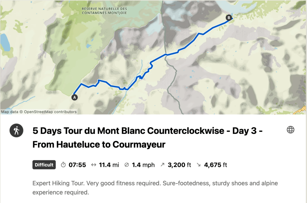
Day 3: Les Mottets > Courmayeur
Download the GPX track for the stage: https://www.visugpx.com/Twvax7D6iA
The third stage of the Tour du Mont Blanc will take you from France to Italy, crossing spectacular alpine landscapes. The stage begins at the Refuge des Mottets, and after only 4 kilometers and about 600 meters of positive elevation gain, you will reach the Col de la Seigne. This pass, perfect for waking up, marks your entry into Italy and offers breathtaking panoramic views of the surrounding mountains.
After the Col de la Seigne, you will continue for about 9 to 10 kilometers through the beautiful Italian valley. This part of the route takes you through varied landscapes, including the picturesque Lake Combal and several mountain refuges. Each step of this stage offers a new view of the Alps, with constantly changing panoramas and opportunities for memorable photos.
Finally, you will begin a descent of 11 kilometers with a negative elevation change of 1260 meters to arrive in Courmayeur. This Italian town is a welcome resting place after this long stage. Courmayeur is full of hotels, perfect for recharging and preparing for the next stage of your adventure. Whether you choose to relax in a spa, taste local Italian cuisine, or simply rest, Courmayeur offers a perfect end to the day for this third stage of the Tour du Mont Blanc.
Col de la Seigne Lake Combal
Hotels in Courmayeur
Campings outside Courmayeur
Day 4: Courmayeur > Refuge Elena
Download the GPX track for the stage: https://www.visugpx.com/B3MhnslfBa
The fourth stage of the Tour du Mont Blanc is a day that offers a mix of challenges and relaxation. Your day begins with a climb of about 800 meters of positive elevation gain over a distance of 4 to 5 kilometers, depending on your starting point. This initial climb is an excellent way to wake up and prepare for the day ahead.
Once this climb is completed, the rest of the day is relatively “quiet” compared to other stages. You will continue for about 12 kilometers, with 330 meters of positive elevation and 600 meters of negative elevation. This part of the route takes you through the beautiful Italian valley, offering spectacular views and a relaxing hiking experience.
Before arriving at the Refuge Elena, you will have about 2 kilometers and about 300 meters of positive elevation gain left. This last climb is a final challenge before ending the day. The Refuge Elena is a popular place to spend the night, offering spectacular views of the surrounding mountains.
It is important to note that you will need to book in advance to sleep at the Refuge Elena, as it fills up quickly and there are not many sleeping options in the vicinity. In Italy, bivouacking is prohibited below 2500 meters in altitude, so it is essential to plan ahead. This fourth stage of the Tour du Mont Blanc offers a balanced hiking experience, with physical challenges, beautiful landscapes, and moments of relaxation.
Italian Valley
Where to sleep?
Refuge Elena
Day 5: Refuge Elena > Champex
Download the GPX track for the stage: https://www.visugpx.com/v4RKRYwRg3
The fifth stage of the Tour du Mont Blanc, from the Refuge Elena to Champex-Lac, is a hiking day that offers both challenges and moments of relaxation. Although this stage is quite long and some parts may not be the most attractive of the tour, it nevertheless provides a rewarding hiking experience.
The day begins with a beautiful climb of about 500 meters of positive elevation over 2 kilometers to reach the Grand Col Ferret. This ascent marks your crossing into Switzerland, a moment to celebrate, but also to consider for your phone’s internet data, as Switzerland may not be included in your European plan depending on the operator.
From the Grand Col Ferret, a descent of about 20 kilometers and 1600 meters of negative elevation awaits you. This descent brings you closer to Champex-Lac, your destination for the night. It’s worth noting that part of this stage can be done by bus by taking the shuttle at Ferret or La Fouly, which can be an attractive option for those wishing to save some energy.
You then have 6 kilometers and 600 meters of positive elevation remaining to reach the Relais de l’Arpette, where you will spend the night. It is also possible to sleep at the Camping des Rocailles in Champex, which is located about 45 minutes before the Relais de l’Arpette.
Grand Col Ferret (Italy/Switzerland border) Option to take the shuttle at Ferret to Champex and avoid walking for 4 hours Supermarket in La Fouly to restock if needed
Relais de l’Arpette Camping des rocailles (in Champex)
Day 6 (option 1): Champex > Col de Balme (via La Forclaz) > Tré le Champs.
Download the GPX track for the stage: https://www.visugpx.com/f8P8nDc8xt
The sixth stage of the Tour du Mont Blanc, from Champex to Tré le Champ, is a quite hard hiking day even without taking the variant via the Fenêtre d’Arpette. This stage also marks your return to France.
Your day begins with a climb towards the Col de la Forclaz, followed by another ascent to the Col de la Balme. The Col de la Balme is a highlight of this stage, offering spectacular views of the surrounding mountains. The refuge here is a beautiful place to take a break and enjoy the scenery. The passage at the Col de la Balme also marks the border with France, another significant milestone of your journey.
After enjoying the Col de la Balme and a drink at the refuge, you will begin a descent of about 6 kilometers with 700 meters of negative elevation to reach Tré le Champ and the Auberge de la Boerne. This descent offers another opportunity to enjoy the alpine landscapes while approaching your destination for the night.
It’s important to note that you need to book your night at the Auberge de la Boerne in advance, as it fills up quickly. The bivouac area is not the largest, so it’s advised to set up your tents quickly. Once settled, you can enjoy a wonderful meal at the inn and take advantage of the showers if you wish.
Col de la Forclaz Col de la Balme
Auberge de la Boerne (hostel) Auberge de la Boerne (camping)
Day 6 (option 2): Champex > Col de Balme (via Fenêtre d’Arpette) > Tré le Champs
Download the GPX track for the stage: https://www.visugpx.com/iIoAINv20C
The sixth stage of the Tour du Mont Blanc, from Champex to Tré le Champ with the variant via the Fenêtre d’Arpette, is considered one of the hardest of the Tour, but also one of the most beautiful and rewarding.
Starting from Champex, you’ll begin a climb over 6 kilometers with an elevation gain of 1100 meters. This ascent is a challenge in itself, with some complicated passages to reach the Fenêtre d’Arpette, and the trail can be difficult to follow. It’s essential to be cautious on the way, check the weather and trail conditions beforehand carefully. Some passages may still be snow-covered and dangerous if the weather is not favorable.
Once you reach the Fenêtre, take the time to rest and savor your accomplishment. You then have a descent of about 4 kilometers with 1000 meters of negative elevation before arriving at the Chalet des Glaciers. Here, you can reward yourself with a cheese crust and a good beer.
After a well-deserved break, you’ll embark on another ascent to the Col de la Balme, about 2 kilometers with approximately 600 meters of elevation gain. The view and refuge here are magnificent, and it’s recommended to make the most of it.
Finally, you have “only” 6 kilometers and 800 meters of negative elevation to reach Tré le Champ. As always, make sure to book your night in advance, whether in a refuge or bivouac, as these places fill up quickly. The bivouac area is not the largest, so it’s advised to set up your tents quickly. Once settled, you can enjoy a wonderful meal at the inn and take advantage of the showers if you wish. This stage of the Tour du Mont Blanc offers an unforgettable hiking experience, with physical challenges, breathtaking views, and well-deserved moments of relaxation.
Fenêtre d’Arpette Col de la Balme
Day 7: Tré le Champs > Les Houches
Download the GPX track for the stage: https://www.visugpx.com/3kIaPa8PzP
Congratulations! You’ve reached the seventh and final stage of the Tour du Mont Blanc, from Tré le Champ to Les Houches. It’s a flexible day, adaptable to your needs and desires, whether in terms of accommodation, transport, or difficulty level.
If you choose to descend to Les Houches, prepare for a full day. However, many “exits” are available along the way, allowing you to adjust your day according to your physical condition and desires.
You have the option to take the cable car from La Flégère to Chamonix, offering a quick descent and a stunning view of the valley. Another option is to take the cable car from Brévent to Chamonix, another way to enjoy the view without the effort of descending.
If you feel up to it, you can also choose to walk down to Chamonix before the ascent of Brévent. This option allows you to fully enjoy the natural beauty of the route, while offering one last physical challenge.
During this day, you will pass through the Aiguillette d’Argentière and its ladders, as well as the Col du Brévent. Both points offer spectacular views and are highlights of this final stage.
Whichever option you choose, this last stage of the Tour du Mont Blanc is an opportunity to celebrate your achievements, enjoy the last beautiful views, and finish your adventure in style.
Aiguillette d’Argentière Col du Brévent
Les Houches Chamonix Option to take the cable car from La Flégère to Chamonix Option to take the cable car from Brévent to Chamonix Option to walk down to Chamonix before the ascent of Brévent (expect 1h30 to 2h of steep descent)
Submit a Comment
Your email address will not be published. Required fields are marked *
Please enter an answer in digits: eight − 3 =
Submit Comment
- Follow Follow

This article was written by Hugo, a hiking enthusiast and co-creator of TMB-Guide.com. This site is your gateway to your adventure on the Tour du Mont Blanc. We strive to share as much information as possible about the Tour to help hikers prepare for their trips.

Tour Du Mont Blanc Itinerary – 5 Days on the TMB with GPS Map & packing list
We use affiliate links and may receive a small commission on purchases. Read more about us.
5 Day Itinerary for Lightweight Backpacking from Chamonix to Rifugio Bonatti
Explore the French and Italian Alps Hiking Actually Hiking AROUND Mont Blanc with this Tour du Mont Blanc Itinerary.
Do you have a week of vacation and want to maximize your sense of WONDER by:
- Feeling the luscious burn of hiking around Europe’s highest peak –
- Hearing the tinkle of alpine cow bells –
- Tasting cheese from said cows munching wild herbs on the mountaintop –
- Seeing incredible and varied Alpine landscapes, wildflowers and wild animals –
- Sleeping in comfortable beds each night –
- Drinking locals wines and tasty beers on the top of a mountain –
- Experiencing French, Italian and Swiss culture all in one trek –
- and totally UNPLUGGING from the world below….
The Tour du Mont Blanc itinerary hike offers a chance to connect to what really counts and you don’t have to be a mountaineer to do it. Training ahead of time is adviseable, but I followed along a family last year that did it with 2 six year olds and a 2 year old toddler.
Read until the end where you can download and print a packing list with everything you need to do the trek, but keep your backpack light.
Protip: Staying in a mountain refuge is not exactly a hotel. Learn more with my detailed guide to the accommodations on the Tour du Mont Blanc and what the average costs of the TMB are.
A light backpack = A Happy hiker.
What You Will Learn
Final Verdict: Ways to Book a Hut to Hut Hiking Trip
5 days itinerary tmb map, tour du mont blanc in 5 days, tour du mont blanc itinerary for 1 week of vacation, getting to the tour du mont blanc, tour du mont blanc difficulty, stages tour du mont blanc itinerary 5 days, stage 1: les houches to les contamines, stage 2: les contamines to refuge du col de la croix du bonhomme, stage 3: col de la croix du bonhomme to cabana combal, stage 4: cabana combal to courmayeur, stage 5: courmayeur to rifugio bonatti, where to stay directly on the tour du mont blanc trail, printable tour du mont blanc packing list, costs of the tour du mont blanc, when to hike the tour du mont blanc, resources to plan your tour du mont blanc hiking trip, tour du mont blanc self guided itinerary – help, guided tour du mont blanc.

Self-Guided Tour Planning Service
- [Self-Guided] - You're on your own once you start
- Must book in Oct to Jan of year prior to hike
- Fully done for you route
- Service finds and books your huts
- Maps provided on app
What we liked: The logistics of the TMB and other hut to hut hikes can be very daunting, especially if you don't speak Italian and French.
Note: Lesser known trails are often easier to book.
- Ease of route
- No finding or dealing with huts
- Tapping into expertise
- No waiting for slow hikers
- No feeling rushed if you're slower
- Less control of dates
- No guide on the trail
- Unknown - you didn't "plan"

Guided Group Tour : 4 Days
- small groups (<10 typically)
- local Chamonix guides
- all transfers/breakfast/dinner/accommodations included
- airport transfer included
- stay in the insanely beautiful Rifugio Bonatti and other huts at high elevation
What we liked: Designed for busy people that want to experience the highlights of the Tour du Mont Blanc without having to take 2 weeks of their precious vacation time. Everything is done-for-you and you can show up and relax in the most stunning mountains.
Note: The standard price includes shared rooms in the huts.
- All transfers included
- Best price for a guided trip
- Local Chamonix Guides
- At the mercy of group pace
- Not the full circuit

DIY: Book Your Own Huts
- Cheapest Option
- Most Freedom
- Take side excursions as you like
What we liked: The challenge of it. It's so fun to route plan, find trails and the huts you want. Often it's not the expense saved, but the learning of the trail while planning that is satisfying.
Note: Be prepared to spend some time with spreadsheets and wait weeks for replies from hut owners. BONUS: Click on the link to watch my 10 part video series on HOW to book a hut to hut trip. It's a Dolomites hut trip but it's basically the same process for TMB.
- Cheapest option
- Most freedom
- Learn the Trail by planning
- You must be organized
- Map skills are essential

- campgrounds can be crowded
- reservations often needed in advance
- Wild camping is prohibited or limited by elevation
Not really my favorite thing for hut to hut trails in Europe. The huts are quite often the best part of the hiking trip and the rules are so complicated about wild camping.
- Price is good
- More Flexibilty
- Wild camping is tricky
- Rules change
- harder and heavier pack

Magical 5 Day Backpacking Trip Around the highest Peak in Europe
Example tour du mont blanc itinerary.
Follow along my journey of planning my first time hiking the Tour du Mont Blanc. The past 3 years I’ve planned summer hiking treks in the Dolomites and this year I wanted to tackle the famous Tour du Mont Blanc that spans 3 countries. You actually start in France, walk to Italy and then Switzerland and back to France. Very Cool!
I got started in December to book mountain refuges and found limited offerings on this top-rated trekking trail in Europe . Next time, I would begin the work early in September to book refuges.
We were limited to less than a week for travel so I picked the best 5 days on the trail that made sense for our group of travelers.
Tour du Mont Blanc Backpacking Trek

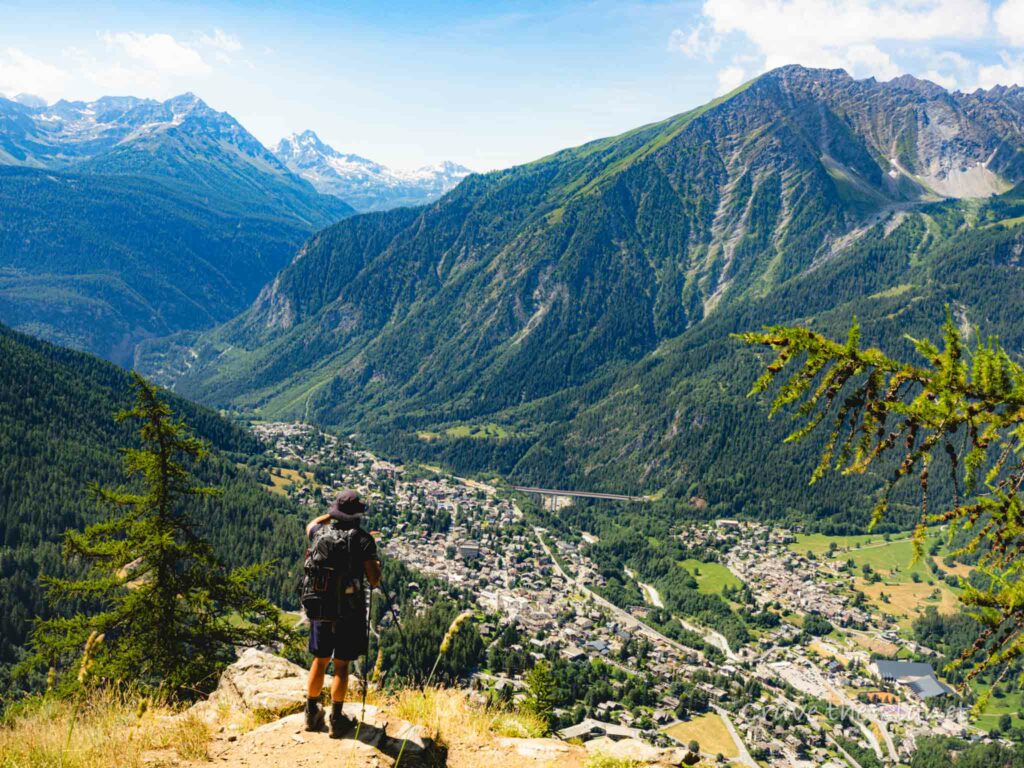
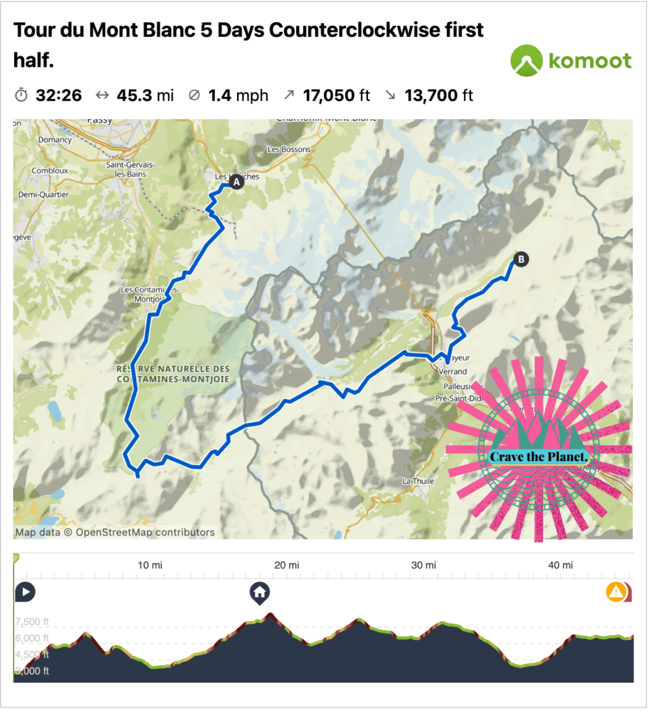
5 Day Section – 1st Half Location: Mont Blanc, France & Italy Distance: 45.3 mile Loop with Bus Time: Approximately 5-7 hours daily Elevation: 🔼17,050 ft 🔽13,700 ft Difficulty: Moderate due to rocky terrain and elevation gain Where to Stay on Final night: Armancette Hôtel, Chalets & Spa in Chamonix
It would be so nice to do the entire circle around Mont Blanc, Europe’s highest peak. However, my friends and I work at jobs that prohibit taking off weeks at a time to go trekking. So the next best thing is to do the first half of the trail and plan it so that we spend the least amount of time on buses.
Fortunately, there’s a tunnel under Mont Blanc with bus service so it makes it easy to begin hiking at the traditional start in Les Houches and walk 5 days to Rifugio Bonatti and take a bus back to the start.
Geneva is the closest airport where you can rent a car or take a regularly scheduled bus to Chamonix. Once inside Chamonix you can walk everywhere within the town.
2 Days in Chamonix
Chamonix is a nice place to relax before the hike because there are many hotels, restaurants and things to do and it’s a 15 min drive to the trailhead in Les Houches.
The day before the hike we will take two cars the end of our hike near Rifugio Bonnati and park the big car in a free public parking lot. Both drivers will then return to Chamonix and we’ll leave a car there.
Without cars you can utilize bus ARRIVA I59055 towards Funivia Sky Way (30) to return to Chamonix from Courmayeur. In effect you’ll walk one way and take the bus back to the start. There are many buses that connect Geneva to Chamonix and Chamonix to the trailhead in Les Houches. Check the bus timetables here .
This hike is not especially technical but it’s certainly challenging due to the amount of elevation change. Prepare your knees and bring your trekking poles because 🔼17,050 ft 🔽13,700 ft is a lot over 5 days. I’m going to guess that the decent to Courmayeur at the end of the day will sting a bit.
From Luxury Alpine Town in France to Luxury Alpine Town in Italy by Foot
Arrival Day: Get to Chamonix, France. Stay there the night before big hike and get a lot of sleep. There are many bus and private taxi or van connections from airports such as Geneva, Switzerland.
Tour du Mont Blanc Route
Get a hiking app for your Mont Blanc itinerary that is GPS enabled and download your track to your phone before the hike. This will ensure your phone can help you stay on the correct trail even without service. I like Komoot because you can plan day by day and have planned this TMB hiking trip here. But you can use whichever one is best for your TMB itinerary.
Tour du Mont Blanc Hike Map
If you are new to the world of hiking apps please read my article on how to use komoot app for hiking. It’s a total game changer and not really that hard to learn. I’m a huge fan of the multi-day option for paid subscribers. It gave me options on all the accommodations nearby the trail to make it really easy to plan distances.
Tour du Mont Blanc Trail
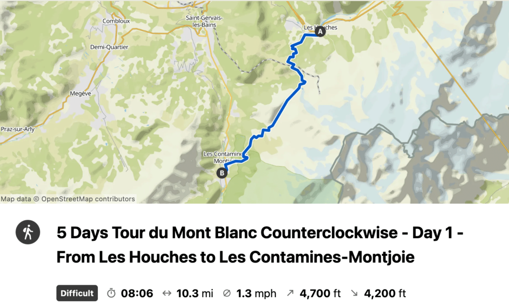
Monday July 10 – Day 1:
Hike 16.4 km
Enjoy a relatively easy warm up to the trail and we can use the gondola to shave off some elevation gain if we want. Stop at Auberge Truc for lunch.
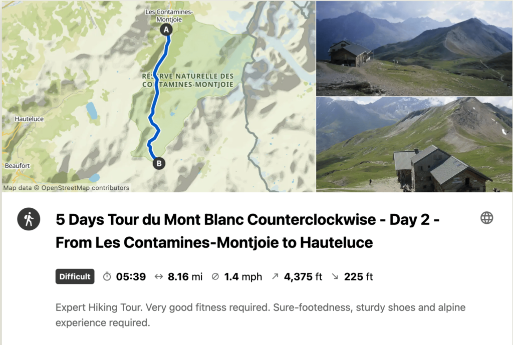
Tuesday July 11 – Day 2:
Hike 13.13 km
We will be going pretty much in one direction today, up.
Wednesday July 12 – Day 3:
Hike 18.3 km
What a day! Views of glaciers and Mont Blanc almost all day.
Thursday July 13 – Day 4:
Hike 14.4 km
We’ll descend into the Italian mountain town of Courmayeur and stay in a real hotel tonight and hopefully spend some time on the cobblestone town center eating delicious Italian food.
Friday July 14 – Day 5:
Hike 11.6 km
We’ll climb uphill all day with incredible views to the Bonatti rifugio. It’s a short day so we may opt to do some dayhikes from Bonatti or side excursions.
I’m planning for us to park the second car at Parcheggio Lavachey near Bonatti prior to the hike. It is a 3.3 km walk from the rifugio to the parking lot. There’s a restaurant nearby so I’m assuming it’s passable in summer.
It’s a 45 min drive thru tunnel back to Les Houches where the other car will be parked.
Accommodations on the Tour du Mont Blanc Trail
What is a refuge? Generally speaking they are high elevation accommodations of varying amenities. They are called refuges, rifugios, huts, or hütten, depending upon which language is spoken.
They range from luxurious to very spartan. Some have water, some run out. It all depends. But what is universal is that they are a pain in the butt to book. However, they are perched in some of the most beautiful and isolated landscapes in the world. As an American, i can hardly believe that such a thing exists. And they usually serve delicious 3 course dinners and have a breakfast with yummy coffee and lots of bread.
TMB Mont Blanc
Day 0 – arrival day in chamonix.
You’ll want to find your own accommodations in Chamonix prior to the hike. I would recommend to book your hotel on this website as it’s reliable to find a comfortable stay within the town of Chamonix or nearby. It’s a compact Alpine town and you can easily walk to dinner along the stream. It’s very ritzy and fun.
Day 1 – Les Contamines Airbnb
As of December 5, I couldn’t find any huts, campgrounds or booking.com places available for our date in early July before the high season. Whew. But I did find a chalet to fit the 6 of us with 3 bedrooms somewhere near the town of Les Contamines. It’ll be an easier day of hiking but that’s good for warming up.
Day 2 – La Croix Bonhomme Refuge
Hopefully it’s not raining because this is a true mountain hut on the top of a mountain with panoramic views. The facilities are super basic but that’s the point. It’s a respite from the world below.
Dormitory style prices for 2023:
26.50 bed 32.50 breakfast and dinner 8.00 sack lunch
Contact La Croix Bonhomme Refuge
No credit cards. You’ll want to bring a sleep sac which is like a liner to protect against bed bugs, lice, etc. They don’t want your body grease on their pillows and blankets basically. They should have showers especially in early July but you’ll probably have to pay for them and it’ll be quick, like 90 seconds. Bring your own quick dry towel and mini tolietries.
Other refuges in the area: Les Mottets
Day 3 – cabane du combal refuge.
A nicer hut from online reviews, we’ll see. The prices are higher and I’m assuming it’s half board, their website is pretty basic and it’s hard to tell. They use the https://reservation.montourdumontblanc.com/ site to book but do reply to emails. I did not have pay a deposit but we got room 4 and room 6. We’ll have to do a competition to decide which couple gets the whole room to themselves.
4 person room prices for 2023:
90.00 euros per person.
They have towels and soaps here.
Other refuges in the area: Rifugio Elisabetta
Day 4 – courmayeur.
Here we’re in a glitzy Italian alpine town so there are hotel and airbnb options. I used Hotel Triolet because they offer a nice breakfast and comfortable looking rooms.
Double room prices for 2023:
160.00 euros per room including breakfast.
We should plan to have a nice dinner out in town and soak up the cobblestone pedestrian areas and maybe even do some shopping.
Other accommodations in the area: Check on this Hotel Website
Day 5 – rifugio bonatti.
A hut with great views and isolated up the mountain from the valley where Courmayeur is located. It’s likely not to have great services but it’s half board and there’s not a lot of other options. We have 1 private room for 2 people plus extra bed and one private room for 3 people. Girls and guys? Who snores the least?
L’équipe del Rifugio Alpino Walter Bonatti
3 person room prices for 2023:
85.00 euros per person half board.
Other refuges in the area: Chalet Val Ferret
Packing list for the tour du mont blanc.
💡 It’s not about what you bring, it’s about what you don’t bring.

Not sure what to bring?
Go lightweight. It’s not necessary to bring a lot of stuff on a hut to hut hike. The huts (refuges) provide the food, beds, toliets, etc. Most people wash out their hiking clothes and hang to dry each night.
The refuges or mountains huts allow you to bring very little in your backpack. The lighter your pack is the more happy of hiker you’ll be. There are some services to do luggage transport to the refuges, however this goes against the idea of responsible travel. There’s really no need to make someone drive your luggage up to a mountain hut, or worse, load up a mule with your crap.
You’ll be hanging out with other hikers each night in the refuges to have dinner. Realistically, you’ll need one set of lightweight clothes that don’t stink to enjoy the dinner and breakfast services.
It’s totally kosher to wash out your hiking clothing and hang them up on the railings or provided laundry lines (at some refuges).

Click here to download free PDF Tour du Mont Blanc Packing List
Accommodations on Trail
You can go pretty lux in the towns of courmayeur and chamonix if you choose..
Please see the detailed Airtable towards the end of the article where I’ve documented the costs for the year 2023. But in summary inflation is hitting everywhere:
–in towns, you’ve got more options for hotels & airbnbs that run 135 euros for a double and up
–The mountain refuges with half board range between 67 to 90 euros per person per night
–Of course, the earlier you book you may find better deals.
–Sack lunches are quoted at 11 euros
–Meals in town at restaurants have increased recently to 15 euros and up per meal
Mid-June to Mid-October is when the huts and trail are open.
The alps in august can be crowded.
–August is Italian/French/German vacation time, so you’ll be in high season.
–July has the best weather for families that need to do this trek during school break.
–Early June is chilly you can run into some snow. Same for late September and early October.
If you aren’t going with kids, early September would likely be the best as it’s least crowded and still warm.
However, there are absolutely no guarantees on weather. You’ll probably hit thunderstorms in the late afternoons so most people tend to get to their rifugios before 3 pm.
Read my full guide on when to hike the tour du mont blanc .
1. I started with the Montourdumontblanc website to assess the high mountain refuges. However, not all of the options are on this site, but it’s a great starting point and has a nice interactive map. These places are only open mid June to Mid October.
https://www.montourdumontblanc.com/uk/index.aspx
2. Google maps. Duh.
3. A great itinerary to do the entire Tour du Mont Blanc in 7 days . The author gives nice descriptions of the landscapes and it may suit more advanced hikers who want to move faster and cover more ground each day.
4. You can use travel sites like Airbnb and Booking to find hotels in Chamonix , Les Houches, Courmayeur and Les Contamines as they have offerings in the valleys.
5. The T our du Mont Blanc Facebook group is a wealth of inspiration and information.
6. Private car transfer Chamonix to Geneva Airport .
7. Customized Airtable TMB Planne r. I built this Airtable to keep myself organized and track the expenses. Copy and paste it to make it your own.
8. Detailed guide on how to use trekking poles and best budget trekking poles buying guide . You will definitely want them on this trek.
9. Plan your hiking time with a calculator.
10. Read my guide on how hard the Tour du Mont Blanc hike is.
If it all seems to much to plan, you can hire a service to take care of the logistics but not have to utilize an in person guide.
Businesses such as Alpenventures Unguided will do the heavy logistical lift for you. You can simply just show up and hike. They will book your huts and provide maps and directions to do the hike on your own terms.
If I had a little more cashflow I’d use this to save about 20 hours of emailing back and forth and managing spreadsheets.
There are also guided tours if you want a local mountaineer to walk with you for extra safety, context and fun. Cloud 9 Adventures and Mont Blanc Treks offer the Classic Tour du Mont Blanc, mini TMB treks and other variations that are led by a professional guide to ease your stress.
Other Great High Alpine Multi Day Hut to Hut Hikes in Europe
Italian Dolomites vs Tour du Mont Blanc? Are you curious about the other bucketlist hut to hut hiking trip in Europe’s high mountains? Our family has done the Alta Via 1 in summer 3 times so we’ve got a lot to say. Mostly about the food.
💞 Podcasts? Listen to our 3 different long form stories about hiking the Alta Via 1 on multiple trips that we’ve done with family and friends over the years. 🥾 Trails Worth Hiking Spotify , Apple , Website . He takes a deep dive into long distance trails and the history and mythology behind them. 🎧 Amateur Traveler focuses on the practical travel and highlights history : Website , Spotify , Apple . 🍻 Streets and Eats is all about the food and experience : Website , Spotify , Apple .
Author profile : Morgan Fielder is a Doctor of Physical Therapy and passionate hiker who believes in exploring the world on foot with good food. Follow her journey as she shares science-based hiking tips and advocates for sustainable tourism.

Tour du Mont Blanc
Bonneville, France
“Embark on the Tour du Mont Blanc, a majestic alpine adventure through three countries' stunning landscapes and rich cultural tapestries.”
The Tour du Mont Blanc is a spectacular multi-day trek that encircles the Mont Blanc massif, traversing through parts of France, Italy, and Switzerland. This renowned trail covers approximately 165 kilometers (around 102 miles) and involves an elevation gain of roughly 8000 meters (about 26,247 feet), offering a medium difficulty rating that appeals to many hikers with a good level of fitness.
Starting Point and How to Get There
The traditional starting point for the Tour du Mont Blanc is in the Chamonix Valley, near the town of Les Houches, close to Bonneville, France. To reach the trailhead, hikers can fly into Geneva International Airport and take a bus or shuttle service directly to Chamonix. For those driving, Chamonix is accessible via the A40 motorway, and there are parking facilities available for the duration of the hike.
Navigating the Trail
Hikers can rely on the HiiKER app for detailed maps and navigation assistance throughout the trek. The trail is well-marked with signs and the iconic red and white stripes, making it easy to follow. However, due to the trail's length and varying weather conditions, it's essential to have a reliable navigation tool.
Landmarks and Scenery
As you embark on the Tour du Mont Blanc, you'll be treated to an ever-changing backdrop of some of the Alps' most stunning scenery. The trek includes breathtaking views of glaciers, rugged peaks, and picturesque valleys. Notable landmarks include the Col de Voza, where you can witness panoramic views of the Chamonix Valley and the Bionnassay Glacier.
Crossing into Italy, the trail takes you through the Val Ferret, where the Grandes Jorasses looms overhead. In Switzerland, the charming town of Champex-Lac provides a serene setting beside a crystal-clear alpine lake.
Wildlife and Nature
The diverse ecosystems of the Mont Blanc massif are home to an array of wildlife, including marmots, chamois, and ibex. Birdwatchers may spot golden eagles and bearded vultures soaring above. The trail also winds through vibrant meadows filled with alpine flowers, especially in the spring and early summer.
Cultural and Historical Significance
The region is steeped in mountaineering history, with Mont Blanc being one of the most coveted summits for climbers. The trail itself passes through ancient villages and towns where hikers can experience the rich cultural heritage of the Savoie region in France, the Aosta Valley in Italy, and the Valais in Switzerland.
Accommodation and Resupply Points
There are numerous refuges, gîtes, and inns along the route where hikers can rest and resupply. It's advisable to book accommodations in advance, especially during the peak hiking season.
Weather and Best Time to Hike
The best time to hike the Tour du Mont Blanc is from late June to early September when the mountain passes are typically free from snow. Weather in the Alps can be unpredictable, so hikers should be prepared for sudden changes and carry appropriate gear.
Safety and Preparation
Due to the trail's elevation gain and alpine environment, it's crucial to be well-prepared. Hikers should acclimatize to the altitude, carry layers for changing weather, and have a good level of hiking fitness. It's also wise to have travel insurance that covers mountain rescue and healthcare.
By following these guidelines and preparing adequately, hikers can embark on the Tour du Mont Blanc with confidence, ready to enjoy one of the world's most iconic long-distance treks.
WHAT TO SEE
Auberge Refuge de la Nova
WHERE TO STAY
aire naturelle de camping
User comments, reviews and discussions about the Tour du Mont Blanc, France.
average rating out of 5
53 rating(s)
Nearby Trails

Hendaye, France
3041.0 km · 93491 m

Thonon-les-Bains, France
624.5 km · 25907 m

Goûter Route
18.4 km · 4011 m
- Route planner
Hiking on the roof of Europe – Tour du Mont Blanc
The Tour du Mont Blanc (TMB), one of the most well-known GR footpaths in Europe, takes you 170 kilometres (105 mi) along magnificent trails between France, Italy and Switzerland. Three countries, seven days of walking, and a succession of breathtaking landscapes. The scenery changes frequently, allowing you to discover the Alp’s true variety. You plunge into the heart of glacial valleys, climb sumptuous passes, cross alpine pastures, forests and mountain villages, all while enjoying breathtaking views of Mont Blanc. This hike is impressive. In this Collection, I propose a seven-step itinerary which is quite challenging but also leaves plenty of time to enjoy all that the route has to offer. You can of course do the TMB at your own pace. There are many refuges and gîtes along the way, allowing you to tailor the hike to your needs. The TMB has few technical passages and is suitable for anyone who is in good shape. This itinerary follows the main route of the TMB in the classic direction of walking (counter-clockwise). Each stage of this hike ends at a refuge, which is part of what makes the TMB so special. You can enjoy delicious local food and products, but you’ll need to have a certain affinity to cheese to fully enjoy it. For those who prefer to pitch a tent, I suggest bivvy and camping options wherever possible. I did part of the TMB with a bivvy bag and would strongly recommend splitting the nights between camping and refuges. Bear in mind that bivvying is not permitted across the TBM. The rules concerning bivvying are as follows: - In France, bivvying is authorised in dedicated areas; - In Switzerland, it is forbidden to bivvy; - In Italy, bivvying is allowed above 2,500 metres (8,200 ft) of altitude. The route starts at the train station in Les Houches. You can get there by train or by bus. If you drive to Les Houches, you can park in the free parking dedicated to the TMB next to the Prarion gondola, and join the trail directly from there. If you arrive a day before you set off, you can easily find a place to stay in Les Houches either in a campsite or hotel. The trail also ends at a train station. In addition to the maps in this Collection, you regularly find road signs with the letters TMB along your hike, indicating that you are on the right track. I recommend doing the TMB between mid-June and mid-September when the mountain huts and gites are open. Book your nights in a refuge, especially if you plan to hike during the high season between 14th July and 15th August. From the end of June until the beginning of September, the TMB is calmer and the temperatures are milder. Avoid planning your hike during the last week of August when the series of races of the Ultra-Trail du Mont-Blanc (UTMB) take place. General information about the TMB (accommodation, map, reservations): autourdumontblanc.com Information about the bus lines to Les Houches: chamonix.montblancbus.com/fr/ligne-de-bus
Do it yourself
Ready to get going? Create and customize your own version of this adventure using the full Tour below as a template.
Le Tour du Mont Blanc
Last updated: April 18, 2024
Étape 1 : des Houches au Refuge de la Balme — Le Tour du Mont Blanc
This first day starts at Les Houches SNCF station, where you can arrive by bus or train. If you come by car to Les Houches, you can park in the parking lot dedicated to the TMB, next to the Prarion cable car, and join the path directly.
Étape 2 : du refuge de la Balme au rifugio Elisabetta Soldini Montanaro — Le Tour du Mont Blanc
A very nice stage that takes you to the top! From the Balme hut, you start by going up to the Col du Bonhomme, at 2,329 m altitude. A superb path then takes you to the Col de la Croix du Bonhomme and its refuge, at an altitude of just over 2,400 m. The panorama is splendid, you can see from the Haute … read more
by Chloé Perceval
Sign Up To Discover Places Like This
Get recommendations on the best single tracks, peaks, & plenty of other exciting outdoor places.
Étape 3 : du rifugio Elisabetta Soldini au rifugio Giorgio Bertone — Le Tour du Mont Blanc
A magnificent third stage, which I personally really loved. You start in the Italian Vény Valley, surrounded by glaciers, alpine lakes and towering peaks. A mountain path takes you to altitude. This is a passage that I personally found quite unreal. I had this great feeling of walking alongside the glaciers … read more
Étape 4 : du rifugio Giorgio Bertone au gîte alpage de la Peule — Le Tour du Mont Blanc
A superb stage through the Italian Val Ferret, which takes you to Switzerland.
Throughout this stage, you take superb mountain trails, surrounded by glaciers and peaks. The views never cease to be breathtaking. It is not uncommon for you to come across a few herds of cows as well.
The challenge of the … read more
Étape 5 : du gîte alpage de la Peule à Champex-Lac — Le Tour du Mont Blanc
On this fifth day, a little less elevation gain on the program. From the Peule alpine gîte, you descend into the Swiss Val Ferret.
Total change of scenery as soon as you arrive at La Fouly. You then cross a series of very typical small villages and hamlets. Traditional wooden chalets, flowered windows … read more
Étape 6 : de Champex-Lac à Tré-le-Champ — Le Tour du Mont Blanc
A very beautiful stage, between passes and villages, which will bring you back to the Chamonix Valley. There are many water points on this section.
From Champex-Lac, you start by going up to Col de la Forclaz via a pretty mountain path. From there, you begin your descent to Trient, a pretty little very … read more
Étape 7 : de Tré-le-Champ aux Houches — Le Tour du Mont Blanc
This is your last stop on the TMB. Today, you will rally Tré-le-Champ to Les Houches in an incredible setting.
You start your day by going up to the Aiguillette d'Argentière. You are then in the Aiguilles Rouges national nature reserve. With a little luck, you may come across ibex on this section. After … read more
Like this Collection?
Questions and comments, collection stats.
- Distance 105 mi
- Duration 68:57 h
- Elevation 31,125 ft
You Might Also Like
Tour du Mont Blanc (clockwise version)
Hiking route » France » Haute-Savoie » Haute-Savoie » Les Houches » Tour du Mont Blanc (clockwise version)
- Add to favorites
- Submit as 'Recommended'
- Invert route
- Change starting point
- Split route
JavaScript is required for this feature, but it is either disabled or not supported by your browser. Please enable JavaScript or upgrade your browser.
Source: Hirschnase
Route information
3908 views | Public | French
Description by the author
Tour du Mont Blanc or TMB is considered one of the top hikes you can do in the world. It is also one of the most popular long-distance walks in Europe. It circles the Mont Blanc massif , covering a distance of roughly 170 kilometres (110 mi) with 10 kilometres (6.2 mi) of ascent/descent and passes through parts of Switzerland , Italy and France . A classic!
This version of the walk is the clockwise version. Most of the people do the counter-clockwise version in about 11 days.
The most popular start points are:
- Les Houches in the Chamonix valley
- Les Contamines in the Montjoie valley (in France)
- Courmayeur from the Italian side
- Champex in Switzerland
- A point near Martigny in Switzerland
The route passes through seven valleys around the Mont-Blanc massif:
- the Chamonix (or Arve) valley
- Vallee des Glaciers
- Italian Val Veni
- Swiss Val Ferret
- Trient valley in Switzerland
The ‘official’ route has changed over the course of the years and many alternatives, or ‘Variantes’, exist to the standard route. Some of these take the intrepid walker onto paths requiring greater fitness, awareness and skill. Others provide less demanding options, which are often quicker than the accepted route, but provide lesser viewpoints onto the mountain ranges.
Plentiful accommodation exists along the entire route, allowing it to be broken into segments to suit any fit person. This takes a variety of forms, from separate bedrooms to large mixed-sex dormitories. Cooked meals are available at most.
The highest points on any variant of the trail are the Col des Fours in France and the Fenêtre d'Arpette in Switzerland, both at an altitude of 2,665 m (8,743 ft). This is not high enough to cause altitude sickness for most people, nevertheless the trail provides a tough physical challenge. Experience of walking in mountain country is vital and, because mountain weather can change very rapidly, participants on the Tour du Mont Blanc should be suitably equipped.
More information
Navigate to starting point
Places of interest
Routes nearby.
More routes...
Lodging nearby
More lodging...
Services nearby
More services...
Open with...
Navigate route in...
Please wait, your print is being prepared.
Your print is ready to download. Have fun on the road!
Processing your request has failed. Please try again.
Please wait, your download is being prepared.
Your download is ready. Have fun on the road!
This route on your website
Route image
I found the route to be...
- The route is perfectly adapted to the terrain and I have not encountered any problems.
- The geometry of the route is accurate and correct.
- The route type fits the route.
- The route has a meaningful title and description.
Additional feedback:
Try this feature for free with a RouteYou Plus trial subscription.
If you already have such an account, then log in now.
Try this feature for free with a RouteYou Premium trial subscription.
- Search for a route
- My favorites
- Best rated routes
- Most popular routes
- Node routes
- Signposted routes
- Nature routes
- Cultural routes
- Partner routes
- Create a route
- Upload a route
- Record a route
- Hiking nodes
- Cycling nodes
© 2006-2024 RouteYou - www.routeyou.com
Well and Good Travel

The Foolproof Tour du Mont Blanc Itinerary: 10-Days
10 days of hiking in the Alps – the ULTIMATE wellness trip if you ask me. This Tour du Mont Blanc self-guided itinerary follows the traditional TMB route, includes tips, daily trail specs, and accommodation suggestions, and addresses some of the most common questions you might be asking yourself as you begin planning your tour.
The Tour du Mont Blanc, or the TMB, is a 105-mile (170 km) trail that circumnavigates Mont Blanc, the highest peak in Europe. The TMB is often considered one of the most beautiful through-hikes in the world, introducing hikers from around the globe to the exquisite and dramatic scenery of the Alps.
👉 Don’t forget travel insurance for this trip! I always use SafetyWing !
Want to save yourself a lot of planning time? Check out Skyhook Adventures’ 10-day guided trek if you want all of your accommodations, food, and transportation taken care of!
Tour du Mont Blanc Itinerary 10 Days

This itinerary does not include, but I recommend, staying in Chamonix for a couple of days before and after your tour, first to acclimate and then to relax.
The TMB is broken up into “stages”. Traditionally, there are 11 stages but depending on how many days you want to trek you can find different versions of the stages.
During your planning, and your trekking, take all distance, time, and elevation markers or estimations with a grain of salt. Mileage on GPS and in guidebooks and blogs rarely match up, and there are a lot of variables that affect the accuracy of the time estimations. The trail markers seem to allot 30 minutes for every mile, but depending on your age, the weather, and what shape you’re in, that will be different for every person. For your own sake, just always assume you’ll have an additional mile or 30 minutes 🙂
Tour du Mont Blanc Trek Specs:
- Distance: 105 miles / 170 kilometers
- Route Type: Loop
- Starting Point: Les Houches (traditionally)
- Direction: Counter-clockwise (although it can also be hiked clockwise)
- Total Elevation Gain/Loss: 33,632ft / 10,251 m
- Maximum Altitude: 8,500 ft / 2600 m
- Days To Hike: 7-12 days
- Countries: France, Italy, Switzerland
- Difficulty: Difficult (never flat, always up or down)
Tour du Mont Blanc Itinerary Disclaimers:
- Most stages have alternative route options, or “variants”, as they are called. This itinerary follows the traditional TMB route, except for day 10. Refer to the recommended guidebooks for variant options.
- Some stages have options to use public transport and lifts/gondolas to accelerate and shorten the path. This itinerary discloses any shortcuts by calling out *SHORTCUT*.
- There are many mountain huts/refuges along the TMB to choose from. This allows for total personalization of your trek. The huts recommended in this 10-day tour du mont blanc itinerary are huts that I stayed in and will provide my honest opinion about.
Day 1: Les Houches to Les Contamines

Do not get off at the first stop in Les Houches – stay on until you see the Office de Tourismo (on your left). Here you will see the TMB starting point arch. Take a photo and walk onward for about 10 minutes until you see the “Telecabine Bellevue”. *SHORTCUT* This will cut off a 2600 ft / 800 m climb through the forest. Begin your trek at the top of this cable car.
You’ll pass through many towns and villages today, and you won’t feel very “out there”. The signage is decent, just make sure you pay attention and don’t pass any turnoffs. Use the guidebooks and GPS for support.
✔ Mileage: 9 miles / 14.5 km (if you take the cable car, 11 if you don’t)
✔ Elevation Gain: ~ 1000 ft / 300 m (if you take the cable car, 3550 ft if you don’t)
✔ Estimated hiking time: 5 hours (with cable car)
💤 Where to stay: Gai Soleil

Gai Soleil is a quaint and quiet hotel just off the main road in Les Contamines. There is a lovely yard to relax in after hiking all day. The rooms are basic but very comfortable with amazing views. Breakfast was great and there is wifi. I would recommend staying here.
Day 2: Les Contamines to Les Chapieux
💪 This is one of the most challenging days of this 10-day tour du mont blanc itinerary.

Today you will climb over two Cols (mountain passes). You will see fewer towns and be pleasantly surprised by the beauty that is everywhere. Be prepared for lots of elevation gain and possible weather. It can get very cold (and wet!) at the top of the cols.
When you begin to descend from the second col, you’ll pass Croix du Bonhomme – a refuge. Stop here for hot chocolate or coffee but DO NOT stay here (outhouses, flies, no showers, etc).
BONUS: Look out and listen for lots of Marmots as you descend from Croix du Bonhomme!
✔ Mileage: 14 miles / 22.5 km
✔ Elevation Gain: 4500 ft /3000 ft down
✔ Estimated hiking time: 7 hours
💤 Where to stay: Auberge de la Nova
You will see the Auberge immediately as you descend into Les Chapieux (there isn’t much else here!). Try to get a private room if you can – unless you are fully comfortable sleeping in dorms. The dinner was one of the best dinners of the trek! Hot showers but no wifi or service.
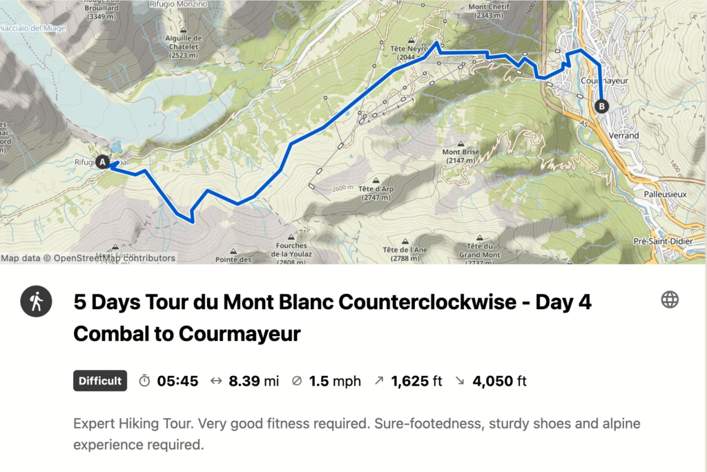
Day 3: Les Chapieux to Rifugio Cabane du Combal
🌀 One of the most beautiful days of the trek!

Today you will get your first view of Mont Blanc from the trail and cross over into Italy via Col de la Seigne. To begin, take a bus from Les Chapieux to Les Mottets (NOT Ville des Glaciers). *SHORTCUT* This will cut about an hour and a half of walking on a skinny paved road which made sense to us (and most others).
There is a small wooden information center in Les Chapieux, just outside Auberge de la Nova. You can buy bus tickets here – try and buy them the night before in order to get the first bus, otherwise, you may have to wait until the 9 am bus (or just walk).
BONUS: When you get to Cabane du Combal, continue on another 10 minutes to see Lac Miage and the adjacent moraine – you’ll see the signs outside the rifugio. If you sit and listen at the top, you’ll hear small rockslides happen every few minutes as a result of the melting glacier.
The All Trails map linked below maps you to Rifugio Elisabetta. A lot of people like to stay here but I saw the sleeping area and would highly recommend continuing on to Cabane du Combal. It’s another 30 minutes and 1.5 miles on FLAT gravel road. Definitely stop at Elisabetta for a cappuccino though. You’ll have to climb up their long and steep driveway but it is worth it!

✔ Mileage: 10 miles / 16 km
✔ Elevation Gain: 3400 ft / 1036 m
✔ Estimated hiking time: 5.5 hours
💤 Where to stay: Cabane du Combal

Cabane du Combal is a very sweet rifugio with large, clean rooms and the dinner was really very good. They tend to get herds of ibex hanging around (hence their logo), so be on the lookout! We saw several here 🙂 Lastly, there is no wifi or service here.
Also read: Tour du Mont Blanc Refuges: Everything You Need to Know
Day 4: Cabane du Combal to Rifugio Maison Vieille
🌀 One of the most beautiful days of this tour du mont blanc itinerary!

This was one of my absolute favorite days. It was a short day but SO beautiful. On several days you trek through villages and towns, but this day you are just in the mountains the entire time. You’ll be walking at eye level with glaciers and alongside grazing sheep and cows. Take your time and admire the beauty in every direction.
ALTERNATIVE ITINERARY: As much as we loved Maison Vielle, I recommend continuing past Rifugio Maison Vielle and booking a hotel in Courmayeur. Courmayeur is the largest town you will go through and a great opportunity to stay somewhere nicer, and it will balance out the distances on days 4 and 5. The Alltrails map below goes to Courmayeur.
✔ Mileage: 6 miles / 9.6 km (to Maison Vieille)
✔ Elevation Gain: 1900 ft / 600 m
✔ Estimated hiking time: 3 – 4 hours
💤 Where to stay: Rifugio Maison Vieille

As I mentioned, I would continue on to Courmayeur. However, if you choose to stay at Maison Vieille you can spend the afternoon lounging in lawn chairs and sipping on cold beers. This is a popular lunch stop for day hikers so it’s very busy and fun. They only have dorms – no private rooms, FYI. But, they do have wifi.
Day 5: Rifugio Maison Vieille to Rifugio Walter Bonatti

Maison Vieille is situated at the top of a ski lift. When you depart on day 5 you can either sleep in and wait for the ski lift to open at 9 am to take you down to Dolonne or you can walk down the very steep descent which will take you about 2 hours. * This is another reason to stay in Courmayeur because you can take the ski lift down in the afternoon the day before.
*SHORTCUT* We chose to save our knees and took the ski lift as soon as it opened. You have to take a Gondola following the lift which drops you in Dolonne. You’ll walk about 10 minutes to Courmayeur. Build in some time to walk around and get some coffee if you can because it’s very cute here.
Next, begin your ascent through a paved neighborhood and then into a popular wooded hiking area. Stop at the top at Rifugio Bertone for a snack and beverage and then continue on. Today is another day of hiking eye to eye with massive glaciers… in fact, you’ll be sleeping directly across from one at Rifugio Bonatti!
✔ Mileage: 9 miles / 14.5 km (from Maison Vieille)
✔ Elevation Gain: 3600 ft / 1100 m
✔ Estimated hiking time: 6 hours
💤 Where to stay: Rifugio Walter Bonatti

Rifugio Bonatti is situated directly across from a massive glacier – it is an unbelievable location. The rifugio is a little newer and offers dorms and private rooms that are quite comfortable and clean. The dinner was pretty good. You have to get a coin for the shower and only get 4 minutes. There is no wifi, but some service. Although, if you ask nicely the staff might share the wifi password.
Day 6: Rifugio Walter Bonatti to La Fouly

On day 6 of this Tour du Mont Blanc itinerary, you’ll cross over into Switzerland. This is an absolutely stunning day of hiking, especially the climb to Grand Col Ferret (tough!). Prepare to see lots of rolling green hills, glaciers, cows, and sheep.
✔ Elevation Gain: 3200 ft. / 975 m
💤 Where to stay: Auberge des Glaciers

This Auberge is right in the center of town – as soon as you enter La Fouly you will see it. The rooms were cute (private) and the showers were hot! Dinner was delicious but it was an expensive auberge/refuge. Conveniently, there is a market right next door if you need to stock up on snacks.
Day 7: La Fouly to Champex

Day 7 is one of the easier days of this Tour du Mont Blanc itinerary. You will be in the forest most of the time. Look for wooden animal carvings along the whole trail. This day was very rainy for us – several people ended up taking the bus from La Fouly to Champex to avoid hiking in the rain. We were soaked by the time we got to La Fouly but ultimately we were glad we didn’t take the bus. You’ll pass through some really interesting and tiny Swiss towns today – not the most exciting day though.
✔ Mileage: 9 miles / 14.5 km
✔ Elevation Gain: 2000 ft. / 609 m
✔ Estimated hiking time: 4.5 hours
💤 Where to stay: Hotel Splendide

I had originally booked Hotel Belvedere, but when we arrived I was informed I accidentally booked it for the night before. They didn’t have room for us the night we needed it but it ended up being a BLESSING IN DISGUISE. Belvedere was very dark and dingy and the husband of the husband-wife combo was RUDE. We went next door to Hotel Splendide which happened to have a cancellation. It was such a treat to stay there. The rooms are sweet and gorgeous – amazing views and breakfast!!
Day 8: Champex to Trient

This day was challenging for us, mentally. Not incredibly tough but it felt very long. This was the easiest stage to get lost, in my opinion. When you leave Champex Lac, stay on the main road through town, following the TMB signs. If you turn off the road too soon you’ll find yourself in a maze of trails and the GPS is unreliable here. You’ll see a large boulder with “bovine TMB” painted on it. This is where you turn off.
When you reach Trient, continue on another km (15 minutes) to reach Le Peuty – it’s on the map.
BONUS: If you do the main route and not a variant, you’ll pass by Alp Bovine, a small unassuming rustic restaurant in the hills. The homemade tarts are AMAZING. The views and atmosphere are warm and authentic. A must-stop.
✔ Mileage: 12.5 miles / 20 km
✔ Elevation Gain: 2800 ft. / 853 m
💤 Where to stay: Le Peuty

I booked Le Peuty on a whim because it looked unique and fun and wow am I so glad I did. This was one of, if not the top place of all the places we stayed in this tour du mont blanc itinerary. The atmosphere and vibes here are unbeatable. There is a dorm above the kitchen, a huge field for camping, and one private yurt. I booked early enough that I was able to get the yurt and it was awesome. The BEST part of our stay though was hands down the food. Dinner was cooked fresh from scratch and could have come from a multi-star restaurant. Breakfast was equally as delicious. Best food and best vibes of the trip.
Day 9: Trient to Tre le Champ

This was one of our favorite days of the TMB. Our bodies felt conditioned to the daily grind and the weather and views were gorgeous. You’ll return to France today, via Col du Balme. It’s a steep ascent to the top so stop at the top for a coffee or beer (and photos!). As you reach the top you regain an unobstructed view of Mont Blanc and it remains in site the rest of the trek.
✔ Mileage: 10.5 miles / 17 km
✔ Elevation Gain: 3400 ft. / 1036 m
💤 Where to stay: Auberge la Boerne

The location of this Auberge is great, it’s very cute and rustic, unique, and has a very cool history. However, the dorm we stayed in was literally the size of a closet (not joking see pictures). It was fine – just funny. The dinner was also not very good – maybe the worst of the whole trip. All part of the experience though! I’d probably choose to stay here again versus hiking down into Argentiere if that’s any consolation.
Day 10: Tre le Champ to Chamonix

The final stretch! Today you will go through the “ladder section” which you will hear about during your TMB planning. It is a little nerve-wracking, but totally doable so don’t be deterred. If you have an intense fear of heights, you can avoid the ladders by doing the Col Des Montets variant.
We decided to take our first variant today and go to Lac Blanc. It adds on another hour or so and a bit of elevation gain but the views are worth it in my opinion. And the hike out of Lac Blanc is very cool and different from much of the rest of the path.
When you reach the ski lift, take it down to La Flegere, then continue on the TMB path to the Plan Praz gondola. This will drop you in Chamonix! Below is the trail map to La Flegere. If you want to do the Lac Blanc variant, just follow the signs once you get to the top of the ladder section.
There are a number of options to descend into the Chamonix valley (i.e. at La Flegere, Plan Praz, or further along) so decide what is best for you. We felt strong when we reached La Felgere so we decided to continue to Plan Praz. You do NOT need to buy lift cable car tickets ahead of time. However, make sure you get there before they close (5 pm).

✔ Mileage: 11.5 miles / 18.5 km
✔ Elevation Gain: 3200 ft. / 990 m
💤 Where to stay: Grand Hotel des Alpes

Treat yourself! Stay at the Grand Hotel des Alpes , in the center of Chamonix. They have an amazing spa with a gorgeous sauna and hot tub area (this was the major selling point for me). The rooms are stunning and the beds are amazing just stay here!!
Tour du Mont Blanc Itinerary Planning Resources
Blog posts, facebook groups, the official TMB website, GPS and weather apps, and guidebooks are all of the resources you will need to plan and hike your tour du mont blanc itinerary.
This Facebook group is very active and super helpful. People share their experiences, share all sorts of tips, and provide a decently accurate picture of what the current conditions and situation is on the trail.
I carried Jim Manthorpe’s Tour du Mont Blanc guidebook (2nd edition) with me and while it is not always 100% accurate, the detailed maps and elevation and distance charts were really helpful. He also covers all of the different variants available to you.

The official TMB website is a somewhat helpful planning resource. It is also the only way to book some of the refuges so if you plan on staying in mountain huts you will need to utilize this site.
Meteoblue is a helpful weather app to have – again, not always accurate of course but it’s more detailed than weather.com.
Tour du Mont Blanc Alltrails
While not always accurate, alltrails was the best GPS app for us. There are a number of route options that are downloadable. This way, if you don’t have service (which you won’t) you can still use the map. Alltrails has all of the traditional stages mapped out, as well as variants, alternative stages, and the entire loop even.
You will need to create an AllTrails account. Search for your desired stage, crosscheck it with guidebooks to make sure it’s accurate, and then download it. While you are hiking you will be able to go into the app and click on the respective stage and the app’s GPS will follow along the route.
FAQs About the Tour du Mont Blanc Hike
If you are just getting started with your TMB planning, I’m sure you have a LOT of questions. Don’t worry, everything will start to make sense and come together. It seems more daunting than it actually is. Hopefully, this FAQ gets you off to a good start!
What is the best time to hike the Tour du Mont Blanc?
August. I hiked this tour du mont blanc itinerary August 13th-22th and it rained two of those days. Earlier August you may see less rain, but I think generally anytime in August is a great time to hike the TMB. It was in the 80s in Chamonix, but higher up on the trail it was perfect hiking weather (60s and 70s).
If you go in June, you may encounter remnants of winter, in July it may be scorching hot, and in September it could snow. That being said, the trail will be busy June through September.

How much water should I carry on the TMB?
At least two liters. Although, you may need three liters during the hottest months or if you are planning on hiking longer distances than most people each day.
I carried two 1 liter Nalgene’s (I am not a fan of camelbacks) and never ran out of water. There are several water troughs along the route to refill if you are running low, although I recommend that you never begin the day with less than two liters just in case.
There are some occasions, particularly towards the end of summer, when the water is not flowing in all of the troughs along the trail. That being said, we found at least one water refill trough at every stage – and usually several.
How far in advance should I plan my Tour du Mont Blanc Itinerary?
Approximately, 6 to 10 months. If you plan on staying in refuges/mountain huts along the trail, you’ll need to book them well in advance. I booked all of our accommodations about 7 months ahead of our trip. If you plan on camping you have some more freedom to start your planning later.

Do I have to start the TMB in Les Houches, Chamonix?
No, absolutely not! Les Houches is the “official” starting point, and made the most sense for us because we wanted to spend time in Chamonix before and after our trek. However, there are several other starting points – pretty much any main town along the path can be a starting point. The only other starting point I would consider, personally, is Courmayeur.
How do I book the refuges?
The refuges, also called mountain huts, rifugios, and auberges, depending on what country you’re in, can be somewhat challenging to reserve. They need to be booked early if you want a guaranteed spot, and they all have different booking processes. For more information on how to book the refuges, refer to my post Refuges: Everything You Need to Know .
What gear do I need for the TMB?
See Tour du Mont Blanc Packing List [COMING SOON].
What To Expect on The Trail
- A variety of weather! Make sure you pack for every condition.
- Wildlife! Specifically, marmots, ibex, chamois, vultures, deer, sheep, cows, and goats.
- Crowds. The TMB is one of the most famous treks in the world, you are going to be hiking with a lot of people. There are days when you may not see many people, but most days you will see a lot. One positive is that it makes the trek feel very safe and is a great option for solo female hikers.
- Wild berries! You will find wild blueberries along much of the route, and occasionally some wild raspberries.
- Water refill stations. As I mentioned earlier, there are several water refill troughs along each leg of the hike. Make sure to always pack enough water for the day in case they are dry. Check Facebook groups to know the status of the water before you go.

Wrap-Up: Tour du Mont Blanc Itinerary 10 Days
So, if you are on the fence about hiking the TMB, let me just give you a little push. Allow yourself to breathe in the freshest of air, to gravel at the massive glaciers all around you, to sleep in places so remote that the stars seem brighter and more abundant than any place you’ve ever been. Give yourself a screen break, clear your head, and meet amazing people from around the world. Eat fresh homemade food every day, and drink untouched mountain spring water.
Use this Tour du Mont Blanc itinerary as a starting point – take what works for you and customize the rest to your needs.

Jade Gershen is the founder of Well and Good Travel. She has lived on three continents and explored more than 20 countries in the past 10 years. U.S. based, she also shares her favorite places to go and things to do in the States. Having experienced the impacts of chronic stress Jade has a particular interest in using travel and outdoor adventure to improve well-being and shares that with her readers.
- Where to stay – Chamonix
- Geneva Airport to Chamonix
- Itineraries
- Tour du Mont Blanc Refuges
- Refuges ebook
Maps & books

Offline Tour du Mont Blanc GPS – why every TMB hiker should download the GAIA app
The TMB is a high altitude trekking circuit and every hiker planning to walk this incredible trail needs…

Which Tour du Mont Blanc guide book is best?
*Disclaimer: this post contains affiliate links – as an Amazon associate I earn from qualifying purchases. For more…
Tour du Mont Blanc Hike
Privacy overview.
Sending email...
Email sent!
You are using an out of date browser and this website will not function properly.
Please upgrade to Edge or Chrome browsers.

+33 (0)781586903
montblanctreks
- Dates & Prices
TREKKING IN 2021... See our latest blog
Tour du Mont Blanc Map

If you look at a map of the area, the Mont Blanc range forms a compact mass of complex mountain structures, passable via a circular route making use of its surrounding valleys and relatively low level cols or mountain passes.
Traditionally, the Tour du Mont Blanc starts and finishes in the Chamonix Valley and moves anti-clockwise through France, Italy and Switzerland and returns in to the Chamonix valley for the last few days of the trek.
Over time, all manner of variants have been included. For example, Col de Tricot from Les Houches to Contamines or Fenetre d'Arpette from Champex-Lac to Trient. Often these variants make the Tour du Mont Blanc more challenging with more height gain and descent and tougher terrain.
The Tour du Mont Blanc full circuit is often undertaken in reverse and can seem very different when done in the opposite direction.
Scroll down to view the full circuit, easterly and westerly routes.
Tour du Mont Blanc Full Circuit Map
Approximately 170 kilometres in length with an accumulation of 9,500m of height gain. The Tour du Mont Blanc full circuit starts and finishes in the Chamonix valley the route circumnavigates the Mont Blanc Massif taking in some of the most spectacular alpine scenery through France, Italy and Switzerland.
Click the route sections on the map for more info
Chamonix to Les Houches
Distance: 13k | Height gain: +700m | Descent: -1500m

We commence the Tour Mont Blanc full trek from Chamonix taking the cable car to the Planpraz at 2000m, from here we take the TMB route to the Col du Brevent, Brevent 2525m and descend along the stunning ridge to Refuge Bel Lachat. From the refuge, we make the long and tough descent via Parc Merlet to Les Houches and our hotel accommodation for the night.
Accommodation
3* Hotel, private en-suite rooms, evening meal & breakfast
Guide notes:
This day often feels one of the toughest on the trek generally because people are not fully acclimatised. The descent can be punishing & is probably the most difficult during the trek due 1500m sustained down hill & at times rocky terrain. Walking poles are recommended to save the knees!
Les Houches to Les Contamines
Via Bionnassay: Distance: 15k | Height gain: +100m | Descent: -700m Via Col du Tricot: Distance: 13k | Height gain: +800m | Descent: -1300m

Our day starts with a cable car ride to the Bellevue 1802m with stunning views of the Mont Blanc range from high above the westerly end of the Chamonix valley. We then have a choice of routes to Les Contamines via Bionnassay and Chapel or the Col du Tricot and Chalets des Miage.
3* Hotel, private en-suite rooms, evening meal and breakfast
Day two and you are probably feeling a little tiered from the first day. The terrain is very different today, less rugged and more green as you will be trekking though high altitude pastureland. If you are trekking via the Col du Tricot check out the Blueberry pie at the Chalets des Miage, very memorable and delicious!
Les Contamines to Refuge Mottets
Distance: 20k | Height gain: +1500m | Descent: -900m

A great day ahead awaits and we make our ascent through three cols, Col du Bonhomme, Col de la Croix du Bonhomme and the Col des Fours 2665m. Descending steeply through the wild and remote landscape to Ville des Glaciers and our rest stop for the night at the atmospheric Refuge Mottets.
Dormitory (upgrade possible), evening meal & breakfast
On paper this looks like one of the longest and toughest days on the trek but don’t worry its very doable. There is a fair amount of height gain but it is integrated with sections of gentle terrain, which make the day more manageable. The key is to start early & allow plenty of time.
Refuge Mottets to Courmayeur
Distance: 14k | Height gain: +700m | Descent: -700m

By staying at the Refuge Mottets it gives us a great position below the Col du Seigne 2516m, although we climb steeply at times we soon find ourselves over the col and across French/Italian border into Italy. We then make a descent into the stunning Val Veny with easy walking through the hanging valleys to Lac Combal. From here we descend La Visaille and take the shuttle bus to Courmayeur.
3* Hotel, private en-suite rooms, B & B
One of my favourite days on the Tour du Mont Blanc, the views from the Col du Seigne is second to none! Once you are at the col and if the weather is right rest for a while and take in the far-reaching views in to Italy & Switzerland, just wonderful!
Courmayeur to Refuge Bonatti
Distance: 17k | Height gain: +750m | Descent: -50m

Fully refreshed we make our ascent to the Refuge Bertoni and enjoy amazing views of Mont Blanc and Courmayeur down below. We spend the rest of the day on a lofty traverse from high above the Val Ferret with stunning views of the Italian side of the Mont Blanc before reaching our accommodation at the beautiful Refuge Bonatti 2056m.
A steep but steady climb up to the Refuge Bertoni, it’s worth it because the coffee is fabulous & the views just stunning, elevenses’ here is a must! Fabulous views of some of the most famous peaks in the European Alps including Mont Blanc and the Grand Jorasses. And for the refuge Bonatti... its just fabulous, if the night is clear go our side after dinner and just 'be' in this impressive location.
Refuge Bonatti to La Fouly
Distance: 20k | Height gain: +900m | Descent: -1400m

An early start and a new country awaits, we continue through the Val Ferret to Arnuva before making our long ascent to the Grand Col Ferret 2537m via the Refugio Elena and the Italian/Swiss border. We then make a relatively easy and enjoyable descent via la Peule, Ferret to La Fouly and our hotel accommodation for the night.
3* Hotel private en-suite rooms, evening meal & breakfast
Again this day looks tough but the hard bits are nicely spaced with less challenging terrain & once at the Col stare in wonder at the view looking back at your last 3 days of trekking towards the Col du Seigne & over the boarder into Switzerland. The descent is long but at an easy angle & the path is good. Plenty of opportunity to stop for refreshments at Arnurva, Refuge Elena & La Peule.
La Fouly to Champex Lac
Distance: 18k | Height gain: +750m | Descent: -950m

An easy day in comparison walking in the beautiful Swiss Val Ferret. We then pass through the Swiss villages of Praz de Fort and Issert before make our ascent to the charming village of Champex-Lac and our resting place for the evening.
Auberge with private rooms & shared facilities, evening meal & breakfast
The Bovine route is a fabulous day not too tricky over lovely terrain. Lunch stop at the high alpine farm at Bovine is a must, you can purchase local food or even eat your own picnic on the terrace as long as you buy a drink. Amazing views across to Lac Leman & down the Rhone valley.
Champex Lac to Trient

An initial easy start to the day is to be had as we wind our way on easy paths to Plan de l'Au. We then climb up steadily to the Alpage Bovine 1987m and enjoy fabulous views over Martigny and the Swiss Valais. We spend the rest of the day making our descent to the Col du Forclaz 1526m with a final descent to Trient.
Auberge with private rooms and shared facilities, evening meal and breakfast
The Bovine route is a fabulous day not too tricky over lovely terrain. Lunch stop at the high alpine farm at Bovine is a must, you can purchase local food or even eat your own picnic on the terrace as long as you buy a drink. Amazing views across to Lac Leman and down the Rhone valley.
Trient to Argentière
Direct via the Col du Balme: Distance: 13k | Height gain: +900m | Descent: -900m Via Catogne & the Col du Balme: Distance: 15k | Height gain: +1000m | Descent: -1000m

Today we have two options as we can take the route directly to the Col du Balme from Trient or through alpine woodland to the Alpage of Tseppes, Catogne and on to the Col du Balme 2191m and the Swiss/French border. From the Col, we then make our descent to the hamlet of Le Tour and across pastureland to the village of Argentiere and our hotel accommodation for the evening.
4* Hotel private en-suite rooms, B & B
Personally unless the weather is bad take the route via Catogne, the views are far superior as one up high you take a lofty traverse with excellent views over towards Emossom dam & the Aiguille Rouges nature reserve.
Argentière to Chamonix
Distance: 14k | Height gain: +1200m | Descent: -500m

Our final day and a fitting end to the trek takes us back into the Aiguille Rouges to the stunning Lac des Cheserys and Lac Blanc 2352m. We then make a descent to Flegere and take the balcony path traversing high above the Chamonix valley to Planpraz at our starting point 11 days earlier completing the circuit. A final decent via the cable car back to Chamonix in time for a celebratory drink as you have just completed the Tour du Mont Blanc, one of the best multi day treks in the world. In the event of lift closures, we make our descent back to Chamonix via Flegere.
3* Hotel private en-suite rooms, B & B
A fitting end to the trek back in the Aiguille nature reserve with pristine views of the Mont Blanc massif and all its peaks and glaciers. Visiting the iconic Lac Blanc is a must and stop for refreshments in the refuge. It gets busy with day walkers in August so make an early start if possible.

- 1. Chamonix to Les Houches
- 2. Les Houches to Les Contamines
- 3. Les Contamines to Refuge Mottets
- 4. Refuge Mottets to Courmayeur
- 5. Courmayeur to Refuge Bonatti
- 6. Refuge Bonatti to La Fouly
- 7. La Fouly to Champex Lac
- 8. Champex Lac to Trient
- 9. Trient to Argentière
- 10. Argentière to Chamonix
Tour du Mont Blanc Easterly Circuit Map
The Tour Mont Blanc easterly trek starts in Courmayeur and takes in half of the classic route anti-clockwise to Chamonix. It is a 6 day trek that covers approximately 100 kilometers through the Italian, Swiss and French alps. This walking holiday in the alps is ideal for those wanting to experience the Tour du Mont Blanc in a shorter period of time.
We make our ascent to the Refuge Bertoni and enjoy amazing views of Mont Blanc and Courmayeur down below. We spend the rest of the day on a lofty traverse from high above the Val Ferret with stunning views of the Italian side of the Mont Blanc before reaching our accommodation at the beautiful Refuge Bonatti 2056m.
- 1. Courmayeur to Refuge Bonatti
- 2. Refuge Bonatti to La Fouly
- 3. La Fouly to Champex Lac
- 4. Champex Lac to Trient
- 5. Trient to Argentière
- 6. Argentière to Chamonix
Tour du Mont Blanc Westerly Circuit Map
The Tour du Mont Blanc westerly route starts in Chamonix and takes in half of the classic Tour du Mont Blanc route anti-clockwise to Courmayeur. The route covers approximately 70 kilometers through the French and Italian alps. This trekking holiday in the alps is ideal for those wanting to experience the Tour du Mont Blanc in a shorter period of time.
We commence the Tour Mont Blanc westerly trek from Chamonix taking the cable car to the Planpraz at 2000m, from here we take the TMB route to the Col du Brevent, Brevent 2525m and descend along the stunning ridge to Refuge Bel Lachat. From the refuge, we make the long and tough descent via Parc Merlet to Les Houches and our hotel accommodation for the night.
This day often feels one of the toughest on the trek generally because people are not fully acclimatised. The descent can be punishing and is probably the most difficult during the trek due 1500m sustained down hill & at times rocky terrain. Walking poles are recommended to save the knees!
Tour du Mont Blanc Profile

Sign up to Our Newsletter
Marketing permissions.
Mont Blanc Treks will use the information you provide on this form to be in touch with you and to provide updates and marketing. Please let us know if you are happy to receive emails from us by checking the box below.
You can change your mind at any time by clicking the unsubscribe link in the footer of any email you receive from us, or by contacting us at [email protected]. We will treat your information with respect. For more information about our privacy practices please visit our website. By clicking below, you agree that we may process your information in accordance with these terms.
We use Mailchimp as our marketing platform. By clicking below to subscribe, you acknowledge that your information will be transferred to Mailchimp for processing. Learn more about Mailchimp's privacy practices here.
IMAGES
VIDEO
COMMENTS
The table below has an overview of all of the options: Entire Route TMB Map (1:50,000) Detailed TMB Map 1 of 2 (1:25,000) Detailed TMB Map 2 of 2 (1:25,000) Tour du Mont Blanc IGN Map (English and French Edition) Tour du Mont Blanc Map: 3630OT Chamonix Mont Blanc. Tour du Mont Blanc Map: 3531ET Saint-Gervais les Bains.
The Tour Mont Blanc easterly trek starts in Courmayeur and takes in half of the classic route anti-clockwise to Chamonix. It is a 6 day trek that covers approximately 100 kilometers through the Italian, Swiss and French alps. This walking holiday in the alps is ideal for those wanting to experience the Tour du Mont Blanc in a shorter period of ...
Official Companion App to Trailblazer's Tour du Mont Blanc by Jim Manthorpe. Download our guide to access the Tour du Mont Blanc map, tracks, waypoints, and comments! Trek the European Alps through the epic peaks and stunning valleys of the Tour du Mont Blanc. The Tour du Mont Blanc is one of the world's most famous hiking trails.
This map was created by a user. Learn how to create your own. Mont Blanc Treks full Tour du Mont Blanc 10 day trek. For More information visit www.montblanctreks.com.
Tour du Mont Blanc Hiking - Routes, Maps and Itineraries. The Tour du Mont Blanc is a 170 km trek that encompasses the whole of the Mont Blanc Massif; with nearly 10 000m of cumulative descent and ascent it is usually completed in a number of days. The TMB has a variety of accommodations along its way (hotels and mountain huts with possibility ...
Trekking route - 7 days, 7 nights, use of transportation for some segments Created by www.EfratNakash.com Official main route and variants on a topographic map: https://umap.openstreetmap.fr/fr ...
Summary of the Stage. The sixth stage of the Tour du Mont Blanc, from Champex to Tré le Champ with the variant via the Fenêtre d'Arpette, is considered one of the hardest of the Tour, but also one of the most beautiful and rewarding. Starting from Champex, you'll begin a climb over 6 kilometers with an elevation gain of 1100 meters.
Tour du Mont Blanc Difficulty. Stages Tour du Mont Blanc Itinerary 5 Days. Stage 1: Les Houches to Les Contamines. Stage 2: Les Contamines to Refuge du Col de la Croix du Bonhomme. Stage 3: Col de la Croix du Bonhomme to Cabana Combal. Stage 4: Cabana Combal to Courmayeur. Stage 5: Courmayeur to Rifugio Bonatti.
The Tour du Mont Blanc (TMB) is a captivating multi-day hike that circuits the Mont Blanc massif in usually 10-11 days, passing through France, Italy and Switzerland. The main Tour du Mont Blanc route is 170 km (105 miles) long and involves 10,080 meters (33,071 feet) of elevation gain and loss. The Mont Blanc mountain range takes its name from ...
1. Les Houches to Les Contamines. 14km / 850m gain / 6-7 hrs. We started the Tour du Mont Blanc trail by opting for the more scenic and more difficult Miage variant, but then took the cable car out of Les Houches up to the Col de Voza - the first of two cable cars we took on the trek.
The Tour du Mont Blanc is a spectacular multi-day trek that encircles the Mont Blanc massif, traversing through parts of France, Italy, and Switzerland. This renowned trail covers approximately 165 kilometers (around 102 miles) and involves an elevation gain of roughly 8000 meters (about 26,247 feet), offering a medium difficulty rating that ...
The Tour du Mont Blanc (TMB), one of the most well-known GR footpaths in Europe, takes you 170 kilometres (105 mi) along magnificent trails between France, Italy and Switzerland. Three countries, seven days of walking, and a succession of breathtaking landscapes. The scenery changes frequently, allowing you to discover the Alp's true variety. You plunge into the heart of glacial valleys ...
Hey I'm Mags. Based in Chamonix in the French Alps, I'm lucky to live at the foot of Mont Blanc -the start/finish of the famous multi day trekking route - the Tour du Mont Blanc. Five years ago I hiked the TMB with my 10 year old girl and 65 year Mother & fell in love with this incredible hut to hut trek through France, Italy & Switzerland.
Tour du Mont Blanc or TMB is considered one of the top hikes you can do in the world. It is also one of the most popular long-distance walks in Europe. It circles the Mont Blanc massif, covering a distance of roughly 170 kilometres (110 mi) with 10 kilometres (6.2 mi) of ascent/descent and passes through parts of Switzerland, Italy and France ...
The Tour du Mont Blanc or TMB is one of the most popular long-distance walks in Europe. It circles the Mont Blanc massif, covering a distance of roughly 165 kilometres (103 mi) with 10 kilometres (6.2 mi) of ascent/descent and passing through parts of Switzerland, Italy and France. It is considered one of the classic long-distance hiking trails.
The Foolproof Tour du Mont Blanc Itinerary: 10-Days. 10 days of hiking in the Alps - the ULTIMATE wellness trip if you ask me. This Tour du Mont Blanc self-guided itinerary follows the traditional TMB route, includes tips, daily trail specs, and accommodation suggestions, and addresses some of the most common questions you might be asking ...
Maps & books. Maps & books / Safety. Offline Tour du Mont Blanc GPS - why every TMB hiker should download the GAIA app. ... I'm lucky to live at the foot of Mont Blanc -the start/finish of the famous multi day trekking route - the Tour du Mont Blanc. Five years ago I hiked the TMB with my 10 year old girl and 65 year Mother & fell in love ...
Maps. The itinerary of the TMB and trail stages. The hikers diary. The Tour du Mont-Blanc hikers diary. Focus Nature Reserves : good and banned practices summer 2023. Read more. Get ready to go. ... Bonjour On vient de terminer le tour du mont blanc en famille avec 3 enfants de 10/11 et 13ans. Les conditions étaient excellentes.
The Tour Mont Blanc easterly trek starts in Courmayeur and takes in half of the classic route anti-clockwise to Chamonix. It is a 6 day trek that covers approximately 100 kilometers through the Italian, Swiss and French alps. This walking holiday in the alps is ideal for those wanting to experience the Tour du Mont Blanc in a shorter period of ...