- Skip to primary navigation
- Skip to main content
- Skip to primary sidebar

Published: May 24, 2022 · 1 Comment · This post may contain affiliate links.

A 50 States Photo Map: The Best Way To Display Your Travel Adventures

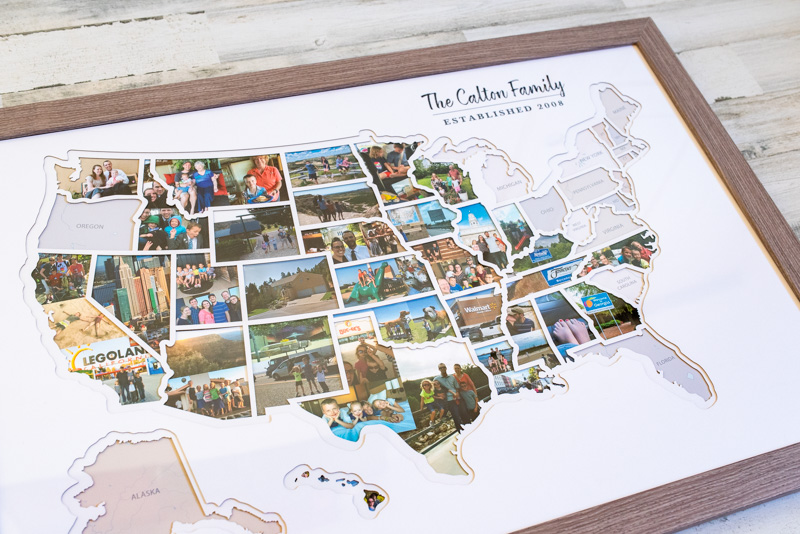
We just got this awesome 50 States Photo Map, to document all our travels as a family. We love it so much! It's a great conversation starter, and pretty much everyone who sees it compliments it.
We've done hours of research, and the Thunder Bunny personalized USA Photo Map is easily the best option. It's the right size, has a very fair price point, and can be personalized by color/font/style. It comes with three different choices of frames that are the perfect depth for their multiple layers of die-cut mats. Best of all, they provide handy software that lets you customize your photos to the exact size and shape you need, and easily send them to a photo printer.
If you're going to make a personalized USA photo map, this is the way to go!
The 50 States Photo Map is available at Amazon , Etsy , and the Thunder Bunny Labs website . I recommend clicking through each to see if they are running a sale on one platform and not the other.
This is a fantastic gift! It could be an anniversary gift for your spouse, or a wedding gift for a new couple, or any kind of birthday or holiday! You can personalize it and wrap it up - your choice if you gather and print the pictures for them, or let them pick their favorites with you.
Read on for all the details about how this personalized USA picture map works.
It's made of 5 layers.
You can personalize it..
- There are 3 different frame styles.
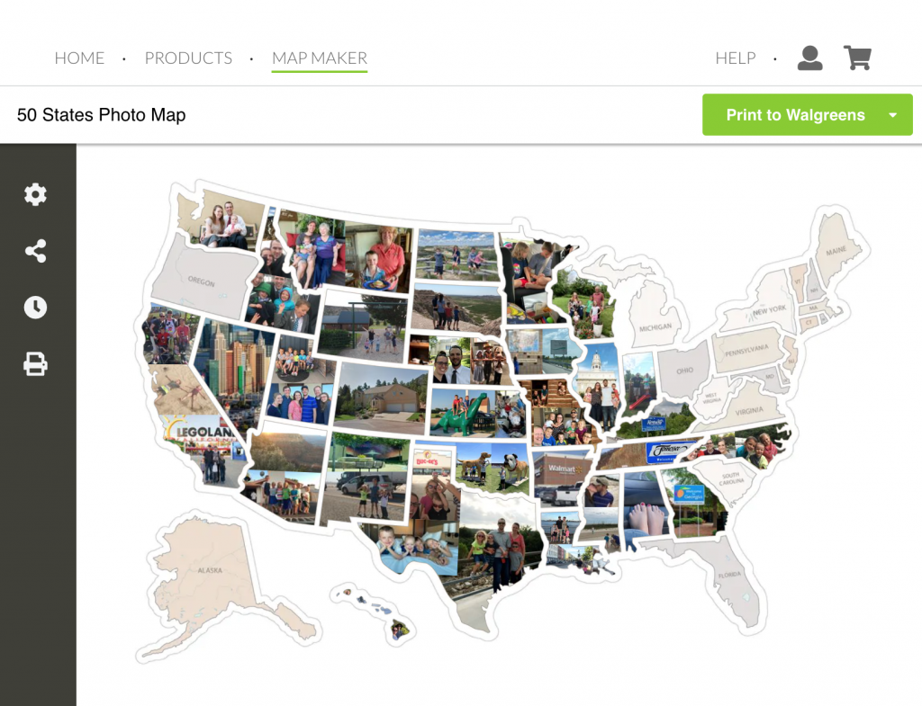
The Thunder Bunny Labs Map Maker
Here's what you need to fill a 50 states photo map:, option 1: estimated cost of using walgreens to print, option 2: use an online printer to save, option 3: photo stickers now available, cutting out and affixing your photos, how big is it, not sure if this is the right option, amazing gift: a 50 states photo map to show off travel pictures.
One of the things that makes this option the best 50 states photo map is that it comes with several layers of mat and background. This adds really nice depth to the overall display, making it look very classy and high-quality.
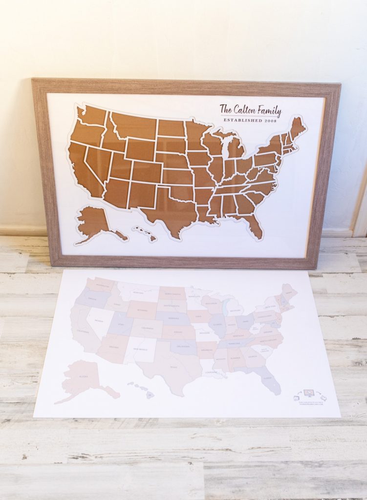
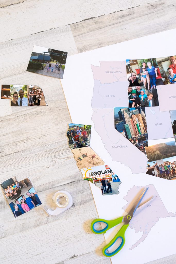
First there's the cardboard layer (#1) that makes everything fit snugly, but this is completely covered by the actual background layer (#2). This layer is printed with the states in neutral colors, which will show until you visit them and add a photo. You'll cut out your states and use double-sided tape to attach the photos to this layer.
Then there is a white die-cut layer (#3) of all the state outlines. The beauty of this layer is that it makes all your states look clean and precise, even if you didn't cut them out perfectly! Some of those states are tricky, with all their jagged edges and river boundaries.
I think that this layer is what makes your finished map look so professional, and what makes the Thunder Bunny 50 States Photo Map way better than the competition.
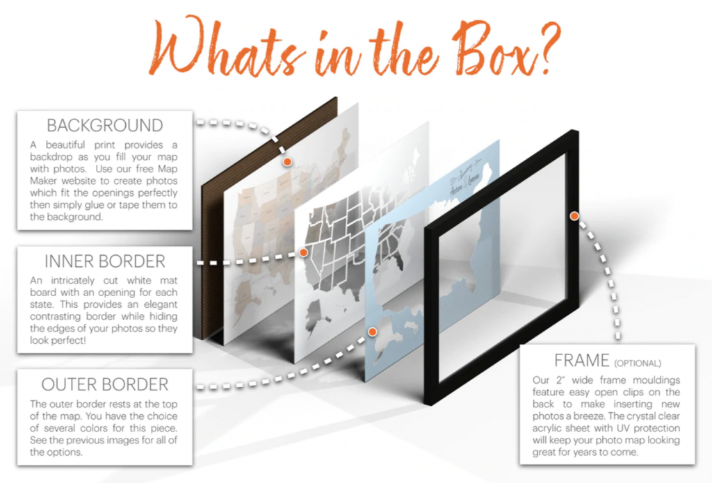
Then there is a laser-cut mat (#4) that just has the outline of the continental US plus Alaska and Hawaii. This mat adds another layer of depth to the finished product, and also comes in several colors!
You can choose from a medium gray (called Driftwood), a medium blue (called Caribbean), a dark green (Zucchini), Sienna, White, or Black. There is also an option that has the bordering states printed on it like an actual map so that Canada and Mexico are visible.
I ended up choosing the white mat since I wanted our pictures to pop against the white color.
Finally, there's a clear acrylic layer (#5) to protect all your photos. This layer comes with lined with plastic on both sides to protect it from any scratches while shipping.
All those layers come super well protected in a shipping box.
Thunder Bunny has 4 options for what style of words you can add to the USA Photo Map. There are different fonts and placements, depending on what you like. Then when you order you just list which numbered style you want and what words those should be.
The personalization is on the top map layer. We got our family name printed on it, to keep track of all the places our family has traveled together.
This is the link for the personalized version from Amazon . This is the link for the personalized version from Etsy .
A personalized US photo map would make a really sweet wedding present for a new couple! You can add their names and wedding year to several of the options.
There are 3 different frame styles .
You can choose a frame from Thunder Bunny in white, black, or weathered gray. It comes super well packaged, with all the corners protected in a big box.
Of course, you can buy this US photo map unframed, but it's much easier to get the frame they have already prepared to fit their product perfectly.
Basically, all these options mean you can absolutely create a personalized USA Photo Map, in whatever color scheme or style you want!
I debated a lot about the frame color and ended up going with the gray frame. I think the black would have been really classy too though!
How Do You Make The Photos Shaped Like A State?
Printing state-shaped photos sounds like it could be a huge headache. Everyone wonders "how do you get the photos in the right shape?"
Don't worry - this company has already solved the problem.
Thunder Bunny offers a map maker on their website, that lets you upload pictures and print them in the exact size you need!
It is truly genius, and the only way I would have undertaken a project like this.
Here's the mapmaker site: https://www.thunderbunnylabs.com/mapmaker
You'll have to make an account, but it's super easy and convenient to have all your pictures available in their software. Then pick your template; I wanted the 50 states picture map template, but you can pick whatever one you're working on.
Then, you click a state and upload the photos you want to put in that state. You can drag and drop a photo into the template, or find it in your files.
The map-maker has functions to scale, rotate, and move your photo around the state template. It makes it super easy to adjust your picture to be the most pleasing in some of those odd shaped states!
You can even add multiple photos to each state to make a collage . (None of their competitors have this ability!) This is super helpful for bigger states like Texas and California, or frankly any of them. You can add up to 10 photos per state.
One of the things I loved was that you can preview what your map looks like as you make it! Each state fills in on your map as you add pictures to it, and everything is saved for each time you print a batch of photos.
That makes it easier to choose between picture options when you can see what states it borders.
For example, you might realize a scenery shot looks better next to a close-up in a bordering state. If you care about aesthetics, this really helps you design a really beautiful 50 States Picture Map.
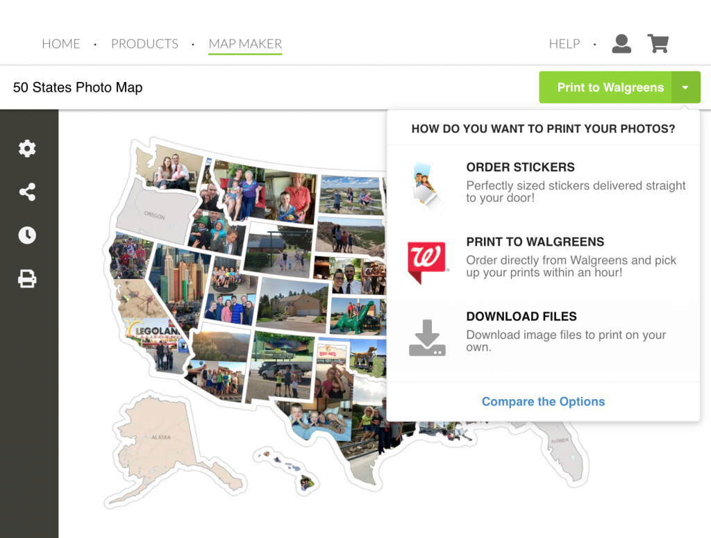
How Much Does It Cost To Print Photos ?
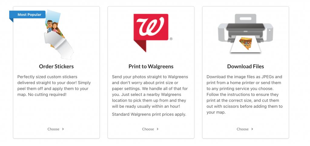
After you've used the map maker, you have three options to fill your US Photo Map.
- You can print your photos at Walgreens using the built-in function
- You can download the files and print them at a printer of your choice.
- Or, their NEW option is to order photo stickers (no cutting necessary!)
Walgreens is obviously super convenient, especially if you want to use same-day pickup. It's a matter of only a few clicks and they go right to Walgreens. (You don't order in the Walgreens website or app - just start in the Thunder Bunny Labs site and it connects it automatically.)
Or, you can just download the files and print them where ever you'd like. To do this, you just click the green Print To Walgreens button and you'll see the dropdown option to download a JPG file.
Either way, you'll need a certain number of 8x10 and 5x7 images to fit the larger states, and then everything else goes on 4x6 prints.
We calculated 3 big 8x10 inch prints (for California, Texas, and Alaska), 8 medium 5x7 inch prints (for the states like Nevada, Montana, Utah, etc), and then 39 more 4x6 inch prints for the smaller states.
One of the things I really like about Thunder Bunny's map maker is that it automatically combines small states onto a 4x6 print if they can fit them. For example, Hawaii fits nicely on a 4x6 print with many different small states like Ohio.
It's cheaper to combine states where you can, but how much money you save just depends on the order you are ready to print your photos.
The Map Maker is automatically set up to print at Walgreens. It's super easy to just click the "send to Walgreens" button and choose your location. You can even use the same-day pickup to get your prints in about an hour!
Your estimated cost would be:
3 Large States x $3.99 = $11.97 8 Medium States x $2.99 = $23.92 <39 Small States x $0.35 = 13.65 Total: $49.54 to print at Walgreens
It's about $50 total to print all the photos you need at Walgreens for your 50 states picture map.
You could also save out your images from the map maker, and then print them somewhere else.
Online printers such as Mpix and Shutterfly usually offer better quality prints and often have sales that make them cheaper than a local big box store.
However, you'll also have to include shipping fees and whether or not you can combine it with other products to hit free shipping.
Your costs will vary here, depending on sales and their pricing. But here's the same scenario at other retailers.
Printing at Mpix (Full Price listed, but there are often sales)
3 Large States (8x10) x $2.99 = $8.97 8 Medium states (5x7) x $1.49 = $11.92 <39 Small state (4x6) x $0.33 = $12.87 Total: $33.97 to print at Mpix.
Printing at Shutterfly (Full Price listed, but there are always sales)
3 Large States (8x10) x $3.95 = $11.85 8 Medium states (5x7) x $0.99 = $7.92 <39 Small state (4x6) x $0.18 = $7.02 Total: $26.79 to print at Shutterfly.
Obviously, it all depends on how many states you're printing, shipping costs, and if you want the convenience of same-day pickup or you're willing to wait. The beauty of it is you can make that decision each time you print states for your USA Picture Map!
Mpix or Shutterfly will give you cheaper prints if you have a lot of large states, so that might be a good option for your first order.
But if you're only printing a few at a time then Walgreens is quite convenient, especially since it's all connected inside the Map Maker system. You choose!
Thunder Bunny Labs now offers printed photo stickers of your photos! It's one of the options in the dropdown. These stickers are precut in the correct size and shape - just peel and stick, no cutting.
The only trick is that stickers change the cost of filling your map considerably. However, it might be worth it for the time and effort of cutting out the states yourself.
Your cost for stickers would be:
5 Large States x $5.00 = $25 35 Medium States x $2.50 = $87.50 10 Small State x $1.25 = $12.50 Total = $125 to fill your map with Thunder Bunny Labs Stickers
So it's 2-3x as expensive as printing photos and cutting them yourself. It's certainly convenient, so if you're not crafty, this might be a good option!
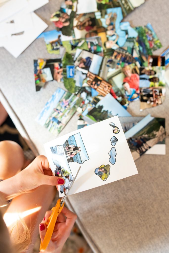
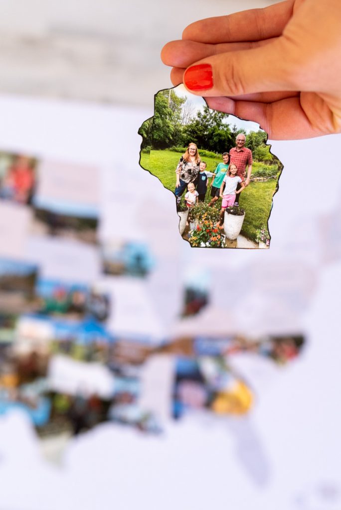
Once the photos were printed, we found it really easy to cut out our images. They are already perfectly sized, so it was just cutting them out on the line!
Since I had a ton of pictures to add at once, we just had a cutting party and got them all done in a few minutes.
One of the beauties of the multiple layers is that you didn't have to be perfect about all those crazy river boundaries! The photos will be sitting behind a die-cut inner "window" layer with all the states, which makes the finished product look super professional.
I didn't cut out individual Hawaii islands either, since the layers would cover that up too.
Then I just laid that bottom state layer on the floor, and used double-sided tape to attach all the photos ...It was way easier than making tape loops! Once your photos are all on the bottom layer, just stack up the layers and carefully slide them into your frame.
This frame is especially awesome because it's deep enough for 5 layers and is very durable, for taking things in and out a lot. Just flip it over and hang your USA picture map. Tada!
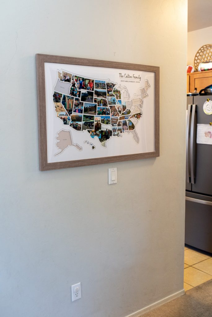
This 50 States Photo Map is 36x48 inches (3 ft by 4 ft). The 5 layers are all the same, and stacked together.
I chose to buy the frame directly from them, and it's high-quality. The included frame adds another two inches on every side, and it comes with heavy-duty hardware already attached. It also has cool clips that make it easy to access the back of the map, to slide your layers in and out.
The Thunder Bunny Labs frame is definitely the best option for a Personalized USA Photo Map. Even if I were to get a different frame on amazon, it's not likely it would be deep enough to handle their 5 different layers: (the cardboard back, the sheet you put the puts on, the cutouts of each state, the cutout of the entire US, and the clear plastic layer.) So I was very pleased with this frame.
Everything comes super well protected in a shipping box. We had no issues with chips, scratches, or anything.
Overall, we were incredibly impressed with our 50 States Photo Map .
We've filled it with photos, and now we're itching to go on a back east trip! Since we're missing a whole lot of states over there. And darn Oregon, for some reason?!
It's been a delight to go through old pictures and reminisce with the kids about all the places they've been (about 30 states for the oldest kids - the younger ones missed a few trips we took before they were born.).
I think a USA picture map like this is an excellent present for someone who loves to travel or WANTS to travel. It's the perfect way to display some adventures and a great conversation starter.
You can buy this USA Photo Map is from Thunder Bunny Labs, which is widely available on Amazon , Etsy , or their own website .
I also did a write-up about other maps I researched, so you can save yourself some time and check that post for two other photo map options are out there .
However, I do believe that the Thunder Bunny Labs US Photo Map is the best pick - you really can't go wrong with the quality and cost!

Reader Interactions
November 22, 2022 at 8:03 am
Thanks for the great write up Meg! We've put a ton of work into our photo map products over the years and it's wonderful to know it helped you create such an amazing photo map. We're always adding new features to the Map Maker and strive to keep making it the absolute best photo map product in the world.
Leave a Reply Cancel reply
Your email address will not be published. Required fields are marked *
Create a travel map for your photobook

Are you looking to create a travel map for your photobook or travel blog? Gathering all the beautiful memories of your travels is a great way to hold on to these valuable experiences. Look back at your journey and adventures with a personally designed map that shows your exact travel route.
With the Printmaps online map editor you can easily draw a route on existing roads on your selected map area. Add points of interest, country and city shapes in different colours and receive a high resolution map, ready for any further editing and print. Learn about the features of the Printmaps editor and how use them.
We’re happy to share some ideas and tips to help you make your travel map as awesome as the trip itself!

Design your photobook travel map with coloured shapes
Add the shape of a country and choose “invert”. This way, with a single click, the surroundings of the country, both water and land, turn to the colour of your choice. For example, you can make them the colour of water (RGB, 173, 255, 209), or white, to separate the country of its neighbouring countries and create a floating effect. With the option to adjust the shape transparency, you can colour countries without losing the display of roads, rivers and mountains. Would you like to create a world map and show all the countries you visited? Give all of them a different colour.

Use different POI markers to pin different trips
You can mark your points of interest with dots, squares or any of the standard shapes provided in the editor. Add a label to the markers or number them to display the chronological order of your trip. Or, display the label without a surrounding marker, like an airplane or a ferry. Mark your favorite restaurants, hikes or beaches. If you can’t find what you’re looking for in the editor, easily upload your own custom markers!
Easily create a route map with the route editor that draws on the exact roads you travelled!

Combine Printmaps to show your travel in world view
If you want to show a close-up of your travel route and a world view with your destination highlighted, then combine two Printmaps! After creating your maps you receive a file that is ready for editing in Photoshop or Illustrator, or any other editing program you might use, to add the finishing touches to the maps and to put them together into your awesome, personalised travel map.
Try Printmaps
Our map-editor lets you create printable maps worldwide in no time.
Share Your trip memories
TraveledMap gives you all the tools you need to share interactive maps, on your website or social networks.
Create, draw and illustrate your trips and itineraries, whether personal or professional, with photos, from a very simple interface to handle.
TraveledMap offers a range of 3 tools

Your online map to share with others thanks to a link
Free (excluding options at $2/month.)

Embedded Map
The turnkey map, integrated directly on your website/blog using 1 line of code.
Monthly subscription starting at $2.99

Trip Itineraries
A show-off of your itineraries on your website.
Available online or in white-label product "à la carte"
What is TraveledMap ?
You are a travel amateur.
and you are looking for a new way to share your adventures ?
With TraveledMap you can simply, for free, and in a flash, create your own map and share it to the world !! Create your interactive map from now, add photos or videos on each step of your road trips or city trips and share it on social networks via a link like this one !
You are a blogger
relentless and passionate about traveling ?
Speed things up by easily integrating into your site interactive maps or even driving directions customized by yourself. Whether it's about integrating a travel map or itineraries into your articles, a multitude of customization options are available, and the integration into your site is done by a simple line of code , or via the use of a WordPress plugin !
You are a tourism professional
and you are trying to create the "wow" effect when you propose a destination or an itinerary ?
We offer to make the product sheet of your tours evolve by considering your graphic constraints and the particularities of your escape promise (agencies/tourist offices/tour operators/communities, etc.). Increase the interactivity of your site through the help of maps and help the visitor to project himself into the trips you propose !
3 tools developed to simplify your life
Online map : your online map to share with others thanks to a link.
TraveledMap Online Map is a free, very easy to use tool to share your trip memories! By using it, you create your own interactive map of a new kind and add your trips . Whether it's a road trip or a single destination, add your favorite photos which will be accessible with a simple click, all in the style that suits you.
For Road Trips and City Tours , you have the option of detailing the trip by adding the different steps , their own pictures as well as the routes taken, for a very visual result, bringing a geographical dimension to your photos.
The little extras : Display the countries you have visited, and also upload videos if you prefer this format to present your trips !
Embedded Map : The turnkey map, integrated directly on your website/blog using 1 line of code
With Embedded Map , choose to embed maps directly on your website. How ? The TraveledMap team has managed to make this integration possible with a single line of code ! Good to know : it can also be done by using a WordPress plugin.
Create a map of your travels (or any other accomplishments) and, with embedded, clickable location markers, redirect your visitors to the link of your choice (a blog post for example).
Particularly, Embedded Map allows your visitors to find your articles by destination faster by offering a geographic search.
The advantages ? Each marker owns a name and is customizable to your pleasing (color, size, icon). Add photos or videos that are also accessible with a single click! Other customization options are also available, such as the choice of map background, the center and initial zoom of the map, the level of markers clustering, the tilt of the map, etc.
Trip itineraries : A show-off of your itineraries on your website
Trip Itineraries allows you to highlight your travel itineraries, whether you are Tourism professional or blogger .
Once your trip is created on TraveledMap (by yourself, or by our team, if needed), you can embed it on the page of your site (or platform/software) dedicated to it or on a blog post. Thus, you have an interactive map containing the tour's stage markers as well as the routes taken.
This map is one of a kind since its designed to follow the scrolling of the page (the scroll) and target the showed step at that level. Moreover, the itinerary presentation maps have been designed to make the photos of the trip accessible in order to catch the visitor's eye and allow him to project himself. What better way to already see yourself there !
The advantages ? The white label ! For tourism professionals, this tool is available in white label, integrated to your website or on a dedicated website , which allows you to adapt your technical issues to your needs for additional features and make it a unique product on the market.
To summarize, the TraveledMap tools are...
Customizable, easy to use, do you need more information .
Visit the pages dedicated to your specific needs, or contact us at [email protected]
Where Your Travel Memories Come to Life
The Better Way to Share Your Travel Memories
Wow your friends with an animated travel map .
Check out one of our animated travel maps created with PictraMap®!
Why is this the tool that you've been waiting for ...
No credit card required, create your first animated travel map within minutes.
It's different
WOW your friends and get them talking about you and your travels.
It's all you want
Free online tool to create animated maps from travel photos. Ain't that right?
No wait time
The tool is entirely web-based - you register and get instant access to the system. Create your first animated travel map within minutes!
Beautiful maps
It is not yet another tool with Google maps, offering the same old same old map layout. Find the map that matches your taste and type of trip.
Customization
No other online tool offers so many customization options - you choose the map, pins, intro, ending, music theme, not to mention the color options.
Easy to use
You don't need any tutorial because of the super-easy interface - register and within minutes, you can have your first animated travel map.
Easy to share
Because it's all online, you can always share your animated travel maps with the world - on Facebook, via email, even embed it on your blog.
It just is ...
Passionate travelers badly needed such a tool (we know, they told us so). Be among the first to create an animated travel map with PictraMap®!
Are you ready to be a pioneer? Dare to be different?
What passionate travelers say about pictramap®.

I was pleasantly surprised of what I saw when a friend shared the link to PictraMap. The unique way I can create and share my albums there lets my friends and family enjoy the fun moments of my trips. I like the flexibility and variety of the maps, the transitions between locations, and the music scores I can choose from – all in a very quick and intuitive way. Thank you, guys!

What a great way to give life to my countless otherwise boring photos! The maps, the music, the colors make every album special and help add an emotion to it. It's easy to use and the result is a fun adventure I could share with all my friends and family! I know they will love it too!!
Busy? No problem - we'll remind you!
If you're too busy to create your first animated travel map right now, or you think your friends can wait being WOW-ed by your last amazing trip, join our community. We'll remind you later that your travel photos can still get the attention they deserve 😉
Browse Site
- Start Here!
- Plans & Pricing
- Log in to PictraMap
- Create an account
From The Blog
- Convert PictraMap Animations to Videos: Built-in Feature Released
- Search by GPS Coordinates, Full HD Pics and New Maps Released
- New Customization Options Now Available in the ‘Extras’ Tab
Get in Touch
Want updates via email.
- Northern Ireland
- Couchsurfing
- Miscellaneous
- Bucket List
- Who is Penelope?
The Most Beautiful Stations on the Moscow Metro
You might have heard that there are some beautiful metro stations in Moscow. Soviet decorations, chandeliers, mosaic painting and statues are common in many of the stations. The good news is that the Moscow Metro does not cost a lot of money and many of the most beautiful stations on the Moscow metro are on the same line, so you can almost get on and off at each station to visit these. Over the New Year holidays, I had a free afternoon and decided to visit some of these stations. Check out what I found below…..
The main stations that you will want to visit are on the Number 5 line, also known as the Circle Line. An advantage of this line is that you can get to it very easily and quickly no matter where you are in Moscow. The announcements on the metro are in Russian as well as English so you don’t need to worry if your Russian language skills are not good.
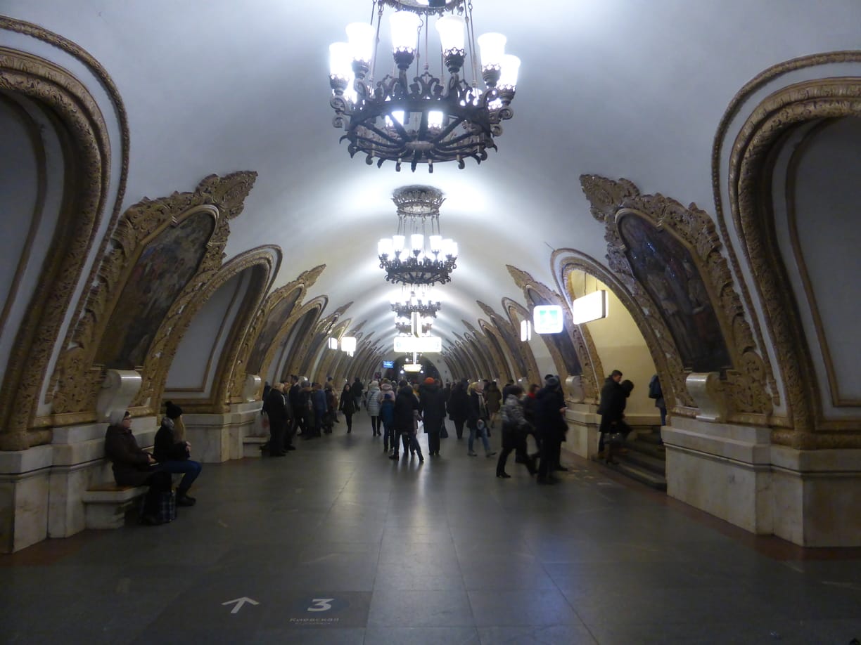
If, like me, you arrive in Moscow via train from Kyiv , then you will arrive at a metro station which many Muscovites believe to be the most beautiful of them all…..
Kievskaya metro station was opened in 1954 and features white marble walls which curve upwards and have with large mosaics surrounded by a gold trim in a very classical style. The mosaics depict life in Ukraine and was designed by a Ukrainian who wanted to display Ukraine’s influence and contribution to Soviet Russia.

Kievskaya, one of the most beautiful stations on the Moscow metro

Soviet era artwork between the arches

Mosaic with golden trim

People carrying flags is a common theme

Going into battle
Belorusskaya
If you look at a map of the metro , you will want to go in a clockwise direction on the circle line. So you will want to get on the train going in the Barrikadnaya direction and not Park Kultury. Stay on this line until you reach the 2nd station, Belorusskaya. This station was built in 1952 and like Kievskaya also features white marble pylons and a plaster ceiling.
The ceiling features 12 mosaics in an octagonal shape depicting Belarusian life, while the tiling on the floor is said to resemble a Belarusian quilt. One of the passageway exits of the station has a statue called ‘Belarusian Partisans’ of three men wearing long coats, holding guns and carrying a flag.”

Belorusskaya metro platform

Soviet artwork on the roof

The hammer and sickle features prominently in the metro artwork

Three men carrying guns, holding the flag…
Mayakovskaya
To get to the next station, we need to change onto the green line (line 2) and go just one stop to the station of Mayakovskaya. This station has an art deco theme and, for some, resembles an elaborate ballroom. The columns are faced with stainless steel and pink rhodonite while the marble walls and ceiling have 34 mosaics with the theme “24-hour Soviet Sky. Apparently, Stalin resided here during the 2nd World War as the station was used as a command post for Moscow’s anti-aircraft regiment.

Mayakovskaya metro

24-Hour Soviet Sky mosaic

Bomber planes

It looks like planes flying over Red Square

Novoslobodskaya
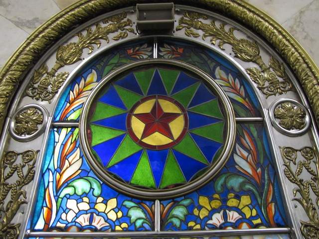
It’s time to get back on the metro and return to Belorusskaya. At Belorusskaya, change to the circle line again and continue clockwise to the next station, Novoslobodskaya. With its 32 stained glass panels, this station reminds me of a church. The panels were designed by Latvian artists and are surrounded by a brass border.

Novoslobodskaya metro

The platform of Novoslobodskaya metro

Stained glass artwork

The golden trim around artwork is also very common

Prospekt Mira
Back on the metro and again just one stop until our next station, Prospekt Mira. This station was originally called Botanichesky Sad after the nearby Botanical Gardens of the Moscow State University. The pylons are covered in white marble and decorated with floral bas-relief friezes. The ceiling is decorated with casts and several cylindrical chandeliers.

Prospekt Mira metro station

Notice the floral decoration
Komsomolskaya
On the metro once more and once more we are going just one stop to the next station – Komsomolskaya. This station is famous for its its yellow ceiling. The chandeliers in this station are huge. The photos below do not do this station justice. For me, this station resembles a presidential palace. You hace to see it for yourself to truly appreciate it.
Because of it’s location, this is one of the busiest stations in the Moscow metro as it serves three of the main train stations in the city – Leningradsky, Yaroslavsky, and Kazansky so be prepared for a lot of people.

Komsomolskaya metro

The yellow ceiling seems to go on forever

Yellow ceiling and artwork

One of the ceiling mosaics
Elektrozavodskaya
When you are ready to leave Komsomolskaya metro station behind, then get back on the circle line and go one stop to Kurskaya and change to the blue line (line 3) and go to two stops to the Elektrozavodskaya station. This station gets it’s name from a nearby electric light bulb factory and has a somewhat industrial but also futuristic style, with 6 rows of circular lamps (there are 318 lamps in total). I think this is one of the most beautiful stations on the Moscow metro for how unique it is. The station was opened in 1944 after a delay because of the 2nd World War and features 12 marble bas-reliefs of the struggle on the home front during the war.

The Komsomolskaya metro station

The struggles of war at home

Fixing machinery

Hard at work

Making weapons

Building a tank

Even the station sign is elaborate
Ploschad Revolyutsii
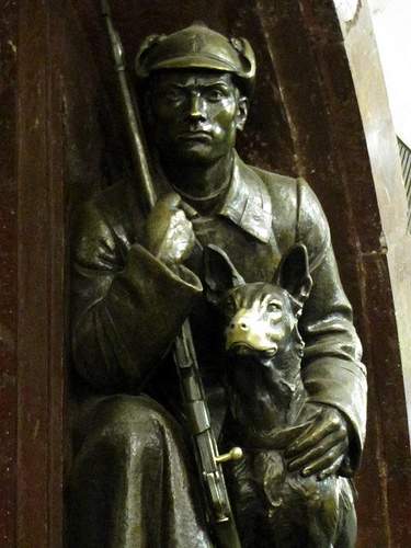
Back on the metro line 3 (but in the other direction), getting off at the 3rd stop – Ploschad Revolyutsii (Revolution Square). This is located underneath the square in Moscow of the same name and is a short walk from Red Square in the city centre. It is the perfect place to end a visit around Moscow’s metro. The station features red and yellow marble arches with a total of 76 sculptures in between each arch. The sculptures are supposed to represent the people of the Soviet Union and include soldiers, farmers, industrial workers, children etc… I noticed a lot of people touching the golden chicken in the photo below as well as the show of the woman. I am assuming that this is for good luck.

Industrial worker

Touch the chicken for good luck

Sculpture of the people of the Soviet Union

Woman reading a book – touch the shoe for good luck

In education

Parent and child
These are some of what I think are the most beautiful stations on the Moscow metro. Which ones are your favourite? Would you add any to this list?
You Might Also Like

The Oldest Whiskey Distillery in the World

Kjeragbolten: Scary, Exhausting and Exciting!
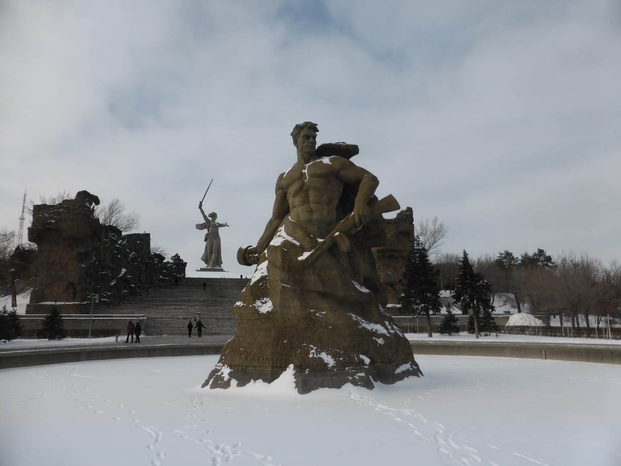
Mamayev Kurgan Memorial in Volgograd
19 comments.

Kievskaya definitely caught me off guard. Didn’t know Moscow metro stations were THIS extravagant! Mayakovskaya is gorgeous too with the marble walls and mosaics. I might just need to book a flight over to admire all of these!

Do it! Kievskaya was my first introduction to the Moscow metro as I got an overnight train from Kyiv.

You know, in the States, all we ever hear is bad stuff about Russia. It’s nice to see other (and lovely!) dimensions of such a controversial place.
It’s the same in the UK which is why I prefer going to see somewhere and making up my own mind. It’s all ‘politics and bullshit’ as I say

I went to Moscow about 13years for Christmas and went to train stations, so I can see these amazing mosaics and chandeliers. I agree with you that are beautiful Stations for sure and I could of wandered around for days. I think Kievskaya is definitely my favourite out of them all and I even have some similar pictures as you.
I imagine Moscow would have been a little different 13 years ago but these stations have probably always looked beautiful

Food and Footprints
You chose some great stations for this write up! Beautiful details in these stations and would love to visit them sometime. Particularly like the Komsomolskaya station with that yellow ceiling!
Thank you very much. Komsomolskaya seems to be a lot of peoples favourite stations too

Sumit Surai
Wow! Without the text I would have thought them to be some museum or gallery.
I know exactly what you mean!

Rosie Fluskey
Wow, it is just stunning! How does anyone get to work with so much to look at. I’m surprised at the very bourgeois-looking Komsomolskaya station. I would have thought it was all too Tzarist looking, but then I haven’t been to Russia yet lol. This has just made me want to go more!

Wow, that’s a lot of artwork. I wonder how old some of these pieces are?
Generally most of the stations are from 1940-1960 approximately. The later stations are more functional than style.

My mother-in-law was in Moscow fifty years ago and still raves about the metro stations. So far, I could not imagine much. But now! The pictures are great and I think it’s almost a pity that this splendor is underground. But for every user of the Metro can enjoy a free trip to the world of art. Susanne
True. It is like having a free trip to an art museum/gallery. I hope that you can one day visit Moscow and see for yourself.

Oh wow, I would never have known that these were metro stations. The ceilings remind me of how you need to look up sometimes, even in the commuter rush!
It is true about life in general, we just go from A to B looking directly in front of us instead of around us

Wow, I would have never guessed that these were stations. The decor is so pretty and not one I’m used to seeing at metro stations. Love the ceiling at The Komsomolskaya metro station.
They certainly don’t look like metro stations. The ceiling there is one of my favourites too!
Leave a Reply Cancel Reply
Save my name, email, and website in this browser for the next time I comment.
Notify me via e-mail if anyone answers my comment.
- Vacation Rentals
- Restaurants
- Things to do
- Elektrostal Tourism
- Elektrostal Hotels
- Elektrostal Bed and Breakfast
- Flights to Elektrostal
- Elektrostal Restaurants
- Things to Do in Elektrostal
- Elektrostal Travel Forum
- Elektrostal Photos
- Elektrostal Map
- All Elektrostal Hotels
- Elektrostal Hotel Deals
- Elektrostal Hostels
- Elektrostal Business Hotels
- Elektrostal Family Hotels
- Elektrostal Spa Resorts
- 3-stars Hotels in Elektrostal
- Elektrostal Hotels with Banquet hall
- Elektrostal Hotels with Game room
- Hotels near Electrostal History and Art Museum
- Hotels near Park of Culture and Leisure
- Hotels near Statue of Lenin
- Hotels near Museum and Exhibition Center
- Hotels near Museum of Labor Glory
- Hotels near (ZIA) Zhukovsky International Airport
- Hotels near (VKO) Vnukovo Airport
- Hotels near (DME) Domodedovo Airport
- Disney's Caribbean Beach Resort
- Xafira Deluxe Resort & Spa
- Excalibur Hotel & Casino
- Giraffe Manor
- Jules Undersea Lodge
- Aruba Ocean Villas
- Royalton Riviera Cancun
- Disney's Animal Kingdom Lodge
- Hilton Hawaiian Village Waikiki Beach Resort
- Disney's All-Star Movies Resort
- Secrets Cap Cana Resort & Spa
- Hyatt Ziva Cap Cana
- Luxor Hotel & Casino
- Grand Hyatt Baha Mar
- Ocean Casino Resort
- Popular All-Inclusive Resorts
- Popular Beach Resorts
- Popular Family Resorts
- Popular All-Inclusive Hotels
- Popular Hotels With Waterparks
- Popular Honeymoon Resorts
- Popular Luxury Resorts
- Popular All-Inclusive Family Resorts
- Popular Golf Resorts
- Popular Spa Resorts
- Popular Cheap Resorts
- All Elektrostal Restaurants
- Restaurants near Restaurant Globus
- Cafés in Elektrostal
- Chinese Restaurants in Elektrostal
- European Restaurants for Families in Elektrostal
- European Restaurants for Large Groups in Elektrostal
- European Restaurants for Lunch in Elektrostal
- Fast Food Restaurants in Elektrostal
- French Restaurants in Elektrostal
- Italian Restaurants in Elektrostal
- Japanese Restaurants in Elektrostal
- Pizza in Elektrostal
- Russian Restaurants in Elektrostal
- Seafood Restaurants in Elektrostal
- Vegetarian Restaurants in Elektrostal
- GreenLeaders
- Elektrostal
- Things to Do
- Travel Stories
- Rental Cars
- Add a Place
- Travel Forum
- Travelers' Choice
- Help Center
- Europe
- Russia
- Central Russia
- Moscow Oblast
- Elektrostal
- Elektrostal Restaurants
Restaurant Globus
Ratings and reviews, location and contact, restaurant globus, elektrostal - restaurant reviews & photos - tripadvisor.
MyMap:Easily save location 4+
Shareable with friends., kazunori wakamatsu, designed for ipad.
- Offers In-App Purchases
Screenshots
Description.
This is a map app that allows you to easily manage and save location information. Location information can be shared with friends and work colleagues. Easily register and manage location information on a map with this map app. Use it to record "restaurants," "travel destinations," "business clients," "memorable places," and more. You can attach an unlimited number of photos to each location! ------------------------------------------------ Features of My Map ------------------------------------------------ 1. Easy Registration of Location Information! You can attach detailed text and photos to the registered locations. To register, simply long-press on the desired location on the map. Keep important information and memories with texts and photos! 2. Register Locations from Searches! Search for locations using free text, and register them directly. If the place is a store, the store's website URL and phone number will be automatically registered. Temporarily register any store you like! This way, you can easily access the website or make a call anytime. 3. Route Search to Locations! Search for routes from registered locations. You can select the starting point from your current location or another registered location. Never get lost on your way to your destination again! 4. Categorize Location Information Categories can be freely added. You can toggle the display of location information by category. Even as you register more locations, you can temporarily hide categories you don't need to see. 5. Freely Set the Color of Location Markers You can set colors for markers by category. Even as you add more locations, it's clear at a glance on the map what type of locations they are! 6. Save Data on the Cloud By registering an account and logging in, you can save your data in the cloud. This allows for seamless continued use, even when changing devices. 7. Share Registered Locations with Family, Friends, and Colleagues Sharing can be set by category. You can choose between "view only" and "editable" for sharing. Share travel plans and memories with your family! Share customer information with your colleagues! ------------------------------------------------ User Feedback ------------------------------------------------ Female in her 20s: "I use it to register restaurants I want to visit!" Male in his 40s: "I've registered all my valued customers." Male in his 30s: "I use it to keep travel memories." ------------------------------------------------ Frequently Asked Questions ------------------------------------------------ Q. My map is cluttered because I've registered too many locations. A. You can categorize location information and choose whether to display each category on the map. Use this feature to toggle the display of relevant categories as needed. Q. Is there a limit to the number of photos I can attach? A. There's no limit to the number of photos you can attach. Feel free to add as many as you like! Q. I want to know how to get to a registered location. A. Use the route search feature from the location information dialog. You can search for routes from your current location or another registered location. More features are coming soon. Please enjoy using My Map! Terms of Use https://www.apple.com/legal/internet-services/itunes/dev/stdeula/ Privacy Policy https://doc-hosting.flycricket.io/maidi-tu-privacy-policy/45bf0659-caf5-4ed7-9b59-4e88a6d8d032/privacy
Version 1.9.4
Now available in German!
App Privacy
The developer, KAZUNORI WAKAMATSU , indicated that the app’s privacy practices may include handling of data as described below. For more information, see the developer’s privacy policy .
Data Not Collected
The developer does not collect any data from this app.
Privacy practices may vary, for example, based on the features you use or your age. Learn More
Information
- Premium plan (1 month) $0.99
- Premium plan (6 months) $4.99
- Premium plan (annual) $4.99
- App Support
- Privacy Policy
You Might Also Like
ONE to Ride
Get Location - Share and Find
OsmAnd Maps Travel & Navigate
GPSPlus - GPS EXIF Editor
Q Ticketing
- Articles >
The Moscow Metro Museum of Art: 10 Must-See Stations
There are few times one can claim having been on the subway all afternoon and loving it, but the Moscow Metro provides just that opportunity. While many cities boast famous public transport systems—New York’s subway, London’s underground, San Salvador’s chicken buses—few warrant hours of exploration. Moscow is different: Take one ride on the Metro, and you’ll find out that this network of railways can be so much more than point A to B drudgery.
The Metro began operating in 1935 with just thirteen stations, covering less than seven miles, but it has since grown into the world’s third busiest transit system ( Tokyo is first ), spanning about 200 miles and offering over 180 stops along the way. The construction of the Metro began under Joseph Stalin’s command, and being one of the USSR’s most ambitious building projects, the iron-fisted leader instructed designers to create a place full of svet (radiance) and svetloe budushchee (a radiant future), a palace for the people and a tribute to the Mother nation.
Consequently, the Metro is among the most memorable attractions in Moscow. The stations provide a unique collection of public art, comparable to anything the city’s galleries have to offer and providing a sense of the Soviet era, which is absent from the State National History Museum. Even better, touring the Metro delivers palpable, experiential moments, which many of us don’t get standing in front of painting or a case of coins.
Though tours are available , discovering the Moscow Metro on your own provides a much more comprehensive, truer experience, something much less sterile than following a guide. What better place is there to see the “real” Moscow than on mass transit: A few hours will expose you to characters and caricatures you’ll be hard-pressed to find dining near the Bolshoi Theater. You become part of the attraction, hear it in the screech of the train, feel it as hurried commuters brush by: The Metro sucks you beneath the city and churns you into the mix.
With the recommendations of our born-and-bred Muscovite students, my wife Emma and I have just taken a self-guided tour of what some locals consider the top ten stations of the Moscow Metro. What most satisfied me about our Metro tour was the sense of adventure . I loved following our route on the maps of the wagon walls as we circled the city, plotting out the course to the subsequent stops; having the weird sensation of being underground for nearly four hours; and discovering the next cavern of treasures, playing Indiana Jones for the afternoon, piecing together fragments of Russia’s mysterious history. It’s the ultimate interactive museum.
Top Ten Stations (In order of appearance)
Kievskaya station.
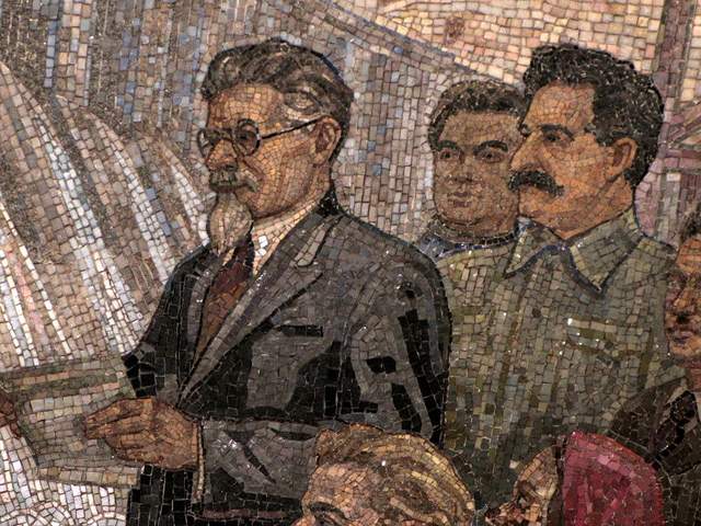
Kievskaya Station went public in March of 1937, the rails between it and Park Kultury Station being the first to cross the Moscow River. Kievskaya is full of mosaics depicting aristocratic scenes of Russian life, with great cameo appearances by Lenin, Trotsky, and Stalin. Each work has a Cyrillic title/explanation etched in the marble beneath it; however, if your Russian is rusty, you can just appreciate seeing familiar revolutionary dates like 1905 ( the Russian Revolution ) and 1917 ( the October Revolution ).
Mayakovskaya Station
Mayakovskaya Station ranks in my top three most notable Metro stations. Mayakovskaya just feels right, done Art Deco but no sense of gaudiness or pretention. The arches are adorned with rounded chrome piping and create feeling of being in a jukebox, but the roof’s expansive mosaics of the sky are the real showstopper. Subjects cleverly range from looking up at a high jumper, workers atop a building, spires of Orthodox cathedrals, to nimble aircraft humming by, a fleet of prop planes spelling out CCCP in the bluest of skies.
Novoslobodskaya Station
Novoslobodskaya is the Metro’s unique stained glass station. Each column has its own distinctive panels of colorful glass, most of them with a floral theme, some of them capturing the odd sailor, musician, artist, gardener, or stenographer in action. The glass is framed in Art Deco metalwork, and there is the lovely aspect of discovering panels in the less frequented haunches of the hall (on the trackside, between the incoming staircases). Novosblod is, I’ve been told, the favorite amongst out-of-town visitors.
Komsomolskaya Station
Komsomolskaya Station is one of palatial grandeur. It seems both magnificent and obligatory, like the presidential palace of a colonial city. The yellow ceiling has leafy, white concrete garland and a series of golden military mosaics accenting the tile mosaics of glorified Russian life. Switching lines here, the hallway has an Alice-in-Wonderland feel, impossibly long with decorative tile walls, culminating in a very old station left in a remarkable state of disrepair, offering a really tangible glimpse behind the palace walls.
Dostoevskaya Station
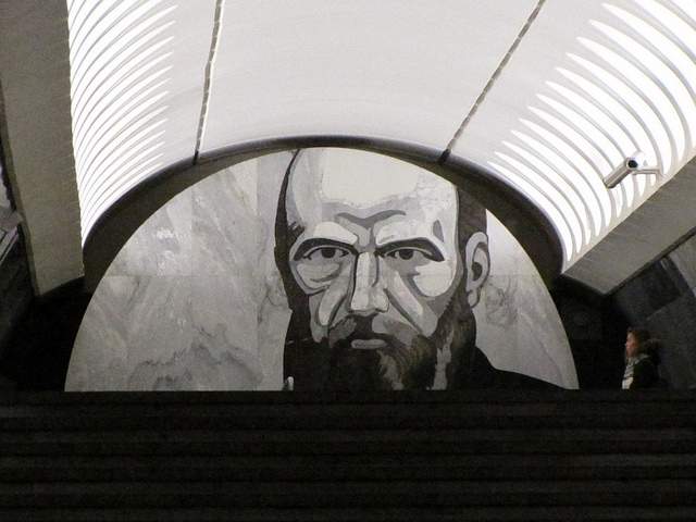
Dostoevskaya is a tribute to the late, great hero of Russian literature . The station at first glance seems bare and unimpressive, a stark marble platform without a whiff of reassembled chips of tile. However, two columns have eerie stone inlay collages of scenes from Dostoevsky’s work, including The Idiot , The Brothers Karamazov , and Crime and Punishment. Then, standing at the center of the platform, the marble creates a kaleidoscope of reflections. At the entrance, there is a large, inlay portrait of the author.
Chkalovskaya Station
Chkalovskaya does space Art Deco style (yet again). Chrome borders all. Passageways with curvy overhangs create the illusion of walking through the belly of a chic, new-age spacecraft. There are two (kos)mosaics, one at each end, with planetary subjects. Transferring here brings you above ground, where some rather elaborate metalwork is on display. By name similarity only, I’d expected Komsolskaya Station to deliver some kosmonaut décor; instead, it was Chkalovskaya that took us up to the space station.
Elektrozavodskaya Station
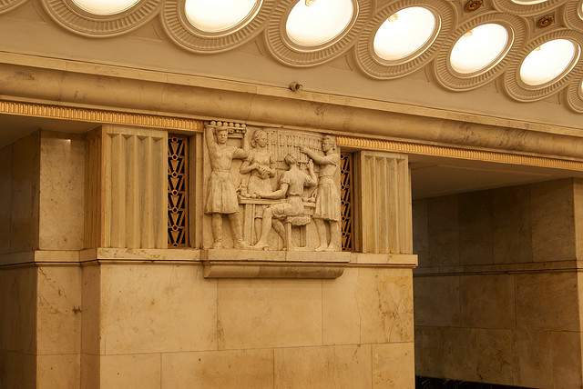
Elektrozavodskaya is full of marble reliefs of workers, men and women, laboring through the different stages of industry. The superhuman figures are round with muscles, Hollywood fit, and seemingly undeterred by each Herculean task they respectively perform. The station is chocked with brass, from hammer and sickle light fixtures to beautiful, angular framework up the innards of the columns. The station’s art pieces are less clever or extravagant than others, but identifying the different stages of industry is entertaining.
Baumanskaya Statio
Baumanskaya Station is the only stop that wasn’t suggested by the students. Pulling in, the network of statues was just too enticing: Out of half-circle depressions in the platform’s columns, the USSR’s proud and powerful labor force again flaunts its success. Pilots, blacksmiths, politicians, and artists have all congregated, posing amongst more Art Deco framing. At the far end, a massive Soviet flag dons the face of Lenin and banners for ’05, ’17, and ‘45. Standing in front of the flag, you can play with the echoing roof.
Ploshchad Revolutsii Station
Novokuznetskaya Station
Novokuznetskaya Station finishes off this tour, more or less, where it started: beautiful mosaics. This station recalls the skyward-facing pieces from Mayakovskaya (Station #2), only with a little larger pictures in a more cramped, very trafficked area. Due to a line of street lamps in the center of the platform, it has the atmosphere of a bustling market. The more inventive sky scenes include a man on a ladder, women picking fruit, and a tank-dozer being craned in. The station’s also has a handsome black-and-white stone mural.
Here is a map and a brief description of our route:
Start at (1)Kievskaya on the “ring line” (look for the squares at the bottom of the platform signs to help you navigate—the ring line is #5, brown line) and go north to Belorusskaya, make a quick switch to the Dark Green/#2 line, and go south one stop to (2)Mayakovskaya. Backtrack to the ring line—Brown/#5—and continue north, getting off at (3)Novosblodskaya and (4)Komsolskaya. At Komsolskaya Station, transfer to the Red/#1 line, go south for two stops to Chistye Prudy, and get on the Light Green/#10 line going north. Take a look at (5)Dostoevskaya Station on the northern segment of Light Green/#10 line then change directions and head south to (6)Chkalovskaya, which offers a transfer to the Dark Blue/#3 line, going west, away from the city center. Have a look (7)Elektroskaya Station before backtracking into the center of Moscow, stopping off at (8)Baumskaya, getting off the Dark Blue/#3 line at (9)Ploschad Revolyutsii. Change to the Dark Green/#2 line and go south one stop to see (10)Novokuznetskaya Station.
Check out our new Moscow Indie Travel Guide , book a flight to Moscow and read 10 Bars with Views Worth Blowing the Budget For
Jonathon Engels, formerly a patron saint of misadventure, has been stumbling his way across cultural borders since 2005 and is currently volunteering in the mountains outside of Antigua, Guatemala. For more of his work, visit his website and blog .

Photo credits: SergeyRod , all others courtesy of the author and may not be used without permission
Subways of Europe Photo Series
- Station Search
- Photo Calendar 2019
- Legal & Privacy

- About Chandra
- Field Guide
- Photo Album
- Resources & Multimedia
- Video Series
- High Res (136.2 MB)
- Low Res (32.3 MB)
- High Res (46.4 MB)
- Low Res (31.5 MB)
- Office Products
- Office & School Supplies
- Education & Crafts
- Geography Materials
Image Unavailable

- To view this video download Flash Player

USA Photo Map - Travel Map Sticker Collage - 24 x 36” - Made in USA (Dark Blue, No Frame)

Purchase options and add-ons
About this item.
- TURN YOUR PHOTOS INTO STICKERS - The only photo map around where you can upload your photos to create stickers which fit the map perfectly. No printing or cutting required!
- 50 STATES PHOTO MAP - Catalog your wanderlust by adding your own photos from every state in the USA! The 50 States photo map is perfect for the avid traveler who wants a creative way to display their travel photos as they visit each of the 50 States.
- ADDING PHOTOS TO YOUR MAP - Our online tool allows you to easily upload your photos, resize and rotate them so they perfectly fit into every state. When you are ready you can order pre-cut photo stickers ready to place directly on your map. Simply peel and stick them onto your map. You can continue to add more photos over time as you travel to new and exciting places!
- SIZING INFORMATION - The map is 24x36" and will also fit in most standard 24x36" frames. Every map is printed in house on a state of the art synthetic film that will stand the test of time.
Additional Details

Customer ratings by feature
Frequently bought together.

Similar items that may deliver to you quickly

From the brand

We're like you. We like to travel. We like to take pictures. But why are all of those memories gathering dust on a server somewhere?
Great adventures are worth celebrating. That is why we created the original photo map.
Since our original photo maps, we've painstakingly improved every single part of the process. It's now easier than ever to fill up your own photo map!

Other Products
Visit the Store

All of our products are manufactured at our facility in Madison Heights, Michigan.
If you are ever in the area, feel free to stop by and say hello!

Product Description

Videos for this product

Click to play video

The ULTIMATE photo map - Here's Why
✅ 5 Towaways ✅ - Travel and Family
USA Photo Map
Looking for specific info, product information, warranty & support, compare with similar items, customer reviews.
Customer Reviews, including Product Star Ratings help customers to learn more about the product and decide whether it is the right product for them.
To calculate the overall star rating and percentage breakdown by star, we don’t use a simple average. Instead, our system considers things like how recent a review is and if the reviewer bought the item on Amazon. It also analyzed reviews to verify trustworthiness.
Customers say
Customers like the stickers on the map. They say it's easy to add stickers and a great gift. They also like the quality and appearance of the map, saying it'll make a memorable gift. However, some customers find the size difficult to fit images and some of the states are tiny.
AI-generated from the text of customer reviews
Customers are satisfied with the quality of the map. They mention that it's durable, sturdy, and made out of a vinyl material. They also appreciate the high-quality stickers. Overall, customers say that it is the best map to keep track of travels and the most aesthetic way.
"...and fitting pictures on the website is very easy and the stickers are very high quality ...." Read more
" Very good quality material and very durable. The simplicity to add stickers makes it even better. It made a great gift!" Read more
"Nice and neat way to record your visits across the country and custom stickers are cool if you order with site." Read more
"...I came across this and I promise you it is so much better, the quality is great . The fun of putting it all together is even better highly recommend." Read more
Customers find the wall art easy to use. They say it's easy to hang, put on, and upload pictures.
"...The process of picking and fitting pictures on the website is very easy and the stickers are very high quality...." Read more
"My girlfriend loves it! Says the upload of pictures are very easy to do ! Can’t wait to see the full map completed!!..." Read more
"...I already ordered stickers from the website and it was easy to use and stickers were affordable...." Read more
" Easy to hang took 1 min " Read more
Customers find the appearance of the map very cool, nice, and neat. They also say it's a great way to display adventures together.
" Nice and neat way to record your visits across the country and custom stickers are cool if you order with site." Read more
"...He loved it! Material of the map is very thick and nice . I ordered the stickers from the company and it was quick to come in. Easy to put on...." Read more
"...Such a great way to display our adventures together !" Read more
" Very cool ..." Read more
Customers find the wall art a perfect gift.
"...The simplicity to add stickers makes it even better. It made a great gift !" Read more
"This was a perfect gift for my daughter . She loves to travel...." Read more
"...pictures. It was a great value for the money and a nice memorable gift ." Read more
" Wonderful gift ..." Read more
Customers find the wall art to be a great value for the money. They say the stickers are affordable and the product is easy to use.
"...ordered stickers from the website and it was easy to use and stickers were affordable ...." Read more
"I gifted this to my husband for Christmas and it was well worth it . He loved it! Material of the map is very thick and nice...." Read more
"...I still use the Photomaps website to print the pictures and they are fairly cheap (I believe $2.50 each)...." Read more
"...pictures. It was a great value for the money and a nice memorable gift." Read more
Customers like the stickers. They say the simplicity to add stickers makes it even better. They also say the custom stickers are cool and easy to order.
"Very good quality material and very durable. The simplicity to add stickers makes it even better. It made a great gift!" Read more
" Easy to order stickers and the map it's self is high quality." Read more
Customers find the tracking of the map fun, easy, and recommend it. They also say it's a great way to capture memories and put them all together.
"...The fun of putting it all together is even better highly recommend." Read more
"...It's a fun way to keep track of where you've been." Read more
"...It’s so easy and so fun . Highly recommend :)." Read more
Customers find the size of the wall art difficult to fit images on. They also say some of the states are too tiny.
"Got this for my daughter. Wish the pics could be bigger . Was a bit difficult to figure out how to do it but once she did, there were no issues...." Read more
"...option on their website and I'm frustrated because the pictures fit so awkwardly in the state shapes...." Read more
"Yes, some of the states are so tiny , but I love this! Documenting my family journies, and will last a lifetime!" Read more
Reviews with images

- Sort reviews by Top reviews Most recent Top reviews
Top reviews from the United States
There was a problem filtering reviews right now. please try again later..

- Amazon Newsletter
- About Amazon
- Accessibility
- Sustainability
- Press Center
- Investor Relations
- Amazon Devices
- Amazon Science
- Sell on Amazon
- Sell apps on Amazon
- Supply to Amazon
- Protect & Build Your Brand
- Become an Affiliate
- Become a Delivery Driver
- Start a Package Delivery Business
- Advertise Your Products
- Self-Publish with Us
- Become an Amazon Hub Partner
- › See More Ways to Make Money
- Amazon Visa
- Amazon Store Card
- Amazon Secured Card
- Amazon Business Card
- Shop with Points
- Credit Card Marketplace
- Reload Your Balance
- Amazon Currency Converter
- Your Account
- Your Orders
- Shipping Rates & Policies
- Amazon Prime
- Returns & Replacements
- Manage Your Content and Devices
- Recalls and Product Safety Alerts
- Conditions of Use
- Privacy Notice
- Consumer Health Data Privacy Disclosure
- Your Ads Privacy Choices
IMAGES
VIDEO
COMMENTS
USA Photo Map - 50 States Travel Map - 24 x 36 in - Printed on Flexible Vinyl and Rewritable - Includes Secure Photo Maker - Unframed - Gray Visit the 1DEA.me Store 4.6 out of 5 stars 1,799
The USA photo map is the perfect way to showcase your travel memories and adventures across the United States. It allows you to create a personalized map of the USA with your own photos, making it a one-of-a-kind piece of wall decor that will impress your guests. The map comes with an online photo maker and a set of tape, which makes it easy ...
Do you want to create a unique and personalized photo map of the USA? Visit themapofus.com and use their online tool to upload, edit and download your photos for each state. You can choose from different sizes and orientations, and print your photos at home or via any printing service. Start your USA photo map journey today!
This 50 States Photo Map is 36x48 inches (3 ft by 4 ft). The 5 layers are all the same, and stacked together. I chose to buy the frame directly from them, and it's high-quality. The included frame adds another two inches on every side, and it comes with heavy-duty hardware already attached.
That is why we created the original photo map. Since our original photo maps, we've painstakingly improved every single part of the process. Our website now allows you to create a one-of-a-kind personalized photos of your travels with ease. When you order pre-cut stickers from us they can be placed in the map in seconds.
Materials: matboard, mat. Width: 36 inches. Height: 24 inches. ★ PERSONALIZED 50 STATES PHOTO MAP ★. Personalize your own 50 States Photo Map then add photos from each of the 50 US states to capture a lifetime of memories and create a one-of-a-kind map showing where you've been or where you're going. This 50 States Photo Map makes a great ...
Width: 36 inches. Height: 24 inches. ★ 50 STATES PHOTO MAP ★. Add your own photos to each of the 50 United States to capture a lifetime of memories and create a one-of-a-kind map showing where you've been or where you're going. This 50 States Photo Map makes a great gift for anyone who likes to travel around the United States.
Free Travel Map Photos. Photos 174.6K Videos 32.1K Users 8.5K. Filters. Popular. All Orientations. All Sizes. Download and use 100,000+ Travel Map stock photos for free. Thousands of new images every day Completely Free to Use High-quality videos and images from Pexels.
Design your photobook travel map with coloured shapes. Add the shape of a country and choose "invert". This way, with a single click, the surroundings of the country, both water and land, turn to the colour of your choice. For example, you can make them the colour of water (RGB, 173, 255, 209), or white, to separate the country of its ...
Online creation of interactive maps. Creation of trips (single destinations, road trips, city trips) Addition of step markers. Routes plot between steps. Upload photos. Online sharing of the map (through a link) Option : Upload videos. Option : Display/coloring of visited countries. Free (excluding options at $2/month.)
USA Photo Map - 50 States Travel Map - 24 x 36 in - Printed on Flexible Vinyl - Rewritable Double Layer Map of United States - Includes Secure Photo Maker - Unframed - Black . Visit the 1DEA.me Store. 4.6 4.6 out of 5 stars 184 ratings | 4 answered questions . 50+ bought in past month.
If you're too busy to create your first animated travel map right now, or you think your friends can wait being WOW-ed by your last amazing trip, join our community. We'll remind you later that your travel photos can still get the attention they deserve. Keep me posted. Create your animated travel map within minutes with PictraMap - a free ...
Ploschad Revolyutsii. Back on the metro line 3 (but in the other direction), getting off at the 3rd stop - Ploschad Revolyutsii (Revolution Square). This is located underneath the square in Moscow of the same name and is a short walk from Red Square in the city centre. It is the perfect place to end a visit around Moscow's metro.
Restaurant Globus. Review. Share. 67 reviews #2 of 28 Restaurants in Elektrostal $$ - $$$ European Contemporary Vegetarian Friendly. Fryazevskoye Hwy., 14, Elektrostal Russia + Add phone number + Add website + Add hours Improve this listing. See all (2)
Screenshots. This is a map app that allows you to easily manage and save location information. Location information can be shared with friends and work colleagues. Easily register and manage location information on a map with this map app. Use it to record "restaurants," "travel destinations," "business clients," "memorable places," and more.
Personalized USA Photo Map with Wooden Frame - Create a Travel Collage - Perfect Gift for Travelers - 50 States Map with Free Photo Maker. (630) $62.81. $78.51 (20% off) FREE shipping. Adventure Travel Arrow Travel Map Vacation Decoupaged Picture Frame~Photo Frame Square Decoupaged... Picture Frame.. Add Your Own Photo.
Have a look (7)Elektroskaya Station before backtracking into the center of Moscow, stopping off at (8)Baumskaya, getting off the Dark Blue/#3 line at (9)Ploschad Revolyutsii. Change to the Dark Green/#2 line and go south one stop to see (10)Novokuznetskaya Station. Check out our new Moscow Indie Travel Guide, book a flight to Moscow and read 10 ...
Width: 36 inches. Height: 24 inches. ★ 50 STATES PHOTO MAP ★. Add your own photos to each of the 50 United States to capture a lifetime of memories and create a one-of-a-kind map showing where you've been or where you're going. This 50 States Photo Map makes a great gift for anyone who likes to travel around the United States.
Architecture photo series of the Moscow Metro showing all lines and stations
Check out our photo travel map selection for the very best in unique or custom, handmade pieces from our wall hangings shops.
Tour: Travel Through Data From Space in New 3D Instagram Experiences (Credit: NASA/CXC/A. Hobart) [Runtime: 02:31] With closed-captions (at YouTube) A new project provides special 3D "experiences" on Instagram using data from NASA's Chandra X-ray Observatory and other telescopes through augmented reality, allowing users to travel virtually through objects in space.
USA Photo Map - 50 States Travel Map - 24 x 36 in - Printed on Flexible Vinyl - Rewritable Double Layer Map of United States - Includes Secure Photo Maker - Unframed - Gray 4.6 out of 5 stars 1,764
Photo: Ammar Safarjalani/Zuma Press. The U.S. rushed warships into position to protect Israel and American forces in the region, hoping to head off a direct attack from Iran on Israel that could ...