To use this application please upgrade your browser. Popular choices are Chrome , Firefox , Edge , and Safari .
- Log in / Sign up
And start your weather experience
- Log in with Facebook
- Log in with Twitter
- Log in with Google+

Transportation | New CDOT travel app aims to make navigating…
Share this:.
- Click to share on Facebook (Opens in new window)
- Click to share on Reddit (Opens in new window)
- Click to share on Twitter (Opens in new window)
Digital Replica Edition
- Latest Headlines
- Environment
Transportation
- News Obituaries
Transportation | New CDOT travel app aims to make navigating Colorado road closures, winter conditions easier
Free cotrip planner app integrates real-time information on iphone and android devices.

Navigation apps are hardly novel, but the Colorado Department of Transportation says its new offering for smartphones has something that Google Maps and others often lack: Real-time road information — direct from the source — that’s particularly vital for winter mountain driving on Interstate 70 and beyond.
The free COtrip Planner app, which launched Oct. 1 in the Apple and Android app stores, adapts the same road-condition and closure information that CDOT long has provided via its COtrip.org website . The website also has a more user-friendly refresh, and both integrate Google’s recognizable mapping interface as their backbones, with CDOT live conditions available as overlays.
The COtrip changes were the result of a $2.1 million state contract that also included an upgrade of CDOT’s Advanced Traffic Management System. That system feeds live data to its operations centers and plays a key role in management of highway incidents.
App users can plot out driving routes and see traffic buildups, weather conditions affecting travel, construction projects and partial or full road closures — along with stretches where chain laws are in effect. A “trucker mode” shows information specialized for big-rig drivers.
The app’s “TellMe” function allows hands-free use, with the app announcing upcoming conditions and incidents along the route or in the area. The app also allows users to view live road cameras on CDOT’s network across the state.
A drawback is that live road information is available only for state and federal highways, not local roads.
Later this fall, CDOT says, winter-specific features will be added including weather alerts and a snowplow tracker. While turn-by-turn directions aren’t yet available, CDOT says that function is expected in a future update.
The COtrip app enters a field that’s been dominated for years by Colorado-specific travel apps developed by private companies that incorporate road information provided publicly by CDOT. But while some of those stay up to date, others have sputtered or been neglected, making them unreliable.
One app by a private developer is called CDOT Colorado Road Conditions and costs $2.99 on the Apple App Store. Department spokeswoman Stacia Sellers said it has no official connection to CDOT, despite the name.
- Report an Error
- Submit a News Tip
More in Transportation

Colorado News | RTD board members skeptical of proposed overhaul: “This is a hostile takeover”

Transportation | U.S. 287 reopens after train derailed in Longmont

Transportation | RTD A Line replaced by shuttle buses on Saturday due to maintenance

Crime and Public Safety | Engine cover detaches from Southwest Airlines plane, forcing emergency landing at DIA
COtrip Planner 4+
State of colorado, designed for ipad.
- 2.8 • 529 Ratings
Screenshots
Description.
The COtrip app is the Colorado Department of Transportation's (CDOT) official real-time traffic and traveler information app. The COtrip app provides statewide travel information for Colorado’s interstates, U.S. routes and state highways. It does not include information for county roads or city streets. Features: - Zoomable and mobile-friendly map display - Traffic speeds and road conditions - Real-time updates on road maintenance, construction, restrictions and road closures - Camera images and live streaming video - Trucker mode with resources specific to commercial motor vehicle operators - Winter weather conditions (seasonal) - Plow tracker - Hands-free, eyes-free feature to announce upcoming road conditions that will impact your route Please Note: Continued use of GPS running in the background can decrease device battery life. Drop the Distraction The primary responsibility of every driver is the safe operation of their vehicle. While traveling, mobile communication devices should be used only when the motor vehicle is at a complete stop off the traveled portion of the roadway. Do not text and drive (it's against the law) or use this app while driving. For more information about distracted driving in Colorado and safety tips, visit https://distracted.codot.gov. Feedback We welcome your feedback on this app. Please send your suggestions, questions or concerns in an email to [email protected]. For tutorials and more information, visit COtrip.org. CDOT Privacy Policy: https://codot.gov/topcontent/privacypolicy
Version 4.5
Emphasize high impact events in search results Map decluttering improvements Add safe driving pop-up
Ratings and Reviews
529 Ratings
Great App… BUT
We love this app, and use it all the time! It only has one MAJOR thank you flaw! The colors on the map for road conditions are to close, and therefore, are very hard to distinguish, especially for those with vision issues. Please fix this and choose bright colors that are very different from each other for each of the road conditions. If that is done, this app immediately becomes a 5 Star App! Until then, it gets a three… Barely!
Developer Response ,
Thank you - we appreciate your comments! This feedback is helpful as we continue to improve our system.
Front Range/ West Side Story
COTrip. Org is my go to whether planning a trip or for a last minute run to Denver International Airport. Having to cross the Rockies over a high pass and a tunnel/ pass does make it interesting. Not to mention that the drive takes you through very popular ski areas (cross roads to even more of them and other outdoor destinations,) and it’s the heart of the commercial route from the eastern and western part of our nation. For all of these reasons and because of our extreme weather I use the CO trip website (and the the trip planner, now!) There have been times that weather has caused delays but we have the resource in this service to make informed decisions and arrive to our destination safely, albeit a little late. Other road conditions and closures can be monitored on the maps many layers, as well as, on cameras along the route. For all these reasons COTrip is a godsend and a very import state service. Add a thermos of coffee and appropriate sound track and I’m ready to go.
Two levels of terrible
There are two levels of terrible here. One is the app itself. The user interface designers made inexplicable choices. More importantly, CDOT’s data flow into this system makes the app mostly worthless. The timeliness, quality, and quantity of information CDOT feeds into the system of their lit road information signs, website, and app means that even a finely polished app would be useless. I get it. It’s challenging. CDOT is one thing, local dispatch another, reality on the ground yet a third. But CDOT is mostly useful as an agency for awarding various contracts (including to make an app). The actual value added by, say, having employees who can use their creativity and skills to integrate these data streams better to make CDOT’s road information system better, is close to 0. Don’t worry – CDOT can award a contract for that (to someone who doesn’t really get it).
Hi! Thank you for your comments - we are sorry to hear that your experience using the COtrip app has been a terrible one. We'd love to learn more about how you are using the app so we can get you the information you need. Please reach out to [email protected] if you are willing to chat.
App Privacy
The developer, State of Colorado , indicated that the app’s privacy practices may include handling of data as described below. For more information, see the developer’s privacy policy .
Data Not Collected
The developer does not collect any data from this app.
Privacy practices may vary, for example, based on the features you use or your age. Learn More
Information
- Developer Website
- App Support
- Privacy Policy
More By This Developer
Health First Colorado
MyCOBenefits
You Might Also Like
Denver Trash and Recycling
WasteConnect
National Forest Explorer
Audubon Bird Guide
- TRAVEL FORECAST
- MOUNTAIN TRANSIT
- CARPOOL & PARKING
- REAL-TIME ROAD INFO
These information sources are NOT programs of GoI70.com or the I-70 Coalition. If you are having issues with any of the CDOT real time information sources, please call the CDOT Customer Service Hotline, 303-757-9011 .
Cdot text alerts.
Receive traffic and travel alerts text for your saved routes and areas in Colorado.
CDOT EMAIL ALERTS
Receive traffic and travel alerts via email for your saved routes and areas in Colorado. .
CDOT WEBSITE
CoTrip.org offers real-time updates on road conditions and closures, a searchable map, a trip planner tool, camera images, live streaming video and more.
Download the CoTrip Planner App from the Google Play or Apple App stores today.
CDOT's Call 511 from any phone
Terms of Use Privacy Policy
LATEST BLOG POSTS
Colorado's vision for mountain rail: a bold step toward sustainable transit.
The Colorado Department of Transportation is leading the…
Snowstang offers up spring break deals to students in March and April
CDOT’s snow sports chariot, Snowstang, is offering up deals…
A New Visualization of the Future of I-70 Floyd Hill
Want to learn more about what the Colorado Department of…
I-70 Coalition Launches I-70 Mountain Corridor User Survey
Funded through a Colorado Department of Transportation…
[email protected] PO Box 4100 Frisco, Colorado 80443
BUSINESS LOGIN
REGISTER YOUR BUSINESS
© C5BOX - Framework
Site By Imagine That, Inc.

New CDOT travel app aims to make navigating…
Share this:.
- Click to share on Twitter (Opens in new window)
- Click to share on Facebook (Opens in new window)
- Click to share on Reddit (Opens in new window)
- Things to Do
- Marketplace
Latest Headlines
New cdot travel app aims to make navigating colorado road closures, winter conditions easier, free cotrip planner app integrates real-time information on iphone and android devices.

Navigation apps are hardly novel, but the Colorado Department of Transportation says its new offering for smartphones has something that Google Maps and others often lack: Real-time road information — direct from the source — that’s particularly vital for winter mountain driving on Interstate 70 and beyond.
The free COtrip Planner app, which launched Oct. 1 in the Apple and Android app stores, adapts the same road-condition and closure information that CDOT long has provided via its COtrip.org website . The website also has a more user-friendly refresh, and both integrate Google’s recognizable mapping interface as their backbones, with CDOT live conditions available as overlays.
The COtrip changes were the result of a $2.1 million state contract that also included an upgrade of CDOT’s Advanced Traffic Management System. That system feeds live data to its operations centers and plays a key role in management of highway incidents.
App users can plot out driving routes and see traffic buildups, weather conditions affecting travel, construction projects and partial or full road closures — along with stretches where chain laws are in effect. A “trucker mode” shows information specialized for big-rig drivers.
The app’s “TellMe” function allows hands-free use, with the app announcing upcoming conditions and incidents along the route or in the area. The app also allows users to view live road cameras on CDOT’s network across the state.
A drawback is that live road information is available only for state and federal highways, not local roads.
Later this fall, CDOT says, winter-specific features will be added including weather alerts and a snowplow tracker. While turn-by-turn directions aren’t yet available, CDOT says that function is expected in a future update.
The COtrip app enters a field that’s been dominated for years by Colorado-specific travel apps developed by private companies that incorporate road information provided publicly by CDOT. But while some of those stay up to date, others have sputtered or been neglected, making them unreliable.
One app by a private developer is called CDOT Colorado Road Conditions and costs $2.99 on the Apple App Store. Department spokeswoman Stacia Sellers said it has no official connection to CDOT, despite the name.
More in Weather

Colorado regulators open probe into Xcel Energy’s preemptive power shutdowns during wind storm
")
Boulder County food bank forced to toss 2,000 pounds of food after weekend’s Xcel power outages

Weather | Xcel shuts power off for 55,000 customers due to high wind, fire danger in Colorado

Weather | Geomagnetic storm could disrupt radio communications and create striking aurora, Boulder scientists say
Are you and your feline friend on the lookout for a new place to call home in Boulder, Colorado? Look...
When the time comes to bid farewell to a loved one, the support of a compassionate and professional funeral service...
Longmont, Colorado, nestled at the foothills of the Rocky Mountains, offers a blend of natural beauty, vibrant culture, and community...
In Loveland, Colorado, leather goods are not just accessories; they are a statement of style and durability. However, even the...
In the heart of the High Plains, where the soil breathes life into every seed planted, lies a trusted ally...
cDOT Webcams of major Colorado Passes and Highways
Below are links to cDOT webcams of all major passes in Colorado, such as the Eisenhower Tunnel Webcam . Driving in Colorado can be dangerous, especially in bad weather. It's best to check the weather and view webcams of any passes that your route includes before heading out. Being prepared and planning your Colorado road trip is your best path to success.

cDOT webcams list
Eisenhower tunnel webcam - i-70.
All Eisenhower Tunnel Webcam views. The Eisenhower Tunnel (west bore), and Johnson Memorial Tunnel (east bore) (map) , is one of the highest vehicular tunnels in the world. It is the longest (1.7 miles) mountain tunnel and the highest point (11,158’) on the Interstate Highway System . In Colorado, it is the major access to the western slope of the Continental Divide.
Fremont Pass - Hwy 91
All Fremont Pass cDOT Webcam views . Fremont Pass, Hwy 91 (map) , travels north/south between Copper Mountain and Leadville and tops out at 11,318’.
Hoosier Pass - Hwy 9
All Hoosier Pass cDOT Webcam views - Hwy 9 . Hoosier Pass travels north/south along Hwy 9 (map) between Breckenridge and Fairplay , Colorado. Hoosier Pass tops out at 11,542’.
Loveland Pass - US-6
All Loveland Pass cDOT Webcam Views . US 6 or Loveland Pass (map) connects to I-70 just before the east side of the Eisenhower Tunnel and loops back into I-70 through Dillon . This high mountain pass tops out at 11,990’ and accesses 3 major ski resorts . Loveland Ski Area is at the intersection just east of Eisenhower Tunnel . Arapahoe Basin Ski Resort is towards the top of the pass, and Keystone Resort is closer to Dillon .
Silverthorne - US-6, Hwy 9, at I-70 - cDOT webcam
Silverthorne , the intersection of I-70, US 6, and Hwy 9, cDOT Webcam View s. The Silverthorne junction at I-70, US 6, and Hwy 9 is a major mountain crossroads. Travel in any direction from Silverthorne to access many Colorado Resorts .
Vail Pass - I-70
All Vail Pass cDOT Webcam views .
Vail Pass is a section of I-70 (map) that travels east/west between Copper Mountain and Vail Colorado. The pass tops out at 10,662 and is traversed by I-70.
Rabbit Ears Pass - US 40
All views of Rabbit Ears Pass cDOT Webcam Views . US 40 (map) travels east of Steamboat Springs and climbs over Rabbit Ears Pass , topping out at 9,426’.
Cameron Pass -Poudre Canyon - Hwy 14
All cDOT Webcam views of Poudre Canyon . Poudre Canyon or Hwy 14 (map) is accessed north of Fort Collins and travels west, crossing Cameron Pass at 10,276’. Hwy 14 has a junction at Walden but continues on in a southwest direction. Eventually, ends at an intersection with Hwy 40 just east of Rabbit Ears Pass . This route is a shortcut between Steamboat and Fort Collins in good traveling conditions.
Ouray Pass - Red Mountain Pass - Hwy 550
All Red Mountain Pass cDOT Webcam views . Otherwise known as the Million dollar highway , this section of Hwy 550 (map) travels north/south and connects Ridgeway and Silverton , Colorado. A formidable mountain pass that tops out at 11,018’. It is a section of the popular scenic byway the San Juan Skyway .
Monarch Pass - US 50
All Monarch Pass cDOT Webcam views . A section of US 50 (map) runs east/west between Gunnison and Salida , Colorado. Monarch Pass is a section of this route, which tops out at 11,312’. Monarch Ski Area is towards the top of this pass.
Wolf Creek Pass - US 160
All views Wolf Creek Pass . US Highway 160 (map) runs north/south between Del Norte and Pagosa Springs . A section of this route is Wolf Creek Pass which tops out at 10,869’. Wolf Creek Ski Resort is towards the top of the pass.
Get more cDOT Info
To view all of CDOT's traffic webcams and receive up-to-date road conditions, visit cotrip.org
- Itinerary Planner
- Request Visitor Info
Sponsored Content
CDOT launches new road condition and travel…
Share this:.
- Click to share on Facebook (Opens in new window)
- Click to share on Twitter (Opens in new window)
- Entertainment
- Marketplace
Breaking News
Views of estes valley from the aerial tramway return in summer 2024, latest headlines, cdot launches new road condition and travel planner.

Off the Beaten Trail: A trek to America’s first national monument

Hike of the Week: Aspenglen Loop Trail

Off the Beaten Trail: A Park Worthy of the Gods

Community Gumbo Dinner adds kid-priced holiday vendors
Are you and your feline friend on the lookout for a new place to call home in Boulder, Colorado? Look...
When the time comes to bid farewell to a loved one, the support of a compassionate and professional funeral service...
Longmont, Colorado, nestled at the foothills of the Rocky Mountains, offers a blend of natural beauty, vibrant culture, and community...
In Loveland, Colorado, leather goods are not just accessories; they are a statement of style and durability. However, even the...
In the heart of the High Plains, where the soil breathes life into every seed planted, lies a trusted ally...
US 50 Colorado Road Conditions (webcams via CDOT)
Privacy Policy

An official website of the United States government
Official websites use .gov A .gov website belongs to an official government organization in the United States.
National Weather Service launches new website for water prediction and products
, transforming how water resources information and services are delivered, and providing a greatly improved user experience through enhanced displays. National Water Prediction Service (NWPS) map showing River Gauge observations and forecasts and associated precipitation estimates for March 26, 2024. This map should not be used for decision making. (Image credit: NOAA)")
The National Weather Service (NWS) is introducing the new National Water Prediction Service (NWPS), transforming how water resources information and services are delivered, and providing a greatly improved user experience through enhanced displays. (Image credit: NOAA)
NOAA’s National Weather Service launched a new website today: The National Water Prediction Service . This new hub for water data, products and services combines local and regional forecasts with water data and new national level capabilities, such as flood inundation maps and the National Water Model.
"This online water hub is modern and flexible — providing information to help our partners and the public make sound decisions for water safety and management," said Ed Clark, director of NOAA’s National Water Center. “The new site leverages modern software, geospatial technology and cloud infrastructure, vastly improving the customer experience before, during and after extreme water events such as floods and droughts.”
Key features integrated into the National Water Prediction Service website
- A new, dynamic and seamless national map with flexible options and expansive layers available to help analyze water conditions anywhere in the country.
- Improved hydrographs that are frequently updated, depict water level observations over the past 30 days and provide river flood forecasts up to 10 days in advance.
- The National Water Model , which provides 24 hour coverage, seven days a week hydrologic forecast guidance along 3.4 million river miles across the U.S., including river segments, streams and creeks that have no river gauges.
- Real-time, comprehensive Flood Inundation Maps, which are being implemented in phases, will cover nearly 100% of the U.S. by October 2026.
- An Application Programming Interface (API) has been added to the traditional geographic information system (GIS) data, which will allow customers to flow water information into their own applications and services.
 map showing River Gauge observations and forecasts and associated precipitation estimates for March 26, 2024. This map should not be used for decision making. (Image credit: NOAA)")
NWS continues to improve the essential support services it provides to communities locally and nationwide as part of its transformation into a more nimble, flexible and mobile agency that works hand-in-hand with decision makers. The National Water Prediction Service website provides tools that deliver actionable hydrologic information across all time scales to address the growing risk of flooding, drought and water availability, and enables partners and the American public to make smart water decisions.
Weather.gov Webstory - January 12, 2024
NWPS Product and Users Guide
Flood Inundation Mapping news release
Biden-Harris Administration announces $80 million to improve flood prediction capabilities
National Weather Service - Flood Safety Tips and Resources
Media Contact
Michael Musher, michael.musher@noaa.gov , (771) 233-1304
Related Features //
")
D.C.-area forecast: Cool and gusty today ahead of a warm-up into next week

* Wind advisory until 6 p.m. for most of the area *
Today’s daily digit
A somewhat subjective rating of the day’s weather, on a scale of 0 to 10.
7/10: Cool and windy. 60s in the afternoon sun isn’t too bad.
Express forecast
- Today: Turning sunnier. Windy. Highs: Low to mid-60s.
- Tonight: Mainly clear. Lighter winds. Lows: 42-48.
- Tomorrow: Partly sunny. Highs: Mid-70s to around 80.
Forecast in detail
Today’s on the cool and windy side. With that in mind, increasing sun and afternoon temperatures in the 60s is far from the worst springtime weather. Once we are past today, we have about six days of real warmth ahead. Highs should even flirt with 80 on a few occasions.
Today (Saturday): Remaining clouds and a couple showers are still exiting the region this morning, but sunshine takes over as winds remain gusty. It may be a struggle to the mid-60s in the afternoon, which would be a touch below average. Winds blow from the west and northwest around 20 to 25 mph, with gusts around 40 mph and higher in elevated areas west. Confidence: Medium-High
Tonight: Mainly clear conditions last through the night. It’s on the cool side, with lows probably ranging throughout the 40s. Winds will die off pretty quick after sunset. Confidence: Medium-High
Follow us on Facebook , Twitter , and Instagram for the latest weather updates. Keep reading for the forecast through the weekend …
Tomorrow (Sunday): High pressure takes over and sunshine will be the rule. As warmer air surges into the area, afternoon temperatures should reach the mid-70s to around 80. Confidence: Medium-High
Tomorrow night: Skies should end up partly cloudy on the whole. There is an outside chance some showers or a storm work in from the north and northwest. Lows probably range across the 50s. Confidence: Medium-High
A look ahead
Mainly sunny to start the workweek Monday . It’s right around 80 in the immediate area, with upper 70s more likely farther north and west. Confidence: Medium-High
If you like the forecast for Monday, you’ll also enjoy Tuesday . Mainly to partly sunny skies should dominate, although a small shower chance may arrive by sunset. Otherwise, highs in the mid- 70s to around 80 should do it most spots. Confidence: Medium

2024 Masters weather: Sunshine, heat staying for Sunday

A view of the third hole at Augusta National Golf Club. (Keyur Khamar/PGA TOUR)
Change Text Size
Updated: Saturday, April 13, 7:15 p.m. ET: Mostly sunny skies and above-normal temperatures are forecast for Sunday and Monday with highs in the mid to upper 80s. The wind will remain light out of the southwest and likely average 7-15 mph each day as well.
Updated: Saturday, April 13, 10:00 a.m. ET: Sunny skies will see temperatures warm with highs reaching the mid to upper 70s this afternoon. Wind will not be as strong but remain breezy out of the WNW at 10-15 mph. Gusts to 20-25 mph can be expected between 11 a.m.-5 p.m. before decreasing this evening.
Updated: Friday, April 12, 8:10 p.m. ET: Mostly sunny skies are forecast for Saturday at Augusta National with temperatures set to reach the mid-70s. A few wind gusts to 20 mph may occur between 12-5 p.m. Saturday. Mostly sunny and warmer Sunday, with the temperature climbing into the mid-80s.
Updated: Friday, April 12, 9 a.m. ET: Sunny and dry conditions are forecast throughout the day with a high temperature in the low 70s. Breezy conditions this morning, turning windy by midday with westerly wind gusts of 30-35 mph. Isolated higher peak gusts between 35-40 mph cannot be ruled out between 3-6 p.m.. After a cool start Saturday morning, temperatures will rebound nicely this weekend with highs in the mid-70s Saturday and mid-80s on Sunday amid plentiful sunshine.
Updated: Thursday, April 11, 7:51 p.m. ET: The first round of the Masters has been suspended due to darkness. Round 1 will resume on Friday at 7:50 a.m. with Round 2 tee times beginning as scheduled at 8 a.m.
Updated: Thursday, April 11, 8:11 a.m. ET: First-round tee times are set to begin at 10:30 a.m. off the first tee due to overnight and morning rain.
After a morning of monitoring strong storms that have affected states from Texas to Florida, Masters officials announced the gates will open to the patrons at 9:30 a.m., and honorary starters Jack Nicklaus, Gary Player and Tom Watson will tee off at 10:10, followed by the first tee time in the 89-player field, Jake Knapp and Erik van Rooyen at 10:30.
According to weather.com, thunderstorms are possible around 8:30 a.m., with potentially strong, gusty winds.
Updated: Thursday, April 11, 7 a.m. ET: First-round tee times will be delayed at least an hour because of morning rain. "We continue to monitor the weather closely," read a post from the tournament on X. "Gate openings and tee times have been delayed until further notice. The first round will not begin before 9 a.m."
According to weather.com, it is expected to be cloudy from 7-8 a.m. but there is a chance of scattered thunderstorms from 8-10 a.m.
Updated: Wednesday, April 10 7 p.m. ET : The Masters has issued a weather update, noting that patron admission will be delayed Thursday due to adverse weather conditions expected overnight and into the morning.
"Due to forecasted weather on Thursday, we have decided to delay all gate openings in the morning," the Masters posted on X, formerly Twitter. "All Masters free parking will be closed until further notice while gate openings are delayed. Further updates will be shared no later than 5 a.m. via Masters.com and social channels."
Updated: Wednesday, April 10 10 a.m. ET: AUGUSTA, Ga. – The first round of the 88th Masters Tournament could be affected by inclement weather as dangerous conditions are predicted to arrive early Thursday.
There’s a 90% chance of showers and thunderstorms prior to 1 p.m., with wind gusts of 40-45 mph between 8 a.m. ET and noon. That would create potentially dangerous conditions and push back tee times, possibly bringing Friday into play for the conclusion of Round 1.
Last year’s Masters was also affected by weather, with second-round play pushed to Saturday and third-round play pushed to Sunday, when eventual winner Jon Rahm and co-runner-up Brooks Koepka played 30 holes.
Severe weather began slamming the southern United States on Tuesday night, continued into Wednesday and was expected to reach the Augusta area first thing Thursday.
According to the Masters Tournament weather update:
“A cold front is forecast to bring a band of rain and scattered thunderstorms through the region between 6 a.m.-1 p.m. ET Thursday. Heavy rainfall and occasional wind gusts of 40-45 mph are anticipated over this period. A lull in precipitation should occur behind the cold front between 1-4 p.m. ET before scattered showers and isolated thunderstorms drift back into the region for the late afternoon and evening hours.
“Windy conditions persist Friday under mostly sunny skies as a dry and stable airmass settles into the area. Mostly sunny skies can be expected through the weekend with west to southwesterly winds in the 7-15 mph range.”
- Thursday: Mostly cloudy with a 90% chance of showers and thunderstorms prior to 1 p.m. ET. Partly cloudy with a 40% chance of showers and isolated thunderstorms after 4 p.m. Forecast rainfall: 1-1 1/2 inches. Wind gusts of 40-45 mph between 8 a.m.-noon. Low: 65F High: 77F Winds: S shifting SW 15-25; gusts 30-35 mph.
- Friday: Mostly sunny and windy. Noticeably less humid. Low: 54F High: 72F Winds: W 15-20; gusts 30 mph.
- Saturday: Mostly sunny and warm. Low: 49F High: 78F Winds: WNW turning W 7-15 mph.
- Sunday: Mostly sunny and warm. Low: 53F High: 84F Winds: W turning SW 7-15 mph.
The Masters has dealt with its share of weather conditions in recent years. The final round of Tiger Woods’ iconic 2019 victory came hours earlier than scheduled to avoid impending storms. Last year’s leaders played 30 holes on Sunday as storms wiped out much of the third round.
This year’s Masters is largely devoid of rainy conditions, with Thursday as the lone exception. According to the official Augusta National weather forecast, there is an 80% chance of showers and thunderstorms on Thursday, with an expected rainfall of 1.00-1.50 inches.
“Isolated light showers are possible Tuesday and Wednesday before rain and thunderstorms arrive early Thursday and continue throughout the morning hours. A cold front is expected to pass through in the early afternoon, with diminishing precipitation chances for the remainder of Thursday. Thunderstorm wind gusts of 40-45 mph will be possible,” the official forecast stated.
Conditions are expected to clear up by Thursday afternoon and stay dry through the rest of the tournament. Here’s a day-by-day breakdown of the official Augusta National weather forecast:
- Monday: Mostly sunny. Low: 48F High: 79F Winds: S 7-10 mph
- Tuesday : Cloudy with a 25% chance of light showers. Low: 58F High: 77F Winds: SSE 5-10 mph
- Wednesday : Cloudy with a 20% chance of light showers during the day and a 70% chance of showers and thunderstorms after midnight. Low: 62F High: 80F Winds: S-SE 10-15, gusts up to 20 mph
- Thursday : Mostly cloudy with an 80% chance of showers and thunderstorms. Windy. Forecast rainfall: 1.00-1.50” Low: 65F High: 78F Winds: S shifting SW 15-20 gusts up to 30 mph
- Friday : Mostly sunny and windy; noticeably less humid. Low: 56F High: 73F Winds: WNW 15-20 gusts up to 30 mph
- Saturday : Mostly sunny and warm. Low: 50F High: 78F Winds: WNW turning W 7-12 mph
- Sunday*: Mostly cloudy. Low: 61F: High 82F Winds: SW 6-13 mph, gusts of 17 mph
*Official Masters forecast not yet available. Sunday’s forecast is via accuweather.com
Masters weather: What's the forecast for Saturday's third round at Augusta?

Wind has impacted the 2024 Masters and the weather could continue to affect golfers in the third round on Saturday.
Thursday's opening round was delayed due to a weather advisory in the area. Bryson DeChambeau finished the day in the lead with a score of 7 under and Jason Day was a hot topic on X, formerly Twitter, for his MC Hammer pants that blew in the wind.
DeChambeau is still tied for the lead after play Friday, which was another windy day at Augusta. He enters the weekend knotted with Scottie Scheffler and Max Homa at 6 under.
The weather can greatly affect play. Wet conditions make the greens soft resulting in lower scores while dryness can make the greens tight, leading to smoother surfaces for the ball to roll more quickly.
How will the weather affect the third round of the Masters?
Here's the latest forecast for Saturday at Augusta:
Masters weather forecast: Saturday at Augusta
Saturday's weather forecast is projected to be sunny with a high of 76 degrees, according to AccuWeather . The site says it will be "a great day for golf."
There is zero percent chance of precipitation after a few days with the threat of rain.
The wind will also be tamer with a speed of nine miles per hour from the west.
The Daily Weather Update from FOX Weather: Coastal weekend storms shift to heartland next week
Today's top weather news: coastal weekend storms shift to heartland next week.

Snow, severe storms to hit Northeast this weekend
A large and powerful area of low-pressure system continues to move away from the U.S. While it's centered far north of the border, it's still bringing impacts to the Northeast.
Welcome to the Daily Weather Update from FOX Weather. It’s Saturday, April 13, 2024, and National Scrabble Day. "SQUEEZE" some orange juice, flip a few "FLAPJACKS" and hit shuffle on your phone's "JUKEBOX" while you start your day here with everything you need to know about today's weather… and net 79 bonus Scrabble points in the process. You can also get a quick briefing of national, regional and local weather whenever you like with the FOX Weather Update podcast .
Storms hug the coast this weekend
Outdoor plans are in jeopardy on Saturday in both the Northeast and in the West. Out east, storms are impacting the Northeast , and it is likely to be a blustery weekend from the mid-Atlantic to New England following a wet week in parts of Pennsylvania and West Virginia . Sunday, the focus shifts to a severe weather threat across Pennsylvania and into Ohio.

On the other coast, California endures yet another wet weekend with up to an inch of rain in the San Francisco Bay Area and Los Angeles basin along with the potential for strong thunderstorms. San Francisco has yet to go more than 9 days without rain since the start of November.

Storm attention shifts to the middle of the nation next week
We're still watching for the development of a classic Plains high-end severe weather and tornado event that is in the forecast to kick off next week. NOAA's Storm Prediction Center is highlighting parts of the Plains in a Level 3 out of 5 severe weather risk with Oklahoma City and Wichita , Kansas in the heart of the threat. Thunderstorms are likely to develop Monday afternoon and bring potential for tornadoes , very large hail and damaging winds.

A New York City man proposed in one of the most epic ways imaginable, possibly outshadowing the largest shadow of the year:

Couple gets engaged on special Delta total solar eclipse flight
Passengers on a Delta flight were treated to a special experience on Monday as they witnessed a total solar eclipse thousands of feet in the air. Love was also in the air as one couple got engaged during the flight. Michele Rosenblatt and Neil Albstein share their heartwarming story with FOX Weather.
Before you go
Here are a few more stories we think might interest you.
- Trillions of cicadas are weeks away from their emergence
- Hawaii's Kauai Island swamped by flash flooding after 12 inches of rain fall in hours
- Happy ‘Big Wind Day': 90 years since incredible 231 mph gust at Mount Washington
Need more weather? Check your local forecast plus 3D radar in the FOX Weather app . You can also watch FOX Weather wherever you go using the FOX Weather app, at foxweather.com/live or on your favorite streaming service .
It’s easy to share your weather photos and videos with us. Email them to [email protected] or add the hashtag #FOXWeather to your post on your favorite social media platform.
- Severe Weather
- Mid-Atlantic
- Pennsylvania
A mix of spring weather to create challenging driving conditions this weekend
Winter travel alert.
Statewide - A spring mix of sunshine on Saturday, March 2, and snow on Sunday, March 3 will cause increased traffic as folks head up to the high country to take advantage of both a bluebird day as well as fresh snow. Motorists should be prepared for traffic delays and metering at the Eisenhower Johnson Memorial Tunnels and adjust departure times accordingly. Heavy mountain snow and strong winds are expected to produce difficult travel in the mountains Saturday evening through Monday morning. Snowfall amounts of 8 to 15 inches are possible along with significant blowing snow.
Motorists should be prepared for slick conditions through the mountains and should ensure their vehicles are prepared for winter weather conditions, including making sure their tires will pass Traction Law requirements. Visibility may be greatly reduced due to blowing snow. Travelers are strongly encouraged to drive for the conditions including reducing speed and allowing for ample space between their car and the one ahead of them.
Those headed up to the high country should consider taking one of the Colorado Department of Transportation’s bus services. CDOT’s Snowstang can transport weekend goers to Arapahoe Basin, Breckenridge, Copper Mountain, Loveland Ski Area and Steamboat Springs. CDOT’s Pegasus shuttle service can take folks from Denver’s Union Station to Idaho Springs, Frisco, Vail and Avon. Bustang can also take travelers from Denver to Grand Junction and from Denver to Crested Butte with various stops along the way.
With winter weather in the forecast, motorists should be sure to download the free COtrip Planner app to get the latest updates on road conditions and closures. Motorists should be prepared for the chance of closures and pack extra blankets, clothing, food, water and entertainment. CDOT maintenance crews will be out ahead of the storm to prep various highways that are predicted to be impacted by winter weather. Crews will be working diligently to clear the roadways of snow and ice until the roads are clear. Motorists are urged to have patience around our plow operators and never pass plows on the right.

Winter Travel Tips for Motorists
- Avoid or limit driving during the brunt of the storm. Many areas of the state will experience pavement impacts and blowing snow due to strong winds.
- Work from home if you can.
- If you plan to travel, know before you go by checking out the latest weather conditions and visiting COtrip.org for road conditions (see info sources below).
- Make sure your vehicle is winter ready with the appropriate tires for the weather and have a snow emergency kit.
- Once you are out on the road, take it slow, no sudden stops and leave plenty of following distance.
- Give plows space! Stay back three to four car lengths from snow plows.
Safety Closures
A safety closure is a precaution taken during inclement weather to reduce the probability of traffic incidents, increased congestion or other safety-related factors. During a safety closure, traffic may be stopped on the interstate, turned around or directed to an exit. Safety closures help decrease delay times, and, above all, keep travelers safe.
Chain & Traction Laws
When weather conditions warrant, CDOT will activate the Traction Law. If weather conditions deteriorate, CDOT will activate Chain Laws for passenger and commercial vehicles. Motorists will be alerted to an active Traction or Chain Law by highway signage, COtrip.org and traffic/roadway condition alerts. For more information on the Traction Law and Passenger Vehicle Chain Law requirements, visit codot.gov/travel/winter-driving/tractionlaw . For more information on the Commercial Vehicle Chain Law requirements, visit codot.gov/travel/colorado-chain-law . To learn more and view helpful tips for winter driving, visit winter.codot.gov .
COtrip.org & COtrip Planner App
If motorists must head out during this winter storm, they are urged to visit COtrip.org and download the COtrip Planner app ahead of time. Motorists are now able to sign up for travel alerts through COtrip.org to see if there are any highway closures or impacts along their favorite routes. The COtrip Planner app also offers a “Trip Planner” feature that allows motorists to map out their routes and receive updates about road closures or incidents along the way. Motorists can turn on the “Hands-Free, Eyes Free” feature to receive these alerts via voice notifications and avoid routes with impacts.
The free C Otrip Planner mobile app was designed to meet the growing trend of information on mobile and tablet devices for the traveling public. The COtrip Planner app provides statewide, real-time traffic information, and works on mobile devices that operate on the iOS and Android platforms. Visit the Google Play Store (Android devices) or the Apple Store (iOS devices) to download!
Know Before You Go
Travelers are urged to “know before you go.” Gather information about weather forecasts and anticipated travel impacts and current road conditions prior to hitting the road. CDOT resources include:
- Road conditions and travel information: COtrip.org
- Download the COtrip Planner app: bit.ly/COtripapp
- Sign up for project or travel alerts: bit.ly/COnewsalerts
- See scheduled construction lane closures: bit.ly/laneclosures
- Connect with @ColoradoDOT on social media: Twitter , Facebook , Instagram and YouTube

- Rivers and Lakes
- Severe Weather
- Fire Weather
- Long Range Forecasts
- Climate Prediction
- Space Weather
- Past Weather
- Heating/Cooling Days
- Monthly Temperatures
- Astronomical Data
- Beach Hazards
- Air Quality
- Safe Boating
- Rip Currents
- Thunderstorms
- Sun (Ultraviolet Radiation)
- Safety Campaigns
- Winter Weather
- Wireless Emergency Alerts
- Weather-Ready Nation
- Cooperative Observers
- Daily Briefing
- Damage/Fatality/Injury Statistics
- Forecast Models
- GIS Data Portal
- NOAA Weather Radio
- Publications
- SKYWARN Storm Spotters
- TsunamiReady
- Service Change Notices
- Be A Force of Nature
- NWS Education Home
- Pubs/Brochures/Booklets
- NWS Media Contacts
NWS All NOAA
- Organization
- Strategic Plan
- Commitment to Diversity
- For NWS Employees
- International
- National Centers
- Social Media
- Monitor for Possible Sub-freezing Temperatures Here
- Review of the First 80 Degree Days of the Year in Moline, IL
Privacy Policy
Quad Cities, IA/IL
Weather Forecast Office
Monday April 8, 2024 Total Solar Eclipse and Cloud Cover Forecast
- Storm and Precipitation Reports
- Submit a Storm Report
- Experimental Graphical Hazardous Weather Outlook
- Snowfall Analysis
- Observations
- Local Storm Reports
- Local Snowfall Reports
- Local Ice Accumulation Reports
- Observed Precipitation
- Local Enhanced Radar
- Local Standard Radar (low bandwidth)
- Regional Standard Radar (low bandwidth)
- Hourly Forecasts
- Activity Planner
- User Defined Area Forecast
- Forecast Discussion
- National Water Prediction Service (NWPS)
- NOAA Climate Service
- Event Summaries
- Climate Graphs
- Climate Maps
- Drought Monitor
- Local Forecasts
- Preparedness
- Storm Spotters/ Skywarn
- Weather Ready Nation
- Climate/Almanac
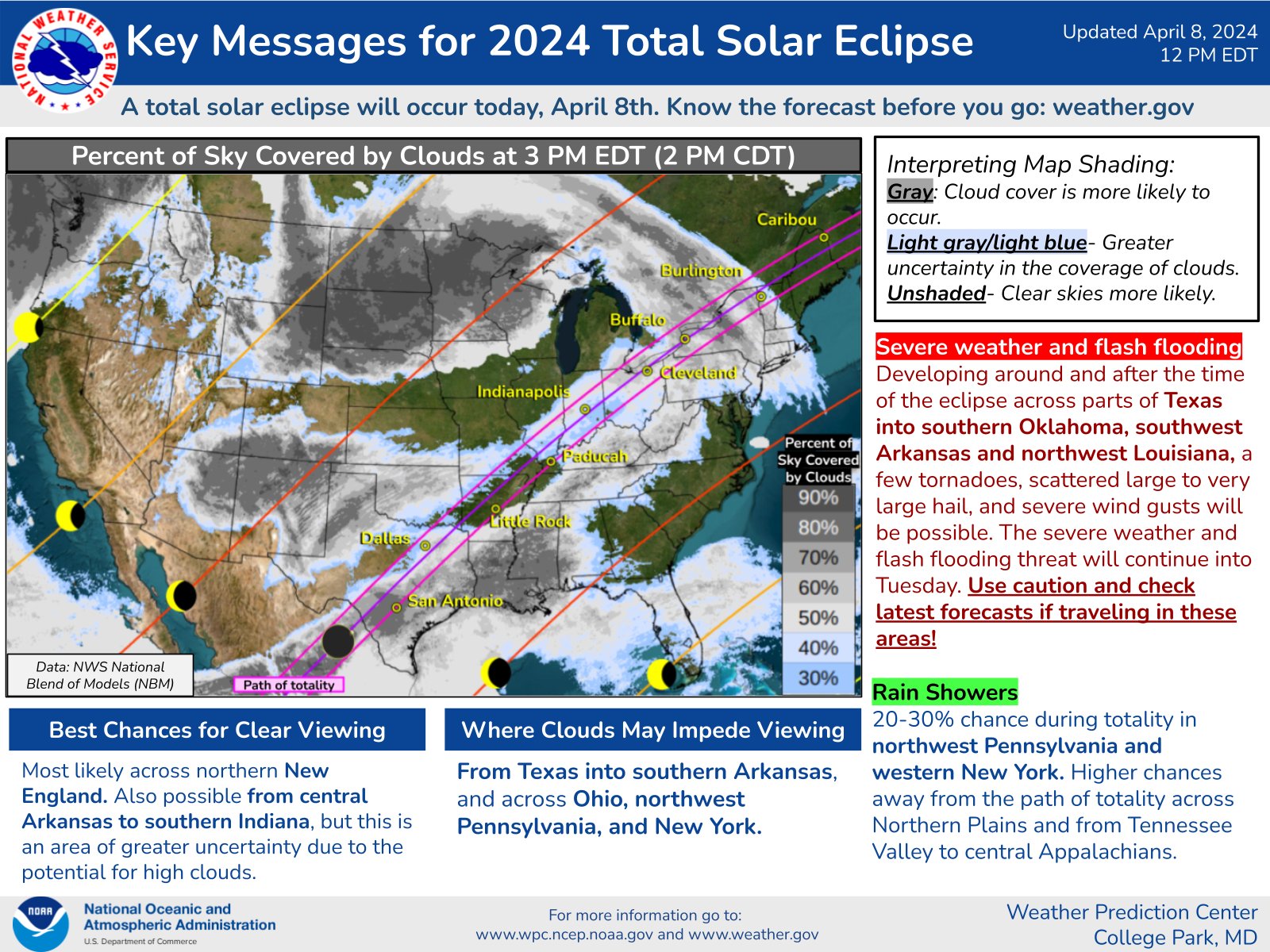
A total solar eclipse will occur Monday, April 8, 2024, stretching from south central Texas through the Ohio Valley and New England. Here is the latest forecast information regarding expected cloud cover, in relationship to the path of totality and partial eclipse.
For the most up-to-date information, see wpc.ncep.noaa.gov
Hazardous Weather Watches, Warnings, & Advisories Briefing Hazards Page View Local Storm Reports Submit Report Road Reports Text Products
Forecasts Fire Weather Briefing Hourly Forecast Graphs Forecast Discussion User-Defined Area Activity Planner Local Forecasts Space Weather Text Products River Graphs Airport Forecasts Snow and Ice Probabilities Winter Storm Severity Index (WSSI)
Current Conditions Observations Radar Satellite Rivers and Lakes River Graphs Road Reports Drought Monitor Text Products Sunrise/Sunset Tables Seasons (Equinoxes/Solstices)
Past Weather Climate Maps Climate Normals/Averages Climate Records Climate/Almanac Data Climate Graphs Past Events Observation History Climate Summaries Text Products Sunrise/Sunset Tables
Preparedness Weather-Ready Nation Storm Spotters/Skywarn Safety & Preparedness Weather Radio StormReady Awareness Weeks
About Us Glossary Tours Social Media Contact Information Organization Office History
US Dept of Commerce National Oceanic and Atmospheric Administration National Weather Service Quad Cities, IA/IL 9040 N Harrison Street Davenport Municipal Airport Davenport, IA 52806-7326 563-386-3976 Comments? Questions? Please Contact Us.
IMAGES
COMMENTS
We would like to show you a description here but the site won't allow us.
Reports regarding traffic incidents, winter road conditions, traffic cameras, active and planned construction, etc.
Statewide - The Colorado Department of Transportation launched a new, easy-to-use COtrip.org website on Sept. 29 that features a new 511 map that will allow drivers to safely navigate Colorado roads. While motorists have been using COtrip.org for nearly two decades, this updated website will offer new features that will help travelers plan their route ahead of time, and be prepared for road or ...
Track the weather and extreme weather situations along your route to make every trip a safe journey, whether it's sunny, rainy, or snowing.
Travelers are urged to "know before you go." Gather information about weather forecasts and anticipated travel impacts and current road conditions prior to hitting the road. CDOT resources include: Road conditions and travel information: COtrip.org; Download the COtrip Planner app: bit.ly/COtripapp
The free COtrip Planner app, which launched Oct. 1 in the Apple and Android app stores, adapts the same road-condition and closure information that CDOT long has provided via its COtrip.org ...
The COtrip app is the Colorado Department of Transportation's (CDOT) official real-time traffic and traveler information app. The COtrip app provides statewide travel information for Colorado's interstates, U.S. routes and state highways. ... - Winter weather conditions (seasonal) - Plow tracker - Hands-free, eyes-free feature to announce ...
Travel Resources. Learn about CDOT services and tools available to ease your transportation needs. View Programs, Maps & Tools.
You can watch it on FOX31 NOW in the player above. Original Story: Winter weather is right around the corner and that means it will soon be time to start tracking winter weather road conditions ...
The COtrip app is the Colorado Department of Transportation's (CDOT) official real-time traffic and traveler information app. The COtrip app provides statewide travel information for Colorado's interstates, U.S. routes and state highways. It does not include information for county roads or city streets. Please Note: Continued use of GPS ...
CoTrip.org offers real-time updates on road conditions and closures, a searchable map, a trip planner tool, camera images, live streaming video and more. COTRIP.ORG. CDOT APP. Download the CoTrip Planner App from the Google Play or Apple App stores today. CDOT's Call 511 from any phone
The free COtrip Planner app, which launched Oct. 1 in the Apple and Android app stores, adapts the same road-condition and closure information that CDOT long has provided via its COtrip.org website. The website also has a more user-friendly refresh, and both integrate Google's recognizable mapping interface as their backbones, with CDOT live ...
Driving in Colorado can be dangerous, especially in bad weather. It's best to check the weather and view webcams of any passes that your route includes before heading out. Being prepared and planning your Colorado road trip is your best path to success. View up-to-date travel alerts. cDOT webcams list Eisenhower Tunnel Webcam - I-70
40°. Interstate 70 reopens as winter weather moves through Colorado. Watch on. Some of Denver's unhoused community brave winter storm in tiny homes. 1/108. Watch on. Latest Denver metro area ...
By CDOT | For the Trail-Gazette. October 4, 2021 at 6:46 a.m. The Colorado Department of Transportation launched a new, easy-to-use COtrip.org website on Sept. 29 that features a new 511 map that ...
37°. Radar. Past. 10:45 PM PDT. Climate change causing heat waves to last longer, study says. 1/200. Watch on. Latest road closures in Denver, Colorado, according to CDOT travel information on ...
Road closures closed latest Independence Pass Denver Colorado CDOT travel trip road traffic conditions accident alert snow slicky icy wet snow roads, radar map.
US 50 MP 158.05 EB : 0.8 miles E of N Main St/CO 135 in Gunnison: Looking at Roadway. US 50 MP 165.60 WB at CO 114 LiveView: Looking at Road Surface. US 50 MP 165.60 WB at CO 114 LiveView: Looking East. US 50 MP 165.60 WB at CO 114 LiveView: Looking South. US 50 MP 165.60 WB at CO 114 LiveView: Looking West.
US 550 Red Mountain Pass opened at 12:15 p.m., Thursday, Feb. 8. February 8, 2024 - Southwestern Colorado - Winter driving impacts expected through Sunday morning on many southwest mountain passes. Low visibility and increased avalanche danger prompts US 550 Red Mountain Pass to remain closed tonight.
The Colorado Department of Transportation provides COtrip, a map that tracks accidents, road conditions, chain and traction laws and other important road information.
NOAA's National Weather Service launched a new website today: The National Water Prediction Service. This new hub for water data, products and services combines local and regional forecasts with water data and new national level capabilities, such as flood inundation maps and the National Water Model. "This online water hub is
Flags blow in the wind at the Washington Monument earlier this month. (Brian Paeth/Flickr) * Wind advisory until 6 p.m. for most of the area * A somewhat subjective rating of the day's weather ...
Updated: Friday, April 12, 9 a.m. ET: Sunny and dry conditions are forecast throughout the day with a high temperature in the low 70s. Breezy conditions this morning, turning windy by midday with ...
Masters weather forecast: Saturday at Augusta. Saturday's weather forecast is projected to be sunny with a high of 76 degrees, according to AccuWeather. The site says it will be "a great day for ...
54°. Radar. Past. 10:25 PM PDT. Climate change causing heat waves to last longer, study says. 1/200. Watch on. Latest road closures in Denver, Colorado, according to CDOT travel information on ...
Welcome to the Daily Weather Update from FOX Weather. It's Saturday, April 13, 2024, and National Scrabble Day. "SQUEEZE" some orange juice, flip a few "FLAPJACKS" and hit shuffle on your phone's "JUKEBOX" while you start your day here with everything you need to know about today's weather… and net 79 bonus Scrabble points in the process.
When weather conditions warrant, CDOT will activate the Traction Law. If weather conditions deteriorate, CDOT will activate Chain Laws for passenger and commercial vehicles. Motorists will be alerted to an active Traction or Chain Law by highway signage, COtrip.org and traffic/roadway condition alerts.
- Articles from The Weather Channel | weather.com
A later statement said that the first round will begin at 10:30 a.m. ET with patron gates opening at 9:30 a.m. ET. . CNN Weather anticipates that the forecast in Augusta is set to improve later in ...
A total solar eclipse will occur Monday, April 8, 2024, stretching from south central Texas through the Ohio Valley and New England. Here is the latest forecast information regarding expected cloud cover, in relationship to the path of totality and partial eclipse.