

The GW Hatchet

Are you human? Yes!
Email address:
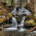
TRAiLS seeks permanent adviser after staff turnover, decline in programming

Officials seek to hire an adviser for an outdoor adventure student organization that has reduced its excursions to account for shuffles in its University points of contact throughout the year.
Since the organization’s last full-time adviser left in fall 2021, leaders of GW TRAiLS have cut the number of the group’s annual trips from 60 to 70 per semester to 40 while cycling through five different interim advisers, which members said haven’t had the necessary time or experience to help direct TRAiLS’ operations. Leaders of TRAiLS said the group needs a full-time adviser with expertise in outdoor education who can also serve as an on-call University liaison during the group’s regular overnight trips to meet student demand for weekly outdoor excursions.
Officials posted a job listing for a senior outdoor education coordinator in the Lerner Health and Wellness Center on Thursday, a position that would advise TRAiLS, according to the job description. The student organization’s leaders said they have encouraged officials to hire a new adviser since the beginning of the academic year because it would alleviate some pressure from guides — student volunteers that lead other students in hiking and backpacking trips over weekends and school breaks — and help bring back the organization’s typical operating capacity.
“We just need someone who is prepared fully to take on TRAiLS as part of their responsibilities,” TRAiLS’ President Liz Hartmetz said.
Hartmetz said the group — which has more than 1,000 members on Engage and operates multiple outdoor trips each weekend — needs an adviser who can devote a minimum of 20 hours a week to the group. She said the group’s last designated adviser handled the administrative responsibilities of organizing and booking transportation for weekly trips, including overnight stays, and coordinating with third-party outfitters for TRAiLS.
“It’s a very overwhelming job,” Hartmetz said. “I think the University is getting to that point where they’re understanding the breadth of what we do, because it’s easy to be like ‘Oh, this is like a student organization.'”
She said while TRAiLS’ recent advisers have worked to support the group, they haven’t had the time to take on the breadth of the work that the organization requires, which has pushed administrative tasks onto students.
“That just led to more of a shift in responsibility toward the leadership team, especially the interns, myself and the rest of leadership,” Hartmetz said.
University spokesperson Julia Metjian said TRAiLS operates within “University lines on risk management” and that the University approves all of TRAiLS’ activities for safety. She said the University provides guides with first-aid supplies, information about medical facilities nearest to the hiking trails and trains guides “extensively” in emergency safety procedures like Wilderness First Aid and CPR.
Metjian declined to comment on why TRAiLS has undergone five adviser changes since fall 2021.
“It is crucial that every member participating in TRAiLS feels fully supported and safe at any location,” Metjian said in an email.
Senior Laurel Brodsky, a guide for TRAiLS, said the organization lost touch with the University after the last permanent adviser left and GW transitioned the group from the Office of Student Life to the Office of Campus Recreation in spring 2022. She said the interim advisers that the University assigned after the adviser’s departure had other responsibilities on top of TRAiLS while the last permanent adviser was primarily dedicated to the student organization.
“If someone had a concern, they were available to the broader guide community to reach out to for developing new ideas,” Brodsky said. “They were really there and accessible. Now, under Campus Recreation, we do a lot more of that internally because we don’t have that support from the University.”
She said the last permanent adviser would attend weekly guide meetings and received a Wilderness First Responder Certification — which allows people to make critical medical and evacuation decisions while in remote locations — to answer safety questions about potential new trips that guides wanted to put on.
“It’s a little frustrating that we’ve kind of lost this broad network of support,” Brodsky said.
Senior Leo Kehagias, a guide, the former president of TRAiLS and a Hatchet reporter, said since the departure of the last permanent adviser, the interim University liaisons have done their best to support the group, but TRAiLS is an organization that demands full-time attention that their recent advisers have not been able to accommodate with their busy schedules and other commitments.
“They had a lot of other things on their plate, right? A lot of other assignments and we were kind of just shuffled in as an extra responsibility for them,” Kehagias said.
Kehagias said TRAiLS guides are held to the same standards as University staff during trips, although they aren’t paid. He said it is unfair that unpaid guides must take on the responsibilities previously held by their adviser, like finding and booking trips. He said TRAiLS has two administrative student interns, hired and paid by the University to assist TRAiLS’ adviser, who have also picked up more logistical responsibilities since the last permanent adviser left.
“Since the guides aren’t paid, I think that you need to have somebody who you know that is their job from the University,” Kehagias said.
He said TRAiLS needs an adviser who prioritizes the work that the student organization requires in order for the group to flourish on campus.
“TRAiLS is an essential organization to helping maintain good wellness and mental health despite being stuck in the city,” Kehagias said. “So it’s essential that the organization continue as a service for GW students.”

Please see this website on a larger screen.
This version of the website is not responsive yet and cannot be seen on screens smaller than 1240px wide. Please open it on a laptop, or enlarge or browser window to see it. Thanks!
- George Washington’s 1753 Journey

- The French and Indian War

- Braddock Trail
- Forbes’ Trail

- Documentary (The War That Made America)
- Webinar / Summit Recordings
- Phineus Cobb, Embedded Journalist - coming soon!

- Educational Resources
- Plan your Visit
- Upcoming Events
- Past Events
- Newsletters
- News Articles
- About the Trail
- Donate / Sponsors
Washington's Trail
Braddock's road, forbes' trail, scroll to top, george washington travels nemacolin’s path from present-day cumberland, md to the forks of the ohio. the path, as it continues north, becomes known as washington’s trail..
When George Washington first entered the Ohio River Valley in 1753 he was only 21 years old. Recently commissioned as a major in the Virginia Regiment, he came to the region to deliver a diplomatic note to the French at Fort LeBoeuf (present-day Waterford, Pennsylvania) ordering them to withdraw from lands claimed by the King of England and the colony of Virginia. Needless to say, the French commander did not feel “obliged to obey” Washington’s summons to depart and the young Virginian headed home to prepare for war. On his return trip, Washington got his first taste of gunfire when an Indian guide, who was aligned with the French, turned and fired at him from point-blank range. Fortunately, for the sake of America, the bullet missed.
Washington came back to the forests of Pennsylvania the following spring, again following Nemacolin’s Path. He tasted short-lived victory at Jumonville Glen and bitter defeat at Fort Necessity. In the aftermath of the Fort Necessity defeat, Virginia’s governor, Robert Dinwiddie, decided to reorganize his battered regiment into ten independent companies, with no officer holding a rank higher than captain. This meant that Colonel Washington would have to face demotion. Rather than accept such humiliation, the young Virginian resigned from the army. For a short period of time, it seemed as if Washington would never again don a military uniform.

Washington joins Braddock – Nemacolin Path becomes known as Braddock’s Road.
Then, in the spring of 1755, General Edward Braddock came to America to push the French from the Ohio Country and back to Canada. Eager for redemption and “to attain a small degree of knowledge in the Military Art,” Washington offered his services to the general. Braddock replied that he would “be very glad” to take on the young Virginian as an aide. This led Washington back to the frontier and his next brush with death at the Battle of the Monongahela.
By all accounts, Washington’s behavior at the horrifying debacle was exemplary. According to one account, the fearless officer rode into the thick of the battle and attempted to rally the Virginia troops who were being shot down not only by the enemy, but from the frightened Redcoats who fired wildly at anything that moved. Sensing that the soldiers were in an exposed position, Washington rode forward and cried out to his men, “Boys! Take to the trees!” Braddock, who was riding nearby took the command as an act of cowardice instead of common sense. He lifted his saber and bellowed out, “I’ve a mind to run you through the body. We’ll sup today in Fort Duquesne or else in Hell!” After the general was severely wounded, it was Washington who organized the retreat and saved the remnants of Braddock’s shattered command. Just before he died, General Braddock was heard to mutter the prophetic words, “We shall know better how to deal with them [the enemy] another time.”
After Braddock’s defeat at the Monongahela, the British army went into winter quarters and the provinces were forced to fend for themselves against the sporadic raids launched against the frontier by the French and Indians. Restored to rank, Washington spent the next three years struggling to defend the backcountry. Plagued by a lack of supplies with his command threatened by desertion and insubordination, the young warrior bitterly complained, “I have been posted… for twenty months past upon our cold and Barren Frontiers, to perform I think I may say imposibilitys that is, to protect from the cruel Incursions of a Crafty Savage Enemy a line of Inhabitants of more than 350 Miles in extent with a force inadequate to the taske.” Despite such hardships, Washington held on until the spring of 1758, when General John Forbes and his army finally brought a promise of redemption.

Washington joins General Forbes and a new road is cut.
In 1758 the French held control of Fort Duquesne and the Forks of the Ohio. General Forbes’ route from Philadelphia to the Forks of the Ohio to seize control from the French required cutting a path to build a road over mountains and through over 300 miles of wilderness. Meanwhile, Colonel George Washington and his troops from Maryland and Virginia traveled Braddock’s Road from the Potomac and planned to meet Forbes’ army in Cumberland, MD to reach the Forks. But Forbes was intent on the more direct route so he pushed forward, cutting a new road over the mountains.
Washington and his troops had no choice but to join with Forbes as they advanced over Laurel Ridge to arrive at Loyalhanna Creek.
Your browser is not supported for this experience. We recommend using Chrome, Firefox, Edge, or Safari.
George Washington Trail
Follow along the George Washington Trail 1753 through Allegany County, the Mountain Side of Maryland, commemorating young Washington's first diplomatic mission to western Pennsylvania - a mission that led to the outbreak of the French and Indian War.
About The George Washington Trail 1753
Throughout Allegany County, going west from Oldtown, Maryland, to the crest of Savage Mountain, George Washington’s familiar profile is depicted on blue signs along our scenic byways and city streets. Serving as a marker for George Washington’s first diplomatic venture to what is now western Pennsylvania through Allegany County in 1753, the signs encourage visitors to travel along the route to discover George Washington's first diplomatic mission to demand French troops leave land (now western Pennsylvania) claimed by England. Follow Washington's profile though Allegany County to discover the footsteps of the Father of our Country and learn more about his military career that began and ended in our mountains.
Washington's 1753 Misson
In 1753, the imperial nations of France and Great Britain and the Native American nations all claimed control of the Ohio Country, the area encompassing present day western Pennsylvania and eastern Ohio. Acting on orders from Virginia Governor Robert Dinwiddie, 21-year-old Major George Washington embarked upon a dangerous expedition north from Williamsburg to deliver a diplomatic message to the French ordering them to evacuate the region. The French erected three forts to reinforce their claim to the area: Fort Presque Isle (Erie, PA), Fort sur la Riviére aux Boeufs (Waterford, PA) and Fort Machault (Franklin, PA). During his journey to the French forts in the winter of 1753-1754, young Washington encountered many hazards. There were “excessive rains and vast quantity of snow”. He was nearly shot by a Native American guide near Harmony, PA, and he nearly drowned in the icy waters of the Allegheny River near present day Pittsburgh, PA. When Washington returned to Williamsburg in January of 1754, he reported to the governor that the French intended to remain entrenched in the Ohio Country. This marked the beginning of the military struggle known as the French and Indian War.
Along the George Washington Trail 1753
Relive Washington’s first diplomatic expedition—retrace the steps of our first president, take advantage of the historic and natural attractions along the way. Round, blue trailblazer signs with Washington's famous profile are located along Washington’s route through scenic western Maryland and Pennsylvania. Explore these three locations as you travel Maryland's portion of the George Washington Trail 1753 to gain a historical perspective on Washington’s various other visits to Allegany County in 1748, 1753, 1755-58, and one last time as President in 1794. Pick up the trail at the Maryland/PA border and follow it north for the Pennsylvania portion of the Washington Trail 1753 .
Points of Interest Along the Trail
The michael cresap house - oldtown, md.

On this spot in 1748, Washington arrived as a teenage surveyor and enjoyed the hospitality of famous colonial frontiersman, Thomas Cresap. Young Washington saw his first Native American around Cresap’s campfire. This historic home and Thomas Cresap’s grave remain here to help visitors share the wonder of this river crossing.
PROSPECT SQUARE - CUMBERLAND, MD
On this spot in 1755, Washington served as an aide to British General Edward Braddock at Fort Cumberland during the French and Indian War. Later, in 1794, he returned to the same parade grounds to review troops preparing for the Whiskey Rebellion, a protest against the first tax imposed on a domestic product by the newly formed federal government. You can feel the history in your bones touring parts of the original Fort Cumberland in the basement of Emmanuel Episcopal Church on Washington Street and Washington’s log headquarters, twice occupied by George Washington in his travels to Allegany County, located at Riverside Park in Cumberland, Maryland.
Braddock’s Road At St. John’s Rock - Frostburg, MD
Deep in the Savage River State Forest, a once-in-a-lifetime sight awaits experienced hikers. The longest stretch of Nemacolin’s Trail on public land winds west toward Fort Duquesne from the rocky precipice where Washington crossed with over 2,000 elite British troops on Braddock’s ill-fated 1755 march.
This project was funded in part by Preservation Maryland and the Maryland Historical Trust. The trail links to a greater trail system that travels from our stopping point at the Maryland/Pennsylvania border through Pennsylvania's modern highways to explore Washington's route through Pennsylvania on the same 1753 military expedition to Pittsburgh.
More to Consider
History & museums.
Allegany County, Maryland, boasts three centuries of American history. The heyday of…
There's nothing more exhilarating than hitting the open road to discover pieces…
Places To Stay
A memorable getaway starts with a great place to lay your head at night, and Allegany…
Eat & Drink
You have heard the saying, 'the way to one's heart is through their…
CURRENT PRICES END MAY 12
Outside Festival feat. Thundercat and Fleet Foxes.
FROM JUST $44

The 5 Best National Park Road Trips in the U.S.
From western landscapes to the Blue Ridge Parkway, our national park expert maps out five beautiful road trips—all doable in a week

Heading out the door? Read this article on the Outside app available now on iOS devices for members! >","name":"in-content-cta","type":"link"}}'>Download the app .
Here’s the dream: Quit your job and hit all 64 national parks in one huge multi-month road trip where you live mostly in a van and finally see all of these iconic landscapes for yourself. To call that dream unrealistic is an understatement, at least for me, for a variety of reasons (see “quit job,” above), though it’s been accomplished by an Outside writer.
The closest I’ve ever come was in my 20s, spending a month driving around the Rocky Mountains and American Southwest in my VW Jetta during summer break from graduate school. A decade or so later, I re-created that trip with my wife and our then four-year-old twins. Both experiences were awesome. One of them had more tantrums.
You can plan a great park trip that captures the open-road spirit on a smaller scale. Below, I’ve outlined five itineraries that take in multiple parks, all within a week. I picked a variety of terrain—lonely desert basins, ice-cold swimming holes, perfect hikes, and cultural wonders. There are one or two classic routes.
But mostly, I chose these because they go to parks that don’t get the massive amount of attention some of their cousins receive. So gas or charge up and go.
1. Blue Ridge Parkway, from Shenandoah to Great Smoky Mountains
Virginia/north carolina, distance: 470 miles, duration: four-plus days.

This trip is in my backyard, so I’m biased, but it’s also awesome, because the entire 470-plus-mile route is within a national-park unit. The Blue Ridge Parkway stretches for 469 miles along the peaks and valleys of the Southern Appalachian mountain range, connecting two of the country’s most-visited national parks, Great Smoky Mountains in North Carolina/Tennessee and Shenandoah in Virginia.

Driving the entire length of the parkway is slow (speed limit is between 25 and 45 miles per hour) and full of curves in the road, and also overlooks, side hikes to swimming holes, and mountain hikes through a lush landscape with elevations that top 6,000 feet. And that’s just the road between the two great national parks.

Heading south on the parkway, you will find picnic areas, trailheads, and scenic views. Give yourself at least a couple of days to complete the road alone, making sure to hike the three-mile out-and-back Sharp Top Trail in the Peaks of Otter area near Bedford, Virginia, which leads to a panoramic view of the Shenandoah Valley and the Allegheny Mountains. When you get to North Carolina, hit Grandfather Mountain State Park, where you can climb the 7.6-mile out-and-back Profile Trail , scrambling along outcroppings and climbing ladders to the summit of the 5,964-foot Callaway Peak.

Adventures in Shenandoah: Located just 70 miles west of Washington, D.C, Shenandoah National Park is home to 200,000 acres of 4,000-foot peaks, dense hardwood forest, waterfalls, and historic farmland. The most popular hike is also one of the park’s toughest; Old Rag Circuit is a 9.2-mile loop that requires rock scrambling with some use of your hands to reach Old Rag Mountain, which offers 360-degree views of the park and surrounding farmland. You need a permit to hike the mountain between March 1 and November 30. It’s only $2, but permits are limited to 800 a day, so get them up to 30 days in advance .

If you’re looking to cool off, hike the Whiteoak Canyon/Cedar Run Circuit , an 8.1-mile loop that gains 3,000 feet while traversing two tight gorges packed with waterfalls and swimming holes. Lower and Upper Whiteoak Canyon Falls are the highlights, as Upper Falls drops 86 feet between narrow canyon walls, and Lower Falls has a primo plunge pool.
Adventures in Great Smoky Mountains : The Smokies comprise a mix of rocky streams stacked with waterfalls and swimming holes, and steep slopes thick with vegetation. It’s hard to get across just how green this park is. On the northern end, you’ll find Midnight Hole, a deep, cold swimming hole at the base of a small waterfall. The pool is lined with 15-foot boulders, and locals like to jump from them into the deep part. Access is via the easy three-mile out-and-back Big Creek Trail . If you want to ditch the crowds (GSMNP gets 14 million visitors a year), hike deeper into the park. Ramsey Cascades Trail is an eight-mile round trip through stands of old-growth tulip poplars to the 100-foot Ramsey Cascade, the tallest waterfall inside the park.
A few historic fire lookout towers still stand inside the park, but the most scenic is Mount Cammerer, a circular wooden building perched on a rocky outcropping, nearly 5,000 feet in elevation, offering views of 5,000- and 6,000-foot peaks as well as the Pigeon River Gorge. Hike this 11.6-mile out and back from Big Creek Parking Area, and you will do a piece of the Appalachian Trail, enjoying scenic stretches along Big Creek before climbing to the ridgeline.

Stay : In Shenandoah, Big Meadows is a historic stone-and-chestnut lodge in the middle of the park. Choose from lodge rooms or rustic cabins (from $251 a night ), and wander the mile to Big Meadow after dark for stargazing . Lodges and campgrounds are spaced all along the 469-mile Blue Ridge Parkway, so it’s easy to break the journey up into chunks if you’re not in a hurry. Julian Price Campground is one of the most popular overnights ($20 per night, reserve six months in advance). The 190-site facility sits next to Julian Price Lake, where you can rent canoes . Under Canvas has a glamping resort on 182 acres of hardwood forest near the Gatlinburg entrance of Great Smoky Mountains National Park. Each fully furnished safari-style tent has a private bathroom, and the place features live music, campfires at night, and yoga in the morning, not to mention an on-site restaurant with seasonal dishes and craft beer.
2. Joshua Tree to Death Valley, California
Distance: 250 miles, duration: at least three days.

This route will take you to an underappreciated gem.
Is it weird to spend several days in Southern California and not go to the beach? Well, this desert romp is packed with so much wild terrain you won’t miss the Pacific Ocean. Joshua Tree National Park is 800,000 acres of sandstone boulders, crusty desert floor, and stands of the eponymous trees, while 250 miles north, Death Valley is the largest national park in the lower 48, at 3.5 million acres. Inside are 14,000-foot peaks, expansive craters, dunes, and slot canyons.

Weather is a factor with this itinerary because both parks are in the desert and hot as hell in the middle of summer (temps can reach 120 degrees). So consider this a late-spring or early-fall trip. (If you ever go in summer, do all of your adventures at dawn, take a ton of water, and be back at your place or camp before lunch. Also tell someone exactly where you are going.)
The 250-mile drive is mostly two-lane highway that offers a mix of desolate beauty (you’ll drive between Leghorn Lakes Wilderness and Sheephole Valley Wilderness) and California weirdness (the World’s Largest Thermometer is on this route). Want more adventure? As you drive between these two standout parks, try a pitstop at Mojave National Preserve, which has the largest grove of Joshua Trees in the world, natural springs, and towering dunes.
You can fly into Las Vegas or Los Angeles. L.A. to Joshua Tree is about 150 miles and not terribly interesting, so let’s just go straight to the park.

Adventures in Joshua Tree : J-Tree is a bucket-list rock-climbing destination, but the hiking is easily as good, and just being in the place is amazing. The 2.5-mile Split Rock Trail gives hikers a chance to see and scramble on some of the park’s signature boulders, including Split Rock, a 20-foot-tall formation with a fissure in the middle, and to explore a few small caves. If you want to see a lot of Joshua Trees (who doesn’t?), hike the Panorama Loop in Black Rock Canyon, a 6.5-mile lollipop that traverses one of the densest groves of Joshua Trees in the park, or sections of ridgeline trail, with long-range views of the 11,000-foot peaks inside the nearby Sand to Snow National Monument .

Adventures in Mojave National Preserve: Just 70 miles north of Joshua Tree, Mojave NP offers a convenient diversion on your way to Death Valley. Stretch your legs by hiking the three-mile out-and-back trail into Kelso Dunes , a 45-square-mile field with mounds of sand that rise 650 feet from the valley floor. The Kelso Dunes actually produce “booming,” which is a deep, rumbling vibration that you can hear and feel from the crest of one. Be aware that hiking in dunes is tough, as the sand shifts below your feet with every step.

Adventures in Death Valley : You hiked dunes in Mojave, so in Death Valley National Park, let’s focus on the canyons and peaks. Fall Canyon is a six-mile out and back through a slot canyon so narrow that at points you can touch both sides from the middle.

If it’s your first time to the park, you’re obligated to visit Badwater Salt Flats, the lowest and hottest point in the U.S. There’s no designated trail through the flats, so wander at will through the flat, crispy valley, flanked by the Panamint Mountains and Black Mountains.

Stay: The Inn at Death Valley is a historic lodge located inside the park, with five-star accommodations. Consider this an oasis in the desert, complete with a spring-fed swimming pool (from $359 a night). At Joshua Tree, try to reserve a spot at Indian Cove Campground , which has sites tucked between massive boulders. There are no hookups, but RVs are allowed ($25 a night). If you can’t score an advance reservation there, Hidden Valley Campground has first come/first serve sites ($15 a night). Also, Field Station is opening a new location outside of Joshua Tree in May, with campsites for van-lifers and private rooms, all of which have access to the property’s gear shop, coffee shop and communal spaces (rooms from $127 a night).
3. White Sands National Park, Carlsbad Caverns, and Guadalupe Mountains National Park
New mexico and texas, distance: 300 miles, duration: four to five days.

Want variety? This trip has a trio of national parks that are close geographically, but a world apart in terms of terrain. Carlsbad Caverns National Park is all about the subterranean, protecting 119 caves, the biggest of which are open to exploration. Guadalupe Mountains National Park covers a swath of 8,000-foot peaks in West Texas, and those include eight of the 10 tallest in the entire state. White Sand Dunes National Park is home to a 275-square-mile gypsum dune field that rolls towards the horizon in a series of white tidal waves.

All three parks are within a couple hundred miles of each other, and El Paso serves as an ideal starting point to fly into the area and rent a car. These parks don’t see the crowds that some of the big-ticket units draw in summer, so there’s a better chance for quiet and good campsites. The three also have totally different climates. White Sand Dunes is hot (but not like J-Tree or Death Valley), Carlsbad is underground, and Guadalupe is chilly.
Other than a brief period where you skirt around the edge of El Paso, you’re driving mostly two-lane highways with a real “middle of nowhere” vibe between the parks. Think sand and scrub brush for as far as the eye can see.
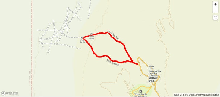
Adventures in White Sand Dunes: Alkali Flat Trail is a five-mile loop through the heart of the sand dunes, following red trail markers. You’re climbing and descending 60-foot dunes the entire time, so pace yourself and expect your legs to be worked at the end. Bring a sled (sold at the visitors’ center if you don’t have your own), as you’re allowed to slide down the steepest slopes along the route.
Adventures in Guadalupe Mountains National Park : The signature adventure is hiking the 8,751-foot Guadalupe Peak , with a craggy, treeless summit, the tallest in the state of Texas. The views stretching east over the plains are endless, but to earn them you will climb 3,000 feet in just over four miles. Bring a jacket, as the summit is notoriously windy. But the real treat of Guadalupe Mountains is Devil’s Hall Trail , a four-mile out-and-back that’s rocky with mandatory scrambling to traverse a dry river wash. Towards the end, you’ll climb Hiker’s Staircase, an easy hand-over-hand natural rock ladder out of the wash and into a narrow slot canyon.

Adventures in Carlsbad Caverns : Start with a self-guided tour of the Big Room, the largest single-cave chamber in the U.S., loaded with bizarre stalactites and stalagmites. An elevator could deliver you into the cave, but instead walk the switchbacks down via the Natural Entrance, and feel what it’s like to go from the surface into the cold, dark underground. The full hike down the Natural Entrance and into the Big Room is 2.5 miles and should take a few hours; without the walk in, the hike is 1.25 miles, with a .6-mile shortcut also possible, and parts of the Big Room are wheelchair accessible . If you want something spicier, sign up for a ranger-led tour of Lower Cave , which requires descending 60 feet of ladders and ropes to a series of smaller rooms with crazy rock features, like the skinny, tall “Texas Toothpick” or “cave pearls,” which look like clusters of eggs ($20, reservations required).

Where to Stay: Guadalupe Mountains National Park and Carlsbad Caverns are close enough that one campground works as a base camp to explore both. Check out Pine Springs Campground in Guadalupe Mountains, which has 20 tent sites and 13 RV sites you can reserve in advance ($20 a night). A number of hiking trails (including Devil’s Hall) begin here. The closest campground to White Sands is in Oliver Lee Memorial State Park, which has private desert sites ($10 per night). The backcountry campsites in White Sands are closed indefinitely, but nearby Alamogordo has a variety of chain hotels.
4. Denali National Park to Kenai Fjords National Park
Distance: 400 miles, duration: five-plus days, but if you’re flying all the way to alaska, take your time.

Alaska is an awe-inspiring collection of giant mountains, permanent ice fields, and jagged coast, and Denali and Kenai Fjords national parks encapsulate choice slices of that unique topography. Denali National Park covers more than 6 million acres of Alaska’s interior, including the 20,310-foot Denali, but also the tundra and spruce forest that surround it and attract big-time wildlife like caribou and brown bears. Kenai Fjords National Park couldn’t be more different; instead of forest and towering peaks, it’s home to 600,000 acres of glaciers, inlets, bays, and islands. More than half of the park is covered in snow and ice year round, and the majority is accessed by water. While much of Alaska isn’t conducive to road trips because of a lack of roads, these two parks are less than 400 miles apart and connected by highways.

The two-lane blacktop between the main destinations rolls out like a highlight reel of Alaska, offering views of Denali’s snow-capped peaks at one point and the Cook Inlet at another. Keep an eye out for Beluga whales, which live and breed in the inlet. Chugach State Park , with its 3,000-foot mountains, is also on the route.
A visitor can fly into Anchorage, halfway between the two parks. You’ll basically have to ditch the car at each destination, as car travel is limited in both parks. There are few roads in Kenai, and the main road through Denali is limited to shuttle traffic to minimize impact on the landscape. But that’s part of the charm here.

Adventures in Denali: Denali isn’t a “drive through” park. In fact, private vehicles aren’t allowed past mile 15 of the scenic Denali Park Road, though bikes get the green light. To ride in, start at the Savage River Visitor Center (mile 15) and bike to Sable Pass between miles 37 and 42, where the final 1,500-foot climb to the pass is rewarded by views that stretch all the way to Denali itself. But Sable Pass is best known for its wildlife. Mostly treeless and full of berry bushes, it attracts brown bears, caribou, and Dall sheep, which often graze in the tundra near the road. From the top of the pass, you can turn around and bike back, or, if you pre-arrange it, hop on the free Savage River Shuttle , which has bike racks. Bike Denali offers rentals (starting at $75 per day).
Or consider a guided rafting trip on the Nenana River, a glacier-fed stream that forms the eastern border of Denali. Book a mild or wild day trip with Denali Raft Adventures . The 11-mile canyon run is packed with class IV rapids with names like “Coffee Grinder,” and the full ride, for ages 12 and up, is a brisk two hours. A different short option, the two-hour-long Wilderness Run, is ideal for young families, as it contains mostly class I-II rapids and offers a good chance to see wildlife like moose and caribou. (From $130 a person, May through September).
Adventures in Kenai: Kenai is a coastal park with most of its goods accessed via boat, but land lovers have options, too. Hike on the edge of the Harding Ice Field , the largest permanent ice field in the U.S., stretching for 700 square miles and feeding Exit Glacier, which forms a half-mile-wide river of ice that melts into Exit Creek. Start at the Exit Glacier Nature Center and hike the 8.2-mile out-and-back Harding Icefield Trail , which climbs a total of 3,000 feet through the surrounding forest to gigantic views of the icefield. If you really want to throw yourself into the landscape, book an intro-to-ice climbing trip with Exit Glacier Guides , exploring crevasses and climbing pitches of vertical ice with use of rope, crampons, and axes ($249 per person).

For a water-borne adventure, head to Bear Glacier Lagoon, 12 miles south of Seward, where a thin beach separates a glacier-fed lake from the Gulf of Alaska. The lake sits in a deep bowl rising to green ridges, and the water is littered with house-sized icebergs. Liquid Adventures offers fully outfitted day trips to the lagoon ($550 per person).

Where to Stay : In Denali, book a spot at Savage River Campground , which has 32 sites tucked into a spruce forest ($49 a night). Located on mile 13 on the Denali Park Road, it’s easy to reach with a car (some campgrounds in Denali are only accessible by shuttle bus), but the real prize is access to Savage River and incredible views of Denali via a short gravel-road walk. Reservations are recommended, but not required. In Kenai, Exit Glacier Campground has 12 walk-in tent sites, first-come, first-served. They’re free, but fill up most nights during July and August. The Seward Adventure Lodge , in the middle of downtown Seward, is a seven-room mid-century-era motel with renovated rooms located just minutes from the edge of Kenai ($190 per night, two night minimum).
5. Mesa Verde and Black Canyon of the Gunnison National Parks
Distance: 160 miles, duration: three days.

Rocky Mountain National Park gets most of the love in Colorado, and while it’s incredible, the Centennial State has other unforgettable national-park units. Mesa Verde National Park and the Black Canyon of the Gunnison National Park are nestled into the southwest corner of the state, proximal enough to make for an ideal weekend road trip. Mesa Verde is a cultural treasure, containing more than 5,000 archaeological sites, including the early cliff dwellings of the Ancestral Pueblo people.

The Black Canyon of the Gunnison is altogether different, enveloping a nearly 2,500-foot-deep gorge surrounding the Gunnison River. It’s a deep, dark chasm with sheer vertical walls, rugged hiking and climbing, boating, and world-class trout fishing.

You can fly into Durango to kick the trip off, and Telluride is smack dab in the middle of the route between parks if you want to throw in a visit to a classic mountain town. The Jud Weibe Trail , a locals’ favorite and handy but fantastic afternoon outing, offers views of the ski area and entire valley on varied and forested terrain.
The majority of this road trip cruises through San Juan National Forest on a highway with views of some of Colorado’s tallest and most iconic peaks, including the 14,158-foot Mount Sneffels and 14,023-foot Wilson Peak. You’ll pass right through Telluride, but you can also make a 22-mile roundtrip detour to Ouray to soak in the hot springs.

Adventures in Mesa Verde: Get your bearings by driving the six-mile Mesa Top Loop Road, which winds along past excavated mesa-top villages, with overlooks to see cliff dwellings, including the Cliff Palace, which archaeologists believe could house up to 100 people. There are 30 miles of hiking trails inside the park, so you can see a lot of the area in a day. If you’re limited on time, hike the 2.4-mile Petroglyph Point Trail , which will have you squeezing through boulder passages and traversing cliffside singletrack to a large petroglyph panel. To see the cliff dwellings up close, reserve a spot on a ranger-led Cliff Dwelling Tour ($8 per person, reservations possible 14 days in advance). The Balcony House Tour is the most adventurous: you ascend a cliff face into the 700-year-old dwelling via a series of ladders, then worm through a narrow tunnel that connects rooms.

Adventures in the Black Canyon of the Gunnison : The BCOG is a tough canyon to navigate, as there are no bridges connecting the North Rim and South Rim, so it’s a circuitous two-hour drive between the two sides of the park. The South Rim is the more developed, with a dozen overlooks, a visitors’ center, and an 88-site campground. The North Rim is more primitive, with a gravel road providing access to a few developed trails and a handful of overlooks. Both sides are stunning, but I’m pointing you to the South Rim for its hiking and scrambling routes. If you want to stretch your legs and enjoy the view, stroll the two-mile Rim Rock Nature Trail for shots of the canyon and river below. But you’re here for the scramble to the bottom of the gorge via the unmarked Tomichi Route , which drops 1,960 feet in just one mile (the park allows use of the trail and offers a video about it). There’s a lot of down climbing and loose rock, but at the bottom you’ll have the Gunnison River all to yourself. Bring a fly rod; the Gunnison is a gold-medal trout stream. This is a full-day adventure, and you’ll need a permit (free) to descend into the canyon. Get one at the South Rim Visitor Center.

Where to Stay : Both parks have large campgrounds, if you want to keep it simple and budget friendly. The Black Canyon of the Gunnison’s South Rim Campground is convenient (only a mile from the visitors’ center), but don’t expect a ton of privacy ($20 a night, reservations recommended). The North Rim has a smaller campground , with 13 sites separated by piñon and juniper trees ($20 a night, first-come, first-served). Morefield Campground , in Mesa Verde, is large, with 267 sites within a broad, grassy canyon ($38 a night, reserve in advance).
If you want to spend a night in Telluride, check out The Bivvi , an upscale hostel with private or shared rooms that caters to road trippers (from $40 per night).
Graham Averill is Outside magazine’s national parks columnist. He’s currently trying to convince his 15-year-old twins to re-create the national parks road trip they undertook a decade ago. It’s not going well.

For more by this writer:
The 9 Most Fun Adventure Lodges in North America
The 9 Best Gateway Towns to U.S. National Parks
The 8 Most Adventurous States in America. Number 1 Is …
11 Remote Destinations That Are Definitely Worth the Effort to Visit
- Denali National Park and Preserve
- Fly Fishing
- Joshua Tree National Park
Popular on Outside Online

Enjoy coverage of racing, history, food, culture, travel, and tech with access to unlimited digital content from Outside Network's iconic brands.
Healthy Living
- Clean Eating
- Vegetarian Times
- Yoga Journal
- Fly Fishing Film Tour
- National Park Trips
- Warren Miller
- Fastest Known Time
- Trail Runner
- Women's Running
- Bicycle Retailer & Industry News
- FinisherPix
- Outside Events Cycling Series
- Outside Shop
© 2024 Outside Interactive, Inc
IMAGES
VIDEO
COMMENTS
Black Forest Trail Backpacking ($225) Dates: Saturday, March 9 - Wednesday, March 13. Join us as we head to Pennsylvania's Tiadaghton State Forest for a 5 day, 4 night backpacking trip. This trip will entail a 43 mile loop divided into roughly 10 miles per day. We will be splitting into two groups, each comprised of 2 TRAiLS guides and 5 ...
TRAiLS Guide Program Application. The application process for the TRAiLS Guide Program occurs at the beginning of the spring semester for first-year and sophomore undergraduate GW students. No outdoor experience is required, and everyone interested in leading others in the outdoors is encouraged to apply. The 2024 application is now closed.
GW TRAiLS is George Washington University's outdoor adventure and leadership program that is committed to connecting the GW community to the outdoors. Join GW TRAiLS at our bi-weekly general body meetings, on one of our weekend day trips, or on an extended break for a longer immersive outdoor experience! Visit us at https://go.gwu.edu ...
Trails trips will continue to be offered throughout the spring semester for students on-campus and in the local D.C. area. Social distancing and COVID-19 measures are vital to ensure the safety of everyone on Trails trips. Wearing face coverings, keeping six-feet of distance, reducing the number of people travelling to 10 per group, and not ...
In the U.S. and internationally, many organizations aim to encourage trustworthy artificial intelligence systems—iterations of AI that users, developers, and deployers see as accountable, responsible, and unbiased. However, the researchers at TRAILS believe that there is no trust or accountability in AI systems without participation of ...
From hiking to caving - from surfing to kayaking- GW TRAiLS organizes a diverse range of outdoor... Washington D.C., DC 20052
GW Trails, Washington D. C. 1,822 likes · 16 were here. From hiking to caving - from surfing to kayaking- GW TRAiLS organizes a diverse range of outdoor ad
GW Trails is GW's outdoor adventure and leadership program that is committed to connecting the GW community to the outdoors through weekly adventure trips. Student Association The mission of the Student Association is to further the interests and promote the welfare of all students at GW.
2,153 Followers, 545 Following, 225 Posts - See Instagram photos and videos from GW TRAiLS (@gwtrails) 2,153 Followers, 545 Following, 225 Posts - See Instagram photos and videos from GW TRAiLS 🐻🍃 (@gwtrails) ... Your resource for all things outdoors at The George Washington University. linktr.ee/trailsgw. outdoors! fee waivers! merch ...
Campus Recreation. Division for Student Affairs. Lerner Health and Wellness Center. 2301 G Street, NW. Washington, DC 20052. Phone: 202-994-1532. Email: Many GW Students want to stay active while in college, but without the commitment of participation in a varsity sport.
D.C. is located farther away from comparable wilderness areas in the mid-Atlantic, placing more responsibility on GW to help students access out-of-reach outdoor areas. A solution to our current problem is funding outdoor groups like GW TRAiLS, which organizes outdoor trips for students. The prices for these trips range from $20 to $200 ...
In 1753, the imperial nations of France and Great Britain and the Native Americans all claimed control of the Ohio Country, the area encompassing present-day western Pennsylvania and eastern Ohio. Traversing modern highways, this route commemorates young George Washington's first military and diplomatic venture in the fall and winter 1753-1754.
Since the organization's last full-time adviser left in fall 2021, leaders of GW TRAiLS have cut the number of the group's annual trips from 60 to 70 per semester to 40 while cycling through five different interim advisers, which members said haven't had the necessary time or experience to help direct TRAiLS' operations.
Learn about George Washington's 1000-mile round-trip journey from Williamsburg, Virginia, to Fort Leboeuf in Western Pennsylvania. ... The path, as it continues north, becomes known as Washington's Trail. When George Washington first entered the Ohio River Valley in 1753 he was only 21 years old. Recently commissioned as a major in the ...
Outdoor Adventures via GW TRAiLS. GW TRAiLS is an outdoor adventure and leadership program committed to connecting our students to the outdoors. Join GW TRAiLS on one of our upcoming day or weekend trips this fall. Learn more and sign-up for one of our upcoming fall trips. Check back often as we continue to add both day and weekend outdoor ...
Follow George Washington's 1753 Trail through Allegany County to commemorate his first diplomatic mission that marks the French and Indian War prelude. ... Explore these three locations as you travel Maryland's portion of the George Washington Trail 1753 to gain a historical perspective on Washington's various other visits to Allegany County ...
Ramsey Cascades Trail is an eight-mile round trip through stands of old-growth tulip poplars to the 100-foot Ramsey Cascade, the tallest waterfall inside the park.
2 Nights of lodging at Les Suites in the Mont Tremblent pedestrian village. Daily bus transfer to the Ski Resort. Lift tickets to Mont Sainte-Anne, Stoneham, Le Massif, & Mont Tremblent. For more information contact the Campus Recreation office at 202-994-7546 or [email protected]. Register Here.