Countries Explored and Counting!
32 countries.
- Get in touch
- Country Flags
- Terms of use

Add more countries to the list

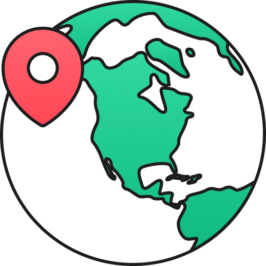
Visited Travel App

Unlike other travel apps, with Visited you can re-live your experiences over and over, uncover new destinations and map your personal travel goals. See why over a million travelers use our app.

MAP YOUR TRAVELS
Design your personal travel map by displaying countries, states / provinces / regions and cities of where you have been or want to visit.
SEE WHERE TO NEXT
Visited has the answer for the burning question that most travelers are asking, “Where to next?” We rank the countries to visit based on the number of experiences, places of interest and inspirational photos you have selected.
See your full travel plan by country with a beautiful gallery of photos—and ability to share it.

TRAVEL EXPERIENCES & BUCKET LIST
Track your experiences by country such as where you’ve gone golfing, snorkelling/diving, skiing, wine tours and others.
Keep up with your travel life goals by selecting all the countries of the world that you want to visit.
Add travel journal notes by country of your travel dates, points of interest or personal memories.
GET INSPIRED
Build your destination wish list by browsing hundreds of photos. Keep track of the places you must visit based on interest. See famous places you have been to.

CUSTOMIZED EXPERIENCE
Share your travel map, stats and bucket list with your family and friends
Adjust the sovereignty for disputed territories
Available in over 30 languages.
You can learn more about us here.
PERSONALIZED TRAVEL STATS
How do you stack up against other world travelers? Share your personalized stats (travel ranking, percentage of the world seen, countries visited) with others.
See the Top 10 visited countries from your country. See your top 5 most frequently visited countries. And more!

PRINT YOUR PERSONALIZED MAP
Create a custom map print of your world travels in less than 10 minutes. Customize it with your own colors and have it delivered straight to your home.
You can learn more about getting your map poster here .
THE KRUGER 100
“Doing Nothing is not an Option”
A donation to the Kruger 100 charity Challenge will help ensure that every endangered species and their habitat are protected. And that we can also get a better understanding of two diseases that need more research. Not just for today, but for tomorrow and for generations to come. Your support will help take action on the ground.


You'll never travel without our trip planner again
Travel planning at its best. build, organize, and map your custom itineraries in a free travel app designed for vacations & road trips, powered by our trip planner ai.

Your itinerary and your map in one view
No more switching between different apps, tabs, and tools to keep track of your travel plans.
What travelers are raving about
Features to replace all your other tools, add places from guides with 1 click, collaborate with friends in real time, import flight and hotel reservations, expense tracking and splitting, checklists for anything, get personalized suggestions, plan like a pro.
Unlock premium features like offline access, unlimited attachments, flight deals, export to Google maps, and much more
Offline access
Unlimited attachments, optimize your route.
4.9 on App Store, 4.7 on Google Play
Discover your next favorite destination
Have tips of your own? Write a guide to share with other travelers like you!
Ready to plan your trip in half the time?
For every kind of trip and every destination, the best road trip planner, the best vacation planner, the best group itinerary planner.
Create Your Free Travel Map
With minimal effort you'll have a beautiful map of your travels to share with friends and family.
Map and visualise your trips. It's fast, simple, fun and free.
Start mapping your trips now!
- Plan your upcoming trips and map previous travels
- Add notes, photos and blog entries to build a rich story of your travels
- Embed your trip map on your own blog
- Save your map as a high resolution image
- Draw custom routes between your trip stops
- Unlimited trips on one map
- Bookmark websites and save them to your trip plan
See how easy it is to make a trip map in this video
Try it yourself!
Create an itinerary map to plan an upcoming trip
Our free travel mapping tool can be a great resource when you are planning your trips. If you are travelling to multiple cities and want to get an idea of which itineraries are going to be the most efficient, just map all your stops out and see what the route looks like. Once you have worked out the route, you can add notes and bookmarks to each stop to keep all your ideas in one place. Also, don't forget to tap into our amazingly helpful community of travellers by asking for trip advice in our forums .
Map out all your old trips
We spent a lot of time making this as easy to use as possible, especially when mapping out lots of stops and lots of trips. You can very quickly add new stops to trips with minimal detail. For example, you can choose to add dates to each stop. Or not. This mapping tool is flexible that way. Mapping out all your travels can be a huge amount of fun, as it's a great way to relive memories.
Add photos to your trips
Travellerspoint allows you to upload as many photos you want. And if you geotag them, you'll find they will automatically link to stops near where the photos were taken.
Embed your map on your blog
If you are just looking for a simple route map to add to a blog post you're creating then this will do that for you nicely. You can either use the standard embed code or customise the map tiles to various other looks as well. A beautiful interactive travel map will ensure your blog entry stands out from the crowd.
Generate stats for all your travels
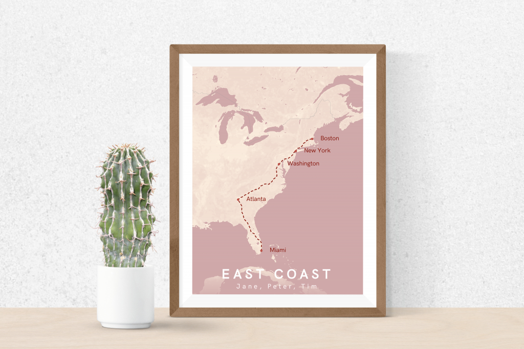
Some map samples.
Would you like to see examples of some trips people have mapped out? Click on any of the maps below to see a fully interactive version.
Questions and Answers
What are some typical users of this mapping platform.
- People wanting to map out an upcoming trip
- People wanting to map out all their previous travels
- Travel agents wanting to create a trip map for their clients
- People wanting to explore different destinations for an upcoming trip
Create your map
What tool do you recommend people use to map out their life's travels?
The Travellerspoint mapping system is the perfect tool for this job. It can map out lots of trips in broad strokes or in great deal.
How many stops can I add to a trip?
There is no limit to the number of stops you can add to your trip map.
Is there a limit to how many trips I can map?
No, you can map all your life's travels on one map. We have members with over a hundred trips mapped!
What mapping platform do you use?
We use Mapbox GL JS which is a competitor to Google Maps. We allow you to choose which map tiles you use with options available from Mapbox.com and Maptiler.com
How can I use the maps I've created on Travellerspoint?
Once you've mapped out your trip, you can embed the map in a blog on Travellerspoint or elsewhere. You can also generate a shareable link that shows the map in a standalone way.
Can I save the map as an image?
Yes, we offer an easy button save the map as a high resolution PNG. Perfect for photobooks or for printing out.
How long has Travellerspoint been around for?
Travellerspoint has been around since 2002. Our mapping tool has evolved over the years from a simple log of countries to the detailed trip mapper it is today.
Where do you get the travel information from that's used in the map?
We have our own member created travel guide. When people view your trip map they will see content from that guide included with the locations.
Can I turn off the guide content that's included?
Yes, if you are a supporting member you can turn off the guide content.
Can I get turn by turn directions from this tool?
No, that's not what our mapping tool is intended for. If you need turn by turn directions, we recommend using something like Google Maps instead.
Can I create custom routes?
Yes, it's possible to create custom routes. This is particularly useful when you are plotting a boat trip that we don't have any routing information for.
Looking for a Step by Step guide?
This How To Create a Map of Your Travels guide will take you through the process of creating your travel map in a series of easy to follow steps.
Need more convincing?
You can do a lot more than just map your travels on Travellerspoint. Creating an account is totally free and gives you acess to other handy features like:
- A blogging platform where you can write about your travels
- An active travel forum to ask for advice from other travellers
- Unlimited photo uploads. We also feature our members' best travel photos
Create your trip map now!
How to Use Google My Maps to Plan a Trip (Ultimate Guide)

Note: Some of the links in this post may be affiliate links. This means if you click on the link and purchase the item, I will receive a commission at no additional cost to you. More details are here .

I love a good map. I’ve got maps hanging on my walls. I go to the bookstore to read maps. Whenever I navigate my way home using only a map, I feel like I must have some innate bushcraft skills. And if you’ve read my posts about traveling in Maine , you’re probably sick of me talking about the DeLorme Atlas by now.
But while reading paper maps will always inspire a sense of get-up-and-go adventure for me, I’m not totally opposed to using tech for planning my trips and navigating on the ground.
And one of my favorite techy solutions? A secret little trip planner called Google My Maps, buried inside of everyone’s favorite map tool.
Google My Maps lets you create shareable custom maps with multiple layers, plus location pins with icons and notes. It’s a great way to brainstorm travel plans or create a trip itinerary from a desktop. And since the map can be viewed in the Google Maps app, you can use it to navigate on the go.
To give you an example of what this post will show you how to do, here’s one of the custom Google Maps I’ve created for a trip.
Keep reading for an overview of how to use Google My Maps to plan a trip, plus a video tutorial of how to set it up—all updated in 2023. I’ll also share answers to commonly asked questions and some lesser known tips to help you get the most out of this tool.
A quick note: Creating a custom map in Google My Maps is distinct from Google Lists of saved places. Check out our Google My Maps vs Lists comparison to see all the differences and our full guide to using Google Maps Lists .
8 Top Google My Maps Features
(AKA Why It’s Awesome)
Google My Maps allows you to see your trip itinerary.
This is so helpful, especially if you’re a visual person or enjoy using maps. But even if you’re not, it’s still really useful to see where everything is in relation to each other as you plan your trip, vacation, or holiday because it helps you be realistic about your plans.
It connects with other Google apps.
Setting aside my (ahem, very rational) fear that they may take over the world soon, I love all things Google. My Maps stores a copy of the map in whatever Google Drive account you’re using. (Am I the only one who has six of these?) So if you like to create Google Docs or folders to store trip planning information, documents, photos, or itineraries, it’s nice to have your map easily accessible in the same folder.
You get additional location information since it’s part of Google Maps.
If a location is on Google, you can see their website, phone number, address, reviews, and website when you add it to your custom map. (Note that you can’t see this information when clicking on your saved pin from the Google Maps app, but you can from desktop.)
You can add your own extra notes and photos.
Customize your map even more by adding notes, photos, or videos. Use the notes during planning to add website, hours, or tips. If I hear about the location from a particular website, I usually add that link and what was noted in the article about the location (e.g., it’s a great sunset spot, which dish on the menu is recommended) so I can reference it later.
You can view your route by creating a layer with directions.
When I traveled to Burlington, Vermont, I wanted to see the length of the bike trail on the map, so I used the directions feature to show the whole route. (Check out the Burlington travel guide for an example of the travel map I created that includes the bike path route.) And while I haven’t done this yet, you could also use Google My Maps to plan a road trip itinerary for a longer adventure.
Caveat: As I’ll discuss later, you can’t use directions layers to get turn-by-turn directions (but I mention an alternative below). For this reason, I only use these layers to visualize my route.
It’s highly customizable.
Don’t mind me while I swoon over the color coding and organization options over here. Use custom icons, layers, and colors so it’s easy to see what things are at a glance. For example, you can give different locations individual styles: a coffee cup icon for cafes, a bed icon for hotels, and a swimming icon for beaches. You can also use layers in many different ways, such as one layer for each day of your trip or one layer for each category (like dining, lodging, and things to do).
In-depth planning on your computer. Easy, on-the-go access from your phone.
While you can’t edit the maps from the Google Maps app on iPhone or Android, you (and anyone you’ve shared them with) can view them. You can click on icons and see your notes, as well as navigate to those locations.
Note that there used to be a dedicated My Maps app on Android, but this has been deprecated.
It’s easy to share it with a friend or with the world.
If you’re planning a trip with other people, it’s easy to share the map with others . And if it’s something you want to make available to everyone (like I do on my travel guide posts), just change the privacy setting and share the link or embed it on a website.
3 Ways to Use Google My Maps
Brainstorm and store ideas for future “maybe” trips.
I often come across a really interesting hotel, restaurant, or fun thing to do in destinations I want to travel to in the future, and I want to make sure I don’t forget about them. I have so many bookmarks in so many places (Pinterest, Facebook, Instagram), but Google My Maps is the place I’ve started storing ideas for future trips.
Plan your trip itinerary.
Want to use Google Maps for route planning? When you’re ready to plan an upcoming trip, plot it out visually by using Google My Maps to create your itinerary. If you like structured itineraries, you can easily create a detailed day-to-day plan.
Or, you can use a looser itinerary structure like we usually do by adding all the places you might like to go.
For example, on a day trip to NYC, we added tons of places to eat on the map (thank you, Tiktok). As we were walking around doing other activities and started to get hungry, we were able to easily see which saved restaurants were closest to us.
Navigate on the go.
Whether you’re using your map loosely for ideas or for a structured itinerary, you can pull it up on your phone anytime and get directions to your next location.
Not sure what you want to do today, or want to see what the closest restaurant from your list is for dinner? Pop into your custom map to jog your memory from the notes you made or to get directions to your next location.
Recommended: Need an organized backpack to take on the road? Check out my favorite luggage for camping, road trips, and flying: the Cotopaxi Nazca 24L and Allpa 35L !
How to Use Google My Maps to Plan a Trip
How to create a new custom map.
Go to Google My Maps from your desktop browser . Check the Google icon in the top right corner to make sure you’re using the Google account you want to. Click “Create A New Map” and a window will open with a blank map. To give your map a name and description , click the map name (“Untitled Map”).

You can also change the color and style of the base map if desired. At the bottom of the layer panel on the left, click the arrow next to “Base Map.” You’ll get a window with nine options, including terrain, light political (a very light version of the standard Google Maps), satellite, and some different colored versions. Note that changing the base map style on desktop won’t change anything when viewing on mobile in Google Maps.
How to Add and Edit Layers
When you create a new map, the first layer will already be created, so you’ll probably want to rename it. To give your first layer a title , click directly on the title name like you did with the map name, or click the 3 dots next to “Untitled Layer” and then click “Rename Layer.” Clicking these 3 dots next to a layer title is also how you can delete a layer if you add one accidentally or change your mind. In this example, I’m changing my first layer to “dining” and will add all restaurants to this layer.
You can use layers any way you want to, or simply stick to one layer if you don’t need multiple. To add new layers , simply click “Add Layer” in the gray section below the map title and description.
To move a pin between layers , click the pin on the layer and hold down the mouse, and then drag it to the desired layer.

How to Add Location Pins
There are various ways to add location pins to a layer. First, make sure the correct layer is chosen by clicking anywhere in the white area on the layer. You’ll see which layer is selected by looking for the blue bar on the left of the layer.
- In the map search bar, type either a place name or an address. Click “Add to Map” to add a pin for this location . This is how I add most pins.
- If you don’t need an exact location or don’t have an address , you can click the pin marker button below the map search bar (“Add Marker”). It will turn your mouse into a T and you can click anywhere on the map to add a blank pin. You’ll immediately be prompted to add the pin title and description.
- If you’re dealing with very remote locations (or you just like geeky map stuff), you can also use latitude and longitude coordinates in the search bar.
To delete a pin , simply click on it and click the trash icon.

A few tips and best practices for adding pins:
- If the place you’re searching for does not have a listing on Google, you’ll have to use an address. One thing to note is that sometimes Google Maps listings aren’t correct or don’t take you to the right place, so you may want to double check the location if you’re not using a street address to add the pin (especially if it’s a small business without a website).
- I have also found that hiking trail heads are frequently on Google Maps, but they’re not always correct in terms of navigating there by car. I usually add them to my map to get a basic idea of where they are while planning, but I use a paper map or atlas to find them while traveling.
How to Customize Location Pins
To change the title and add notes to your listing, click on the pin on the map, and then click the pencil icon (“Edit”).
To change the color and icon of the pin , click the paint bucket icon (from the pin itself or directly in the layer). Click “More Icons” to view all the icon options. You can color code by type of activity, by layer, or any way that makes sense to you.
To add photos or videos to a pin , click on the pin on the map, and then click the camera icon (“Add Image or Video”). This is another way to make your map interactive, especially after you’ve visited a location and want to share it with others.

How to Add A Directions Layer
I find that directions layers are helpful for showing the route of a walking tour, bike path, or road trip you want to take, but I don’t find them useful for directions while traveling since I can simply use the maps app to navigate.
I use directions layers whenever I want to show an entire route on a map , rather than a specific location. Think of this as the 2024 version of mapping out a trip with AAA paper maps and a highlighter (if you’re old enough to remember).
Click the arrow icon underneath the search bar, which will create a new directions layer. On the legend, click “Driving” if you want to change this to walking or biking directions. Add a location name or address to Points A and B in the legend. If you find that the pins are not exactly where they should be, you can drag the points on the map.
Continue adding points by clicking “Add Destination” on the map. You can either type the information into the legend or hover your mouse to a spot on the map and double click it. (This is especially useful if you’re tracing a route on something like a bike path or hiking trail that won’t have an address.)
Rearrange the order by dragging the items around in the legend. Just like altering directions on Google Maps navigation, you can click on part of the route and drag it to a different road if you want to change part of the route after it is complete.
If you need to access the directions so you can see the distance of your route or the time it will take, click the three dots on the layer and click “Step-by-Step Directions.” Note that you can’t actually use this to get turn-by-turn directions in Google Maps.

How to Share A Google My Map
There are several options for sharing your Google Maps trip plan.
Open up your map, then click the share button in the gray bar above your layers. To allow others to view your map (which includes embedding on your website), click “change” under the section “Who has access.” For embedding, you will need to make this setting public.
Otherwise, if you want to allow others to edit your map, add their email address in the “invite people” section.

How to View Your Custom Map in Google Maps (iPhone or Android)
Open Google Maps and go to the Saved icon at the bottom. Scroll to the bottom of this screen and click “Maps.” Choose the My Map you want to view. The layers with your custom icons will now be visible on your Google Map. You can click on any pin to view your details (such as description or photos), as well as to navigate there.
To close a map, click on a pin and then click “View Map Legend.” There, you can click the Close icon.
From the Map Legend, you can also toggle layers on and off, and then backing out to the main map (don’t click Close—just the back arrow or back button).
How to Navigate with a Custom My Map (iPhone or Android)
To navigate to one of your pins, open your map, find the pin for where you want to go, click it, and then click “directions.” When you do this, you won’t see your custom map anymore but will be looking at the regular navigation of Google Maps.
You can’t use a My Maps “directions layer” for navigation. If you’re looking for that functionality, I recommend just creating a route in Google Maps and sending it to your phone (or sharing with others). See here for more details.
How to Import Locations from Google Sheets, CSV, or Excel
Importing locations to a My Maps layer can be helpful in a few scenarios:
- You have a significant amount of locations to add to your layer
- Your data is already in the form of a spreadsheet
- You want additional fields included besides the default Name and Description
- You want to create groupings of pins (for example, a list of 50 restaurants could have a column for “Cuisine,” which will give you the option to group and style the pins by cuisine)
The process is simple, and you can import a variety of file types, including CSV, Excel (XLSX), or directly from Google Sheets. There are also special file formats that import map data from other programs, but this section is focused on spreadsheet-type files that you create and format.
Create a spreadsheet with the desired column headers. At a minimum, you need place names and either addresses or latitude-longitude information .
If you want to group your pins by some type of categorization, you should include that as a column. Other columns you could include: website, phone number, description, or notes. While Google Sheets allows you to include photos in a cell, Google My Maps will not import photos in this way (it will include the column as a field, but will be blank).
Once your spreadsheet file is ready, click “Import” on a blank layer (if your map already has layers, you will need to add a new layer to see this option). If uploading a CSV or XLSX, do this from the Upload tab. If using a Google Sheet, click the Google Drive tab and choose your file.
Choose which column has location data (address or latitude-longitude) and click “Continue.” Choose the location name column next and click “Finish.”
To change the icons individually, click “Uniform Style” next to the paintbrush on your layer. Under “Group Places By,” choose “Individual Styles.”
To change styles by a category column (such as Cuisine), click the link next to the paintbrush and choose to group places by the desired column. You can then give each category its own color or icon.
You can manually add new pins to this layer, and they will include all the fields you imported from the spreadsheet columns.
You can also add more items to your spreadsheet, and import this new data. Click the three dots on your layer. Under “Reimport and Merge,” click “Add More Items” and choose your file. It will add the new rows to your layer.
How to Import a Route from Google Maps Timeline History (KML) or GPS Data From a Fitness App (GPX)
Google My Maps can import routes and locations you’ve already traveled to via special file types that are very easy to download from certain apps. This could be useful if you want to share a walking, biking, or driving route that you’ve taken without having to recreate it on a directions layer.
Note that this only works as well as the GPS satellites were able to track your location while you were traveling.
If there are a lot of clouds, dense forest, buildings, or anything else blocking the GPS signal, your tracked route will be much less precise. I’ve noticed that Google Maps sometimes has my route showing somewhere I couldn’t have walked or driven.
If you have your location history turned on in Google Maps, you can download a KML file from a trip, which will include the route traveled and location pins for any stops. Sometimes it misses a location name or adds a pin in the wrong place, but overall it’s pretty good.
Go to your Google Maps Timeline and locate the day you want to export. Click on it, and you should now see your route highlighted along with any stops you made. Now click the gear icon on the bottom of your map, and click “Export this day to KML.” Go to your My Map and on a new layer, click “Import.” Choose the KML file you just downloaded. You can now edit each portion as needed—changing the color and thickness of the route line, changing the location icons, as well as adjusting the route where desired.
If you have other apps that track your location, such as fitness apps, you may be able to download a GPX file that shows the route you took. The instructions for doing this will vary from app to app, but I was able to easily find it in Samsung Health by looking at the detail of a particular workout/walk and clicking the three dots to download a GPX. The import process to Google My Maps is the same as above.
With both methods, you can make adjustments to points/stops along the way or even add more pins. With the Google Maps KML file, you can also adjust your route by moving the small white dots.
Google My Maps Tutorial
Here’s a walk through video to show you how to use Google Maps to plan a trip, along with several of my own Google My Maps itinerary examples. Coming soon: a 2024 update!
Google My Maps Examples
Here are a few more examples of My Maps I’ve created for sharing recommendations, trip ideas, and actual vacation planning.

Google My Maps FAQs and Tips
As great as Google My Maps is for planning a trip, there are some limitations to using it. Lots of questions have also come up about more specific uses and ways to use its features. Thanks to all the readers who have asked or shared tips in the comments as I’m always looking to make this a more robust guide. I’ve organized the questions and tips here since it makes it easier than scrolling through the comments.
How many layers can you add to a map?
Google My Maps limits you to 10 layers. If you are planning a longer road trip and want to create a layer for each day, this limitation may prove frustrating.
Here are a couple of workaround ideas: You can create 2 maps, and have the entire master route as 1 layer on each (showing the very basic route for all 12 days—say from city to city) as a reference. Then build individual layers for each day. As a second option, you could add multiple days to 1 layer and change the titles to start with the day they correspond to (so it would be “1 – Name of Place” instead of just “Name of Place.”) However, this option may not be ideal since you can’t see the titles until you click when you’re on the phone.
How many location pins can you add to each layer?
You can add up to 2,000 pins per layer, and the entire map cannot exceed 10,000 lines, shapes, or places total. I haven’t tested the limits, and it’s possible adding this amount of items could slow things down. My guess is that most travelers wouldn’t need anything so large, but it is possible according to Google .
Are custom Google My Maps available offline?
No, but keep reading for a workaround and alternative.
One of the biggest complaints about Google My Maps is that you can’t download your custom map and pins to use offline, unlike the rest of Google Maps.
However, I have been able to use it in areas with spotty reception. I pulled the map up when I did have reception, and I left it running in the background. It would stay loaded in the app and I was able to pull it up to look at it later when I was out of reception. I’m not sure I would rely on this as a surefire workaround, but it can work in a pinch.
Another alternative, especially if you’ll be traveling in another country where you’ll be completely offline, is to use Google Maps Lists, which can be edited from desktop or your phone but don’t offer the option for separate layers, unique icons, or adding photos.
Is there an app for Google My Maps?
There is no separate Google My Maps app, but you can view your maps within Google Maps. Just make sure you’re signed into the same account, and all your maps will sync.
(There used to be a dedicated My Maps app on Android, but this was deprecated in 2021.)
Can you create or edit maps from your phone?
No, the maps cannot be edited from the Google Maps app. Google My Maps can only be created or edited from the desktop version of the site. This is another huge advantage Google Lists has over Google My Maps because Lists allow you to add new places or entire lists from any device—iPhone, Android, tablet, laptop, or desktop.
Is there a bridge height filter?
No. For RVers and others who need to plan ahead for height limitations, there is no bridge height filter available in Google Maps. Since I haven’t had to use this feature myself, I am not confident in an alternative to recommend. However, from a bit of digging around, there are some apps and GPS units for truckers that may be a good place to start looking if you have an oversize vehicle.
What is the difference between Google Maps Lists and Google My Maps?
They both allow you to create custom maps with pins, but there are some key differences, such as offline access, layer capabilities, customizable pins, and creating/editing within the app. Check out the details on how Google My Maps compares to Lists (including a features comparison table).
How many stops can you add on a directions layer?
You can only add 10 stops per directions layer. This is also the maximum number of stops you can add for navigation in Google Maps. As some readers have pointed out, this can be limiting when you want to use this feature for a long road trip.
Can you use the directions layers on your phone for navigation purposes?
No, you cannot create a directions layer and then access those turn-by-turn directions for navigation in the Google Maps app.
So…are directions layers totally useless? What’s the point of having a Driving Directions layer in My Maps?
Personally, I still like to use these layers, but only to show a route for my very visual brain, rather than to actually create custom directions.
Can you send a custom created route (layer) to someone else so that the other person will take that specific driving route on google maps?
No, you can’t do this from My Maps, but there’s a workaround I can suggest.
Forget My Maps, and use Google Maps from desktop or mobile to plot a route. You can add up to 10 stops, and then you will be able to share your custom directions.
From desktop, there’s an extra step in first sending the directions to your phone. If you’ve created the directions in the mobile app or once you have them pulled up there, you can share them with anyone by clicking the 3 dots next to your list of locations (sharing must be done before clicking “Start”—if you’re already in the navigation, you need to back out of it to share). When you share, it will list all the steps as well as send a link for the other person to open the directions in Google Maps directly.
An important caveat to sharing custom routes: Google Maps will reroute the directions as it normally does according to current traffic at the time of driving, so this method cannot be relied upon if you’ve mapped a specific route for bridge clearances. As a workaround, you can add “stops” on the desired interstate (zoom in and add this literally on the road itself so navigation doesn’t try to take you off an exit), which will force Google Maps to take the driver that way. This is what I do when driving south from Connecticut to PA because Google Maps always wants me to take its beloved George Washington Bridge and I always don’t want to. I add a stop to force my route across the Tappan Zee Bridge. However, I’m not sure I would rely on this workaround as a sole method for RVs or truckers.
Can you see how much time the directions will take?
Yes, on desktop you can view the details if you want to know the distance or how long a route will take. To view distance and time for a directions layer, click the 3 dots on the laye, then click Step-by-Step Directions.
Of course, this doesn’t really help when you want to get this information on your phone or use the directions for navigation. As mentioned elsewhere, the “directions” layer functions best as a way to visualize a route. If you need turn-by-turn directions, see the steps mentioned above to save and send directions in Google Maps.
This post was originally published on July 27, 2017 and has been updated in May 2023.

Travel Photographer | FAA Certified Drone Pilot
Naomi is the coffee-loving, crazy-about-Latin-America writer and photographer behind everything here. She's guided by curiosity and a belief that every place has a story to tell–whether it’s through the intricate details of nature, history that has shaped a culture, or the people who call a place home. Learn More
Map My Travels
Create an Interactive Travel Map of Your Tours and Activities
Are you dreaming of creating your own interactive travel map to bring your tours and adventures to life? With Map My Travels, it's easy! Craft and share custom maps of your travels, embedding them seamlessly on your website. Start mapping your journeys and share them with the world today!
Creating a travel map has never been easier
Combine an intuitive travel map creator with many customization options like uploading your own marker icons as well as loading in GPS files. Creating an interactive travel map has never been easier.
Create custom markers
One of the key features of Map My Travels is to customize the way you want to show waypoints on your travel map. That's why you can add markers to your map in multiple ways:

Add content to your travel map
A map marker without information is not a good marker! People want to know what happened at that specific place. That's why you can easily add a popup to your markers and routes, where you can add the following pieces of content:
Fill your travel map with content!

Embed the travel map on your own website
You can share your map in many different ways. You can share a link to the map on social media or where ever you like. You can also embed the map on your own website, like I've done on my personal website! It doesn't matter if your website is made with Wordpress, Squarespace or any other.

Upload GPS files
Upload your recorded travel data with ease. In the Map My Travels editor you can upload GPS files in the following formats:
After you've added the GPS files you can still change the line's appearance, like color, thickness, opacity etc.

Import your Strava Activities
If you host your travel activities on Strava, a popular fitness app on which you can share your traveled routes (usually used by hikers or cyclists), you can import these directly into the map creator!

If you don't have any recorded route data like from Strava or a GPS file, you can still add lines to your map by just drawing on the map!

Change the look of your travel map
You can customize the look of your map with 4 different map types that Google Maps provides:

Create as many travel maps as you want!
You can add as many travel maps in your account as you want, completely free! There are only limits on the amount of markers and routes you can add to your maps. But you can get started for absolutely free. See more information on pricing and limits on the pricing page.

Create travel maps on any device
All of the map creator features are totally compatible with both laptops and phones. Out of personal experience, I'd recommend editing the maps on a laptop or computer. The experience is a bit better for panning around the map, but it's totally possible to do it on a phone as well. Your travel map will look beautiful either way!

Built by TravelingTice
Hi! I built this application myself as I have both a passion for coding and travel! I've cycled through 13 countries in Europe as well as part of Taiwan!
Brands creating travel maps with Map My Travels


- Push Pin Travel Maps
- Standard Round Pins
- Specialty Pins
- Travel Decor
- U.S. States
- Bucket List Trackers
- Luggage Tags
- Passport Covers / Wallets
- Shipping & Policies
- Canvas Personalization Info.
- Gift Certificates
Your Cart is Empty
- $0.00 USD Subtotal

- Paper Push Pin Travel Maps
- ∙ World Maps
- ∙ State Maps
- ∙ Other Countries/Regions
- ∙ Sports/Hobby Maps
- ∙ Golf Maps
- Framed Canvas Push Pin Travel Maps
- ∙ Canvas Posters Only - Multiple Sizes
- Gallery Wrapped Canvas
- Large 3 Panel Canvas Maps
- Canvas Posters Only - Multiple Sizes
- ∙ Bucket List Trackers
- ∙ Family Map Art
- ∙ Custom Family Sign Art
- ∙ Cork Memory Boards
- ∙ Travel Wall Art
- Travel Gear
- ∙ Luggage Tags
- ∙ Passport Covers / Wallets
- Speciality Pins
- Family Map Art

- Custom Family Sign Wall Art

- Personalized Bucket List Trackers

- Memory Boards

- Travel Wall Art

What Can We Help You Find?

Best Sellers

Let our customers speak for us!
I ordered a custom map for my wife’s Valentine’s Day gift. It was perfect with great communication during the ordering and creating process. It was shipped quickly and arrived with no problems. 100% would recommend.
Our family is so excited to fill this map with pins and use it to plan our future adventures together. Highly recommend the canvas wraparound map!
I am ecstatic about my purchase! Overwhelmingly impressed with the quality of the frame and map. So much detail in the map. I am ordering a world map next. I've received so many compliments and it's inspiring me to travel even MORE.
I was pretty surprised by how great the quality is!!! The free engraving was a perfect personal touch. The frame is beautiful! Overall 10/10. I don’t think I could have found a better map/combo. Super fast shipping too. My husband loved it. Thank you
Everything came as ordered. The map and pins work very well together. Couldn’t be happier.
You will not go wrong with the quality of this product! It is the perfect addition to any room….and since I customized it - it will move with us always. My kids look forward to coming “home” to add a new pin to the map!
We have looked around for so long for something like this to document our travels and decided to try this one…WE LOVE IT! The map is beautiful and the frame we picked looks great on our wall. We can’t wait to add the pins to it so we can remember all our fun trips.
Extremely pleased with the Vibrant Violet Watercolour World Travel Map. Top quality. Well packaged to prevent damage in transit (international shipment), thank you!
Excellent! Well done!
I purchased this for my son's 33rd birthday, and he absolutely loves it! I was so impressed with the service, it arrived in eight days and it is beautiful. It is a great gift, very unique. Thank you for such a nice product and fantastic service!
Our boys love the push pin maps! They have a ton of detail and are very high quality for the price. I've ordered 3 maps so far and plan to get more for others as gifts. Push Pin Travel Maps was excellent with their service, and the products were all delivered quickly and in great shape. I would highly recommend these maps.
We cannot say enough good things!! The Map is absolutely beautiful. Customer service was excellent. Requested a proof of the personalization, it was sent quickly. Map was delivered in a few days after confirming details. Packaging ensured that it arrived in perfect condition. Would definitely recommend and purchase from again.
Fabulous quality! So much nicer than expected.
The colors are very beautiful and quality is really good as well.
I order this as a gift for my niece, who loves traveling as much as I do. She is just 9 yrs. old, but she was extremely excited when she got it. Is a perfect addition to her play/study room, and also motivates her to read, learn, and plan her dream travels with her family to other countries.
I purchased a customized USA VFR push pin pilot's map with my boyfriend's name on it as a gift. Despite a slight delay of about a week due to the holidays, the wait was entirely justified once we received the map. We opted for the canvas poster version, and we were thoroughly impressed with its quality. I highly recommend this product! My boyfriend was absolutely delighted with his gift.
- Australia/Oceania
North/Central America
South america/caribbean, travel map generator - world.

Select Colors and Countries
- N. America/Caribbean
- Central/S. America
Visited: My Travel Map & Lists 4+
Track places been & plan trip, arriving in high heels, designed for ipad.
- #173 in Travel
- 4.5 • 5.4K Ratings
- Offers In-App Purchases
Screenshots
Description.
Beat your own travel stats. Get inspired to visit exotic new destinations. Track your experiences around the world as you tick off your bucket list. MAP YOUR TRAVELS -Design your personal travel map by displaying countries, states / provinces / regions and cities of where you have been or want to visit. TRAVEL ITINERARY - Wondering where to travel next? We got you covered. Select different destinations and places based on travel lists, experiences and inspirational photos. We'll show you which countries have the highest numbers of places you wish to visit. So you can go down the list and optimize your travel plans. - Picking your next travel destination just got a lot easier with the Visited App! GET INSPIRED -Visualize your future travels by swiping through beautiful photos and adding them to your wishlist. TRAVEL BUCKET LIST -Keep up with your travel life goals by selecting all the countries of the world that you want to visit. -Add travel journal notes by country of your travel dates, points of interest or personal memories. KEEP TRACK OF YOUR TRAVEL JOURNEY -Share your personalized stats with others! You can share your travel ranking, percentage of the world seen and countries you’ve visited. -See your top 5 most frequently visited countries. -Create regional maps for over 20 countries, including United States, Canada, Australia, Germany, UK, Russia, France and others. TRAVEL EXPERIENCES -Want to see how many of the worlds’ capital cities you have been to? Or how about how many art museums you’ve visited? Using the list feature, check off places you have been to or want to visit by category. Travel Lists include: African Safaris, Capitals of the World, Wonders of the World, Pyramids, Culinary Experiences, Ancient Sites, Churches, Greek & Roman Ruins, Cruise Ports, Beer Destinations, Palaces, Ski Slops, World's Top Beaches, Shopping Destinations, LGBTQ+ Destinations, Popular Hiking Trails, Lakes, Bridges, Snorkelling/Diving Locations, Chocolate Destinations, Castles, Wine Regions, Kids Attractions, Temples, Mountain Ranges, Rock Climbing Locations, Monasteries, Opera Houses, Funicular Railways, Waterfalls, Volcanos, Mosques, US National Monuments, Hot Springs, Tunnels, Dance Shows, Deserts, Famous Prisons, Canal Cruises, Formula One Circuits, Top Surf Spots, Underground Cities, Whale Watching Spots, Synagogues, Caves, US National Historic Site, Tennis Destinations, Film Festivals, UK National Parks and Scotch Distillery Regions. -Track your experiences by country such as where you’ve gone golfing, snorkelling/diving, skiing, wine tours and others. FULLY CUSTOMIZABLE -Select different colors or design your own based on your travel type -Pick fully accessible, high contrast colors for your map. -Dark mode is supported to make the app easier to use while taking a red eye flight -Adjust the sovereignty for disputed territories SEE HOW YOU COMPARE TO OTHER TRAVELLERS: - Compare your travel stats with other global travellers or friends - See the top 10 most popular countries to visit from your home city - Share your travel map, stats and bucket list with your family and friends Have you ever had a problem where you can’t actually remember all the countries you’ve been to? That’s why we created Visited – a simple and fun travel tracker. With Visited, you will be able to not only keep a log of all the countries, regions, and cities you’ve been to, but you’ll also be able to see your accomplishments beautifully rendered on a world map that you can share proudly. A digital scratch map if you will! You can also use Visited to plan your upcoming adventures by being inspired by breathtaking travel photos and building up your bucket list.
Version 4.2.4
- Adding New Video - Adding New Lists
Ratings and Reviews
5.4K Ratings
Nayan's traveling updates
This is a review about how good visited is. It is an excellent app for people who like to go on holidays to different countries. You can record where you've and record the countries you want to visit. There is a key on the bottom left hand side. That shows you which colours match what, like orange for where you live, purple for the countries you want to go to and green for the countries you have visited. I rate this an excellent app. Although an app called been is slightly better but this is an excellent app
Developer Response ,
Thank you for your review! We have added even more features to the app, especially stats in the latest version. Do let us know if you have any ideas on how to make the app even better!
A little bit broken
The app concept itself is great. I love how you can zoom into countries to get the regions and zoom out and it marks the whole county as visited. It does however seem to glitch when you zoom some countries with regions turning the screen white. This is more prominent when you zoom into a country with regions which border a country which hasn’t yet had regions added and makes it very hard to read and see what you are marking. Having the regions labelled wouldn’t hurt? The other issue I have had with the app is when I tried to use the app without internet connection it signed me out and completely reset the app which is mildly frustrating. When I signed back in with the same email address it had stayed completely empty meaning I had lost all my progress and had to start again. Overall just a few bugs but I’m sure once these have been ironed out the app will be great!
Thank you for your suggestions, we have fixed all issues mentioned in the new version of the app. Regions are now found under each country, to get there click on the country and 'ABOUT' to view it. We have also added cities and other cool features.
Ideas for the app
I have recently downloaded the app and really love it to bits. I hope it continues development into the future but some ideas for a future update are to add more states and regions to some countries like Switzerland with its cantons etc and Belgium, Netherlands, Poland etc with there states. I don’t mind which countries get regions/states etc but there are a few ideas there. But I know that I don’t know what making an app is like but personally I would love to get more states etc to be added in a future update as it allows you to go more in depth with where you’ve been. Keep up the good work.
Thank you for your review and feedback. We have added regions and cities to the map, so now you can mark them off! Thank you so much for making the app that much better!
App Privacy
The developer, Arriving In High Heels , indicated that the app’s privacy practices may include handling of data as described below. For more information, see the developer’s privacy policy .
Data Linked to You
The following data may be collected and linked to your identity:
- Contact Info
- Identifiers
Data Not Linked to You
The following data may be collected but it is not linked to your identity:
- Diagnostics
Privacy practices may vary based on, for example, the features you use or your age. Learn More
Information
English, Catalan, Croatian, Czech, Danish, Dutch, Finnish, French, German, Greek, Hungarian, Indonesian, Italian, Japanese, Korean, Malay, Norwegian Bokmål, Polish, Portuguese, Romanian, Russian, Serbian, Simplified Chinese, Slovak, Spanish, Swedish, Thai, Traditional Chinese, Turkish, Ukrainian, Vietnamese
- Visited Pro £12.99
- Unlock Cities £7.99
- Unlock Regions £3.99
- Remove Ads £3.99
- More Inspirations £3.99
- Unlock Itineraries £7.99
- Developer Website
- App Support
- Privacy Policy

Get all of your passes, tickets, cards, and more in one place.
More by this developer.
UnDebt - Payoff your debt Calc
The Fertility App – IVF & IUI
XWalk: Nordic Walk Tracker
You Might Also Like
Pin Traveler: Trip Tracker Map
Places Been - Travel Tracker
Skratch - Where I've been
Mark O'Travel: Your Travel Log
Countries Been
been: track visited countries
My itinerary
This is a free demo version of our mapping software.
Create an account to save your current itinerary and get access to all our features.
Otherwise your data will be automatically deleted after one week.
- CREATE POSTER
No products in the cart.
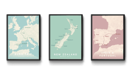
Create your own travel map 🗺
The perfect memory for your holiday, road trip or honeymoon., map your travels.
Use our travel map maker to create your own poster. Simply add your locations and some details and you’re good to go!
Pick your style
Choose from one of our three styles and transform your travels into a piece of art. Prices starting from €4.95. Want to know more? Check our FAQ
Travel Map Inspiration
Get inspired by the maps of our happy customers..
Our customers have created travel maps for their epic road trips, romantic honeymoons or for their exciting adventures. It’s the perfect gift. Where have you been?!
This is just a handful of the maps that our customers have created. They have created travel maps of Australia, USA Roadtrips, backpacking through South-East Asia and many more.
What our customers say
Such a nice idea! I love my personalised map. Very easy to put together and good quality print. Thanks!
We love road trips with our small caravan. Everytime we do a trip now, we print a poster and frame it. Really makes the memories come alive!
Our latest news, stories from customer and more.
Import your travel route (.gpx) automatically
Starting today, you can automatically import your travel routes by importing a .gpx file. In [...]
Metador Network Compared to MyHolidayMap.com
Last week we stumbled upon Metador Network a website with similar functionalities as another tool, [...]
The aesthetic alternative to travelmap.net
The aesthetic alternative to travelmap.net Some of our friends have used travelmap.net to document their [...]
The print-friendly alternative to mytravelmap.xyz
The print friendly alternative to mytravelmap.xyz We love our physical scratch map card and mytravelmap.xyz [...]
A better way to create your own travel map
Over the last few months, we’ve received great feedback on our travel map creator. Travellers [...]

🗺Roadtrip USA: A map of our West Coast adventure
🗺 Roadtrip USA: A map of our West Coast adventure Last week we’ve shown your [...]

Europe Travel Map: an awesome road trip
Europe Travel Map: an awesome road trip Europe is amazing for a long road adventure! [...]

How to create your travel map: a few options
How to create your travel map: a few options. You can create your own travel [...]
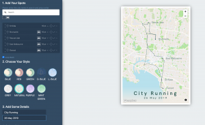
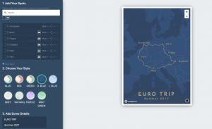
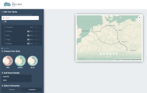
CREATE YOUR OWN TRAVEL MAP
Add your itenary .
You can start creating your map by adding destinations. Start typing in the input box and your destination will come up automatically. Once it appears, click on it to add it to your canvas. Don’t forget to select your travel mode!

Optimise your map
Once you’ve added all your destinations, you might want to optimise your design a bit. You can increase (+) or decrease (-) the fontsize, change the positioning of the labels (Right, Bottom, Left, Top) or remove a location
Pick your map style
Pick the style that you want to use for your travel map. We currently have 3 styles available: red, green and blue. Are you missing a certain style of do you have an idea for a new style? Don’t hesitate to send us a message!
- Search for:
Username or email address *
Password *
Remember me Log in
Lost your password?
Account Options
888-821-0151
$10 off framed maps over $100 with code 10FORTRAVEL
Travel maps to last a lifetime
Personalize your map and then pin your travels! These maps are the perfect gift for anyone who loves or is inspired by travel.
Spread the joy of travel
There is so much delight and anticipation in filling a map with travel memories. Personalized maps make meaningful, long-lasting gifts!
Give a gift that keeps your traveler inspired!
A push pin map lets them track their travels, recall past adventures and plan new ones!
Testimonials
Beautiful my husband and i are so excited to track our adventures with this lovely map. fast shipping and in perfect condition., breathtaking in person my husband and i first saw this in a home of an airbnb host and knew we had to have it it's absolutely perfect and a great conversation piece. each pin marks a precious memory. perfect for travelers, adventurers and perpetual wanderers., i bought this as an anniversary gift. it came beautifully framed with a nice, engraved personalization plate. even nicer than i had hoped. my husband loved it and it will make a pretty addition to our wall — not to mention a cool way to capture travels and travel plans., bestsellers.

Map Your Travels Push Pin World Travel Map Framed
from $ 169.00

Personalized World Traveler Push Pin Map

Urban Slate World Travel Map

Contemporary World Travel Map
from $ 99.00

Give a gift with a personalized touch!
We individually print each plaque, so your message will be uniquely yours! Whether the map is a gift or for your own family, make the personalization as special as the recipient.
Customers trust us
We have been selling our heirloom-quality maps for over 20 years to thousands of happy customers! Our mission is to provide quality craftsmanship, outstanding customer service, and exceptional maps made in the USA!
The National Parks Collection
Celebrate the national parks with coasters, prints, maps and posters
Modern Traveler Maps
Featuring modern graphic design — these maps are the latest in our Traveler Map Series
- Bucket List Maps
From the sports lover to the outdoor enthusiast — track all of your adventures with a Bucket List Map!
How a Map is Made
Our maps have been seen on:
Regular price $ 179.00
Unit price / per
only -228 left in stock
Email Sign Up
Sign up for special promotions available only to our email subscribers!
Celebrating 20 Years!
Thank you for supporting our family-owned small business. We couldn't have done it without you!
- Travel Maps
- Scratch Maps
- Travel Decor
- Global Gifts for Good
Shopping Cart
Your cart is currently empty..

Moscow Metro Map

This re-design of the Moscow metro map focuses on the clarity of the information and the personality of the city.
Creative fields.

Information Architecture
- information design
- Moscow metro
Attribution, No Derivatives
THE 10 CLOSEST Hotels to Statue of Lenin, Elektrostal
Hotels near statue of lenin, property types, distance from, traveler rating, hotel class.
- Best Value Properties ranked using exclusive Tripadvisor data, including traveler ratings, confirmed availability from our partners, prices, booking popularity and location, as well as personal user preferences and recently viewed hotels.
- Traveler Ranked Highest rated hotels on Tripadvisor, based on traveler reviews.
- Distance from Statue of Lenin See properties located closest to the place of interest first with confirmed availability for your dates from our partners.
- Articles >
The Moscow Metro Museum of Art: 10 Must-See Stations
There are few times one can claim having been on the subway all afternoon and loving it, but the Moscow Metro provides just that opportunity. While many cities boast famous public transport systems—New York’s subway, London’s underground, San Salvador’s chicken buses—few warrant hours of exploration. Moscow is different: Take one ride on the Metro, and you’ll find out that this network of railways can be so much more than point A to B drudgery.
The Metro began operating in 1935 with just thirteen stations, covering less than seven miles, but it has since grown into the world’s third busiest transit system ( Tokyo is first ), spanning about 200 miles and offering over 180 stops along the way. The construction of the Metro began under Joseph Stalin’s command, and being one of the USSR’s most ambitious building projects, the iron-fisted leader instructed designers to create a place full of svet (radiance) and svetloe budushchee (a radiant future), a palace for the people and a tribute to the Mother nation.
Consequently, the Metro is among the most memorable attractions in Moscow. The stations provide a unique collection of public art, comparable to anything the city’s galleries have to offer and providing a sense of the Soviet era, which is absent from the State National History Museum. Even better, touring the Metro delivers palpable, experiential moments, which many of us don’t get standing in front of painting or a case of coins.
Though tours are available , discovering the Moscow Metro on your own provides a much more comprehensive, truer experience, something much less sterile than following a guide. What better place is there to see the “real” Moscow than on mass transit: A few hours will expose you to characters and caricatures you’ll be hard-pressed to find dining near the Bolshoi Theater. You become part of the attraction, hear it in the screech of the train, feel it as hurried commuters brush by: The Metro sucks you beneath the city and churns you into the mix.
With the recommendations of our born-and-bred Muscovite students, my wife Emma and I have just taken a self-guided tour of what some locals consider the top ten stations of the Moscow Metro. What most satisfied me about our Metro tour was the sense of adventure . I loved following our route on the maps of the wagon walls as we circled the city, plotting out the course to the subsequent stops; having the weird sensation of being underground for nearly four hours; and discovering the next cavern of treasures, playing Indiana Jones for the afternoon, piecing together fragments of Russia’s mysterious history. It’s the ultimate interactive museum.
Top Ten Stations (In order of appearance)
Kievskaya station.
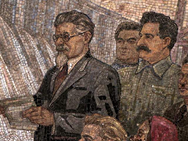
Kievskaya Station went public in March of 1937, the rails between it and Park Kultury Station being the first to cross the Moscow River. Kievskaya is full of mosaics depicting aristocratic scenes of Russian life, with great cameo appearances by Lenin, Trotsky, and Stalin. Each work has a Cyrillic title/explanation etched in the marble beneath it; however, if your Russian is rusty, you can just appreciate seeing familiar revolutionary dates like 1905 ( the Russian Revolution ) and 1917 ( the October Revolution ).
Mayakovskaya Station
Mayakovskaya Station ranks in my top three most notable Metro stations. Mayakovskaya just feels right, done Art Deco but no sense of gaudiness or pretention. The arches are adorned with rounded chrome piping and create feeling of being in a jukebox, but the roof’s expansive mosaics of the sky are the real showstopper. Subjects cleverly range from looking up at a high jumper, workers atop a building, spires of Orthodox cathedrals, to nimble aircraft humming by, a fleet of prop planes spelling out CCCP in the bluest of skies.
Novoslobodskaya Station
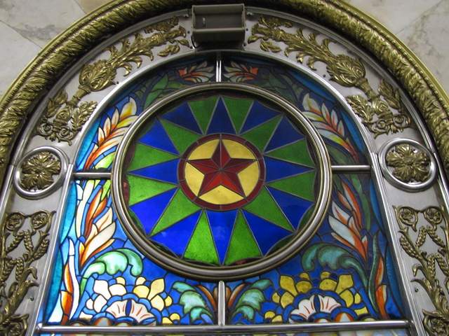
Novoslobodskaya is the Metro’s unique stained glass station. Each column has its own distinctive panels of colorful glass, most of them with a floral theme, some of them capturing the odd sailor, musician, artist, gardener, or stenographer in action. The glass is framed in Art Deco metalwork, and there is the lovely aspect of discovering panels in the less frequented haunches of the hall (on the trackside, between the incoming staircases). Novosblod is, I’ve been told, the favorite amongst out-of-town visitors.
Komsomolskaya Station
Komsomolskaya Station is one of palatial grandeur. It seems both magnificent and obligatory, like the presidential palace of a colonial city. The yellow ceiling has leafy, white concrete garland and a series of golden military mosaics accenting the tile mosaics of glorified Russian life. Switching lines here, the hallway has an Alice-in-Wonderland feel, impossibly long with decorative tile walls, culminating in a very old station left in a remarkable state of disrepair, offering a really tangible glimpse behind the palace walls.
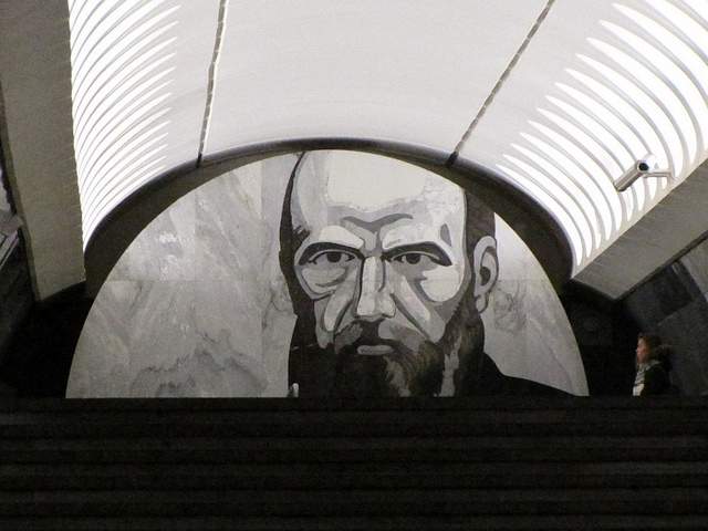
Dostoevskaya Station
Dostoevskaya is a tribute to the late, great hero of Russian literature . The station at first glance seems bare and unimpressive, a stark marble platform without a whiff of reassembled chips of tile. However, two columns have eerie stone inlay collages of scenes from Dostoevsky’s work, including The Idiot , The Brothers Karamazov , and Crime and Punishment. Then, standing at the center of the platform, the marble creates a kaleidoscope of reflections. At the entrance, there is a large, inlay portrait of the author.
Chkalovskaya Station
Chkalovskaya does space Art Deco style (yet again). Chrome borders all. Passageways with curvy overhangs create the illusion of walking through the belly of a chic, new-age spacecraft. There are two (kos)mosaics, one at each end, with planetary subjects. Transferring here brings you above ground, where some rather elaborate metalwork is on display. By name similarity only, I’d expected Komsolskaya Station to deliver some kosmonaut décor; instead, it was Chkalovskaya that took us up to the space station.
Elektrozavodskaya Station
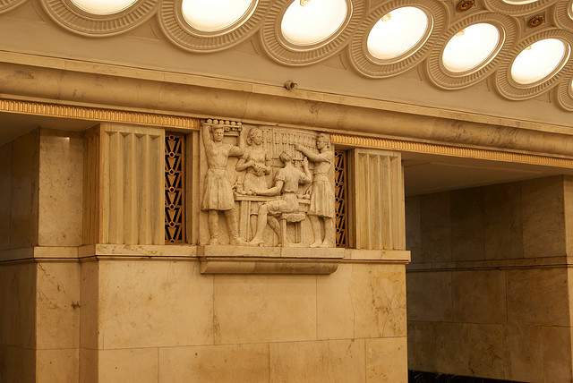
Elektrozavodskaya is full of marble reliefs of workers, men and women, laboring through the different stages of industry. The superhuman figures are round with muscles, Hollywood fit, and seemingly undeterred by each Herculean task they respectively perform. The station is chocked with brass, from hammer and sickle light fixtures to beautiful, angular framework up the innards of the columns. The station’s art pieces are less clever or extravagant than others, but identifying the different stages of industry is entertaining.
Baumanskaya Statio
Baumanskaya Station is the only stop that wasn’t suggested by the students. Pulling in, the network of statues was just too enticing: Out of half-circle depressions in the platform’s columns, the USSR’s proud and powerful labor force again flaunts its success. Pilots, blacksmiths, politicians, and artists have all congregated, posing amongst more Art Deco framing. At the far end, a massive Soviet flag dons the face of Lenin and banners for ’05, ’17, and ‘45. Standing in front of the flag, you can play with the echoing roof.
Ploshchad Revolutsii Station
Novokuznetskaya Station
Novokuznetskaya Station finishes off this tour, more or less, where it started: beautiful mosaics. This station recalls the skyward-facing pieces from Mayakovskaya (Station #2), only with a little larger pictures in a more cramped, very trafficked area. Due to a line of street lamps in the center of the platform, it has the atmosphere of a bustling market. The more inventive sky scenes include a man on a ladder, women picking fruit, and a tank-dozer being craned in. The station’s also has a handsome black-and-white stone mural.
Here is a map and a brief description of our route:
Start at (1)Kievskaya on the “ring line” (look for the squares at the bottom of the platform signs to help you navigate—the ring line is #5, brown line) and go north to Belorusskaya, make a quick switch to the Dark Green/#2 line, and go south one stop to (2)Mayakovskaya. Backtrack to the ring line—Brown/#5—and continue north, getting off at (3)Novosblodskaya and (4)Komsolskaya. At Komsolskaya Station, transfer to the Red/#1 line, go south for two stops to Chistye Prudy, and get on the Light Green/#10 line going north. Take a look at (5)Dostoevskaya Station on the northern segment of Light Green/#10 line then change directions and head south to (6)Chkalovskaya, which offers a transfer to the Dark Blue/#3 line, going west, away from the city center. Have a look (7)Elektroskaya Station before backtracking into the center of Moscow, stopping off at (8)Baumskaya, getting off the Dark Blue/#3 line at (9)Ploschad Revolyutsii. Change to the Dark Green/#2 line and go south one stop to see (10)Novokuznetskaya Station.
Check out our new Moscow Indie Travel Guide , book a flight to Moscow and read 10 Bars with Views Worth Blowing the Budget For
Jonathon Engels, formerly a patron saint of misadventure, has been stumbling his way across cultural borders since 2005 and is currently volunteering in the mountains outside of Antigua, Guatemala. For more of his work, visit his website and blog .

Photo credits: SergeyRod , all others courtesy of the author and may not be used without permission
Your last-minute guide to Monday's total solar eclipse

A total solar eclipse will cross North America on Monday , offering millions a rare opportunity to see afternoon skies temporarily darken as the moon blocks the face of the sun.
Tune into NBC News NOW as Lester Holt hosts a two-hour special at 2 p.m. ET Monday from Indianapolis Motor Speedway.
The eclipse's path fortuitously cuts across Mexico, 15 U.S. states and a small part of eastern Canada. In all other states in the continental U.S., viewers will be treated to a partial solar eclipse, with the moon appearing to take a bite out of the sun and obscuring part of its light.
Here’s everything you need to know about the rare celestial event.
What is a solar eclipse?
Solar eclipses occur when the sun, moon and Earth align. The moon passes between Earth and sun, temporarily blocking the sun’s light and casting a shadow on Earth.
A total solar eclipse is when the moon fully obscures the sun, whereas a partial solar eclipse means it blocks just a portion of the sun’s face.
Solar eclipses occur only with the new moon. Because the moon’s orbit around Earth is tilted, the three bodies don’t always line up in a way that creates an eclipse.
“Imagine if the moon’s orbit were in the plane of Earth’s orbit around the sun — if that were the case, then every new moon, you’d have a total solar eclipse and every full moon, you’d have a lunar eclipse,” Neil DeGrasse Tyson, director of the Hayden Planetarium at the American Museum of Natural History, told NBC News. “So, because things don’t always align, it lends to the rarity of the event and the specialness of the event.”
Where and when will the eclipse be visible?
This year’s eclipse will follow a slightly wider path over more populated areas of the continental U.S. than other total solar eclipses have in the recent past.
NASA estimates that 31.6 million people live within what’s known as the path of totality, where the total solar eclipse will be visible. An additional 150 million people live within 200 miles of the path, according to the agency.
The path travels through Texas, Oklahoma, Arkansas, Missouri, Illinois, Kentucky, Indiana, Ohio, Pennsylvania, New York, Vermont, New Hampshire and Maine. Tiny parts of Michigan and Tennessee will also be able to witness totality if conditions are clear.
After the eclipse crosses into Canada, it will pass over southern Ontario, Quebec, New Brunswick, Prince Edward Island and Cape Breton, at the eastern end of Nova Scotia.
Those outside the path of totality can still take part in the astronomical event by viewing a partial solar eclipse — visible throughout all 48 states of the contiguous U.S. — or a NASA livestream.
The timing, including how long totality lasts, depends on the location, but some spots will see the moon fully cover the sun for up to 4 minutes and 28 seconds.
Below is a list of timings for some cities along the path of totality, as provided by NASA . A number of other resources, including NationalEclipse.com and TimeandDate.com , can also help people plan.
- Dallas: Partial eclipse begins at 12:23 p.m. CT and totality at 1:40 p.m.
- Little Rock, Arkansas: Partial eclipse begins at 12:33 p.m. CT and totality at 1:51 p.m.
- Cleveland: Partial eclipse begins at 1:59 p.m. ET and totality at 3:13 p.m.
- Buffalo, New York: Partial eclipse begins at 2:04 p.m. ET and totality at 3:18 p.m.
- Lancaster, New Hampshire: Partial eclipse begins at 2:16 p.m. ET and totality at 3:27 p.m.

How to safely view a solar eclipse
It is never safe to gaze directly at the sun, even when it is partly or mostly covered by the moon. Special eclipse glasses or pinhole projectors are required to safely view solar eclipses and prevent eye damage. Failing to take the proper precautions can result in severe eye injury, according to NASA .
Eclipse glasses are thousands of times darker than normal sunglasses and specially made to enable wearers to look at the sun during these kinds of celestial events.
Sky-watchers should also never view any part of the sun through binoculars, telescopes or camera lenses unless they have specific solar filters attached. Eclipse glasses should not be used with these devices, as they will not provide adequate protection.
However, during the few minutes of totality, when the moon is fully blocking the sun, it is safe to look with the naked eye.

Beware of fake eclipse glasses. On legitimate pairs, the lenses should have a silver appearance on the front and be black on the inside. The manufacturer’s name and address should be clearly labeled, and they should not be torn or punctured. Check, as well, for the ISO logo and the code “IS 12312-2” printed on the inside.
If you don’t have eclipse glasses, you can make a homemade pinhole projector, which lets sunlight in through a small hole, focuses it and projects it onto a piece of paper, wall or other surface to create an image of the sun that is safe to look at.
All you need is two pieces of white cardboard or plain white paper, aluminum foil and a pin or thumbtack. Cut a 1- to 2-inch square or rectangle out of the center of a piece of white paper or cardboard. Tape aluminum foil over that cut-out shape, then use a pin or thumbtack to poke a tiny hole in the foil.
During the eclipse, place a second piece of white paper or cardboard on the ground as a screen and hold the projector with the foil facing up and your back to the sun. Adjusting how far you hold the projector from the second piece of paper will alter the size of the image on the makeshift screen.
What to look for while viewing the total solar eclipse
For people along the path of totality, there are some fun milestones to keep track of as the total solar eclipse unfolds.
As the eclipse progresses and the sun gets thinner in the sky, it will start to get eerily dark, according to Tyson.

When the last beams of sunlight are about to become obscured, look out for the “diamond ring effect”: The sun’s atmosphere will appear as an illuminated halo, and the last light still visible will look like the diamond of a giant ring.
As the sunlight decreases even further, an effect known as Baily’s beads will be created by the moon’s rugged terrain. Tiny “beads” of light will be visible for only a few seconds around the dark moon, as the last bits of sunlight peer through the moon’s mountains and valleys.
When the moon is fully blocking the sun, it is safe to remove eclipse glasses and look at the total solar eclipse with the naked eye.

Some lucky sky-watchers may even catch a glimpse of a comet .
Comet 12P/Pons-Brooks — nicknamed the “ devil comet ” because an eruption last year left it with two distinct trails of gas and ice in the shape of devil horns — is currently visible from the Northern Hemisphere as it swings through the inner solar system.
The comet can be seen in the early evenings by gazing toward the west-northwest horizon. During the eclipse, when skies darken during totality, it may be possible to see the comet near Jupiter, but its visibility will depend on whether it’s in the middle of an outburst and thus brighter than normal.
Most likely, all eyes will be on the alignment of the moon and sun.
“Most people won’t even notice,” Tyson said. “But if you know to look, it’s there.”
When is the next solar eclipse?
The next total solar eclipse will be in 2026, but it will mostly pass over the Arctic Ocean, with some visibility in Greenland, Iceland, Portugal and northern Spain. In 2027, a total solar eclipse will be visible in Spain and a swath of northern Africa.
The next total solar eclipse visible from North America will be in 2033, but only over Alaska. Then in 2044, a total solar eclipse will cross Montana, North Dakota, South Dakota, parts of Canada and Greenland.
The next total solar eclipse to cross the continental U.S. coast-to-coast in will occur in 2045. The path of totality for that eclipse will cut through California, Nevada, Utah, Colorado, New Mexico, Oklahoma, Kansas, Texas, Arkansas, Missouri, Mississippi, Louisiana, Alabama, Georgia and Florida.
Denise Chow is a reporter for NBC News Science focused on general science and climate change.
Lucas Thompson is a content producer for the NBC News Climate Unit.
IMAGES
VIDEO
COMMENTS
Track your travel, mark visited countries and create your own world map. Plan your travel adventures, add bucket list destinations to your wishlist and share your travel goals with your friends and family using our interactive map tool. Share this page. Share the Page: Copy and share this unique URL:
Hit Enter or click the magnifying glass and a list of your search results will appear on the left. Click the name in the list, or on the pin that appears on the map, and an info box will pop up. Then click Add to map. Repeat this step for as many locations as you want to add to your map. Just search for a location….
Track your experiences by country such as where you've gone golfing, snorkelling/diving, skiing, wine tours and others. Keep up with your travel life goals by selecting all the countries of the world that you want to visit. Add travel journal notes by country of your travel dates, points of interest or personal memories.
Use Wanderlog to share your itinerary with tripmates, friends, and families and collaborate in real time, so everyone stays in the loop. Plan your road trip or vacation with the best itinerary and trip planner. Wanderlog travel planner allows you to create itineraries with friends, mark routes, and optimize maps — on web or mobile app.
Map and visualise your trips. It's fast, simple, fun and free. Start mapping your trips now! Plan your upcoming trips and map previous travels. Add notes, photos and blog entries to build a rich story of your travels. Embed your trip map on your own blog. Save your map as a high resolution image. Draw custom routes between your trip stops.
Make maps. Easily create custom maps with the places that matter to you. Add points or draw shapes anywhere. Find places and save them to your map. Instantly make maps from spreadsheets. Show your ...
Check the Google icon in the top right corner to make sure you're using the Google account you want to. Click "Create A New Map" and a window will open with a blank map. To give your map a name and description, click the map name ("Untitled Map"). You can also change the color and style of the base map if desired.
One of the key features of Map My Travels is to customize the way you want to show waypoints on your travel map. That's why you can add markers to your map in multiple ways: Create your own using the custom marker builder. Customize the marker icon and border and fill colors. Upload your own marker icon and resize it to your needs.
from $149.99 USD. Gallery Wrapped - Blue Oceans World Travel Map with pins. 59 reviews. from $199.99 USD. Vintage World Push Pin Travel Map with pins. 171 reviews. from $149.99 USD. 3 Panel - Earth Toned World Travel Pin Map. 18 reviews.
Create your online travel map. Store your memories and ideas in one place by pinning all the places around the world you've been to or want to visit. ... Use Visited map as your personal travel journal and drop a pin on every place you went to. No need to remember everything in your head. See how much of the world you have already conquered!
How It Works. Enter where you started. Type the name of a landmark, an address, coordinates, or drag-n-drop a point onto the map. Add the first stop to your online travel map the same way. Pick how you got there from a menu. Driving is blue. Flying is red. Hiking, green. You get the point.
Population : [10 000 000] Area : [74000]km2([0.05]% of the world) We have recently updated the world map and divided Australia, Brazil, Canada, China, Greenland, India, Russia, United Kingdom and United States on their states level. Since you have previously selected some of those countries, we had to remove them from your travel map.
More Africa & Middle East Destinations. Plan your trip with free itineraries, guides, activities and maps. Create your personal travel guide with full information on all attractions, shopping and more.
This Travel Map Generator uses Google Charts API to highlight individual countries on a map. The result is a PNG image like the one shown above. The colors are customizable. The size is restricted to 440x220 by the API. You can use this map on your website or blog. Just select colors and countries below to get your personal travel map.
Beat your own travel stats. Get inspired to visit exotic new destinations. Track your experiences around the world as you tick off your bucket list. MAP YOUR TRAVELS -Design your personal travel map by displaying countries, states / provinces / regions and cities of where you have been or want…
Add your travel destinations on a map, select your transport modes, visualize and share your itinerary for free. My itinerary This is a free demo version of our mapping software. Create an account to save your current itinerary and get access to all our features. ...
Add your itenary. You can start creating your map by adding destinations. Start typing in the input box and your destination will come up automatically. Once it appears, click on it to add it to your canvas. Don't forget to select your travel mode!
This map was created by a user. Learn how to create your own.
All inclusive, top of the line Original Personalized World Traveler Map. It is the gold standard push-pin travel map! It's a... Learn more. $ 179.00. Quantity. Add to Cart. Map Your Travels with personalized traveler maps complete with push pins to track your travels. Travel Quest Posters and travel map accessories also available.
5G is faster than 4G LTE, but actual speeds may vary depending on your device and network conditions. On average, 5G can deliver speeds 5x as fast as 4G LTE. Both 4G LTE and 5G coverage depend on how many towers are equipped with the right equipment. Today, T‑Mobile's 4G LTE coverage reaches 99% of Americans, with 5G close behind at 98% of ...
The Moscow metro is one of the busiest and most extravagantly decorated metro systems in the world. The current map, although functional, does not contain any personality nor does it let visitors know where many point of interest are located. The new design infuses elements of the culture into the map, logo, and signage to create a cohesive system.
Hotels near Statue of Lenin, Elektrostal on Tripadvisor: Find 1,357 traveler reviews, 1,945 candid photos, and prices for 60 hotels near Statue of Lenin in Elektrostal, Russia.
Have a look (7)Elektroskaya Station before backtracking into the center of Moscow, stopping off at (8)Baumskaya, getting off the Dark Blue/#3 line at (9)Ploschad Revolyutsii. Change to the Dark Green/#2 line and go south one stop to see (10)Novokuznetskaya Station. Check out our new Moscow Indie Travel Guide, book a flight to Moscow and read 10 ...
The eclipse's path fortuitously cuts across Mexico, 15 U.S. states and a small part of eastern Canada. In all other states in the continental U.S., viewers will be treated to a partial solar ...
Get directions to Yuzhny prospekt, 6к1 and view details like the building's postal code, description, photos, and reviews on each business in the building