- © Roadtrippers
- © Mapbox
- © OpenStreetMap
- Improve this map

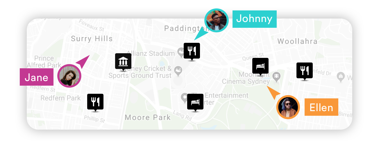
My itinerary
This is a free demo version of our mapping software.
Create an account to save your current itinerary and get access to all our features.
Otherwise your data will be automatically deleted after one week.
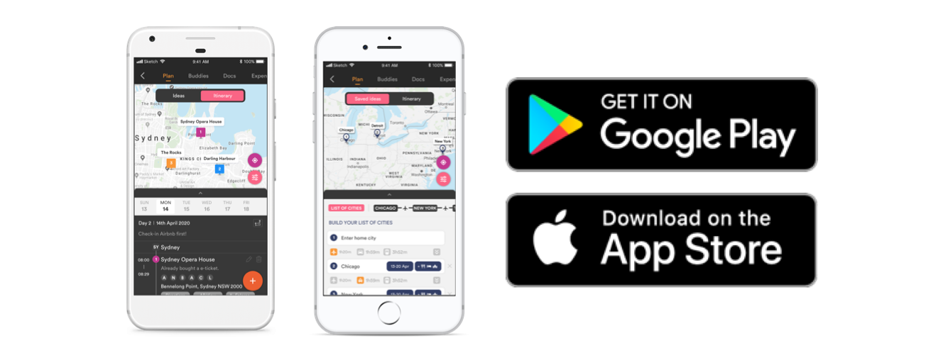
Download Pebblar APP Now

Collaborative map-based itinerary planner
From idea mapping to detailed itinerary planning, have everything on one map. collaborate with your trip buddies in real time.

Build your list of cities

Save ideas under each city

Create daily itinerary

Road-trip mapping
The easiest way to map and track your next road-trip with unlimited stops; travel distances automatically calculated and fully integrated mobile apps for on-the-road access

European holidays
From putting together your list of cities and travel ideas to creating a detailed itinerary; from pre-trip planning to on-trip access – all done in one place

Professional quality PDF
Professional quality PDF (with your own logo) or access via our iOS / Andriod apps

Saving travel ideas
One centralised place to store all your travel ideas even if you don't have a clear travel date
Other cool features
Real-time collaboration and team coordination
Access anywhere with our fully integrated mobile apps
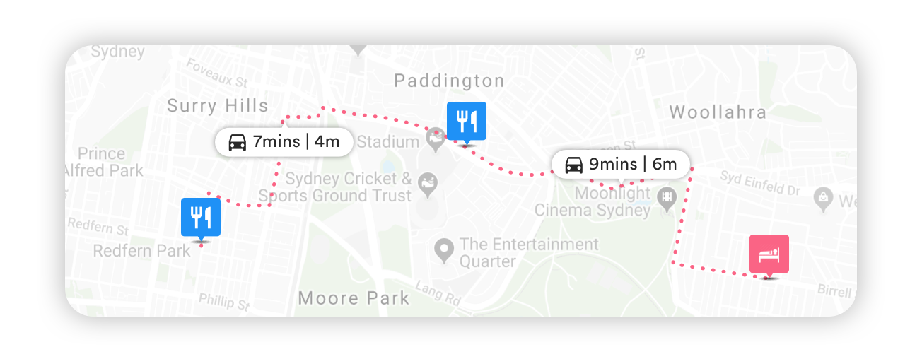
Automatic travel time and distance display
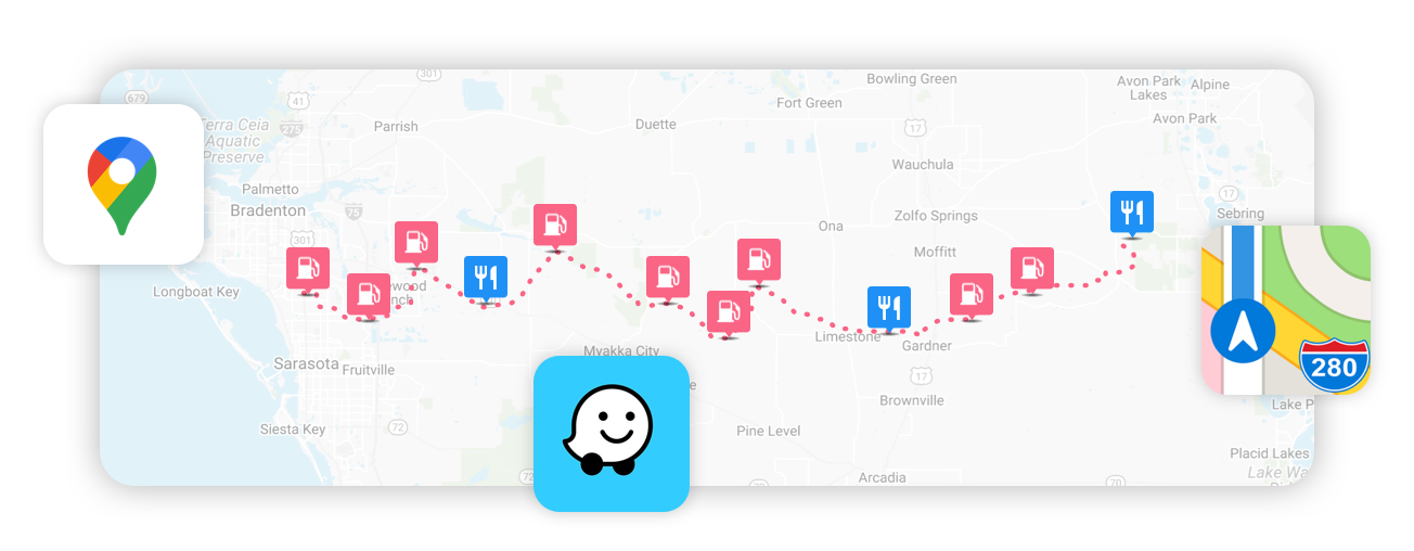
Integrated with 3 leading navigation apps: Google Maps, Waze and Apple Maps, as well as Ford vehicle integration
As featured in

Testimonials
“You seriously cannot find a more effective travel planning tool than Pebblar. Gone are the days of screenshots of maps and messy collages of travel notes on maps. Forget about typing up collective itineraries on word, Pebblar is the exciting new tool for effective multi-destination travel planning. It syncs all the useful information internet has to offer perfectly into an easy simple to use App. Brilliant.”
"Throughout my day, I am constantly fantasizing about travel in my head. Whether for an upcoming or far-future trip, I use Pebblar to keep track of the cities I want to visit, sites I want to see, restaurants I want to try; and to plan the possible path between location. Pebblar is amazing for helping me organize my ideas in easy, virtual form." Chloe Skye
"The Google Maps integration is excellent and we can easily print off a whole itinerary before we leave, or use the app when we get there to help us get around and have a smooth journey. I would recommend Pebblar to anyone planning an upcoming trip." Rufus Holmes
5 Travel Planning Apps With Live Maps to Plot a Trip Itinerary
These free travel planning apps show all your activities and attractions on a live map and help you plot an itinerary.
Since the pandemic, you need to plan your trips carefully. So many things can change in no time, and people, in general, are traveling more, so advance bookings are crucial. These travel planning apps will help you plot an itinerary and ensure you don't miss out on any activities or attractions.
All the apps in this list come with maps that show all the locations you're traveling to. It's much better than using a Google Doc to write out your plan. Each app does something a little different or better than the others, so you'll likely find exactly what you're looking for in a travel planning app.
1. Scout (Web): Best Travel Planner for Cities With Detailed Map
When you're planning a trip to a new city, either alone or as a group, you will usually list many places you want to visit. With Scout, you can add these in different sections and see them on a live map, thus making it easier to figure out which places are within close distance and create an itinerary.
When you start a new trip in Scout, you'll first have to pick a city you're visiting and set your arrival and departure dates. By default, you get sections for attractions, food, and accommodations. But you can always add more custom sections. Each section gets its colored pin marker (for example, all food places will show as blue pins). You can add a place by searching for it or typing out the full address. It's powered by Google Maps, so it'll be easy to find any place.
Once you've added the points of interest, open the itinerary view to see your dates. Drag-and-drop places from the first bar to any day's itinerary. Once you add multiple places to a day, the map will automatically create a route for that day, linking all the places. You can rearrange them to find the best route to take.
You can also share your Scout trip with others, so that they can add their own points of interest and update the itinerary to create a group plan. It's also a helpful way to get tips from locals, as they'll be able to add recommendations directly to your map.
Scout also lets you publish your map or itinerary to its directory so that others can discover your helpful recommendations. And of course, you can browse the directory to find what others have recommended.
2. Puffin (Web): Find the Best Commute or Route for Your Travel Itinerary
Puffin is similar to Scout, with a few minor differences. When you create a new trip in Puffin and add a city, it automatically gives you a few recommendations for interesting and unique tourist spots , which show up as flowers on the map. Then, you start adding places of interest by searching for them in the left sidebar when set to Places, after which they'll show up as pins on the map.
Once you've added all the pins you want, switch the sidebar from Places to Itinerary. Create a new "day" and drag places from the map to that day. Puffin will automatically create a commute for you in the order of the places. Rearrange the places to get a better commute. You can also set a custom color for all the places and routes for a day.
For a detailed view of your entire itinerary, toggle the "View Full Schedule" button at the top of the sidebar. This will show a kanban board-like view of all your days. You can quickly drag and drop places between different days.
Puffin trips can also be shared between friends to build a trip collaboratively. Other users can comment on any place, so you can have a chat within Puffin on whether that place is worth going to or not.
3. Travel Trove (Web): Detailed Travel Planner for Multi-City Trips
Travel Trove is an excellent app if you go to a new country and plan to visit multiple cities. First, add the country you'll be going to, and then add the places you want to visit. For example, if you were going to Italy, search for the Colosseum and for the Leaning Tower of Pisa, and add both. Then, in your sidebar, Travel Trove will automatically list them under the different cities of Rome and Pisa.
For every place you add, you can also put in a few notes about it. Travel Trove also automatically scrapes information from Google Maps like the website, timings, and address of that place.
Once you've added all the places, switch to itinerary mode (and select all the cities in your trip when prompted). Now you'll be building a day-by-day itinerary for your visit. Each day has an "accommodation" slot and more slots for AM and PM to plan your holidays. Simply drag-and-drop your places to these slots to build the plan. You can also add notes for each day.
Travel Trove lets you quickly filter places by categories you have set while adding them, like must-visit, food, accommodation, etc. You can also add Packing Notes to your itinerary to ensure you don't forget anything. Once you're done with the travel plan, you can share it with others too.
4. Travel Mapper (Web): Google Sheets Travel Itinerary With Live Map
When you're planning the itinerary for your next trip, you usually want to visualize it on Google Maps too. Travel Mapper is a custom Google Sheets template that lets you create your travel itinerary, share it with friends, and instantly add the locations to Google Maps.
Travel Mapper is simple to use. Once you download the add-on, open a new Google Sheet and go to Extensions > Travel Mapper > Start Here > Generate Template . Add the date, time, activity, location, links, costs, and any additional notes in the sheet. The sidebar shows the Google Map for your itinerary, which you can update when you make any changes.
The map is customizable. You can add color codes for different elements and filter activities to see your map differently. The Google Maps in the sidebar can also be used to discover other places of interest nearby to any location. It's one of the best Google Maps hacks for travel trips .
Travel Mapper also includes a to-do list, a packing checklist, and a favorites list to ensure you don't forget anything. You can also share your newly created sheet with friends, who can add their own locations to the map.
5. Plip (Web, Android, iOS): Mobile-First Collaborative Trip Planner With Maps
The apps mentioned above in this list are all made to be used on computers. However, Plip bucks the trend by being a mobile-first travel planning app so that you can plan your entire trip on your phone or tablet. Plip also has a web app if you want to use it on your laptop.
Register for an account once you create a new trip; otherwise, your travels won't be saved. You can keep the trip private or share it with a group by adding others' emails.
When you want to add a new entry, there are eight types of plans to choose from: plan (generic), flight, reservation, lodging, restaurant, event, vehicle rental, and transit. The default details to fill for any entry are the title, the location, the start and end date and time, and any notes if necessary. Certain plans have additional entries, like "Provider" in events or "Confirmation number" in lodgings.
You can quickly filter your entries by the type of plan to view them in a list. Otherwise, switch to the Map view to view all your places of interest marked on the map, and scroll through a pane at the bottom.
Download: Plip for Android | iOS (Free)
Plan Well, But Look for Last Minute Deals
These apps will help plan out your entire trip, giving you a clear idea of when and where you will be. But don't yet rush to book it all.
The travel and hospitality industry has a lot of last-minute deals on flights, hotels, and tourist attractions. You should try to take advantage of these where you can. Since you will plan out your trip, add a few alternatives or flexible dates with flexible itineraries so that you can wait a bit more and benefit from these deals.

- Scenic Drives
- Road Trip Planner
Road Trip Planning Made Easy
Create custom day trips, weekend getaways, and cross country adventures worldwide
Powerful features for planning your epic road trips (and the shorter adventures in between)
Unlimited stops.
Add unlimited stops and sub-stops. Combine your own stops with our pre-planned routes and recommended places of interest.
Smart Scheduling
By the minute, hour, or overnight, set preferences for each stop. Export your trip to your own Calendar.
Set Vehicle Type
Car, RV, camper trailer, truck, motorcycle, pulling a boat? Get a realistic estimate of driving time. Adjust travel speed by percentages for each unique situation.
Divide Trips Into Days
Divide your trips into manageable driving days based on your custom settings by time or distance. And of course you can customize each day differently.
Route Preferences
Configure route preferences such as avoiding highways or tolls for each day or any segment of your trip.
Use Any Device
Plan trips from your desktop computer, iPad, Android tablet, and mobile phone with the same easy-to-use interface. No app to download or software to install.
Automated To Do List guides you through the road trip planning process.
Manage Your Budget
Track expenditures before you go and along the way. See a summary of expenses for entrance fees, activities, restaurants, and lodging, etc.
Gas Calculator
See the estimated fuel cost for your vehicle type.
EV Charging
Find EV charging stations along your route. Get reminders to recharge. Use Charging Ranges to display icons on the map where your vehicle will require recharging.
Export Options
We support Google Earth (KML), Garmin Communicator, BaseCamp and MapSource (GPX), Co-Pilot Live (TRP), Microsoft Streets and Trips, TomTom itineraries (ITN), TomTom Places of Interest (OV2), Comma Separated Files (CSV), and Tab Separated Files (TSV).
Directions on paper come in handy. Print your road trip with turn-by-turn maps and full directions, divided into your day-by-day itinerary.
Is This Really Free?
Yes! It is free to use our Scenic Drive Itineraries and Road Trip Planner. Please consider purchasing your National Park or National Forest passes on myscenicdrives.com.
Why Do I Need An Account?
A free account is only required for the Road Trip Planner, enabling you to create, edit, and save your trips. Your account is secure. We never share your information.
Do I Need to Download An App or Install Software?
No app or software is needed. myscenicdrives.com works in any browser. Simply go to myscenicdrives.com
More Resources
Documentation, myscenicdrives.com, how it works.

Plan epic road trips
Plan multi-stop routes.
Easily plan your trip itinerary on an interactive map and see distances and driving times
Find places along the route
Find attractions, restaurants or accomodation along your driving route
Find inspiration
Explore our growing collections of ready-made road trip routes.
Share your itinerary
Invite family and friends to plan your route together. Or share your trip itinerary as a neat document

Discover Inspiring Routes
Explore our curated selection of epic road trips for every taste. Get inspired and use our guides as templates for your own planning.

Plan Your Road Trip
Build the perfect trip itinerary and pin as many locations on the map as you like. You’ll see distances connecting the waypoints and know the driving times between multiple stops. Search points of interest like attractions, trails, or national parks. Choose if you’re traveling by car or RV to optimize your route accordingly.
Account Options
Route planner
Driving directions.
The route deemed to be the safest and simplest with minimal scope for error along the way. The default recommended route from Michelin.
The route offering the shortest distance to a destination via the most accessible roads. Journey times for this option will tend to be longer.
The most fuel-efficient route that also avoids toll roads.
My cost options
- B7 (Diesel)
- E5 (Unleaded)
- E85 (superethanol)
- CNG (Biomethane)
- H2 (Hydrogen)
My route options
- E5 (Unleaded) €1.700
- Route : Fast
- Distance in : Kilometres
- No restrictions
- Route from this place
- Directions to this place
- Route via this place
- Nearby hotels
- Nearby restaurants
Renting a car, an attractive proposition for the holidays

Monthly Report

Eco-mobility

Keep in contact
My michelin account.
Work in progress.
World Trip Planner
Plan your next round-the-world trip.
Use PlanYourTrip to prepare for you next Adventure. With this page you can try out this application to find out about it's advantages. After registration your Trip can be saved. Have fun planning your next World Trip with the PlanYourTrip Planner.
You still need some inspiration for your personal travel planning? Just take a look at our sample trips!
- Backpacking Group Tours
- Flashpacking Group Tours
- Premium Group Tours
- All Group Tours
- Get a Quote
- Destinations
- Sustainability
- Gift Vouchers
- Educational Trips
Europe Trip Planner
Euroventure specialises in multi-city europe trips – specifically interrail and eurail adventures., check out our resources and tools below to help you plan your european escape.
It can be really overwhelming trying to plan your Europe trip. There are a ton of things to work out, research and eventually book. That’s why we offer as many resources and services as possible. From planning tools and rail trip advice, to fully guided tours , we can help you plan your ultimate Europe trip on your terms.
Use our interactive Europe Trip Planner tool to create your own route.
Use our Europe trip planner map to create your own self-guided route, including any major European destinations – plus some further afield including Russia and China!
The map tool is interactive and super easy to use; you can make a plan without any obligation to book your trip with us. We’ll then send you over our best ideas for your route, plus a price including all your trains and accommodation. If you like the idea of having your multi-destination trip planned for you, you can book it within minutes! If not, no problem – you can still use the planner.
Not sure which destinations to visit? Get some inspiration with our destination guide !
")
Planning a trip to Europe but need some inspiration? Take a look at our self-guided itineraries.
Choose the route you like the best, and we’ll plan your Europe trip. You travel on your own, or with friends, but we’ll organise everything and send it all to you in a handy travel pack. We can also book activities, attractions and excursions for you. All you have to arrange is a flight to and from your start/finish point, plus your travel insurance (which you can sort through our partners here ) and spending money. Find out roughly how much spending money to take .
Wherever we can, we use trains to get from A to B. They’re the most sustainable, sociable and convenient way to get around – and we’ve got deals with all the main providers plus a ton of expert knowledge! Read more about travelling Europe by train – or check out our comparison of different ways to travel Europe for more inspiration. Scroll down for Europe trip itineraries from 1 – 8 weeks or longer!
If you prefer to travel with likeminded backpackers, why not join one of our small group trips across Europe: Find out more.
WhatsApp us

Australia Recommends 2024

Come and Say G'day

G'day, the short film

Discover your Australia

Travel videos

Deals and offers

Australian Capital Territory

New South Wales

Northern Territory

South Australia

Western Australia
")
External Territories

The Whitsundays

Mornington Peninsula

Port Douglas

Ningaloo Reef

Airlie Beach

Kangaroo Island

Rottnest Island
, QLD © Tourism & Events Queensland")
Hamilton Island

Lord Howe Island

Tiwi Islands

Phillip Island

Bruny Island

Margaret River

Barossa Valley

The Grampians

Hunter Valley

McLaren Vale

Glass House Mountains

Alice Springs

Uluru and Kata Tjuta

The Kimberley

Flinders Ranges

Kakadu National Park

Eyre Peninsula

Karijini National Park

Great Barrier Reef

Blue Mountains

Daintree Rainforest

Great Ocean Road

Purnululu National Park

Cradle Mountain-Lake St Clair National Park

Litchfield National Park

Aboriginal experiences

Arts and culture

Festivals and events

Food and drink

Adventure and sports

Walks and hikes

Road trips and drives

Beaches and islands

Nature and national parks

Eco-friendly travel

Health and wellness

Family travel

Family destinations

Family road trips

Backpacking

Work and holiday

Beginner's guide

Accessible travel

Planning tips

Trip planner

Australian budget guide

Itinerary planner

Find a travel agent

Find accommodation

Find transport

Visitor information centres
Deals and travel packages

Visa and entry requirements FAQ

Customs and biosecurity

Working Holiday Maker visas

Facts about Australia

Experiences that will make you feel like an Aussie

People and culture

Health and safety FAQ

Cities, states & territories

Iconic places and attractions

When is the best time to visit Australia?

Seasonal travel

Events and festivals

School holidays

Public holidays

How to get to Australia's most iconic cities

How long do I need for my trip to Australia?

How to travel around Australia

Guide to driving in Australia

How to hire a car or campervan

How to plan a family road trip

How to plan an outback road trip


- About Us
- Advertising & Affiliates
- Legal Notices
- Printed Maps
- Books & Gear
- Trip Reports
- Recent Activity
Interactive Map

Icons and Legend
- Open Campsites Reviewed Not Reviewed
- Closed Campsites Reviewed Not Reviewed
- Nonexistent Campsites Reviewed Not Reviewed
- Entry Points
- Overnight Paddle Only
- Overnight Paddle or Motor
- Day Use Motor
- Overnight Hiking
- Points of Interest Overlook Fishing Spot Pictograph Dam Warning Note Waterfall River Gauge Other
- Photos
- Ranger Stations
- Portages
- Hiking Trails
- Roads
- Canoe Routes
- Boundaries
- Motorized Areas 10 HP Limit 25 HP Limit No HP Limit
- Primitive Management Areas (PMA)
- Burn Areas
- Rapids
- Fishing Spots
Route Builder Settings

Other Options
Please visit the downloads page for a list of KMZ and GPX files that you can use.
Portage Information
Elevation chart, my comments, entry point information, nearby outfitters.
Your browser does not support iframes.
Trip Reports
Lake information, point of interest.
Campsite Information
Pcd ratings, route points, saved routes.
To delete any routes, go to your Saved Routes page in your account.
Calculation Results
Route finder area calculation.
The Route Finder Area calculation is similar to the Route Finder but in reverse. The Route Finder calculates the distance and time from one point to another. The Route Finder Area calculation finds the points you can reach within a certain time or distance. The calculation is performed using the first point on the route points list and the settings below.
Route "Movie" (experimental)
The route "movie" will show a little canoe going along your calculated route and popup photos along the way. This is still something we are experimenting with, but it was so much fun (and strangely addicting) that we thought we'd share what we have so far.
Since it is still in development, it does not work perfectly. We know some of the problems, but please let us know if something doesn't work right or if you have suggestions to make it better.
When this is final, it will probably be for the paid memberships. During the development stage, though, anybody can use it.
- Calculate a route
- Turn the background and markers on or off that you want showing in the "movie" by using the map options in the upper left corner.
- Do you want the green route line showing? Turn it on or off using these buttons:
- If you don't have a mouse wheel that can be used to adjust the zoom, change the zoom level to what you want before beginning the movie (all toolbars will be hidden). You don't need to worry about centering since that will be done automatically.
- Start the movie!
- It will take a little while for the controls to show up. Once the photos are loaded, a control bar will appear at the bottom of the screen. Press the play button.
- You can adjust the speed using the speed dial near the bottom of the screen. The default is 60x - for every second the movie runs, the canoe moves 60 seconds along the route.
- When finished, press the X in the lower right corner. For now, if you want to rerun the movie with the photos, you'll have to exit out and start the movie again. We're working on making that process better.
Outfitters Near Entry Point
Campsites along route, lakes along route, portages on route, maps covering route, photos near route, report errors.
This is a "Map Enthusiast" feature. Upgrade now!
Multiple destinations in the RouteFinder is a "Map Enthusiast" feature. Upgrade now!
Because of the extensive resources and time necessary to perform this calculation, the limits for this tool are:
- 4 hours (8 hours for "Map Enthusiasts") or
- 12 miles (~19 km) (24 miles for "Map Enthusiasts")
Upgrade now to increase the tool limits!
This feature is not available in the trial version. Upgrade now!
- 216 miles (~348 km)
We have some video tutorials on our YouTube channel . You can watch them below or on YouTube .
If your question is not answered in the tutorials or you have a suggestion for us, please feel free to contact us .
Report Error or Map Correction
What type of error are you experiencing?
- A campsite is not shown on the map
- To fix a campsite location, first enter Explore mode by clicking on the Explore button in the upper left. Then zoom in on the map until you see the campsite in question. Click on the campsite. When the campsite summary shows up below the map, click on the summary to view the details. On the detail screen, you will see a button that says Change Location. Click on this button to view a screen that will allow you to select the correct location and send an email to the administrator. We will correct the map as soon as we can. If we have further questions, we will contact you.
- To fix a campsite location, first enter Explore mode by clicking on the Explore button in the upper left. Then zoom in on the map until you see the campsite in question. Click on the campsite. When the campsite summary shows up below the map, click on the summary to view the details. On the detail screen, you will see a button that says Report Open/Closed/Not a Campsite. Click on this button to view a screen that will allow you to send an email to the administrator. A default message will appear on the email screen; please modify it with your own explanation. We will correct the map as soon as we can. If we have further questions, we will contact you.
- I contributed to the old PCD (Quetico only) and would like my ratings associated with my Paddle Planner username
- I have a different issue with the maps
- I have an issue with the website in general
- Something else
No route has been calculated. First calculate a route before saving.
To manage your saved routes, go to your Saved Routes page in your account.
- Use the link on Facebook, Twitter, other social media, emails, your blog, website, or any other place you can post a link
- DO NOT use any links with your affiliate ID in places that commercial posting is not allowed, such as certain forums and messageboards
- Remember to disclose that you are an affiliate of the company
- Be aware of the commercial posting policies of the places you are putting the link
- If you are looking for banner ads or other visual materials, check out the affiliate materials page

Navigate forward to interact with the calendar and select a date. Press the question mark key to get the keyboard shortcuts for changing dates.
Navigate backward to interact with the calendar and select a date. Press the question mark key to get the keyboard shortcuts for changing dates.
Italy Trip Planner
Top destinations in italy.

Top attractions in Italy

Other notable attractions

Explore nearby places
- La Massimina-Casal Lumbroso
- Rocca Santo Stefano
- Cerreto Laziale
- Isola Farnese
- Torrimpietra
- Casal Palocco
- Ostia Antica
- Tragliatella
- Castel Romano
- Fonte Nuova
- Lido di Ostia
- Anguillara Sabazia
All related maps of Italy
- Map of Italy
- Map of La Massimina-Casal Lumbroso
- Map of Rocca Santo Stefano
- Map of Ladispoli
- Map of Rome
- Map of Cerreto Laziale
- Map of Gorga
- Map of Isola Farnese
- Map of Acilia
- Map of Torrimpietra
- Map of Maccarese
- Map of Casal Palocco
- Map of Fregene
- Map of Ostia Antica
- Map of Roiate
- Map of Tragliatella
- Map of Palidoro
- Map of Focene
- Map of Infernetto
- Map of Aranova
- Map of Cesano
- Map of Ciampino
- Map of Formello
- Map of Torre Gaia
- Map of Castel Romano
- Map of Fiumicino
- Map of Fonte Nuova
- Map of Lido di Ostia
- Map of Sacrofano
- Map of Anguillara Sabazia
- Map of Riano
Italy throughout the year
- Italy in January
- Italy in February
- Italy in March
- Italy in April
- Italy in May
- Italy in June
- Italy in July
- Italy in August
- Italy in September
- Italy in October
- Italy in November
- Italy in December
Q&A about Italy
Add places from guides with 1 click, collaborate with friends in real time, import flight and hotel reservations, expense tracking and splitting, checklists for anything, get personalized suggestions.
4.9 on App Store, 4.7 on Google Play
Bike Share Toronto 17+
Bike share toronto app, iphone screenshots, description.
This is the official mobile application for Bike Share Toronto, which is owned and managed by the Toronto Parking Authority. Download the app to: - Choose a pass or buy a membership - Find stations near you using the interactive map - Check bike and dock availability in real time - Plan a trip through Canada’s largest city - Easily unlock and return a bike - View your ride history With the Bike Share Toronto app, find choice, ease, and speed wherever you go!With the Bike Share Toronto app, find choice, ease, and speed wherever you go!
Version 15.56.31
Thanks for using Bike Share Toronto! We update our app regularly to make your rides even better. Every update of our Bike Share Toronto app includes improvements in speed and reliability. As new features are released, we'll highlight those for you in the app.
App Privacy
The developer, Lyft, Inc. , indicated that the app’s privacy practices may include handling of data as described below. For more information, see the developer’s privacy policy .
Data Linked to You
The following data may be collected and linked to your identity:
- Health & Fitness
- Financial Info
- Contact Info
- User Content
- Identifiers
- Diagnostics
Privacy practices may vary, for example, based on the features you use or your age. Learn More
Information
English, French, Portuguese, Spanish
- Developer Website
- App Support
- Privacy Policy
More By This Developer
Lyft Driver
BIKETOWNpdx
IMAGES
VIDEO
COMMENTS
Use Wanderlog to share your itinerary with tripmates, friends, and families and collaborate in real time, so everyone stays in the loop. Plan your road trip or vacation with the best itinerary and trip planner. Wanderlog travel planner allows you to create itineraries with friends, mark routes, and optimize maps — on web or mobile app.
The ultimate road trip planner to help you discover extraordinary places, book hotels, and share itineraries all from the map.
Provide up to 26 locations and Route Planner will optimize, based on your preferences, to save you time and gas money. Find the shortest routes between multiple stops and get times and distances for your work or a road trip. Easily enter stops on a map or by uploading a file. Save gas and time on your next trip.
Add your travel destinations on a map, select your transport modes, visualize and share your itinerary for free. My itinerary This is a free demo version of our mapping software. Create an account to save your current itinerary and get access to all our features. ...
From idea mapping to detailed itinerary planning, have everything on one map. Collaborate with your trip buddies in real time. Road trips. Vacations. STEP 1. Build your list of cities. STEP 2. Save ideas under each city.
Keep exploring with the Roadtrippers mobile apps. Anything you plan or save automagically syncs with the apps, ready for you when you hit the road! Plan your next trip, find amazing places, and take fascinating detours with the #1 trip planner. Every trip is a road trip.
5. Plip (Web, Android, iOS): Mobile-First Collaborative Trip Planner With Maps. The apps mentioned above in this list are all made to be used on computers. However, Plip bucks the trend by being a mobile-first travel planning app so that you can plan your entire trip on your phone or tablet.
Our free road trip planner is easy to use. Create personalized trips with multiple stops, automatically divide multi-day trips into manageable days, export to GPS or print directions, import from your favorite tools, edit, share and more. ... Get reminders to recharge. Use Charging Ranges to display icons on the map where your vehicle will ...
Discover the future of travel planning with Wanderbot, our AI-powered trip planner. Create personalized itineraries, view your entire journey on an interactive map for a clear overview, and effortlessly plan, book, and share your adventures via email, Twitter, and more.
Plan Your Road Trip. Build the perfect trip itinerary and pin as many locations on the map as you like. You'll see distances connecting the waypoints and know the driving times between multiple stops. Search points of interest like attractions, trails, or national parks. Choose if you're traveling by car or RV to optimize your route ...
Trip Planner is a Google My Maps project that helps you plan your trips and share them with others. You can customize your map with markers, routes, photos, and descriptions of your destinations ...
Tripadvisor (106) Lakes · Camping · Hiking. Map multiple locations, get transit/walking/driving directions, view live traffic conditions, plan trips, view satellite, aerial and street side imagery. Do more with Bing Maps.
ViaMichelin offers route and distance calculations between towns, addresses and points of interest for 4 possible modes of transport: car / motorcycle / bike / pedestrian.. For car and motorcycle routes you can choose from the following variants: Michelin recommended: this route option focuses on safety, simplicity and minimising any risk of route errors.
With Wanderlog's mobile travel planner on Android and iOS, access and edit your trips wherever you go — even while offline. 4.9 on App Store, 4.7 on Google Play. Keep your places to visit, flight/hotel reservations, and day-by-day itineraries for your trip to Europe in our web and mobile app vacation planner.
In this section you can plan the travel expenses of your trip. Simply assign expenses to a waypoint or to the whole trip and your expenses will be calculated. The travelers and the number of nights are included in the calculation, so you can easily and quickly adjust your travel plan and immediately see the impact on your travel budget.
Use our Europe trip planner map to create your own self-guided route, including any major European destinations - plus some further afield including Russia and China!. The map tool is interactive and super easy to use; you can make a plan without any obligation to book your trip with us. We'll then send you over our best ideas for your route, plus a price including all your trains and ...
Route 66 map. Ready to get started? Don't leave home without your trusty Route 66 map. It's a good idea to bring a paper map of Route 66 as back-up in case you don't have cell reception. But the Roadtrippers trip planner is going to be your best friend along the journey, with pre-made maps and guides ready to help make your trip a success.
Trips and itineraries. Road trip planner. Find local inspiration and start planning your next road trip with our simple interactive journey planner. Explore the best of Australia and find your perfect getaway.
BWCA Map. Map Info. If the map does not load, try refreshing the page. This is a "Map Enthusiast" feature. Upgrade now! Multiple destinations in the RouteFinder is a "Map Enthusiast" feature. Upgrade now! Because of the extensive resources and time necessary to perform this calculation, the limits for this tool are: Upgrade now to increase the ...
Plan on the go with our free travel app. With Wanderlog's mobile travel planner on Android and iOS, access and edit your trips wherever you go — even while offline. Keep your places to visit, flight/hotel reservations, and day-by-day itineraries for your trip to Italy in our web and mobile app vacation planner.
TriMet's Interactive Map and Trip Planner provides step-by-step directions for using buses, MAX Light Rail and Portland Streetcar to travel around the Portland metro area. Find out where and when to board, how much to pay and how long your trip will take.
Planning a trip in your Tesla? Explore locations along your route to charge your electric vehicle and see how our Supercharging network can take you there. Stay charged anywhere you go, with access to our global charging networks. Explore a route and we'll find the best locations to keep you charged along the way and upon arrival.
iPhone Screenshots. This is the official mobile application for Bike Share Toronto, which is owned and managed by the Toronto Parking Authority. Download the app to: - Choose a pass or buy a membership. - Find stations near you using the interactive map. - Check bike and dock availability in real time. - Plan a trip through Canada's largest city.