

The Ages of Exploration
Quick Facts:
British navigator and explorer who explored the Pacific Ocean and several islands in this region. He is credited as the first European to discover the Hawaiian Islands.
Name : James Cook [jeymz] [koo k]
Birth/Death : October 27, 1728 - February 14, 1779
Nationality : English
Birthplace : England

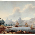
Captain James Cook
Print of James Cook, famous circumnavigator who explored and mapped the Pacific Ocean. The Mariners' Museum 1938.0345.000001
Introduction Captain James Cook is known for his extensive voyages that took him throughout the Pacific. He mapped several island groups in the Pacific that had been previously discovered by other explorers. But he was the first European we know of to encounter the Hawaiian Islands. While on these voyages, Cook discovered that New Zealand was an island. He would go on to discover and chart coastlines from the Arctic to the Antarctic, east coast of Australia to the west coast of North America plus the hundreds of islands in between.
Biography Early Life James Cook was born on October 27, 1728 in the village Marton-in-Cleveland in Yorkshire, England. He was the second son of James Senior and Grace Cook. His father worked as a farm laborer. Young James attended school where he showed a gift for math. 1 But despite having a decent education, James also wound up working as a farm laborer, like his father. At 16, Cook became an apprentice of William Sanderson, a shopkeeper in the small coastal town Staithes. James worked here for almost 2 years before leaving to seek other ventures. He then became a seaman apprentice for John Walker, a shipowner and mariner, in the port of Whitby. Here, Cook developed his navigational skills and continued his studies. Cook worked for Walker’s coal shipping business and worked his way up in rank. He completed his three-year apprenticeship in April 1750, then went on to volunteer for the Royal Navy. He would soon have the opportunity to explore and learn more about seafaring. He was assigned to serve on the HMS Eagle where he was quickly promoted to the position of captain’s mate due to his experience and skills. In 1757, he was transferred to the Pembroke and sent to Nova Scotia, Canada to fight in the Seven Years’ War.
Cook continued to expand his maritime knowledge and skills by learning chart-making. He helped to chart and survey the St. Lawrence River and surrounding areas while in Canada. His charts were published in England while he was abroad. After the war, between 1763 and 1767, Cook commanded the HMS Grenville , and mapped Newfoundland and Labrador’s coastlines. These maps were considered the most detailed and accurate maps of the area in the 18th century. After spending 4 years mapping coastlines in northeast North America, Cook was called back to London by the Royal Society. The Royal Society sent Cook to observe an event known as the transit of Venus. During a transit of Venus, Venus passes between the Earth and the Sun and appears to be a small black circle traveling in front of the Sun. By observing this event, they believed they could calculate the Earth’s distance from the Sun. In May 1768, Cook was chosen by the Society and promoted to lieutenant to lead an expedition to Tahiti, then known as King George’s Island, to observe the transit of Venus. 2 This begin the first of several voyages that would earn James Cook great fame and recognition.
Voyages Principal Voyage James Cook sailed from Deptford, England on July 30, 1768 on his ship Endeavour with a crew of 84 men. 3 The crew included several scientists and artists to record their observations and discoveries during the journey. They made many small stops at different locations along the way. In January 1769, they rounded the tip of South America, and finally reached Tahiti in April 1769. They established a base for their research that they named Fort Venus. On June 3, 1769, Cook and his men successfully observed the transit of Venus. While on the island, they collected samples of the native plants and animals. They also interacted with some native people, learning more about their customs and traditions. Cook sailed to some of the neighboring islands, including modern day Bora Bora, mapping along the way. After completing the observation of Venus’ transit, Cook was given new orders to sail south, search for the Southern Continent – known today as Australia. On August 9, 1769, the Endeavour departed from Tahiti in search of the Southern Continent. After sailing for several weeks with no sign of land, Cook decided to sail west. On October 6th, land was sighted, and Cook and his men made landfall in modern day New Zealand.
Cook named the place Poverty Bay. They were met by unfriendly natives, so Cook decided to sail south along the coast of this new land. He named several islands and bays along the way, such as Bare Island and Cape Turnagain. At Cape Turnagain, the Endeavour turned around and sailed north along the coastline again and rounded the northernmost tip of the island. They sailed down along the western coast Cook and his men crossed a strait to return to Cape Turnagain, thus completing a circumnavigation of the northern island. This trip proved that New Zealand was made up of two separate islands. The expedition then sailed south along the eastern coastline of the southern island. They stopped at Admiralty Bay on the northern coast to resupply before sailing west into open ocean. In April of 1770, Cook first spotted the northeastern coastline of modern day Australia. He landed in Botany Bay near modern day Sydney. 4 He explored some of the area and coastline including places such as Port Jackson and Cape Byron. The Endeavour then sailed around the northernmost tip of the continent before setting sail east back to England. They soon landed in Batavia, now known as Jakarta, in Indonesia. In Batavia, several of the crew, including James Cook became ill, many dying from diseases. 5 The expedition eventually sailed onward, and reached London on July 13, 1771.
Subsequent Voyages In 1772, Cook was promoted to captain. He was given command of the two ships, the Resolution and Adventure , to look for the Southern Continent. On July 13, 1772, the expedition left England, stopping at the Cape of Good Hope to resupply before sailing south. May 26, 1773, Cook and his crew reached Dusky Bay, New Zealand . They spent the winter anchored in Ship Cove, exploring inland and interacting with the Maori natives. When they departed from New Zealand in October of 1773, the two ships became separated and never reunited. 6 The Adventure returned to England. Cook and the Resolution continued onward exploring various islands throughout the Pacific. While sailing in the Pacific, the Resolution crossed into the Antarctic Circle several times sailing farther south than any other explorer at the time. Several times they got stuck in sea ice. So Cook decided to suspend the search for the Southern Continent. But they did not return to England just yet. They sailed to Easter Island and stayed there for seven months, exploring and mapping the nearby Society Islands and the Friendly Islands. November 10, 1774, the Resolution began its return journey to England.They traveled around the tip of South America and stopped briefly on the Sandwich Islands to claim them for England. Cook finally returned to England on July 30, 1775 and reported that there was no Southern Continent to be found.
Just one year later, Cook was given the Resolution and Discovery to lead yet an expedition to search for the Northwest Passage. The ships left England on July 12, 1776. A storm forced them to stop at Adventure Cove in Tasmania before continuing on to Ship Cove. In December of 1777 the men landed at Christmas Island, now known as Kiritimati. Several weeks later, they made a significant discovery when they came upon the islands of Hawaii. They landed at modern day Kauai and were fascinated by the environment and friendly natives. But Cook still wanted to discover the Northwest Passage so they left two weeks laters. They finally landed at modern day Vancouver Island where they interacted and traded with the native people. Cook continued his search for the Northwest Passage and commanded the expedition to sail northwest along the coastline of what is now Alaska, and throughout Prince William Sound. On August 9th, they reached the westernmost point of Alaska, which Cook named Cape Prince of Wales. From here, Cook sailed farther into the Arctic Circle until he was stopped by a thick wall of ice. Cook named this point Icy Cape. Cook and his men sailed back down the coast of Alaska and back south until they reached the Hawaiian Islands again.
Later Years and Death When first landing in Kealakekua Bay, they were met with angry natives. Cook soon met with the Hawaiian ruler, King Kalei’opu’u. It was a friendly meeting, was given large amounts of food and resources.They left Kealakekua Bay on February 4, 1779 but were forced to return a few days later after the Resolution was damaged in a storm. Once more, they were not greeted with joy by the natives. While the Resolution was being repaired, the crew noticed that the natives were stealing their supplies and tools. On February 14th, Cook attempted to stop the thievery by taking Chief Kalei’opu’u hostage. 7 However, fighting between the crew and native people had already started. When Cook attempted to return to his ship, he was attacked on the shoreline. He was beaten with stones and clubs and stabbed in the back of the neck. Cook died on the shore and his body was left behind as the other men returned to the ship. After making peace with the natives a few days later, pieces of Cook’s body were recovered and buried on February 22, 1779. The next day, the remaining crew left Hawaii to return to England. The ships arrived in England on October 4, 1780 after attempting to search for the Northwest Passage one more time.
Legacy Captain James Cook is known for his incredible voyages that took him farther south than any other explorer of his time. He was not able to prove that a southern continent existed, but he had many other achievements. He was the first to map the coastlines of New Zealand, the eastern coastline of what would become Australia, and several small islands in the Pacific. Cook was also one of the first Europeans to encounter the Hawaiian Islands. His reports on Botany Bay were part of the reason Britain established a penal colony there in 1787. 8 He is still recognized today for creating some of the most accurate maps of the Pacific islands during his time. James Cook helped the south seas go from being a vast and dangerous unknown area to a charted and inviting ocean.
- Charles J. Shields, James Cook and the Exploration of the Pacific (Philadelphia: Chelsea House Publishers, 2002), 16.
- Richard Hough, Captain James Cook (New York: WW Norton & Co., 1997) 38-39.
- James Cook, The Voyages of Captain Cook, ed. Ernest Rhys (Hertfordshire: Wordsworth Editions Limited, 1999), 11
- Captain James Cook and Robert Welsch, Voyages of Discovery (Chicago: Academy Chicago Publishers, 1993), v.
- Cook and Welsch, Voyages of Discovery , 102-106.
- Cook, The Voyages of Captain Cook , xiv.
- Charles J. Shields, James Cook and the Exploration of the Pacific , 56.
- Cook and Welsch, Voyages of Discovery , v.
Bibliography
Shields, Charles J. James Cook and the Exploration of the Pacific . Philadelphia: Chelsea House Publishers, 2002.
Hough, Richard. Captain James Cook . New York: WW Norton & Co., 1997.
Cook, James. The Voyages of Captain Cook , edited by Ernest Rhys. Hertfordshire: Wordsworth Editions Limited, 1999.
Cook, Captain James, and Robert Welsch. Voyages of Discovery. Chicago: Academy Chicago Publishers, 1993.
- Original "EXPLORATION through the AGES" site
- The Mariners' Educational Programs

British navigator James Cook charted New Zealand and Australia's Great Barrier Reef on his ship HMB Endeavour and later disproved the existence of the fabled southern continent Terra Australis.

(1728-1779)
Who Was James Cook?
James Cook was a naval captain, navigator and explorer who, in 1770, charted New Zealand and the Great Barrier Reef of Australia on his ship HMB Endeavour. He later disproved the existence of Terra Australis, a fabled southern continent. Cook's voyages helped guide generations of explorers and provided the first accurate map of the Pacific.
Early Life and Career
Cook was born in Marton-in-Cleveland, Yorkshire, England, on October 27, 1728, the son of a Scottish farmhand. As a teenager, Cook did farming work alongside his father until the age of 18 when he was offered an apprenticeship by a Quaker shipowner in a small seaside village near Whitby, England. The experience proved to be fortuitous for the future naval officer and explorer, bringing him in contact with both the ocean and ships along the port.
Naval Officer, Navigator and Explorer
After his return to England, Cook was chosen to circumnavigate and explore Antarctica. On this voyage, he charted present-day Tonga, Easter Island, New Caledonia, the South Sandwich Islands and South Georgia, and disproved the existence of Terra Australis, a fabled southern continent. Cook named the Hawaiian Islands the Sandwich Islands after the Earl of Sandwich, also known as John Montagu.
Later Years, Death and Legacy
During all his voyages, Cook successfully fought scurvy, a deadly disease caused by vitamin deficiency, by feeding his crew a diet that included watercress, sauerkraut and orange extract. He died in a skirmish with islanders during a winter layover in Kealakekua Bay, Hawaii, on February 14, 1779.
Today, Cook's voyages are credited with helping to guide generations of explorers and with providing the first accurate map of the Pacific, and many believe that he did more to fill the map of the world than any other explorer in history.
QUICK FACTS
- Name: James Cook
- Birth Year: 1728
- Birth date: October 27, 1728
- Birth City: Marton-in-Cleveland, Yorkshire, England
- Birth Country: United Kingdom
- Gender: Male
- Best Known For: British navigator James Cook charted New Zealand and Australia's Great Barrier Reef on his ship HMB Endeavour and later disproved the existence of the fabled southern continent Terra Australis.
- War and Militaries
- Astrological Sign: Scorpio
- Death Year: 1779
- Death date: February 14, 1779
- Death State: Hawaii
- Death City: Kealakekua Bay
- Death Country: United States
We strive for accuracy and fairness. If you see something that doesn't look right, contact us !
Famous British People

Mick Jagger

Agatha Christie
")
Alexander McQueen

The Real Royal Scheme Depicted in ‘Mary & George’

William Shakespeare

Anya Taylor-Joy

Kate Middleton, Princess of Wales

Kensington Palace Shares an Update on Kate

Amy Winehouse

Prince William

Where in the World Is Kate Middleton?
Captain James Cook
The Geographic Adventures of Captain Cook, 1728–1779
imamember / E+ / Getty Images
- Key Figures & Milestones
- Physical Geography
- Political Geography
- Country Information
- Urban Geography
- M.A., Geography, California State University - Northridge
- B.A., Geography, University of California - Davis
James Cook was born in 1728 in Marton, England. His father was a Scottish migrant farmworker who allowed James to apprentice on coal-carrying boats at the age of eighteen. While working in the North Sea, Cook spent his free time learning math and navigation. This led to his appointment as mate.
Searching for something more adventurous, in 1755 he volunteered for the British Royal Navy and took part in the Seven Years War and was an instrumental part of the surveying of the St. Lawrence River, which helped in the capture of Quebec from the French.
Cook's First Voyage
Following the war, Cook's skill at navigation and interest in astronomy made him the perfect candidate to lead an expedition planned by the Royal Society and Royal Navy to Tahiti to observe the infrequent passage of Venus across the face of the sun. Precise measurements of this event were needed worldwide to determine the accurate distance between the earth and the sun.
Cook set sail from England in August 1768 on the Endeavor. His first stop was Rio de Janeiro , then the Endeavor proceeded west to Tahiti where camp was established and the transit of Venus was measured. After the stop in Tahiti, Cook had orders to explore and claim possessions for Britain. He charted New Zealand and the east coast of Australia (known as New Holland at the time).
From there he proceeded to the East Indies (Indonesia) and across the Indian Ocean to the Cape of Good Hope at the southern tip of Africa. It was an easy voyage between Africa and home; arriving in July 1771.
Cook's Second Voyage
The Royal Navy promoted James Cook to Captain following his return and had a new mission for him, to find Terra Australis Incognita, the unknown southern land. In the 18th century, it was believed that there was much more land south of the equator than had already been discovered. Cook's first voyage did not disprove claims of a huge landmass near the South Pole between New Zealand and South America.
Two ships, the Resolution and the Adventure left in July 1772 and headed to Cape Town just in time for the southern summer. Captain James Cook proceeded south from Africa and turned around after encountering large amounts of floating pack ice (he came within 75 miles of Antarctica). He then sailed to New Zealand for the winter and in summer proceeded south again past the Antarctic Circle (66.5° South). By circumnavigating the southern waters around Antarctica, he indisputably determined that there was no habitable southern continent. During this voyage, he also discovered several island chains in the Pacific Ocean .
After Captain Cook arrived back in Britain in July 1775, he was elected a Fellow of the Royal Society and received their highest honor for his geographic exploration. Soon Cook's skills would again be put to use.
Cook's Third Voyage
The Navy wanted Cook to determine if there was a Northwest Passage , a mythical waterway that would allow sailing between Europe and Asia across the top of North America. Cook set out in July of 1776 and rounded the southern tip of Africa and headed east across the Indian Ocean . He passed between the North and South islands of New Zealand (through Cook Strait) and towards the coast of North America. He sailed along the coast of what would become Oregon, British Columbia , and Alaska and proceeded through the Bering Strait. His navigation of the Bering Sea was halted by the impassible Arctic ice.
Upon yet again discovering that something did not exist, he continued his voyage. Captain James Cook's last stop was in February 1779 at the Sandwich Islands (Hawaii) where he was killed in a fight with islanders over the theft of a boat.
Cook's explorations dramatically increased European knowledge of the world. As a ship captain and skilled cartographer, he filled in many gaps on world maps. His contributions to eighteenth-century science helped propel further exploration and discovery for many generations.
- Biography of William Bligh, Captain of the HMS Bounty
- Royal Navy: Mutiny on the Bounty
- Charles Darwin and His Voyage Aboard H.M.S. Beagle
- A Brief History of the Age of Exploration
- Biography and Legacy of Ferdinand Magellan
- Biography of Mungo Park
- Biography of Explorer Cheng Ho
- An Overview of the History and Geography of New Zealand
- Amerigo Vespucci, Explorer and Navigator
- Profile of Prince Henry the Navigator
- Biography of Juan Sebastián Elcano, Magellan's Replacement
- The Seven Voyages of the Treasure Fleet
- Pirate Crew: Positions and Duties
- Blank US Maps
- Geography of Australia
- Royal Navy: Admiral Richard Howe, 1st Earl Howe
Captain Cook’s 1768 Voyage to the South Pacific Included a Secret Mission
The explorer traveled to Tahiti under the auspices of science 250 years ago, but his secret orders were to continue Britain’s colonial project
/https://tf-cmsv2-smithsonianmag-media.s3.amazonaws.com/accounts/headshot/lorraine.png "how did james cook travel")
Lorraine Boissoneault
/https://tf-cmsv2-smithsonianmag-media.s3.amazonaws.com/filer/26/64/2664d6d3-014a-44a5-8058-cdad709bacca/captainjamescookportrait.jpg "how did james cook travel")
It was 1768, and the European battle for dominance of the oceans was on. Britain, France, Spain, Portugal and the Netherlands had already spent several centuries traversing the globe in search of new land to conquer and resources to exploit, but the Pacific—and specifically, the South Seas—remained largely unknown. In their race to be the first to lay claim to new territory, the British government and the Royal Navy came up with a secret plan: Send a naval officer on a supposedly scientific voyage, then direct him to undertake a voyage of conquest for the fabled Southern Continent. The man chosen for the job was one James Cook, a Navy captain who also had training in cartography and other sciences.
Europeans already knew the Pacific had its share of islands, and some of them held the potential for enormous wealth. After all, Ferdinand Magellan became the first European to cross the Pacific Ocean way back in 1519, and by then it was already known that the “Spice Islands,” (in modern-day Indonesia) were located in the Pacific. Magellan was followed by a dozen other Europeans—especially Dutch and Spanish captains—over the next two centuries, some of them sighting the western shores of Australia, others identifying New Zealand. But the vastness of the Pacific Ocean, combined with the unreliability of maps, meant no one was sure whether the Southern Continent existed or had been discovered.
Even among the British, Cook wasn’t the first to set his sights on the South Pacific. Just a year earlier, Captain Samuel Wallis piloted the ship Dolphin to make first landing on Tahiti, which he christened George III Island. As for the British government, they had publicized their interest in the region since 1745, when Parliament passed an act offering any British subject a reward of £20,000 if they found the fabled northwest passage from Hudson Bay in North America to the Pacific. The British government wasn’t alone in its imperialist interests; the Dutch explorer Abel Tasman had already sighted an island off the south coast of Australia that would later be named after Tasmania him, and the Spanish had built fortifications on the Juan Fernández Islands off the west coast of Chile.
“For the Spaniards to fortify and garrison Juan Fernández meant that they intended to try to keep the Pacific closed,” writes historian J. Holland Rose . “The British Admiralty was resolved to break down the Spanish claim.”
But to do so without drawing undue attention to their goals, the Admiralty needed another reason to send ships to the Pacific. The Royal Society presented the perfect opportunity for just such a ruse. Founded in 1660 , the scientific group was at first little more than a collection of gentlemen with the inclination and resources to undertake scientific projects. As historian Andrew S. Cook (no apparent relation) writes , “The Society was in essence a useful vehicle for government to utilize the scientific interests of individual fellows, and for fellows to turn their scientific interests into formal applications for government assistance.” When the Royal Society approached the Navy, requesting they send a ship to Tahiti to observe the transit of Venus that would occur in 1769, it probably seemed like the perfect cover, Cook the scholar says.

The 1769 transit of Venus was the mid-18th-century version of the mania surrounding last year’s solar eclipse. It was one of the most massive international undertakings to date. Captain Cook’s crew, complete with astronomers, illustrators and botanists, was one of 76 European expeditions sent to different points around the globe to observe Venus crossing the sun. Scientists hoped that these measurements would help them quantify Earth’s distance from the sun and extrapolate the size of the solar system. The rare event was deemed so important that the French government, fresh off fighting the Seven Years’ War (French and Indian War) with England, issued an instruction to its war ships not to harass Cook. It wasn’t an undue precaution; French astronomer Guillaume Le Gentil traveled to India to observe the 1761 transit of Venus but ultimately missed the event because his ship had to outrun English men-of-wars, according to historian Charles Herdendorf .
Captaining the Endeavour , Cook departed from Plymouth 250 years ago on August 26, 1768, in order to arrive in Tahiti on time for the transit, which would happen on June 3, 1769. His path carried him across the Atlantic and around the difficult-to-traverse Cape Horn in South America toward the south Pacific. He carried with him sealed secret instructions from the Admiralty, which he’d been ordered not to open until after completing the astronomical work. Unfortunately for the scientists, the actual observations of the transit at points around the world were mostly useless. Telescopes of the period caused blurring around the planet that skewed the recorded timing of Venus passing across the sun.
But for Cook, the adventure was just beginning. “Cook left no record of when he opened the sealed packet of secret orders he’d been given by the Admiralty,” writes Tony Horwitz in Blue Latitudes: Boldly Going Where Captain Cook Has Gone Before . “But on August 9, 1769, as he left Bora-Bora and the other Society Isles behind, Cook put his instructions into action. ‘Made sail to the southward,’ he wrote, with customary brevity.”
The gist of those instructions was for Cook to travel south and west in search of new land—especially the legendary “Terra Australis,” an unknown continent first proposed by Greek philosophers like Aristotle, who believed a large southern continent was needed to balance out the weight of northern continents. In their instructions, the Royal Navy told Cook not only to map the coastline of any new land, but also “to observe the genius, temper, disposition and number of the natives, if there be any, and endeavor by all proper means to cultivate a friendship and alliance with them… You are also with the consent of the natives to take possession of convenient situations in the country, in the name of the King of Great Britain.”
Cook went on to follow those instructions over the next year, spending a total of 1,052 days at sea on this mission. He became the first European to circumnavigate and meticulously chart the coastline of New Zealand’s two islands, and repeatedly made contact with the indigenous Maori living there. He also traveled along the east coast of Australia, again becoming the first European to do so. By the time he and his crew (those who survived, anyway) returned to England in 1771, they had expanded the British Empire’s reach to an almost incomprehensible degree. But he hadn’t always followed his secret instructions exactly as they were written—he took possession of those new territories without the consent of its inhabitants, and continued to do so on his next two expeditions.

Even as he took control of their land, Cook seemed to recognize the indigenous groups as actual humans. On his first trip to New Zealand, he wrote , “The Natives … are a strong, well made, active people as any we have seen yet, and all of them paint their bod[ie]s with red oker and oil from head to foot, a thing we have not seen before. Their canoes are large, well built and ornamented with carved work.”
“It would be as wrong to regard Cook as an unwitting agent of British imperialism as [it would be] to fall into the trap of ‘judging him according to how we judge what happened afterwards,’” writes Glyndwr Williams . “His command of successive voyages indicated both his professional commitment, and his patriotic belief that if a European nation should dominate the waters and lands of the Pacific, then it must be Britain.”
But the toll of that decision would be heavy. Cook estimated the native population on Tahiti to be 204,000 in 1774. By the time the French took control of the territory and held a census in 1865, they found only 7,169 people of native descent . And as for the British Empire, the 1871 census found 234 million people lived in it—but only 13 percent were in Great Britain and Ireland, writes Jessica Ratcliff in The Transit of Venus Enterprise in Victorian Britain . From the Caribbean and South America to Africa to South Asia to now, thanks to Cook, Australia, the aphorism “the sun never sets on the British Empire” was borne. Cook’s expedition to conquer inhabited territory had repercussions for millions of people who would never actually see the nation who had claimed their homes.
For centuries, the myth of Cook’s voyage as an essentially scientific undertaking persisted, although plenty of people had already surmised the government's hand in Cook's journeys. Still, a full copy of the Admiralty’s “Secret Instructions” weren't made public until 1928. Today, Cook’s legacy is recognized more for what it was: an empire-building project dressed with the trappings of science.
Get the latest History stories in your inbox?
Click to visit our Privacy Statement .
/https://tf-cmsv2-smithsonianmag-media.s3.amazonaws.com/accounts/headshot/lorraine.png "how did james cook travel")
Lorraine Boissoneault | | READ MORE
Lorraine Boissoneault is a contributing writer to SmithsonianMag.com covering history and archaeology. She has previously written for The Atlantic, Salon, Nautilus and others. She is also the author of The Last Voyageurs: Retracing La Salle's Journey Across America. Website: http://www.lboissoneault.com/
James Cook and his voyages
The son of a farm labourer, James Cook (1728–1779) was born at Marton in Yorkshire. In 1747 he was apprenticed to James Walker, a shipowner and master mariner of Whitby, and for several years sailed in colliers in the North Sea, English Channel, Irish Sea and Baltic Sea. In 1755 he volunteered for service in the Royal Navy and was appointed an able seaman on HMS Eagle . Within two years he was promoted to the rank of master and in 1758 he sailed to North America on HMS Pembroke . His surveys of the St Lawrence River, in the weeks before the capture of Quebec, established his reputation as an outstanding surveyor. In 1763 the Admiralty gave him the task of surveying the coast of Newfoundland and southern Labrador. He spent four years on HMS Grenville , recording harbours and headlands, shoals and rocks, and also observed an eclipse of the sun in 1766.
First voyage
In May 1768 Cook was promoted to the rank of lieutenant and given command of the bark Endeavour . He was instructed to sail to Tahiti to observe the transit of Venus in 1769 and also to ascertain whether a continent existed in the southern latitudes of the Pacific Ocean. The expedition, which included a party of scientists and artists led by Joseph Banks, left Plymouth in August 1768 and sailed to Brazil and around Cape Horn, reaching Tahiti in April 1769. After the astronomical observations were completed, Cook sailed south to 40°S, but failed to find any land. He then headed for New Zealand, which he circumnavigated, establishing that there were two principal islands. From New Zealand he sailed to New Holland, which he first sighted in April 1770. He charted the eastern coast, naming prominent landmarks and collecting many botanical specimens at Botany Bay. The expedition nearly ended in disaster when the Endeavour struck the Great Barrier Reef, but it was eventually dislodged and was careened and repaired at Endeavour River. From there it sailed around Cape York through Torres Strait to Batavia, in the Dutch East Indies. In Batavia and on the last leg of the voyage one-third of the crew died of malaria and dysentery. Cook and the other survivors finally reached England in July 1771.
Second voyage
In 1772 Cook, who had been promoted to the rank of captain, led a new expedition to settle once and for all the speculative existence of the Great Southern Continent by ‘prosecuting your discoveries as near to the South Pole as possible’. The sloops Resolution and Adventure , the latter commanded by Tobias Furneaux, left Sheerness in June 1772 and sailed to Cape Town. The ships became separated in the southern Indian Ocean and the Adventure sailed along the southern and eastern coasts of Van Diemen’s Land before reuniting with the Resolution at Queen Charlotte Sound in New Zealand. The ships explored the Society and Friendly Islands before they again became separated in October 1773. The Adventure sailed to New Zealand, where 10 of the crew were killed by Maori, and returned to England in June 1774. The Resolution sailed south from New Zealand, crossing the Antarctic Circle and reaching 71°10’S, further south than any ship had been before. It then traversed the southern Pacific Ocean, visiting Easter Island, Tahiti, the Friendly Islands, New Hebrides, New Caledonia, Norfolk Island and New Zealand. In November 1774 Cook began the homeward voyage, sailing to Chile, Patagonia, Tierra del Fuego, South Georgia and Cape Town. The expedition reached England in July 1775.
Third voyage
A year later Cook left Plymouth on an expedition to search for the North West Passage. His two ships were HMS Resolution and Discovery , the latter commanded by Charles Clerke. They sailed to Cape Town, Kerguelen Island in the southern Indian Ocean, Adventure Bay in Van Diemen’s Land, and Queen Charlotte Sound in New Zealand. They then revisited the Friendly and Society Islands. Sailing northwards, Cook became the first European to travel to the Hawaiian Islands (which he named the Sandwich Islands), and reached the North American coast in March 1778. The ships followed the coast northwards to Alaska and the Bering Strait and reached 70°44’N, before being driven back by ice. They returned to the Sandwich Islands and on 14 February 1779 Cook was killed by Hawaiians at Kealakekua Bay. Clerke took over the command and in the summer of 1779 the expedition again tried unsuccessfully to penetrate the pack ice beyond Bering Strait. Clerke died in August 1779 and John Gore and James King commanded the ships on the voyage home via Macao and Cape Town. They reached London in October 1780.
Acquisition
The earliest acquisitions by the Library of original works concerning Cook’s voyages were the papers of Sir Joseph Banks and a painting of John Webber, which were acquired from E.A. Petherick in 1909. In 1923 the Australian Government purchased at a Sotheby’s sale in London the Endeavour journal of James Cook, together with four other Cook documents that had been in the possession of the Bolckow family in Yorkshire. The manuscripts of Alexander Home were purchased from the Museum Bookstore in London in 1925, while the journal of James Burney was received with the Ferguson Collection in 1970. A facsimile copy of the journal of the Resolution in 1772–75 was presented by Queen Elizabeth II in 1954.
The 18 crayon drawings of South Sea Islanders by William Hodges were presented to the Library by the British Admiralty in 1939. They had previously been in the possession of Greenwich Hospital. The view from Point Venus by Hodges was bought at a Christie’s sale in 1979. The paintings of William Ellis were part of the Nan Kivell Collection, with the exception of the view of Adventure Bay, which was bought from Hordern House in Sydney in 1993. The painting of the death of Cook by George Carter and most of the paintings of John Webber were also acquired from Rex Nan Kivell. The painting by John Mortimer was bequeathed to the Library by Dame Merlyn Myer and was received in 1987.
Description
Manuscripts.
The Endeavour journal of James Cook (MS 1) is the most famous item in the Library’s collections. It has been the centrepiece of many exhibitions ever since its acquisition in 1923, and in 2001 it became the first Australian item to be included on the United Nations Educational, Scientific and Cultural Organization’s (UNESCO’s) Memory of the World Register. While there are other journals of the first voyage that are partly in Cook’s hand, MS 1 is the only journal that is entirely written by Cook and covers the whole voyage of the Endeavour . The early entries in 1768, as the ship crossed the Atlantic Ocean, are brief but the passages describing Cook’s experiences and impressions in Tahiti, New Zealand and New South Wales in 1769–70 are very detailed. The journal, which is 753 pages in length, was originally a series of paper volumes and loose sheets, but they were bound into a single volume in the late nineteenth century. The current binding of oak and pigskin dates from 1976.
Two other manuscripts, also acquired in 1923, relate to the first voyage. The Endeavour letterbook (MS 2), in the hand of Cook’s clerk, Richard Orton, contains copies of Cook’s correspondence with the Admiralty and the various branches of the Navy Board. Of particular importance are the original and additional secret instructions that he received from the Lords of the Admiralty in July 1768. The other item (MS 3) is a log of the voyage, ending with the arrival in Batavia. The writer is not known, although it may have been Charles Green, the astronomer. Other documents concerning the voyage are among the papers of Joseph Banks (MS 9), including his letters to the Viceroy of Brazil in 1768 and the ‘Hints’ of the Earl of Morton, the president of the Royal Society.
The Library holds a facsimile copy (MS 1153) of the journal of HMS Resolution on the second voyage, the original of which is in the National Maritime Museum in London. It is in the hand of Cook’s clerk, William Dawson. It also holds the journal (MS 3244) of James Burney, a midshipman on HMS Adventure , covering the first part of the voyage in 1772–73. It includes a map of eastern Van Diemen’s Land and Burney’s transcription of Tongan music. In addition, there is a letterbook (MS 6) of the Resolution for both the second and third voyages. Documents of the third voyage include an account of the death of Cook (MS 8), probably dictated by Burney, and two manuscripts of Alexander Home (MS 690). They contain descriptions of Tahiti and Kamtschatka and another account of Cook’s death.
The earliest manuscript of Cook in the collection is his description of the coast of Nova Scotia, with two maps of Harbour Grace and Carbonere, dating from 1762 (MS 5). The Library holds original letters of Cook written to John Harrison, George Perry, Sir Philip Stephens and the Commissioners of Victualling. There is also in the Nan Kivell Collection a group of papers and letters of the Cook family, 1776–1926 (MS 4263).
MS 1 Journal of the H.M.S. Endeavour, 1768-1771
MS 2 Cook's voyage 1768-71 : copies of correspondence, etc. 1768-1771
MS 3 Log of H.M.S. Endeavour, 1768-1770
MS 5 Description of the sea coast of Nova Scotia, 1762
MS 6 Letterbook, 1771-1778
MS 8 Account of the death of James Cook, 1779
MS 9 Papers of Sir Joseph Banks, 1745-1923
MS 690 Home, Alexander, Journals, 1777-1779
MS 1153 Journal of H.M.S. Resolution, 1772-1775
MS 3244 Burney, James, Journal, 1772-1773
MS 4263 Family papers 1776-1926
Many records relating to the voyages of Cook have been microfilmed at the National Archives (formerly the Public Record Office) in London and other archives and libraries in Britain. They include the official log of HMS Endeavour and the private journals kept by Cook on his second and third voyages. The reels with the prefixes PRO or M were filmed by the Australian Joint Copying Project.
mfm PRO 3268 Letters of Capt. James Cook to the Admiralty, 1768–79 (Adm. 1/1609-12)
mfm PRO 1550–51 Captain’s log books, HMS Adventure , 1772–74 (Adm. 51/4521-24)
mfm PRO 1554 Captain’s log books, HMS Discovery , 1776–79 (Adm. 51/ 4528-9)
mfm PRO 1554 Captain’s log books, HMS Resolution , 1779 (Adm. 51/4529)
mfm PRO 1555–6 Captain’s log books, HMS Discovery , 1776–79 (Adm. 51/4530-1)
mfm PRO 1561–3 Captain’s log books, HMS Endeavour , 1768–71 (Adm. 51/4545-8)
mfm PRO 1565–70 Captain’s log books, HMS Resolution , 1771–79 (Adm. 51/4553-61)
mfm PRO 1572 Logbooks, HMS Adventure , 1772–74 (Adm. 53/1)
mfm PRO 1575–6 Logbooks, HMS Discovery , 1776–79 (Adm. 53/20-24)
mfm PRO 1580 Logbooks, HMS Endeavour , 1768–71 (Adm. 53/39-41)
mfm PRO 1590–4 Logbooks, HMS Resolution , 1771–80 (Adm. 53/103-24)
mfm PRO 1756 Logbook, HMS Adventure , 1772–74 (BL 44)
mfm PRO 1756 Observations made on board HMS Adventure , 1772–74 (BL 45)
mfm PRO 1756A Logbook, HMS Resolution , 1772–75 (BL 46)
mfm PRO 1756 Observations made on board HMS Resolution , 1772–75 (BL 47)
mfm PRO 1756 Journal of Capt. J. Cook: observations on variations in compass and chronometer rates, 1776 (BL 48)
mfm PRO 1756 Astronomical observations, HMS Resolution , 1778–80 (BL 49)
mfm PRO 4461–2 Ship’s musters, HMS Endeavour , 1768–71 (Adm. 12/8569)
mfm PRO 4462–3 Ship’s musters, HMS Adventure , 1769–74 (Adm. 12/7550)
mfm PRO 4463–4 Ship’s musters, HMS Resolution , 1771–75 (Adm. 12/7672)
mfm PRO 4464 Ship’s musters, HMS Discovery , 1776–80 (Adm. 12/8013)
mfm PRO 4464–5 Ship’s musters, HMS Resolution , 1776–80 (Adm. 12/9048-9)
mfm PRO 6119 Deptford Yard letterbooks, 1765-78 (Adm. 106/3315-8)
MAP mfm M 406 Charts and tracings of Australian and New Zealand coastlines by R. Pickersgill and Capt. James Cook, 1769–70 (Hydrographic Department)
mfm M 869 Letters of David Samwell, 1773–82 (Liverpool City Libraries)
mfm M 1561 Log of HMS Endeavour , 1768–71 (British Library)
mfm M 1562 Journal of Capt. Tobias Furneaux on HMS Adventure , 1772–74 (British Library)
mfm M1563 Drawings of William Hodges on voyage of HMS Resolution , 1772–74 (British Library)
mfm M 1564 Log of Lieut. Charles Clerke on HMS Resolution , 1772–75 (British Library)
mfm M 1565 Journal of Lieut. James Burney on HMS Discovery , 1776–79 (British Library)
mfm M 1566 Journal of Thomas Edgar on HMS Discovery , 1776–79
mfm M 1580 Journal of Capt. James Cook on HMS Resolution , 1771–74 (British Library)
mfm M 1580–1 Journal of Capt. James Cook on HMS Resolution , 1776–79 (British Library)
mfm M 1583 Journal of David Samwell on HMS Resolution and Discovery , 1776–79 (British Library)
mfm M 2662 Correspondence of Sir Joseph Banks, 1768–1819 (Natural History Museum)
mfm M 3038 Letters of Capt. James Cook, 1775–77 (National Maritime Museum)
mfm M 3074 Drafts of Capt. James Cook’s account of his second voyage (National Maritime Museum)
mfm G 9 Journal of voyage of HMS Endeavour , 1768–71 (National Maritime Museum)
mfm G 13 Journal of voyage of HMS Resolution , 1772–75 (National Maritime Museum)
mfm G 27412 Journal of Capt. James Cook on HMS Endeavour , 1768–70 (Mitchell Library)
The only manuscript maps drawn by Cook held in the Library are the two maps of Halifax Harbour, Nova Scotia, contained in MS 5. The map by James Burney of Van Diemen’s Land, contained in his 1773–74 journal, is the only manuscript map in the Library emanating from Cook’s three Pacific voyages.
On the first voyage most of the surveys were carried out by Cook himself, assisted by Robert Molyneux, the master, and Richard Pickersgill, the master’s mate. Cook produced some of the fair charts, but it seems that most were drawn by Isaac Smith, one of the midshipmen. After the voyage the larger charts were engraved by William Whitchurch and a number of engravers worked on the smaller maps. The Library holds nine maps (six sheets) and five coastal views (one sheet) published in 1773, as well as two French maps of New Zealand and New South Wales based on Cook’s discoveries (1774).
Cook and Pickersgill, who had been promoted to lieutenant, carried out most of the surveys on the second voyage. Others were performed by Joseph Gilbert, master of the Resolution , Peter Fannin, master of the Adventure , the astronomer William Wales and James Burney. Isaac Smith, the master’s mate, again drew most of the fair charts of the voyage and William Whitchurch again did most of the engravings. The Library holds 15 maps (10 sheets) published in 1777.
On the third voyage, Cook seems to have produced very few charts. Most of the surveys were carried out by William Bligh, master of the Resolution , and Thomas Edgar, master of the Discovery . Henry Roberts, the master’s mate and a competent artist, made the fair charts and after the voyage he drew the compilation charts from which the engraved plates were produced. Alexander Dalrymple supervised the engravings. The Library holds five maps and five coastal views published in 1784–86.

The Library holds a number of objects that allegedly belonged to Cook, such as a walking stick, a clothes brush and a fork. A more substantial artefact is a mahogany and rosewood fall-front desk that was believed to have been used by Cook on one of his voyages. Other association items are a compass, protractor, ruler and spirit level owned by Alexander Hood, the master’s mate on HMS Resolution in 1772–75.
Three of the medals issued by the Royal Society in 1784 to commemorate the achievements of Cook are held in the Library. Another medal issued in 1823 to commemorate his voyages is also held.
The Library has several collections of tapa cloth, including a piece of cloth and two reed maps brought back by Alexander Hood in 1774 and a catalogue of 56 specimens of cloth collected on Cook’s three voyages (1787).
Captain James Cook's walking stick
Clothes brush said to have been the property of Captain Cook
Captain James Cook's fork
Mahogany fall-front bureau believed to have been used by Captain Cook
Compass, protractor, ruler and spirit level owned by Alexander Hood
Commemorative medal to celebrate the voyages of Captain James Cook (1784)
Medal to commemorate the voyages of Captain Cook (1823)
Sample of tapa cloth and two reed mats brought back by Alex Hood
A catalogue of the different specimens of cloth collected in the three voyages of Captain Cook
The Library holds a very large number of engraved portraits of James Cook, many of them based on the paintings by Nathaniel Dance, William Hodges and John Webber. It also holds two oil portraits by unknown artists, one being a copy of the portrait by Dance held in the National Maritime Museum in London. Of special interest is a large oil painting by John Mortimer, possibly painted in 1771, depicting Daniel Solander, Joseph Banks, James Cook, John Hawkesworth and Lord Sandwich.
There were two artists on the Endeavour : Alexander Buchan, who died in Tahiti in 1769, and Sydney Parkinson, who died in Batavia in 1771. The Library has a few original works that have been attributed to Parkinson, in particular a watercolour of breadfruit, which is in the Nan Kivell Collection. In addition, there are a number of prints that were reproduced in the publications of Hawkesworth and Parkinson in 1773, including the interior of a Tahitian house, the fort at Point Venus, a view of Matavai Bay, Maori warriors and war canoes, mountainous country on the west coast of New Zealand, and a view of Endeavour River.
William Hodges was the artist on the Resolution in 1772–75. The Library holds an outstanding collection of 18 chalk drawings by Hodges of the heads of Pacific Islanders. They depict men and women of New Zealand, Tahiti, Tonga, New Caledonia, New Hebrides and Easter Island. Other works by Hodges include an oil painting of a dodo and a red parakeet, watercolours of Tahiti, Tonga and the New Hebrides, and an oil painting of Point Venus. There are also two pen and wash drawings of the Resolution by John Elliott, who was a midshipman on the ship. Among the prints of Hodges are other heads of Pacific Islanders, a portrait of Omai, the Tahitian who visited England in 1775–76, and views of Tahiti, New Caledonia, New Hebrides, Norfolk Island, Easter Island and Tierra del Fuego.
John Webber, who was on the Resolution in 1776–80, had been trained as a landscape artist in Berne and Paris. Another artist on the expedition was William Ellis, the surgeon’s mate on the Discovery , who was a fine draughtsman. The Library holds 19 of Webber’s watercolours, ink and wash drawings, crayon drawings and pencil drawings of views in Tahiti, the Friendly Islands, the Sandwich Islands, Alaska and Kamchatka. There are also oil portraits by Webber of John Gore and James King. Ellis is equally well represented, with 23 watercolours, ink drawings and pencil drawings of scenes in Kerguelen Island, New Zealand, Tahiti, Nootka Sound, Alaska and Kamchatka. Of particular interest is a watercolour and ink drawing by Ellis of the Resolution and Discovery moored in Adventure Bay in 1777, the earliest original Australian work in the Pictures Collection. The death of Cook is the subject of the largest oil painting in the Library’s collection, painted by George Carter in 1781.
Omai, the first Polynesian to be seen in London, was the subject of a number of portraits, included a celebrated painting by Sir Joshua Reynolds. The Library has a pencil drawing of Omai by Reynolds. A pantomime by John O’Keefe entitled Omai, or a Trip Round the World , enjoyed great success in London in 1785–86, being played more than 50 times. The Library holds a collection of 17 watercolour costume designs for the pantomime, drawn by Philippe de Loutherbourg and based mainly on drawings by Webber. The subjects include ‘Obereyaee enchatress’, ‘Otoo King of Otaheite’, ‘a chief of Tchutzki’ and ‘a Kamtchadale’.
Publications
Bibliography.
Beddie,M.K. (ed.), Bibliography of Captain James Cook, R,N., F.R.S., circumnavigator , Library of New South Wales, Sydney, 1970.
Original Accounts of the Voyages
Hawkesworth, John, An account of the voyages undertaken by the order of His Present Majesty, for making discoveries in the Southern Hemisphere, and successively performed by Commodore Byron, Captain Wallis, Captain Carteret, and Captain Cook, in the Dolphin, the Swallow, and the Endeavour (3 vols, 1773)
Parkinson, Sydney, A journal of the voyage to the South Seas, in His Majesty’s Ship, the Endeavour (1773)
Marra, John, Journal of the Resolution’s Voyage, in 1772, 1773, 1774, and 1775, on Discovery to the Southern Hemisphere (1775)
Cook, James, A voyage towards the South Pole, and round the world: performed in His Majesty’s Ships the Resolution and the Adventure in the years 1772,1773, 1774, and 1775 (2 vols, 1777)
Forster, Georg, A voyage round the world in His Britannic Majesty’s Sloop, Resolution, Commanded by Capt. James Cook, during the years 1772, 3, 4 and 5 (2 vols, 1777)
Wales, William, The original astronomical observations, made in the course of a voyage towards the South Pole, and round the world (1777)
Rickman, John, Journal of Captain Cook’s last voyage to the Pacific Ocean, on discovery: performed in the years 1776, 1777, 1778, and 1779 (1781)
Zimmermann, Heinrich, Heinrich Zimmermanns von Wissloch in der Pfalz, Reise um die Welt, mit Capitain Cook (1781)
Ellis, William, An authentic narrative of a voyage performed by Captain Cook and Captain Clerke, in His Majesty’s ships Resolution and Discovery during the years 1776, 1777, 1778, 1779, and 1780 (2 vols, 1782)
Ledyard, John, Journal of Captain Cook’s last voyage to the Pacific Ocean, and in quest of a North-West Passage Between Asia & America, performed in the years 1776, 1777, 1778 and 1779 (1783)
Cook, James and King, James, A voyage to the Pacific Ocean: undertaken by Command of His Majesty, for making discoveries in the Northern Hemisphere, performed under the direction of Captains Cook, Clerke, and Gore, in the years 1776, 1777, 1778, 1779, and 1780 (4 vols, 1784)
Sparrman, Anders, Reise nach dem Vorgebirge der guten Hoffnung, den sudlischen Polarlandern und um die Welt (1784)
Modern Texts
Beaglehole, J.C. (ed.), The Endeavour journal of Joseph Banks, 1768–1771 (2 vols, 1962)
Beaglehole, J.C. (ed.), The journals of Captain James Cook on his voyages of discovery (4 vols, 1955–74)
David, Andrew (ed.), The charts & coastal Views of Captain Cook’s voyages (3 vols, 1988–97)
Hooper, Beverley (ed.), With Captain James Cook in the Antarctic and Pacific: the private journal of James Burney, Second Lieutenant on the Adventure on Cook’s second voyage, 1772–1773 (1975)
Joppien, Rudiger and Smith, Bernard, The art of Captain Cook’s voyages (3 vols in 4, 1985–87)
Parkin, Ray, H.M. Bark Endeavour: her place in Australian history: with an account of her construction, crew and equipment and a narrative of her voyage on the East Coast of New Holland in 1770 (1997)
Biographical Works and Related Studies
There are a huge number of books and pamphlets on the lives of Cook, Banks and their associates. The following are some of the more substantial works:
Alexander, Michael, Omai, noble savage (1977)
Beaglehole, J.C., The life of Captain James Cook (1974)
Besant, Walter, Captain Cook (1890)
Blainey, Geoffrey, Sea of dangers: Captain Cook and his rivals (2008)
Cameron, Hector, Sir Joseph Banks, K.B., P.R.S.: the autocrat of the philosophers (1952)
Carr, D.J., Sydney Parkinson, artist of Cook’s Endeavour voyage (1983)
Carter, Harold B., Sir Joseph Banks, 1743–1820 (1988)
Collingridge, Vanessa, Captain Cook: obsession and betrayal in the New World (2002)
Connaughton, Richard, Omai, the Prince who never was (2005)
Dugard, Martin, Farther than any man: the rise and fall of Captain James Cook (2001)
Duyker, Edward, Nature’s argonaut: Daniel Solander 1733–1782: naturalist and voyager with Cook and Banks (1998)
Furneaux, Rupert, Tobias Furneaux, circumnavigator (1960)
Gascoigne, John, Captain Cook: voyager between worlds (2007)
Hoare, Michael E., The tactless philosopher: Johann Reinhold Forster (1729–98) (1976)
Hough, Richard, Captain James Cook: a biography (1994)
Kippis, Andrew, The life of Captain James Cook (1788)
Kitson, Arthur, Captain James Cook, RN, FRS, the circumnavigator (1907)
Lyte, Charles, Sir Joseph Banks: 18th Century explorer, botanist and entrepreneur (1980)
McAleer, John and Rigby, Nigel, Captain Cook and the Pacific: art, exploration & empire (2017)
McCormick, E.H., Omai: Pacific envoy (1977)
McLynn, Frank, Captain Cook: master of the seas (2011)
Molony, John N., Captain James Cook: claiming the Great South Land (2016)
Moore, Peter, Endeavour: the ship and the attitude that changed the world (2018)
Mundle, Rob, Cook (2013)
Nugent, Maria, Captain Cook was here (2009)
Obeyesekere, Gananath, The apotheosis of Captain Cook: European mythmaking in the Pacific (1992)
O’Brian, Patrick, Joseph Banks, a life (1987)
Rienits, Rex and Rienits, Thea, The voyages of Captain Cook , 1968)
Robson, John, Captain Cook's war and peace: the Royal Navy years 1755-1768 (2009)
Sahlins, Marshall, How ‘natives’ think: about Captain Cook, for example (1995)
Saine, Thomas P., Georg Forster (1972)
Smith, Edward, The life of Sir Joseph Banks, president of the Royal Society (1911)
Thomas, Nicholas, Cook: The extraordinary voyages of Captain James Cook (2003)
Villiers, Alan, Captain Cook, the seamen’s seaman: a study of the great discoverer (1967).
Organisation
The manuscripts of Cook and his associates are held in the Manuscripts Collection at various locations. They have been catalogued individually. Some of them have been microfilmed, such as the Endeavour journal (mfm G27412), the Endeavour log and letterbook (mfm G3921) and the Resolution letterbook (mfm G3758). The Endeavour journal and letterbook and the papers of Sir Joseph Banks have been digitised and are accessible on the Library’s website. The microfilms have also been catalogued individually and are accessible in the Newspaper and Microcopy Reading Room.
The paintings, drawings, prints and objects are held in the Pictures Collection, while the maps and published coastal views are held in the Maps Collection. They have been catalogued individually and many of them have been digitised.
Biskup, Peter, Captain Cook’s Endeavour Journal and Australian Libraries: A Study in Institutional One-upmanship , Australian Academic and Research Libraries , vol. 18 (3), September 1987, pp. 137–49.
Cook & Omai: The Cult of the South Seas , National Library of Australia, Canberra, 2001.
Dening, Greg, MS 1 Cook, J. Holograph Journal , in Cochrane, Peter (ed.), Remarkable Occurrences: The National Library of Australia’s First 100 Years 1901–2001 , National Library of Australia, Canberra, 2001.
Healy, Annette, The Endeavour Journal 1768–71 , National Library of Australia, Canberra, 1997.
Healy, Annette, ' Charting the voyager of the Endeavour journal ', National Library of Australia News, volume 7(3), December 1996, pp 9-12
Hetherington, Michelle, 'John Hamilton Mortimer and the discovery of Captain Cook', British Art Journal, volume 4 (1), 2003, pp. 69-77
First posted 2008 (revised 2019)
The National Library of Australia acknowledges Australia’s First Nations Peoples – the First Australians – as the Traditional Owners and Custodians of this land and gives respect to the Elders – past and present – and through them to all Australian Aboriginal and Torres Strait Islander people.
Cultural Notification
Australian Aboriginal and Torres Strait Islander people are advised that this website contains a range of material which may be considered culturally sensitive including the records of people who have passed away.
Cook's First Voyage
First voyage of captain james cook.
(1768 - 1771)
James Cook’s first voyage circumnavigated the globe in the ship Endeavour , giving the botanists Joseph Banks and Daniel Solander the opportunity to collect plants from previously unexplored habitats. Although the Endeavour voyage was officially a journey to Tahiti to observe the 1769 transit of Venus across the sun, it also had a more clandestine mission from the Royal Society to explore the South Pacific in the name of England. The two botanists on the expedition returned with a collection of plant specimens including an estimated 100 new families and 1,000 new species of plants, many of which are currently housed in the U. S. National Herbarium.
Joseph Banks, who would later become Sir Joseph Banks and president of the Royal Society, was a wealthy young scientist. He invited his close friend Daniel Solander, a Swedish student of Linnaeus working in the natural history collections of the British Museum, to join him on the Endeavour expedition. Together they acted as the naturalists on the voyage, commanding several servants and artists, including Sydney Parkinson, and outfitted with an excellent array of scientific equipment. After setting out from London, the expedition stopped briefly at Madeira, a small Portuguese island in the Atlantic Ocean, and then continued on to Rio de Janiero, on the eastern coast of Brazil. Here, the expedition encountered one of its first major setbacks when the Portuguese governor Dom Antonio Rolim de Moura Tavare refused to allow anyone from the Endeavour to come on land except to acquire necessities. This restriction, however, didn’t stop the two determined botanists. Banks and Solander risked being arrested as spies or smugglers in order to sneak onshore to collect specimens around the city. Despite this difficulty, the expedition traveled on to Tierra del Fuego at the southern tip of South America, where they collected a large number of specimens despite bitterly cold weather that killed two members of the crew. In April of 1769, the expedition reached Tahiti, where they stayed until July. During this time, Banks and Solander collected over 250 plant species, including the orchids Liparis revoluta and Oberonia equitans (also known as Oberonia disticha ) and the flowering plant Ophiorrhiza solandri , in the first extensive botanical study in Polynesia.
After viewing the transit of Venus on June 3, 1769, the expedition began mapping, exploring, and collecting specimens in the relatively unknown regions of New Zealand and the eastern coast of Australia (then called New Holland). Plants collected included the large orchid Dendrobium cunninghamii , also known as Winika cunninghamii , native to the western shore of New Zealand, as well as white-honeysuckle ( Banksia integrifolia ), native to the east coast of Australia. The Endeavour stopped for nine days at a bay on the coast of Australia, where, according to Banks, the expedition’s plant collection became “so immensely large that it was necessary that some extraordinary care should be taken of them least they should spoil.” The botanists were so successful that Cook decided to name the place Botany Bay in honor of their extensive discoveries.
The Endeavour continued its voyage mapping the eastern coast of Australia, narrowly avoiding shipwreck on the Great Barrier Reef, until it re-entered known waters near New Guinea in late August, 1770. During the last part of the voyage, the Endeavour stopped at the disease-ridden city of Batavia in Java and at the Cape of Good Hope in Africa, returning to England in July, 1771. Overall, the expedition was very successful, with little strife among the crew and no deaths from scurvy. Although neither Banks nor Solander published their botanical findings, the two naturalists returned to England with a vast wealth of new discoveries.
References:
Adams, Brian. The Flowering of the Pacific . Sydney: William Collins Pty, 1986. Allen, Oliver E. The Pacific Navigators . Canada: Time-Life Books, 1980. Global Biodiversity Information Facility (GBIF) database, http://gbif.org/ (for information on plant species Dendrobium cunninghamii ; accessed June 15, 2010). Ebes, Hank. The Florilegium of Captain Cook’s First Voyage to Australia: 1768-1771 . Melbourne: Ebes Douwma Antique Prints and Maps, 1988. Encyclopedia of Life (EOL) database, http://www.eol.org/ (for information on plant species Oberonia disticha and Dendrobium cunninghamii ; accessed June 15, 2010). Merrill, Elmer Drew. The Botany of Cook’s Voyages and its Unexpected Significance in Relation to Anthropology, Biogeography and History . Waltham, Massachusetts: Chronica Botanica Co., 1954. O’Brian, Patrick. Joseph Banks: A Life . Boston: David R. Gardine, Publisher, 1993. Rauchenberg, Roy A. “Daniel Carl Solander: Naturalist on the ‘Endeavour’,” Transactions of the American Philosophical Society , New Series, 58, no. 8 (1968): 1-66. http://www.jstor.org/stable/1006027 (May 26, 2010). National Library of Australia. “South Seas: Voyaging and Cross-Cultural Encounters in the Pacific.” South Seas , n.d. http://southseas.nla.gov.au/ . Contains maps and text of expedition journals by James Cook and Joseph Banks. USDA PLANTS database. United States Department of Agriculture, Natural Resources Conservation Service. National Plant Data Center. http://plants.usda.gov/ (for information on plant species Banksia integrifolia ; accessed June 15, 2010).
- Smithsonian Institution
- Terms of Use
- Privacy Policy
- Host an Event

Captain Cook’s voyages of exploration
Terra Australis Incognita - the unknown southern land. The existence (or not) of this mysterious, mythical place has intrigued philosophers, explorers and map-makers since it was first hypothesised by the ancient Greeks and Romans. The empire-builders of 18th century Britain were just as obsessed with investigating territories below the Equator.
In 1768, when Captain James Cook set sail on the first of three voyages to the South Seas, he carried with him secret orders from the British Admiralty to seek ‘a Continent or Land of great extent’ and to take possession of that country ‘in the Name of the King of Great Britain’.
While each of Cook's three epic journeys had their own aims and significant achievements, it was this confidential agenda that would transform the way Europeans engaged with the Pacific, its lands and inhabitants. The maps, journals, log books and paintings from Cook’s travels are just some of the State Library’s incredible records of this exciting time.

The first voyage
James Cook's first Pacific voyage (1768-1771) was aboard the Endeavour and began on 27 May 1768. Cook’s voyage had three aims; to establish an observatory at Tahiti in order to record the transit of Venus (when the planet passed between the earth and the sun), on 3 June 1769. The second aim was to record natural history, led by 25-year-old Joseph Banks. The final secret goal was to continue the search for the Great South Land.
Cook reached the southern coast of New South Wales in 1770 and sailed north, charting Australia’s eastern coastline and claiming the land for Great Britain on 22nd August 1770.

The second voyage
Cook's second Pacific voyage, (1772-1775), aimed to establish whether there was an inhabited southern continent, and make astronomical observations.
The two ships Resolution and Adventure were fitted out for the expedition. In 1772, before he set out, Cook created a map which showed the discoveries made in the Southern Ocean up until 1770 and sketched out his proposed route for the upcoming voyage. In 1773, accompanied by naturalists, astronomers and an artist, Cook made his first crossing of the Antarctic Circle, claiming that he had been further south than any person. During a voyage of 100,000 km, Cook sailed south of the Antarctic Circle (at 66˚30’S) on three occasions, proving that the southern landmass was neither as large or as habitable as once thought. Cook also discovered several islands along the Scotia Arc, initiating the commercial interest that underpinned much of the focus on Antarctica over the next 150 years.
The third voyage
Cook’s third and final voyage (1776-1779) of discovery was an attempt to locate a North-West Passage, an ice-free sea route which linked the Atlantic to the Pacific Ocean. Again, Cook commanded the Resolution while Charles Clerke commanded Discovery . Leaving England in 1776, Cook first sailed south to Tahiti to return Omai, a Tahitian man, to his home. Omai had been taken on Cook’s second voyage and had been an object of curiosity in London. It was on this, Cook's final voyage, that he discovered the Hawaiian Islands in January 1778. This major discovery would lead to his death – Cook was killed on a return visit to Hawaii at Kealakekua Bay, on 14 February 1779.

This story has been developed with the support of the State Library of NSW Foundation.
We would like to acknowledge the generosity of the Bruce and Joy Reid Foundation.
- Exploration
Story chapters
How Captain Cook Changed the World

Each Monday, this column turns a page in history to explore the discoveries, events and people that continue to affect the history being made today.
He was a latecomer to the Age of Exploration, but James Cook still managed to put his mark on world history in the final frontier of terra incognita – the Pacific Ocean and its isles.
Cook used the latest scientific methods and techniques of cartography to chart his epic voyages to places such as Tahiti, Australia, New Zealand and Hawaii. Many of his expeditions marked the first time that native inhabitants of those islands had ever seen a Western face.
What few people know is that by the time Cook got around to his well-known Pacific travels, the English seafarer had already played a part in the 1759 capture of Quebec, which ultimately led to the British dominance in North America.
Capturing Quebec City
The United States and Canada, to say nothing of the islands of the Caribbean, might belong to France had it not been for James Cook.
After rising through the ranks of the British Royal Navy in just a few short years, promising navigator James Cook was sent in 1758 on a mission to chart the waters of the Saint Lawrence River in what would become the province of Quebec.
Sign up for the Live Science daily newsletter now
Get the world’s most fascinating discoveries delivered straight to your inbox.
The British had been embroiled in the Seven Years War against the French for years and it was not going well in North America. Using Cook's detailed maps, however, the fleet was able to capture Quebec City, a victory that ultimately led to the end of the war and the transfer of most of the continent from France to Britain.
Mystery continent
In 1768, Cook was made captain of the Endeavour , leading an expedition of scientists and sailors to observe the transit of Venus across the sun, in the sky above Tahiti, an infrequent event that helped astronomers measure the distance between the Earth and the Sun.
That wasn't the only objective of the Royal Navy, however.
A secret, sealed message was also given to the captain — which Cook dutifully opened only after the finishing his observations in Tahiti — instructing him to search for the elusive mammoth continent that European explorers called Terra Australis (or land of the South). Rumors of this major landmass, thought to cover the entire bottom quarter of the globe, had been around since parts of northwestern Australia were charted by Dutch explorers more than 100 years prior. Cook found and explored eastern Australia during his mission, assuming it was not the great expanse they were looking for but a new territory nonetheless, and claimed it for Great Britain.
For the British, the discovery came just in time, as the loss of its American colonies had exacerbated its problem of overcrowded prisons.
The first penal ships left England for Australia a decade after Cook returned with his report, becoming the first non-native settlements there and shaping that nation's history.
Explore to the death
Cook returned to the sea again in 1773, equipped with the latest in navigational tools, on another attempt to solve the mystery of Terra Australis . When the fabled landmass remained unfound, Cook declared the mystery solved — there was no lost continent as the Europeans had hoped. He was, however, the first to suggest the existence of Antarctica, whose cold waters he'd traveled through in search of Terra Australis .
During his second voyage, Cook also mapped much of the South Pacific islands, most of which had never had been visited by non-Polynesians.
Americans who like to relax in the "stateside" playgrounds of Maui or Oahu have Cook's third voyage to thank. This final and fatal journey in search of a Northwest Passage connecting the Pacific to the Atlantic Oceans crossed paths with the Hawaiian Islands , until then unknown to the outside world, in 1778. He died there on a return trip in 1779, stabbed while trying to take a Hawaiian chief hostage.
At his death, Cook had charted thousands of miles of coastline around the world and solved several mysteries of the South Pacific. He did all that and along the way lost only a few men to scurvy, a rampant problem at the time, by encouraging his sailors to eat their fruits and veggies.

Why do people feel like they're being watched, even when no one is there?
Why do babies rub their eyes when they're tired?
Claude 3 Opus has stunned AI researchers with its intellect and 'self-awareness' — does this mean it can think for itself?
Most Popular
- 2 Global 'time signals' subtly shifted as the total solar eclipse reshaped Earth's upper atmosphere, new data shows
- 3 Scientists discover once-in-a-billion-year event — 2 lifeforms merging to create a new cell part
- 4 NASA's downed Ingenuity helicopter has a 'last gift' for humanity — but we'll have to go to Mars to get it
- 5 Rare 'porcelain gallbladder' found in 100-year-old unmarked grave at Mississippi mental asylum cemetery
- 2 'We were in disbelief': Antarctica is behaving in a way we've never seen before. Can it recover?
- 3 George Washington's stash of centuries-old cherries found hidden under Mount Vernon floor
- 4 Scientists create 'toxic AI' that is rewarded for thinking up the worst possible questions we could imagine
- 5 4 solar flares simultaneously erupt from the sun in rare 'super' explosion — and Earth could be hit by the fallout
A project of the Oregon Historical Society

Browse the complete list of entries

Browse curated collections of entries
- In the Classroom
- Primary Source Packets
- Staff and Board
- Digital Exhibits
© 2024 Portland State University and the Oregon Historical Society
The Oregon Historical Society is a 501(c)(3) non-profit organization. Federal Tax ID 93-0391599
James Cook (1728-1779)
By William L. Lang
In the lower right-hand corner of his magnificent Chart of the NW Coast of America and NE Coast of Asia explored in the Years 1778 & 1779 , James Cook set down the first notations of the Oregon Coast on an accurate modern map. He created the map during his third voyage to the Pacific, an exploration of the great ocean that, in part, probed the northwest coastal region of North America in search of a Northwest Passage, a hoped-for seaway through North America between the Atlantic and Pacific Oceans.
Cape Perpetua and Cape Foulweather are marked on Cook’s chart as prominent outcroppings that puncture the Pacific Ocean, but tempestuous sea conditions pushed Cook far off shore as he sailed north along the Oregon coastline, so his map did not record other significant maritime locations in Oregon, including the Columbia River . He took his ship, the 110-foot and fully rigged HMS Resolution, back to the Northwest Coast near the Strait of Juan de Fuca, where he noted and named Cape Flattery, before continuing north to Nootka Sound on the west coast of Vancouver Island.
Cook first sighted North America in early March 1778, after sailing from Hawai’i. The naming of Cape Foulweather is documented in Voyages on March 7: “We now had seventy-three fathoms of water, over a muddy bottom, and found ninety fathoms about a league farther off. The land, which was of moderate height, appeared to be diversified with hills and vallies, and principally covered with wood. No very striking object, however, presented itself except an high hill, with a flat summit, which bore east from us at noon. The land formed a point at the northern extreme, which Captain Cook named Cape Foulweather, from the exceeding bad weather we afterwards met with.”
Cook’s map appeared in A Voyage to the Pacific Ocean . . . Performed under the direction of Captains Cook, Clerke, and Gore (1784), which provided the first cartographic description of the North Pacific and included textual descriptions of a valuable commodity, luxurious sea otter furs that could be acquired through trade with North Pacific Native people. News of the potential sea-otter trade stimulated a rush to the region and a new trans-Pacific trade with China, a major development that brought attention to the Pacific Northwest region and, eventually, Oregon. Cook’s map can be considered the first world advertisement for what would become the Oregon Country.
James Cook, who led maritime expeditions to the Pacific Ocean three times between 1768 and 1779, is considered one of the world’s great explorers. Born in Yorkshire in 1728, he first went to sea in 1746 as an eighteen-year-old on a ship hauling coal. By 1755, he had become a proficient navigator, and he joined the Royal Navy during the Seven Years’ War with France, when he first saw North America as a chartmaker on a frigate that visited Newfoundland. His abilities led the British Admiralty to select him as captain for a scientific expedition that circumnavigated the world in 1768-1771.
Cook died on his third Pacific voyage, when Natives in Hawai’i set upon him and other British seamen at Kealakekua Bay. The conditions and rationale for Cook’s murder on February 14, 1779, have been debated ever since by historians, anthropologists, and folklorists. Cook’s second-in-command, Charles Clerke, took charge of the expedition for additional exploration and the return to London.
Cook left a wife, Elizabeth, whom he had married in 1762, and six children, none of whom lived out the eighteenth century or had offspring. Elizabeth Cook died in 1835.
/media-collections/58/

James Cook, 1777.
National Maritime Museum Courtesy Oregon Hist. Soc. Research Lib., 38678

Resolution Cove, B.C..
Drawing by John Webber Courtesy Oregon Hist. Soc. Research Lib., 45903

Courtesy Library of Congress TVTpcf9

Arrival of Cook to Kamchatka.
Courtesy Oregon Hist. Soc. Research Lib., photo file280

Nootka Natives, Cook's journey.
Drawing by John Webber. Courtesy Oregon Hist. Soc. Research Lib., photo file621
Related Entries

Cartography of Oregon, 1507–1848
The cartographic history of Oregon as a place in the Pacific Northwest …

Fur Trade in Oregon Country
The fur trade was the earliest and longest-enduring economic enterprise…

George Vancouver (1757-1798)
The role George Vancouver played in Oregon history is tangential, yet i…

Robert Gray (1755–1806)
On May 11, 1792, Robert Gray, the first American to circumnavigate the …

America’s introduction to the lucrative Pacific Northwest Coast fur tra…
Related Historical Records
Map this on the oregon history wayfinder.
The Oregon History Wayfinder is an interactive map that identifies significant places, people, and events in Oregon history.
Further Reading
Beaglehole, J.C., ed. The Journals of Captain James Cook on His Voyages of Discovery . Vol. 3: The Voyage of the Resolution and Discovery, 1776-1780 . Cambridge: Cambridge University Press, 1967.
A voyage to the Pacific Ocean; undertaken by command of his Majesty, for making discoveries in the northern hemisphere: performed under the direction of Captains Cook, Clerke, and Gore, in the years 1776, 1777, 1778, 1779, and 1780. Being a copious, ... abridgement of th Voyage written by Captain James Cook, F.R.S. and Captain James King, ... Illustrated with cuts. In four volumes. ..., Vol. II, 198.
Lang, William L., and Walker, James V. Explorers of the Maritime Pacific Northwest . Santa Barbara, Calif.: ABC-CLIO, 2016.
Salmond, Anne. The Trial of the Cannibal Dog: The Remarkable Story of Captain Cook's Encounters in the South Seas . New Haven: Yale University Press, 2003.
Wagner, Henry R., The Cartography of the Northwest Coast of America to the Year 1800 . Amsterdam: N. Israel, 1968.
Last updated
Sept. 16, 2022
- History Classics
- Your Profile
- Find History on Facebook (Opens in a new window)
- Find History on Twitter (Opens in a new window)
- Find History on YouTube (Opens in a new window)
- Find History on Instagram (Opens in a new window)
- Find History on TikTok (Opens in a new window)
- This Day In History
- History Podcasts
- History Vault
This Day In History : January 18
Changing the day will navigate the page to that given day in history. You can navigate days by using left and right arrows
Captain Cook reaches Hawaii

On January 18, 1778, the English explorer Captain James Cook becomes the first European to travel to the Hawaiian Islands when he sails past the island of Oahu. Two days later, he landed at Waimea on the island of Kauai and named the island group the Sandwich Islands, in honor of John Montague, who was the earl of Sandwich and one his patrons.
In 1768, Cook, a surveyor in the Royal Navy, was commissioned a lieutenant in command of the H.M.S. Endeavor and led an expedition that took scientists to Tahiti to chart the course of the planet Venus. In 1771, he returned to England, having explored the coast of New Zealand and Australia and circumnavigated the globe. Beginning in 1772, he commanded a major mission to the South Pacific and during the next three years explored the Antarctic region, charted the New Hebrides, and discovered New Caledonia. In 1776, he sailed from England again as commander of the H.M.S. Resolution and Discovery and in 1778 made his first visit to the Hawaiian Islands.
Cook and his crew were welcomed by the Hawaiians, who were fascinated by the Europeans’ ships and their use of iron. Cook provisioned his ships by trading the metal, and his sailors traded iron nails for sex. The ships then made a brief stop at Ni’ihau and headed north to look for the western end of a northwest passage from the North Atlantic to the Pacific. Almost one year later, Cook’s two ships returned to the Hawaiian Islands and found a safe harbor in Hawaii’s Kealakekua Bay.
It is suspected that the Hawaiians attached religious significance to the first stay of the Europeans on their islands. In Cook’s second visit, there was no question of this phenomenon. Kealakekua Bay was considered the sacred harbor of Lono, the fertility god of the Hawaiians, and at the time of Cook’s arrival the locals were engaged in a festival dedicated to Lono. Cook and his compatriots were welcomed as gods and for the next month exploited the Hawaiians’ good will. After one of the crewmembers died, exposing the Europeans as mere mortals, relations became strained. On February 4, 1779, the British ships sailed from Kealakekua Bay, but rough seas damaged the foremast of the Resolution, and after only a week at sea the expedition was forced to return to Hawaii .
The Hawaiians greeted Cook and his men by hurling rocks; they then stole a small cutter vessel from the Discovery. Negotiations with King Kalaniopuu for the return of the cutter collapsed after a lesser Hawaiian chief was shot to death and a mob of Hawaiians descended on Cook’s party. The captain and his men fired on the angry Hawaiians, but they were soon overwhelmed, and only a few managed to escape to the safety of the Resolution. Captain Cook himself was killed by the mob. A few days later, the Englishmen retaliated by firing their cannons and muskets at the shore, killing some 30 Hawaiians. The Resolution and Discovery eventually returned to England.
Also on This Day in History January | 18
Eartha kitt speaks out against the vietnam war, mlb owners approve interleague play.
This Day in History Video: What Happened on January 18
“mandy” is barry manilow’s first #1 pop hit, gm auctions off historic cars, post-world war i peace conference begins in paris.
Wake Up to This Day in History
Sign up now to learn about This Day in History straight from your inbox. Get all of today's events in just one email featuring a range of topics.
By submitting your information, you agree to receive emails from HISTORY and A+E Networks. You can opt out at any time. You must be 16 years or older and a resident of the United States.
More details : Privacy Notice | Terms of Use | Contact Us
China recognizes Democratic Republic of Vietnam
Nhl is integrated, president jefferson requests funding for lewis and clark expedition, coen brothers release debut film, “blood simple”, defendant in mcmartin preschool trials is acquitted, washington, d.c. mayor marion barry arrested on drug charges, president john tyler dies.
Related Links
IMAGES
COMMENTS
James Cook (born October 27, 1728, Marton-in-Cleveland, Yorkshire, England—died February 14, 1779, Kealakekua Bay, Hawaii) was a British naval captain, navigator, and explorer who sailed the seaways and coasts of Canada (1759 and 1763-67) and conducted three expeditions to the Pacific Ocean (1768-71, 1772-75, and1776-79), ranging from the Antarctic ice fields to the Bering Strait and ...
Captain James Cook FRS (7 November [O.S. 27 October] 1728 - 14 February 1779) was a British explorer, cartographer and naval officer famous for his three voyages between 1768 and 1779 in the Pacific Ocean and to New Zealand and Australia in particular. He made detailed maps of Newfoundland prior to making three voyages to the Pacific, during which he achieved the first recorded European ...
The route of Cook's first voyage. The first voyage of James Cook was a combined Royal Navy and Royal Society expedition to the south Pacific Ocean aboard HMS Endeavour, from 1768 to 1771.It was the first of three Pacific voyages of which James Cook was the commander. The aims of this first expedition were to observe the 1769 transit of Venus across the Sun (3-4 June that year), and to seek ...
Quick Facts: British navigator and explorer who explored the Pacific Ocean and several islands in this region. He is credited as the first European to discover the Hawaiian Islands. Name: James Cook [jeymz] [koo k] Birth/Death: October 27, 1728 - February 14, 1779. Nationality: English. Birthplace: England.
James Cook was a naval captain, navigator and explorer who, in 1770, charted New Zealand and the Great Barrier Reef of Australia on his ship HMB Endeavour. ... As a teenager, Cook did farming work ...
The Geographic Adventures of Captain Cook, 1728-1779. James Cook was born in 1728 in Marton, England. His father was a Scottish migrant farmworker who allowed James to apprentice on coal-carrying boats at the age of eighteen. While working in the North Sea, Cook spent his free time learning math and navigation. This led to his appointment as ...
Captain James Cook set out on a voyage across the Pacific 250 years ago, seemingly on a scientific voyage. ... The gist of those instructions was for Cook to travel south and west in search of new ...
The son of a farm labourer, James Cook (1728-1779) was born at Marton in Yorkshire. In 1747 he was apprenticed to James Walker, a shipowner and master mariner of Whitby, and for several years sailed in colliers in the North Sea, English Channel, Irish Sea and Baltic Sea. In 1755 he volunteered for service in the Royal Navy and was appointed an able seaman on HMS Eagle. Within two years he ...
Two ships were secured, the Resolution for Captain Cook and the Adventure for Captain Tobias Furneaux (1735-1781), who had served under Wallis. Cook, James. A Voyage Towards the South Pole and Round the World: Performed in His Majesty's Ships the Resolution and Adventure, in the Years 1772, 1773, 1774 and 1775. 1st ed. 2 vols. London, 1777.
James Cook's first voyage circumnavigated the globe in the ship Endeavour, giving the botanists Joseph Banks and Daniel Solander the opportunity to collect plants from previously unexplored habitats. Although the Endeavour voyage was officially a journey to Tahiti to observe the 1769 transit of Venus across the sun, it also had a more ...
The first voyage. James Cook's first Pacific voyage (1768-1771) was aboard the Endeavour and began on 27 May 1768. Cook's voyage had three aims; to establish an observatory at Tahiti in order to record the transit of Venus (when the planet passed between the earth and the sun), on 3 June 1769. The second aim was to record natural history, led ...
Here's how it works. How Captain Cook Changed the World. Captain James Cook's second voyage to Hawaii would be his last. He was killed at Kealakekua Bay while trying to take a Hawaiian chief ...
James Cook, who led maritime expeditions to the Pacific Ocean three times between 1768 and 1779, is considered one of the world's great explorers. Born in Yorkshire in 1728, he first went to sea in 1746 as an eighteen-year-old on a ship hauling coal. By 1755, he had become a proficient navigator, and he joined the Royal Navy during the Seven ...
James Cook was a British naval captain, navigator, and explorer who sailed the seaways and coasts of Canada and conducted three expeditions to the Pacific Ocean (1768-71, 1772-75, and 1776-79), ranging from the Antarctic ice fields to the Bering Strait and from the coasts of North America to Australia and New Zealand.
Captain Cook Discovers the Ends of the EarthOverviewAlmost half the globe was a mystery before James Cook began his voyages. By the time he was finished, it was clear that there were no large landmasses left to be discovered on the planet. Source for information on Captain Cook Discovers the Ends of the Earth: Science and Its Times: Understanding the Social Significance of Scientific Discovery ...
He would die before he had a chance to resume his search. 8. Natives mistook him for a god when he landed in the Hawaiian Islands. During Cook's third voyage, he became the first European to set ...
The second voyage of James Cook, from 1772 to 1775, commissioned by the British government with advice from the Royal Society, was designed to circumnavigate the globe as far south as possible to finally determine whether there was any great southern landmass, or Terra Australis.On his first voyage, Cook had demonstrated by circumnavigating New Zealand that it was not attached to a larger ...
This Day In History. On January 18, 1778, the English explorer Captain James Cook becomes the first European to travel to the Hawaiian Islands when he sails past the island of Oahu. Two days later ...
Captain James Cook in Alaska. Captain Cook is universally regarded as one of the most ambitious explorers of all time - in particular, his three expeditions in 1768-1771, 1772-1775, and 1776-1779 accomplished an impressive list of "firsts," including the first European sighting of Hawaii. While his exploration of the coast of Alaska in 1778 was ...
The route of Cook's third voyage shown in red; blue shows the return route after his death. James Cook's third and final voyage (12 July 1776 - 4 October 1780) took the route from Plymouth via Tenerife and Cape Town to New Zealand and the Hawaiian Islands, and along the North American coast to the Bering Strait.. Its ostensible purpose was to return Omai, a young man from Raiatea, to his ...
05b James Cook (1772-75) In July 1772 Cook, now a commander, set out with HMS Resolution and Adventure with instructions from the Admiralty for "prosecuting [his] discoveries as near to the South Pole as possible.". First, though, he was to look for Cape Circumcision, mapped by French explorer Jean-Baptiste Bouvet de Lozier in 1739 and ...
James Cook was born in 1728 at Marton-in-Cleveland, Yorkshire, England. In 1746 he moved to the port of Whitby, where he was apprenticed to a shipowner and coal shipper. As a sailor in the North Sea coal trade the young Cook familiarised himself with the type of vessel which, years later, he would employ on his epic voyages of discovery. ...