- Direct to main navigation
- Go directly to full text search
- Go directly to contents
Holiday Destination Austria – give feedback and win! See here for the survey.

Hochschneeberg/Klosterwappen plateau hike
Hiking route from schneeberg railway summit station to schneeberg railway summit station.
7,26 km length
- Difficulty: Medium
- Route: 7,26 km
- Ascent: 298 egm
- Descent: 298 egm
- Duration: 2:50 h
- Lowest point: 1.784 m
- Highest point: 2.075 m
- With refreshment stops
- Suitable for families and children
- Geological highlights
- Botanical highlights
- Faunistic highlights
- Mountain railway ascent/descent
- Summit tour
Details for: Hochschneeberg/Klosterwappen plateau hike
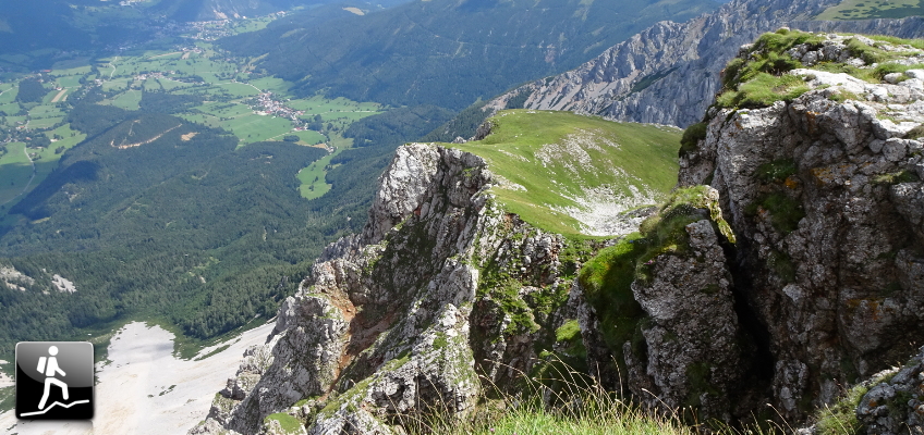
The hiking route from the Schneeberg plateau at an altitude of 1800m, to the summit of Klosterwappen, 2075m above sea level.
- Route description
- Location and directions
- More information
- Author's tip
Climb to the summit of the Schneeberg, the highest mountain in Austria, during this mountain trail tour. Make the journey to the starting point at the summit station of the Schneeberg Railway either comfortably by train, or by hiking from Puchberg after taking the funicular railway. Start by enjoying the breathtaking views from the summit station and visit the mountain inn , the TOP ART 1800 gallery in the summit station, or the Elisabethkircherl (Elizabeth Church) . Then the hike can start. Before you reach the summit, call in at the Damböckhaus . Via the Ochsenboden, proceed to the Klosterwappen , which at 2075m above sea level is the highest point in Lower Austria. Once you have enjoyed this feeling and the view, head a few metres downhill, where you can recover in the Fischerhütte . On the way back, pass the Damböckhaus again, and head to the summit station. A true visual paradise!
Anyone who wants to continue hiking from the Schneeberg summit can do so by following part of the route through the Viennese Alpenbogen !
Schneeberg Railway summit station
Route description Hochschneeberg/Klosterwappen plateau hike
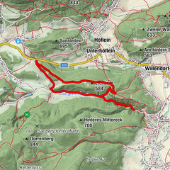
We will follow the green signs to the Damböckhaus, and then continue until we reach the summit cross. The yellow signs lead us to the Klosterwappen, the Schneeberg summit (2075m). We will go along the Schneeberg mountain ridge, to the Kaiserstein and the Fischerhütte. Following the green signs, we will return to Ochsenboden and the summit station.
Travelling from Vienna: Go down the A2 motorway towards Wiener Neustadt, until the Wiener Neustadt West exit. Go along the B26 main road towards Puchberg am Schneeberg. The route is very well signposted.
Travelling from Graz: Go down the A2 motorway towards Vienna, until the Neunkirchen West exit. Go along the B26 main road towards Puchberg am Schneeberg. Follow the signs. Travel from Puchberg to Hochschneeberg with the Schneeberg Railway.
Parking facilities at Puchberg am Schneeberg station.
Take the train from Vienna or Graz to Wiener Neustadt. From there, take the regional train (direction Puchberg am Schneeberg) to the end of the line. There is also a bus service. See www.oebb.at or www.vor.at for more information. Travel from Puchberg to Hochschneeberg with the Schneeberg Railway.
Schneebergbahn, www.schneebergbahn.at
Damböckhaus, www.damboeckhaus.at
Fischerhütte, www.fischer-huette.at
Berghaus am Hochschneeberg, www.berghaus.hochschneeberg.at
Wiener Alpen in Niederösterreich, www.wieneralpen.at , +43 / 2622 / 78960
Puchberg am Schneeberg, www.puchberg.at/tourismus
Bring a suitable map. Wear suitable, sturdy shoes, and bring sun and rain protection, as well as water and a bite to eat. Bring your mobile phone, and save the emergency number of the mountain rescue team: 140
Walking in the Viennese Alps should be a completely safe and beautiful experience. Therefore, please note the following:
Preparation
Make sure that your choice of route matches your hiking experience and your physical condition. Check the weather forecast. In the mountains, the weather can change surprisingly quickly. For this reason, make sure you are well-equipped (e.g. bring rain protection).
Check that the huts and refreshment stations that you want to visit along the way will be open. Tell someone which route you have chosen, and when you hope to return, before you set off.
Tours of the plateau are not recommended in fog and strong winds!
freaytag&berndt WK022
Combine your walk with a stay in Puchberg. For example in the hiking establishment Hotel Restaurant Forellenhof , or Pension Bruckerhof , in the “Geniesserzimmer” (elaborate guest rooms) of the Hotel Schneeberghof , or in the Wellness Kneipp-Kurhotel Wanzenböck .
More tours around the starting point

First Vienna Water Pipeline Trail
3,91 km / 131 egm / 1:20 h / Medium
The source of life for the inhabitants of Vienna lies in…

2-Tages-Wanderung am Raxplateau
23,50 km / 1.423 egm / 10:00 h / Difficult
Schöne und unschwierige, zweitägige Wanderung auf dem…

2-tägige Genusswanderung von Puchberg nach Pernitz
31,14 km / 1.198 egm / 10:00 h / Medium
Diese genussvolle Zwei-Tagestour verbindet…

2-tägige Rundwanderung von Payerbach zur Knofeleben
25,67 km / 1.009 egm / 10:45 h / Medium
Diese genussvolle Zwei-Tagestour führt entlang dem Wiener…

Adventrundwanderweg
6,49 km / 415 egm / 3:00 h
Ein adventlicher Rundwanderweg beim PuchBergAdvent vom 6…

alpannonia - Regionale Route Payerbach - Semmering
21,25 km / 937 egm / 7:00 h / Medium
Diese Route auf der Trasse des Bahnwanderweges führt von…

On the Bahnwanderweg hiking route from Semmering to Payerbach
19,52 km / 448 egm / 6:30 h / Medium
A pleasant all-day hike along the paths of the Viennese Alps…

Anspruchsvoller Wandertipp von Payerbach nach Puchberg
35,47 km / 2.041 egm / 12:30 h / Difficult
Zweitägige Wanderung über den Schneeberg. Der Weg am Wiener…

Auf den Kreuzberg- Speckbacherhütte
12,78 km / 644 egm / 4:20 h / Medium
Diese einfache Wanderung führt vom Sommerfrischeort…

Augenbrünnlrunde
7,71 km / 90 egm / 2:00 h / Difficult
Erleben Sie Reichenau bei einem gemütlichen Spaziergang,…
- About Stefan Probst
- Blog List Summary
- Alpine Tour
- Via Ferrata
Hiking Tour: “Schneeberg via Weichtalklamm (A/B) and Schauerstein”
Climb up to the highest point in Lower Austria: the Klosterwappen via the beautiful Weichtalklamm
The tour starts at the Weichtalhaus and first leads through the impressive Weichtalklamm (easy Via Ferrata cat. A/B) to the Kienthalerhütte . After a short break, the tour then continues to hike up Schneeberg via the Schauerstein , allowing scenic views. After enjoying the impressive distance view from Kaiserstein and a well-deserved lunch break at the Fischerhütte , the tour continues to the highest point of Lower Austria, the Klosterwappen . The tour then descends back towards the Kienthalerhütte and then follows the easier Ferdinand-Mayr-Weg back to Weichtalhaus . Tour Description
At a glance
2021-08-07 09:15

Related Posts:

Leave a Reply Cancel reply
Save my name, email, and website in this browser for the next time I comment.

- Unterkünfte
- Sportanbieter
Schneeberg - Klosterwappen

Anstrengend mit gewaltigem Aufstieg, romantische Klamm mit einfachen und versicherten Klettereien (Vorsicht bei zu großer Nässe), danach nochmals 700 Hm. zum Klosterwappen
Weichtalhaus – Weichtalklamm – Kientalerhütte – Klosterwappen– Fischerhütte – Damböckhaus - Bergstation Hochschneeberg
Das Weichtalhaus auf 547 Meter Seehöhe ist der ideale Ausgangspunkt für eine Wanderung in die Weichtalklamm zur Kienthalerhütte und weiter auf den Hochschneeberg.
Schon nach wenigen Minuten befindet man sich in einer wilden Schlucht mit felsigen Zacken, Geröll und herab geschwemmten Holzteilen. Der Weg ist zwar beschwerlich, aber mit einer guten Kondition ein Genuss für alle Sinne!
Manchmal geht es in der Weichtalklamm nicht ohne Verwendung der Hände. An den schwierigsten Stellen sind aber Steighilfen (Leitern, Ketten) angebracht, sodass der Aufstieg sicher durchgeführt werden kann. Gute feste Schuhe sind allerdings eine Mindestvoraussetzung für diesen Weg, den man eher nur bergauf gehen sollte. Bei Nässe rutschig!
Ca. 200 Höhenmeter nach dem Ende der Klamm ist bald die Kienthalerhütte auf 1380 Meter Seehöhe (nur am Wochenende geöffnet) erreicht. Insgesamt braucht man für den Aufstieg vom Weichtalhaus zur Kienthaler Hütte ca 2,5 Stunden.
Ab jetzt führt ein einfacher Pfad über 700 Hm zum Gipfel des Schneebergs, dem Klosterwappen und danach zur hochalpinen Fischerhütte.
Der gemächliche Weg über das Damböckhaus zur Bergstation der Schneebergbahn führt in die Planung des nächsten Wandertages oder zu einer lieblichen Abfahrt per Bahn (02636-3661) oder www.schneebergbahn.at
Weichtalhaus (02666/52134, Nächtigungsmöglichkeit), Kienthaler Hütte (0680/1406812, nur an Wochenenden geöffnet, N.), Fischerhütte (0676/5893037, N.), Damböckhaus (02636/2259, N.), Berghaus Hochschneeberg (02636/2257, N.)
Bergsteigerausrüstung
freytag & berndt Wanderkarte WK022, BEV Karte 4212-West, kleine Reichenauer Wanderkarte
Tourismusbüro Reichenau 02666/52865
- GPX GPS Exchange Format (XML)
- KML Google Earth, Google Maps

Wegbeschaffenheit
- Hochsteiermark 4058
- Semmering - Rax 2299
- Reichenau / Rax - Raxalpe 929
Beliebte Touren in der Umgebung

Vom Preiner Gscheid zur Heukuppe

Schneeberg - Nandlgrat

Krummbachstein Rundwanderung, NÖ

Schneealpe - abseits der Trampelpfade auf den Windberg

Bergtour – Klosterwappen (2076m)
Aus dem Rother Wanderbuch “Wiener Wanderberge” von Franz Hauleitner / Rudolf Hauleitner, © Bergverlag Rother
Klosterwappen (2076m)
Der beliebteste Anstieg auf den Schneeberg Mit einem Schneeberg -Besuch nach Schema F per Zahnradbahn wird ein echter Bergsteiger natürlich nicht glücklich. Unter den sonst durchwegs langen und anstrengenden Zugängen ist der hier gewürdigte Fadensteig der beliebteste und gebräuchlichste. Die Route startet an dem von Losenheim per Sessellift erreichbaren Fadensattel und folgt dem anfangs steil und felsig, später sanft und begrünt zur Höhe ziehenden Nordrücken zum Kaiserstein und weiter auf das Klosterwappen . Bei 900 Meter Anstiegshöhe wird eine abwechslungsreiche Wanderung mit ständig sich weitenden Ausblicken auf die umliegenden Berggebiete geboten. Vorsicht ist aber bei Schlechtwetter angesagt, denn seiner isolierten Stellung wegen ist dieser Berg den Wetterkapriolen voll ausgesetzt, so dass es dann fast immer besser ist, den Rückzug anzutreten als sich auf ein Risiko einzulassen.
Talort: Puchberg am Schneeberg (585 m). Bedeutender Urlaubs- und Erholungsort in einem Talkessel östlich des Schneeberges. Anreise von Wien mit Bahn, Bus oder eigenem Auto (77 km).
Ausgangspunkt: Von Puchberg mit Bus oder Kfz zur Talstation, 871 m (Großparkplatz), der »Salamander-Sesselbahn Schneeberg« am Oberrand der Fadenwiese in Losenheim, einem kleinen Ort am Ostfuß des Schneeberges, 7 km von Puchberg.
Höhenunterschied/Gehzeit: 1050 m / 6h 15min
Anforderungen/Wegbeschaffenheit: Anspruchsvolle, lange Tour auf markierten Steigen und Wegen. Nur für trittsichere und schwindelfreie Geher bei trockenem Wetter.
Einkehrmöglichkeiten: Sparbacher Hütte (ganzjährig geöffnet, Mittwoch Ruhetag), Edelweißhütte (ganzjährig geöffnet, Dienstag Ruhetag), Fischerhütte (wie die Schneeberg-Zahnradbahn geöffnet), Kienthaler Hütte (zwischen Ostern und Ende Oktober geöffnet), Liftstüberl an der Salamanderlift-Talstation
Variante: Anstieg von Losenheim zu den Schutzhütten am Fadensattel: Vom Großparkplatz an der Salamanderlift-Talstation die Zufahrtsstraße in Westrichtung zu einer Verzweigung (Fahrverbotstafeln, Schranken). Auf unbezeichneter Naturstraße geradeaus den wiesenreichen Lahninggraben aufwärts zu einer Teilung und im Graben steiler bergauf zur nächsten Verzweigung. Die dem Graben folgende Straße führt in Kehren gegen den Fadensattel hoch. Der abkürzende, unbezeichnete Steig folgt der Abfahrtstrasse rechts von ihr. Auf dem Steig westwärts steil und ohne Kehren die Schneise hoch, dann durch lichten Wald und Gesträuch in steilen Windungen in den Fadensattel (1209 m). Auf dem Fahrweg links haltend entweder zur Edelweißhütte oder zur Sparbacher Hütte westlich von ihr. _______________________________________________
Wegverlauf: Von Losenheim (871 m) mit dem kuppelbaren Salamander-Vierersessellift zur Bergstation (1210 m), südlich des Fadensattels (1209 m) am Ansatzpunkt des Schneeberg-Nordrückens .
Von der Bergstation des Salamanderlifts westwärts kurz über Wiesen empor zur nahen Edelweißhütte (1235 m) und weiter zur benachbarten Sparbacher Hütte (1248 m). Dort den rot und gelb markierten Fußweg Nr. 801 nach links (Süden) aufwärts zu einem Zaun (Gatter). Weiter über Wiesen, dann durch Nadelwald am Kaiserstein-Nordrücken in Kehren hinauf unter einen Felsaufschwung. Dieser wird auf einem guten Steig über Schrofen und Geröll rechts umgangen und danach ein Gratabsatz erreicht. Über den begrünten, später gerölligen Rücken in Kehren empor unter die abriegelnden Fadenwände . Am Oberrand der Geröllhänge vorerst nach rechts (Westen), dann nach links in eine kleine Schlucht mit Steinfänger oberhalb. Über die schrofig geröllige Steilflanke unterhalb einer Wand etwas ausgesetzt nach rechts hinauf zu einer Schulter, dann über Schutt in Kehren empor unter einen Aufschwung. Wiederum nach rechts queren, dann über Felsstufen steil nach Süden hoch zu einer grasigen Schulter (1722 m) am Oberrand der Fadenwände . Auf dem nun breiten Weg (Stangenmarkierung) über Bergwiesen in aussichtsreicher Wanderung aufwärts zur Fischerhütte (2049 m). Dort einen angegrünten Hang scharf nach links (Norden) hoch zum Gipfel des Kaisersteins (2061 m) mit prachtvollem Tiefblick in das Puchberger Becken .
Zurück zur Fischerhütte . Auf dem gelb markierten Weg Nr. 801 über den anfangs breiten Höhenrücken südwestwärts hinab in einen Sattel (2030 m). Jenseits empor zum »Mittelgipfel « (2060 m), danach über den schmalen, begrünten Kamm auf das Klosterwappen (2076 m) mit Gipfelkreuz und umfassender Rundsicht: im Nordosten Dürre und Hohe Wand , im Südosten der Waxriegel (Damböckhaus), dahinter das Gahnsplateau mit Krummbachstein rechts. Links überm Gahns die Bucklige Welt , rechts hinterm Krummbachstein Wechsel , Sonnwendstein und Stuhleck . Im Südwesten und Westen Rax , Veitsch , Hochschwab , Gesäuseberge , Haller Mauern und Totes Gebirge . Im Nordwesten Mürzsteger , Ybbstaler , Türnitzer und Gutensteiner Berge .
Vom Gipfel auf dem blau markierten Steig (Weg Nr. 801, Stangenmarkierung) einen angegrünten Steilhang nach Nordwesten hinunter, dann über Wiesen weniger steil bergab, schließlich durch Latschen und lichten Wald mehr nach links (Westen) abwärts zu einer Felsschulter (Vermessungszeichen). Weiter zu einer kleinen Wiese (1508 m) mit dem querenden, gelb und blau markierten Fadenweg. Auf ihm durch Hochwald in Kehren nach links (Südwesten) abwärts zur nächsten Verzweigung und dort rechts haltend bergab zu der am Sattel zwischen Bergkörper und Turmstein idyllisch gelegenen Kienthaler Hütte (1380 m).
Zurück zu der Stelle, wo im Abstieg der Fadenweg erreicht wurde, 20 Minuten von der Hütte. Auf ihm (gelb markiert) geradeaus im lichten, wiesendurchsetzten Wald vorerst in Nordost-, dann in Nordrichtung empor zum Fleischer Gedenkstein (1528 m) (Wegverzweigung), am weiten Sattel zwischen Kuhschneeberg links und Hochschneeberg rechts.
Von hier lohnt der Besuch des am Kuhschneeberg-Plateau gelegenen Ochsenbodens (1520 m) mit informativem Einblick in die mächtige Nordwestflanke des Hochschneeberges . Im Süden, jenseits des Höllentales , die Raxalpe mit dem canyonartigen Großen Höllental . Im Westen der Sonnleitstein , im Nordwesten der Gippel-Göller-Zug ( Mürzsteger Alpen ).
Den breiten, gelb und grün markierten Fadenweg durch lichten Wald und über Bergwiesen geradeaus (nordwärts) bergab zu einer Verzweigung. Rechts haltend über eine Anhöhe hinweg, danach durch einen Graben zur braunen Lacke (Große Lacke) und zum Beginn einer Forststraße. Auf ihr das steile Hochtal der Trenkwiesenschlucht nordostwärts in Kehren hinunter zu einem Wendeplatz (Denkmal). Durch die Schlucht weiter abwärts, später an ihrer rechten Begrenzungsflanke unter den Fadenwänden zur nächsten Verzweigung. Rechts von der Straße ab und auf einem guten Fußweg, an steilen Waldhängen entlang, eben nach Osten zu einer Wiese. An ihrem Oberrand durch Wald mehr nach rechts aufwärts zur Sparbacher Hütte und zur Edelweißhütte . Weiter zur Bergstation der Salamander- Sesselbahn und Talfahrt mit ihr zur Talstation in Losenheim .
Inhaltsverzeichnis
Tourenüberblick:
Tourentipps, unterkünfte und sonstige interessante orte:.
– Kompasskarte (Blatt 210) – Wiener Hausberge (Maßstab: 1:50.000) – Kompasskarte (Blatt 228) – Winer Hausberge, Schneeberg, Rax (Maßstab: 1:25.000) – Freytag Berndt Wanderkarte (Blatt WK 022) – Semmering, Rax, Schneeberg (Maßstab: 1:50.000)
Diese und weitere interessante Wandertouren finden Sie in dem Buch “ Wiener Wanderberge ” vom Bergverlag Rother.
Quelle: Bergverlag Rother

Klosterwappen - Breite Ries - Schneeberg - Skitour
Bildergalerie.

Beschreibung
Ausgangspunkt für die Tour ist Losenheim am Ende der Fahrmöglichkeiten in der Nähe der Talstation des Sesselliftes.
Vom Parkplatz startet man entlang der Skipiste zur Bergstation des Sesselliftes und weiter zur Edelweißhütte, im Frühjahr ist der Beginn oft aper. Unmittelbar nach der Edelweißhütte teilt sich der Aufstiegsweg, entweder nimmt man den kürzeren aber anspruchsvolleren Fadensteig oder man geht weiter entlang der Forststraße bis der Hoyosgraben beginnt. Die weiterste Variante über den Fadenweg führt noch weiter entlang der Straße bis zum Almgatterl.
Über den Hoyosgraben
Man folgt der Forststraße ab der Edelweißhütte, die Straße führt im weiteren Verlauf leicht bergab, nach einigen Felsriegeln und noch bevor sich der Weg in eine Rechtskurve wendet, zweigt man links in lichtem Wald ab. Man steigt nun im Wald teilweise in Kehren zum Hoyosgraben hoch, dem man bis zur Baumgrenze folgt.
Über die nun flacher werdenden breiten Hänge geht man in Richtung Fischerhütte und weiter zum Klosterwappen , welches man am Kamm entlang in ca. 10 Minuten ab der Fischerhütte erreicht. Das Klosterwappen kann auch ausgelassen werden und man geht direkt zum Kaiserstein .
Vom Schneeberg gibt es unzählige Abfahrtsmöglichkeiten, allerdings alle mit einem gewissen Anspruch. Die wohl beliebteste und bekannteste ist die Breite Ries.
Breite Ries
Vom Kaiserstein in nördlicher Richtung an der Geländekante entlang bergab zu einer ebenen Stelle von dort zur Einfahrt in die Breite Ries. Der Einfahrtsbereich ist zugleich die steilste Stelle (ca. 40°), in diesem Abschnitt noch relativ schmal und links und rechts durch Felskämme begrenzt. Nach der Ausfahrt aus dem ersten Bereich geht das Gelände in das breite Kar über. Das bei entsprechenden Verhältnissen schön zu fahrende Kar verlässt man vor der Waldzone links auf den querenden Grafensteig. Nun dem markierten Weg bergab folgen bis dieser links in eine Forststraße mündet, der Straße folgt man bis zur Skipiste (Aufstieg), im Frühjahr meist Tragepassage.
- Der Schneeberg sollte keinesfalls unterschätzt werden, auf der Hochfläche ist die Orientierung bei schlechter Sicht schwierig, man ist dem Wind ausgesetzt und zudem ist auf Dolinen zu achten.
- Die Breite Ries ist, auch wenn sehr oft befahren, eine Steilrinne für die die Bedingungen entsprechend passen müssen.
Informationsstand
Schwierigkeit, orientierung, klettertechnik.

- Direct to main navigation
- Go directly to full text search
- Go directly to contents
Hochschneeberg/Klosterwappen plateau hike
Hiking route from schneeberg railway summit station to schneeberg railway summit station.
7,26 km length
- Difficulty: Medium
- Route: 7,26 km
- Ascent: 298 egm
- Descent: 298 egm
- Duration: 2:50 h
- Lowest point: 1.784 m
- Highest point: 2.075 m
- With refreshment stops
- Suitable for families and children
- Geological highlights
- Botanical highlights
- Faunistic highlights
- Mountain railway ascent/descent
- Summit tour
Details for: Hochschneeberg/Klosterwappen plateau hike
The hiking route from the Schneeberg plateau at an altitude of 1800m, to the summit of Klosterwappen, 2075m above sea level.
- Route description
- Location and directions
- More information
- Author's tip
Climb to the summit of the Schneeberg, the highest mountain in Austria, during this mountain trail tour. Make the journey to the starting point at the summit station of the Schneeberg Railway either comfortably by train, or by hiking from Puchberg after taking the funicular railway. Start by enjoying the breathtaking views from the summit station and visit the mountain inn , the TOP ART 1800 gallery in the summit station, or the Elisabethkircherl (Elizabeth Church) . Then the hike can start. Before you reach the summit, call in at the Damböckhaus . Via the Ochsenboden, proceed to the Klosterwappen , which at 2075m above sea level is the highest point in Lower Austria. Once you have enjoyed this feeling and the view, head a few metres downhill, where you can recover in the Fischerhütte . On the way back, pass the Damböckhaus again, and head to the summit station. A true visual paradise!
Anyone who wants to continue hiking from the Schneeberg summit can do so by following part of the route through the Viennese Alpenbogen !
Schneeberg Railway summit station
Route description Hochschneeberg/Klosterwappen plateau hike
We will follow the green signs to the Damböckhaus, and then continue until we reach the summit cross. The yellow signs lead us to the Klosterwappen, the Schneeberg summit (2075m). We will go along the Schneeberg mountain ridge, to the Kaiserstein and the Fischerhütte. Following the green signs, we will return to Ochsenboden and the summit station.
Travelling from Vienna: Go down the A2 motorway towards Wiener Neustadt, until the Wiener Neustadt West exit. Go along the B26 main road towards Puchberg am Schneeberg. The route is very well signposted.
Travelling from Graz: Go down the A2 motorway towards Vienna, until the Neunkirchen West exit. Go along the B26 main road towards Puchberg am Schneeberg. Follow the signs. Travel from Puchberg to Hochschneeberg with the Schneeberg Railway.
Parking facilities at Puchberg am Schneeberg station.
Take the train from Vienna or Graz to Wiener Neustadt. From there, take the regional train (direction Puchberg am Schneeberg) to the end of the line. There is also a bus service. See www.oebb.at or www.vor.at for more information. Travel from Puchberg to Hochschneeberg with the Schneeberg Railway.
Schneebergbahn, www.schneebergbahn.at
Damböckhaus, www.damboeckhaus.at
Fischerhütte, www.fischer-huette.at
Berghaus am Hochschneeberg, www.berghaus.hochschneeberg.at
Wiener Alpen in Niederösterreich, www.wieneralpen.at , +43 / 2622 / 78960
Puchberg am Schneeberg, www.puchberg.at/tourismus
Bring a suitable map. Wear suitable, sturdy shoes, and bring sun and rain protection, as well as water and a bite to eat. Bring your mobile phone, and save the emergency number of the mountain rescue team: 140
Walking in the Viennese Alps should be a completely safe and beautiful experience. Therefore, please note the following:
Preparation
Make sure that your choice of route matches your hiking experience and your physical condition. Check the weather forecast. In the mountains, the weather can change surprisingly quickly. For this reason, make sure you are well-equipped (e.g. bring rain protection).
Check that the huts and refreshment stations that you want to visit along the way will be open. Tell someone which route you have chosen, and when you hope to return, before you set off.
Tours of the plateau are not recommended in fog and strong winds!
freaytag&berndt WK022
Combine your walk with a stay in Puchberg. For example in the hiking establishment Hotel Restaurant Forellenhof , or Pension Bruckerhof , in the “Geniesserzimmer” (elaborate guest rooms) of the Hotel Schneeberghof , or in the Wellness Kneipp-Kurhotel Wanzenböck .
More tours around the starting point

First Vienna Water Pipeline Trail
3,91 km / 131 egm / 1:20 h / Medium
The source of life for the inhabitants of Vienna lies in…

2-Tages-Wanderung am Raxplateau
23,50 km / 1.423 egm / 10:00 h / Difficult
Schöne und unschwierige, zweitägige Wanderung auf dem…

2-tägige Genusswanderung von Puchberg nach Pernitz
31,14 km / 1.198 egm / 10:00 h / Medium
Diese genussvolle Zwei-Tagestour verbindet…

2-tägige Rundwanderung von Payerbach zur Knofeleben
25,67 km / 1.009 egm / 10:45 h / Medium
Diese genussvolle Zwei-Tagestour führt entlang dem Wiener…

Adventrundwanderweg
6,49 km / 415 egm / 3:00 h
Ein adventlicher Rundwanderweg beim PuchBergAdvent vom 6…

alpannonia - Regionale Route Payerbach - Semmering
21,25 km / 937 egm / 7:00 h / Medium
Diese Route auf der Trasse des Bahnwanderweges führt von…

On the Bahnwanderweg hiking route from Semmering to Payerbach
19,52 km / 448 egm / 6:30 h / Medium
A pleasant all-day hike along the paths of the Viennese Alps…

Anspruchsvoller Wandertipp von Payerbach nach Puchberg
35,47 km / 2.041 egm / 12:30 h / Difficult
Zweitägige Wanderung über den Schneeberg. Der Weg am Wiener…

Auf den Kreuzberg- Speckbacherhütte
12,78 km / 644 egm / 4:20 h / Medium
Diese einfache Wanderung führt vom Sommerfrischeort…

Augenbrünnlrunde
7,71 km / 90 egm / 2:00 h / Difficult
Erleben Sie Reichenau bei einem gemütlichen Spaziergang,…
- Trip Reports
- Areas & Ranges
- Huts & Campgrounds
- Logistical Centers
- Fact Sheets
- Custom Objects
- Plans & Partners
- Schneeberg - Klosterwappen

- Additional Parents
- Perched synclines collected
- Images (194)
- Climber's Log Entries (29)
- Comments (1)
- Additions & Corrections
Schneeberg with the summit Klosterwappen is the highest mountain of Lower Austria (Niederösterreich) and the most eastward 2000m mountain of the alps. Nearly the whole region is a water protection area ( 1 st Vienna water supply )Near Fischerhütte is the summit Kaiserstein - named after emperors Franz I sucessful ascent in 1805 and 1807.Schneeberg is often underestimated (rapid weather changes - with snow, heavy rain, fog, strong winds) - orientation might be very difficult. This YouTube video shows some strong wind near Fischerhütte strong wind near Fischerhütte
In summer (May to November) the rack railway (starting in Puchberg am Schneeberg) is the easiest ascent (about 1 hour walk to the summit).
- South side - Climbing
Very nice climbs in Höllental (near Reichenau an der Rax)
- North Side - Skitouring
in spring time several nice steep ski descents.In winter ski touring starts usually at Losenheim (near Puchberg am Schneeberg).
- Getting There
North side: Puchberg am Schneeberg South side: Reichenau an der Rax by car: Form Vienna on the highway (Südautobahn - A1) to Wiener Neustadt - continue via Ternitz to Puchberg am Schneebergor (for the south side of Schneeberg) from Ternitz (continue an Semmeringschnellstraße - S6) to Gloggnitz to Reichenau an der Rax by train: from Vienna (Südbahnhof) via Wiener Neustadt (you have to change the trains) to Puchberg or to Reichenau. Puchberg and Reichenau bus transfer to the mountains (sometimes!!!)
- Rack Railway
The rack railway was built between 1985 and 1897. The line is 9.85 km long and climbs 1.218m to its final destination at 1,795m. The line has a rail gauge of 1.000 mm and uses the Abt rack systems. Opertion of the rack railway started in 1897 with coal-powered steam locomotives, which have been in use until 1999. The steam locomotives are still in use for nostalgia trains. In 1999 new diesel operated Multiple Units called Salamander, which meet strict environment protection regulations, have been introduced. After World War II until 1996 the rack railway was operated by the Austrian Federal Railways (ÖBB). Since 1997 the rack railway is operated by the Niederösterreichischen Schneebergbahn GmbH (Lower Austrian Schneeberg Railway Company Ltd.) - 50% held by the ÖBB and 50% held by the federal state of Lower Austria
More or less the whole area is a water protection area (first Vienna Water Supply)Krummbachgraben (near Kaiserbrunn) strictly no trespassing!!
- When To Climb - Winter + Spring
- Ski Touring
The steep descents on the north side in spring westward descents: Schneegraben: starts directly at Klosterwappen summitWurzengraben: starts at FischerhütteSalvisgraben: near Schauerstein to DreibrunnekesselHoyosgraben: starts near Vestenkogel to Dreibrunnenkessel Fadengraben: starts near P. 1723 (Fadensteig) In Hoyosgraben (also in Salvisgraben) is a cuesta/cliff (skiing around is usually possible)
Info to "Breite Ries" : descents from left to right:

Narrndattl Rinne, Privat Ries, Breite Ries, Vestenkogel Ostrinne, Rote Schütt Flanke
- When To Climb - Summer
- Climbs on the north side
- Herminensteig
- Novembergrat
- Gamsgartlgrat
- Bürklesteig
- Climbs located in Stadelwandgraben (south side)
(all information in German):
- Plattensymphonie - first climbed in Aug. 2007
- Des Kessels neue Kleider - route first climbed in Oct. 2006
- Neuer Zimmerweg first climb in Stadelwandgraben (first climbed 1906) - "reopened" (cleaned, straightened, bolts etc.) in Oct. 2005
- Bruderherz - a new route (first climbed in 2004) near Richterkante
- Richterkante - this climbing route (first climbed in 1929) has been cleaned, straightened in 2002 (also a lot of bolts now)
- Huts (+ Camping)
no camp sites - camping is forbidden due to water protectionall huts except Edelweisshütte are closed in winter (on weekends a team of mountain rescue members are at Heinrich Krempel Hütte)
Edelweißhütte : 1235m (closed in November)Sparbacherhütte: 1248m has been sold and is no longer openboth huts near Losenheim (45 minutes walk) www.alpenverein.at - Edelweißhütte
Kienthaler Hütte : 1380m usually, open from the beginning of May to end of October on the weekend2,5 - 3 hours from Losenheim, 2,5 hours from Weichtalhaus www.kienthaler.at Heinrich Krempel Hütte : 1561mhut of the Austrian Mountain Rescue (Bergrettung) - the hut is not open to the public (no sleeping facilities, no food - in winter ski tourist may get a hot tea)2 hours from LosenheimThe hut is named after Heinrich Krempel (1880 - 1935) - a cofounder of the Austrian Mountain Rescue Service.

Weichtalhaus : 563m near Reichenau near the road starting point for climbs in the Höllental www.weichtalhaus.at

Fischerhütte : 2049mnear the summit of Kaisersteinopen from beginning of May to end of October1 hour from the top station of the rack railway2,5 hours from Losenheim (on Fadensteig)3,5 hours from Losenheim (via Heinrich Krempel Hütte)Fischerhütte is named after Fischer von Röslerstamm, who wrote the first guidebook of Schneeberg.
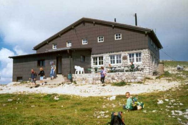
Damböckhaus : 1810m15 minutes from rack railway stationclosed in winter
Naturfreundehaus Knofeleben (Friedrich Haller Haus) : 1250 mclosed in Winter2 hours from Reichenau3 hours from Kaiserbrunn
- Mountain Conditions
Usually the hut wardens give information
- Links (Webcams) - Books etc.
www.schneeberg.tv several Webcams - www.schneeberg.tv (from Fischerhütte, Damböckhaus etc.) www.bergsteigen.at have a look at the "Touren" section of www.bergsteigen.at - sorry only in German.
detailed map online: Austrian Map Online
Skiführer Schneeberg the most comprehensive Alpine Touring Ski Guide Book (by Wolfgang Ladenbauer)
View Schneeberg - Klosterwappen Image Gallery - 194 Images
- Nearby Mountains & Rocks
- Interactive Map
- Mountains & Rocks in Austria
Children refers to the set of objects that logically fall under a given object. For example, the Aconcagua mountain page is a child of the 'Aconcagua Group' and the 'Seven Summits.' The Aconcagua mountain itself has many routes, photos, and trip reports as children.
- View all on Map
- Schneidergraben
- Road along the Zahnradbahn
- Touching the vo... oh somebody has written something like this...
- Höllental - Climbing (Schneeberg Rax)
- Schneeberg - Skitouring Images
Parents refers to a larger category under which an object falls. For example, theAconcagua mountain page has the 'Aconcagua Group' and the 'Seven Summits' asparents and is a parent itself to many routes, photos, and Trip Reports.
- Drahte Kogel
- Castillo de Acher
- Sedlena Greda
- Mont Aiguille
- Castillo Mayor
- Beriain / San Donato
You need to login in order to vote!
Don't have an account.
- Rating available
- Suggested routes for you
- People who climb the same things as you
- Comments Available
- Create Albums
Klosterwappen (Schneeberg) (2.076 m)
- Aus unseren Wandertouren haben wir fünf Wanderwege hierher
- Mittelschwerer Pfad von Damböckhaus 45 Minuten
- Mittelschwerer Pfad von Fischerhütte 11 Minuten
- Wanderweg von Kienthalerhütte 110 Minuten
- Wanderweg von Gipfel Stadelwandhöhe 123 Minuten
- Wanderweg von Weichtalhaus 235 Minuten
Wanderung planen
- Wander-Routenplaner Wege finden und Gehzeit berechnen
- Tour-Planer Wandertour zusammenstellen
- Websuche Normalweg Klosterwappen Wanderung
- Höhe: 2.076 m
- Lage & Anreise: Puchberg am Schneeberg , Österreich
- Breite: 47° 46‘ 1.422 N (47.7670618)
- Länge: 15° 48‘ 16.198 E (15.8044994)
- Dominanz: Kein höherer Berg im Umkreis von 49,05 km
- Schartenhöhe / Prominenz: 1.348 m
- Webcam: n/a
- Schneeberg bei Grub (DE)
- Schneeberg bei Metzels (DE)
- Schneebergrücken bei Molln (AT)
- Schneeberger Weißen (Rocce Bianche di Montenevoso) bei Moos in Passeier (IT)
- Schneebergkreuz bei Mühlbach am Hochkönig (AT)
- Schneeberg bei Mühlbach am Hochkönig (AT)
- Schneeberg bei Neubauer Forst Nord (DE)
- Schneeberg bei Reichraming (AT)
- Schneeberg bei Roßleithen (AT)
- Schneeberg bei Sankt Gallenkirch (AT)
- Kuhschneeberg bei Schwarzau im Gebirge (AT)
- Schneebergerhimmel bei Wenigzell (AT)
- Schneeberg bei Willingen (Upland) (DE)
Nachbargipfel
Hütten in der nähe, in der umgebung.
Hier will ich hin
Fehler melden
Wettervorhersage

Klosterwappen
Wanderausrüstung.
- Stirnlampen wenn es zu früh dunkel wird
- Wanderrucksäcke damit die Brotzeit zum Gipfel kommt
- Kindertragen in der Kraxn schlafend zum Ziel
- Wanderstöcke faltbar immer dabei
- Wanderschuhe ohne Blasen zum Gipfel
- Grödel sicher auf Eis und Schnee
Buchtipp Wanderführer

Schwierigkeit, Gehzeiten, Höhenangaben, Entfernung und Routenverlauf auf der Karte ohne Gewähr.
Warst du schon mal hier? Pletzachkogel Ein Tipp für eine Wanderung: Wanderung Ochsensitz bei Ettal | Wanderung Feldlahnalm bei Unterwössen | Wanderung Engelstein und Bairerkopf bei Bergen und ganz neu hinzugefügt Wanderung Drachenweg Roßhaupten bei Roßhaupten .
- Bathing lakes
- Accommodations
- Sports provider
- Ski resorts
- Cross-country skiing
Weichtalhaus, Kaiserstein, Klosterwappen
Wanderung vom Höllental über die Weichtalklamm zur Kienthalerhütte , weiter zur Fischerhütte, Kaserstein und Klosterwappen. Zurück über Stadelwandgraben zum Weichtalhaus
Weichtalhaus
Klosterwappen
Kienthalerhütte , Fischerhütte, Weichtalhaus
- GPX GPS Exchange Format (XML)
- KML Google Earth, Google Maps

- Hochsteiermark 4040
- Semmering - Rax 2289
- Reichenau / Rax - Raxalpe 927
Popular tours in the area
Losenheim: Edelweißhütte - Fadensteig - Fischerhütte

Vom Preiner Gscheid zur Heukuppe
Krummbachstein Rundwanderung, NÖ
Johannesbachklamm Würflach
- Equipment Hire
… that delights with alpine charm
Puchberg is located 80 km south of Vienna in a dreamily romantic basin at the foot of the 2075 m high Schneeberg Mountain, a real paradise for mountain lovers and for those looking for relaxation. Puchberg has been certified from the Wanderdörfer (Austria’s hiking villages eV) and thus it rose to the nobility of the hikers.
There are numerous of spa and leisure facilities , gastronomy and accommodation establishments. Book a hiking package in one of the excellent establishments or a guided hiking tour in our tourist office .
Comfortable hiking: the ways on Vienna’s Alpine Arch, to relax, regain strength and get spoiled. The wanderers appreciate the way on Vienna’s Alpine Arch with its certified hiking villages and hiking hotels, which ideally connects wandering with high quality demands.
You can find many hiking ways in Puchberg and on Schneeberg here!
We are happy to give you advice and look forward to you!
Guided hiking tours
The hiking village Puchberg am Schneeberg offers its visitors guided tours each Thursday. A registration is required until Tuesday, Tel.: +43 2636 2256. The tours are starting at 9 am and last till approx. 4 pm, absolute walking time is between 3,5 and 5,5 hours, depending on the route. The climbs are with max. 650 meters altitude difference.
We suggest the following equipment: hiking poles, weather protection, filled drinking bottle, eventually a cereal bar because we do not stop until early afternoon for a bite to eat.
Full Moon and sunrise hiking tours
Our tour guides await you at the valley station of Schneebergbahn, front of the tourist counter. At 3.30 pm leaves the Schneebergbahn from Puchberg station and brings you up in 45 minutes to the mountain station of Hochschneeberg. After enjoying the beautiful view in the direction of the Neusiedlersee, we hike through the Ochsenboden (bullock’s ground) to the Fischerhütte. There will be awaiting us already the hosts of the hut, Kathi and Michl with a glass of schnapps. Afterwards you can enjoy a delicious dinner made by the host Kathi. At Moon rise we hike to the summit cross and let us captured by the mystical atmosphere of the full Moon. You can be nowhere else so close to the sky and Moon in east part of Austria than on this place. Next morning we experience the sunrise from the terrace of the Fischerhütte. After a rich breakfast we say goodbye to Kathi and Michl and descend via Schneebergplateau along the hiking route next to the cog railway to Puchberg train station.
Details and facts of the full Moon hiking:
- Meeting point 3 pm at the tourist counter of the train station Puchberg
- Departure with the Schneebergbahn at 3.30 pm.
- Hiking along Schneebergplateau to Fischerhütte ca. 1,5 hours
- Dinner and accommodation in Fischerhütte
- Full Moon hiking to summit cross and back ca. 1 hour
- Sunrise on the terrace of the Fischerhütte, breakfast
- Descend along the cog railway hiking route to Puchberg – ca.4 hours hiking
- Registration: Please book latest 1 week before your desired date under 02636/2256.
Herbs hiking tours
From May till October on each first Tuesday and each first Saturday of the month at 2 pm. Herbs hiking take you along meadows and forests, creeks and tracks. Christine Diertl explains with expertise the herbs, flowers and grasses and their importance and effectiveness in the nature and its use for humans. The tour takes about 2,5 hours long and it closes with a small testing of Christine’s natural products.
The herbs hiking tours are anytime bookable on request. Direct registration for announced appointments as well as for individual tours under tel.: 0676/5053269 or b.diertl@dialog-gruppe.at .
Hiking tour pointer
The hiking tour pointer of Puchberg offers families and children varied, playful tours for the Comfortable mild hiking routes, for the physically Strong climbs to the Alps and for the Alpinists height exceedance.
You can get the stamps at the mountain huts or also at the stations of the chairlift and Schneebergbahn. It is sufficient as well if you attest the goal yourself with your own notation. You receive the pointer then from us in the tourist office or at the tourist counter at train station.
Winter hiking tours
Here you can find at a glance all snowshoe hiking tours of Vienna’s Alps: www.wieneralpen.at/schneeschuh-wandertouren
Hiking tours
Cafe's & restaurants, geführte wanderung, wasserfall – mamauwiese, kaiserebenwiese, weningersteig – breite ries, rohrbach im graben, zahnradbahnwanderweg am schneeberg, paradies der blicke – hochschneeberg, plateauwanderung hochschneeberg / klosterwappen, schoberwände, tut gut wanderweg route 1, tut gut wanderweg route 2, tut gut wanderweg route 3, accomodation, getting here, credits & legal notice.
Puchberg Wanderkarte / 19.11 MB Puchberg Wanderbuch / 168.72 MB

Tour Details
Moscow metro tour: architectural styles of the subway.

Duration: 2 hours
Categories: Culture & History, Sightseeing
This metro tour of Russia’s capital and most populous city, Moscow, is your chance to get a unique insight into the beautiful and impressive architecture of the city's underground stations. Admire their marble walls and high ceilings representing Stalin's desire for glory after World War 2, and see first-hand how the interiors change with the rise of new political eras. Your guide will lead you through the complex network, which is one of the most heavily used rapid transit systems worldwide, with over two billion travelers in 2011.
Opened in 1935, Moscow’s underground system, now 190 miles (305 km) long with 185 stations, is today one the largest and most heavily used rapid transit systems in the world. On this Moscow metro tour, discover the impressive architecture of Moscow’s underground stations and learn how they reflect the Soviet era.
Getting around by metro, your local guide will take you through parts of Moscow’s infamous history. Stop at stations built during the time of the USSR (Soviet Union) that are praised as one of the most extravagant architectural projects from Stalin’s time. After World War 2, he was keen on establishing Stalinist architecture to represent his rising regime and a recognized empire. Learn how when his successor started the de-Stalinization of the former Soviet Union in 1953, the extravagancy of the architecture was toned down.
Discover how the unique character of each station reflected several different eras. While stations like Kievskaya and Slavyansky Bulvar have pompous halls and high stucco ceilings brimming with extravagant decorations, those built later, like Volzhskaya, are lightly adorned with sparse furnishings. Architect Alexey Dushkin and painter Alexander Deyneka were just two of the many artists who made these magnificent landmarks possible.
Revel in Moscow's glory days, as well as the years of scarcity, on this fascinating Moscow metro experience. Conclude your tour at one of the central stations in Moscow. If you're lucky, you may even find the secret entrance to the unconfirmed Metro-2, a parallel underground system used by the government -- a mystery which has neither been denied nor confirmed today.
Nearby tours

Soviet-Era Walking Tour in Moscow: Lubyanka Square and the Gulag History Museum
If you love history, would like to know more about Russia’s past, or just want to take an interesting walk, book this guided Moscow walking tour of Soviet-era sites. With your expert guide, walk through Lubyanka Squ...

Walking Tour of Moscow's Kolomenskoye Estate
On this walking tour through the Kolomenskoye Estate in Moscow, immerse yourself in Russia’s interesting royal history. Walk around the UNESCO World Heritage-listed Ascension Church, built in 1532, and enter the Hou...

Moscow Cultural Walking Tour: Red Square, Kitay-Gorod and St Basil's Cathedral
Take a guided walking tour of Moscow's cultural highlights, like the beautiful UNESCO World Heritage-listed Red Square, said to be the central square of Russia. Walk through the adjoining district Kitay-Gorod, one of ...

Kremlin Grounds, Cathedrals and Patriarch's Palace Tour from Moscow
A great three hour tour exploring the Kremlin Grounds, Cathedrals and Patriarch's Palaces in Moscow! The small city in the center of Moscow, once the residence of Czars and Patriarchs, contains Russia's main cathedra...

Moscow City Tour
The Moscow City Tour covers all the highlights and most beautiful places in the enchanting Russian capital. The tour begins with a stop at the Red Square and St. Basil's Cathedral, the architectural masterpiece and w...
Culture Shock Rating
We have a wide range of tours designed to give you an insight into the destination you're travelling in and there is something for everybody. The culture shock ratings considers the destination visited, transport used, activities undertaken and that "Wow, I'm really not at home now!" factor. While generalisations are always tricky, a summary of our gradings is as follows…
This is the least confronting of our tour range. Transport used on the trip is either private or a very comfortable public option, the activities included are usually iconic sites and locations that are not all too confronting.
The tour can include a mix of private and public transport providing a level of comfort that is slightly below what you would experience at home. Sites visited are usually iconic sites, tours can also include market visits, visits to communities etc that provide the traveller with a fantastic insight into destination.
Expect to rough it for parts of this tour, whether it's a packed public bus where you are forced to stand, a visit to a local market, a local community, you are sure to have an experience that is very different from what you're used to at home.
The comforts of your home town and the environment you are used to are more of a rarity. Expect some challenging transport options, visits to local sites and areas that don't resemble anything at home.
You're out there in the global community! You are likely to be exposed to the elements, travel in whatever means of transport is available and basically take it as it comes, whatever comes! It can be tough.
Physical Rating
Our physical rating gives you an idea of how much huffing and puffing you can expect on the tour. While generalisations are always tricky, a summary of our gradings is as follows…
These tours have very limited physical activity. Usually climbing in and out of the transport provided, walking through sites, markets etc included in the itinerary.
These tours have a bit of physical activity but nothing that should challenge you too much. This could be climbing on and off public transport through to a walk through the destination you're travelling in, they can include walking only tours or a combination of walking and transport.
These tours involve a bit of physical activity from walking up and down hills in the destination you're travelling in or the surrounding areas. Climbing on and off local transport or riding a bike up to 30 kms along predominantly flat terrain or jumping in a kayak for a gentle paddle on flat water.
These Tours will provide you with some solid physical activity. Whether its bike riding, walking, trekking, kayaking or riding on public transport you will need to have a good level of fitness to enjoy this tour.
Be prepared for some serious physical activity. These tours are our most challenging and involve some serious walking, hiking or bike riding. Can involve step climbs by foot or pedal and some challenging public transport options in the destination you are travelling.
Luxury Rating
Some trips are like a stroll on the beach, while others have you trekking alpine passes. Some of you thrive on camping out on the savannah, while others may prefer a hot shower and a comfortable bed in a lodge. Follow the grading systems below to find the right trip for you.
To help you choose the trip that's right for you, we've broken all of our trips down into four service levels. Measuring the comfort level of the accommodation and transport. So whether you're travelling on a budget and want to save money by using public transport, or prefer upgraded accommodation and are happy to pay a little more, then we have a level for you.
This is grassroots travel at its most interesting
Authentic experiences with some of the comforts of home
For those who like to travel in comfort
All the unique experiences wrapped up with a gold ribbon
- Route planner
Florian planned this outdoor adventure with komoot!
Discover your own fun with the #1 outdoor app., plateauwanderung hochschneeberg/ klosterwappen.
- Select Starting Point
- Open in Planner
- Download GPX file
Tour Overview
Schneeberg Klosterwappen
Hiking Highlight
Fischerhütte des ÖTK
Damböckhaus, tour profile, weather forecast.
Florian planned a hike.
June 7, 2020
- Create a Copy of This Tour
- Report Tour
You Might Also Like
Hiking Collection by Tamara (unterwegs)
Hiking Collection by komoot
Moscow Metro Tour
- Page active

Description
Moscow metro private tours.
- 2-hour tour $87: 10 Must-See Moscow Metro stations with hotel pick-up and drop-off
- 3-hour tour $137: 20 Must-See Moscow Metro stations with Russian lunch in beautifully-decorated Metro Diner + hotel pick-up and drop off.
- Metro pass is included in the price of both tours.
Highlight of Metro Tour
- Visit 10 must-see stations of Moscow metro on 2-hr tour and 20 Metro stations on 3-hr tour, including grand Komsomolskaya station with its distinctive Baroque décor, aristocratic Mayakovskaya station with Soviet mosaics, legendary Revolution Square station with 72 bronze sculptures and more!
- Explore Museum of Moscow Metro and learn a ton of technical and historical facts;
- Listen to the secrets about the Metro-2, a secret line supposedly used by the government and KGB;
- Experience a selection of most striking features of Moscow Metro hidden from most tourists and even locals;
- Discover the underground treasure of Russian Soviet past – from mosaics to bronzes, paintings, marble arches, stained glass and even paleontological elements;
- Learn fun stories and myths about Coffee Ring, Zodiac signs of Moscow Metro and more;
- Admire Soviet-era architecture of pre- and post- World War II perious;
- Enjoy panoramic views of Sparrow Hills from Luzhniki Metro Bridge – MetroMost, the only station of Moscow Metro located over water and the highest station above ground level;
- If lucky, catch a unique «Aquarelle Train» – a wheeled picture gallery, brightly painted with images of peony, chrysanthemums, daisies, sunflowers and each car unit is unique;
- Become an expert at navigating the legendary Moscow Metro system;
- Have fun time with a very friendly local;
- + Atmospheric Metro lunch in Moscow’s the only Metro Diner (included in a 3-hr tour)
Hotel Pick-up
Metro stations:.
Komsomolskaya
Novoslobodskaya
Prospekt Mira
Belorusskaya
Mayakovskaya
Novokuznetskaya
Revolution Square
Sparrow Hills
+ for 3-hour tour
Victory Park
Slavic Boulevard
Vystavochnaya
Dostoevskaya
Elektrozavodskaya
Partizanskaya
Museum of Moscow Metro
- Drop-off at your hotel, Novodevichy Convent, Sparrow Hills or any place you wish
- + Russian lunch in Metro Diner with artistic metro-style interior for 3-hour tour
Fun facts from our Moscow Metro Tours:
From the very first days of its existence, the Moscow Metro was the object of civil defense, used as a bomb shelter, and designed as a defense for a possible attack on the Soviet Union.
At a depth of 50 to 120 meters lies the second, the coded system of Metro-2 of Moscow subway, which is equipped with everything you need, from food storage to the nuclear button.
According to some sources, the total length of Metro-2 reaches over 150 kilometers.
The Museum was opened on Sportivnaya metro station on November 6, 1967. It features the most interesting models of trains and stations.
Coffee Ring
The first scheme of Moscow Metro looked like a bunch of separate lines. Listen to a myth about Joseph Stalin and the main brown line of Moscow Metro.
Zodiac Metro
According to some astrologers, each of the 12 stops of the Moscow Ring Line corresponds to a particular sign of the zodiac and divides the city into astrological sector.
Astrologers believe that being in a particular zadiac sector of Moscow for a long time, you attract certain energy and events into your life.
Paleontological finds
Red marble walls of some of the Metro stations hide in themselves petrified inhabitants of ancient seas. Try and find some!
- Every day each car in Moscow metro passes more than 600 km, which is the distance from Moscow to St. Petersburg.
- Moscow subway system is the 5th in the intensity of use (after the subways of Beijing, Tokyo, Seoul and Shanghai).
- The interval in the movement of trains in rush hour is 90 seconds .
What you get:
- + A friend in Moscow.
- + Private & customized Moscow tour.
- + An exciting pastime, not just boring history lessons.
- + An authentic experience of local life.
- + Flexibility during the walking tour: changes can be made at any time to suit individual preferences.
- + Amazing deals for breakfast, lunch, and dinner in the very best cafes & restaurants. Discounts on weekdays (Mon-Fri).
- + A photo session amongst spectacular Moscow scenery that can be treasured for a lifetime.
- + Good value for souvenirs, taxis, and hotels.
- + Expert advice on what to do, where to go, and how to make the most of your time in Moscow.
Write your review
Claudia Looi
Touring the Top 10 Moscow Metro Stations
By Claudia Looi 2 Comments

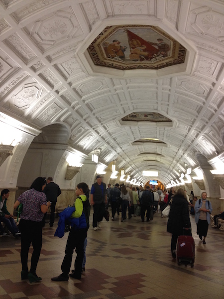
Komsomolskaya metro station looks like a museum. It has vaulted ceilings and baroque decor.
Hidden underground, in the heart of Moscow, are historical and architectural treasures of Russia. These are Soviet-era creations – the metro stations of Moscow.
Our guide Maria introduced these elaborate metro stations as “the palaces for the people.” Built between 1937 and 1955, each station holds its own history and stories. Stalin had the idea of building beautiful underground spaces that the masses could enjoy. They would look like museums, art centers, concert halls, palaces and churches. Each would have a different theme. None would be alike.
The two-hour private tour was with a former Intourist tour guide named Maria. Maria lived in Moscow all her life and through the communist era of 60s to 90s. She has been a tour guide for more than 30 years. Being in her 60s, she moved rather quickly for her age. We traveled and crammed with Maria and other Muscovites on the metro to visit 10 different metro stations.

Arrow showing the direction of metro line 1 and 2

Moscow subways are very clean
To Maria, every street, metro and building told a story. I couldn’t keep up with her stories. I don’t remember most of what she said because I was just thrilled being in Moscow. Added to that, she spilled out so many Russian words and names, which to one who can’t read Cyrillic, sounded so foreign and could be easily forgotten.
The metro tour was the first part of our all day tour of Moscow with Maria. Here are the stations we visited:
1. Komsomolskaya Metro Station is the most beautiful of them all. Painted yellow and decorated with chandeliers, gold leaves and semi precious stones, the station looks like a stately museum. And possibly decorated like a palace. I saw Komsomolskaya first, before the rest of the stations upon arrival in Moscow by train from St. Petersburg.
2. Revolution Square Metro Station (Ploshchad Revolyutsii) has marble arches and 72 bronze sculptures designed by Alexey Dushkin. The marble arches are flanked by the bronze sculptures. If you look closely you will see passersby touching the bronze dog's nose. Legend has it that good luck comes to those who touch the dog's nose.

Touch the dog's nose for good luck. At the Revolution Square station

Revolution Square Metro Station
3. Arbatskaya Metro Station served as a shelter during the Soviet-era. It is one of the largest and the deepest metro stations in Moscow.

Arbatskaya Metro Station
4. Biblioteka Imeni Lenina Metro Station was built in 1935 and named after the Russian State Library. It is located near the library and has a big mosaic portrait of Lenin and yellow ceramic tiles on the track walls.

Lenin's portrait at the Biblioteka Imeni Lenina Metro Station

5. Kievskaya Metro Station was one of the first to be completed in Moscow. Named after the capital city of Ukraine by Kiev-born, Nikita Khruschev, Stalin's successor.

Kievskaya Metro Station
6. Novoslobodskaya Metro Station was built in 1952. It has 32 stained glass murals with brass borders.

Novoslobodskaya metro station
7. Kurskaya Metro Station was one of the first few to be built in Moscow in 1938. It has ceiling panels and artwork showing Soviet leadership, Soviet lifestyle and political power. It has a dome with patriotic slogans decorated with red stars representing the Soviet's World War II Hall of Fame. Kurskaya Metro Station is a must-visit station in Moscow.
Ceiling panel and artworks at Kurskaya Metro Station

8. Mayakovskaya Metro Station built in 1938. It was named after Russian poet Vladmir Mayakovsky. This is one of the most beautiful metro stations in the world with 34 mosaics painted by Alexander Deyneka.

Mayakovskaya station

One of the over 30 ceiling mosaics in Mayakovskaya metro station
9. Belorusskaya Metro Station is named after the people of Belarus. In the picture below, there are statues of 3 members of the Partisan Resistance in Belarus during World War II. The statues were sculpted by Sergei Orlov, S. Rabinovich and I. Slonim.

10. Teatralnaya Metro Station (Theatre Metro Station) is located near the Bolshoi Theatre.

Teatralnaya Metro Station decorated with porcelain figures .

Taking the metro's escalator at the end of the tour with Maria the tour guide.
Have you visited the Moscow Metro? Leave your comment below.

January 15, 2017 at 8:17 am
An excellent read! Thanks for much for sharing the Russian metro system with us. We're heading to Moscow in April and exploring the metro stations were on our list and after reading your post, I'm even more excited to go visit them. Thanks again 🙂

December 6, 2017 at 10:45 pm
Hi, do you remember which tour company you contacted for this tour?
Leave a Reply Cancel reply
You must be logged in to post a comment.
Please go to the Instagram Feed settings page to create a feed.
COMMENTS
The hiking route from the Schneeberg plateau at an altitude of 1800m, to the summit of Klosterwappen, 2075m above sea level. Climb to the summit of the Schneeberg, the highest mountain in Austria, during this mountain trail tour. Make the journey to the starting point at the summit station of the Schneeberg Railway either comfortably by train ...
Klosterwappen. A hike to the summit is one of the classic and most popular routes in southern Lower Austria. The "gentle giant" is equally popular in both summer and winter. The panorama is breathtaking. The next stop is the Fischerhütte (around 20 to 30 minutes on foot) The cloister coat of arms on the Schneeberg is with 2.076 meters the ...
Climb up to the highest point in Lower Austria: the Klosterwappen via the beautiful Weichtalklamm. The tour starts at the Weichtalhaus and first leads through the impressive Weichtalklamm (easy Via Ferrata cat. A/B) to the Kienthalerhütte.After a short break, the tour then continues to hike up Schneeberg via the Schauerstein, allowing scenic views.After enjoying the impressive distance view ...
Ab jetzt führt ein einfacher Pfad über 700 Hm zum Gipfel des Schneebergs, dem Klosterwappen und danach zur hochalpinen Fischerhütte. Der gemächliche Weg über das Damböckhaus zur Bergstation der Schneebergbahn führt in die Planung des nächsten Wandertages oder zu einer lieblichen Abfahrt per Bahn (02636-3661) oder www.schneebergbahn.at.
Anspruchsvolle, lange Tour auf markierten Steigen und Wegen. Nur für trittsichere und schwindelfreie Geher bei trockenem Wetter. ... (2060 m), danach über den schmalen, begrünten Kamm auf das Klosterwappen (2076 m) mit Gipfelkreuz und umfassender Rundsicht: im Nordosten Dürre und Hohe Wand, im Südosten der Waxriegel (Damböckhaus ...
Klosterwappen and Fischerhütte loop is an expert Hiking Tour: 13.1 km and takes 06:25 h. View this route or plan your own! Tamara (unterwegs) planned an outdoor adventure with komoot!
Alles über Klosterwappen, das Ausflugsziel für bergtour, findest du hier - dazu 41 Empfehlungen, 131 Fotos und 5 Insider-Tipps von anderen Abenteurern. komoot. ... Die beliebtesten Touren zu Klosterwappen. Mittelschwer. 27. Klosterwappen - Fischerhütte Runde von Hochschneeberg Bergbahnhof. 02:39. 7,60 km. 320 m. Schwer. 5,0
S. Diff. 03:30. 1250Hm. 7.2km. Der Schneeberg ist als östlichster 2000er der Paradeskiberg der Wiener Hausberge. Die Breite Ries ist ein Klassiker unter den Abfahrten vom Schneeberg, der Aufstieg kann u.a. über den Fadensteig oder den Hoyosgraben erfolgen. Alle Abfahrten vom Schneeberg haben einen gewissen Anspruch.
The Schneeberg (aka Vienna Alps), with its 2,076m high summit Klosterwappen, is the highest mountain of Lower Austria, and the easternmost mountain in the Alps to exceed 2,000m. It is a distinctive limestone massif with steep slopes on three sides.
The hiking route from the Schneeberg plateau at an altitude of 1800m, to the summit of Klosterwappen, 2075m above sea level. Climb to the summit of the Schneeberg, the highest mountain in Austria, during this mountain trail tour. Make the journey to the starting point at the summit station of the Schneeberg Railway either comfortably by train ...
Schneeberg with the summit Klosterwappen is the highest mountain of Lower Austria (Niederösterreich) and the most eastward 2000m mountain of the alps. Nearly the whole region is a water protection area ( 1 st Vienna water supply )Near Fischerhütte is the summit Kaiserstein - named after emperors Franz I sucessful ascent in 1805 and 1807 ...
Tour-Planer Wandertour zusammenstellen; Websuche Normalweg Klosterwappen Wanderung; Steckbrief. Höhe: 2.076 m; Lage & Anreise: Puchberg am Schneeberg, Österreich; Breite: 47° 46' 1.422 N (47.7670618) Länge: 15° 48' 16.198 E (15.8044994) Dominanz: Kein höherer Berg im Umkreis von 49,05 km; Schartenhöhe / Prominenz: 1.348 m; Webcam: n/a
Komoot user Andi recorded a hike: Schneeberg Klosterwappen 2076m. See this route and plan your own adventure with komoot!
Wanderung vom Höllental über die Weichtalklamm zur Kienthalerhütte , weiter zur Fischerhütte, Kaserstein und Klosterwappen. Zurück über Stadelwandgraben zum Weichtalhaus. Winter Summer Weather Webcams Accommodations Tours Search history. Search suggestions. No results found Search Tours. Home
The hiking village Puchberg am Schneeberg offers its visitors guided tours each Thursday. A registration is required until Tuesday, Tel.: +43 2636 2256. The tours are starting at 9 am and last till approx. 4 pm, absolute walking time is between 3,5 and 5,5 hours, depending on the route. The climbs are with max. 650 meters altitude difference.
Mit dem Salamander ging es hinauf wo wir die Tour starteten. Zum Klosterwappen war es sehr steil und etwas gefährlich aber muss man erlebt haben der Schneebe...
This metro tour of Russia's capital and most populous city, Moscow, is your chance to get a unique insight into the beautiful and impressive architecture of the city's underground stations. Admire their marble walls and high ceilings representing Stalin's desire for glory after World War 2, and see first-hand how the interiors change with the ...
Plateauwanderung Hochschneeberg/ Klosterwappen is an expert Hiking Tour: 6.94 km and takes 02:21 h. View this route or plan your own! Florian planned an outdoor adventure with komoot!
Description Moscow Metro private tours. 2-hour tour $87: 10 Must-See Moscow Metro stations with hotel pick-up and drop-off 3-hour tour $137: 20 Must-See Moscow Metro stations with Russian lunch in beautifully-decorated Metro Diner + hotel pick-up and drop off. Metro pass is included in the price of both tours. Highlight of Metro Tour
Go beneath the streets on this tour of the spectacular, mind-bending Moscow Metro! Be awed by architecture and spot the Propaganda, then hear soviet stories from a local in the know. Finish it all up above ground, looking up to Stalins skyscrapers, and get the inside scoop on whats gone on behind those walls.
The two-hour private tour was with a former Intourist tour guide named Maria. Maria lived in Moscow all her life and through the communist era of 60s to 90s. She has been a tour guide for more than 30 years. Being in her 60s, she moved rather quickly for her age. We traveled and crammed with Maria and other Muscovites on the metro to visit 10 ...