
- Scenic Drives
- Road Trip Planner

- Suggestion Box
- Vista Points
- Information
- Campgrounds
- Charging Stations
Home ▼ » Pacific Northwest » Oregon Scenic Drives and Road Trips
Share Link Open in new window

Journey Through Time Scenic Byway
55 Million Years of History
- Download Map/GPS
- Send to Phone
- Print Directions
Related Drives
- Share Pictures
Our free Road Trip Planner will reverse the route and include the places of interests. Click the “Add to Road Trip” above to start planning your next road trip.
Send this link to your phone. Standard text messaging rates apply.
Get directions from your start address to the beginning of and including this scenic drive. Choose either an alternate ending or same as start.
- Starting: * Use GPS
- To: Journey Through Time Scenic Byway
- Ending: Same?
Have more destinations? Use our free Road Trip Planner to completely plan your adventure. Click the “Add to Road Trip” above to start planning your next road trip.

Get a Park Pass
Natural areas along this route require an entrance fee used to protect and maintain our most scenic treasures. Save time by purchasing your forest passes before you go.
- America the Beautiful Annual National Parks Pass 2024-2025
The Journey of Time Scenic Byway stretches 286 miles from Biggs Junction to Baker City through north central to eastern Oregon. Home to some of the richest fossil beds on Earth, the star of this drive is the John Day Fossil Beds National Monument but along the way you will be charmed by the Old West culture and small towns that reveal the lives of early Pioneers and their gold mining, ranching and logging history.

Ideally you should plan on two days minimum to fully explore this region. Encompassing 14,000 acres, the John Day Fossil Beds National Monument is divided into three separate units, Clarno, Sheep Rock and Painted Hills, approximately one hour away from each other.
This road travels through remote and sparsely inhabited areas. Be sure to have a full tank of gas before beginning this drive and fill up or top off whenever you see a gas station as many of the small towns do not have gas stations. There is limited cell phone coverage and restaurants and lodging are separated by large distances so bring snacks and have your hotel or campground reserved. We also recommend having drinking water on hand as summer temperatures are hot — well into the 90s. Don’t let this keep you from exploring this region — be prepared and you will be well rewarded with stunning and unusual landscapes.
We describe the drive starting in Biggs Junction US-97 heading south (from the intersection of I-84), but it can be done in reverse or picked up anywhere along the byway. The drive follows the John Day River, designated a wild and scenic river and the longest undammed tributary into the Columbia River.
In the town of Moro, visit the Sherman County Historical Society and Museum (M2) to learn about the Oregon Trail, early ranching, farming, Native American culture and more through its collection of over 15,000 historical artifacts. The museum is open May-October.
Continuing on US-97, you arrive in Shaniko. The small photogenic town looks like time stopped and is known as a ghost town although about 40 people do live here. In 1903, it was the largest inland wool shipping center in the world. Stroll through town to explore the colorful, historic buildings and general store.
At the town of Antelope, head east on OR-218. In the early 1900s, Antelope was a busy center for cattle and sheep ranching and from 1980-1985, it was the focal point of conflict between the Rajneeshpuram commune who came to live here. A plaque now commemorates the community’s resistance.
Through much of this drive, you’ll wonder if you landed on another planet. Winding roads delight with grand views of unusual rock formations, mountains and hills revealing a rugged tapestry of geologic history.
Stop at the Clarno Unit of the John Day Fossil Beds National Monument (H1) , part of the John Day Fossil Beds National Monument and discover the Palisades. The 150-foot craggy pinnacles were formed about 45 million years ago by a series of ash-laden mudflows that encased the remains of a semitropical forest. There is no visitor center here, but you will find information panels, a shaded picnic area, water fountain and restroom. From the parking lot — literally walk back in time on the Geologic Time Trail, (1/2-mile round trip) each foot of trail representing 37,000 years of history described on interpretive panels. At the end, you will find two other short trails. The Trail of Fossils highlights actual fossils embedded in rock — and you get a little closer to the imposing Palisades. On the Clarno Arch Trail, petrified logs are visible in the cliff face. Note, if you don’t want to walk the Geologic Time Trail, there is a small parking lot to access this area before you get to the main parking lot.
In 18 miles continuing on OR-218 you will arrive in Fossil. Here you will find fuel, dining options, grocery store and outfitters offering fishing and float trips on the John Day River. The John Day River is a draw for fishing large- and small- mouth bass, trout and steelhead.
Harness you inner paleontologist and dig for fossils behind Wheeler High School Fossil Hunting (A3) . A small fee is charged and tools are provided or you can bring your own. The fossil beds were formed 33 million years ago, and capture the Oligocene Period where you will find 35 species of plants — evidence of a warmer and wetter climate. Fossils are plentiful and people of all ages will find it’s quite easy to find them. Note that in the National Parks fossil collecting is not permitted.
Want to learn more? The Oregon Paleo Lands Institute (A2) is a wealth of local geologic information and features fossil displays, guided tours of John Day Fossil Beds National Monument, family fossil hikes, classes, cycle tours and more. Note that this entire area is popular with cyclists, so be careful on the roads.
From Fossil, continue south on OR-19 until the junction of OR-207 at Service Creek. Here the road forks, each road leading to a different unit of John Day Fossil Beds National Monument. Both units are a must-see. Depending on how long you will be in the area, visit each unit as best fits your schedule. The two roads meet up again in Dayville.
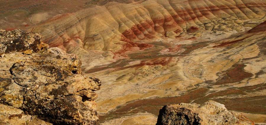
If you take a right on US-26 you head towards the Painted Hills Unit of the John Day Fossil Beds National Monument (H2) from this junction. The main parking area features an oasis of green grass and shade trees perfect for picnics, as well as restrooms and water. Information panels tell the story of the geologic creation of the hills and provides a map of the different hikes and access roads. Whether you hike or just drive by, have your cameras ready and prepare to be awestruck by this unique terrain. All the sights are contained within a small area and we recommend you take every road and stop at each point of interest. The first views of the painted hills are enchanting. Only nature's hand could paint such beauty — layers in a vivid palette of orange, red, black, green, and lavender. The deeply saturated hues are created by different layers of volcanic ash that have oxidized since being exposed to air by erosion. Colors shimmer off the hills and alter at different times of the day and weather conditions. The gentle curves of the dense clay hills are a striking contrast to the rugged surroundings and despite the lifeless look of the landscape, many plants have adapted to the rocky outcrops bringing a wide variety of wildflowers and butterflies. Explore the scenery on three short trails, Painted Hills Overlook and Trail, Leaf Hill Trail and Painted Cove Trail, the latter of which allows you to get very close on a boardwalk that circumnavigates a painted hill. Please do not walk on, or touch the hills as they will be permanently damaged. The Carroll Rim Trail is a 1.5-mile round trip that hugs the mountain-side, climbing 400-feet to a volcanic caprock overlook.
If you take a left on OR-19 you head towards the Sheep Rock Unit of the John Day Fossil Beds National Monument from this junction. Unending sunshine and warm temperatures make for great fruit growing and in Kimberly you will find orchards of apples, pears, plums, nectarines apricots and more. Take advantage of roadside stands or pick your own farms.
Stop at the Foree Area (H4) which features two short quarter-mile hikes offering a panorama of the John Day Valley and volcanic remnants. All hikes along this route offer strategically well-placed benches to soak in the beauty of this area.
Continue south on OR-19, passing the dramatic Cathedral Rock. Drive slowly if you want to take photos, as there is only a small side of the road stop. The surrounding hills are scattered with sagebrush, shadscale saltbush, mountain mahogany and 50 to 200 year old juniper trees.
Back on OR-19, stop at Blue Basin (H3) , mesmerizing badlands of pale greenish/blue volcanic ash now turned to stone. Wind, rain and time have sculpted incredible rock formations, pinnacles, creating a veritable cacophony of texture. Two trails leave from the parking area. The Island of Time is less than a mile long and leads to the center of the basin. Interpretive signage, replica fossils and the scattering of small lizards dot the path. The Blue Basin Trail is a three-mile loop around the perimeter of the basin and affords spectacular views. And remember, have plenty of water, a sunhat and sunscreen.
The road continues revealing fascinating views with every curve. Visit the historic Cant Ranch (A4) built in 1917. Tour inside the home of James and Elizabeth Cant, early sheep ranchers in the John Day Valley and discover original furniture, kitchen, photos and artifacts. The upstairs now houses the park headquarters. Next to the parking lot is a small orchard and some antique ranching and farming equipment. Enjoy a picnic under the trees, a welcome respite from the heat and walk the River Trail, which leads to the John Day River and is wheelchair accessible.
A few miles up the road is the well-designed and informative Thomas Condon Paleontology Center (A5) . The research facility also serves as a visitor center for the entire monument and staff are on hand to answer questions. Take time to explore the fossils and habitats of eight different “assemblages”, each one an ancient ecosystem beginning 50 million years ago, and watch “A Place of Discovery”, the 18-minute film presentation. It’s hard to imagine this area was once a river flood plain with lush forest, prehistoric horses, elephants and saber tooth tigers. As well, you can observe scientists cleaning and studying fossils from the window that overlooks the laboratory.
The road continues through the Columbia basalt lava flows of Picture Gorge (V1) named for the American Indian pictographs on the walls. There are no official stops here, just a few small places to park alongside the river.
Heading towards Dayville, detour up to the Mascall Formation Overlook (V2) for a spectacular view of Picture Gorge and the Mascall and Rattlesnake formations.
The two forks of this drive rejoin in Dayville, a small town with an historic post office and Pony Express sign, some lodging, a restaurant and a grocery store/cafe.
The Clyde Holliday State Recreation Site (H5) is an extremely well-maintained day-use site and green oasis for tent and RV camping — or snag one of the two Teepees by reserving in advance. Walk the path that travels along the John Day River, and depending on the season, search for crawfish and bullfrogs.
John Day is the big city around here and you will find an array of lodging, dining and shopping options. With plenty of services and central location, John Day is a great base for exploring this region.
Don’t miss the Kam Wah Chung State Heritage Site (A6) . The general store and medical clinic was built in the 1870s and became the social hub for Oregon’s Chinese community. The interior is intact — as if the owners Ing “Doc” Hay and Lung On stepped out momentarily. Inside are shelves stocked with supplies, herbal medicines, living quarters, Chinese antiques and more. The Interpretive Center features a video which includes interviews with Doc Hay’s surviving patients. The free museum is open May-October.
Continue east on US-26 toward Prairie City amid beautiful views of Strawberry Mountain.
In Prairie City, visit the Dewitt Museum (M4) housed in the old Sumpter Valley Rail Depot built in 1910. Open from mid-May to mid-October, exhibits take you back to the heyday of rail travel. Tour the first floor waiting room and offices, and head upstairs to the living quarters of the Station Agent featuring antique furniture and artifacts. Also included is a superb collection of rocks and minerals from the DeWitt family, photos and mining tools.
Continue on US-26 to OR-7 to Sumpter. At the Sumpter Valley Railroad (A10) , ride an original narrow gauge steam train traveling between McEwan and Sumpter. Also offered are special events such as Gold Rush Bandit Train Robberies which reenact horseback mounted robberies in period costume, foliage excursions, Christmas trains and more.
Remnants of the gold rush remain at Sumpter Valley Dredge State Heritage Area (A7) . Once vital to Oregon’s pioneer past, this dredge is one of the largest and most accessible gold dredges in the U.S. Enjoy interpretive displays, trails, and picnicking sites at this day-use site.
Learn more about Sumpter’s gold mining past, the great fire of 1917 and more at the Sumpter Museum and Public Library (M5) . Then take a self-guided walk through town or look for treasures at the large flea market held three times each year. The region is also popular for ATV riding and in winter, snowmobiling.
The rest of the drive to Baker City follows a section of the Elkhorn Scenic Byway. Our drive officially ends in Baker City, but there are many places to see once here.
Baker City is a charmer, with over 100 buildings on the National Register of Historic Places in the downtown Historic District. Pick up a brochure at Historic Baker City, Inc. (A8) . and explore on a self-guided walk. In Baker City you will find a wide range of lodging options, restaurants, and services. It is also a hub for recreation to nearby regions.
The National Historic Oregon Trail Interpretive Center (A9) portrays and preserves the challenge of the 2,000-mile journey on the Oregon Trail of settler’s westward migration from Missouri. Eighty-years of history is explored through life-size trail dioramas, living history demonstrations, interpretive programs, hands-on activities and videos. The Center overlooks 7-miles of the Oregon Trail where stagecoach ruts can still be seen. Pan for gold, visit a mine, hike the interpretive trails and much more. There is a fee to enter covered by the America the Beautiful Pass .

- Columbia Gorge
- Hells Canyon Scenic Byway
- More Oregon scenic drives
- Find more scenic drives
- Plan a Road Trip
- Recommend a Stop
- Gas Calculator
- Jump to the map
myscenicdrives.com
How it works.

Oregon Bed & Breakfast Guild

Journey Through Time Scenic Byway – An Oregon Scenic Byway

‘The ‘Wild and Scenic’ John Day River, North America’s second longest un-dammed river, parallels much of the route, offering excellent rafting, fishing, and camping. Geology buffs, and anyone who’s curious about fossils, will take great pleasure in the interpretive trails at the John Day Fossil Beds National Monument. The monument is made up of three units, one of which is the Painted Hills, recently labeled one of the 7 Wonders of Oregon . Thanks to Travel Oregon for sharing this information.

You might consider bringing the bikes and trade out 4 wheels for two. The Old West Scenic Bikeway is a rugged piece of the Old West that you can check out, offering different terrains and scenery, from rushing rivers to hot springs to fossil beds and some attention-getting climbs.
Wilson Ranches Retreat in Fossil, Oregon, a member of the Oregon Bed and Breakfast Guild provides the perfect accommodations when traveling the Journey Through Time Scenic Byway. The Ranch offers up true Oregon hospitality and an Old West Experience.
Oregon Bed and Breakfast Guild is ready to share Oregon with you: it’s environment, culture, and heritage. Combine gracious hospitality with ambiance at an inspected and approved Oregon Bed and Breakfast Guild member Inn.
Hospitality Update : Our inns are following COVID-19 protocol guidance from the Oregon Health Authority.
Although mask guidelines are lifted:
● Some businesses may choose to still require masks.
● Some people may choose to still wear a mask.
We have all struggled through COVID-19 and could use a little kindness. Please be respectful of local businesses and their workers and most importantly kind to yourself.
Leave a Reply Cancel reply
Your email address will not be published. Required fields are marked *
- By Experience
- Inns for Sale
- Central & Eastern
- Mt. Hood and The Gorge
- Portland Area
- Willamette Valley
- Contact OBBG
- Gift Certificates
- 503-893-4210
America's Scenic Byways
- Journey Through Time Scenic Byway
286 miles - Take 5 hours to drive this byway.
Uncommonly rich in history, this route tells stories of fortunes made and lost, of Chinese laborers, of towns boomed and busted, of timber, agriculture, and pioneer settlers. It also tells a special story of the earth's history; of sea beds which have long been dry and of extinct creatures.
The Journey Through Time stretches 286 miles through north central to eastern Oregon. It winds through five Oregon counties, beginning in the community of Biggs and ending in Baker City.
- Prairie City
- © Roadtrippers
- © Mapbox
- © OpenStreetMap
- Improve this map
Journey Through Time
“uncommonly rich in history”.
Uncommonly rich in history, this Byway reveals tales of pioneers, towns boomed and busted and creatures that wandered this terrain millions of years ago. The Journey Through Time Scenic Byway stretches 286 miles through north central to eastern Oregon. Beginning in the community of Biggs and ending in Baker City, this Byway meanders through ghost towns and small farming communities that bring the Old West to life. The “Wild and Scenic” John Day River—North America’s second longest undammed river—parallels much of the route, offering excellent rafting, fishing and camping. Geology buffs—and anyone who’s curious about fossils—will take great pleasure in the interpretive trails at the John Day Fossil Beds National Monument. Historic commemorations of more recent times, such as the Sherman County Museum in Moro, the Kam Wah Chung Museum in John Day, the gold mining remnants in Sumpter and the National Historic Oregon Trail Interpretive Center near Baker City offer telling windows into Oregon pioneer life. Read more about the Journey Through Time
Be the first to add a review to the Journey Through Time.
,path-8+EF4E22(s%7BvuGhdo%60V%7CSo%7D%40leBaq%40h%60%40ocDdiFayKxeCs~%40vwAmpBvsFqLpsBew%40txF%60zJdqDz~%40~tFnyE%60_F_p%40%7CdCfYbhB%7BfBlaDgE%7CfBm%7BB~iCeNtkL%7DrHjyOmx%40vvBwpAv%7DGv_Ajy%40viFjvB%7C_DrjB~k%40lxIqqEvkA%60cAdfBdJ%7Cy%40yxAiRk_KzyAokB%7Bk%40%7BlBdNybIsv%40uo%40sdAynFj_Cepk%40ab%40o%60CuqCofCo%7D%40yoCmg%40fVsJweC_jHlFdNoyD%7CaBk_Fn~GsmEdmEiiAh%5D_jEjuAypCh%7CEi_%40lcHadEg%60AidHeIgiJwcAk~Bh_AoyBgdBijCgnA_fGp%7DBgxDmkA_qDzk%40%7BeAzoB%60Cqb%40%7D%7DBvnAsChP%7ByBrlBev%40~%7BC%7BgH~p%40hl%40fkDcM%7CsHfbAls%40eg%40~xBdOvm%40ykA%60Wxk%40~aE%7BbA_bEzbAaWyk%40wm%40xkA_yBeOms%40dg%40%7DsHgbAgkDbM_q%40il%40_%7CCzgHslBdv%40iPzyBwnArCpb%40%7C%7DB%7BoBaC%7Bk%40zeAlkA~pDi%7DBr%7BD~mArbGfdBhjCi_AnyBvcAj~BdIfiJjcArnFdv%40%7CMvc%40o~%40r~%40%60g%40%60WumAvwDloApkBh%60FnkFv_DtxAbiJrgF_nCrkC%60sIxnDz%7CAnq%40zC%60%5Eqy%40gAsuLx%60IopV%7Dz%40%7BpOefCkgCcq%40rNmb%40mvCnxFcpVxr%40_vK%7BqA_jCl%60CmaAbaGmrPeC_eNftBoiHzvAepX%60r%40oV~xA%7DkI%7Di%40icNtb%40%7DbQwr%40gjJ%7C%5DseVs~D%7BwNijBscOvD%7BwFmsC%7B_DmqEcuAevAseBbEafGk%7D%40upEknBehAsa%40qsBamAaq%40ymA%7Cf%40qcAu%7CBmbEevCwzBcvGrc%40y~AcZezAigCujBtaBqyP_pBwsFgNyzFyhB_SeLgwAqwAmb%40_k%40w_BjlD%7B%7CMiBueJtyDeoKzu%40%7BpO%7Bs%40i%7B%40yvAbKqnAuuAcyKa%7DCqy%40hj%40e_B%7Bj%40qJ%7Cd%40),url-https%3A%2F%2Frtcp.s3.amazonaws.com%2Fq%2F16(-117.835816209448,44.7798984220224)/auto/300x172@2x?access_token=pk.eyJ1Ijoicm9hZHRyaXBwZXJzIiwiYSI6ImNsdjQ5N2VtZDA2bW8ycW13ZHAxeGhjbjkifQ.UIccpoAxc7g3BAuK4s9vjg)
Keep exploring with the Roadtrippers mobile apps.
Anything you plan or save automagically syncs with the apps, ready for you to hit the road!
Connect with us and hit up #roadtrippers
Tall tales, trip guides, & the world's weird & wonderful.
- Roadpass Digital
- Mobile Apps
Business Tools
- Partnerships
Get Inspired
- Road trip ideas by state
- National parks
- Famous routes
- Voices from the Road
Fresh Guides
- The ultimate guide to Mammoth Cave National Park
- The Ultimate Guide to Badlands National Park
- Route 66 Leg 2: St. Louis to Tulsa
- Route 66 Leg 1: Chicago to St. Louis
- Route 66 Leg 3: Tulsa to Amarillo
- Top 10 things to do in Ohio
- Offbeat Road Trip Guides
- Road Trip USA
- Scenic Routes America
- National Park Road Trips
- Terms and Conditions
USPS suggests the address below
Time to upgrade your browser.
If you're reading this, you're surfing using Internet Explorer 6, an eight-year-old browser that cannot cope with the demands of the modern, secure internet. For the best web experience, we strongly recommend upgrading to Firefox , Opera , Safari , Google Chrome , or a more recent version of Internet Explorer .
- Columbia River Gorge Links
- Columbia River Gorge Introduction
- Orientation
- Nearby Destinations
- Statewide Links
- Oregon Destinations
- Visit Other States
- Visit Other Countries
A summary of what Columbia River Gorge has to offer.
Detailed overview for Columbia River Gorge, with custom maps, points of interest, and helpful things to know before you go.

Oregon's "Rose City" is both green, as in eco-conscious, and green, as in lush, a river edged port city that's also a laid-back multi-cultural urban center with forest and mountains a stone's throw from downtown attractions.
- Tour Companies
- Tourist Attractions
- Sightseeing Opportunities
- Recreational Activities
- Things To Do - Overview
- Attractions
- Scenic Drives
- Scenic Flights
- Sightseeing Tours
- Free Travel Planners
- Adventure Trips
- Balloon Flights
- Bird Watching
- Horseback Riding
- Houseboating
- Offroad - ATV
- Climbing / Canyoneering
- RV Parks Camping
- Scuba - Snorkel
- Skiing - Boarding
- Snowmobiling
- White Water Rafting
- X-Country Skiing
- Spas & Wellness
Searchable list of Columbia River Gorge tour companies, guides and outfitters, rental companies and more.
Full information on Columbia River Gorge Tourist Attractions, Scenic Drives and other easy vacation activities…
- Whitewater Rafting

- Lodging - Hotels, Resorts, etc.
- RV Parks - Campgrounds
- Restaurants
Searchable listings of Columbia River Gorge hotels, motels, resorts, bed & breakfast, and more.
Searchable listings of Columbia River Gorge RV parks and campgrounds.
Searchable listings of Columbia River Gorge restaurants, bars, diners, and more.

Use our easy Lodging Search to find exactly the type of accommodation you are looking for at the right price.
Tourism Resources
- Free Visitor Guides!
- Transportation
- State Facts
Travel articles related to Columbia River Gorge…
Columbia River Gorge weather report, historic temperatures and climate info,…
Searchable lists of Columbia River Gorge tourism offices and other helpful government agencies.
Explore destinations near Columbia River Gorge.

- Columbia River Gorge Photo Gallery
- Columbia River Gorge Video Gallery
- Oregon Photo Gallery Oregon Video Gallery

- Connecticut
- Development
- Massachusetts
- Mississippi
- New Hampshire
- North Carolina
- North Dakota
- Pennsylvania
- Rhode Island
- South Carolina
- South Dakota
- Washington D.C.
- West Virginia
Journey Through Time Scenic Byway
Columbia river gorge.
- Introduction
- Sightseeing Overview
- Recreation Overview
- Photo Gallery
- Video Gallery
Description
Points of interest, map + directions, helpful links.
The Journey Through Time Scenic Byway discovers in several hours what took the Earth millions of years to create. In addition to incredible change in geography, flora, and fauna, there are uncountable remnants and traces left from pioneers, Chinese laborers, and frontiersmen.
The Journey Through Time Scenic Byway starts from Baker City, 300 miles east from Portland. The drive starts west on HWY 7 past Austin, then west on HWY 26 to Mitchell. Go north on HWY 207 to Kimberly, northwest on HWY 19 to Fossil, then west on HWY 218 to Antelope. From Antelope, go north on HWY 97 to I-84 on the Columbia River and the end of the drive.
The story of the Earth is told over every mile along this drive. Ancient seabeds and glacial movement creating wide valleys and fields are just some of the many variations of terrain and time along this route. Untouched beauty is easily accessible to the careful eye and traveler. Hiking is a great way to get to know the land and small towns dot the route where one can get to know the history of the region's people and their way of life.
Baker County Unlimited
Points of interest along the way, baker city historic district (or).
Of the 110 buildings in the Historic District, 60 have been restored to their original elegance. Some are now banks, bed and breakfasts, and museums, etc. Restorations are continuing; the tall and white 1927 Baker Hotel, (the site of political conventions,) is being redone at the time of this writing (summer 2000).
Baker City was known as the 'Queen City of the Mines,' and by1900, its population was larger than Boise's (at the time.) An excerpt from the Walking Tour Guide : 'Restaurants in fine hotels served superb cuisine…the opera house was frequently filled to capacity…The 1800 block on the east side of Main had five saloons and several brothels. Children and ladies avoided the block, but the Salvation Army band played there nightly, hoping to rescue fallen souls.'
Baker City/Baker Valley (OR)
Known early on as the "Queen City of the Mines," Baker City sits along the Powder River between the dramatic Elkhorn Ridge of the Blue Mountains and the Wallowa Mountains. Turn-of-the century Victorian architecture dominates the commercial and residential buildings of the city's downtown, earning it distinction as a National Historic District. Many buildings have been carefully restored, including the famous Geiser Grand Hotel.
The Oregon Trail Regional Museum highlights the area's history and houses a fantastic rocks and minerals collection. The Adler House Museum preserves the furnishings and ambiance of an early businessman and community philanthropist. Like the other communities along the Byway, Baker City is friendly and casual.Caution: after spending a couple hours here, you won't want to end your Byway adventure.
John Day Fossil Beds National Monument (OR)
Within the heavily eroded volcanic deposits of the scenic John Day River basin is a well-preserved fossil record of plants and animals. This remarkably complete record, spanning more than 40 of the 65 million years of the Cenozoic Era (the "Age of Mammals and Flowering Plants") is world-renowned.
Authorized October 26, 1974, and established in 1975, this 14,000 acre park is divided into three widely separated units; the Sheep Rock Unit, Painted Hills Unit, and Clarno Unit. The monument's main headquarters is at the visitor center in the Sheep Rock Unit.
Oregon Trail Regional Museum (OR)
Built in 1920, 'The Old Nat' ('Natatorium' is a Latin derivative meaning: 'indoor swimming pool') is on the National Register of Historic Places. This was the area's swimming pool for decades. It is now an interesting museum with a natural history focus.
Sumpter (OR)
Sumpter still looks much like it did in the 1860s, when it was founded during a gold rush; all of the buildings are made of rough-hewn wood. With a population of about 120, this town has a surprising amount of commerce: antique and gift shops, camps where you can pan for gold, a steakhouse, and lodging.
This is where the famous Sumpter Valley Gold Dredge sits, where the Sumpter Valley Railroad runs, and is also known for its hundreds of miles of great snowmobiling.
Sumpter Valley Gold Dredge (OR)
The dredge looks like the ghost of a mammoth and strange boathouse. Built in 1935, the Sumpter Valley Gold Dredge mined $4.5 million in gold until it stopped 11 years later. During those years, the dredge worked 24 hours a day, in all kinds of weather. It only stopped on Christmas and Independence Days.
The dredge has moved 2 miles from the place it was built-dredges work by moving along as they extract gold. The dredge is being restored in stages. Right now, there are wooden walkways to go out to the dredge (it stands in a pond) and a few interpretive signs.There is even a button you can push to hear a recording of a worker telling stories about the dredge over the roar of the machine in operation.
Sumpter Valley Historic Railroad (OR)
This 10 mile (roundtrip) railroad trek takes you from Sumpter to McEwen and back. This line started in 1890 to haul logs to a new sawmill. It soon expanded to carry passengers to Baker City. The line's length eventually reached 80 miles. It started losing business in the 1920's to automobiles, and was fully abandoned in1947. The engines and cars that are used for the ride are fully restored.
Main Roads:
Customizable directions.
- Advertising
- Privacy Policy
- Report a Problem
- Make A Suggestion

- Go Travel Sites
- Houseboating.org
Email Page Link

Oregon's Mt Hood Territory Northern Oregon
Oregon's mt hood territory.

Albany Visitors Association Central Oregon
Albany visitors association.

Frontier Oregon
To request your selected free visitor guides, please fill out the form below and click "Submit".
Your request has been processed, thank you!
We also have the following visitor guides in Oregon. Click on any additional guides you would like to receive. Your submissions were successful, thank you! ' )); tpsButtonClicked.closest( 'div.popup' ).hide( ); $('#before-Dest-State-Travel-Planners').hide();$('#after-Dest-State-Travel-Planners').show(); } ); ">Request these additional visitor guides selected below
We also have visitor guides available in states highlighted in blue below. Click on any state to see what's available.
Switch to Mobile Browser Mode
We offer a compact version of Go-Oregon for mobile users, allowing you to access just the information you need on the road. Of course, you can still use the full version of Go-Oregon on your mobile device just as you can on your desktop.
Continue to Mobile Site Return to Main Site
Frameable Wanderings
Oregon’s journey through time scenic byway, part 2. a living ghost town..
There are more than 80 ghost towns sprinkled throughout Oregon. The first stop on Oregon’s Journey Through Time Byway is 58 miles southeast of Biggs in Wasco County at the ghost town of Shanico.
Shaniko traces its beginnings to August Scherneckau, a Civil War veteran, who began operating a stagecoach stop called Cross Hollows on the route from the Dalles to central Oregon after the war. The natives of the region pronounced his name as Shaniko which eventually became the town name. A post office was established at Cross Hollows in 1879 with Scherneckau as postmaster. However, this post office ceased operation in 1887.

In 1900, a group of businessmen planned the building of a community at the terminus of the Columbia Southern Railroad. This town was to serve as a center for the collection of the huge quantities of wool being produced by sheepmen in central Oregon. A post office was built officially naming the town Shaniko followed by the Columbia Southern Hotel (later renamed the Shaniko Hotel). Due to the arid nature of the area, water had to be pumped from Cross Hollow Canyon through a wooden piping system and stored in two large wooden tanks.

The town of Shaniko was incorporated in 1901. It had a bank, two blacksmith shops, a two-story multipurpose building housing the city hall, fire station, and jail, a post office, two stores, two newspapers and five saloons. The three-room school housed grades kindergarten through high school, and, on Sundays, served as the church.
In 1902, a large warehouse was built where wool was collected and stored, and by 1903, Shaniko was dubbed “The Wool Capital of the World.” In 1904, more than 5 million dollars-worth of wool was sold to buyers in Shaniko (about $146 million today).

In 1911 a railroad line linking Bend with the Columbia Gorge was built. This coupled with a fire that destroyed much of the downtown business area led to the demise of Shaniko. Although sheepmen, ranchers and homesteaders stayed on in the area, the town’s heyday was over.
Today, the population of Shaniko is about 37 residents so it is classified as a “living” ghost town. You can wander the streets of town and see the remnants of old buildings, antique farm equipment and old cars and trucks. The most notable building found at the edge of town is one of the old wool warehouses. The old truck near the warehouse is one of the most photographed antique vehicles in all of Oregon.

You can still see the watertower, city hall/jail, a blacksmith shop, stage station, chapel and some other old buildings. The Shaniko Hotel and school have been restored while most of the other buildings are in various states of decay. One interesting restored building is an old Texaco station. Unfortunately, when I was there, the facility was closed and the antique pumps were covered so you could not see what they look like.
Although many articles written about Shaniko indicate that you can explore the old buildings, I did not find this to be the case with unfriendly no trespassing warnings posted most places.
Shaniko is worth an hour’s stop to see some of the old buildings and antique vehicles if you are driving in the area. However, I went there as a destination and was a bit disappointed.
1 comment on Oregon’s Journey Through Time Scenic Byway
I’ve driven through Shaniko a few times; thanks for all of the information! An interesting history, for sure.
Comments are closed.
Recent Posts
- In Search of the Swamp Fox January 27, 2024
- Of Lemurs and Fossa July 16, 2023
- Adventuring FAR, FAR Off The Beaten Path July 10, 2023
- Wildlife of the Tongass June 18, 2023
- Cruising the Tongass May 17, 2023
- Mission/Vision
- Support NSBF
- Board of Directors
- Staff (part-time)
- America’s Byways Collection
- Best Scenic Drives by State
- Seasons Along Byways
- Iconic Multi-State Trips
- Plan A Byway Adventure
- Newsletters
- Current Members
- Become a Member
- NSBF Byway Awards
- IPW and more
- Webinars & Workshops
- Byway Leader and State Coordinator Training
- Conferences
- Our Supporters
- Byway Journeys
- Visitor Information
- Webinars Access
- Byway Resource Library
- Travel Byways
Journey Through Time Scenic Byway
- Designation State Byway
- Location OR
- Length 286 miles

This route begins at the Columbia River, the traditional fishing and gathering grounds for generations of Native Americans.The byway heads east along OR-218 from Antelope to the 2 Clarno Unit of the John Day Fossil Beds National Monument. Trails lead through an amphitheater of blue green clay stone and up to an overlook of the John Day River Valley.
Update this byway information today!
Quick Links
- NSBF Membership
- Training, Events & Advocacy
Keep up with the latest news of byway efforts and events
First Name *
Last Name *
Your Email *
Byway Affiliation(s), if any
Byway Organization Position, if any
© 2024 National Scenic Byway Foundation.
- A fearful flyer’s guide to train travel on the Coast Starlight
- Updated: Apr. 26, 2024, 3:05 p.m. |
- Published: Apr. 26, 2024, 9:00 a.m.
The lounge car of the Coast Starlight train offers scenic views between Washington, Oregon and California.
The view from the Coast Starlight just north of the California/Oregon boarder.
The Coast Starlight train doesn't have wifi and often no cell reception. Bring a book to pass the time while enjoying the views.
Portland Union Station in 2020.
A roomette on the Coast Starlight train can sleep two. The two seats fold down and receive a mattress to turn into a bed. There's a second bunk above.
The lounge car of the Coast Starlight train offers scenic views between Washington, Oregon and California. South of Santa Barbara, the train pases oceanfront views.
Dining service on Amtrak is included with a room in a sleeper car. Guests can eat at a table in the dining car or, shown here, eat in their room.
The family room in an Amtrak train (in this case, the Texas Eagle) sleeps four, with two overhead bunks and two floor-level beds that fold out.
- Samantha Swindler | The Oregonian/OregonLive
If you already had a fear of flying, this isn’t your year to travel.
First there was the pilot charged with attempting to crash a plane that was diverted to Portland International Airport. Then, of course, a door plug fell off a plane somewhere over Washington County. Since then, a number of news articles have convinced me that my flying phobia isn’t so off the mark after all.
So, last month, I spent six days roundtrip traveling via Amtrak from Portland, down to Los Angeles via the scenic Coast Starlight , and east to Houston, Texas, aboard the Texas Eagle and Sunset Limited .
For all but one of the nights on the trains, I traveled first class in a sleeper car, where travelers get a private room with meals included.
My train trip cost a total of about $3,000. A roundtrip flight would have been somewhere in the range of $500.
Was it worth it? To someone with a crippling anxiety around flying, absolutely. Here’s what you can expect on a cross-country Amtrak journey, along with a few tips I learned along the way.
The biggest difference between air and rail travel is the first: the boarding experience.
As a “arrive at the airport two hours before your flight” person, I had no need to stress at the train station. Arriving 15 minutes before departure is plenty of time.
You just walk up to the train when it’s time to board and have your ticket scanned. No security check, no shoes being removed, no one looking at my luggage. I never even showed an ID. (Lest you get any ideas, a police dog did make the rounds in the Los Angeles Union Station lounge.)
The Coast Starlight route has 30 stops along 1,377 miles from Seattle to Los Angeles, cutting across the Cascade Range in Oregon, through Klamath Falls and Sacramento, and eventually traveling along the Pacific Ocean in Southern California. From Portland to L.A., travel time is about 30 hours.
The Coast Starlight’s claim to fame is its lounge car, which is open to all train passengers on a first come, no holds basis. With massive, curved windows that reach into the ceiling, it’s the best way to see the landscape.
(And a bonus for those who feel claustrophobic on planes: every large window doubles as an emergency exit.)
The train passes golf courses and prisons, orchards and oil rigs, cities and tiny towns. It’s a great way to see the country in all its diversity.
There’s a shared awe and camaraderie in the lounge car, where everyone whips out their phones in unison and others beckoning you over for the best views. Those views happen on both sides of the train. If you see a steep incline outside your window, turn around. Odds are there’s a breathtaking cliff and vista on the other side.
In Oregon, you’ll pass Willamette Falls in Oregon City and the 5th Street Public Market in downtown Eugene. In the tiny town of Westfir, you can see the Office Covered Bridge , built in 1944 across the North Fork Middle Fork Willamette River, before climbing through the mountains.
There’s one section where you’ll want to plan ahead to snag a west-facing seat in the lounge car: The tracks between Santa Barbara and Ventura run right along the ocean.
Another thing about Amtrak: You can’t book a seat or a room on a specific side of the train. Because the cars are able to be pulled from either direction, the booking agent won’t be able to tell you whether you’ll be looking east or west on the day of your travel. If you don’t like your window view, check out the lounge car.
Meals in the dining car are included when you book in the sleeper car, but you can purchase them from coach. It’s $20 for breakfast, $25 for lunch and $45 for dinner.
Each dining car booth seats four, and if there aren’t four in your party, there will be at dinner. This was my favorite part of the trip — dining with different strangers for every meal. But if that’s not for you, sleeper car travelers can also get their meals delivered to their rooms. I also heard an attendant offer to deliver meals to people in their coach seats.
Compared with airline food, train food is haute cuisine. It comes on a real plate for starters. I had fresh salads, vegetarian pasta dishes, a burger, and a fabulous blueberry cheesecake.
The trains also had cafe cars, where anyone can purchase snacks, hot meals and drinks, including alcohol. Cash and cards accepted.
First class vs. coach
If you have the resources, an upgrade to a sleeper car for multi-day trips is worth every penny. I had a roomette for much of the trip, which was just enough for a single rider but might be a tight squeeze for two, particularly if either traveler has mobility issues. The two facing seats recline to form a narrow cot; a second cot folds down from an upper bunk. Your car attendant will provide turn-down service and set up your mattress, blankets and pillows.
I spent two days in the family room of the Texas Eagle, which is designed to sleep four but is downright luxurious for one. The room spanned the entire train width and had two windows. Neither space had its own toilet or shower, but the shared facilities in the sleeper car are just fine.
I never had the opportunity to stay in a bedroom , but that comes with two beds, one window, a sink, and a tiny shower/toilet combo bathroom.
I wouldn’t recommend an overnight coach trip. While you can get up, walk around, sit at a cafe table or get some air in the lounge car, you’re ultimately going to spend an entire night trying to sleep next to a stranger.
If you plan to travel via sleeper car, book your tickets far in advance. I had difficulty finding a room for the duration of the Coast Starlight.
The Amtrak website will only allow you to book either coach or first class for the duration of your time on a train, but you might find that a room is available for a shorter segment. I was unable to book a roomette from Los Angeles to Portland, but later learned there had been a room available from Sacramento to Portland. If you can’t find what you’re looking for online, speak to an Amtrak agent by calling 1-800-USA-RAIL.
Train culture
Plane travel is a means to an end. I find it hard to believe that anyone enjoys flying. They do it because they want to be someplace else, and that someplace is not the cabin of a Boeing 747.
Most first-class train travelers, however, are here for the journey. I met lots of retirees who had the time (and financial resources) to slow-travel the country. Some had been on the rails for weeks at a time, stopping at various cities. One fellow passenger, Linda Groover of California, told me the train was the most romantic way to travel.
“I worked for American Airlines for many years,” she said, “and I was exposed to just about every kind of flight you can imagine, including a flight around the world. But when you take a train, you see the land, you see the countryside, you meet the local people, and it’s just far more adventurous. It’s also relaxing.”
Most everyone is happy to chat – under the right circumstances. I had wonderful, engaging conversations with all my dining companions. But those conversations were only obligated to last a half-hour. I was reluctant to even make eye contact with the woman who was my seatmate in coach for 24 hours. No one wants to open that Pandora’s box.
What to bring
Amtrak’s website advertises “free wifi on trains!” but you need to look at the fine print to find out which trains, and those trains do not include the Coast Starlight, Texas Eagle or Sunset Limited.
Not only will you not have wifi, you often won’t have cell service.
Once you accept this, it’s actually quite freeing.
Bring a few books.
Other things to bring:
- An extension cord with multiple outlets. This is helpful in both the rooms (which come with a single outlet) and in coach, where an outlet might be on the other side of your seatmate.
- Small bills to tip the staff, especially in the sleeper car. The car attendant will turn down your bed each evening and schedule reservations for you in the dining car. There are also servers for each meal.
- Flip-flops for the shower, just like those college-dorm days. You’ll only have access to a shower in the sleeper cars, but even coach has a toilet/changing room where you’ll have space to change clothes.
- In coach, bring your own blanket and pillow. These are only provided in the sleeper cars. Wear comfortable shoes or bring slippers to put over your socks in coach. Don’t be the guy who goes shoeless. Ugh.
- Amtrak allows passengers two 50-pound carry-on bags, up to 28-by-22-by-14-inches each, plus a personal item like a briefcase or backpack, for no extra fee. If you’re taking a multi-night train ride, pack the things you’ll need in your personal bag, and either check your big luggage or stow it in the luggage racks. I learned the hard way that a large suitcase won’t fit in a roomette. An Amtrak employee recommended I check my luggage through to Portland while I was in coach so I didn’t have to worry about anyone grabbing my bag from the luggage rack during a random stop.
There’s so much to see along an Amtrak journey. You can stretch your legs either between cars or during several short stops along the way.
“ Slow travel” costs more and takes longer, but if you can’t handle the stress of flying, it’s a great alternative.
-- Samantha Swindler covers features for The Oregonian/OregonLive and Here is Oregon . Reach her at [email protected] .
Our journalism needs your support. Subscribe today to OregonLive.com .
Stories by Samantha Swindler
- These Oregon bicycle rides feed the need for tweed
- Why would anyone want to kill a talking crow? Watch all 12 episodes of the mystery of Cosmo
- Is Cosmo the talking crow still out there?: Part 12
- Confronting the neighbors over Cosmo the talking (and missing) crow: Part 11
If you purchase a product or register for an account through a link on our site, we may receive compensation. By using this site, you consent to our User Agreement and agree that your clicks, interactions, and personal information may be collected, recorded, and/or stored by us and social media and other third-party partners in accordance with our Privacy Policy.
Use of and/or registration on any portion of this site constitutes acceptance of our User Agreement (updated 4/18/2024), Privacy Policy and Cookie Statement , and Your Privacy Choices and Rights (updated 12/31/2023).
© 2024 Advance Local Media LLC. All rights reserved ( About Us ). The material on this site may not be reproduced, distributed, transmitted, cached or otherwise used, except with the prior written permission of Advance Local.
Community Rules apply to all content you upload or otherwise submit to this site.
YouTube’s privacy policy is available here and YouTube’s terms of service is available here .
Opt out of the sale or sharing of personal information
If you opt out, we won’t sell or share your personal information to inform the ads you see. You may still see interest-based ads if your information is sold or shared by other companies or was sold or shared previously.

10 Scenic Byways In Arizona That Are Perfect For A Road Trip
- Arizona offers an abundance of scenic byways perfect for road trips, allowing travelers to experience the state's diverse landscapes and natural beauty.
- Some notable scenic drives in Arizona include the Red Rock Scenic Byway in Sedona, the Coronado Trail - National Scenic Byway, and Historic Route 66, each offering unique attractions and stunning views.
- From the iconic Grand Canyon to lush forests and historic sites, Arizona's scenic byways provide a range of opportunities for outdoor activities, hiking, and sightseeing throughout the year.
Located in the Southwest region of the United States, Arizona, also known as the Grand Canyon State, is a perfect destination for travelers who want to soak up beautiful scenery. It has an open and vast landmass and enjoys an Arid climate in most parts of the state. Since it is among the four corners of the country, it shares its borders with Mexico, Utah, California, and New Mexico.
The Grand Canyon is the state's most visited and most popular attraction . But the state has plenty of other things that can be as fun and entertaining. It is filled with mountains, plateaus, rivers, parks, museums, and more. A road trip is one of the best ways to explore the state. Here are 10 scenic byways in Arizona that are perfect for a road trip.
Enchantment Resort: A Luxurious Stay Amongst Sedonas Red Rocks
Historic route 66, experience the iconic mother road in arizona from kingman through petrified forest to exit 23 on i-40.
Historic Route 66 is the Mother Road of America. It has been used in TV shows, songs, and novels and is considered America's most famous historic highway. The section that goes through Arizona is quite impressive. There are several attractions along the way, including Jack Rabbit Trading Post and Petrified National Forest (Home Of Petrified Woodland, Fossils, And Petroglyphs) . The road enters Arizona from Kingman, and its terminus is exit 23 on Interstate 40.
- Distance: 358 miles
- Road trip length : Around 5.5 hours
- Best time to go: Late spring, early summer and early fall
Apache Trail Historic Road
Discover natural wonders like tonto bridge along this historic road from apache junction.
The journey begins at Apache Junction and ends at Theodore Roosevelt Dam . Along the way, travelers can marvel at the beautiful natural wonders. The road got its name from the Apache Indians that occupied the area and has been a popular drive for Arizona residents and international guests. While enjoying the trip, remember to stop at the Tonto Natural Bridge State Park to see the world’s largest travertine arch bridge , Fish Creek Hill, Lost Dutchman State Park , and Canyon Lake for exceptional views of nature.
- Distance: 120 miles
- Road trip length: 3–4 hours
- Best time to go: Spring
Coronado Trail - National Scenic Byway
Twist and turn through high deserts & forests from us-191 to 180 in springerville.
The road begins at US 191 and concludes at 180 in Springerville. It is a narrow route with numerous twists and turns. Widely acknowledged as the curviest road in the United States, it takes tourists on a journey from a 3,500-foot elevation climb to almost 7,000 feet. The route traverses deserts and forests, offering glimpses of the footpaths once used by Native Americans and the areas where nomads, hunters, and gatherers once resided. Some points to stop over are Apache Sitgreaves National Forest , Hannagan Meadow, Morenci Open Pit Copper Mine , and Archaeological Park in Springerville .
- Distance: 119 miles
- Road trip length: 3+ hours
- Best time to go : All seasons
Patagonia-Sonoita Scenic Road
Traverse varied terrain of the santa cruz river basin, which is great for birding & wildlife.
The Patagonia-Sonoita byway is perfect for travelers seeking a beautiful drive across the desert. Taking visitors across varied terrain, this route offers many opportunities to watch birds and wildlife that call the Santa Cruz River Basin home. Some of the spots travelers don't want to miss include Patagonia Lake State Park and the Creek Sanctuary .
- Distance: 52.5 miles
- Road trip length: 2–4 hours
- Best time to go: Spring and fall
Kaibab Plateau–North Rim National Scenic Byway
Journey through lush forests to the grand canyon's stunning north rim, starting at jacob lake.
Kaibab Plateau's main highlight is the national forests that surround the road. The drive is a trip on the northern side of the famous Grand Canyon. It takes visitors through all the greenery like conifer forests, ponds, limestone outcrops, alpine meadows, and more. The drive starts at Jacob Lake and continues to the Northern Rim of the Grand Canyon. Stop at Cape Royal Trail or the Point Imperial Trail for scenic hiking, or take a side trip to Zion National Park .
- Distance: 44 miles
- Road trip length: Over 1 hour
- Best time to go: November through mid-May
Mt. Lemmon Scenic Byway
Drive through forests up mt. lemmon near tucson, stopping to hike and take in beautiful views.
Also known as the Catalina Highway or the Sky Islands Scenic Byway, the road starts at Tuscon's northeast end, climbs to Mount Lemmon's foot, and ends at Mt. Lemmon Ski Resort, home to the southernmost ski field . Most of the road passes through Coronado National Forest , and travelers can camp and hike in many areas. With every turn, passengers get to see beautiful rock formations. Stop at Windy Point , The Forest Service Ranger, and Mount Lemmon for incredible hiking.
- Distance : 27 miles
- Road trip length: 1–2 hours
- Best time to go : Any time of the year
10 Arizona Road Trips That Are Best Taken In Winter
Black hills back country byway, see the gila river on this adventurous drive through dense forests near safford.
This is the best road for those who love a thrilling drive. It offers a challenge for hikers and mountain bikers. There are also many opportunities to watch wildlife, ride on horseback, fish, hunt, and take pictures. The Black Hills region forms part of the Gila River. Riders can enjoy a picnic at the old Safford Bridge or join other people floating down the river. The road follows US 191 and ends at milepost 160 in Clifton.
- Distance: 21 miles
- Road trip length: 60–90 minutes
- Best time to go : Summer
Discover The Beauty Of Arizona On These 16 Scenic Drives Near Phoenix
Monument valley, iconic southwest landmarks & navajo sites surround you on this striking 17-mile loop.
Found along the border of Utah and Arizona and within the limits of the Navajo National Reservation, this route is a suitable drive for outdoor adventurers. Along the route, travelers experience the southwest’s most iconic scenery . The region was named after the Navajo tribe that occupied the area many years ago. Travelers can spend the whole day in the area as there are many sights to explore. Since it is part of the Colorado Plateau, expect to see many landmarks like Tribal Loop, Teardrop Arch , Mystery Valley , and Three Sisters .
- Distance: 17-mile loop
- Road trip length: 2–3 hours
Red Rock Scenic Byway
See fascinating rock formations like bridges & canyons along az-179 through sedona's red rocks.
One of Sedona’s most scenic drives is a journey across the city, following Arizona Highway 179, which offers breathtaking views of the iconic red rock formations and picturesque landscapes. It is perfect for travelers who want to enjoy outdoor activities while driving. There are plenty of opportunities to hike, bike, and golf. Enjoy the beauty of The Bell Rock Highway and make stopovers at the Chapel of the Holy Cross , Cathedral Rock , and Bell Rock Vista . The drive begins in Sedona and takes travelers to the Village of Oak Creek.
- Distance : 14.3 miles
- Road trip length: 20 minutes
- Best time to go: Summer, spring, and fall
Harquahala Mountain Backcountry Byway
Marvel at grand vistas over the gila & san francisco valleys on this backcountry route.
One of the best scenic trips to take in Arizona , this one begins at the Eagle Eye Road and ends in the Harquahala Mountains. Travelers can hike, camp, mountain bike, fish, and watch birds along the way. One of the best stops is the Gila Box Riparian National Conservation Area , where travelers can see cliff dwellings, historic buildings, and wildlife. Owl Creek Campground is a great place to camp and have a picnic. Then, proceed to hike the Guthrie Peak trail .
- Distance: 10.5 miles
- Best time to go: Between October and May

Day trip paradise: What to know about Western NC's Forest Heritage Scenic Byway

There are 62 scenic byways in North Carolina. Some of Western North Carolina's most famous include the Blue Ridge Parkway and Mount Mitchell Scenic Drive.
There is another one closeby worth checking out: The Forest Heritage Scenic Byway starts in Brevard and leads drivers to scenic locations like Looking Glass Falls.
Forest Heritage Scenic Byway winds through about 64 miles of scenic WNC, passing through the Pisgah National Forest and intersecting the Blue Ridge Parkway and Waterfall Byway along the way.
Like the parkway, the Forest Heritage Scenic Byway area is chock full of things to do and see. Here's your guide.
More: Bucket list scenic byways: See where the Blue Ridge Parkway ranks
More: Should Blue Ridge Parkway have National Historic Landmark designation? What to know.
Where is the Forest Heritage Scenic Byway?
A dedicated page on Scenicbyways.info states that the Forest Heritage Scenic Byway is 64 miles in length, a drive of around two hours. Beginning in Brevard and ending in Rosman, the road features areas perfect for recreation and scenic views including Sliding Rock, Pink Beds bog, several waterfalls and plenty more.
According to Romanticasheville.com, elevation of the byway ranges from around 2,100-5,340 feet.
More: US Forest Service sets spring reopening date for Catawba Falls
Things to do on the Forest Heritage Scenic Byway
It would be easy to turn a two-hour drive of the byway into a weekend trip. Here are a few of the many options for enjoying the area:
- Hiking - With most of the byway winding through Pisgah National Forest, it should come as no surprise that there are plenty of hiking options available along the way. Enjoy waterfall hikes including Twin Falls and Moore Cove Falls , the unique bog environment of Pink Beds Loop and many more.
- Camping - Hoping to stay the night? Enjoy the river-adjacent Davidson Campground or former logging camp Sunburst Campground .
- Swimming - The byway also includes multiple swimming options, including the waterfall swimming hole at Looking Glass Falls and the famous naturally formed Sliding Rock.
- Picnicking - Enjoy picnicking and river access at Coontree Picnic Area , Sycamore Flats Picnic Shelter and plenty more directly along the byway's path through the forest.
- Culture & education - Driving the byway is also an excellent chance to learn about the area's rich natural and cultural history through institutions like the Pisgah Center for Wildlife Education and the Cradle of Forestry.
What is a scenic byway?
To be designated a National Scenic Byway by the US Department of Transportation, a byway must meet the criteria for at least one of the following six "intrinsic qualities":
- Archeological
- Recreational
The dedicated webpage says that these features contributing to the distinctive characteristics of the corridor’s intrinsic quality should be recognized throughout the region, and considered regionally significant. In other words, National Scenic Byways are known for having something for everyone.
Iris Seaton is the trending news reporter for the Asheville Citizen Times, part of the USA TODAY Network. Reach her at [email protected].
IMAGES
VIDEO
COMMENTS
Journey Through Time Scenic Byway. Travel Oregon, Author. September 21, 2011 (Updated September 1, 2017) Distance: 286 m / 460 km. Best time to drive: Year-round. Driving time: 8-10 hours. Scroll Zoom. The marks of time are stamped across the landscape on this 286-mile/460-kilometer route through prehistoric fossil beds, mining boomtowns and ...
The Journey Through Time stretches 286 miles through north central to eastern Oregon. It winds through five Oregon counties, beginning in the community of Biggs and ends in Baker City. Length: 286 miles / 457.6 km Driving Directions From Baker City, go west on SR 7 past Austin, then west on US 26 to Mitchell.
The Journey of Time Scenic Byway stretches 286 miles from Biggs Junction to Baker City through north central to eastern Oregon. Home to some of the richest fossil beds on Earth, the star of this drive is the John Day Fossil Beds National Monument but along the way you will be charmed by the Old West culture and small towns that reveal the lives of early Pioneers and their gold mining, ranching ...
The Journey Through Time Scenic Byway stretches 286 miles through north central to eastern Oregon. Beginning in the community of Biggs and ending in Baker City, this Byway meanders through ghost towns and small farming communities that bring the Old West to life. The Wild and Scenic John Day River - North America's second longest undammed river ...
5. Hood River Fruit Loop Scenic Drive. The Hood River Fruit Loop is a must do 35-mile drive around the Hood River Valley in Oregon. Along the way, you'll experience views of Mt. Hood and Mt. Adams, as well as lush wildflower meadows on Mt. Hood itself. This is a fun short and easy scenic drive to hit while visiting Hood River.
The Journey Through Time Scenic Byway stretches 266 miles through north central to eastern Oregon. Beginning in the community of Biggs and ending in Baker City, this Byway meanders through ghost towns and small farming communities that bring the Old West to Life. 'The 'Wild and Scenic' John Day River, North America's second longest un ...
Journey Through TimeScenic Byway. Journey Through Time Scenic Byway is a scenic byway in the U.S. state of Oregon. [3] It spans five Oregon counties and comprises portions of U.S. Route 97, Oregon Route 218, Oregon Route 19, U.S. Route 26, and Oregon Route 7. [4] [5] The John Day River meanders through much of its route. [1]
The Journey Through Time stretches 286 miles through north central to eastern Oregon. It winds through five Oregon counties, beginning in the community of Biggs and ending in Baker City. Uncommonly rich in history, this route tells stories of fortunes made and lost, of Chinese laborers, of towns boomed and busted, of timber, agriculture, and ...
The Journey Through Time Scenic Byway stretches 286 miles through north central to eastern Oregon. Beginning in the community of Biggs and ending in Baker City, this Byway meanders through ghost towns and small farming communities that bring the Old West to life. The "Wild and Scenic" John Day River—North America's second longest ...
The Journey Through Time Scenic Byway leads to Shaniko, one of Oregon's most popular ghost towns, set on the sagebrush plains of Central Oregon. Among the haunted remnants of what was once the "Wool Capital of the World" are the weathered structures of a historic hotel, a jail and a schoolhouse. Remaining residents are surprisingly ...
Oregon has 29 designated Scenic Byways/Tour Routes which highlight the varied landscapes of the state. These routes fall into one of four designations - All-American Roads, National Scenic Byways, State Scenic Byways, and Tour Routes. This fall I have been exploring the Journey Through Time Scenic Byway, one of the nine State Scenic Byways.
The Journey Through Time Scenic Byway starts from Baker City, 300 miles east from Portland. The drive starts west on HWY 7 past Austin, then west on HWY 26 to Mitchell. Go north on HWY 207 to Kimberly, northwest on HWY 19 to Fossil, then west on HWY 218 to Antelope.
The ability to access Oregon's diverse natural beauty, as well as historical and cultural sites has earned it 29 designated Scenic Byways and Tour Routes. On some byways, you'll drive from high desert to snowcapped peaks to verdant valleys in one go. You'll experience breathtaking views of Hells Canyon, Crater Lake, the Columbia River Gorge and ...
A sign read: "45th Parallel. Halfway Between The Equator And The North Pole." Also known as the Journey Through Time Scenic Byway, this road is the passage for the journey from the all-but-abandoned Shaniko north to Biggs, at the intersection of Highway 97 and I-84. photo by Talia Galvin
Part 2. A Living Ghost Town. There are more than 80 ghost towns sprinkled throughout Oregon. The first stop on Oregon's Journey Through Time Byway is 58 miles southeast of Biggs in Wasco County at the ghost town of Shanico. Shaniko traces its beginnings to August Scherneckau, a Civil War veteran, who began operating a stagecoach stop called ...
The ability to access Oregon's diverse natural beauty, as well as historical and cultural sites, has earned it 29 designated Scenic Byways and Tour Routes. On some byways, you'll drive from the high desert to snowcapped peaks to verdant valleys in one go. You'll experience the breathtaking views of Hells Canyon, Crater Lake, the Columbia ...
Journey Through Time Scenic Byway. Details. Designation State Byway ; Location OR; Length 286 miles; Statewide Byway Partners. Oregan Byways Map. Website 888-275-6368. Travel Oregon. Website 800-547-7842. ... Trails lead through an amphitheater of blue green clay stone and up to an overlook of the John Day River Valley.
The Journey Through Time Scenic Byway begins in Baker City and passing over the Blue Mountains through the John Day River Valley and John Day Fossil Beds, before ending in Biggs. Travelers enjoy incredible vistas of Eastern Oregon's diverse and stunning landscape along the way, including the Painted Hills.
The Outback Scenic Byway The sounds - and colors - of silence. 9: The Rogue-Umpqua Scenic Byway Two raging rivers run through it. 10: The Journey Through Time Scenic Byway Put your car in drive and your sense of time in reverse. 11: The Blue Mountains Scenic Byway Back through fascinating history. Up through incredible scenery. 12: The Elkhorn ...
Travel through 50 million years...in about day...along Oregon's Journey Through Time Scenic Byway. Modern life co-exists with fossils from millions of years...
The byway begins at Biggs, along the Columbia River, and curves up US-97 between the canyons of two more major Oregon rivers: the Deschutes and the John Day....
journey through time scenic byway The 286-mile Journey Through Time Scenic Byway runs from Biggs Junction to Baker City, and passes by some of Oregon's best high-desert attractions on the way.
The Cascade Lakes Scenic Byway may only be 66 miles long, but it is a drive filled with volcanic peaks, glaciers, and amazing scenery. It begins on the west side of Bend on OR-372, going towards ...
From wildlife to waterfalls, Highway 202 offers a journey that's well worth taking the extra time. It's a slow and scenic path full of wildlife and waterfalls along the journey to Astoria. Skip ...
The lounge car of the Coast Starlight train offers scenic views between Washington, Oregon and California. South of Santa Barbara, the train pases oceanfront views. Dining service on Amtrak is ...
Also known as Highway 240, the Badlands Loop State Scenic Byway passes through 31 miles of buttes, cliffs, and spires, and showcases Badlands National Park ($30 a vehicle for seven days) with its ...
They can take a road journey through California over the 110-mile-long (177 km) Rim of the World Scenic Byway, which is known for its incredible panoramas along the San Bernardino Mountains ...
Coronado Trail - National Scenic Byway Twist and turn through high deserts & forests from US-191 to 180 in Springerville. The road begins at US 191 and concludes at 180 in Springerville.
Forest Heritage Scenic Byway winds through about 64 miles of scenic WNC, passing through the Pisgah National Forest and intersecting the Blue Ridge Parkway and Waterfall Byway along the way.