- National Parks
- Tiny Houses

20 Best Backpacking Trips In Utah
Posted by Mac Misseldine July 31, 2019 Updated November 05, 2023
We research, evaluate and select travel destinations based on a number of factors, including our writers’ experience, user reviews and more. We may earn a commission when you book or purchase through our links. See our editorial policy to learn more.
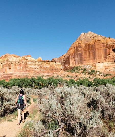
Whether you’re planning an overnight adventure or a weeklong backpacking trip, you’ll find plenty of worthy trails with stellar sights in the Beehive State.
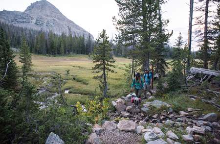
Locals and visitors will find an unbelievably diverse range of backpacking trails at their disposal in Utah. Up north, the Wasatch-Uinta-Cache National Forest serves up an alpine paradise replete with rocky peaks, lush pine and aspen forest, pristine mountain lakes, and more waterfalls than you can count.
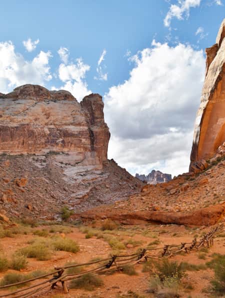
Down south, the scenery shifts to a red rock desert landscape with fascinating rock formations, epic canyons, and the largest collection of natural arches on the planet.
Thanks to the climate diversity, backpacking is a year-round activity in Utah. When it’s hot out, head to the mountains in northern Utah to cool off. When the weather turns cold and the Wasatch Range is covered in snow, head south to Grand Staircase-Escalante , Zion , and Arches National Parks to thaw your frozen limbs.
In short, no matter the season or how much time you can spare, there’s always a backcountry trail calling your name in Utah.
The Wasatch Range
Red pine lakes.

Why you should go : Visit two of the most popular alpine lakes in Utah.
- Distance : 6.8 miles
- Elevation Gain : 1,940 feet
- Difficulty : Hard
The trail to Red Pine Lakes delivers one of the best hikes in Little Cottonwood Canyon. The popular day-hike is even better when you make it an overnighter, providing more time to explore the picturesque Upper and Lower Red Pine Lakes and the surrounding Lone Peak Wilderness .
After you’ve had a chance to visit Red Pine Lake, plan another backpacking trip to its sister lake in Little Cottonwood Canyon — White Pine Lake . It’s a longer hike (10 miles round trip), but the intense blue water is out of this world.
More Information: Visit Utah
Lone Peak Area To Bells Canyon

Why you should go : Utah’s first congressionally designated wilderness features fascinating rock formations, alpine ridges, lush valleys, and panoramic views.
- Distance : 12 miles
- Elevation Gain : 5,000 feet
- Difficulty : Very Hard
The trek from the Schoolhouse Springs Trailhead to Bells Canyon highlights the best features of the Lone Peak Wilderness Area and Little Cottonwood Canyon.
You’ll ascend a drainage area with several mountain meadows to Lake Hardy, an alpine lake that sits directly between Big Horn and Chipman Peak near Thunder Mountain. We recommend stopping here to camp for the night — mostly for the spectacular views, but also because it’s the only reliable water source near the crest.
From here, you can either head back the way you came or continue over the ridge into Little Cottonwood Canyon. We prefer the latter as the hike to Bells Canyon explores Thunder Mountain and features more mountain lakes, streams, and waterfalls.
More Information : Visit Utah
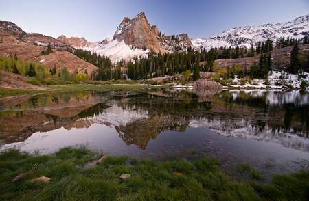
Lake Blanche

Why you should go : Camp between three alpine lakes at the foot of Sundial Peak.
- Distance : 7 miles
- Elevation Gain : 2,720 feet
Lake Blanche has been a popular destination for backpackers in Utah since the 19th century. It’s hard to say what’s more beautiful — the trio of Lake Blanche, Lake Florence, and Lake Lillian, or the imposing Sundial Peak that dominates the skyline.
The trail is also a favorite of geologists, featuring fascinating quartzite formations carved by glaciers when the canyon formed thousands of years ago.
Related Read: Everything You Need to Know About Backpacking with Kids
Mount Timpanogos
View this post on Instagram A post shared by Holly Geilman (@4seasons2run) on Jul 29, 2019 at 5:31pm PDT
Why you should go : A simple overnighter with the best views in Utah Valley.
- Distance : 14.3 miles
- Elevation Gain : 4,566 feet
Perhaps the most iconic mountain along the Wasatch Front, Mount Timpanogos beckons to every backpacker within sight of its photogenic peaks. It’s possible to reach the summit on a long day-hike, but you’ll enjoy the journey more on an overnight backpacking trip.
There are two paths to the top of Mount Timpanogos. The Timpooneke Trail is the shorter, more popular route. The Mount Timpanogos Trail from Aspen Grove is arguably more scenic, but it’s also a mile longer, steeper, and a little more challenging.
Whichever route you choose, the result is the same: stunning panoramic views in every direction as far as the eye can see, and a lifetime of bragging rights.
More Information : Hiking Project
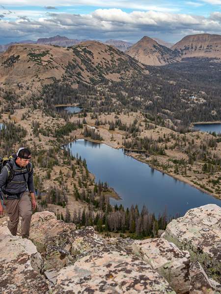
The Uinta Mountains
Ibantik lake.
View this post on Instagram A post shared by Brant Beckstrand (@beckstrandenterprises) on Jul 15, 2018 at 3:46pm PDT
Why you should go : An overnighter with four alpine lakes and a mountain pass that delivers gorgeous views.
- Distance : 8.5 miles
- Elevation Gain : 1,123 feet
- Difficulty : Moderate
The hike to Ibantik Lake packs a lot of scenery for such a relatively short trip. You’ll pass three mountain lakes — Wall Lake, Hope Lake, and Lake Lovenia — and have the chance to spend the night near the shore of Ibantik Lake, an alpine lake that lies in a cirque. You’ll enjoy some great views along the way, especially from the Notch Mountain Pass after Hope Lake.
Amethyst Basin
View this post on Instagram A post shared by Louis Kamler (@uintatrekker) on Jul 18, 2019 at 5:04pm PDT
Why you should go : The best backpacking adventure in the High Uintas Wilderness.
- Elevation Gain : 1,900 feet
See the best features of the High Uintas Wilderness with a tour of Amethyst Basin. The picturesque basin boasts multiple alpine lakes and waterfalls surrounded by a grand mountainous landscape.
This isn’t exactly a beginner trail, but the moderately challenging hike is great for new backpackers with a healthy set of legs — especially if you break it up into three or four days.
Trail Information : The Outbound
Red Castle Lakes
View this post on Instagram A post shared by Kelsey Kagan (@kelseykagan) on Sep 5, 2017 at 8:40am PDT
Why you should go : A red rock paradise in the High Uintas replete with a towering rock formation and several alpine lakes.
- Distance : 25 miles
- Elevation Gain : 3,010 feet
It’s a long road to Red Castle Lakes, but the slow-and-steady pace makes the elevation gain pretty doable.
You’ll wind through a lodgepole pine forest with tranquil mountain meadows, then ascend a series of switchbacks before the Red Castle comes into view. Lower Red Castle Lake is just ahead, and yes, you’re free to take a dip in the water to cool off after a long day of hiking.
Lower Red Castle Lake is magnificent, but it’s a popular camping area that can get a little crowded. For those seeking seclusion, press on another three miles to Red Castle Lake. You can also make the quick hike up to Upper Red Castle Lake and Red Castle itself to enjoy more of the local sights.
King’s Peak
View this post on Instagram A post shared by Jacob Huff (@jacobhuff6) on Jul 30, 2019 at 5:14pm PDT
Why you should go : Summit Utah’s highest peak and enjoy astounding views of the Uinta Range.
- Distance : 26.8 miles
- Elevation Gain : 5,118 feet
At 13,528 feet, King’s Peak takes the cake for the tallest mountain in Utah. It may not be a Colorado 14er, but King’s Peak is known for having one of the most dramatic prominences in the lower 48 states. You’ll enjoy incredible top-of-the-world views that are well worth the ascent.
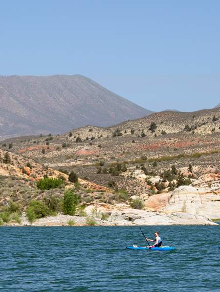
There are at least four well-known trails to King’s Peak, so you can pick your starting point on any side of the mountain. Henry’s Fork Campground is the most popular place to begin, especially if you bring a fishing pole or kayak and have an extra day to spend on the water.
On your journey to the top of King’s Peak you’ll pass a number of picturesque mountain lakes, including Alligator Lake, Sawmill Lake, Bear Lake, Grass Lake, Henry’s Fork Lake, and Dollar Lake.
Trail Information : Utah Travel
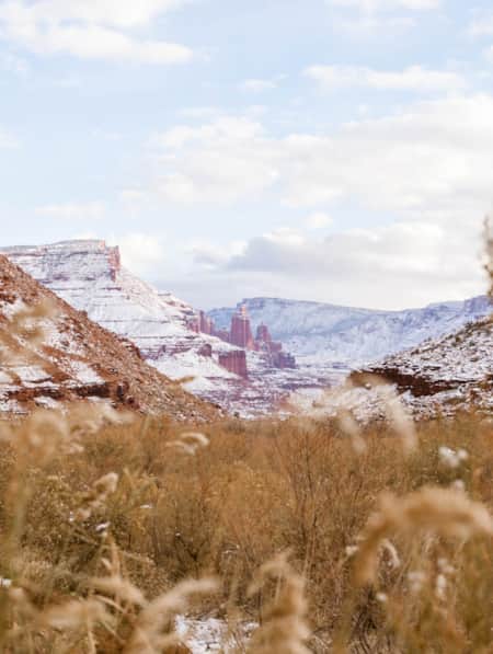
Grand Staircase-Escalante National Monument
Golden cathedral.

Why you should go : Picture beams of golden sunlight cutting through the sandstone ceiling to illuminate the tranquil pool below.
- Distance : 9.5 miles
- Elevation Gain : 1,260 feet
This is one of those rare backpacking adventures where the journey is nearly as magnificent as the destination. Starting at the Egypt Trailhead, you’ll immediately enjoy views of the Egypt Cliffs before descending into Neon Canyon. As the name suggests, Neon Canyon features a brilliant display of natural color as the sunlight and shadows dance across the sandstone walls.
Your ultimate destination is Golden Cathedral, a unique natural wonder where thousands of years of water erosion has carved three holes into the sandstone ceiling. At midday, the sunlight streams through the openings and lands on the pool below like a trio of natural spotlights.
Don’t let the Golden Cathedral Trail’s moderate difficulty fool you — this is a technical trail that requires canyon navigation skills and climbing gear to rappel down. The hydro-hike involves wading through multiple pools and possibly swimming through some sections if the water levels are high, so be sure to pack appropriately with waterproof gear.
More Information : Your Hike Guide
Death Hollow
View this post on Instagram A post shared by Catherine Gregory (@catgphoto) on Oct 31, 2018 at 3:19pm PDT
Why you should go : A hydro-hike through a deep gorge with slot canyons, waterslides, petroglyphs, and beautiful views.
- Distance : 14 miles
- Elevation Gain : 2,312 feet
The Death Hollow hike takes backpackers across McGrath Point Bench and Slickrock Saddle Bench down to the narrow depths of Death Hollow. Ignore the morbid name — this surprisingly deep gorge is one of the most dramatic canyons in the area, showcasing the raw, natural beauty of the wilderness that draws adventurers to Grand Staircase-Escalante National Monument.
You’ll spend a fair amount of time wading through pools as you navigate Death Hollow, and you may find yourself swimming when the water levels are high enough. Flash floods are deadly down here, so keep a sharp eye on the weather.
More Information : Utah Travel
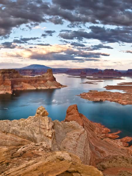
Glen Canyon National Recreation Area
Coyote gulch.

Why you should go : a gorgeous red rock canyon featuring two arches, a natural bridge, and multiple waterfalls
- Distance : 11.5 miles
- Elevation Gain : 1,840 feet
Coyote Gulch is a popular destination in the heart of southern Utah’s canyon country, accessible by quick day hikes, overnighters, and weeklong backpacking adventures.
Whichever path you choose, you’ll enjoy spectacular scenery from start to finish. Along the lazy river you’ll find a couple of arches, a natural bridge, ancient pictographs, and a number of small waterfalls.
Reflection Canyon

Why you should go : visit the most photogenic canyon in Glen Canyon National Recreation Area
- Distance : 20 miles
- Elevation Gain : 1,234 feet
If you’re an Apple fan, you may recognize Reflection Canyon as the default screensaver back in 2012. As great as it looked in full Retina color, trust us — the view is even better in person.
Reflection Canyon flew under the radar until National Geographic photographer Michael Melford published some epic photos of the canyon in 2006. It’s steadily grown in popularity since then, though the distance and challenge do a good job of keeping the crowds down.
More Information : Outdoor Project
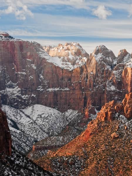
Bryce Canyon National Park
Bryce canyon under the rim trail.
View this post on Instagram A post shared by Doug (@dhadzhouser) on Jul 2, 2018 at 12:26pm PDT
Why you should go : Tackle the longest trail in Bryce Canyon National Park with epic views from start to finish.
- Distance : 23 miles (one-way)
- Elevation Gain : 2,700 feet
Bryce Canyon’s Under the Rim Trail delivers a legendary backpacking adventure through the country’s smallest national park. Whether you tackle the monstrous trail point-to-point or combine it with other trails to make a loop (the park has a great shuttle system to support both), you’ll enjoy distant views of Bryce Canyon’s famous slot canyons and hoodoos in relative seclusion.
Wildfires and trail damage have forced the park to close several portions of the Under the Rim Trail, so be sure to check the National Park Service website for closures when you’re planning your route.
Zion National Park
Trans-zion trek (zion traverse).
View this post on Instagram A post shared by Matt Morawetz (@mattynochains) on Jul 16, 2019 at 2:43pm PDT
Why you should go : An epic odyssey through Zion National Park that’s been crowned one of the most scenic trails in America.
- Distance : 48.3 miles
- Elevation Gain : 6,334 feet
Men’s Journal proclaimed the Trans-Zion Trek the most scenic running trail in America back in 2003. While we agree with the scenic part, we’re pretty confident that you’ll enjoy the journey’s stellar sights more at a leisurely pace.
You can easily break the Trans-Zion Trek into smaller day-hikes and overnighters, but the truly adventurous will begin their 50-mile odyssey at Lees Pass in Kolob Canyon. The 4-6 day journey takes you all the way from the northwest tip to the southwest corner of the park, concluding at the Echo Canyon Trailhead.
West Rim Trail
View this post on Instagram A post shared by A Stokes (@iamstokes317) on Jul 4, 2019 at 6:54am PDT
Why you should go : Descend from the highest point in Zion National Park through the White Cliffs to the photogenic Grotto in Zion Canyon.
- Distance : 16.2 miles
- Elevation Gain : 3,600 feet
If you don’t have a week to tackle the Trans-Zion Trail, check out the West Rim Trail. You can complete the top-to-bottom hike in 2-3 days, and you’ll still get to see some of the best sights in Zion National Park.
The West Rim Trail starts at Lava Point, where you’ll find a stellar viewpoint that serves as a preview for your backpacking adventure. Your journey will take you down past the White Cliffs into picturesque Zion Canyon, where you’ll find a magical desert grotto awaiting at the end of the trail.
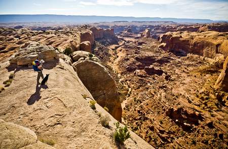
Canyonlands National Park
Big needles loop.

Why you should go : A long but mostly level loop hike through the colorful spires of Cedar Mesa Sandstone that comprise The Needles.
- Distance : 23.2 miles
- Elevation Gain : 600 feet
With much of the area only accessible by backcountry trails, you’ll find that The Needles offers the best of Canyonlands National Park without the crowds that swarm to the Island in the Sky. Thanks to a great network of interconnected trails, you can easily put together a multi-day itinerary that fits your schedule and doesn’t rely on complicated shuttle transfers.
The four-day Big Needles Loop features enough impressive sights and viewpoints to stand on its own, but the best part about this hike is the number of side trips at your disposal. If you have time to spare, consider making detours to visit Elephant Canyon, Upper Lost Canyon, Peekaboo Spring, and Chesler Park Overlook.
Harvest Scene
View this post on Instagram A post shared by Steven Foldi (@deathwithwalls) on Apr 21, 2019 at 5:51pm PDT
Why you should go : Navigate the narrow canyons of The Maze to reach one of the most famous rock art sites in the world.
- Distance : 8.7 miles
- Elevation Gain : 1,600 feet
Known for its labyrinth of narrow canyons, The Maze is the least accessible district in Canyonlands National Park. It’s been named one of the 10 most dangerous hikes in the US by Backpacker Magazine — a siren song for experienced backpackers looking for a unique and challenging desert adventure.
The Harvest Scene Hike is the only loop trail in The Maze, and it’s just the right length for an overnight backpacking trip. If you can successfully tackle the rocky labyrinth without getting lost, Harvest Scene features a miraculously well-preserved set of petroglyphs that dates back 3,000 years. ;
Bears Ears National Monument
Grand gulch.
View this post on Instagram A post shared by Nick C McMahan (@nickcmcmahan) on May 30, 2019 at 6:20pm PDT
Why you should go : An exciting hike for history buffs and archaeologists, featuring well-preserved cliff dwellings, artifacts, and pictographs of the Ancestral Puebloans.
- Elevation Gain : 1,719 feet
A hidden gem, Grand Gulch was once the best-kept secret in southern Utah. The rugged, remote stretch of backcountry is only accessible by foot, providing backpackers a level of silence and solitude that’s becoming increasingly rare on the trails.
Grand Gulch features gorgeous red rock canyons, stellar stargazing, fascinating Native American ruins, and ancient pictographs. The ruins and pictographs date back 700-2000 years and are miraculously well-preserved.
More Information : Roots Rated
Dark Canyon Wilderness
View this post on Instagram A post shared by Utahgram (@utahgram) on Jun 26, 2019 at 6:05am PDT
Why you should go : Enjoy peace and quiet on the trail as you traverse the forest and desert landscape of the Dark Canyon Wilderness.
- Distance : 40 miles
- Elevation Gain : 2,300 feet
The Dark Canyon Wilderness in Manti-La Sal National Forest offers a diverse range of scenery, featuring a mix of forest and desert landscape that’s dotted with ancient Native American ruins and petroglyphs. Backpacking the full 40-mile loop through Dark, Woodenshoe, and Peavine Canyons usually takes 5-7 days, though you can almost double that with all of the side trails at your disposal.
Owl Creek—Fish Creek Loop
Why you should go : As you explore two incredible desert canyons you’ll pass three natural arches, ancient cliff dwellings, and rock art sites.
- Distance : 17 miles
- Elevation Gain : 1,300 feet
As Grand Gulch grows in popularity, more backpackers are looking elsewhere to experience Cedar Mesa without the crowds. The Owl Creek—Fish Creek Loop is a popular alternative, taking backpackers through two deep, narrow canyons with gorgeous desert scenery, including Nevill’s Arch and two unnamed arches.
As you’re appreciating the desert scenery, keep an eye out for the Ancestral Puebloan cliff dwellings and rock art on the canyon walls.
Keep Exploring Utah
When you’re ready to swap your backpack for a daypack, check out our favorite hikes near Provo and Moab . We’ve also got the 411 on the best waterfall hikes in Utah , featuring falls from the Salt Lake area down to red rock country and everything in between. For a cushier stay in Utah, check out our favorite Airbnb rentals near Zion National Park .
More Utah Camping
14 Best Hikes Near Provo, Utah
17 Best Hikes Near Salt Lake City, Utah
15 Epic Day Hikes Near Moab, Utah
The Best Hikes at Bryce Canyon National Park
12 Best Hikes in Arches National Park
5 Incredible Backpacking Excursions in Zion National Park, Utah
Sign up for our free email to join thousands of readers getting epic travel, hiking, camping and gear ideas every week.
Seen in: Arches National Park , Backpacking , Canyonlands , Utah , Zion National Park

Posted by Mac Misseldine
Mac is a digital marketer and freelance writer based in Pleasant Grove, Utah. He enjoys exploring the countless trails that the Beehive State has to offer, though his favorite outdoor adventures involve a snowboard and fresh powder.

15 Refreshing Waterfall Hikes in Utah
Find your next adventure.
Sign up for Weekend Wanderer and join thousands of readers getting epic travel ideas weekly.
Related Posts

11 Unique Places to Stay in Utah for the Perfect Getaway
These unique places to stay in Utah may be a little pricier than your average hotel, but they'll add that certain je ne sais quoi to your Utah getaway or staycation.

6 Phenomenal Backpacking Trails in Joshua Tree National Park
A wonderland of boulders, cacti, and spiny, Seussian trees, Joshua Tree National Park is a haven for desert lovers and backpackers of all ages.

14 Best & Most Unique Airbnbs in Utah
Ready to spice up your Utah vacation? Cancel your reservation at the Holiday Inn and book a stay in one of these wild vacation rentals.

Trail Guide: Timberline Trail at Mount Hood, Oregon
If Oregon's biggest treasure is Mount Hood’s snow-capped peak, then the Timberline Trail is its shining tiara.

The 14 Best Hikes in Zion National Park, Utah
Ready for an adventure? Take on the epic hikes and sheer sandstone cliffs of Utah’s first national park.

The 11 Best Things To Do in Kanab, Utah
Kanab is the perfect basecamp tor adventures through these vast areas, and considering how much there is to do in Kanab, you could spend a whole week here, easily.

The 8 Best Camping Spots Near Provo, Utah
The mountains surrounding Utah Valley offer ample opportunities to escape the city and reconnect with nature.

15 Best Hikes Near Moab for an Epic Desert Adventure
Welcome to Moab, gateway to the epic red rock landscapes of Arches, Canyonlands, and Dead Horse Point.
Backpacking the Backcountry: 4 Fishing Trips You Need to Take
These trips offer the best of both backpacking and fishing..

These trips offer the best of both backpacking and fishing. You get the chance to see some of America’s last wild places, and fly fish in rivers and lakes that may only see a dozen anglers a year.
If there’s one thing I regret about my high school years, it’s that I didn’t take full advantage of all the backpacking trips I could’ve had. I grew up on the side of a mountain in rural Utah but never ventured too far from the peaks in my backyard. Now, even though I’m still young and spry, I don’t say “yes” to every backpacking invitation like I used to.
Apparently, years of running around the wilderness catches up and reminds you that two 10-plus mile backpacking trips in consecutive weeks will hurt . It’s a good reminder to have, if only because it pushes me to go on as many trips as possible. The day is a long way off – but approaching – when my knees won’t stop hurting.
I should note that among my circle of friends, a backpacking trip is more of a “fishing in as many remote lakes and streams as we can” trip than traditional backpacking. Any weight saved by using the lightest packs, bags, and pads is cancelled by the wealth of tackle everyone brings. I went on a trip once where a guy hauled a float tube, fins, hand pump, and waders 18 miles in the High Uintas Wilderness here in Utah.
Anyway, the point is these trips offer the best of both backpacking and fishing. You get the chance to see some of America’s last wild places, fly fish in rivers and lakes that may only see a dozen anglers a year, and have an experience that relatively few other people do.
The following list is made up of places I’ve been and a few that are still on the bucket list. Whether you’re a diehard fly fisherman and want to fish untouched water, or you’re just along for the hike, these trips are for you.

Wyoming’s Pole Creek Lakes lie at the base of the Wind River Mountains. With altitudes near 9,500 feet, the Winds offer a unique backpacking challenge that culminates in some of the area’s best trout water. Photo Credit: Spencer Durrant.
1. Pole Creek Lakes, Wind River Mountains, Wyoming
The last time I did this trip I came home with altitude sickness and an alarming realization that I’m not in as good of shape as I thought. Apparently, the kid who ran a 5:45 mile in high school is buried beneath the dad bod I’m rocking these days.
It’s a beast of a hike, at a good elevation, but it puts you on some of the best trout water in the Wind River Mountains. I was lucky enough to be in the area for the 2017 total solar eclipse, and even then it wasn’t crowded.
The Pole Creek Lakes have a ton of brookies in them, but golden trout are there if you know where to look.
The Winds are remote, beautiful, and dangerous. If you’ve never been there, haven’t spent a lot of time at altitudes above 9,500 feet, or haven’t spent much time in the Rockies in general, I’d strongly recommend a guide for the first time. Someone who knows the area, the fish, and the wildlife is invaluable in helping you have a great time.
2. Golden Trout Wilderness, California
If native trout anglers have a mecca, it’s a tie between Pyramid Lake and the Golden Trout Wilderness.
The Sierra Nevada Mountains are incredible, if overcrowded these days. The Golden Trout Wilderness, though, is remote enough to dissuade the masses.
And, there’s the perk of it being home to the Kern River, a river to which golden trout are native. When it comes to rare fish, golden trout are at the top of nearly every angler’s wish list. They don’t get as big in the Kern River as they do in other places throughout the West. It’s a bit ironic that they’re small in their native range and grow to trophy sizes elsewhere, but this is one of the few places in the world you can catch golden trout from the rivers they’ve swam in for thousands of years.

Whether you’re a diehard fly angler and want to fish untouched water, or you’re just along for the hike, a backcountry fishing trip will offer the adventure of a lifetime.
3. Wall Lake, Uinta Mountains, Utah
This is one of the most popular hikes in Utah’s Uinta Mountains. That said, Wall Lake has the space to accommodate many people. Just don’t be surprised to find the trailhead parking lot nearly full.
Wall Lake makes this list because it’s a great backpacking trip for those who just want to get some peace and quiet next to one of Utah’s more scenic lakes, and those who want to put some miles on their boots in pursuit of big trout. Wall Lake itself has a decent trout population, and it makes a great base camp for day excursions to a few dozen surrounding ponds and lakes, all of which are home to big trout.
4. Hells Canyon, Oregon/Idaho
It’s appropriately named.
Hells Canyon is the deepest river gorge in North America, with canyon walls on the Idaho border rising some 7,993 feet above the Snake River. It’s deeper than the Grand Canyon, to put it into perspective.
What makes Hells Canyon such an attraction is the sheer amount of undeveloped wilderness. A total of three roads run through the area, which leaves the rest of the river accessible only to those willing to hoof it.
This is one of the most remote areas in the country, and home to some of the Pacific Northwest’s biggest Class IV rapids. It’s also known for being a great first-of-the-year trip for backpackers, since the elevation at the river is so low.
Hells Canyon has the extremes for those who want them, and the laid-back trails for the rest. And the fishing is spectacular year-round, though it picks up more during the fall when the steelhead run.

“As much as I love backpacking, I love where it takes me more,” said writer and angler Spencer Durrant. “I think that’s why a lot of people do it, and I know it’s why I’m willing to strap 30 pounds of gear to my back and hike for miles.” Photo Credit: Spencer Durrant, taken while fly fishing the Pole Creek Lakes in Wyoming’s Wind River Mountains.
As much as I love backpacking, I love where it takes me more. I think that’s why a lot of people do it, and I know it’s why I’m still willing to strap 30 pounds of gear to my back and hike for miles. The fishing is always the main attraction, but the scenery along the way isn’t bad.
If you’re new to backpacking or backcountry fishing, I highly recommend finding a fishing guide . I can’t stress enough how helpful they can be. The backcountry, especially out here in the Rockies, is an unforgiving place. It’s not an area for rookies on their own. But with the right planning, good maps, and light packs, you’ll be able to have an unforgettable time in any of these places.

10 Best Utah Backpacking Trips
Discover the best Utah backpacking trips across the state from easy but scenic one-night trips to multi-day backcountry adventures.

Find this post helpful? Learn how you can support Bearfoot Theory’s work here . You can also shop for gear through the affiliate links in this blog post where we get a small commission at no cost to you. It helps keep our team running and the lights on. THANK YOU! -Kristen
Although Utah is most famous for its “Mighty Five” National Parks (Arches, Canyonlands, Capitol Reef, Bryce, and Zion), more than 70% of the state is classified as public land from national monuments to recreation areas to national forests to BLM areas, and the opportunities for outdoor recreation are expansive.
If you’re ready to stretch your legs on some longer multi-day hikes, here are 10 of the best backpacking trips in Utah, ranging from incredibly beautiful overnights to challenging week-long trips.

Download my FREE Outdoor Trip Planning Toolkit
Enter your email to get access to printable PDF packing checklists, itineraries, and more.
Best Utah Backpacking Trips – Mapped

1. Coyote Gulch Loop
- Location: Glen Canyon National Recreation Area
- Trail Type: Loop
- Distance: 10.6 miles
- Suggested Time: 2 days, 1 night
- Difficulty: Hard
- Permit needed? Yes
- Best Seasons: Spring and fall
If you’re in the market for a relatively short but delectably sweet overnight hike, head to Coyote Gulch , which borders Glen Canyon National Recreation Area and Grand Staircase-Escalante National Monument.
This hike can be done in several variations, up to 22 miles in length, but this 10.6-mile loop hits many of the area’s highlights including two arches, a natural bridge, and numerous waterfalls.
First, stop at the Escalante Interagency Visitor Center in the town of Escalante to pick up your permit, inquire about road conditions and get the latest weather report.
The 10.6-mile loop is accessed by driving the notoriously rutted Hole in the Rock Road to the infamously sandy 40 Mile Ridge Trailhead. Depending on the road conditions, which change from year to year and season to season, you will likely need 4WD , especially for the deep sand on the last two miles to the trailhead. If your vehicle isn’t 4WD, you may be able to start the loop from the Hurricane Wash trailhead, 33.8 miles down Hole in the Rock Road.
Coyote Gulch’s biggest draw is the miracle of water in the desert. You’ll likely get your feet wet on this hike as the route follows and continuously crosses a perennial stream to its confluence with the Escalante River. Beware of flash flood danger in late summer and avoid this hike if thunderstorms are in the forecast.

From the 40 Mile Ridge Trailhead, the first mile is a bit of a sandy slog but soon you’ll enter the Crack in the Wall, a tight 18-inch wide fissure that drops you off the edge of the mesa into the canyon.
Plan to bring a rope to lower your backpacks through this section. The best campsites are found between miles 4 and 5 and water is found throughout the canyon seeping from natural springs trickling out of the canyon walls.
To exit the canyon, you’ll need to tackle a short scramble up some ledges just past Jacob Hamblin Arch. Inexperienced hikers may find this section intimidating, but there are often fixed ropes here to help protect the climb but you may want to bring your own.
Read next: For a slightly longer one-way trail (vs. loop above), check out our Coyote Gulch Backpacking guide which covers the hike from Hurricane Wash to Crack in the Wall.
Planning information

2. Reflection Canyon
- Trail Type: Out and Back
- Distance: 15.2 miles
- Difficulty: Moderate
This adventurous overnight hike ends at one of the best sunset/sunrise spots in southern Utah, overlooking a uniquely squiggly arm of Lake Powell. This view of bright blue goosenecked bays bordered by towering Navajo sandstone cliffs was made famous by National Geographic and then Apple computers, which used an image of this vantage point in advertisements for the 2012 MacBook Pro.
You’ll need a reliable 4WD vehicle to drive the 50 miles of ruts and bumps down the Hole in the Rock Road to the trailhead. From there, you’ll need a strong sense of direction and a lot of water. There are no sources of water on this trek so you’ll need to carry enough for two days of strenuous hiking and a night of camping and cooking.
Before leaving Escalante, be sure to have the route downloaded on your favorite hiking app . Most of the route runs over slickrock and there’s no defined trail. Aim to follow the long line of cliffs on your right (west) as you hike south. If you stray too far east away from the cliffs you’ll end up in a maze of often impassable slot canyons.
About five miles from the trailhead, you’ll turn southeast to head towards the overlook. From here, you’ll be treated to magnificent views from sunset to stars to sunrise.
New to hiking in the desert?

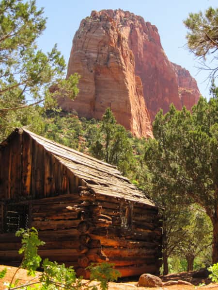
3. Lower Hackberry Canyon
- Location: Grand Staircase-Escalante National Monument
- Distance: 12.4 miles
Travel back in time to visit a historic cabin and the beautiful Sam Pollack arch on this overnight trek into Lower Hackberry Canyon.
Located at the southern end of the Cockscomb, an imposing and colorful ridge of uplifted sandstone, Lower Hackberry Canyon winds into the heart of the comb, following a beautiful creek that runs most of the year.
About four miles into the hike, you’ll reach Frank Watson’s cabin. Built in 1914 using cottonwood logs harvested on-site, this one-room cabin was restored in 2021 and is an excellent example of a 100-year-old homestead.
Intrepid hikers may also want to seek out an even older abode in the nearby side canyon: a small food storage granary, some grinding stones, and an intriguing humanoid pictograph found nearby in a hidden alcove.
After exploring the cabin and the side canyon, hike another half mile north up Hackberry Canyon to the confluence with Sam Pollock Canyon where you’ll find some great tenting options under the cottonwood trees.
Following Sam Pollock Canyon to the northwest, in another 1.5 miles you’ll reach the spectacular Sam Pollock Arch.

Read next: Heading to Kanab? Read our guide on the best things to do in Kanab, Utah to make the most of your visit.

4. Paria River to Lee’s Ferry and Buckskin Gulch
- Location: Paria Canyon-Vermilion Cliffs Wilderness Area
- Trail Type: Point to Point
- Distance: 40 miles
- Suggested Time: 4 days, 3 nights
- Permit needed? Yes (and they are competitive)
Get your fill of world-class slot canyons on this 40-mile route that starts in Utah and ends at the Colorado River in Arizona.
The Paria River is a major tributary of the Colorado, joining the Colorado River at Lee’s Ferry upstream of the Grand Canyon.
Along the way, you’ll spend two whole days in a narrow slot canyon with an optional side trip into Buckskin Gulch, one of the world’s longest continuous slots.
Permits for both the Paria and Buckskin Gulch are extremely competitive with only 20 people a day allowed into the Paria. See permit info below.
The Paria’s stunningly beautiful setting makes this a popular hike but it’s important to know that it is also extremely challenging . For much of the trek, you’ll be repeatedly crossing the creek and often wading in the water as well as dodging ubiquitous quicksand.

Spring and fall are the most desirable months but freezing water temperatures early and late season can make for miserable conditions.
In the summer, the canyon dries up and turns into a furnace while late summer monsoons can deliver deadly flash floods in these inescapable canyons.
If you manage to snag a permit during a good weather window when the Paria is running but not too high, you’ll be in for some of the most beautiful days of your life.
After leaving from the White House trailhead, the canyon begins narrowing down into its legendary slot, passing between towering red walls of Navajo sandstone.
Just after 7 miles, you’ll pass the confluence with Buckskin Gulch with a few campsites near the junction. A side trip up the narrow corridor of Buckskin Gulch is a must-do. This is one of the most beautiful and harrowing slot canyons on Earth!

Back in the Paria, you’ll continue south, following the endless twists, turns, and meanders into the ever-deepening and narrowing slot. Keep your eyes out for springs seeping from the walls. These are your best water sources, as the Paria itself is usually too silty to filter.
After more than 30 miles in the narrows, the canyon widens as it approaches its mouth at the Colorado River. Here you’ll find Lee’s Ferry, a historic crossing of the Colorado that now serves as the put-in for rafting trips into the Grand Canyon.
Read next: Get more tips for planning your adventure with our Paria Canyon Backpacking guide (which skips the Buckskin Gulch section).

5. The Boulder Mail Trail
- Distance: 15 miles
- Suggested Time: 3 days, 2 nights
Until the 1930s, the remote town of Boulder, Utah received its mail by mule, transported via the Boulder Mail Trail. Running in a fairly straight line between Escalante and Boulder, the Mail Trail crosses three major canyons and a lot of slickrock.
With precipitous drop-offs and deep water sections, the route is not for the faint of heart and it’s a wonder that the postal mules regularly traversed it with few mishaps.
The Mail Trail can be hiked in either direction but since the Boulder trailhead is almost 1,000 feet higher in elevation than the Escalante trailhead, most people hike from east to west for a net downhill hike, ending in Escalante.
Most of the route is well-cairned but you’ll want to be familiar with navigating on slickrock and have the route downloaded on your favorite hiking app before you begin.
The three major canyons, from east to west, are Sand Creek, Death Hollow, and Mamie Creek, each with its own character.
Water is usually found in both Sand Creek and Death Hollow and less reliably in Mamie. Death Hollow is the deepest and arguably loveliest of the three canyons, requiring an 800-foot descent down through Navajo sandstone benches into the canyon.
In Death Hollow, you’ll likely get your feet wet as you follow the creek for about a mile. Avoid the brushy banks as they’re often rife with poison ivy. Also, flash floods are a real danger here so be sure to check the weather before you commit to this hike.
The slickrock climb out of Death Hollow is marked by cairns and is easy to miss. The other route continues downstream to where Death Hollow meets the Escalante River.
You’ll also cross a fourth, unnamed canyon before reaching the Escalante trailhead. In total you’ll gain and lose around 2,500 feet of elevation throughout the 15-mile trek, going from Boulder to Escalante.

6. Bullet Canyon to Grand Gulch
- Location: Bears Ears National Monument
- Distance: 20 miles
More than 1,000 years ago, this complex of deep serpentine canyons in what is now Bears Ears National Monument was a neighborhood inhabited by hundreds of people.
Many generations of families made a living here by growing food and hunting wild game and living in multi-roomed dwellings, often situated under overhanging cliffs. They also created art by painting and etching the walls of the canyon.
But as the climate became warmer and dryer, resources became scarcer and people began building defensive dwellings and food storage structures high on cliff ledges, reachable by only seemingly superhuman feats of athleticism and bravery. Around 700 years ago, people left the canyon, moving into larger Pueblo communities to the south and east.
Thousands of ancient dwellings are found throughout the Bears Ears region but Grand Gulch is famous for the density and preservation of sites. Today, Grand Gulch is preserved as an outdoor museum , with many artifacts and relics left in place.
All visitors to this fragile and sacred place must follow all Leave No Trace principles , as well as additional guidelines for visiting archaeological sites, including:
Permits for this trip, which follows Bullet Canyon to Grand Gulch to Kane Gulch, are competitive and all hikers, including day hikers, need to check in at the Kane Gulch Ranger Station before exploring the area.
Water remains scarce in these canyons so be sure to check with the rangers that springs are flowing or you may need to carry water for your entire trip.

7. Under the Rim Trail plus Rigg’s Spring Loop
- Location: Bryce Canyon National Park
- Distance: 31.8 miles
- Best Seasons: Late spring, summer, and fall
Bryce Canyon is one of the country’s smallest national parks, only covering 55 square miles of land. But what the pocket-sized park lacks in size it makes up for in scenery. It boasts an incredibly colorful hoodoo spire-studded amphitheater that has been scooped out of the high-elevation Paunsaugunt Plateau.
Bryce is famous for its awe-inspiring overlooks but backpackers can get to know the park’s hoodoos, windows, and slot canyons on a more intimate level on the Under the Rim Trail.

This 23-mile trail begins at Rainbow Point in the south and runs north to Bryce Point, skirting the forested base of the plateau’s eastern edge. For bonus miles, add on the 8.8-mile long Rigg’s Spring Loop at the start of your trek.
Park shuttles connect all of the overlooks, including Rainbow Point and Bryce Point, making for easy logistics at the start and end of your hike.
Bryce Canyon reaches elevations over 8,000 feet, keeping this park much cooler in the summer months than the rest of Utah’s red rock country, which is often too hot for summer exploration. But even with cooler temperatures, water is still scarce in the amphitheater. Always check with park rangers about water availability before beginning your trek.
Some hikers elect to leave a water cache at the junction of the Under the Rim trail and the Swamp Creek connector trail. Bottles must be labeled with the hiker’s name and permit dates and must be packed out at the end of your hike.
Read next: Looking to spend more time in Bryce National Park? Check out our complete guide for more tips on the best hikes, where to stay, and things to do.

8. West Rim Trail
- Location: Zion National Park
- Distance: 14.1 miles
- Permit needed? Yes (permits are competitive)
Take the scenic footpath route into Zion via the West Rim trail. This 14-mile route starts at Lava Point in the Kolob Canyons unit of Zion, northwest of the main part of the park.
Lava Point sits at nearly 8,000 feet of elevation, while Zion Canyon dips down to 4,000 feet, making this a net downhill hike.
For the first 6.5 miles, you’ll be treated to sweeping views of Wildcat Canyon and the West Rim of Zion before beginning your descent at Cabin Spring into Zion Canyon where you’ll end at the Grotto Picnic Area.
With a little planning and a lot of luck, you could also apply for a permit to hike Angel’s Landing, which you’ll pass on your way down into Zion. A new lottery system was implemented in 2023 to limit the number of hikers on the notoriously narrow route, but it’s worth trying for a permit since it’s a spectacular hike (if you don’t mind heights!)
The West Rim’s higher elevation makes this route possible during the hotter summer months, but you should be prepared to spend part of the day in the shade and hike in the cooler morning and evening hours.
There are nine designated campsites along this route and water is usually available from several springs and natural sources along the way but be sure to check availability before you start your hike.
Read next: Need help planning your trip? Check out our West Rim Trail Backpacking Guide and our general Zion National Park Guide .

9. Mount Timpanogos
- Location: Uinta-Wasatch-Cache National Forest
- Distance: 14.3 miles
- Permit needed? No
- Best Seasons: Summer and early fall
Towering over the greater Salt Lake City metropolitan area, Mount Timpanogos , affectionately known as “Timp”, is the second-highest peak in the Wasatch Range, reaching 11,753 feet in elevation.
The 14.3-mile round trip hike to the summit gains over 4,400 feet of elevation and for many people, is best broken up into an overnight hike.
The trek begins at the Timpooneke trailhead, next to the Timpooneke campground, and follows the South Fork River past Scout Falls up into Timpanogos Basin. Most people elect to camp here, near Emerald Lake, and tackle the final climb up to the saddle and scramble along the windy ridge to the summit.
On top, you’ll be rewarded with unparalleled views of the Great Salt Lake Valley, Utah Lake and Provo Canyon. Mountain goats are often spotted on the surrounding cliffs and ridges.
Beware of lightning danger in the summer , though. It’s best to be off the summit by early afternoon to avoid thunderstorms.
This hike can also be done from the Aspen Grove Trailhead, which has a similar mileage and slightly more elevation gain, meeting the Timpooneke route near Emerald Lake.
Read next: 3-Day Backpacking Checklist
Read next: Read our Timopanogos trail guide for more tips on planning your hike.

10. Uinta Highline Trail
- Trail Type: High Uintas Wilderness
- Distance: 104 miles
- Suggested Time: 9 days, 8 nights
- Best Seasons: Summer
Utah’s most famous long-distance hike follows the crest of the Uinta Mountains, an east-to-west running mountain range in the northeast corner of the state. Along the way, you’ll tag King’s Peak, the highest point in Utah at 13,528 feet and known for being one of the most remote high points in the state.
The Highline Trai can be hiked in either direction, but most thru-hikers elect to go from east to west , starting at McKee Draw and ending at Hayden Pass near Mirror Lake.
The trail crosses eight named mountain passes, all over 11,200 feet of elevation, altogether gaining and losing over 16,000 feet of elevation.
Water abounds on this route and can be found in many small creeks and alpine lake basins and meadows. In between the passes, you’ll dip back into aspen groves and pine forests, which can give some cover during the afternoon thunderstorms that often roll across the mountains in late summer.
The hiking season can be short in the Uintas, especially in deep snow years when the passes may remain snow-covered until late July or August.
Utah is home to unlimited outdoor adventures. Here are a few more Utah blog posts to help you plan an epic trip to this incredible state:
- 9-Day Utah National Parks Itinerary
- Best Utah State Parks for Hiking and Camping
- Best Hikes in Utah: 20 epic trails
- Best Hikes Near Salt Lake City
Have you done any backpacking trips in Utah? What are your favorite trails and routes? Which of these are on your bucket list? Let us know in the comments!
Related Posts

Mary is a freelance science and travel writer. For over a decade, Mary was a roving correspondent for EARTH magazine, where her favorite beat was the Travels in Geology column. She also founded the Living in Geologic Time column for Eos magazine and her work has appeared in Science News, High Country News, and the Guardian. She also writes the popular blog Travels with the Blonde Coyote, and is the author of Aerial Geology: A High-Altitude Tour of North America’s Spectacular Volcanoes, Canyons, Glaciers, Lakes, Craters and Peaks. In her 15 years as a North American road-warrior nomad, Mary has hiked in all 50 states and visited over 200 national parks. When she’s not at the keyboard she can usually be found outside—hiking, skiing, climbing mountains, and taking photographs.
Leave a Reply Cancel reply
Your email address will not be published. Required fields are marked *
Save my name, email, and website in this browser for the next time I comment.
Amethyst Basin Backpacking Guide – High Uintas
Some of the links on this page are affiliate links

The High Uinta WIlderness is home to a plethora of great backpacking options and a hike to Amethyst Basin is among the very best. Moderately challenging, this hike takes you up to a high alpine lake with gorgeous campsites options. The trail follows the Stillwater and Ostler Forks of the Bear River as it ascends about 2050 feet, passing beautiful waterfalls on the way to a stunning cirque basin. The meadow-framed basin rewards backpackers with a glistening alpine lake with a panorama of views of Ostler and Hayden Peaks. Extra days allow time for climbing Ostler Peak or walking the entire perimeter of the lake.
QUICK FACTS
Distance : 13 miles (21 km), round-trip
Days Needed : 2-4 days (depending on itinerary add ons)
Elevation Gain/Loss :2,050 feet (625 m)
Peak Elevation : 10,740 feet (3,273 m)
Best Travel Time :July – October

Wildlife, including elk, mule deer, black bear
Fascinating geology
Beautiful lake, waterfalls and rivers
Heavy coniferous forest canopy
Beautiful meadows and wildflowers
Well-maintained trails
Dogs allowed
High-country lake fishing
Muddy and rocky trails
Armies of mosquitos and horseflies, but also ticks and yellow jackets
Cold lakes makes swimming tempting, but challenging
Giardia and campylobacter are prevalent in the streams and lakes
Busy on weekends

BEST TIME TO TRAVEL
Surrounded by high desert, the Uintas normally receive about 40 inches of precipitation annually—mostly snow. If you hike during summer months above 10,000 feet, daytime highs rarely reach above 80 degrees, while night temperatures during summer range between 30-40 degrees. Afternoon thunderstorms are fairly typical. Below treeline, summer temps range from mid-70s to the mid-90s during the day with nighttime temps rarely dipping below 40.
August is the busiest month for backpacking in the high country (to the basins). Some years June and October are dry and pleasant, but be advised that fast furious storms could arise in a hurry anytime. And lightening is a serious threat above treeline.
For local weather information below treeline, check the National Weather Service for the Uintas.
We rate most backpacking trips in this area as moderate. As always, difficulty ratings depend on the route you choose, experience, physical fitness, pack weight, and weather conditions. Although most routes in the Uintas are not technically demanding, you should always plan thoroughly, train properly, know your limitations, brush up on your skills , and dial in your gear . Doing so will make for a more safe and enjoyable adventure.

There is a $6 fee to travel Mirror Lake Highway for 3 days, free if you have an annual Mirror Lake Hwy or American Fork Canyon pass, or an annual National Park Pass . Make sure you hang your pass in your windshield at the trailhead (even in overflow parking) or you will get ticketed. No backcountry permit is required.
For more information contact the Uinta-Wasatch-Cache National Forest, Kamas office at (435) 783-4338 or the Evanston office at (307) 789-3194.
You’ll begin the hike to Amethyst Lake at the Christmas Meadows Trailhead .
From Salt Lake City, head east on I-80 through Parley’s Canyon. Just past Kimball Junction, take exit 146 for HWY 40. Drive another 3.5 miles and take exit 4, Kamas. At the first light in town, turn left. At the Chevron Station, turn right on to the Mirror Lake Highway. Drive 46 miles until you see the sign for Stillwater Campground. The unsigned turnoff for Christmas Meadows is 0.2 miles past the Stillwater Campground sign, to the right. You’ll immediately be on a dirt road signed UT 150. Travel 4 miles to the parking lot and trailhead.

Second meadow on your way up to Amethyst Lake
Small pond after the second meadow
BR-24, about 1 mile at the end of the long meadow before you get to the lake (protection from the wind and fewer mosquitos).
At the far end of Amethyst Lake below the peaks
POSSIBLE ITINERARIES
Two day itinerary.
STARTING TRAILHEAD: Christmas Meadows ENDING TRAILHEAD: Christmas Meadows
Day 1 – Hike from Christmas Meadows to campsites on the far end of Amethyst Lake below the peaks Day 2 – Return to Christmas Meadows
TOTAL MILEAGE – 12-13 miles (depending on where you camp)
Three Day Itinerary
Day 1 – Hike from Christmas Meadows to campsites on the far end of Amethyst Lake below the peaks Day 2 – Hike around Amethyst Lake or climb as far up Ostler Peak as you feel comfortable. Day 3 -Return to Christmas Meadows
TOTAL MILEAGE – 14-16 miles, depending on itinerary add ons
Four Day Itinerary
Day 1 – Hike from Christmas Meadows to campsites on the far end of the lake below the peaks Day 2 – Hike 11 miles to Ryder Lake, camp Day 3 – Hike 11 miles back to Amethyst Lake, camp Day 4 – Return to Christmas Meadows
TOTAL MILEAGE – 36 miles

MAPS & GUIDEBOOKS
Hiking Utah’s High Uintas: A Guide to the Region’s Greatest Hikes by Brett Prettyman, an outdoors editor for the Salt Lake City Tribune. This guide includes descriptions of 99 routes throughout the backcountry wilderness of Utah’s Uinta Mountains and High Uintas Wilderness, including easy day hikes to great fishing spots, adventurous treks to remote campsites, and extended backpacking trips for intrepid wilderness travelers.
National Geographic High Uinta’s Wilderness Trails Illustrated Map This map covers the High Uintas Wilderness, as well as the Ashley and Wasatch-Cache National Forests. It features key points of interest and is printed on “Backcountry Tough” waterproof, tear-resistant paper. A full UTM grid is printed on the map to aid with GPS navigation.
60 Hikes Within 60 Miles: Salt Lake City by Greg Witt. This book includes many of the best hikes in the Western Uintas with detailed trail descriptions that range from easy strolls to challenging backpacks. Extensive key-at-a-glance information makes it easier to choose a hike based on length, difficulty, or scenery.
High Uintas Backcountry by Jeffrey Probst This trail guide travels the length of the Uintas with descriptions on 99 hikes, 600 fishable lakes, and over 400 miles of streams. Each story includes a trip planner, photo, and map. The appendix includes full maps of all areas, a campground and trailhead directory with directions. There are over 200 photos and maps.
Gaia Phone app GPS and Caltopo Mapping Software – We use both these services for many of our backpacking trips to assist with route planning (Caltopo) and on-trail navigation (Gaia).
Water is plentiful along the trail to Amethyst Basin and accessible from small streams and lakes. Though many sources look pure, Giardia and Campylobacter are present in this area so we recommend using a lightweight water filter (here’s a list of our faves ). We carried the MSR Trail Shot on our most recent trip and were happy with its performance. Two other good lightweight options are the SteriPen Ultra and Aquamira Drops . Check out our best water filters list for more excellent options.

REGULATIONS
For a full list of wilderness regulations in this area, visit this website . But in, general, the following apply:
Stay on designated trails and do not cut switchbacks.
Select a campsite 200 feet from trails or streams.
Wash yourself and dishes away from water sources and only use biodegradable soap when necessary.
Bury human waste and fish entrails 6-8″ deep and 200 feet away from water sources.
CRITTERS & FOOD STORAGE
Black bears are not a problem in this area so there are no food storage requirements. That said, you should always protect your food against rodents and small critters, which actually tend to cause many more problems than bears. We recommend packaging all your food and scented products in a food storage container such as an Ursack .
Mosquitoes are present along this route and can be pretty vicious, especially early in the season and near bogs and water sources. Hiking later in the season is often bug-free. Use a combination of permethrin on your clothing and bring a small bottle of DEET for exposed skin to provide full protection.

BACKPACKING GEAR
We prefer lightweight backpacking because it’s more comfortable and it allows us to cover more ground with less effort. For recommendations on our favorite lightweight backpacking equipment, check out the CleverHiker Gear Guide and Top Picks page.
What to Pack
TENT: We used the Big Agnes Copper Spur HV UL3 tent on this trip for its lightweight livability. The Copper Spur is a top pick on our best lightweight backpacking tents list .
BACKPACK: We used Hyperlite Mountain Gear’s Southwest 2400 backpacks on this trek. The Southwest is incredibly lightweight, durable, nearly waterproof, and is a top pick on our best lightweight backpacks list .
SLEEPING BAG: We used the Feathered Friends Egret UL 20 and the Western Mountaineering UltraLite sleeping bags on this hike for night time temperatures right around freezing. Both sleeping bags are lightweight, warm, and make our list of the best backpacking sleeping bags .
SLEEPING PAD : We used the Therm-a-Rest NeoAir XLite and NEMO Tensor Insulated sleeping pads on this trip. Both are light, comfortable, warm, and make our list of the best backpacking sleeping pads .
COOKING SYSTEM: We used the BRS Stove , Snow Peak Mini Solo Cookset , and Snow Peak Folding Spoons on this hike, all of which make our top picks gear list and best lightweight stove list .
WATER PURIFIER: We used the MSR Trail Shot as our main purification method on this trip. It’s lightweight, affordable, and makes our best water purifiers list .
SHOES OR BOOTS: We wore Saucony Peregrine 8 trail runners ( men’s and women’s ) on this trail and they were excellent. If you prefer boots, make sure they’re lightweight and break them in really well before your trip. Here’s why we prefer hiking in trail running shoes: 5 Reasons to Ditch Your Hiking Boots . Also, here’s our list of the best backpacking shoes and boots .
HEADLAMP: A small headlamp like the Petzl Actik is an affordable, bright, and lightweight option. We’re big fans of ours.
FOOD: You’ll have to carry all the food you’ll need on this trip. Check out our Best Lightweight Backpacking Food Guide and our Best Freeze Dried Backpacking Meals for some of our go-to grub recommendations.
Here are some of our favorite hiking/backpacking clothing items from our Top Gear list .
1 Rain jacket shell – Patagonia Storm Racer / Rab Kinetic Plus
1 Pair rain pants (optional) – Mountain Hardwear Stretch Ozonic
1 Down jacket – Patagonia Micro Puff Hoody & Montbell Plasma 1000
1 Fleece jacket – Extra warmth under your down jacket that will be warmer when damp and better to hike in.
1 Pair hiking pants: PrAna Zion Stretch or running tights
1 Pair hiking shorts – Nike dri fit running shorts
1-2 Hiking t-shirts – Nike dri fit t-shirts
1 Long-sleeve shirt – Nike dri fit quarter zip
1-3 Pair underwear – ExOfficio boxer briefs or ExOfficio women’s briefs
2-3 Pair socks (add thin sock liners if using boots) – Balega running socks for warm weather & SmartWool mountaineer socks for in camp and on snow.
1 Pair long john bottoms and a long john top for nighttime use (optional).
1 Warm fleece hat
1 Pair fleece gloves or mittens
1 Pair rain mitts for wet trips (optional)
MAP &COMPASS: Although the trails here are well-marked, you always want to hike with a good map and GPS system, such as Gaia GPS . For our trip, we hiked with the National Geographic High Uinta’s Wilderness Trails Illustrated Map and used the route description provided in Hiking Utah’s High Uintas: A Guide to the Region’s Greatest Hikes . In addition, we always hike with a lightweight compass .
FIRST AID KIT: Always bring a small personalized first aid kit. We use the Ultralight .7 Kit and add extras, like painkillers and personal medications.
SUN PROTECTION: Sunglasses (polarized recommended), sunscreen, and spf lip balm are an absolute must for every backpacking trip.
POCKET KNIFE: We brought along a small Swiss Army Knife , which came in handy here and there.
OTHER ITEMS:
SMALL TOWEL: the Nano pack towel is great.
CASH and ID
PERSONAL TOILETRIES
HAND SANITIZER: Always apply after using a bathroom and before eating.
WET WIPES: These can be useful for cleaning up after hiking.
INSECT REPELLANT: Use a combination of permethrin on your clothing and bring a 1oz bottle of DEET for exposed skin to provide full protection.
CAMERA: The Sony RX100 is our go-to camera for lightweight backpacking
Amethyst Basin Photo Gallery

More Information
We hope this guide helps you plan a fantastic backpacking trip to Amethyst Basin. As always, please leave a comment below if you have any recommendations, questions, or suggestions. And if you found this guide helpful, click the little like button below to give us a digital high five!
For more popular CleverHiker content, check out the following links:
CleverHiker Gear Guide
CleverHiker Top Gear Picks
Essential Trail Skills Videos
Lightweight Gear Foundations Videos
Some of the links on this page are affiliate links, which means we may receive a small commission if purchases are made through those links. This adds no cost to our readers and helps us keep our site up and running. Our reputation is our most important asset, which is why we only provide completely honest and unbiased recommendations.
2-FOR-1 GA TICKETS WITH OUTSIDE+
Don’t miss Thundercat, Fleet Foxes, and more at the Outside Festival.
GET TICKETS
BEST WEEK EVER
Try out unlimited access with 7 days of Outside+ for free.
Start Your Free Trial

What’s the best three- to four-day backpacking route in Utah?
My friends and I are planning a backpacking trip to Utah, but we're at a loss as to where to go. We're looking for a three- to four-day trip, so something in the range of 18 to 25 miles or so, give or take. If possible, we'd love to spend some time in slot canyons, but that's not really the focus. Landon H. Boulder, CO

Heading out the door? Read this article on the Outside app available now on iOS devices for members! >","name":"in-content-cta","type":"link"}}'>Download the app .
A reputation for miles of salt flats159 to be exactmight deceive any traveler from thinking much else exists in Utah besides buoyant lakes and world-class skiing. But south of Salt Lake City are a whopping five national parks (Bryce, Zion, Arches, Canyonlands, and Capitol Reef) and a national recreation area (Glen Canyon) as well as other surreal and alluring landscapes that fall within the National Park Systems. Predominantly surrounded by sandstone, the region has been carved over millions of years by rains and rivers, forming famed monuments such as the Delicate Arch and a majority of the slot canyons common throughout Utah’s southern region. Such dramatic views make for ideal backpacking over hundreds of miles of trails throughout the desert landscape. Here are a few that make those miles all worthwhile.
Under-the-Rim Trail

Serious backcountry hiking means often going without seeing another soul on the trail – unless it’s another backpacker, of course. Bryce Canyon National Park is a 56-square-mile natural amphitheater with an expanse of limestone canyons and spires, or “hoodoos.” Check out the crowd-choked overlooks, then leave the people behind by dropping onto the Under-the-Rim Trail, which you can follow from 8,250-foot Bryce Point to Rainbow Point for 22.9 miles along the Paunsaugunt Plateau, with panoramas of natural amphitheaters, ponderosa forests, and alpine meadows. Highlights of this backcountry adventure include the Hat Shop (boulders perched atop dirt pedestals), a tilted plateau at Swampy Butte, the Natural Bridg,e and a 2.9-mile hike to the views from Rainbow Point at the end. Total elevation gain is approximately 1,500 feet with numerous climbs and descents along the way. Six campsites mark the trailRight Fork Yellow Creek, Yellow Creek, Sheep Creek, Right Fork Swamp Canyon, Swamp Canyon, Natural Bridge, and Iron Spring. Water sources are limited, and packing in a gallon per day per person is recommended. Bryce Point is accessible via shuttle during summer months. Permits are available at the visitor center and start at $5. But one thing to keep in mind: this is an out-and-back trail, not a loop. So either arrange for a shuttle, or be ready to hoof it to the nearest park bus stop after the hike. There’s also a fair amount of spill outs onto the main, paved canyon road if you end up wanting to cut the trip short (sometimes the Utah sun can be unforgiving!).
For a backcountry hike that offers both outlandish obstacles as well as funky rock formations, the trail from Coyote Gulch to Hurricane Wash in Glen Canyon National Rec Area satisfies. With two arches, a natural bridge, and several waterfalls, this 26-mile trail has become the site’s most popular. Start the hike at Red Well trailhead and you’ll get top-notch scenery not to mention quicker access to water. Beginning as a wide, sandy wash and narrowing to a canyon with towering walls, Hurricane Wash joins the lush riparian zone of Coyote Gulch approximately five miles from the trailhead. Hikers will conquer the first obstacle at Cliff Arch after reaching the second waterfall. Below the arch, daredevils can follow a ledge along the south wall about 100 feet downstream to find an opportunity to descend from the narrow footing. The next adventure is an nearly-impassable boulder jam located approximately half a mile up Coyote Gulch from the Escalante River. To navigate the boulders, follow the trail on the right side of the stream across the lower portion of a sand slide and then slowly descend the steep slickrock slope. Hike from Fortymile Ridge to Crack-in-the-Wall and scramble through the crack to a steep sand dune and lower Coyote Gulch. Just be prepared for the steep hike back up. You’ll also encounter Lobo Arch, Coyote Natural Bridge, and Stevens Arch along the way. Contact the visitor center in Escalante for permit information and weather conditions.
Zion National Park is next door neighbor to Bryce Canyon, and at 229 square miles just 15 miles long. While backpackers won’t find many common backcountry “trails,” they will find a uncommon hike along the Zion Narrows. Carved by the Virgin River, the Narrows is a 16-mile gorge in upper Zion Canyon with 2,000-foot high sheer sandstone walls, caves, and hanging gardens. The river is your guide as well as 60% of the trail, so special preparation (such as water proof sandals) is required for this unique adventureand also one of the reasons the hike was ranked #5 on National Geographic ‘s list of America’s Best 100 Adventures. Hiking from top to bottom will take you through “Wall Street,” a two-mile section where walls close to just 22-feet wide at the top of the canyon. Natural springs and waterfalls abound, and be prepared to hike waist-deep through the water or opt to take a swim along the route. Only 11 overnight campsites are available in the Narrows, so make sure to call ahead and obtain a permit. The final leg of the Narrows ends at the Temple of Sinawa where you can catch the park shuttle back to the visitor center. Before planning your trip, make sure to contact the Zion Canyon Visitor Center to obtain a backcountry permit and check weather conditions. This unique area is also a hot spot for flash flooding due to tight canyon quarters and thunderstorms that often occur miles upstream. The hike itself is open and passable Nov-May, but the cold water requires wearing a wet or dry suit, while March to early June calls for high water because of spring snowmelt; the best time to hike would be mid-summer through fall. But with proper planning and attention to surroundings, the Narrows can be a 16-mile hike like no other. Amy A. Clark
- Adventure Adviser
- Zion National Park
Popular on Outside Online
Enjoy coverage of racing, history, food, culture, travel, and tech with access to unlimited digital content from Outside Network's iconic brands.
Healthy Living
- Clean Eating
- Vegetarian Times
- Yoga Journal
- Fly Fishing Film Tour
- National Park Trips
- Warren Miller
- Fastest Known Time
- Trail Runner
- Women's Running
- Bicycle Retailer & Industry News
- FinisherPix
- Outside Events Cycling Series
- Outside Shop
© 2024 Outside Interactive, Inc
- Things To Do
Backpacking
Keep Utah Forever Mighty Stay Safe & Leave No Trace
8 Fan-Favorite Backpacking Trips in Utah
1. lake blanche trail , 2. big needles loop in canyonlands, 3. west rim trail of zion, 4. red pine lake trail, 5. dark canyon wilderness trail, 6. lone peak via lake hardy.
This 12 mile point-to-point trail starts in Alpine, Utah and ends at Bells Canyon (near Sandy, Utah) on the Little Cottonwood Canyon side. Lone Peak via Lake Hardy is an overnight backpack through the heart of Utah’s first congressionally-designated wilderness.
7. Egypt Road
Near Escalante, the Egypt-Twentyfive Mile Wash takes backpackers on a 20-mile loop through a desert canyon of slickrock, sand and wash bottoms. Plan on a 2-day minimum, but 4 or 5 days for a more leisurely exploration.
8. Owl Canyon
Another backpacking trip near Blanding, the Owl Creek-Fish Creek Loop, Cedar Mesa is a multi-day trip through two desert canyons. Spy three arches, rock art and ancestral cliff dweelings along the strenuous 17-mile loop.
"I was to look around me as though I had never been in this place before. And slowly, my travels began to bear fruit."
– Alain de Botton, The Art of Travel
BACKPACKING REGIONS IN UTAH
Backpacking Utah's Red Rock Country
Southern Utah has some of the best backpacking around. Explore more information here and plan your trip. Visit Utah.
Uinta Mountains Backpacking: Northeastern Utah
Blue-ribbon backpacking is abundant throughout the High Uintas Mountains.
Wasatch Range Backpacking
Here are a few of the best backpack trips in the Wasatch Mountains.
Showing 0 of 0
Backpacking Tips and Tricks
There is no more varied place in the world than Utah to backpack. Here are a few tips to help get you in the right mindset for backpacking in Utah.
- The season can determine the destination, whether you choose to head for the mountains, make a pilgrimage to the desert, or both.
- Two-thirds of Utah is public land: Five national parks , nine million acres of national forest , millions of acres within national monuments and national recreation areas , and vast areas managed by the Bureau of Land Management.
- Regardless of where you choose to hike, keep safety in mind and be cautious.
- Never hike alone, always tell your friends and family where you are going and when you plan to return. Learn more about how you can support Utah’s local search and rescue teams with a Utah Search and Rescue Assistance card .
- Always carry plenty of water in both the deserts and mountains, no matter the season, no matter the outside temperature. You are hiking at high elevation.
- Bring a first-aid kit and a water filter. It's a good idea to take more food and water than you think you'll need in the event you become stranded.
- Be prepared to be truly self-reliant.
- Most importantly, have a safe, fun, and rewarding experience.
The Seven Leave No Trace Principles
- Plan ahead and prepare.
- Travel and camp on durable surfaces.
- Dispose of waste properly.
- Leave what you find.
- Minimize campfire impacts (be careful with fire).
- Respect wildlife.
- Be considerate of other visitors.
- Learn more here .
Lonesome Wilderness in the High Uintas
Discover more.
Previous Group Next Group
3 Hikes That Showcase the Raw, Dramatic Beauty of the High Uintas Wilderness
Written By Matcha
Utah’s High Uinta Wilderness displays some of the most impressive and classic Rocky Mountain beauty that Utah has to offer. Here are three of the best trails to experience this rugged part of Utah for yourself.
6 Steps to a Family MTB Trip on Canyonlands' White Rim
Written By Kristen Bonkoski
2 minute read
Want to take the family mountain biking on the White Rim Trail? Tackle 100 miles of biking and three days of backcountry camping in Canyonlands with the kids.
A First-ever Camping Trip on BLM Lands
Written By Sara Hobbs
As a new resident of the western United States, I’ve discovered the gift of recreating on public lands. Though daunting at first, after researching and waiting too long, the time finally felt right to try camping on BLM lands in Utah’s dinosaur country. There is no shame in trying something new.
A Visitor's Guide to Zion's Kolob Canyons
In the Kolob Canyons section of Zion National Park, you’ll find a scenic wonderland with an adventure for everyone. Learn more about this unforgettable attraction and plan a visit.
Across a Snow-Covered Desert
5 minute read
Follow this itinerary for a week-long winter road trip across the snow-covered desert of Southeastern Utah.
Backpacking: Start 'Em Early
Written By Tim Sullivan
Follow a father and his seven-year-old daughter on her first-ever backpacking trip at the Red Cliffs Desert Reserve.
Dog-Friendly Utah: The Road to Mighty
Written By Visit Utah
7 minute read
Want to bring your furry friend on your next vacation? Utah is home to several great dog-friendly national parks and other fun destinations. Check it out and plan your trip!
Escalante River Canyon Trail
4 minute read
Located in the Grand Staircase-Escalante National Monument, the Escalante River Canyon river trail winds and knots its way east and south.
Exploring Utah's Little Sahara
Little Sahara Recreation Area is an unforgettable destination for sand dunes in Utah and ATV, camping, hiking, and sand-boarding enthusiasts.
Fishing Fish Lake
The largest natural mountain lake in Utah, Fish Lake sits at more than 8,800 feet of elevation, which makes for pleasant weather all summer long. Located near Richfield, Utah, the lake has everything you need for a relaxing summer getaway.
How to Camp on Utah’s BLM Lands
Read these insights and tips gathered from a novice’s first-ever camping trip on BLM and public lands to gain the confidence you need to recreate happily and respectfully on Utah’s public lands.
How to Take a Kayak & Camping Trip at Yuba State Park
Pristine sandy beaches, warm water temperatures all summer long and serene mountain views make Yuba State Park an appealing destination for campers and kayakers in sunny Central Utah.
Knobby Tired Nomads: Bikepacking the Utah High Country
Written By Kurt Gensheimer
10 minute read
If you’re into bikepacking, Utah is a place you’ll want to check out. Read about a self-supported tour of Utah’s backcountry here, and start planning your trip.
Meet the Fremonts: Unearthing an Ancient Civilization
Written By Andrew Dash Gillman
Did you know that interstate highway construction created Fremont Indian State Park? Visit the park and Museum for a peek into Utah’s past, plus hiking and ATV trails.
Moab Under Canvas: Glamping
If you’re looking for a luxurious camping experience, Moab Under Canvas is just the ticket. Book your stay in a fully-furnished canvas tent in canyon country!
Paddle Among Red Rocks and Waterfalls at Gunlock Reservoir State Park
Pack up your gear and head out to Gunlock Reservoir near St. George. Bring your SUP, kayaks, jet skis and power boats for a day full of watersport excitement.
Planning Ahead for Your Utah Adventure: Outdoors Tips for Three-Season Fun
Written By Austen Diamond
3 minute read
Before you plan your Utah outdoor adventures, check out our guide to proper preparation. You’ll enjoy your action-packed travels even more. Read now!
Reef Walking, Petroglyphs and Bones
Check out the world’s densest concentration of dinosaur bones at Cleveland Lloyd Dinosaur Quarry and explore other prehistoric wonders around Utah.
San Rafael Swell Throughout the Seasons: 4 Reasons to Visit
From narrow slot canyons to grand sweeping vistas, sandstone plateaus to meandering rivers, San Rafael Country and the San Rafael Swell are home to some of the most spectacular scenery in Utah.
Southwestern Utah's Legendary Panoramas
Wondering where to take pictures in Utah? Our guide to the most breathtaking Utah panoramas is only a click away. Plan a photographic getaway today!
The Story of Starvation Reservoir
Sprawling waters and local legends at Fred Hayes State Park at Starvation.
Touring the Sheep Creek and Spirit Lake Scenic Backways of Flaming Gorge National Recreation Area
Explore the Utah Sheep Creek backways within the Flaming Gorge National Recreation Area. Experience awe-inspiring scenery, rock formations, and wildlife.
Utah’s Scenery Offers A Backdrop for Inclusive Family Camping
Written By Nushin Huq
While Utah is known for its amazing outdoors, it also has resources that ensure that families and individuals of all abilities can access these places.
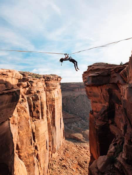
Walking The Line Between Risk and Responsibility
Written By Chelsea Yamase
Why a Hawaii-based highliner and influencer hasn't returned to Utah — yet.
Winter Wonders in Greater Zion
As you’re mapping out your winter trip through southeastern Utah, consider adding the following parks and natural wonders to your itinerary.
REI's Introduction to Backpacking blog series, to get you started and get you going
U.S. Forest Service "Know Before You Go" Hiking and Camping
U.S. Forest Service Backpacking [PDF]
Leave No Trace 7 Principles for enjoying the natural world
Summitpost.org , for monitoring conditions on peaks
BasecampMD with important information about hiking at altitude
Backpacker.com for stories, resources and gear review
Permit Information
Bureau of Land Management
U.S . Forest Service
Well-prepared travel is responsible travel.
Do your part by planning ahead

Backpacking Flyfishing Adventures
Exploring Utah’s High Uinta mountains with WRFG
The Uintas are a unique group of mountains that run east to west and include Kings Peak — Utah’s tallest peak at 13,586 ft. This breathtaking region is home to one of the most diverse fish populations in Utah. Species include brook trout, tiger trout, rainbow trout, Colorado River cutthroat trout, Bonneville cutthroat trout, golden trout and Arctic grayling. We are excited to share this remote, untrammeled playground, while sharing our knowledge of backpacking, flyfishing, camping and love for the outdoors with you and your group.
important info
There is a thorough screening process before we book our backpacking trips to assure that every one is safe and in good physical condition. All of our trips are at high altitude and some include steep terrain.
We have trips and routes available to accommodate most backpackers from moderate/easy all the way to very strenuous.
We provide all gear needed for the trips except for hiking boots, personal clothing and hygiene necessities.
Our gear is always new and top of the line from companies we trust in the outdoor industry.
Call us today and we can help get you on the right trip to fit your needs and abilities!
$2,150 – 2 Days / 1 Night
$3,190 – 3 Days / 2 Nights
$4,230 – 4 days / 3 Nights
$5,270 – 5 days / 4 Nights
Pricing includes 2 backpackers
2 additional backpackers – $600 per day
F &S Music Fest & Outdoor Expo Tickets Are On Sale Now! J oin Eric Church, Lainey Wilson & more for a party in the woods. Get tickets
FIELD & STREAM+
- Join 1871 Club
5 Can’t-Miss Backcountry Trout-Fishing Expeditions
Get off the grid and catch truly wild trout this summer
By Sage Marshall | Published May 27, 2021 12:00 PM EDT

Finding solitude on remote rivers and lakes that are full of fat—and hungry—wild fish is what trout fishing is really all about. While you might spend most of your time fishing easily-accessed waters near home, it pays to hoof it into the backcountry once in a while in search of wild trout. The following public-land trips aren’t for the faint of heart, but for the angler willing to brave the elements, they’re more than worth it.
Some of these areas can be accessed on long day trips, but you’ll probably want to spend several days fishing to make the trip worth it. Consider backpacking or using a pack animal to bring both your fishing and camping equipment with you. Pack as light as you can without skimping on your tackle. There’s nothing worse than realizing you’re getting skunked miles into the boonies just because you neglected to bring the right lures or flies with you. Instead, come fully prepared—and then get after it.
1. Golden Trout Wilderness, California

Get in on a modern-day gold rush in California’s 304,000-acre Golden Trout Wilderness . The wilderness area is located on the Kern Plateau at the Southern end of the Sierra Nevada mountains—only a couple of hours drive inland from Los Angeles. Don’t let the close proximity to this metropolis fool you, this large span of uninhabited land is a haven for golden trout, a subspecies of rainbow trout native to California. Golden trout don’t grow very big, but they’re exceptionally beautiful, making catching a golden trout a bucket list endeavor for fly and spin anglers alike. There are hundreds of trails that zigzag through the wilderness area. They give anglers the ability to find solitude on countless lakes as well as the North and South Forks of the Kern River. All fishing is catch-and-release—Golden Trout rarely get big enough for eating anyway. Permits are required for all overnight visits and are available at the Inyo National Forest ranger station .
2. Upper Raven Fork, North Carolina
You’ll find fat brookies in the Upper Raven Fork, which is a remote but productive watershed in the Great Smoky Mountains National Park . Access to the Raven Fork requires several miles of hiking, and it’s best to reserve this place for multi-day adventures. The stream was closed to fishing for almost 30-years as part of a broader effort to restore native brook trout populations in the Great Smoky Mountains National Park—and the efforts paid off. Nowadays, anglers report routinely catching big brookies. Expect pocket-water fishing with gin-clear water, small waterfalls, and deep pools. As with all small stream fishing, stealth is a must. Don’t be surprised if you hook into a few rainbows, which also haunt the stream. If you want a change of scenery, leave the Upper Raven Fork and explore the 800-miles of streams that contain fish in the rest of the National Park.
3. Frank Church River of No Return Wilderness, Idaho

The Frank Church River of No Return Wilderness is a vast span of truly wild land in central Idaho. The massive 2,366,757-acre wilderness area is the largest contiguous wilderness area in the lower 48. Its sheer size promises anglers solitude in a rugged landscape featuring steep mountains, deep canyons, and superb fishing. Anglers can target big trout in the Salmon River Canyon, which is deeper than the Grand Canyon. Floating 104 miles of the Middle Fork is a bucket-list trip, but you’ll also find plenty of fishing elsewhere, from small streams to high alpine lakes. You could spend a lifetime fishing the Frank Church without running out of new fishing holes.
4. Bridger Wilderness, Wyoming
Bridger Wilderness is a cutthroat trout haven that encompasses 2.25-million acres in central Wyoming. Amid countless 13,000-foot-high peaks in the Wind River Mountain Range, there are over 2,300 lakes in the wilderness area spread over 80-miles along the western slope of the Continental Divide. That’s so many lakes that people have lost track of which lakes actually have fish in them. There are several well-known fishing hotspots, but the real fun comes from charting an expedition to explore remote lakes that might not have been fished in years. You’ll find wild rainbows, cutties, brook trout, and even golden trout. And because of the abundance of bug life, the goldens in the Wind River Range can reach over 16-inches—which is significantly larger than they do in their native territory in California. Good navigation skills are of utmost importance in this remote region of wilderness as are common sense precautions required for traveling in a landscape replete with grizzlies and gray wolves.
Read Next: 9 Ways to Find Unknown Fishing Hotspots
5. Gunnison Gorge National Conservation Area, Colorado

The Gunnison Gorge National Conservation Area is hands-down one of the most scenic and angler-friendly stretches of water in the continental U.S. The BLM area spans 62,844 acres of public land that’s just downstream of the Black Canyon of the Gunnison National Park. The river is notoriously difficult to access. High-clearance 4-wheel-drive vehicles are required to get to three different trailheads, all of which require over one mile of hiking to reach the water. The river is small enough to wade but several local outfitters run multi-day float fish excursions that require packing supplies into the canyon by mule and running class 3 and 4 rapids. The river is known for its 20-inch-plus rainbows but also boasts impressive browns. Fly anglers will especially appreciate the giant stonefly hatch in early June, but good fishing can be found year-round for those willing to put in the work to reach the water.

Sage Marshall joined Field & Stream as an editorial intern in 2018, when he worked at the publication’s former office in Manhattan. His desk-mate was a mounted warthog. After graduating from college, he worked as a freelance journalist for two years before returning to the F&S team full-time in 2021 as the brand’s News Editor.
Want More of the Great Outdoors?
Stay adventure-ready with outdoor news that keeps you informed, not spammed.
- Sleep Systems
- Trekking Poles
- Camp Kitchen
- Accessories
- e-Gift Cards
- Backpacking 101
- Expert Articles
- Returns & Exchanges
- Search by Map
- Browse List

Top 8 Backpacking Trails in Southern Utah
Southern Utah is arguably the most scenic area of the state. It is home to 7 state parks, 5 national parks, and many national monuments, forests, and rec areas. This area boasts the largest concentration of slot canyons and natural arches in the world. Arches National Park alone has over 2,000 documented ones. With all these unique geological features, it's no wonder that so many people flock to this region for hiking, backpacking, and general sightseeing.
Today, we're looking at some of the best southern Utah backpacking trails to get up close and personal with these natural wonders.
Featured Photo: Reflection Canyon Sunrise by Ken Xu
Canyonlands-Needles District
Looking to make the most of your time at Canyonlands National Park? This 32-mile, 3-day loop is your best bet. Plus, you won't have to worry about spotting a car or setting up a shuttle! This trip is leisurely, allowing for extra time to explore. The path takes you past several geological highlights, including Devils Kitchen and Druid Arch. You can also add a spur to Peekaboo Arch. (Just a few miles extra.) On top of that, you'll hike through a different canyon each day. So, the scenery is always changing!
Camping is allowed in designated areas only. Make sure to get your reservations early. A good map is also highly recommended. For more details, head over to our detailed Hike of the Week: Canyonlands article .

Coyote Gulch Loop
Located in the Glen Canyon Rec Area, this short 13.5-mile trip is great for a quick overnight. This trail features towering rock faces and even a small waterfall, an unusual find in the desert. Other features include Coyote Natural Bridge, Crack in the Wall, and Jacob Hamblin Arch. (The best camping spots are near the latter.) Be sure to bring some rope to lower your pack down through Crack in the Wall. That should give you an idea of how tight it is. It's also worth noting that there are several areas where walking through water is unavoidable. Looking for a longer trip? There are several trails in this area to extend your stay.
Trans-Zion Trek
Ready to immerse yourself in everything Zion NP has to offer? The 47-mile Trans-Zion Trek takes most people 3-5 days to complete. It offers a mix of all the park has to share, including “creeks, desert, meadows, pine forests, and sprawling views from rim tops”. Make time for side trips to Kolob Arch and the duly popular Angels Landing. Expect several hard days, especially the steep incline in and out of Zion Canyon.
A shuttle is needed for this trail. It's located in a remote area of the park. You will have plenty of privacy, but you should also be prepared with plenty of water and a good map.

Owl Creek-Fish Creek Loop
Need a quick getaway, but still want something challenging? This 17-mile overnight is perfect for that. Or, set a leisurely pace and stay two nights to enjoy the stark beauty longer. This route is also great if you're looking to avoid the crowds at nearby Grand Gulch. The downfall is that the trail is not maintained. Again, be familiar with reading maps. (There are rock cairns too, but those can be unreliable.)
The Owl Creek-Fish Creek Loop follows a streambed. The valley is full of juniper, prickly pear, and yucca. Major highlights include excellent views of Cedar Mesa, Neville's Arch (and several other unnamed ones), and ancient Puebloan cliff dwellings and rock paintings. Small springs are found along the way, so fill up when you can. There are some long stretches without any water.
Buckskin Gulch/Paria Canyon
Want to explore the longest slot canyon in the U.S.? Prepare for a 44-mile, 4-day trip in the remote Vermillion Cliffs Wilderness. There are all kinds of neat geological features along the way. These include petroglyphs and fossils, beautiful orange, yellow, and purple canyon walls, and plenty of nooks and crannies to explore. (Be prepared for some boulder scrambling in a couple of spots too!) You could also add a side trip to Wrather Arch.
It's very important to check flash flood warnings ahead of time. You will be traveling along a river bed. Several freshwater springs are available to fill up at. There are a limited amount of permits, so plan accordingly. Check out our full article on Buckskin Gulch / Paria Canyon for more details.

Bullet Canyon to Grand Gulch
Sure, we mentioned above that Grand Gulch can become crowded, but it's still a great hike. Like most areas, you can get to these highlights several different ways. Most range between 14 and 20 miles round-trip. You could get this done as an overnight, but you'll likely want to spend more time exploring all the area has to offer.
Grand Gulch is one of the most popular hiking destinations in southern Utah. Looking for more than the stunning scenery of the sandstone cliffs rising above you and the pinon-juniper covered valleys? Grand Gulch is an archaeology lover's dream too. Many Anasazi cliff dwellings and art are found here. Bullet Canyon, which is an off-shoot of Grand Gulch, houses Perfect Kiva and Jailhouse Ruin. Several other ruins, including some granaries, are found along the way too.
Reflection Canyon
This iconic spot in the Glen Canyon Rec Area has gained popularity over the past decade or two. You've likely seen pictures of this secluded section of Lake Powell, winding through the multi-colored canyon walls. The journey is about 20 miles, but difficult. Lengths vary as there is no set trail. This is also a good reason to make sure your wayfinding skills are on par! The route offers great views of Navajo Mountain. Reflection Canyon itself is a magnificent backdrop for sunsets and sunrises. Be sure to take a camera!
Permits are free, but you'll still need to get one at the Escalante Visitor Center. It's also one of the few trails you can bring your K-9 friend along. There is no water at all, though, so make sure you bring plenty, even if it's just you.
Under the Rim Trail
Bryce Canyon is another popular national park in the region. This 23-mile trail gives you a different view of the park than most see. The park is famous for its tall rock spires, known as hoodoos. You'll get an up-close and personal look at these unique geologic anomalies. Other highlights include Hat Shop (white-capped hoodoos), Natural Bridge, and the popular Bryce Point. The campgrounds near Yellow Creek are shaded, forested spots. Nice for a break and water, at the least. The trail also offers unique views of the “amphitheater”. You'll also find that the scenery is very different and lusher than other areas of southern Utah.
There are many access points if you need to bail along the way. You will also need to spot a vehicle for the end of your journey.
If you're looking for more hike ideas, read our " Best Backpacking Trips in the Desert Southwest " roundup post. Also, the following “Hike of the Week” articles cover other great hikes in the region.
Hike of the Week: Halls Creek Narrows Hike of the Week: Grand Canyon Rim-to-Rim Hike of the Week: White Rock Springs
For even more amazing backpacking trips, visit The Trailhead, our interactive hike map . It contains a curated list of dozens of hikes, each with a detailed write-up.

Finally, check out our comprehensive list of backpacking articles that cover just about everything there is to know about backpacking. If you're just starting out, our Backpacking 101 section covers all the basics. If you already have a few trips under your belt, you can find more advanced topics covered in our Expert Articles .
Leave a comment
Please note, comments must be approved before they are published.
Who is Paria Outdoor Products?
Looking for backpacking trip ideas?
Browse Articles by Topic

We stand behind our gear and offer a lifetime warranty on all of our products.

Free standard shipping on all US orders. Shipping fees apply on international orders.

Browse our interactive map with dozens of amazing hikes through the U.S. and beyond.
You are using an outdated browser. Please upgrade your browser or activate Google Chrome Frame to improve your experience.

- Trip Styles
- Destinations
3 Best Utah Spring Break Backpacking Trips
- All Inspiration and Destinations
- Canadian Rockies
- New Hampshire
- New Zealand
- North Carolina
- Vancouver Island
- Washington State

Southern Utah has the most stunning canyons in the world. For spring break trips , Capitol Reef , Coyote Gulch , and the longest slot canyon in the world become prime destinations for backpacking trips to beat the winter blues!
1. Capitol Reef, Water Pocket Fold

Sixty-five million years ago, the same compacting forces that created the Rocky Mountains formed a fold in the earth under southern Utah. Less than a century ago, that tangle of crevices, canyons and chasms became the last-mapped landscape in the lower 48. Rich in wilderness and history , this is country that hid Mormon moonshiners, polygamist safe houses and Butch Cassidy. And even today it feels a step from the edge of the earth. Capitol Reef is a Gold-Tier International Dark Skies Park , making it one of the best places in the world to view the stars and Milky Way.
Trip Overview
Visit one of the only double arches in the world before taking a unique hike through a slot canyon with virtually no visitors other than yourselves. Skirt the Waterpocket Fold and visit the iconographic but hidden Hamburger Rocks, then visit Lower Muley Twist through its namesake canyon.
Getting There
Check conditions of Notom-Bullfrog and Burr Trail roads before going.
Road Conditions Resources – Anasazi State Park in Boulder, UT: 435-335-7308 – Capitol Reef Visitors Center in Fruita, UT: 435-425-3791
Access Lower Muley Twist TH via the Burr Trail Road east of Boulder, UT. Halls Creek Overlook trailhead is off the Notom-Bullfrog Rd, which runs north/south between the Waterpocket Fold and the Henry Mountains.
From Salt Lake City, UT: 5.5 hours Take I-15 South to US Hwy 50. Continue on UT 24 to access UT 12 and the Burr Trail via Torrey and Boulder, where you’ll connect with the Burr Trail Road.
From St. George, UT: 5.5 hours Take I-15 North to UT 20. Head east on UT 20 to HWY 89. Take HWY 89 south to UT 12, then follow UT 12 to Boulder, where you’ll connect with the Burr Trail Road.
From Las Vegas, NV: 7.5 hours Take I-15 North for two hours and join directions from St. George above.
Recommended Day by Day Itinerary
Lower Muley Twist TH to Halls Creek Overlook TH, via Halls Creek Narrows
Day 1 : Enter Lower Muley Twist TH. Short hike with impressive canyon walls through most of the day. Plan to Dry Camp as there are no reliable water sources in Lower Muley. Potential water options within the Lower Muley Canyon are at the following coordinates: 37.760455, -110.983039, and 37.790714, -110.994216. Total hike is 3.3 miles, ~700 feet gradual elevation loss.
Day 2 : Sandstone walls top out at 1000′. Explore multiple Alcoves, including “Cowboy Cave,” which has lots of pioneer graffiti. Terrain is gradual decline for most of the day. Exit the bottom of Lower Muley Twist Canyon towards the end of the day. Option to camp near Hamburger Rocks or near Brimhall Arch; both have water sources. Total hike is 4-7 miles, ~800 feet elevation loss.
Day 3 : Lots of miles today but easy, fast-moving terrain. Essentially, continue down the Halls Creek Drainage to in the vicinity of Fountain Tanks . You’ll be walking along the Waterpocket Fold the entire day. Total hike is ~7-10 miles, 600 feet elevation loss.
Day 4 : Day hike loop of Halls Creek Narrows > return to camp with options to layover or to pack-up and continue up-canyon towards Fountain Tanks. Comparable in size and scope to the Virgin River Narrows in Zion National Park , Halls Creek Narrows is one of the most stunning canyon narrows sections on the Colorado Plateau. Total hike is 5.5-9 miles, nominal feet elevation change.
Day 5 : Today’s hike is straight up the Halls Creek Drainage. You’ll be following the 1881 wagon route designed by Charles Hall as be an alternative to Hole In The Rock Road, and pass by Red Slide (500′ slide coming off the Fold) and explore a side canyon in-route. Total hike is 4-8 miles, 400-600 feet elevation gain.
Day 6 : Start your day with a short hike up the Halls Creek watershed from camp. Then day hike out-and-back to Brimhall Arch, and end with an 800′, 1.2-mi (at times steep) ascent from the Halls Creek drainage. Total hike is 3-5 miles, 900 feet elevation gain.
Permits, Fees, Reservations…etc.
Backcountry permits are required. These are free, and can be picked up at the National Park Visitors Center in Fruita, UT or Anasazi State Park in Boulder, UT.
- Capitol Reef National Park Visitors Center is open daily with exceptions for some holidays. 435-425-3791
- Anasazi State Park (convenient if arriving from St. George and points west) is generally open year round, seven days a week (some holiday closures). 435-335-7308
You can find all backcountry regulations on the Capitol Reef park website. See also, Capitol Reef backcountry route information and resources .
When to do this Trip
Ideal times of year to complete this backpacking trip in Capitol Reef National Park are both as a spring break trip , and in the fall. Best date windows, based on historical data, are March 15 – May 1 and September 15 – November 1.
For current conditions, see weather at Lower Muley Twist. We also strongly recommend you call the visitor center (information above).
One of the great things about backpacking in Capitol Reef is that you are not limited or restricted to designated backcountry campsites; camping in the backcountry is at-large. Your major considerations when selecting a backcountry campsite are proximity to water, impact on the environment (LNT) and your own safety.
Here are some backcountry campsites that we recommend on this route.
Night 1: Lower Muley Twist Canyon near jct w/ Cutoff Tr. (ca. 4964′) Night 2: near Muley Tanks / Hamburger Rocks (ca. 4613′) Nights 3 & 4: before Halls Divide (ca. 4160′) Night 5: Grand Gulch (Halls Creek) south of jct w Halls Creek Overlook Tr (ca. 4416′)
Hike Capitol Reef with a Guide
Guided Capitol Reef backpacking trips are available, and are a stress-free, exciting way to do this trip. The tour company handles permits, gear, transportation, meals, and provides a professional guide so you can focus 100% on enjoying your adventure. Read more…
All-inclusive Utah Backpacking Adventures
2. Paria Canyon Through-hike

Paria (pronounced Purr-eee-ah) is a Paiute word describing the river as muddy or silty. This 40-mile wilderness canyon connects the southern end of Grand Staircase-Escalante National Monument to the northern end of the Grand Canyon (it ends where the Grand Canyon Rafting Trips begin).
Imagine hiking Zion Canyon from the Narrows to the Visitors Center and beyond. Now imagine that canyon looked like it did in 1849 when the first white settlers came to the region. That’s as close-a-description as you can get to hiking from Paria Canyon to Lees Ferry . This 5-day through-hike treks beneath Zion-scale sheer canyon walls (the tallest in the world) without the cars or crowds contained in a National Park.
You’ll start your hike at White House Trailhead, east of Kanab, UT; and conclude at Lees Ferry, west of Paige, AZ.
From St. George, UT: 2.25 hrs Head towards Kanab, UT via Colorado City, AZ on UT-9, AZ-389 and (north on) HWY 89A. Head East in Kanab on HWY 89. The turnoff for the trailhead is 43 miles east of Kanab on HWY 89. The dirt road to the trailhead is on the south (right) side of the highway.
From Flagstaff, AZ: 2.5 hrs Take HWY 89 north via Paige, AZ and Big Water, UT. The turnoff for the trailhead (on your left) is 15.5 miles west of Big Water. (Note: last substantial services are in Paige.)
From Salt Lake City, UT: 6 hrs Take I-15 south (ca. 215 miles) to UT-20. Go east on UT-20 to HWY 89, and take HWY 89 south to Kanab. Follow directions from Kanab (from St. George) above.
Day 1 : The first day’s hike takes you down the Paria River drainage towards your campsite at the intersection of Paria and Buckskin gulch. The trail begins in a wide wash. Expect the wash to either be dried up mud or wet. If wet, the mud can be very slick. As you hike further downstream the trail narrows as you enter the narrow parts of Paria Canyon. Depending on previous weeks’ rainfall there can be water while hiking that varies widely. Terrain is totally flat. Total hike is 7.5 miles, minimal feet elevation loss.
Day 2 : Take a day hike up Buckskin Gulch (the longest slot canyon in the world!) before packing up camp and continuing down the Paria. Big Spring is your next available campsite (river mile 12). Others exist further along as well; the campsite at river mile 14.7 is really wonderful. Do get water at Big Spring as your next available spring is at mile 18.4. Total hike is 5-8 miles, minimal feet elevation loss.
Day 3 : You’ll get late sun in the morning thanks to incredibly tall canyon walls. Continue down river and plan to camp at one of the three springs between river miles 20 and 23. Enjoy numerous opportunities for side hikes up various feeder canyons. We strongly recommend taking the short walk up Wrather canyon for views of one of the most impressive natural arches in Arizona. Another recommended side hike is the impressive KeyHole slot. Total hike is 7-10 miles, minimal feet elevation change in the river and uphill in the side canyons.
Day 4 : The Paria River is an impressive canyon carving machine. By river mile 22, it has dug through nearly 1000 feet of the Navajo sandstone (the premiere layer in Zion National Park). At Shower Spring, the even more erosion resistant Kayenta Formation begins to be exposed. Your hike will continue through several more rock layers giving a “canyon within a canyon” feel. Then the river reaches the Chinle formation, a soft shale eroding out from under the sandstones above it. The river bed becomes choked with huge boulders and you’ll eventually leave it for terrace on its west side. The terrace gives you a sweeping view of the canyon through to echo peak, 11 miles away. Camp tonight, under some cottonwood trees by the side of the river, and watch sunset on the high cliffs.. Total hike is 8-10 miles, ~200 feet elevation gain and loss over the terrace.
Day 5 : There is no escaping the heat of the Arizona desert today. The canyon has widened to the point that shade from the cliff walls is few and far between. So an early start is a necessity. As the trail continues its gradual decent, the river crossing get farther apart. Keep your eyes open for California Condors and desert big horn sheep, both species which were successfully reintroduced here. Eventually, you’ll arrive at the Lonely Dell Ranch , Lee’s ferry, and the mighty Colorado River. Total hike is 5-7 miles, minimal elevation loss.
Backcountry permits are required for Paria Canyon, which is protected in Vermillion Cliffs National Monument and administered by the Bureau of Land Management. Limit 20 hikers entering the canyon per day (from any trailhead).
You can reserve a backcountry permit up to four months from the month that your trip starts. So, for example, for a trip starting anytime in the month of May, you’d be able to reserve that permit on February 1 at 12:00pm Mountain Time.
Permits are non-refundable.
Warning: May and June permits can sell out in a matter of minutes.
The Paria river draws a massive watershed to the north, including Bryce Canyon. So precipitation up in Bryce can send a flash flood tumbling down through the Paria Canyon Narrows.
The combination of dry conditions (i.e. low flash flood potential) and mild temps make May the most popular month to hike in Paria Canyon . The first half on June is also great. And while monsoons are uncommon the entire month, late June can leave you with sweltering temps on the final day’s hike into Lonely Dell Ranch.
In the fall, September though mid-October are also pretty ideal = low flash flood potential + mild temperatures.
The most important thing to consider when selecting a campsite in Paria Canyon is safety from the threat of advancing waters. The excellent publication “ Hiker’s Guide to Paria Canyon ,” put out by the BLM, provides detailed, mile-by-mile suggestions for safe (elevated) places to camp, as well as locations of springs and other features such as petroglyphs .
Here are our suggested campsites, based on the itinerary above.
Night 1: Paria/Buckskin Confluence Night 2: Big Spring (river mile 12) or excellent camping at river mile 14.7 (fill up with water at Big Spring) Night 3: River mile 22 near Shower Spring Night 4: Several good campsites between river miles 30 and 33.5. (note, last reliable spring, named “Last Reliable Spring” is just past river mile 25)
Hike Paria Canyon with a Guide
Guided Paria Canyon backpacking trips are available, and are a stress-free, exciting way to do this trip. The tour company handles permits, gear, transportation, meals, and provides a professional guide so you can focus 100% on enjoying your adventure. Read more…
Award Winning USA Hiking Vacations
3. Coyote Gulch Backpacking Trip

In the southern Escalante Canyon system in Glen Canyon National Recreation Area , Coyote Gulch give you a glimpse of what Glen Canyon was like before being flooded by Lake Powell. Highlights include beautifully sculpted streambeds, intimate cascades and waterfalls, deep overhangs and alcoves, and numerous natural bridges and arches.
You can access Coyote Gulch from four different trailheads. Lots of folks choose to access Jacob Hamblin Arch and Coyote Natural Bridge (two of the Gulch’s more iconographic sights) from Hurricane Wash or Jacob Hamblin Arch TH.
By far, our favorite route in Coyote Gulch is to take a through-hike from Redwell TH to Fortymile Ridge TH.
All trailheads to Coyote Gulch are accessed via the historic Hole In The Rock Road , which runs 62 miles from UT-12 down to the Colorado River. The turnoff for Redwell TH is at mile 31, and the turnoff for 40 Mile Ridge TH is at mile 35.8.
Before traveling down Hole In The Rock Road, we highly recommend checking in with the Interagency Visitors Center in Escalante, UT. They’ll be able to supply you with the most up-to-date conditions. 435-826-5499.
From St George, UT: 4.5 hrs Take I-15 north to UT-20 east to HWY 89. Take HWY 89 south to UT-12, which you’ll take east through the town of Escalante before turning off (south/right) on Hole In The Rock Road. Continue down Hole In The Rock until your intended TH (see above).
From Salt Lake City, UT: 6 hrs Take I-15 South to US Hwy 50. Continue on UT 24 to access UT 12 and the Burr Trail via Torrey and Boulder. From Boulder, Continue on UT-12 for 23.8 miles (5.4 miles before you get to Escalante). Follow Hole In The Rock south/left to your TH (see above).
From Las Vegas, NV: 6 hours Take I-15 North for two hours and join directions from St. George above.
Day 1 : Start at Redwell Trailhead. Hike in big hollow wash to Dry Fork Coyote Gulch and on to camp. Be ready to encounter quick sand a tamarisk in upper Coyote Gulch. Total hike is 4 miles, 400 feet elevation loss.
Day 2 : We recommend exploring up on the slickrock before packing up camp and continuing on down Coyote Gulch. Also plan to allocate some time in/under the Jacob Hamblin Arch area. Total hike is 5 miles, no significant elevation change.
Day 3 : You’ll descend through lower Coyote Gulch. Enjoy a couple of different water falls and take a side hike into black lagoon (great in hot weather). Camp near the confluence; camp spots are available in the gulch before the exit, or slightly up the trail towards Crack In The Wall. Total hike is 5 miles, 300 feet elevation gain (assuming you camp up the exit trail; see below).
Day 4 : Hike up the big sand dune to exit Crack In The Wall. Enjoy sweeping views of the confluence with the Escalante River and Lake Powell. Bring rope or p-cord to haul your pack over Crack In The Wall. After you get through Crack In The Wall, it’s an easy 2 miles overland to 40 Mile Ridge Trailhead. Total hike is 5 miles, 500 feet elevation gain.
At the time of writing, there are no restrictions on the number of hikers allowed in Coyote Gulch. You can write yourself a permit (required) at the trailhead, or pick one up at the Interagency Visitors Center (see above) in Escalante, UT.
Wag bags are required for hiking in Coyote Gulch . You are required to pack out all human waste. This is absolutely vital for the protection of this fragile ecosystem. We recommend purchasing the Rest Stop 2, which you can order online or purchase locally.
Due to the preponderance of water and shade, this is a great warm weather (or even summer) desert hike. To be safe, you’ll want to stay out of Coyote Gulch during Monsoon season, which runs mid-July through mid-August (earlier and later some years).
May, June and September are ideal months to hike Coyote Gulch. You can also have an enjoyable time in April and October (just plan for colder temps).
You can check out the latest Coyote Gulch weather here .
Night 1: Near Confluence Sleepy Hollow and Coyote Gulch. 37.425111, -111.078667 Night 2: Near Coyote Natural Bridge. 37.414389, -111.020611 Night 3: Above the confluence of Coyote Gulch and the Escalante River. 37.428344, -110.983518
Hike Coyote Gulch with a Guide
Guided Coyote Gulch backpacking trips are available, and are a stress-free, exciting way to do this trip. The tour company handles permits, gear, transportation, meals, and provides a professional guide so you can focus 100% on enjoying your adventure. Read more…
Wildland Trekking Hiking Adventures
As the world’s premier hiking and trekking company , Wildland believes in connecting people to fantastic environments in amazing ways. Grand Canyon National Park offers an array of incredible hiking and trekking experiences. Wildland Trekking provides 21 different multi-day hiking and backpacking adventures in the Canyon. Read more about our Utah hiking tours .
To learn more about our guided backpacking trips and all of our award-winning hiking vacations , please visit our website or connect with one of our Adventure Consultants: 800-715-HIKE
About WildlandTrekking

Wildland Trekking, a home-grown USA adventure travel company started in 2005, has become one of the world’s leading trekking companies. Learn about the origins, mission and people of Wildland, America’s #1 source for Unforgettable Hiking Vacations!

wildland Wires
Sign up to receive our exclusive Wildland Wire emails and stay up to date with Wildland Trekking's promotions, discounts, contests, outdoor tips and tricks, trip reports and more!
- Grand Canyon Hiking Tours
- Utah Hiking Tours
- Yosemite Backpacking Trips
- Sedona Hiking Tours
- Havasupai Falls
- Custom Tours
- Backpacking Vacations
- Basecamp Adventures
- Lodge Based Adventures
- Frequently Asked Questions
- Trip Difficulties
- Training For Your Trip
- Why Choose FSG
- Testimonials
- Reservation Request
- Terms and Conditions
- Trip Insurance
Southern Utah’s Best Hikes
Contributed by Samantha Jones

Utah’s backcountry is known for its beautiful arches, incredible waterfalls, majestic canyons and caves, and breathtaking views. The only problem with all this beauty, is knowing where to start. But one of the best parts of backpacking in Utah is the ability to see so many different landscapes by simply spending one or two days in each of Utah’s many beautiful national parks.
The Narrows
The Narrows, located in Zion National Park, offer both a calming and exciting trek through the Virgin River. One quite literally walks through the river with big canyon walls towering on both sides. The Narrows offers a cool hike on a hot day, with the canyon walls providing frequent shade and endless opportunities for a quick dip. There is the option to do a short 3 to 5 mile hike, but for the more enthusiastic backpacker, the complete trail is 15.5 miles from top to bottom. You can complete The Narrows in roughly 12 hours but if you’d like to prolong your journey to an overnight adventure, the trail has many outstanding campsites.

Photo by Utah.com
Angels Landing
Angels Landing gives a breathtaking view of Zion Canyon. The trail leading up to Angels Landing is only 2.4 miles long ascending up the north side of the canyon. The trail gets steeper as you go and leads up to Walter’s Wiggles, a series of 21 switchbacks, and ends at Scout Lookout. For the weary traveler, this is the typical turnaround spot. If you wish to continue to Angels Landing you will need to climb up 0.5 miles of narrow trail with 1000 foot drop offs on either side. But after that final push, you can take in the glorious view of Zion Canyon.

The Fairyland Loop
This Bryce Canyon trail is considered a true gem. The Fairyland Loop is an eight mile hike that changes in elevation regularly but offers many amazing views. Along this trail through Fairyland Canyon are many breathtaking views such as Sunrise Point and Fairyland Point. Also seen alongthe Fairyland Loop is Boat Mesa, Tower Bridge, and the Chinese Wall. At 8,073 feet above sea level, Boat Mesa shows the true strength of the area’s plateaus. The trail to Tower Bridge begins at Sunrise Point, this moderate hike along the Fairyland Loop is about three miles. The Chinese Wall is a series of hoodoos, extremely eroded canyon walls, and are a true wonder to see. To reach the Chinese Wall, continue westward from Tower Bridge on the Fairyland Loop trail.
Devils Garden
Located in Arches National Park, Devils Garden is home to some of the most beautiful natural arches in the United States. Northeast of Delicate Arch, the most popular site in Arches National Park, lies the Devils Garden. This stunning area features the second most popular arch is the park, Landscape Arch, as well as Double O Arch. The primitive trail through Devils Garden allows the hiker to get a full picture of the entire area.
The most important thing about hiking through this crazy terrain is preparedness. Remember to acquire all the necessary permits when hiking. When planning to adventure on some of Utah’s best hikes – If you are unfamiliar with the land or trails, enlisting the expertise of a trail guide is highly recommended.
Related posts

2-FOR-1 GA TICKETS WITH OUTSIDE+
Don’t miss Thundercat, Fleet Foxes, and more at the Outside Festival.
GET TICKETS
BEST WEEK EVER
Try out unlimited access with 7 days of Outside+ for free.
Start Your Free Trial
Powered by Outside
The Best Backpacking Sleeping Bags for (Almost) Any Climate
We tested 18 sleeping bags. only eight of them kept our trekkers toasty and dry all season..
Heading out the door? Read this article on the new Outside+ app available now on iOS devices for members! >","name":"in-content-cta","type":"link"}}'>Download the app .
When this year’s crop of sleeping bags and quilts started rolling in for testing, we were simultaneously awed and terrified at how light and small some of them were. Our packs shrunk significantly, but would we spend our nights shivering under the stars? In some cases, testers did freeze, but we also experienced the hottest summer recorded globally since 1880. These wide-ranging conditions—with nights from just below freezing to the mid-80s—were an excellent testing ground for not only warmth, but also breathability, ventilation, and waterproofing.
The best sleeping bags we chose this year can tackle almost anything mother nature might throw your way this spring, summer, and fall , whether you’re a naked minimalist or love to burrow under puffs of down.
At a Glance
- Best Ultralight Bag: Sea to Summit Spark Pro Down ($549)
- Best Ultralight Quilt: Zpacks Summer Quilt ($339)
- Best for Bikepacking: Katabatic Flex 22 Quilt ($439)
- Best Bag for Quilt Skeptics: Rab Mythic Ultra 120 ($465)
- Best Sizing: REI Co-op Magma 30 ($379)
- Best Budget Women’s Bag: Kelty Cosmic Down 20 ($190)
- Most Sustainable: NEMO Disco 15 Endless Promise ($320)
- Best for Mountaineering: Mountain Hardwear Phantom 30 ($480)
How to Choose a Sleeping Bag
How we test, meet our lead testers.
All gear in this guide was tested by multiple reviewers. When you buy through our links, we may earn an affiliate commission. This supports our mission to get more people active and outside. Learn more .

Best Ultralight Bag
Sea to summit spark pro down 30-degree.
$549 at REI
Weight: 1.3 lbs (regular) Size: Regular, Long
Pros and Cons ⊕ Lightweight ⊕ Ultra-compact ⊕ Ample ventilation options ⊗ Expensive
Sea to Summit’s new top-of-the-line bag, a whopping 950-fill power goose down mummy, comes with a price tag that’ll make your eyes water. But for backpackers looking for a unicorn—a roomy, feature-rich mummy that can still get lost in your pack—it’s worth it. Category manager Stephanie Pearson was especially jazzed by the Spark Down Pro’s packed size and weight: roughly the dimensions of a cantaloupe and a bit over a pound—impressive for a bag with a multitude of zippers, thick draft tube, and deep hood pocket.
Three zippers of varying lengths down the sides and at the foot of the bag allow finicky hikers to throw out a leg or switch positions. During an uncharacteristically hot, dry, 60-plus degrees night in Michigan’s Isle Royale National Park in August, Pearson was able to vent every zipper, but still bury her head in the extra-deep hood. One downside to the setup? With so many configurations, some testers found themselves fumbling for the right zipper pull for bathroom breaks. On chillier fall nights while cowboy camping in northern Minnesota, the Spark Pro kept one tester warm down to its rating thanks to the high fill count and a clever baffling system; vertical baffling in the chest and horizontal on the lower half of the body and base of the bag help reduce the shifting of the down throughout.
Testers appreciated the lightweight bag’s cut and materials: It has a roomy fit with 61 inches of shoulder space for restless sleepers and a silky-soft, breathable 10-denier interior nylon fabric. The 10-denier nylon shell is coated with water-resistant treatment at the hood and footbox, providing further protection for the hydrophobic down. Ellie Hoffman, who tested the bag in Minnesota’s Boundary Waters, found that the bag was breathable enough that it never became a hot, sweaty mess, even on unexpectedly warm nights.

Best Ultralight Quilt
Zpacks summer quilt.
$339 at Zpacks
Weight: 9.7 oz (standard regular) Widths: Slim, Standard, Broad Lengths: Short, Medium, Long
Pros and Cons ⊕ Extremely lightweight ⊕ Can be used as a winter bag liner ⊗ Extremely fragile
Even in the world of ultralight quilts, this 900-fill power, 40-degree cocoon falls into the fairydust weight class. Achieving a sub-10 ounce weigh-in requires an extra-thin, DWR-treated, 7-denier ripstop nylon shell (most competitors use at least 10-denier), overstuffed water-repellent goose down, and stripped-down features.
Despite its ultralight specs, the quilt is built for maximum warmth. Its bottom 19 inches are horizontally baffled and sewn shut for warmth and weight-savings. The upper two-thirds are vertically baffled—designed to keep the down from migrating to the sides—with an open seam up the middle. The Summer Quilt encloses around the body with one simple snap in the middle and one at the neck, where there’s also an elastic drawstring to eliminate drafts (size up if you like snuggling your face under). A pad attachment strap is sold separately for around $10. It also comes with a Dyneema dry bag, packing down to the size of a foot-long sub.
Our test quilt arrived mid-September just in time for unseasonable humidity in northern Minnesota—ideal hypothermia conditions. Even with rumors of cougars in the area, our testers, in the spirit of minimalism, cowboy camped under cloudy skies using a pad with an R-value of 4 underneath. The upshot: One tester was plenty warm over two nights in humid temps that hovered in the low 50s. The other, though armed with warm baselayers and a beanie, was chilled, and told us she’d be hard pressed to use this near the claimed 40-degree limit. In the humidity, the quilt felt clammy, but didn’t lose t its loft. The thin shell never ripped, but we would not trust it around anything sharp or prickly. When the sun broke out and we lay the bag’s black interior face-up, it dried in record time.

Best for Bikepacking
Katabatic flex 22 900 fill-power.
$439 at Katabatic
Weight: 1.4 lbs (regular) Size: Small, Regular, Long, Small Wide, Regular Wide, Long Wide
Pros and Cons ⊕ Water-resistant ⊕ Compact ⊕ Feature-rich for a quilt ⊗ Expensive
Our bikepacking tester Pat Greehan used the Katabatic for The Wolf, a two-night, 325-mile bikepacking race through northern Minnesota, during which he rode through a torrential thunderstorm that led to a very damp night. Even with all that moisture, Greehan was comfortable, thanks to the quilt’s water-resistant, quick-drying materials. The Flex 22’s goose down is bonded with non-toxic gold particles (really!) to aid in the evaporation of water molecules, and the quilt’s exterior is made from 10-denier Pertex DWR ripstop for added protection, while an interior 20-denier Pertex taffeta liner keeps the skin cool and wicks sweat away.
Greehan was also impressed with the quilt’s simple versatility: The Flex 22 comes with two adjustable cords with clips that wrap around sleeping pads of all sizes, preventing shifting while cinching the sides down for warmth. A zipper in the center lower half opens to allow the quilt to function like a blanket. On cold nights, the quilt snugs up with a drawstring and simple snap-closure.
For such a warm, compact quilt (the Flex 22 packs down to the size of a nerf football) it’s surprisingly feature-rich, with a down-filled draft collar and interior pocket that fits a phone. On Greehan’s final two-night bikepacking test in rainy late October, the temperature dipped into the mid-30s. Even in those hypothermic conditions, he was comfortable wearing just a long-sleeve wool top and bottom. “I didn’t see a negative,” he said. “I found this quilt to be versatile, breathable, and it compresses really well—key components for any sleep system when bikepacking.”

Best for Quilt Skeptics
Rab mythic ultra 120.
$465 at Backcountry $465 at Rab
Weight: 11.64 oz (regular) Size: One size
Pros and Cons ⊕ Ultra-packable ⊕ Lightweight ⊗ Too snug for some testers
The Mythic Ultra 120’s shockingly low weight is due to its design, with insulation only on the top of the bag and in the footbox. Essentially, it’s a quilt with a compact, uninsulated hood and bottom shell—or a quilt with training wheels. To further shave weight, the bag has a horizontal quarter-length zip, 10-denier DWR-treated ripstop nylon shell, and titanium-coated inner lining with tiny fibers to help trap body heat. Because it’s designed to be paired with a 4.0 R-Value pad to achieve its stated (but not ISO-tested) 32-degree rating, it has an integrated elasticized sleeve around the head and middle sections.
When quilt-adverse tester Doug Hoffman heard that this unconventional, 900 fill-power, hydrophobic-treated goose down mummy scrunched to the size of a Nalgene bottle, he quickly nabbed it for a paddling trip to Ontario’s Quetico Provincial Park. After a week sleeping in unseasonably hot and dry 50- to 60-degree temps, Hoffman praised the bag’s silky feel and breathability. “Even in the warm evening temps, I didn’t overheat,” he reported.
Hoffman’s son, however, took it on a week-long backpacking trip to Yosemite National Park and was less enamored. At 6’1”, the younger Hoffman found the bag tight and its quarter-length zipper hard to wiggle in and out of. More importantly, the bag didn’t keep him warm enough camping at 9,100 feet in temps that hit the 40s, even while wearing socks and baselayers.
That said, this bag is ideal in summer for folks roughly 5’10” and shorter who like the swaddling embrace of a mummy bag but want the weight-savings of a quilt.

Best Sizing Options
Rei magma co-op 30.
$379 at REI
Weight: 1.5 lbs (medium) Size: Short, medium, and long, each with an option of narrow and wide versions
Pros and Cons ⊕ Generous size options ⊕ Feature-rich ⊗ Size range might require an in-person visit
When REI Co-op’s designers realized a few years ago that its existing backcountry sleeping bags, which came in a small range of men’s and women’s versions, fit only 50 percent of its demographic, the company ditched its gender-specific bags. This year, the company released nine new unisex bag sizes in its popular Magma line.
The 30-degree, 850-fill goose-down mummy, which packs down to the size of an airplane pillow, was Minnesota-based tester Brian Hayden’s favorite bag in test. At 5’10” and 175 pounds, he found that the roomy, medium-sized Magma’s updated mummy shape with a trapezoidal foot box and snug hood was just right for his body. During an early autumn week when overnight temps dropped to 42 degrees, he snoozed away, cowboy camping under the stars without so much as a shiver. 15-denier, DWR-coated recycled nylon on both the interior and exterior kept the morning dew from soaking in and wicked moisture away. Extra details like a roomy footbox, a beefy, easy-to-use two-way zipper that allowed him to vent near his feet, and a down draft collar at the front of the bag to keep the neck cozy and the zipper off the face, made this Hayden’s dream bag.

Best Budget Women’s Bag
Kelty women’s cosmic down 20.
$190 at Backcountry
Weight: 3.3 lbs (regular) Size: Regular
Pros and Cons ⊕ Affordable ⊕ Silky-soft ⊗ Heavy
Despite its trendy appeal, ultralight gear isn’t a necessity for most backpackers. If you’re comfortable carrying a few pounds, and all you need is a cozy bag that can easily handle three seasons, the updated Kelty Cosmic Down 20 ticks all the boxes. A perennial favorite for female-identifying backpackers, the Cosmic Down is now slightly roomier, with an expanded footbox, and also more sustainable, with a durable 20-denier nylon taffeta shell and silky-soft 50-denier polyester taffeta interior—both 100-percent recycled.
We tested the 550-fill down, semi-rectangular mummy while canoe-camping in Minnesota’s Boundary Waters Canoe Area Wilderness, where temps dipped into the low 40s overnight. By unzipping the two-way zipper from the bottom and letting fresh air circulate in the footbox, our tester didn’t feel overly hot. On a second northern Minnesota overnight later in the fall, when the temps dipped into the mid-30s, that same tester appreciated the draft tube, collar, and tight-cinching hood. All bundled up, the 20-degree comfort rating felt right on—we wouldn’t want to take it into much colder conditions. The next morning, the DWR-treated shell easily shrugged off condensation (the down itself is not treated).
Newly-added wiggle room in the already-generous hip and shoulder regions (both 58-inches) was great for folks with hourglass-shaped bodies, but our 5’9” tester found the bag to be a bit too short. It’s also more than twice the weight of other three-season bags, only scrunching down to the size of an XXL paper towel roll. But for an easy paddling trip where space and weight were not an issue, this bag was a cozy, budget-friendly no-brainer.

Most Sustainable
Nemo disco 15 endless promise.
$320 at REI (Women’s) $320 at REI (Men’s)
Weight: 2.7 lbs (men’s regular) Size: Men’s regular and long, women’s regular and long
Pros and Cons ⊕ Well-priced ⊕ Relatively sustainable ⊕ Comfortable ⊗ No interior pocket for small items
The updated NEMO Disco was the crowd-pleaser of our test batch this year for myriad reasons: The mummy has a roomy spoon shape, which is more spacious at the elbows and knees, making it exceptionally comfortable, especially to side and stomach sleepers. Two multi-position ventilation zippers on top of the bag—in addition to the full-length side zipper—and an oversized draft collar offered multiple ways to regulate temps. And the interior polyester fabric felt soft, silky, and cool to the touch. This is old news for Disco lovers. What’s laudable is that our testers still feel this way when almost the entire bag is now fully recyclable.
Everything—from the face fabric to the down—is recycled when you send it back to NEMO at the end of its life. To prolong that life, you can also send the bag to the brand’s in-house repair shop for patching. If you relinquish your bag in serviceable condition, it’ll be resold. On top of that, the Disco’s lining, PFAS-free DWR-treated polyester shell, and waterproof, PET-coated hood and footbox are all made of recycled materials themselves. For a piece of plastic as large as a sleeping bag, we think NEMO’s program is especially important, and leagues ahead of most other brands.
Tester Jen Pearson used the bag on two separate trips into Minnesota’s Boundary Waters Canoe Area Wilderness and Canada’s Quetico. When she slept in it during a torrential downpour with a wet, tired, white lab snuggled next to her, the bag stayed mostly dry with the exception of some clamminess inside the toebox, which dried quickly in the sun the next morning. The neck flap was comfortable, not claustrophobic, adding extra warmth and coziness in the coldest hours of her midsummer testing, when temps dipped near the bag’s 27-degree comfort rating. “It kept both me and my dog quite cozy through a cold, wet night and cool on an unseasonably warm night,” says Pearson. “I slept great!”

Best for Mountaineering
Mountain hardwear phantom 30.
$480 at Mountain Hardwear
Weight: 1.4 lbs (regular)
Size: Short, regular, long
Pros and Cons ⊕ Extremely compact ⊕ Dries out quickly ⊗ Snug fit
Mountain Hardwear’s Phantom 30 has long been a go-to bag for mountaineers and backpackers for its packability-to-warmth ratio. And while the designers didn’t want to mess with a proven classic, this year’s improvements in fabric and design made it even more desirable, according to tester Hansi Johnson, who used the updated Phantom 30 while on a fall fishing trip to Minnesota’s Voyageurs National Park. His reasons were simple: at a pound and a half, it still provided the warmth he needed on a sub-freezing, crystal-clear night sleeping sans tent on the top deck of a houseboat.
Overall, the bag is more durable and weighs less than the old Phantom, packing down to the size of about two Nalgenes. The 800-fill goose-down insulation and 10-denier recycled nylon shell fabric are the same, but Mountain Hardwear replaced the taffeta lining with a 15-denier ripstop nylon lining that’s more durable, comfortable, and wraps around the hood for added protection. Because the lining is black and absorbs sunlight, the bag dries out faster, too. Mountain Hardwear also replaced the fabric along the zipper with a tough, lightweight 40-denier fabric.
During Johnson’s trip to Voyageurs, temps dipped well below freezing, which left him with a shimmering coat of frost in the morning. Despite the early season freeze, says Johnson, “the bag kept me warm and dried quickly in the sun. It’s still a no frills, go get ‘em bag.”
Finding the ideal sleeping bag or quilt is a little like finding the ideal life partner. When you start looking, the options might seem overwhelming. But the more you focus on what you really want, the easier it is to narrow down. Below are four questions to ask yourself as you search for your perfect sleeping mate.
In What Season(s) Will I Use the Bag?
Bags generally fall into three temperature categories: Summer (rated 30 degrees F and warmer); three-season (rated between 15 and 20 degrees); and winter (rated 15 degrees and lower—some expedition bags are rated as low as -40 degrees). These temperature ratings are based on “average” sleepers and don’t consider external factors like the thickness and rating of your sleeping pad; climatic factors like wind or humidity; or how quickly your body regulates heat loss or gain. Unless you know that you consistently sleep hot, we recommend buying a bag that’s rated 10 degrees warmer than your expected low. You can always open zippers, but making a bag warmer requires extra layers.
What Activity Will I Be Doing?
Recreationalists who need ultralight gear, like bikepackers, thru-hikers, or ultra-runners will want a bag that offers maximum warmth for minimal weight—something they can stuff down to the size of a Nalgene and jam into a pack. Quilts are a popular choice for those trying to cut weight. For shorter backpacking trips or where weight isn’t a priority, you can find considerable savings and comfort in a bag that is slightly heavier or bulkier due to lower fill power or cheaper materials.
What Type of Insulation Is Best for Me?
Down bags are generally warmer for their weight and more compressible than bags with synthetic insulation. But down bags get wet, take longer to dry out than synthetic bags, and lose insulating capacity. Many manufacturers use down processed with a hydrophobic chemical that prevents it from absorbing as much water. Others keep the insulation dry with a water-repellant finish or fabric. Pay attention to fill power. That number measures the volume taken up by the amount of down in your sleeping bag; the more loft your sleeping bag has, the more efficiently it will trap warm air. It will also weigh less and pack down smaller than bags with a lower fill power rated to the same temperature. Synthetic bags are more affordable, and therefore an excellent choice for new campers who are unsure how often they want to sleep outside, or backpackers who are headed to wet environments.
How Much Space Do I Need?
Bags come in many shapes and sizes—rectangles, mummies, modified mummies, and double bags. Mummies are warmer and lighter-weight than rectangular bags, but can also be claustrophobic. Rectangular bags are excellent for restless sleepers who need to move and don’t have space or weight constraints. Some quilts can be opened up to act as comforters, although they require a warm sleeping pad and don’t come with hoods. Women-specific bags often come in modified mummy shapes to accommodate the curvier parts of a woman’s body. Doubles are simply a sleeping bag built for two, although many solo bags can be zipped together to create a double bag.
- Number of Testers: 12
- Number of Bags Tested: 18
- Number of Nights Slept Outside: 97
- Coldest Night: High 20s
- Warmest Night: Mid 80s
- Highest Elevation: 12,500 feet
Despite the record heat this summer, our testers still managed to test in a wide range of scenarios and temperatures. They traveled to three countries and eight states: from sea level to the Colorado Rockies, and from the dry heat of the Utah desert to the high humidity at Isle Royale National Park in the middle of Lake Superior.
This year’s testers ranged in age from 17 to 62. Their experiences varied from never having previously slept in a bag to practically living in one all summer. Testers used these quilts and bags while bikepack racing in northern Minnesota, climbing in the French Alps, and backcountry camping in Yosemite National Park and North Carolina’s Pisgah National Forest. They also took a week-long fishing trip to Voyageurs National Park, a road-trip through Montana, Utah, and Idaho, and paddled from Minnesota’s Boundary Waters Canoe Area Wilderness into Canada’s Quetico Provincial Park.
When each tester finished using a bag, they filled out a form, gathering thoughts, critiques, and opinions about each item’s warmth-to-weight ratio, ventilation options, zipper quality, comfort, and many other factors (and hopefully washed the bags before sending them on to other testers). The bags that rose to the top were tested by Outside’s gear editors. From there we compared notes and picked the winners.

Backpacking sleeping bag and pad category manager Stephanie Pearson has slept in a cave in Tasmania, in a tent at Mount Everest Base Camp, and under the stars while lost in the Australian Outback. She’s a fitful sleeper.
Patrick Greehan is a coach for the Duluth Devo Mountain Bike Program. He races gravel, mountain, and fat bikes with a focus on long distance and ultra events. An avid bikepacker, he camps year-round in Northern Minnesota.
Brian Hayden has slept in an emergency snow shelter in Antarctica and in a tent in the highlands of Papua New Guinea. No matter where the founder of the Duluth Devo Mountain Bike Program lays his head, he can fall asleep in about ten seconds flat.
Hansi Johnson is a lifelong backcountry camping and travel enthusiast. He spends a lot of time wandering the Boundary Waters Canoe Area and beyond regardless of the season. Hansi works for the Minnesota Land Trust advocating for Minnesota’s Natural spaces. He lives in Thomson, Minnesota, with his wife Margaret and his son Tae.
Ellie Hoffman is a University of Wisconsin graduate and in her first year of Physician Assistant School. She’s started camping in Minnesota’s Boundary Waters Canoe Area Wilderness when she was seven months old.
Dalton Roth is in his second year of medical school at the University of Wisconsin-Madison. The Chicago native spent a week in the Boundary Waters Canoe Area Wilderness in August, the first time he’s slept in a sleeping bag.
Thea Kramer is a senior at Duluth East High School where she races on the Nordic ski team and the Duluth Devo Mountain Bike Team. In her free time, Kramer loves to camp, backpack, and road trip through the west.
When you buy something using the retail links in our stories, we may earn a small commission. We do not accept money for editorial gear reviews. Read more about our policy.
Popular on Backpacker
Related content from the outside network, what’s it like to go on a 200-person hike better than you think., how to pack for backcountry skiing, the original yosemite firefall, hiker charges mountain lion.
- United States
Logan, Utah
Looking for the best fishing in Logan? We've got you covered with the top trails, trips, hiking, backpacking, camping and more around Logan. The detailed guides, photos, and reviews are all submitted by the Outbound community.
Top Fishing Spots in and near Logan

Backpack to White Pine Lake, Logan

Hike to Bloomington Lake
Top activities.
- Photography
- Local Adventures
- Tours and trips
- Camping Nearby
- Outbound PRO Membership
- Add your property
Mobile Apps

© 2024 The Outbound Collective - Terms of Use - Privacy Policy
IMAGES
VIDEO
COMMENTS
Distance: 7 miles. Elevation Gain: 2,720 feet. Difficulty: Hard. Lake Blanche has been a popular destination for backpackers in Utah since the 19th century. It's hard to say what's more beautiful — the trio of Lake Blanche, Lake Florence, and Lake Lillian, or the imposing Sundial Peak that dominates the skyline.
Whether you're a diehard fly angler and want to fish untouched water, or you're just along for the hike, a backcountry fishing trip will offer the adventure of a lifetime. 3. Wall Lake, Uinta Mountains, Utah. This is one of the most popular hikes in Utah's Uinta Mountains. That said, Wall Lake has the space to accommodate many people.
3. Backpack and Camp at Ibantik Lake. Photo: Colton Marsala. At just five miles round trip and 1000 ft. elevation gain, this is a great trip for those without a ton of hiking or backpacking experience. It's a beginner hike with advanced scenery: watch for mountain goats, alpine lakes, meadows and other beautiful views.
Broadbent Meadow is a great stretch with the nearby Smiths Fork River being a great place to test out the fly fishing skills. Kings Peak. The most famous backpacking trip in the Uintas, King's Peak is the highest point in Utah at 13,512 feet. The 32 miles is best done in a three-day backpack that requires you to gain 4,200 feet along the way.
What to Wear Hiking in the Desert. Sun Protection for Hikers. A Desert Hikers Guide to Cryptobiotic Soil. 3. Lower Hackberry Canyon. Location: Grand Staircase-Escalante National Monument. Trail Type: Out and Back. Distance: 12.4 miles. Suggested Time: 2 days, 1 night.
The High Uinta WIlderness is home to a plethora of great backpacking options and a hike to Amethyst Basin is among the very best. Moderately challenging, this hike takes you up to a high alpine lake with gorgeous campsites options. The trail follows the Stillwater and Ostler Forks of the Bear River as it ascends about 2050 feet, passing ...
Zion National Park is next door neighbor to Bryce Canyon, and at 229 square miles just 15 miles long. While backpackers won't find many common backcountry "trails," they will find a uncommon ...
8 Fan-Favorite Backpacking Trips in Utah. 1. Lake Blanche Trail. As one of the Wasatch Mountain's most popular backpacking tour destinations, Lake Blanche Trail starts in Big Cottonwood Canyon and meanders 7 miles out and back up Big Cottonwood Canyon. Find shaded forests, meadows and three lakes. 2.
Pricing. $2,150 - 2 Days / 1 Night. $3,190 - 3 Days / 2 Nights. $4,230 - 4 days / 3 Nights. $5,270 - 5 days / 4 Nights. Pricing includes 2 backpackers. 2 additional backpackers - $600 per day. We now offer Backpacking trips in the Uintah Mountains and the Flaming Gorge areas. Come catch fish with us and enjoy the incredible scenery.
Bryce Canyon sits at a higher elevation (Rainbow Point is around 9000′) than many other desert destinations, so this backpacking trip is best done from May through September. In the early and late seasons, the trail can be covered in snow. However, in the heat of the summer, water sources become more unreliable. 4.
If you can push yourself through these adventures, you'll be rewarded with an unforgettable experience. Most of these backpacking trips cover 20+ miles of this stunning terrain, so if you're up for a challenge, read on and start making your plans. 1. Backpack the Trans-Zion Trek. Photo: Mike Quine. 2. Backpack Reflection Canyon. Photo: Kathleen ...
The numbers: 16 miles, 2 to 3 days. The hike: This cedar mesa route packs a lifetime of desert highlights—slickrock canyons, ancient ruins and pictographs, meandering creeks, and red sandstone arches and hoodoos—into a weekend loop. Start with a flat, 1.9-mile hike to the rim of Fish Creek Canyon and a crux scramble down a slickrock slot.
3. Frank Church River of No Return Wilderness, Idaho. Buck Lake at the Frank Church Wilderness Area. U.S. Forest Service. The Frank Church River of No Return Wilderness is a vast span of truly ...
Explore the stunning landscapes of Utah on an all-inclusive backpacking adventure with Wildland Trekking! #1 on Trip Advisor 800-715-HIKE (4453) (9-4:30 Every Day) Top Rated On
Coyote Gulch Loop. Located in the Glen Canyon Rec Area, this short 13.5-mile trip is great for a quick overnight. This trail features towering rock faces and even a small waterfall, an unusual find in the desert. Other features include Coyote Natural Bridge, Crack in the Wall, and Jacob Hamblin Arch.
Check conditions of Notom-Bullfrog and Burr Trail roads before going. Road Conditions Resources. - Anasazi State Park in Boulder, UT: 435-335-7308. - Capitol Reef Visitors Center in Fruita, UT: 435-425-3791. Access Lower Muley Twist TH via the Burr Trail Road east of Boulder, UT.
Looking for the best fishing in Utah? We've got you covered with the top trails, trips, hiking, backpacking, camping and more around Utah. ... trips, hiking, backpacking, camping and more around Utah. The detailed guides, photos, and reviews are all submitted by the Outbound community. Top Fishing Spots in and near Utah. Provo, Utah Backpack to ...
Choose from a wide selection of hiking tours in: Grand Canyon, Havasu Falls, Yosemite, Zion, Bryce, Canyonlands & Grand Staircase-Escalante National Monument. Backpacking trips offer the ultimate adventure and the opportunity to experience maximum solitude in more remote locations.
Fish at the East Riverfront Fishing Ponds. 5.0. 0 mi / 0 ft gain. These are great little ponds located at 11267 S. River Front Pkwy in South Jordan. It is just off of a section of the Jordan River. Kidney Pond is the one located just by the parking. Midas is just above and you can see it from the parking.
(Photo: Courtesy Sea to Summit) Best Ultralight Bag Sea to Summit Spark Pro Down 30-Degree. $549 at REI. Weight: 1.3 lbs (regular) Size: Regular, Long Pros and Cons ⊕ Lightweight ⊕ Ultra-compact ⊕ Ample ventilation options ⊗ Expensive. Sea to Summit's new top-of-the-line bag, a whopping 950-fill power goose down mummy, comes with a price tag that'll make your eyes water.
Backpack to White Pine Lake, Logan. 4.5. 7.6 mi / 1344 ft gain. You will start from the Tony Grove Lake parking lot and start hiking northeast on the White Pine Lake trailhead. The trail is roughly 3.8 miles to the lake through beautiful Quaking Aspens and Pines. The first 2.5 miles are fairly easy with a slight incline.