Countries Explored and Counting!
32 countries.

- Get in touch
- Country Flags
- Terms of use

Add more countries to the list

Visited Travel App

Unlike other travel apps, with Visited you can re-live your experiences over and over, uncover new destinations and map your personal travel goals. See why over a million travelers use our app.

MAP YOUR TRAVELS
Design your personal travel map by displaying countries, states / provinces / regions and cities of where you have been or want to visit.
SEE WHERE TO NEXT
Visited has the answer for the burning question that most travelers are asking, “Where to next?” We rank the countries to visit based on the number of experiences, places of interest and inspirational photos you have selected.
See your full travel plan by country with a beautiful gallery of photos—and ability to share it.

TRAVEL EXPERIENCES & BUCKET LIST
Track your experiences by country such as where you’ve gone golfing, snorkelling/diving, skiing, wine tours and others.
Keep up with your travel life goals by selecting all the countries of the world that you want to visit.
Add travel journal notes by country of your travel dates, points of interest or personal memories.
GET INSPIRED
Build your destination wish list by browsing hundreds of photos. Keep track of the places you must visit based on interest. See famous places you have been to.

CUSTOMIZED EXPERIENCE
Share your travel map, stats and bucket list with your family and friends
Adjust the sovereignty for disputed territories
Available in over 30 languages.
You can learn more about us here.
PERSONALIZED TRAVEL STATS
How do you stack up against other world travelers? Share your personalized stats (travel ranking, percentage of the world seen, countries visited) with others.
See the Top 10 visited countries from your country. See your top 5 most frequently visited countries. And more!

PRINT YOUR PERSONALIZED MAP
Create a custom map print of your world travels in less than 10 minutes. Customize it with your own colors and have it delivered straight to your home.
You can learn more about getting your map poster here .
THE KRUGER 100
“Doing Nothing is not an Option”
A donation to the Kruger 100 charity Challenge will help ensure that every endangered species and their habitat are protected. And that we can also get a better understanding of two diseases that need more research. Not just for today, but for tomorrow and for generations to come. Your support will help take action on the ground.

Blog – MapChart
The official blog for the #1 map-making website and mobile app
Make your own travel map of visited countries with MapChart
It is easy to make your own travel map showing places you have travelled or you plan to visit with MapChart. In this post, we will see some variations of such maps from users of the website.
First off, and one of the most popular options, a travel map that shows counties visited in the United States :
The map’s legend provides more detail to the map, dividing the colored counties into three categories (lived in, visited, and passed through counties). This is pretty common to have on a travel map, making it more comprehensive.
Another option on the USA Counties map is to take advantage of the shortcut to color all counties in a State. This way, it’s easy to also show unvisited States:
Similarly, on a larger scale, a USA and Canada map showing States visited in these two countries :
If you are based or have travelled in Europe, you can use the Europe Detailed map or the EU NUTS maps to showcase every province you have visited:
Finally, there are always the World map pages ( Simple and Detailed ). Here you can quickly create a map listing countries you visited or plan to visit worldwide:
These are just some examples that you can get inspiration from and make your own travel map. Keep track of your travels with MapChart, update it with new places you visit, and share it with your friends and family!

Travel Map Creator
Loading map..., save options:.
You can bookmark this page and it will save your visited countries.
You can also download your map into a image file:
Style Options:
Countries visited :, select countries:.
- Afghanistan
- American Samoa
- Antigua and Barbuda
- Australian Indian Ocean Territories
- Bosnia and Herzegovina
- British Indian Ocean Territory
- British Virgin Islands
- Burkina Faso
- Canary Islands
- Cayman Islands
- Central African Republic
- Cook Islands
- Democratic Republic of the Congo
- Dominican Republic
- Dutch Caribbean
- El Salvador
- Equatorial Guinea
- Falkland Islands
- Faroe Islands
- Federated States of Micronesia
- French Guiana
- French Polynesia
- French Southern and Antarctic Lands
- French West Indies
- Guinea-Bissau
- Heard Island and McDonald Islands
- Hong Kong S.A.R.
- Isle of Man
- Ivory Coast
- Liechtenstein
- Macao S.A.R
- Marshall Islands
- Netherlands
- New Caledonia
- New Zealand
- Norfolk Island
- North Korea
- Northern Cyprus
- Northern Mariana Islands
- Papua New Guinea
- Philippines
- Pitcairn Islands
- Puerto Rico
- Republic of Serbia
- Republic of the Congo
- Reunion Island
- Saint Barthelemy
- Saint Helena
- Saint Kitts and Nevis
- Saint Lucia
- Saint Martin
- Saint Pierre and Miquelon
- Saint Vincent and the Grenadines
- Saudi Arabia
- Sierra Leone
- Sint Maarten
- Solomon Islands
- South Africa
- South Georgia and the Islands
- South Korea
- South Sudan
- Switzerland
- São Tomé and Príncipe
- The Bahamas
- Trinidad and Tobago
- Turkmenistan
- Turks and Caicos Islands
- United Arab Emirates
- United Kingdom
- United Republic of Tanzania
- United States Minor Outlying Islands
- United States of America
- United States Virgin Islands
- Wallis and Futuna
- Western Sahara
Created Link:

You'll never travel without our trip planner again
Travel planning at its best. build, organize, and map your custom itineraries in a free travel app designed for vacations & road trips, powered by our trip planner ai.

Your itinerary and your map in one view
No more switching between different apps, tabs, and tools to keep track of your travel plans.
What travelers are raving about
Features to replace all your other tools, add places from guides with 1 click, collaborate with friends in real time, import flight and hotel reservations, expense tracking and splitting, checklists for anything, get personalized suggestions, plan like a pro.
Unlock premium features like offline access, unlimited attachments, flight deals, export to Google maps, and much more
Offline access
Unlimited attachments, optimize your route.
4.9 on App Store, 4.7 on Google Play
Discover your next favorite destination
Have tips of your own? Write a guide to share with other travelers like you!
Ready to plan your trip in half the time?
For every kind of trip and every destination, the best road trip planner, the best vacation planner, the best group itinerary planner.

Coming very soon
We'll let you know when the Android app is available

Build your own Skratch map
Skratch lets you plan, track and share your travel life with personalized maps
Mark the places you've been
Create your own scratch map in seconds. Add over 18k countries, territories, cities, regions, provinces and states

Explore new destinations
Don't know where to go? Get inspired for your next trip with curated lists and easy search
Make smarter travel choices
Get real time info you need to know before you travel including visa applications, weather insights and more
.png)
Create your travel bucket list
Easily keep track of places you've lived, visited and want to visit in the future
Organize your travel memories
Skratch detects the location of your photos and videos to help you create a timeline of memories from each country you visit

Track your travels
Track your travel stats and share your Skratch map with friends
Start making smarter travel choices
Tap any country on your Skratch map and get real time info on everything from Covid-19 restrictions to local plug types
Your travel companion app
Unlock the world with skratch.
Pin Traveler App
Track your travels, create your bucket list, save your favorite locations, and much more..
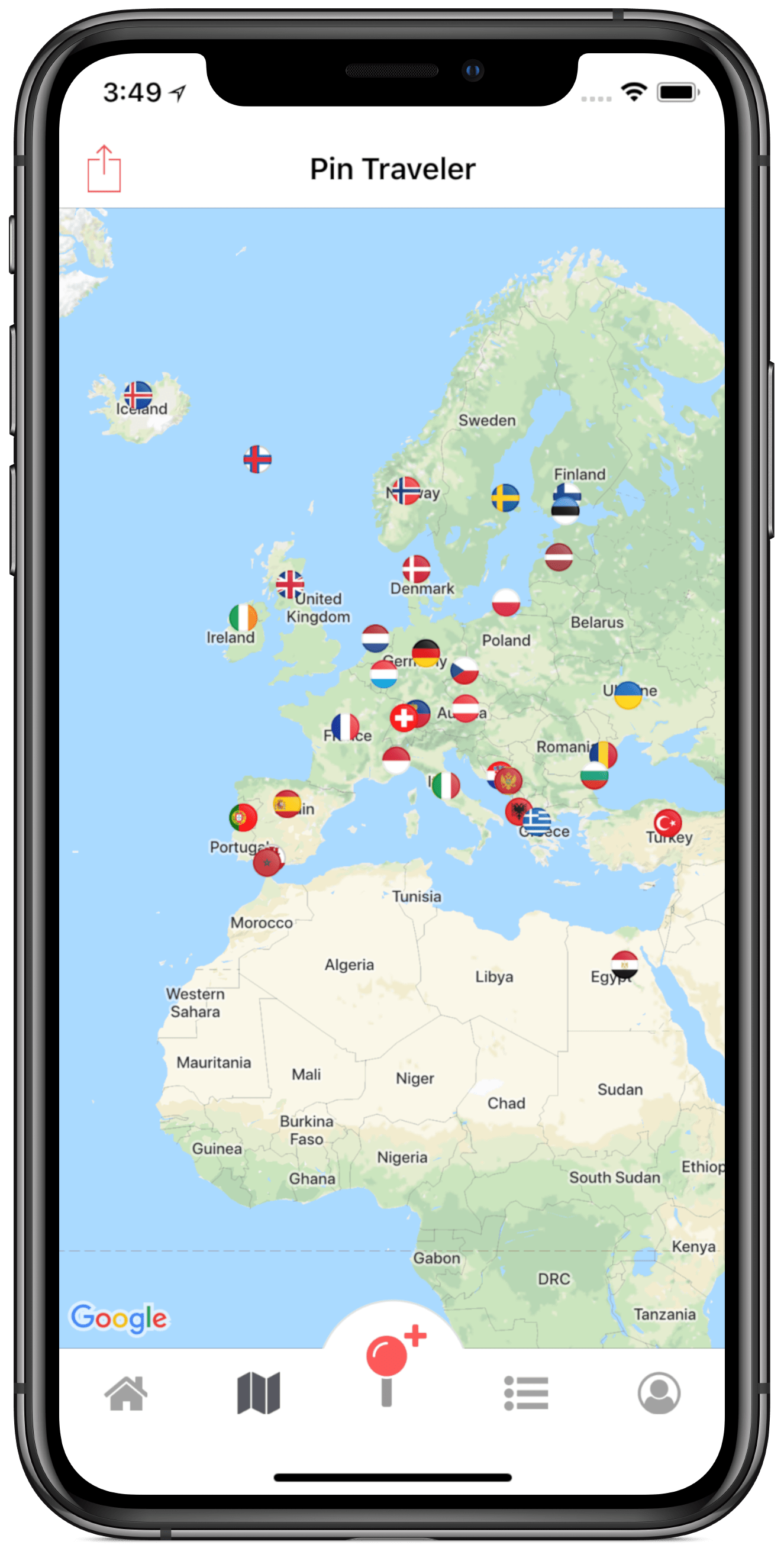
Essentials for Travel Tracking
Search from millions of locations available and pin your travels on your very own digital push pin travel map!
Easily export your travel map with pins and share on social media or give access to others to check out your map.
Log your trips, archive your photos, save your favorite places from your trips. Never forget your adventures!
Download Pin Traveler App
The must-have travel tracker app! Pin your travels, create your bucket list, save your favorite locations, and much more.
Join Pin Traveler
Get the app and sign up to Pin Traveler in a single click! Creating your own online push pin map is as easy as 123.
Track Your Travels
With text based searching or pin dropping, quickly create your own world travel map to pin where you've been.
View Your World Map
Take a minute to see where you've been on the world map. You can also view your destinations as a list and customize them to make your map more personal.
Share With Friends
Share your world travel map with the press of a button! You can let friends and family see your travel map with pins on their own devices. Disable sharing with ease at any time and keep your map private.
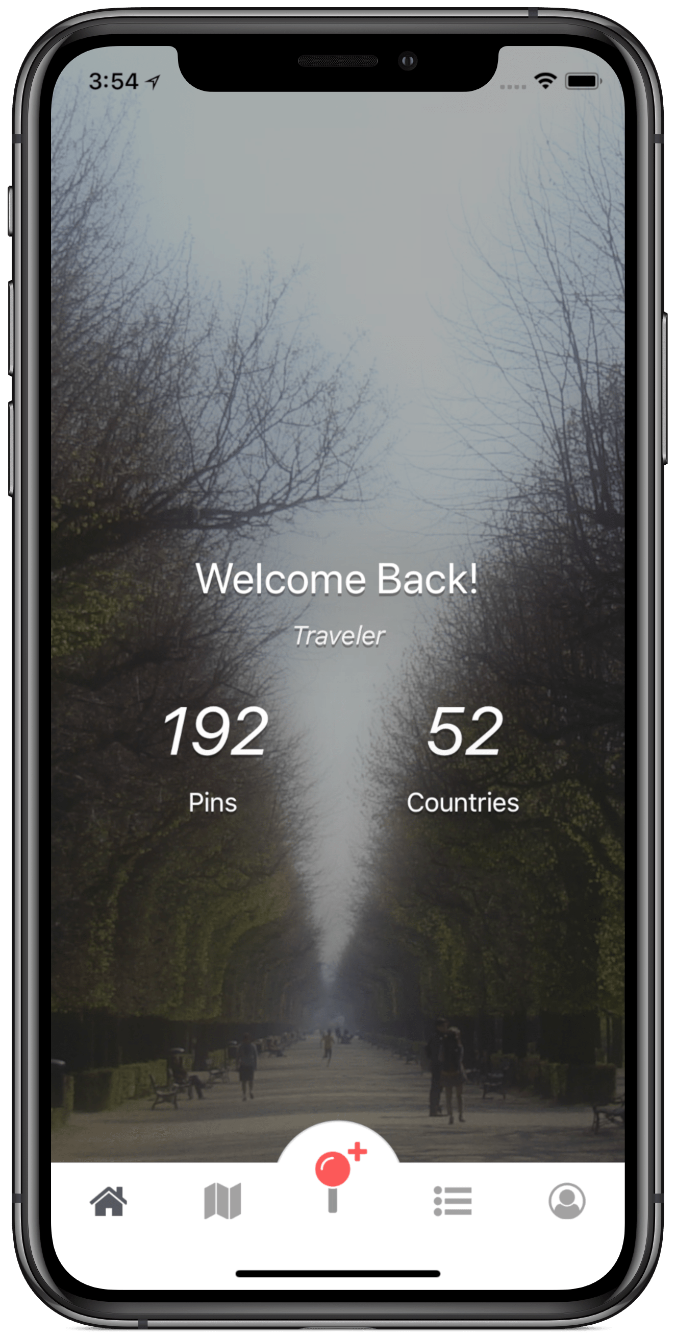
Personalize Your World Map
Bucket list.
Create your online travel bucket list with ease by adding pins to your wishlist.
Customize your travel map with pins, using various pin colors and map styles!
With personalized travel statistics explore how much of the world you have discovered.
App Screenshots
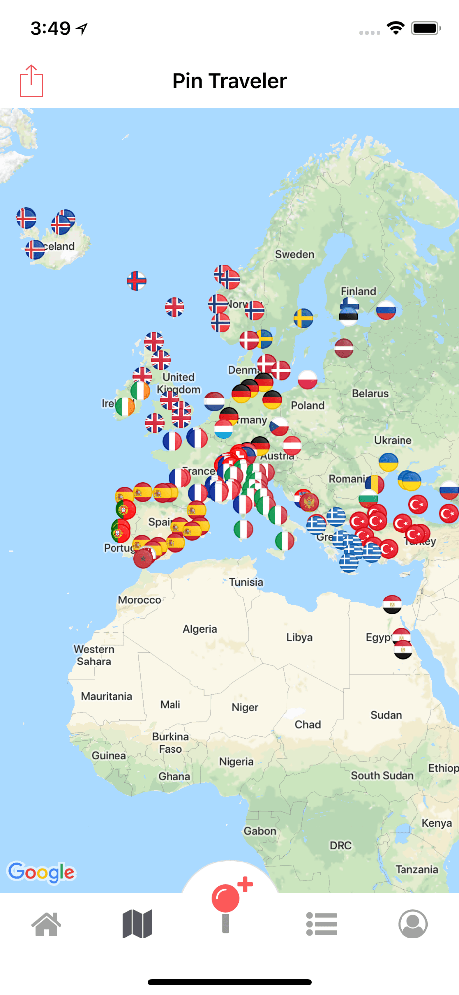
Screenshots from: Pin Traveler App Version 2.7.5 (iOS)
Get the must-have travel tracker app
Pin Traveler is now available for Android!
User Testimonials & Reviews
See why our users love tracking their travels online with Pin Traveler
Amazing app! ⭐⭐⭐⭐⭐
“ I am an Airline Pilot … and I've been searching for perfect app that helps me keep track of all the cities I've travelled to. Trust me. This is it. The $2.49 premium monthly subscription is well worth it. And also, the $0.99 map designs are really beautiful. ”
Awesome Travel Diary App ⭐⭐⭐⭐⭐
“ After years of looking for a travel diary, … I found what I'm looking for. This has everything I have searched for, … in this one app. ”
Great app ⭐⭐⭐⭐⭐
“ I love this map. I am using it to pin my travels over the past 40 years. It will take a bit of time but I am enjoying the memories. ”
Nice Nostalgic App! ⭐⭐⭐⭐⭐
“ Pin Traveller helps me keep track of my visits with an simple and intuitive interface. Reminds me of my grandfather's old travel diaries. :) ”
I use this to mark my products ⭐⭐⭐⭐
“ I use this to see where our products have been shipped too from purchases. I really like seeing the overview of the map and where our barrels and poles have been sold. … This gives us a great overview of where our products are being purchased. ”
Keep In Touch
Check out our new Blog !
Sign up for Our Mailing List
COPYRIGHT © 2018-2023. Pin Traveler LLC
Visited: Travel Map With Lists 4+
Trip planner with bucket list, arriving in high heels, designed for ipad.
- 4.6 • 10.2K Ratings
- Offers In-App Purchases
Screenshots
Description.
Beat your own travel stats. Get inspired to visit exotic new destinations. Track your experiences around the world as you tick off your bucket list. MAP YOUR TRAVELS -Design your personal travel map by displaying countries, states / provinces / regions and cities of where you have been or want to visit. GET INSPIRED -Visualize your future travels by swiping through beautiful photos and adding them to your wishlist. TRAVEL ITINERARY - Wondering where to travel next? We got you covered. Select different destinations and places based on travel lists, experiences and inspirational photos. We'll show you which countries have the highest numbers of places you wish to visit. So you can go down the list and optimize your travel plans. - Picking your next travel destination just got a lot easier with the Visited App! TRAVEL BUCKET LIST -Keep up with your travel life goals by selecting all the countries of the world that you want to visit. -Add travel journal notes by country of your travel dates, points of interest or personal memories. KEEP TRACK OF YOUR TRAVEL JOURNEY -Share your personalized stats with others! You can share your travel ranking, percentage of the world seen and countries you’ve visited. -See your top 5 most frequently visited countries. -Create regional maps for over 20 countries, including United States, Canada, Australia, Germany, UK, Russia, France and others. TRAVEL EXPERIENCES -Want to see how many of the worlds’ capital cities you have been to? Or how about how many art museums you’ve visited? Using the list feature, check off places you have been to or want to visit by category. Lists include: African Safaris, Capitals of the World, Wonders of the World, Pyramids, Culinary Experiences, Ancient Sites, Churches, Greek & Roman Ruins, Cruise Ports, Beer Destinations, Palaces, US national parks, Ski Slops, World's Top Beaches, Shopping Destinations, LGBTQ+ Destinations, Popular Hiking Trails, Lakes, Bridges, Snorkelling/Diving Locations, Chocolate Destinations, Castles, Wine Regions, Kids Attractions, Temples, Mountain Ranges, Rock Climbing Locations, Monasteries, Opera Houses, Funicular Railways, Waterfalls, Volcanos, Mosques, US National Monuments, Hot Springs, Tunnels, US Memorial, Dance Shows, Deserts, Famous Prisons, Canal Cruises, Formula One Circuits, Top Surf Spots, Underground Cities, Whale Watching Spots, Synagogues, Caves, US National Historic Site, Tennis Destinations, Film Festivals, US National Battlefields and Scotch Distillery Regions. -Track your experiences by country such as where you’ve gone golfing, snorkelling/diving, skiing, wine tours and others. FULLY CUSTOMIZABLE -Select different colors or design your own based on your travel type -Pick fully accessible, high contrast colors for your map. -Dark mode is supported to make the app easier to use while taking a red eye flight -Adjust the sovereignty for disputed territories SEE HOW YOU COMPARE TO OTHER TRAVELERS: - Compare your travel stats with other global travellers or friends - See the top 10 most popular countries to visit from your home city - Share your travel map, stats and bucket list with your family and friends Have you ever had a problem where you can’t actually remember all the countries you’ve been to? That’s why we created Visited – a simple and fun travel tracker. With Visited, you will be able to not only keep a log of all the countries, regions, and cities you’ve been to, but you’ll also be able to see your accomplishments beautifully rendered on a world map that you can share proudly. A digital scratch map if you will! You can also use Visited to plan your upcoming adventures by being inspired by breathtaking travel photos and building up your bucket list.
Version 4.2.4
- Adding Video - Adding New Lists
Ratings and Reviews
10.2K Ratings
I WANTED to like it!
I wanted to like it, but too frequently, I click on the App and Its prompting me to re-enter everything: where I've travelled, where I live and desired destinations ... ALL OVER AGAIN!!! Soooooo frustrating! And quite frankly, it doesn't DO ALL that much!!! You choose the countries, the states, if you live in the US, some color selections and that's it!!!! That's all you have to input!!! So, Why can't it retain that little information???? And in return it displays where you've been displayed on a world map, the percentage of the world you've seen and where you rank amongst other users. So you know want to know where this APP Ranks??? A (2)!!! Visiting new destinations is supposed to be exciting! How is that reflected in this App? What is the point if you're more frustrated using this app than going through TSA!
Developer Response ,
We are sorry for the frustration! We have launched a new version of the app that not only fixes the issues mentioned but also comes with new features such as cities, regions, and travel inspirations (to name a few!). Please let us know if you have any other feedback by emailing us at [email protected]!
Good idea but…
This is a good app and I even paid to remove ads and to unlock all the features. HOWEVER, it needs to give more control to the user. They collect so much of your personal information. It’s like either use it and let us collect these information, or leave it. Also, I was forced to sign up to their newsletter. It said I can withdraw from their newsletter at anytime but there is no option for that in the map. I paid for the premium features but you know what? Don’t. None of the premium features were worth it. Let me start off by cities. You can type and choose the cities that you’ve been to and cities that you want to visit. But that is it. You can’t even see a list of those cities that you want to visit, let alone a map of it. Looks like they made it easy for them to collect our information. Inspiration doesn’t have anything. It said it would show travel photos. The only photo it shows is the thumbnail when you select from want/been. If you do download this app, please do go to privacy section and read the “What personal information do we collect?” Section. So far, what a waste of money it has been. If it gets improved, I will update my review.
Thank you for your feedback. We are apologizing for any issues you may have had with the app. Please email us at [email protected] so we can see how we can improve your experience with the app.
Essential travel app
Every traveler should have this app to track countries visited. I’ve been using it for a few years now and seen it progress in features and usability. I love the latest enhancements, particularly new countries with states. But there are additional enhancements that I’d like the developers to consider. Here are my top 3: 1. Small countries are really hard to see on the map right now. Can you make it easier? For example, Liechtenstein gets lost between all of the states. And Pitcairn is nearly impossible, at least for me, to find without using the search feature. 2. Dates of visit would be nice 3. Ability to export the list to a spreadsheet. Bugs? There are a couple but nothing really significant, e.g. South Georgia and South Sandwich are not in Europe. There may have been a conversion bug as my list of countries went from 60 to 58. I reviewed and updated it and it’s now back to 60. Overall, a great app, worthy of of 5 stars!
Thank you so much for helping us improve our app. We have added your suggestions to our "enhance" list. We wish there were more feedbacks like yours. Your help is truly appreciated. Happy travels!
App Privacy
The developer, Arriving In High Heels , indicated that the app’s privacy practices may include handling of data as described below. For more information, see the developer’s privacy policy .
Data Linked to You
The following data may be collected and linked to your identity:
- Contact Info
- Identifiers
Data Not Linked to You
The following data may be collected but it is not linked to your identity:
- Diagnostics
Privacy practices may vary, for example, based on the features you use or your age. Learn More
Information
English, Catalan, Croatian, Czech, Danish, Dutch, Finnish, French, German, Greek, Hungarian, Indonesian, Italian, Japanese, Korean, Malay, Norwegian Bokmål, Polish, Portuguese, Romanian, Russian, Serbian, Simplified Chinese, Slovak, Spanish, Swedish, Thai, Traditional Chinese, Turkish, Ukrainian, Vietnamese
- Visited Pro $12.99
- Unlock Cities $7.99
- Unlock Regions $3.99
- Remove Ads $3.99
- More Inspirations $3.99
- Unlock Itineraries $7.99
- Developer Website
- App Support
- Privacy Policy

Get all of your passes, tickets, cards, and more in one place.
More by this developer.
Pay Off Debt: Debt Calculator
The Fertility App – IVF & IUI
XWalk: Nordic Walking Tracker
You Might Also Like
Pin Traveler: Travel Tracker
Places Been - Travel Tracker
Skratch - Where I've been
Mark O'Travel: Where I've Been
Polarsteps - Travel Tracker
Trace your travel itinerary on an interactive map
For past, present and future trips. Attach photos, videos and articles to your map. Share it with a simple link.
A modern travel blog centered on a map
Easy for you to manage. Easy for your family and friends to follow.
Your own website
Create a free account to store all your maps.
Share the link with anyone you want. They don't need an account to follow you.
You can protect your blog with a password to make it private.
A map on your homepage
The best way for visitors to visualize your trip is the itinerary, show them:
- where you are
- where you've been
- where you're going
- the transport modes you used
Content comes next
Once you added your spots, you can attach content to them:
Personalized maps
Use the map editor to add your points, trace your lines or import GPS files.
Choose the map style, the marker icons and the line colors (defined by your transport modes).
No technical knowledge required.
Works on any device
Most travelers update their blogs on their smartphone or tablet.
You don't need to install any app. Just open the link to your blog or administration.
Automatic / real-time updates
You can synchronize compatible smartphone tracking apps with your map to update it automatically.
For remote adventures across oceans or deserts, you can synchronize satellite GPS trackers .
Embed your map
If you already have a website, you can embed your map on any page.
Compatible with WordPress, Wix, Squarespace, etc.
Print a photo book
Generate a travel book in one click from the content you already have to keep a tangible souvenir.
You can also download the PDF version to keep a digital copy.
Free for basic features, pay for extra
I don't display ads nor sell your data. So advanced features require a Premium account to keep TravelMap viable.
Stop paying when you don't travel. Keep all your content.
Ideal for long distance trips
Used by 150 000 travelers . Find inspiration from existing itineraries.
Built by Clément Mas. Solo-founder who cycled around Australia and rowed across the Atlantic ocean . Also a web developer.
Striving for a simple, clean and clear interface
Create your travel blog in 2 minutes.
Use this tool to create beautiful interactive maps of the places you have been in the world or within any country. Create smooth animations or static images. Embed them into any website or blog. Share on Facebook, Twitter, TikTok, Pinterest, or any other social network. Awe your friends and followers with a cool-looking animation video or as a true child of Internet with an animated GIF.
Quick templates
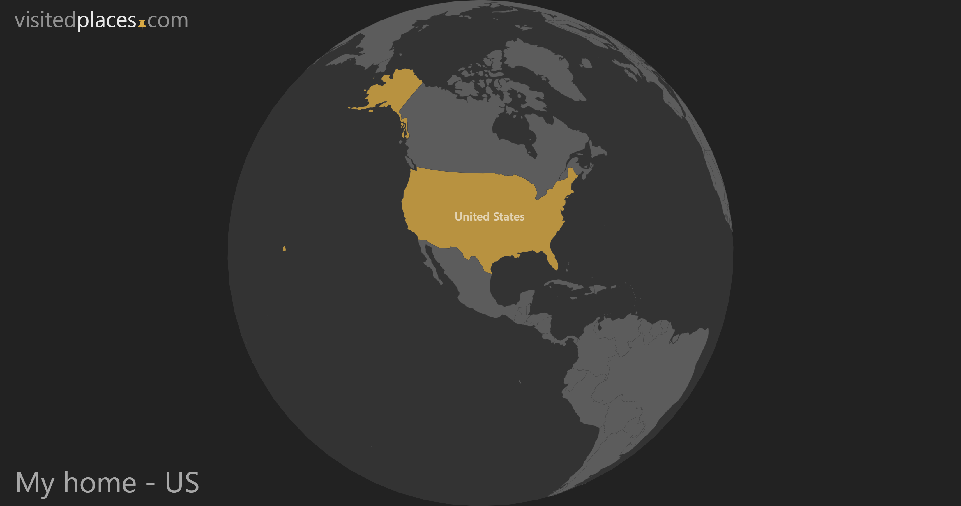
- Map & Counter
- Most Visited
Countries Visited Map & Counter
Explore the world on our interactive map! Mark, showcase and count the countries you have visited – your travel story, your way.
Number of Countries visited
of the World traveled

Visualize and count the countries you have visited
Use the world map as a digital scratch card and mark all the countries you have already visited with a few simple mouse clicks. Whether it was a brief city excursion, an extensive vacation, or a phase of living abroad, you can capture and visualize those experiences on this map. If you're unable to locate the countries you have visited on the map, the list beneath it is your guide.
Select the Countries
The following form lists all countries globally, including numerous dependent territories, organized by continent. Simply select the country by checking the box, and watch as it automatically fills with color on the map. This action will also increase the country counter by one. Additionally, you can directly observe the percentage of the world you have already traveled.
Africa (55)
Europe (50), north america (35), australia & oceania (31), south america (15), antarctica (1).
Have you gone through the list and marked all your visited places? Which countries are still missing? Let a random country name generator inspire you for your next destination.
Share your Travel History
Embark on a visual journey with our interactive world map that lets you explore and highlight the countries you have visited. Whether you're a seasoned traveler or just starting your adventures, our scratch map feature allows you to mark the countries you've been to, creating a personalized travel history that showcases your global experiences. Easily navigate the map, select countries by name, and watch as each destination comes to life with vibrant colors. The user-friendly interface lets you document your travel milestones effortlessly. Want to share your wanderlust with friends? Our platform makes it simple to share your customized map, allowing you to relive your adventures and inspire others to explore the world. So, start pinning, scratching, and sharing – because every journey deserves to be celebrated and remembered on your own personalized map of the world.

RJ Travel LLC » Travel Agency & Tour Operator
Re-writing the concept of tourism and taking you on adventure tours to Iraq, Morocco, Afghanistan, Yemen, Persia, Lebanon, Saudi, Libya, Uzbekistan.
- Adventure tours
Interactive Country Mapper – Map Visited Countries

Table of Contents
Create your free map of countries visited. Free country mapper and interactive visited countries mapper of all the 193 countries recognized by the United Nations .
This is your easy my country counter, and interactive map of places visited. Keep track of how many countries and places visited and plan your next trip with our interactive map with visited countries.
Whether you’re a seasoned traveler or just starting to explore the world, our map maker is a convenient and fun way to document your travels.
As of 2023, there are 193 member states officially recognized by the United Nations, each offering its distinct charm and character.
Common questions:
- How many countries I have visited?
- How many countries have I visited?
- Countries I’ve visited?
- How many countries have you been to?
Country Mapper UN193
Select the united nations member states that you visited.
Select a continent from the buttons below. Scroll down to choose your visited countries. Scroll back up to see your updated map.
- Azerbaijan 🇦🇿
- Bosnia & Herzegovina 🇧🇦
- Bulgaria 🇧🇬
- Czech Republic 🇨🇿
- Liechtenstein 🇱🇮
- Lithuania 🇱🇹
- Luxembourg 🇱🇺
- Macedonia 🇲🇰
- Montenegro 🇲🇪
- Netherlands 🇳🇱
- Portugal 🇵🇹
- San Marino 🇸🇲
- Slovakia 🇸🇰
- Slovenia 🇸🇮
- Switzerland 🇨🇭
- United Kingdom 🇬🇧
- Vatican City 🇻🇦
- Antarctica 🇦🇶 (will not be counted as country)
- Australia 🇦🇺
- Kiribati 🇰🇮
- Marshall Islands 🇲🇭
- Micronesia 🇫🇲
- New Zealand 🇳🇿
- Papua New Guinea 🇵🇬
- Pitcairn Islands 🇵🇳
- Solomon Islands 🇸🇧
- Botswana 🇧🇼
- Burkina Faso 🇧🇫
- Côte d’Ivore 🇨🇮
- Cameroon 🇨🇲
- Cape Verde 🇨🇻
- Central African Republic 🇨🇫
- Congo Brazzaville 🇨🇬
- Congo Kinshasa 🇨🇩
- Djibouti 🇩🇯
- Equatorial Guinea 🇬🇶
- Ethiopia 🇪🇹
- Guinea-Bissau 🇬🇼
- Madagascar 🇲🇬
- Mauritania 🇲🇷
- Mauritius 🇲🇺
- Mozambique 🇲🇿
- S Tomé & Principe 🇸🇹
- Seychelles 🇸🇨
- Sierra Leone 🇸🇱
- South Africa 🇿🇦
- South Sudan 🇸🇸
- Swaziland 🇸🇿
- Tanzania 🇹🇿
- Zimbabwe 🇿🇼
- Afghanistan 🇦🇫
- Bangladesh 🇧🇩
- Cambodia 🇰🇭
- East Timor 🇹🇱
- Indonesia 🇮🇩
- Israel 🇮🇱 & Palestinian Territories 🇵🇸
- Kazakhstan 🇰🇿
- Kyrgyzstan 🇰🇬
- Malaysia 🇲🇾
- Maldives 🇲🇻
- Mongolia 🇲🇳
- North Korea 🇰🇵
- Pakistan 🇵🇰
- Palestinian Authority 🇵🇸
- Philippines 🇵🇭
- Saudi Arabia 🇸🇦
- Singapore 🇸🇬
- South Korea 🇰🇷
- Sri Lanka 🇱🇰
- Tajikistan 🇹🇯
- Thailand 🇹🇭
- Turkmenistan 🇹🇲
- United Arab Emirates 🇦🇪
- Uzbekistan 🇺🇿
- Antigua & Barbuda 🇦🇬
- Argentina 🇦🇷
- Barbados 🇧🇧
- Colombia 🇨🇴
- Costa Rica 🇨🇷
- Dominica 🇩🇲
- Dominican Republic 🇩🇴
- El Salvador 🇸🇻
- Greenland 🇬🇱
- Guatemala 🇬🇹
- Honduras 🇭🇳
- Nicaragua 🇳🇮
- Paraguay 🇵🇾
- St Kitts & Nevis 🇰🇳
- St Lucia 🇱🇨
- St Vincent & the Grenadines 🇻🇨
- Suriname 🇸🇷
- Trinidad & Tobago 🇹🇹
- United States 🇺🇸
- Venezuela 🇻🇪
🌈 Country map color picker
Copy & Paste this code and use it on your website
Copy the code and add the map to your travel blog to share experiences with friends and followers.
How Did the CEO of RJ Travel LLC Explore 145+ UN Member States?
João Leitão, the founder of RJ Travel LLC – Travel Agency & Tour Operator, has been to a total of 128 out of of 193 UN or 145 of 266 UN+. Check his page about his list of visited countries .
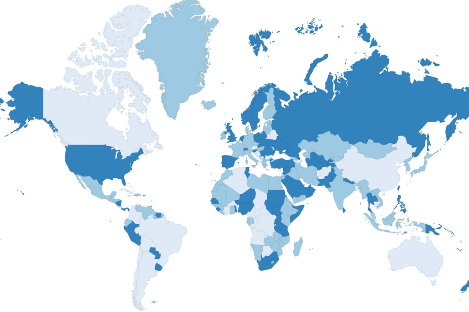
How Many Countries in the World Map » 2023 UN Official Full List
Also interesting for you.
20 Least Traveled Countries in the World for the Adventure-Seeker
25 Breathtaking Volcanoes That Are Active and Easy to Visit
52 Unforgettable Greatest Adventures » Epic Bucket List
Least Traveled Continents in the World
Top 10 Most Visited Countries in the World
How to build a map of countries visited.
A visited places map is an interesting and visually captivating way to showcase one’s travel adventures, providing a colorful and interactive representation of the diverse cultures, landscapes, and memories accumulated across the globe.
Instructions
- Select the continents you’ve visited from the options provided.
- Complete the country visit checklist;
- Select the desired country color;
- Follow your current map of visited countries above the list;
- To use the country counting map on your website, COPY the automatically generated code and PASTE it on your blog’s HTML text editor;
- You can also copy the updated map as an image and share it on social media or with friends.
- Don’t forget to share this page with your friends so they can create their own maps too!
This map maker uses the official member states of the United Nations list to know how many countries in the World .
Looking for a way to keep track of your travels with a country checklist with off the beaten path destinations and the least traveled countries in the world ? Look no further than our free map generator!
With just a few clicks, you can select the countries you have visited and create a personalized map that you can easily share with friends and family.
The free map generator even includes a country counter that shows you the total number of countries and continents you have explored, as well as the percentage of countries you have visited. Whether you are an experienced traveler or just getting started, this tool is a great way to keep track of your adventures and share them with others.
And the best part? It’s completely free to use! So start mapping out your travels to some of the world’s most unique and least explored destinations today.
FAQ – Visited Countries
How many countries are there.
There are a total of 193 recognized countries in the world today, as recognized by the United Nations (UN). This includes member countries, as well as observers, states, and other entities.
Some sources may also include Taiwan and Palestine, bringing the total number of recognized countries to 195. A country is a geographical region that is politically and administratively independent. It is governed by its own government or administration and has its own laws, policies, and systems.
Each country has unique culture, history, language, and traditions. Some countries are small in size, while others are large and sprawling. Some countries are on different continents and separated by vast oceans, while others are located close together and share borders. Each country has its own political system, economic structure, and social norms.
Countries can be classified in many ways, including by their development level, size, and location. Some countries are considered developed, with advanced economies, high levels of education, and well-established infrastructure.
Other countries are classified as developing, with growing economies but still have a ways to go before reaching the level of developed countries.
The concept of a country has evolved over time, with the concept of statehood and sovereignty playing a central role. In ancient times, the concept of a country may have been limited to a city-state or a region controlled by a single ruler.
Today, the concept of a country is much more expansive, with countries having the ability to govern themselves and make their own decisions on a wide range of issues. In conclusion, a country is an independent region governed by its own administration or government. There are a total of 193 recognized countries in the world, each with its own unique culture, history, and traditions. Countries can be classified in many ways, including by their level of development, size, and location.
What are the advantages of traveling to other countries?
Traveling to other countries can be a rewarding and enriching experience. There are numerous advantages to traveling abroad, including:
Exposure to new cultures : Traveling to other countries allows you to immerse yourself in a new culture and learn about the customs, traditions, and way of life of people from different parts of the world. This can broaden your perspective and help you better understand and appreciate other cultures.
Language learning : Traveling to a country where the primary language is different from your own can be an excellent opportunity to learn a new language or improve your language skills.
Personal growth : Traveling to new and unfamiliar places can push you out of your comfort zone and help you grow as a person. It can also increase your independence and self-confidence.
Career opportunities : Traveling to other countries can enhance your resume and make you more attractive to potential employers, especially if you have language skills or international experience.
Health benefits : Traveling can be good for your physical and mental health. Being in a new environment and experiencing new things can reduce stress and improve overall well-being.
Fun and relaxation : Traveling can be a fun and enjoyable way to relax and take a break from your everyday routine. It can also provide an opportunity to try new activities and hobbies.
Making new friends : Traveling to other countries can introduce you to new people and help you make friends from different parts of the world.
Overall, traveling to other countries can provide many benefits and create lasting memories. It can broaden your horizons, enhance your personal and professional development, and allow you to have fun and relax.
Why should anyone visit every country in the world?
Every nation is exceptional. Some have resemblances and share common cultural characteristics, but even geographic areas can influence how a culture forms.
Have you ever dreamt of visiting every country in the world? It might seem like a daunting task, but there are countless reasons why you should consider it.
First and foremost, traveling to every country in the world would allow you to experience an incredible range of cultures and ways of life.
Every country has something unique and special to offer, from the vibrant cities of Europe to the stunning beaches of Southeast Asia. By visiting every country, you would have the opportunity to learn about different cultures, try new foods, and meet people from all walks of life.
In addition, traveling to every country in the world would allow you to learn new languages and improve your communication skills. Whether you’re picking up a few phrases in French or becoming proficient in Mandarin, learning a new language can be a rewarding and enriching experience.
Furthermore, visiting every country worldwide would be an incredible personal achievement. It would take dedication, planning, and a willingness to step outside your comfort zone, but the sense of accomplishment you would feel upon completing such a feat would be unparalleled.
So why should anyone visit every country in the world? Because it would be an incredible adventure that would allow you to experience new cultures, learn new languages, and achieve a personal goal. Don’t let the fear of the unknown hold you back – start planning your journey to every country today!
Ready for an adventure? Let’s make it happen!
Reach out to our passionate team, and we’ll respond within 48 hours to shape your travel ideas into a unique journey designed just for you.
888-821-0151

$10 off framed maps over $100 with code 10FORTRAVEL
Travel maps to last a lifetime
Personalize your map and then pin your travels! These maps are the perfect gift for anyone who loves or is inspired by travel.
Spread the joy of travel
There is so much delight and anticipation in filling a map with travel memories. Personalized maps make meaningful, long-lasting gifts!
Give a gift that keeps your traveler inspired!
A push pin map lets them track their travels, recall past adventures and plan new ones!
Testimonials
Beautiful my husband and i are so excited to track our adventures with this lovely map. fast shipping and in perfect condition., breathtaking in person my husband and i first saw this in a home of an airbnb host and knew we had to have it it's absolutely perfect and a great conversation piece. each pin marks a precious memory. perfect for travelers, adventurers and perpetual wanderers., i bought this as an anniversary gift. it came beautifully framed with a nice, engraved personalization plate. even nicer than i had hoped. my husband loved it and it will make a pretty addition to our wall — not to mention a cool way to capture travels and travel plans., bestsellers.

Map Your Travels Push Pin World Travel Map Framed
from $ 169.00

Personalized World Traveler Push Pin Map

Urban Slate World Travel Map

Contemporary World Travel Map
from $ 99.00

Give a gift with a personalized touch!
We individually print each plaque, so your message will be uniquely yours! Whether the map is a gift or for your own family, make the personalization as special as the recipient.

Customers trust us
We have been selling our heirloom-quality maps for over 20 years to thousands of happy customers! Our mission is to provide quality craftsmanship, outstanding customer service, and exceptional maps made in the USA!
The National Parks Collection
Celebrate the national parks with coasters, prints, maps and posters
Modern Traveler Maps
Featuring modern graphic design — these maps are the latest in our Traveler Map Series
- Bucket List Maps
From the sports lover to the outdoor enthusiast — track all of your adventures with a Bucket List Map!
How a Map is Made
Our maps have been seen on:

Regular price $ 179.00
Unit price / per
only -228 left in stock
Email Sign Up
Sign up for special promotions available only to our email subscribers!
Celebrating 20 Years!
Thank you for supporting our family-owned small business. We couldn't have done it without you!
- Travel Maps
- Scratch Maps
- Travel Decor
- Global Gifts for Good
Shopping Cart
Your cart is currently empty..
MapFling: easily share free maps with your own custom markers!
Mark custom points on map with your own annotation or description, share the map with others by email, instant messaging, blog, websites, party invitations, wedding, events, evites, corporate hospitality and hotel and restaurant travel: welcome business customers and interview candidates to office visits, meeting maps for appointments, meeting your friend, online date, boyfriend, or girlfriend, real estate, house rentals, apartments for rent, properties for sale, collaborate on maps for travel plans, scavenger hunts, real estate.
Perm, Russia General info on the city of Perm A short intro... Perm is the most Eastern city of Europe, and therefore its province is often referred to as Eurasia. Having a population of 1 million, Perm' is one of the largest cities in Russia and the second largest in the Urals. The city was formerly called Molotov, after the minister of foreign affairs during Joseph Stalin's ruling. Perm stretches 65 km along the impressive Kama River - Europe's 4th largest river by length. The Perm province, "Permskiy Krai", or "Prikamye", is around two-third the size of the United Kingdom and covers a great area in the very heart of the Ural Mountains. Perm is internationally known as the name for the geological period (290 - 245 million years ago) in which the Ural Mountain Range was formed. In contrary to the Urals, Perm itself is rather young. Although the first settlement of Perm dates back to 16th century, officially it got its city status in 1723. Citizens still loudly celebrate Perm's birthday on 12th of June, with street parades, concerts and fireworks throughout the whole city! In spite of being a relatively young city, Perm played an important role in the history of Russia. Not the least part of this role was played by Ermak, who was from the Perm Province. Ermak, by order of the Stroganov family, gathered an army here and led it through the Urals, later to succesfully conquer Siberia for Russia. Afterwards, when a road was needed to connect Siberia with the west, construction was started in Perm, which was at that time the capital of the Ural region. The new road, together with the construction of the Trans Siberian Railroad, allowed development of the places east of the Urals - current big cities such as Ekaterinburg, Omsk and Novosibirsk, were merely peasant or miners' towns by that time. Nowadays, Perm basically owes its existence to two factors. Firstly the large amounts of natural resources (minerals, oil and timber) that are present in the region, and secondly (but not less important): its location. The mighty Kama River, the Great Trans Siberian Railroad and main motorways from Moscow/Kazan to Siberia all cross in Perm, making Perm a main Russian transportation hub. The city is the doorway from Europe to Asia and to Siberia in particular. During Soviet times, Perm was a proper fortress because of the huge military industry in its region. All artillery and rocket vehicles, as well as (intercontinental) ballistic rocket launching systems, engines for MiG jetfighters and canons of all ranges were (and in less proportions still are) produced in Perm. The Soviets did an excellent job in hiding Perm and keeping it secret. Most people from outside the Urals simply did not know of the existence of the - at that time - 1 million citizens of Perm. Until the end of the cold war, Perm did not appear on certain Soviet-made maps, nor did the roads towards it. Nowadays, Perm is obviously accessible to all. Actually, it currently is one of Russia's fastest growing cities because of its economical prosperity. Click here for specific information for visitors: Perm sightseeing / excursions and Perm hotels . Perm - 101% Russian, yet multicultural For Russian standards, Perm is one of the most multicultural places in the whole country; it is a home of many ethnic groups who have lived together in Perm ever since its existence. While taking a walk through Perms huge central bazaar one can easily distinguish Russians at the many typical small kiosks, Georgians and Armenians selling their original spicy kebabs and shoarmas straight from the barbecue and Tatars operating from most of the simple but colorful jewelry stands. Furthermore, Russian orthodox churches, a mosque, a synagogue and several Catholic churches (some dating from the 17th century) all exist next to each other in Perm. The multicultural character of Perm also shows in its dining possibilities; one does never have to go far to experience the Russian, Uzbek, Georgian or Caucasian cuisine. In spite of its multicultural character, Perm is Russian till the bone. Wide avenues, big squares and parks, many statues, dominant Soviet architecture, countless little kiosks, huge theatres and trolley busses everywhere - all make Perm as Russian as Russian can be. Being some 1400 kilometers away from the big influential cities of Moscow and St. Petersburg, Perm is a relaxed place, where people have kept the typical Russian way of life and traditions. The Perm opera and ballet theatre After St. Petersburg and Moscow, Perm is Russia's leading city for opera and ballet theatre. Not only has the city got a wide range of stages and theatres, its educational bodies like the Russian Academy of Theatre Art and Institute for Culture and Art as well as its many international relations in theatre performances and education still give Perm the name of theatre city. One of the most famous stages is the Chaikovsky Opera and Ballet Theatre Perm. Among its repertoire are internationally known performances (for example Romeo and Juliet, Cleopatra, Aida, Cinderella, Le Nozze di Figaro) as well as Russian ones: most works of Chaikovsky have been staged here. Since 1948 the Perm Opera and Ballet Theatre has been on tours throughout the whole world, performing in countries such as UK, Japan, New Zealand, Australia, Hungary, the Netherlands, Bulgaria, Germany and China. During its history, the theatre has received numerous (inter)national prizes. Another leading stage is the Perm Academic Drama Theatre, founded in 1927. Like the Perm Opera and Ballet Theatre, the Acamedic Drama Theatre has staged the worlds most prestigious Drama plays (for instance Ostrovsky, Shakespeare, Gorky and Tolstoy) and has it won many prizes for its work. Museums The Perm Art Gallery boasts a large collection of arts. Apart from numerous paintings of Flemish, French and Italian masters, it also has modern art collections on exhibition. The museum's collection is among the very largest ones in Russia. The museum is located in a former cathedral, now a landmark of Perm in the centre of the city. For those who are interested in the history and the culture of the Urals, the Regional Museum of Local Studies and History (founded in 1890) is definitely worth to visit. The museum boasts a wide variety of armory, coinage, pottery, handicrafts, archeology and minerals. It also tells about the Permian period, the geological era in which the Urals were formed. The partly open-air artillery museum at the northern end of the city centre displays all generations of rocket and artillery (vehicles), as constructed in Perm, as well as a wide range of information of the history of the industry. Actually, the city is known for its large war industry ever since late 1800s. All cannons and artillery of former Soviet Union as well as engines for Tupolev and MiG aircrafts were (and in less amounts still are) manufactured in Perm. The museum offers detailed information on its wide range of warfare. The outside part of the museum can be entered free of charge at any time. This museum is a part of our city excursion . Khokhlovka (Open-air museum of and Wooden Architecture and Ethnography) is in fact a collection of original structures as they existed in the 17th century. Inside the buildings, all kinds of tools, handicrafts and clothes of that time are exposed. The guide will take you around the museum, telling about the hard life 300 years ago. You will be amazed by the beauty of the site; Khokhlovka is located on a green hill and offers great views over the Kama river and nearby villages. Architecture As for architecture, most profound buildings are situated in the city centre. The heart of the city is very unlike what one can expect from a city of over one million inhabitants. It completely lacks the usual modern glass buildings and tall skyscrapers that make up for most big cities centres. In fact, Perms centre is mostly made up by colorful, classic 3-storied mansions of Soviet architecture, making the centre breath a rather relaxed and pleasant atmosphere. Among the most prominent buildings in the city are the centrally located "Young people's theatre", the Feodalyevskaya Church and the Dyagiliev Mansion. Furthermore, the Perm I train station is worth a look, as it is proper ancient (17th century). In the provincial towns surrounding Perm, such as Kungur, Solikamsk, Usolye and Osa, architectural highlights are dominated by mansions and factories which were built by the Stroganovs and Demidovs in the 17th century. In similar style, a large number of remarkable churches and cathedrals can be found throughout the Perm Province. Famous people In spite of Perm being a relatively unknown city, the city and its region brought forward many famous people. Ballet impressario Sergei Dyaghilev was born in Perm and spent early years of his life here. He became a sensation in Europe during 2 decades of his "Ballets Russes". Dyaghilev's former mansion in the centre of Perm is now a museum. Chaikovsky, one of the greatest composers ever, was born in a small town just south of Perm. Furthermore, Perm was home of Popov, the inventor of radio, and of Boris Pasternak, who wrote Dr. Zhivago here. The Stroganovs, the Demidovs and Tatishchevs in Perm make up for Russia's famous industrials. Ballet impresario Sergei Diaghilev wrote history when he produced the ballet sensation "The Rites of Spring" in Paris in the early years of the 20th century. Sports For those who are more into sports rather than theatre, Perm has many possibilities. Especially in weekends, the offer is large. Football games of Amkar (promoted to Russias premier league in 2003) and Molot-Prikamiye (see club logo on the right) ice hockey matches take place frequently. Click here for all matches of Perm sports teams. Shopping Shopping in Perm is an experience on its own. Like most other cities in Russia, Perm has not got obvious Western-style shopping streets, although the central Komsomolsky Prospekt is steadily developing into one. New and modern stores are appearing in and around this proper avenue at a fast rate, among which mostly fashion, jewelry and dining places. For daily needs, the huge central bazaar is the most popular place. For any tourist, a visit to this site of countless little stands, shops and kiosks simply cannot be missed. The whole city comes together here, making the bazaar probably the most vivid place in Perm. Fruits, vegetables, clothes, cleaning products, tools, audio, sunglasses, kebabs, carpets, almost ANYthing can be purchased here, and usually for very little money too. The large building in the centre of the bazaar is the place where all kinds of meat and milk products are sold. For those looking for cheap clothing, the Chinese-Vietnamese market is the place to go. Decent but cheap is the main subject among the mainly Chinese trade-people at the market. Furthermore, several smaller markets (rinki) can be found all over the city, mainly at the crossings of major streets. A number of shopping malls serve those who like to have everything in one building. The biggest one is Univermag on the corner of Lenina and Komsomolsky Prospekt. Just across the road are many bakeries, cafés and kebab stands for a short break and a quick snack. Public Transport Perm has an extensive public transport system, operated by busses, taxi busses, trolley busses and trams. They take you to wherever you want to go in the city, even to far outskirts. The standard fare for any means of public transport is 13 rubles, to be paid to the conductor on entrance. Taxi busses start around 6:30 am and stop at 21 pm. All the other transport starts at 5:30 am and goes until 0:30 am. Taxis, naturally, drive 24 hours. If you do not know the city well, it might be difficult for you to find your way through the complicated public transport network. The best thing you can do is to ask the hotel receptionists or your host family which bus or tram number you need. Just remember the name of the stop you departed from, so it will be easy for people to give you directions back, just in case you are not sure which one to take. It is also possible to buy a city transport map at any paper/magazine kiosk, they cost around 2 euro. Events in Perm Events in form of sports and theatre take place nearly every day, one shall not get bored! Most interesting performances of ballet, drama and opera are staged at the Drama Theatre, which is located on Lenina Street, at the central square. The Perm Academic Theatre offers all kinds of famous plays, both Russian and international, and has a full events calendar every day of the month. Matches of Molot Prikamye (ice hockey) take place at the Molot Stadium, which is loacated in the eastern part of Perm. Amkar plays Russian premier league football in stadium "Zvezda", which is in the city centre. Celebrations throughout the city often take place on Russian national holidays: December 31st, New Year January 7th, Orthodox Christmas February 23rd, Day of Defender of Motherland (fireworks) March 8th, Women's Day May 1st, Spring and Labour Day May 9th, Victory Day (military parades in city centre) June 12th, Independence Day and birthday Perm city! (huge fireworks at midnight) November 4th, National Accord Day Furthermore, several occasional as well as annual music, theatre, folklore and anniversary festivals take place in Perm and its region. There is always something to celebrate in Perm! Perm city map A map of Perm city centre, as well as a province map, you'll find on a seperate page. Click here for Perm city map . Perm Weather & Climate Russia is renowned for its long and cold winters. In case of Perm in particular, this is only partly true. Perm has a temperate continental climate: winters are by far not as harsh (average day temperature in January is -15C) when compared to the more eastern parts of the country. Summers are usually very sunny and warm, averagely +25C in July- and August day times. During those months, many citizens can be found sunbathing on the Kama beaches. Current weather: -->
- Random destination
- Bosnia and Herzegovina
- Cabo Verde / Cape Verde
- Cayman Islands
- Christmas Island
- Cook Islands
- Democratic Republic of the Congo
- Equatorial Guinea
- Falkland Islands (Islas Malvinas)
- Guinea-Bissau
- Isle of Man
- Norfolk Island
- Saint Lucia
- Sint Maarten
- São Tomé and Príncipe
- U.S. Virgin Islands
- United Kingdom (UK)
- Wallis and Futuna
- United States of America (USA)
- Central African Republic
- Cocos (Keeling) Islands
- Faroe Islands
- Marshall Islands
- Myanmar (Burma)
- Netherlands
- North Korea
- Papua New Guinea
- Philippines
- Puerto Rico
- Saint Barthélemy
- Saint Martin
- South Africa
- The Bahamas
- Turkmenistan
- Vatican City / Holy See
- Western Sahara
- Afghanistan
- American Samoa
- Antigua and Barbuda
- Burkina Faso
- Czech Republic
- Federated States of Micronesia
- French Guiana
- Macedonia (FYROM)
- New Caledonia
- Northern Mariana Islands
- Pitcairn Islands
- Saint Helena, Ascension and Tristan da Cunha
- Saint Pierre and Miquelon
- Saudi Arabia
- Sierra Leone
- South Korea
- Switzerland
- Trinidad and Tobago
- Turks and Caicos Islands
- British Virgin Islands (BVI)
- Côte d'Ivoire
- Dominican Republic
- El Salvador
- French Polynesia
- Liechtenstein
- New Zealand
- Palestinian Territories
- People's Republic of China
- Republic of the Congo
- Saint Kitts and Nevis
- Saint Vincent and the Grenadines
- Sint Eustatius
- Solomon Islands
- South Sudan
- Timor-Leste / East Timor
- United Arab Emirates (UAE)
- 18 Provider
- 1 Organizations
- 2 Portals / Price Comparison
- 133 Provider
- 3 Portals / Price Comparison
- 558 Airlines
- 42 Organizations
- 173 Cruise Lines
- 3 Organizations
- See all posts in our travel blog
- 114 Destinations / Maps
- 6 Updates / New on travelario
- ...and 1 additional tips!

Favorite Locations
Information information about perm, russia.
- Official Website
- US Department of State
- World Fact Book
Comments Comments about this page ( 0 )
You can add comments for this map below. Are there important locations missing or is some data incorrect/outdated? Do you have suggestions that might be helpful for other travelers? We´d be glad to get your feedback. More information about data privacy, netiquette can be found here .
Additional Russia maps: Chelyabinsk , Grozny (Chechnya) , Irkutsk , Kaliningrad , Kazan , Krasnodar , Krasnoyarsk , Moscow , Murmansk , Nizhny Novgorod , Novosibirsk , Omsk , Rostov-on-Don , Russia , Saint Petersburg , Samara , Sochi , Ufa , Vladivostok , Volgograd , Voronezh , Yakutsk , Yekaterinburg
Blog | Partner | Privacy | Imprint | Sitemap
2024 solar eclipse map: Where to see the eclipse on April 8
These 2024 solar eclipse maps will help you make the best decision about where and how to watch the total solar eclipse on Monday (April 8).
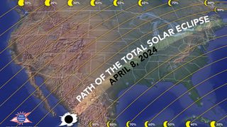
It's finally here: Today, (April 8) a total solar eclipse will pass across the skies North America, giving more than 33 million people living in 15 U.S. states a rare view of the totally-obstructed sun, and — weather permitting — a taste of some seriously strange eclipse phenomena .
If you’re wondering where the total and partial phases of the eclipse will be visible, the good news is that almost everyone in the contiguous U.S. will be able to see the celestial spectacle to some extent. But for a more detailed view of the eclipse’s path, take a look at these handy eclipse maps, courtesy of GreatAmericanEclipse.com.
Solar eclipse 2024 path of totality map
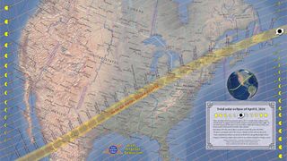
Totality is the moment that every eclipse-chaser lives for: The moment when the moon completely covers the sun’s face, resulting in a brief but eerie darkness in the daytime. The path of totality , shown in the map above, is the path of the moon’s shadow across Earth’s surface.
On Monday (April 8), totality will begin in Sinaloa, Mexico, then move northeast up to Texas, ultimately crossing 15 states before moving on to Canada. The states where totality will be visible are: Texas, Oklahoma, Arkansas, Missouri, Kentucky, Tennessee, Illinois, Indiana, Ohio, Michigan, Pennsylvania, New York, Vermont, New Hampshire and Maine — although Tennessee and Michigan will only be glanced by the moon's shadow.
Related: April 8 solar eclipse: What time does totality start in every state?
Viewers MUST be within the path of totality to witness the total phase of the eclipse; if you are off the path by even a mile, you will only see a partial eclipse, and miss out on the spooky daytime darkness. Furthermore, the closer you are to the center of the path of totality, the longer totality will last for you — up to a maximum duration of 4 minutes, 27 seconds in Torreón, Mexico.
Note: Totality is the ONLY TIME when it is safe to view the sun without protective eyewear like certified solar eclipse glasses . You must protect your eyes during the entire partial phase of the eclipse, no matter where you are.
Sign up for the Live Science daily newsletter now
Get the world’s most fascinating discoveries delivered straight to your inbox.
Solar eclipse 2024 partial eclipse map
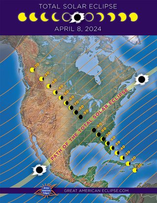
If you live in the U.S. and can’t make it to the path of totality, a partial eclipse still awaits you on April 8. The entire contiguous U.S. will have some view of the partial eclipse, ranging from 99% coverage of the sun just off the path of totality to about 15% coverage far to the northwest of the path.
The map above shows how much of the sun’s disk will be blocked from your location. Watching the partial phases of the eclipse — which last about an hour and 20 minutes before and after totality — means wearing protective eyewear at all times. Failure to do so could result in permanent eye damage, according to NASA .
If you want to experience the celestial spectacle but don’t have a pair of eclipse glasses handy, there are many other ways to safely enjoy the partial eclipse . These include making a homemade pinhole projector , using a pasta strainer to project the shadow of the moon onto the ground or watching one of the various eclipse live streams available.
2024 eclipse travel maps
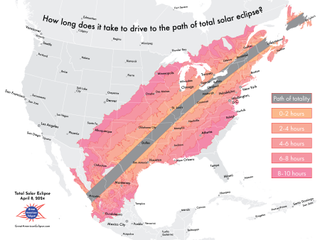
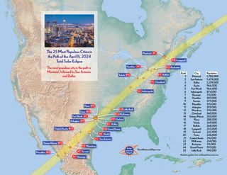
If you want to see totality but don’t live within the path, driving or taking public transit to a city within the path may be possible. The map above shows how far the drive is to the path of totality, based on where you’re coming from. Meanwhile, the map below shows the most populated cities within the path of totality — many of which are expected to be flooded with millions of eclipse tourists on April 8.
The biggest cities within the path of totality include: San Antonio, Dallas, Austin and Fort Worth in Texas; Indianapolis, Indiana; Hamilton and Montreal in Canada; and Torreón and Mazatlan in Mexico.
Wherever you are on April 8, we wish you clear skies and protected eyes during this rare, wondrous eclipse over North America.

Brandon is the space/physics editor at Live Science. His writing has appeared in The Washington Post, Reader's Digest, CBS.com, the Richard Dawkins Foundation website and other outlets. He holds a bachelor's degree in creative writing from the University of Arizona, with minors in journalism and media arts. He enjoys writing most about space, geoscience and the mysteries of the universe.
Why I watched the solar eclipse with my kids, a goose and 2,000 trees
No, you didn't see a solar flare during the total eclipse — but you may have seen something just as special
Uranus and Neptune aren't made of what we thought, new study hints
Most Popular
By Sascha Pare April 10, 2024
By Peter Ray Allison April 10, 2024
By Tom Metcalfe April 09, 2024
By Rebecca Sohn April 09, 2024
By Stephanie Pappas April 09, 2024
By Samantha Mathewson April 09, 2024
By Nicoletta Lanese April 09, 2024
By Sascha Pare April 09, 2024
By Emily Cooke April 09, 2024
By Harry Baker April 09, 2024
- 2 Watch live! The total solar eclipse has begun over North America.
- 3 Eclipse from space: See the moon's shadow race across North America at 1,500 mph in epic satellite footage
- 4 Superfast drone fitted with new 'rotating detonation rocket engine' approaches the speed of sound
- 5 Neolithic women in Europe were tied up and buried alive in ritual sacrifices, study suggests
- 2 Superfast drone fitted with new 'rotating detonation rocket engine' approaches the speed of sound
- 3 Neolithic women in Europe were tied up and buried alive in ritual sacrifices, study suggests
- 4 Pet fox with 'deep relationship with the hunter-gatherer society' buried 1,500 years ago in Argentina
- 5 No, you didn't see a solar flare during the total eclipse — but you may have seen something just as special
- Bahasa Indonesia
- Slovenščina
- Science & Tech
- Russian Kitchen
Discovering the historic neighborhoods of Perm
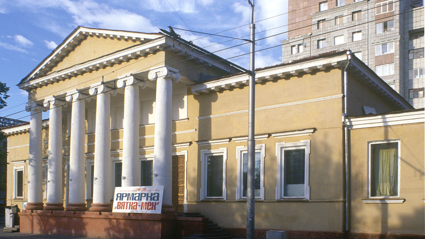
Perm. Building of the Nobility Assembly, Siberia Street 20. August 1999
The city of Perm, a major industrial and administrative center located just on the European side of the northern Urals, extends for miles along the high east bank of the Kama River. It was a destination of particular interest for Russian photographer and chemist Sergei Prokudin-Gorsky (see box text below), who visited the city on his first trip to the Ural Mountains in 1909.
Prokudin-Gorsky captured a series of riverfront vistas from the just-completed massive railroad bridge across the Kama. But he also took his tripod-mounted camera to the hillocks to the east of the city, where he photographed panoramic views of the central district that give a sense of Perm’s urban neighborhoods.
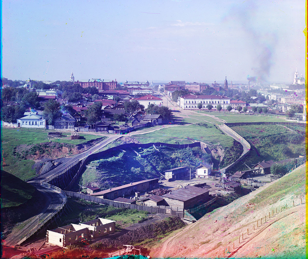
Panoramic view west from City Hillocks. From right: Monastery Street with Transfiguration Cathedral; Trading (now Soviet) Street with Church of St. Nicholas; Peter-Paul Street; Intercession (now Lenin) Street, with Church of Nativity of the Virgin. Summer 1909
My first visit to the Perm region occurred nine decades after Prokudin-Gorsky, in the summer of 1999. Subsequent trips, in 2014 and 2017, revealed a city marked by major new construction.
The name “Perm” is documented as early as the 12th-century chronicle “Tale of Bygone Years” and is apparently derived from Finno-Ugric words pera ma , meaning "distant land." In the medieval period "Perm" designated territory in the northern Urals controlled by the economic power of Novgorod, whose hunters and traders reaped the bounty of its valuable furs. By the 17th century, much of the area belonged to the vast Stroganov holdings in the northern Urals.
Founded for industry
The settlement of Perm originated in the early 18th century as part of the quest by Peter the Great to exploit ore deposits in the Ural Mountains. These raw materials provided secure sources of essential industrial-grade metals needed above all for the army.
The guiding force in developing this area was Vasily Tatishchev (1686-1750), one of Russia's early professional historians. A scholar with a gift for practical activity, Tatishchev admired Peter the Great and was an influential proponent of the central role of autocrat and state in Russian history.
During the 1720s, Tatishchev established settlements at mines, smelters, and metal-working plants throughout the Urals, including Yekaterinburg. In 1720, he chose the 17th-century village of Yegoshikha, located near the small Yegoshikha River, a tributary of the Kama. The stream is hardly visible in the ravine in the foreground of Prokudin-Gorsky’s rich panoramas.
Construction began on the main Yegoshikha factory on May 4, 1723, which is considered Perm’s founding date. The name “Perm,” however, was officially adopted only in 1781 after a command by Catherine the Great that transformed the factory settlement into an administrative center for the Urals.
Because of its favorable location within the Volga River basin, Perm during the 19th century developed into a transportation center for salt and other minerals, as well as metal ore and the products of metal factories throughout the western Ural Mountains. In 1846 regular steamboat service appeared on the Kama.
Expansion and development
Much of Perm burned during a fire in 1842, but the town quickly recovered. In 1863, Perm was included in the main Siberian highway, and in 1878, construction was completed on the first phase of the Urals Railroad from Perm to Ekaterinburg, part of a railroad construction boom that culminated in the early 20th century with the completion of the TransSiberian Railway.
Perm’s growth at the turn of the 20th century was reflected in Prokudin-Gorsky’s overviews of the central city, with its belching smokestacks. Despite sweeping changes in the century following Prokudin-Gorsky’s visit, several of the buildings captured in his photographs remain.
A historical record in images
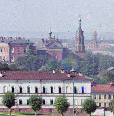
Perm. Detail of view west from City Hillocks. Center: Bell tower and Church of St. Nicholas, attached to the Mariinsky Women’s High School. Right background: central fire station & watchtower. Summer 1909
The photograph richest in detail is a panoramic view taken due west from the city hillocks located to the east of the central district. On the far right is Monastery Street with its dominant landmark, the Transfiguration Cathedral, visible through the haze of industrial smoke. This street links a series of monuments surveyed in my previous Perm article .
The next thoroughfare to the left was Trading (now Soviet) Street. Its main landmark (apart from a belching smokestack) is the bell tower and cupolas of the Church of St. Nicholas, built in 1895-99 to commemorate the marriage of soon-to-be-emperor Nicholas and Alexandra in 1894. The church was attached to the large Mariinsky Women’s High School.
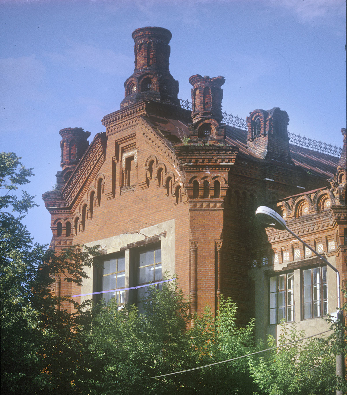
Church of St. Nicholas, attached to the Mariinsky Women’s High School. (Cupolas & bell tower demolished in Soviet period.) August 1999
With the establishment of Soviet power, the St. Nicholas bell tower and cupolas were demolished, and the entire building was converted for the use of the Agriculture Academy (now a university). My photographs from 1999 reveal that most of the basic red brick structure has survived.
Dimly visible just beyond is the red brick watch tower of the central Perm fire station. Completed in 1883, the tower and its surrounding depot are still maintained in their original function, as my 1999 photograph shows.
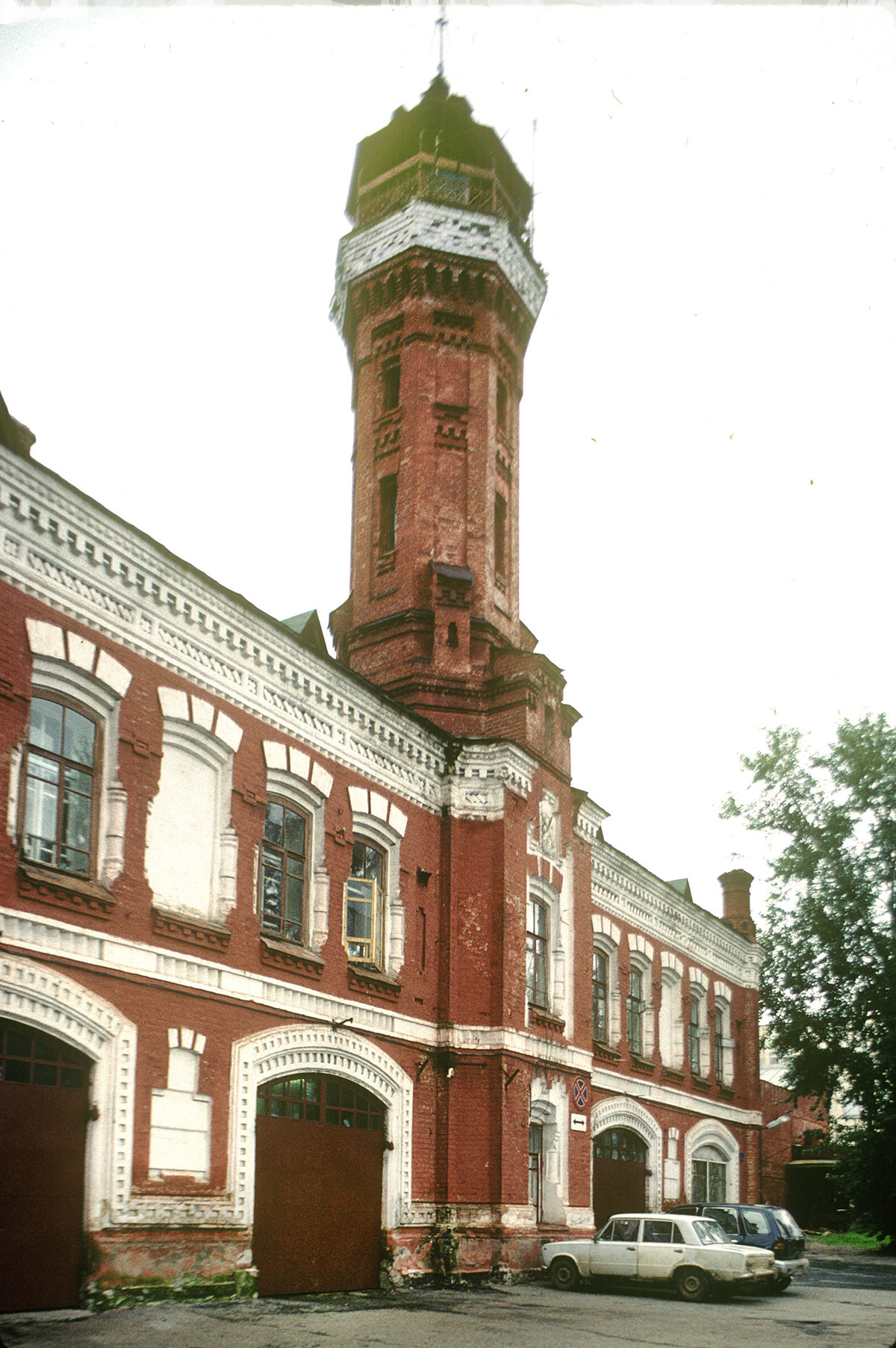
Central fire station & watchtower. August 1999
In the center of Prokudin-Gorsky’s photograph is a boulevard whose segments were called Great Nobility Street and Peter-Paul Street, the latter named after the Cathedral of Sts. Peter and Paul, a sliver of whose bell tower is at the photograph’s right edge. Built in 1757-64, it is the oldest surviving brick church in Perm. I have included my black-and-white photograph of the cathedral. (Its bell tower, destroyed in the Soviet period, has not yet been rebuilt.) Renamed Communist Street during the Soviet period, the entire boulevard is now called Peter-Paul Street.
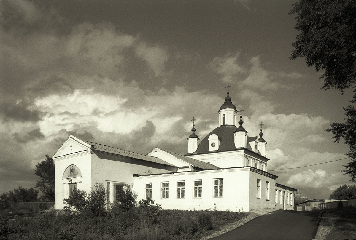
Cathedral of St. Peter & Paul, southwest view. (Bell tower demolished in Soviet period.) August 1999
On the left of Prokudin-Gorsky’s panorama is Intercession (now Lenin) Street. In the distance is the bell tower steeple and dome of the Church of the Nativity of the Virgin (Lenin Street 48), built with merchant donations over a long period from 1787 to 1816.
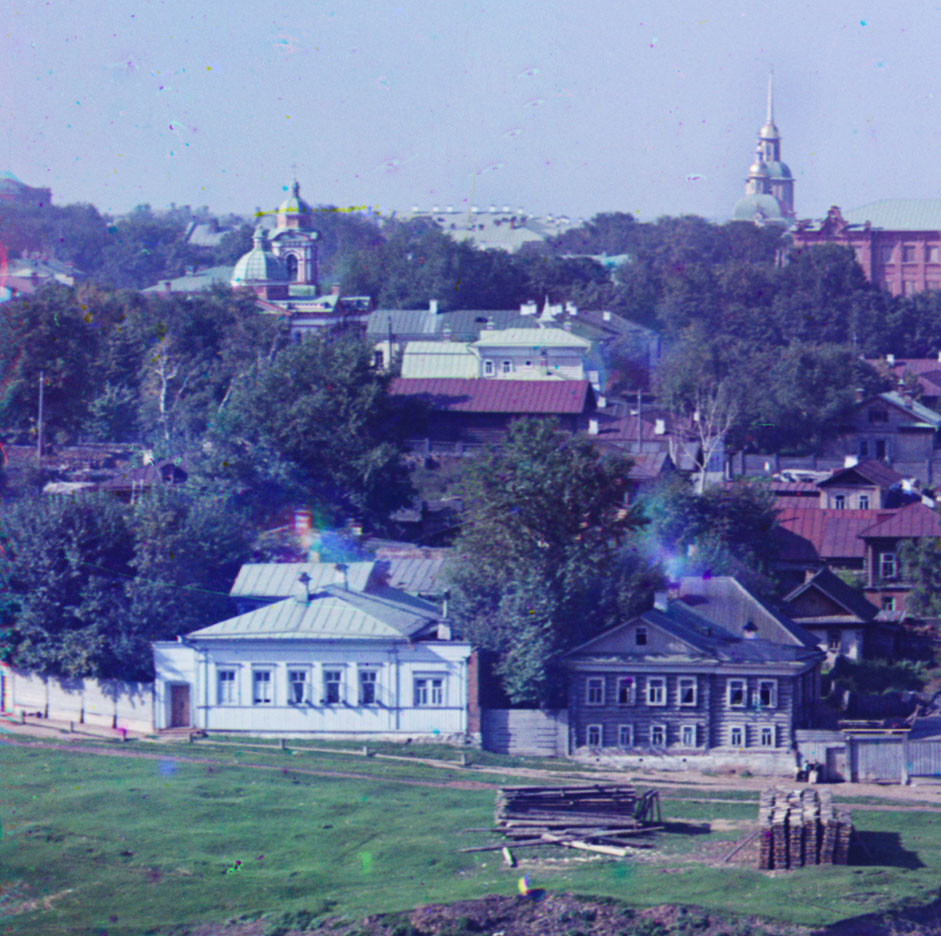
Perm. Detail of view west from City Hillocks. Intercession (now Lenin) Street. Left: Church of St. Mary Magdalene. Right: Church of Nativity of the Virgin. Summer 1909
This second brick church in Perm was closed in 1928, its bell tower and cupolas were demolished and the structure was converted into a student dormitory. My photograph from 2014 shows the restored church without the bell tower, which was rebuilt at the end of the year.
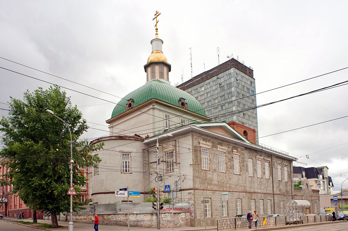
Church of Nativity of the Virgin (Lenin Street 48), northeast view. Its bell tower, demolished during Soviet period, had not yet been rebuilt at time of this view. It has now been rebuilt. June 2014
On the far left, two small green domes indicate the Church of St. Mary Magdalene (Lenin Street 11), built in a neoclassical style in 1889-92 as part of a large orphanage. Prokudin-Gorsky’s took two close views that are especially valuable in view of the structure’s subsequent history. In the 1930s the cupola and bell tower were demolished, and a third story was added — as seen in my 1999 photograph. The building now serves as the Institute of Ecology and Genetics.
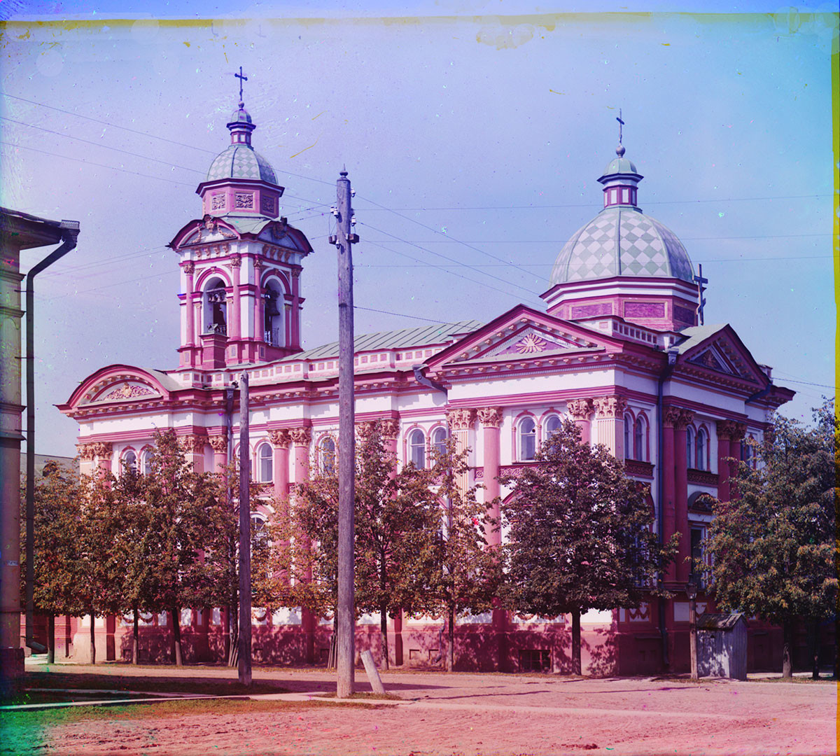
Church of St. Mary Magdalene, southeast view. Summer 1909
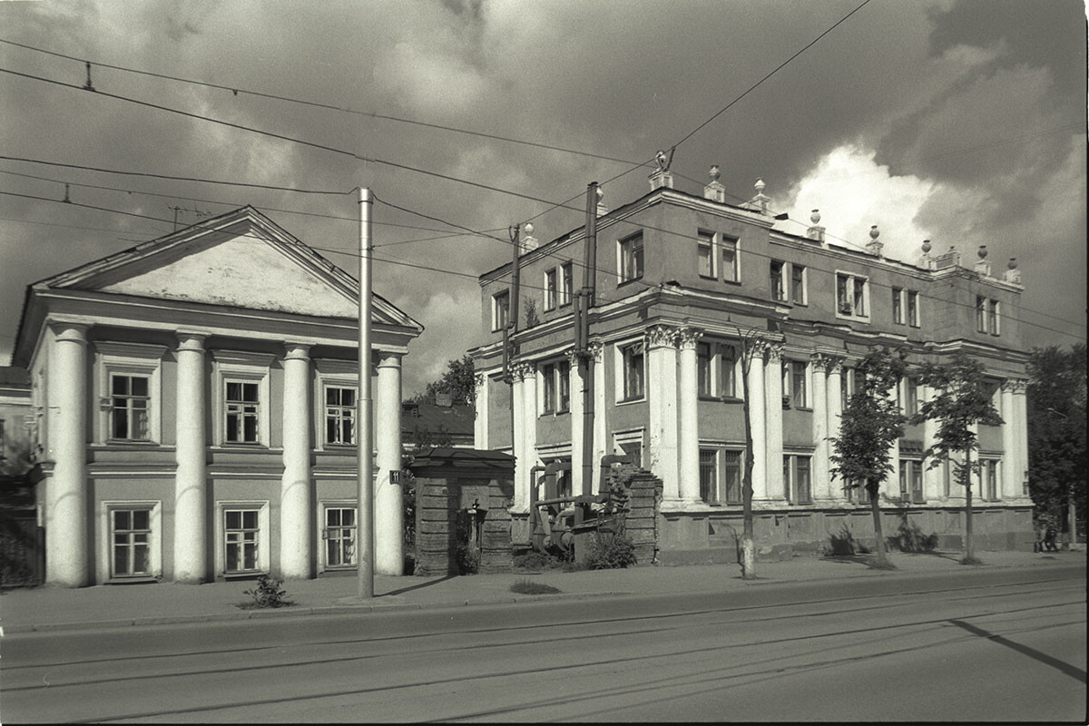
Former Church of St. Mary Magdalene. Dome & bell tower demolished with addition of third floor in 1930s. Now used for Institute of Ecology and Genetics (Lenin Street 11). August 1999
Revelations of past splendor
A bit farther down the same block is the splendid Gribushin mansion, hidden by the trees in Prokudin-Gorsky’s photograph. Originally built in 1895-97, the house was rebuilt in 1905 in a lavish baroque manner for the merchant Sergey Gribushin. Referred to in Boris Pasternak's novel Doctor Zhivago as the "house with statues" (in the town of “Yuriatin”), the mansion serves as the headquarters of the Urals Division of the Russian Academy of Sciences.
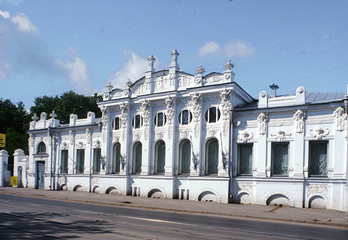
Gribushin mansion. Now headquarters of Urals Division of the Russian Academy of Sciences (Lenin Street 13). August 1999
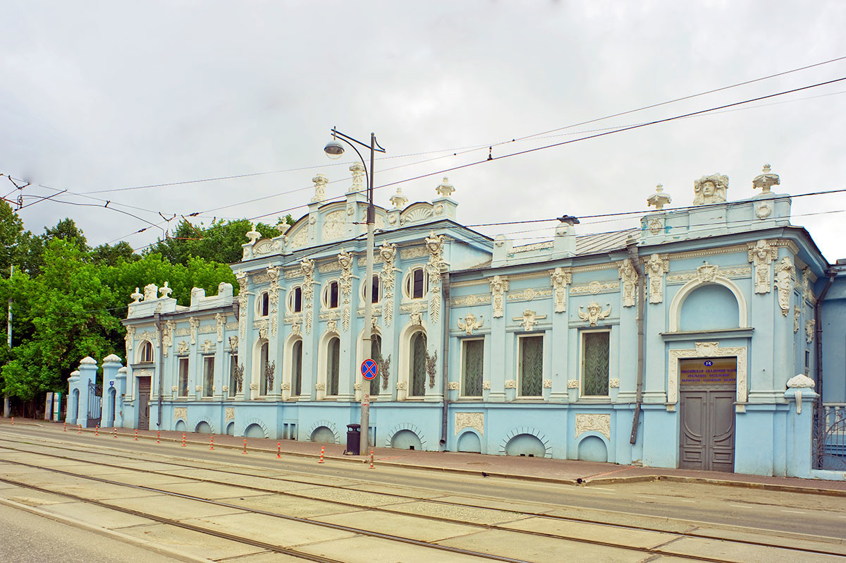
Gribushin mansion (repainted). June 2014
And if Prokudin-Gorsky and his assistants had maneuvered his bulky camera just three more blocks, to the intersection of Siberia and Ascension (now Lunacharsky) Streets, they would have photographed two more cultural monuments. On one side is the elegant neoclassical building of the Nobility Assembly, built by Ivan Sviyazev in 1832-37.
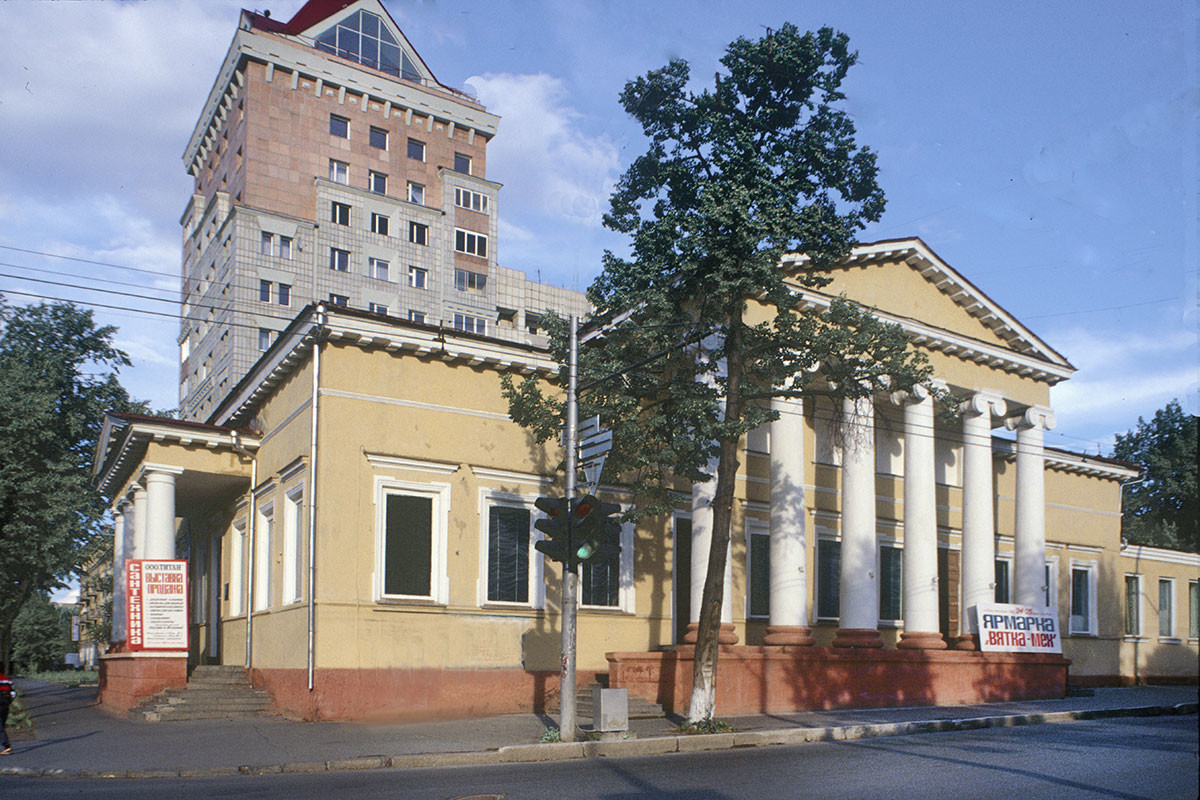
Perm. Building of the Nobility Assembly, Siberia Street 20. August 21, 1999
On the other side of Siberia Street is the house built in 1852 and acquired in 1862 by Pavel Diaghilev, grandfather of the renowned impresario Serge Diaghilev, who spent much of his childhood there.
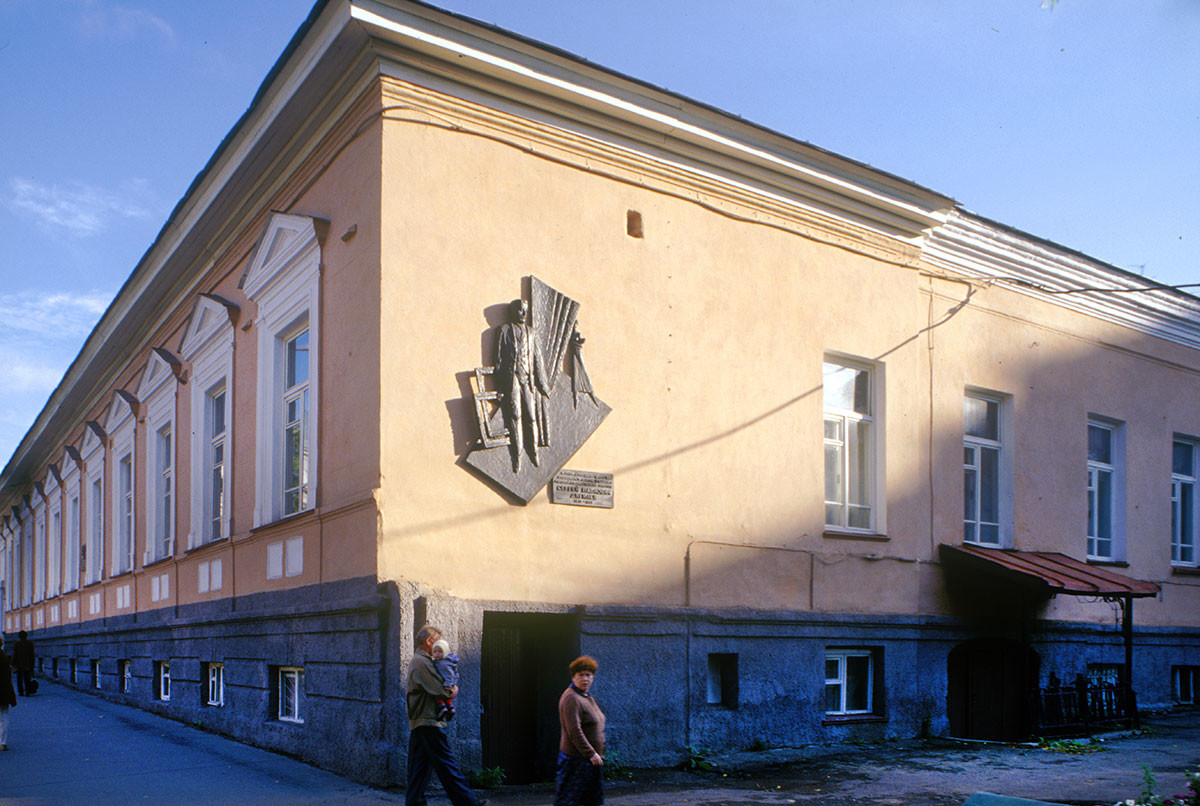
Diaghilev house (Siberia Street 33). Childhood home of Serge Diaghilev. August 1999
Prokudin-Gorsky’s photographs of pre-revolutionary Perm convey an invaluable sense of a provincial Russian city, with its mixture of traditional architecture and rapid industrial expansion. These richly detailed views of the city’s neighborhoods have become a unique record of a historic milieu that fades with each passing year.
In the early 20th century the Russian photographer Sergei Prokudin-Gorsky devised a complex process for color photography. Between 1903 and 1916 he traveled through the Russian Empire and took over 2,000 photographs with the process, which involved three exposures on a glass plate. In August 1918, he left Russia and ultimately resettled in France where he was reunited with a large part of his collection of glass negatives, as well as 13 albums of contact prints. After his death in Paris in 1944, his heirs sold the collection to the Library of Congress. In the early 21st century the Library digitized the Prokudin-Gorsky Collection and made it freely available to the global public. A few Russian websites now have versions of the collection. In 1986 the architectural historian and photographer William Brumfield organized the first exhibit of Prokudin-Gorsky photographs at the Library of Congress. Over a period of work in Russia beginning in 1970, Brumfield has photographed most of the sites visited by Prokudin-Gorsky. This series of articles juxtaposes Prokudin-Gorsky’s views of architectural monuments with photographs taken by Brumfield decades later.
If using any of Russia Beyond's content, partly or in full, always provide an active hyperlink to the original material.
to our newsletter!
Get the week's best stories straight to your inbox
- Perm: Lord of the Northern Urals
- St. Nicholas Nadein: One of Yaroslavl’s great 17th-century churches
- U.S. professor continues photographic legacy of Prokudin-Gorsky in new book
This website uses cookies. Click here to find out more.
Maps of the April 2024 Total Solar Eclipse
By Jonathan Corum
On April 8, the moon will slip between the Earth and the sun, casting a shadow across a swath of North America: a total solar eclipse.
By cosmic coincidence, the moon and the sun appear roughly the same size in the sky. When the moon blocks the glare of the sun, the sun’s outer atmosphere, or corona, will be briefly visible.
Below are several maps of the eclipse’s path as well as images of what you might experience during the event.
Where Can I See the Total Eclipse?
The eclipse will begin at sunrise over the Pacific Ocean, then cut through Mexico and cross the United States from Texas to Maine. Most of North America will see a partial eclipse, but viewers within the deepest shadow — a band sliding from Mazatlán, Mexico, to the Newfoundland coast near Gander, Canada — will experience a total solar eclipse.
Percentage of
the sun obscured
during the eclipse
Indianapolis
Little Rock
San Antonio
Viewers inside the path of the total eclipse may notice a drop in temperature , a lull or shift in the wind , the appearance of bright planets in the sky, and the quieting of birds and other wildlife.
Many cities lie inside the path of the total eclipse, as shown below, the width of which varies from 108 miles to 122 miles.
5:13 p.m. NDT
20% partial eclipse
NEWFOUNDLAND
SASKATCHEWAN
Fredericton
4:33 p.m. ADT
3:26 p.m. EDT
3:20 p.m. EDT
Minneapolis
3:18 p.m. EDT
3:13 p.m. EDT
San Francisco
90% partial eclipse
3:05 p.m. EDT
Los Angeles
1:51 p.m. CDT
1:40 p.m. CDT
1:33 p.m. CDT
12:16 p.m. CST
12:12 p.m. CST
11:07 a.m. MST
Mexico City
EL SALVADOR
12:23 p.m. CST
1:36 p.m. CDT
3:09 p.m. EDT
3:27 p.m. EDT
Explore our interactive cloud outlook for eclipse viewing times and average cloud data at your location.
What Will I See?

A composite image of the 2017 solar eclipse over Madras, Ore.
Aubrey Gemignani/NASA
If the sky is clear, viewers in the path of the total eclipse should see a “diamond ring” effect a few seconds before and after the total eclipse, as the edge of the sun slips in and out of view.

The “diamond ring” effect during the 2017 solar eclipse.
Rami Daud/NASA, Alcyon Technical Services
The sun’s outer atmosphere, or corona, is normally hidden by the sun’s glare. These tendrils and sheets of gas, heated to a million degrees Fahrenheit or more, are in constant motion and shaped by the sun’s swirling magnetic field.

The sun’s corona during the 2017 solar eclipse.
The sun is relatively active this year and is nearing the expected peak of its 11-year solar cycle . Researchers at Predictive Science are using data about the sun’s magnetic field to predict and model a dramatic corona for the April eclipse.

A prediction of how the sun’s corona might appear during the April 8 total eclipse.
Predictive Science
What Colors Should I Wear?
As the sky darkens, light-sensitive cells in human eyes become more sensitive to blue and green hues than to reds and oranges. This shift in color perception is known as the Purkinje effect , after a 19th-century Czech scientist, and is typically seen at twilight.

Watching the 2017 total eclipse at Southern Illinois University.
Andrea Morales for The New York Times
To take advantage of the Purkinje effect, Solar Eyeglasses suggests wearing green clothes or a contrasting combination of greens and reds. Blue-green colors (shorter wavelengths) will appear brighter, while red colors (longer wavelengths) will appear to recede into the darkness.
What If I Miss It?
The next two total solar eclipses in the United States won’t occur until 2044 and 2045 . But eclipse chasers might catch one in 2026 in Greenland, Iceland and Spain; 2027 along the coast of Northern Africa; 2028 in Australia and New Zealand; or 2030 across Southern Africa and Australia.

A Total Solar Eclipse Is Coming. Here’s What You Need to Know.
These are answers to common questions about the April 8 eclipse, and we’re offering you a place to pose more of them.
By Katrina Miller

What’s the Cloud Forecast for Eclipse Day? See if the Weather Is on Your Side.
April 8 could be your best opportunity to see a total solar eclipse for decades. But if clouds fill the sky, you may miss the spectacle.
By Josh Katz, K.K. Rebecca Lai and William B. Davis
- Share full article
Advertisement
When will solar eclipse reach your town? These maps show path's timing, how long it lasts.
Hundreds of cities in 13 u.s. states fall directly on the april 8 eclipse's path of totality as the moon blocks the sun's disc and ushers in darkness. these interactive maps offer a closer look..

Come Monday, millions of Americans from Texas to Maine will stop what they're doing to step outside and spend a few minutes gazing skyward .
Few celestial events have the power to capture our collective attention the way this upcoming total solar eclipse has managed to do. And for those making time to witness it, two questions are bound to be on their mind : Will totality reach my area and if so, how long will the resulting darkness last?
Most people across the country are bound to experience the eclipse in some form, but only 13 states fall directly on the path of totality, where the moon will appear large enough to shield all but the sun's outermost layer, the corona.
As you make your eclipse-viewing plans, these interactive maps should help you chart the time and duration for when totality will occur in cities along the path.
Solar eclipse experiment: Here's why NASA is launching 3 sounding rockets into space during the total solar eclipse
Total solar eclipse path of totality map
The 115-mile-wide path of totality will pass from southwest to northeast over portions of Mexico the United States and Canada.
Mexico's Pacific coast will be the first location in continental North America to experience totality, which will occur at about 11:07 a.m. PDT, according to NASA .
As the moon's shadow travels northeast, totality in the U.S. will begin at 1:27 p.m. CDT in Eagle Pass, Texas. From there, the path will cut diagonally across the country before ending around 3:35 p.m. EDT in Lee, Maine.
Remember: If you plan to witness the eclipse, proper eyewear is a must until the eclipse reaches totality, then it can be viewed with the naked eye.
Here's a map of some of the larger cities in each of the 13 states on the path to show how the duration of totality will vary:
Cities, states on the path of totality
All told, nearly 500 cities in 13 U.S. states are located on the eclipse's path of totality. Here are some of the major cities in each of the 13 states:
- Dallas and San Antonio, Texas
- Idabel, Oklahoma
- Poplar Bluff, Missouri
- Little Rock, Arkansas
- Paducah, Kentucky
- Indianapolis and Evansville, Indiana
- Carbondale, Illinois
- Cleveland and Toledo, Ohio
- Buffalo, Rochester and Syracuse, New York
- Burlington, Vermont
- Lancaster, New Hampshire
- Caribou, Maine
- Erie, Pennsylvania
This interactive map provides a closer look at cities along the path, when totality will arrive there and how long totality will last:
Eclipse watch parties, festivals
Such a rare event is sure to attract skygazing tourists unlucky enough to live outside the path of totality. Fortunately, many cities that will experience the total eclipse are planning plenty of festivities for tourists and locals alike.
This map , courtesy of Kristian Campana at festivalguidesandreviews.com , includes locations of watch parties, music festivals and more all tied to the eclipse's arrival:
2024 total solar eclipse interactive map with zip code search
Perhaps the easiest way to see how the eclipse will impact your city or town, is to put your zip code into USA TODAY's interactive eclipse map .
Eric Lagatta covers breaking and trending news for USA TODAY. Reach him at [email protected]
Arizona Supreme Court rules a near-total abortion ban from 1864 is enforceable
PHOENIX — The Arizona Supreme Court ruled Tuesday that a 160-year-old near-total abortion ban still on the books in the state is enforceable, a bombshell decision that adds the state to the growing lists of places where abortion care is effectively banned.
The ruling allows an 1864 law in Arizona to stand that made abortion a felony punishable by two to five years in prison for anyone who performs one or helps a woman obtain one.
The law — which was codified in 1901, and again in 1913 — outlaws abortion from the moment of conception but includes an exception to save the woman’s life.
That Civil War-era law — enacted a half-century before Arizona even gained statehood — was never repealed and an appellate court ruled last year that it could remain on the books as long as it was “harmonized” with a 2022 law, leading to substantial confusion in Arizona regarding exactly when during a pregnancy abortion was outlawed.

The decision — which could shutter abortion clinics in the state — effectively undoes a lower court’s ruling that stated that a more recent 15-week ban from March 2022 superseded the 1864 law.
The Arizona Supreme Court said it would put its decision on hold for 14 days, writing that it would send the case back to a lower court so that court could consider “additional constitutional challenges” that haven’t yet been cleared up.
Attorney General Kris Mayes, a Democrat, said moments after the ruling that she would not enforce the law.
“Let me be completely clear, as long as I am Attorney General, no woman or doctor will be prosecuted under this draconian law in this state,” Mayes said in a statement, adding that the decision was “unconscionable” and “an affront to freedom.”
Democrats all the way up to President Joe Biden also blasted the ruling.
“Millions of Arizonans will soon live under an even more extreme and dangerous abortion ban, which fails to protect women even when their health is at risk or in tragic cases of rape or incest,” Biden said in a statement. He called the ban “cruel” and “a result of the extreme agenda of Republican elected officials who are committed to ripping away women’s freedom” and vowed to “continue to fight to protect reproductive rights.”
Vice President Kamala Harris announced shortly after the ruling that she would travel to Arizona on Friday “to continue her leadership in the fight for reproductive freedoms."
Responding to questions from NBC News about the Arizona ruling, a spokesperson for Donald Trump's campaign referred only to the former president's comments on Monday that abortion restrictions should be left to states.
“President Trump could not have been more clear. These are decisions for people of each state to make," Trump campaign national press secretary Karoline Leavitt said.
Arizona Gov. Katie Hobbs called for the GOP-controlled Legislature, which is currently in session, to repeal the 1864 ban, though there was no immediate indication that Republican lawmakers in either chamber would take up such an effort.
"We are 14 days away from this extreme ban coming back to life," Hobbs, a Democrat, said at a press conference. "It must be repealed immediately."
While Hobbs said she was "sure" reproductive rights advocates would appeal the ruling in the 14-day window they were given, she also suggested that the best avenue to counter the ruling would be for voters to support abortion rights on the November ballot. A separate, ongoing suit would allow for abortion providers to continue providing services through the 15th week of pregnancy for another 45 days.
"It is more urgent than ever that Arizonans have the opportunity to vote to enshrine the right to abortion in our constitution this November. I’m confident that Arizonans will support this ballot measure, and I’m going to continue doing everything in my power to make sure it is successful," Hobbs said.
In a 4-2 ruling, the court’s majority concluded that the 15-week ban “does not create a right to, or otherwise provide independent statutory authority for, an abortion that repeals or restricts” the Civil War-era ban “but rather is predicated entirely on the existence of a federal constitutional right to an abortion since disclaimed” by the 2022 Dobbs decision that overturned Roe v. Wade.
“Absent the federal constitutional abortion right, and because” the 2022 law "does not independently authorize abortion, there is no provision in federal or state law prohibiting” the 1864 ban.
They added that the ban “is now enforceable.”
Tuesday’s ruling is the latest chapter in a decadeslong saga of litigation in the battleground state over abortion rights.
Reproductive rights groups had sued to overturn the 19th century law in 1971. But when the Roe decision came down in 1973, a lower state court ruled against those groups and placed an injunction on the 1864 ban that remained in effect until the Dobbs decision.
In March 2022, Republican lawmakers in the state enacted the 15-week trigger ban, which, months later — after the Dobbs decision — snapped into effect. The law makes exceptions for medical emergencies but not for rape or incest.
Litigation resumed after that decision as lawmakers on both sides of the issue sought clarity on whether to enforce the 1864 near-total ban or the 2022 15-week ban.
A state appellate court initially ruled that both the 1864 and 2022 laws could eventually be “harmonized,” but also said that the 15-week ban superseded the near-total abortion ban and put on hold large parts of the older law.
The decision also sent shockwaves through the reproductive rights community in Arizona and nationally.
Angela Florez, the president of Planned Parenthood Arizona, one of the state's remaining abortion care providers, said her group would now only be able to provide abortion care through the 15th week of pregnancy — and only "for a very short period of time."
The issue, however, could soon be in the hands of voters.
Abortion rights groups in the state are likely to succeed in their goal of putting a proposed constitutional amendment on the November ballot that would create a “fundamental right” to receive abortion care up until fetal viability, or about the 24th week of pregnancy.
If voters approved the ballot measure, it would effectively undo the 1864 ban that now remains law in the state. It would bar the state from restricting abortion care in situations where the health or life of the pregnant person is at risk after the point of viability, according to the treating health care professional.
That ballot effort is one of at least 11 across the country that seek to put the issue directly in the hands of voters — a move that has the potential to significantly boost turnout for Democratic candidates emphasizing the issue.
In 2024, that could factor heavily into the outcome of both the presidential and U.S. Senate races in Arizona. Biden, whose campaign is leaning heavily into reproductive rights, won the state by just over 10,000 votes four years ago. And the Senate race features a tough battle to fill the seat held by the retiring independent Sen. Kyrsten Sinema, most likely between Democrat Ruben Gallego and Republican Kari Lake.
During her unsuccessful 2022 run for governor in Arizona, Lake said she supported the 1864 law, calling it “ a great law that’s already on the books .” But Lake now says she opposes the 1864 law , as well as a federal abortion ban, while also acknowledging that her own views regarding state policy conflict with some voters’ preferences.
In a statement following the decision, Lake said she opposed the ruling, adding that "it is abundantly clear that the pre-statehood law is out of step with Arizonans." She called on state lawmakers to "come up with an immediate common sense solution that Arizonans can support."
"Ultimately, Arizona voters will make the decision on the ballot come November," she added.
Gallego, who is backed by several reproductive rights groups, has said he supports the ballot measure. As a member of the U.S. House, he is among the co-sponsors of the Women’s Health Protection Act, which would create federal abortion protections.
In a video posted to X after the ruling, Gallego said he would, with reproductive rights supporters, "fight all the way to November so we can get abortion rights back for women in Arizona."
Other Republicans in the state who’d previously expressed robust support for Roe being overturned joined Lake in condemning the ruling. Reps. Juan Ciscomani and David Schweikert , who both face tough re-elections this fall, both called on state lawmakers to address the issue “immediately.”
The ruling Tuesday — the second in a swing state on the issue in as many weeks — further highlights the already prominent role abortion rights will play in Arizona and across the country.
Last week, the Florida Supreme Court upheld a 15-week ban on abortion in the state, which effectively meant that a six-week abortion ban, with exceptions for rape, incest and the life of the woman, that Gov. Ron DeSantis signed into law last year will take effect. The state's high court also allowed a proposed amendment that would enshrine abortion protections in the state constitution to appear on the November ballot.
Tuesday's decision, while jarring to reproductive rights groups, wasn’t entirely unexpected. All seven justices on the Arizona Supreme Court were appointed by Republican governors, and during opening arguments in December, they aggressively, but civilly, quizzed attorneys on both sides about the fact that the 15-week ban enacted last year did not feature any language making clear whether it was designed to repeal or replace the 1864 ban.
Only six justices participated in Tuesday’s decision, however, after Justice Bill Montgomery — who previously accused Planned Parenthood of practicing “generational genocide” — recused himself. (The court’s chief justice did not appoint another judge to take the spot, which is an option under Arizona law.)
The abortion landscape in Arizona has been uniquely confusing since Roe v. Wade was overturned.
While the 1864 law had been on hold after the Supreme Court’s 1973 Roe decision, then-Arizona Attorney General Mark Brnovich, a Republican, successfully sued in 2022 to have that injunction lifted following the overturning of Roe, putting the ban back into effect — though a higher court put that ruling on hold.
But after Mayes succeeded Brnovich as attorney general, she announced that she would not enforce the 1864 ban.
That led to suits from anti-abortion groups seeking enforcement of the ban, which ultimately led to the case making its way up to the state Supreme Court.
Adam Edelman is a political reporter for NBC News.
Alex Tabet is a 2024 NBC News campaign embed.

IMAGES
VIDEO
COMMENTS
Make your own interactive visited countries map. Just select the countries you visited and share the map with your friends.
Track your travel, mark visited countries and create your own world map. Plan your travel adventures, add bucket list destinations to your wishlist and share your travel goals with your friends and family using our interactive map tool.
Add your travel destinations on a map, select your transport modes, visualize and share your itinerary for free. My itinerary This is a free demo version of our mapping software. Create an account to save your current itinerary and get access to all our features. ...
Track your experiences by country such as where you've gone golfing, snorkelling/diving, skiing, wine tours and others. Keep up with your travel life goals by selecting all the countries of the world that you want to visit. Add travel journal notes by country of your travel dates, points of interest or personal memories.
Use the maps available to mark countries and places you have travelled. It is easy to make your own travel map showing places you have travelled or you plan to visit with MapChart. In this post, we will see some variations of such maps from users of the website. First off, and one of the most popular options, a travel map that shows counties ...
Travel Map Creator. Please click on countries on the map or select below via checkboxes to mark your visited countries. You can select a map style by clicking on the appropriate button below. ... Mark All Countries Visited Clear Visited Countries. All A-D E-H I-L M-P Q-T U-Z. Filter: Afghanistan; Albania; Algeria; American Samoa; Andorra ...
Use Wanderlog to share your itinerary with tripmates, friends, and families and collaborate in real time, so everyone stays in the loop. Plan your road trip or vacation with the best itinerary and trip planner. Wanderlog travel planner allows you to create itineraries with friends, mark routes, and optimize maps — on web or mobile app.
Skratch lets you plan, track and share your travel life with personalized maps. Track your visited countries and states. Create a bucket list. See real time travel restrictions. ... Mark the places you've been. Create your own scratch map in seconds. Add over 18k countries, territories, cities, regions, provinces and states ...
About this app. Unlock the world with Skratch, your essential travel companion! Mark countries, cities & regions you've been. Create a bucket list. Plan trips with real-time travel info. Skratch lets you plan, track and share your travel life with personalized maps. Get started today on the top scratch map and travel inspiration app. Mark all ...
Customize your travel map with pins, using various pin colors and map styles! Explore. With personalized travel statistics explore how much of the world you have discovered. GALLERY App Screenshots. Screenshots from: Pin Traveler App Version 2.7.5 (iOS) ... I use this to mark my products ...
FULLY CUSTOMIZABLE. -Select different colors or design your own based on your travel type. -Pick fully accessible, high contrast colors for your map. -Dark mode is supported to make the app easier to use while taking a red eye flight. -Adjust the sovereignty for disputed territories.
Personalized maps. Use the map editor to add your points, trace your lines or import GPS files. Choose the map style, the marker icons and the line colors (defined by your transport modes). No technical knowledge required.
Visited countries map. Use this tool to create beautiful interactive maps of the places you have been in the world or within any country. Create smooth animations or static images. Embed them into any website or blog. Share on Facebook, Twitter, TikTok, Pinterest, or any other social network. Awe your friends and followers with a cool-looking ...
Visited Countries Map; Visited States Map; Select states you visited. States; Set map parameters Clear map & reset colors. Map width. Map height. Zoom function. Water. Visited states. Unvisited states. Hover states. Border. Hover border. Share your map on: Facebook Twitter. or on other networks: Copy HTML
Mark, showcase and count the countries you have visited - your travel story, your way. 0. Number of Countries visited. 0%. of the World traveled ... our scratch map feature allows you to mark the countries you've been to, creating a personalized travel history that showcases your global experiences. Easily navigate the map, select countries ...
This is your easy my country counter, and interactive map of places visited. Keep track of how many countries and places visited and plan your next trip with our interactive map with visited countries. Whether you're a seasoned traveler or just starting to explore the world, our map maker is a convenient and fun way to document your travels.
All inclusive, top of the line Original Personalized World Traveler Map. It is the gold standard push-pin travel map! It's a... Learn more. $ 179.00. Quantity. Add to Cart. Map Your Travels with personalized traveler maps complete with push pins to track your travels. Travel Quest Posters and travel map accessories also available.
MapFling: easily share free maps with your own custom markers! MapFling is a free Web 2.0 AJAX online service which lets you: Free Maps Bring up a map of nearly any city or country in the world (a road map, aerial photogaphy, a satellite image, or a hybrid map), Mark Custom Points on Map with your own Annotation or Description
Find local businesses, view maps and get driving directions in Google Maps.
Perm is the most Eastern city of Europe, and therefore its province is often referred to as Eurasia. Having a population of 1 million, Perm' is one of the largest cities in Russia and the second largest in the Urals. The city was formerly called Molotov, after the minister of foreign affairs during Joseph Stalin's ruling.
Discover Perm, Russia in this map from travelario.com with 7 locations. The most exciting sights, the best hotels, a diverse nightlife, recommended restaurants and much more. Updated constantly, free and available for desktop/smartphone/tablet.
Meanwhile, the map below shows the most populated cities within the path of totality — many of which are expected to be flooded with millions of eclipse tourists on April 8. The biggest cities ...
Chusovoy, city, Perm oblast (province), west-central Russia. It is situated in the mid-Ural Mountains along the Chusovaya River at the inflow of the Usva. Founded in 1879 as an ironworks, it became a city in 1933. Ironworks and steelworks are located there, and ferroalloys and high-quality steels.
My first visit to the Perm region occurred nine decades after Prokudin-Gorsky, in the summer of 1999. Subsequent trips, in 2014 and 2017, revealed a city marked by major new construction.
Updated April 5, 2024. On April 8, the moon will slip between the Earth and the sun, casting a shadow across a swath of North America: a total solar eclipse. By cosmic coincidence, the moon and ...
Total solar eclipse path of totality map. The 115-mile-wide path of totality will pass from southwest to northeast over portions of Mexico the United States and Canada. Mexico's Pacific coast will ...
A total solar eclipse occurs when the moon passes between Earth and the sun, completely blocking the sun's face. Those within the path of totality will see a total solar eclipse. People outside ...
The Arizona Supreme Court ruled Tuesday that a 160-year-old near-total abortion ban still on the books in the state is enforceable, a bombshell decision that adds the state to the growing lists of ...
Venice is commemorating its most famous son, Marco Polo, with a major exhibition to mark the 700th anniversary of his death. The show, which opened in early April, features excavated finds, maps ...