Microsoft Streets and Trips 2022 Alternative
Jul 31, 2020
It’s 2022 and nearly everyone has access to a personal GPS on their mobile device — but let’s not forget that digital maps are a recent invention. With the introduction of MapQuest in 1996, online personal mapping slowly became accessible to the public. This not just revolutionized personal navigation — it transformed the way industries like field sales operated.
But before Waze, Google Maps, and even TomTom existed — there were five friends from Surrey, England that built an overnight success software called Autoroute. Massively popular, it was eventually downloaded by half of the computers in the UK. In the late 90s, it was acquired by Microsoft and distributed in North America as Streets and Trips in 2000 .
14 years later, it suddenly disappeared from the market. So what happened?

What Was Microsoft Streets and Trips?
Microsoft Streets and Trips was a mapping and routing program that helped lay the foundation for personal GPS systems. Now discontinued, it was a computer program that mapped out streets, businesses and places of interest — as well as displayed pins on a map and built multi-stop routes from place to place.
In later versions, it introduced features we are familiar with like weather considerations, traffic monitoring and construction updates.
With an extremely user-friendly interface for its time, Microsoft Streets and Trips featured ground-breaking technology that contained more than six million miles of map.

The most impressive feature was Streets and Trips’ ability to update route information in real time. The software would identify roads that were under construction and provide information on how to avoid them.
This combination of business data and route optimization was a success within sales departments. It provided a comprehensive solution that offered territory creation, route optimization , management efficiency, and territory mapping — effectively revolutionizing the sales industry.
But in 2013, Microsoft chose to discontinue the product; and then in 2015, it ended its Streets and Trips support lines.

Is Microsoft Streets and Trips Still Available?
Microsoft Streets and Trips was discontinued as part of Microsoft’s concerted effort to invest their resources into Bing, a web search engine meant to rival Google.
It was Microsoft’s hope that Bing Maps would eventually compete with Google Maps, but that hasn’t exactly panned out so far .
In the end, Streets and Trips released a goodbye message urging their customers to use Bing Maps instead. In doing so, they lost sight of the enterprise market that used Streets and Trips for sales. Bing Maps was not a direct replacement and was inherently a consumer product.
Is There a Microsoft Streets and Trips Replacement?
Yes — in 2016 we built Map My Customers to replicate the best of what Streets and Trips had to offer, while adding in modern features that make it mobile-friendly and super insightful.
We knew that when Streets and Trips vanished, enterprises and businesses had no suitable alternative.
Most sales reps had wound up resorting to free mapping softwares like Google Maps and manually entering each data point themselves.
This led to a lot of frustrated customers, including (of course) ourselves…
It was 2015, and we were stuck running our sales routes like it was 1988. It was inefficient, boring, and in the end — it just didn’t make any sense.
That’s why we created a new software that does everything (and more) of what Microsoft Streets and Trips was capable of:
- Route Optimization — Reduce planning and travel time with our leading routing algorithms
- Data Visualization — Visualize sales opportunities and customers displayed as clickable pins on a map
- Lead Generation — Identify new customers and create additional appointments while on the road
- Planning and Contact Management — Log activities like cold calls and meetings, track check-ins and sync it all to your calendar
- Management and Reporting — Manage territories, track rep activity and surface sales data unique to the field
Unlike Microsoft Streets and Trips, MMC is built for the phone — meaning you can see your routes, schedule and customer notes from anywhere. On the web, we have dashboards to organize and analyze your team’s data and easily transfer data between team members or your CRM — all with a modern user interface.
Above all — here at Map My Customers, we promise not to disappear.

How Map My Customers Can Replace Microsoft Streets and Trips
Microsoft Streets and Trips was a powerful tool, but it wasn’t really built with the salesperson in mind. Map My Customers is unique because it’s the tool that’s purpose-built for outside sales. In fact, I first built this app specifically for my father , a career field sales professional in the flooring industry.
Because of this, we understand exactly what sales reps need. Here, I break down the top 5 aspects of what makes Map My Customers so useful for reps and teams in the field:
Microsoft Streets and Trips Alternative for Sales Route Planning and Optimization
Just like Microsoft Streets & Trips, one of the keystone features of Map My Customers is the ability to create detailed multi-stop routes . Creating these routes is simple and allows sales reps to build their most efficient day.
Map My Customers visualizes all of your customers as pins on a map. You can add those pins to a route in a few short taps or by using our lasso tool to mass-add relevant pins.

Similar to Microsoft Streets and Trips, our route optimization takes into account real-time factoring such as traffic congestion, required stops throughout the road, weather conditions, traffic accidents and more. Since our platform is powered by Google Maps ( proven by CNBC to be more accurate than Apple Maps ) you can rest assured knowing that the route directions you receive will always be the fastest route possible.
Once your route is built, you can also follow turn-by-turn navigation via a mobile GPS of your choice — including Apple Maps or Waze.
Creating a route on our platform is actually much easier and faster to do than on Microsoft Streets and Trips. In fact, many of our customers praise our platform for saving them countless hours that would have been spent on driving and planning routes. Some customers have even cut their weekly planning time in half and reduced their weekly driving time by 200 miles .
When you build a route with Map My Customers — you also get a stop-by-stop itinerary where you can further dictate additional information about stops, including customers involved, the length of the visit and the total distance traveled. Once you build your optimized route, you can sync your itinerary to your calendar (like Google Calendar or Outlook) and add it to your Saved Routes.
Want to change your route? Simply drag and drop each stop and rearrange it in the order you want it to be in. You can easily add or remove stops as well.
Even better, routing is available on our web app, iPhone, iPad and Android devices.
See a hands-on product tour of Map My Customers
Microsoft streets and trips alternative for sales data visualization.
As we mentioned above, when you import your customers into Map My Customers they are displayed as pins on a map. This is helpful for routing, but it’s also an important way to visualize and fully understand your sales territory like never before.
In a single field of view, you can see every customer, prospect or contact displayed — making it the perfect visual for the field sales rep (and part of what was so great about Microsoft Streets and Trips).
Unlike Microsoft Streets and Trips, however, Map My Customers takes data visualization to new heights. For example, our heat mapping tool can help you to understand the geospatial factors that influence your deals.

You can also use Map My Customers to curate a specific view of certain customers. With Grouping and Filtering, you can segment your customers based on tier, priority, and product type — as well as by radius (in miles) or custom fields.
Map My Customers brings a more insightful view of your territory than Microsoft Streets and Trips ever could. Once you’ve segmented and visualized customers appropriately, you can build a new route or click in to the customers to learn more about them, make a call, or send them an email.
Microsoft Streets and Trips Alternative for Lead Generation
As a rep in the field, it’s also important to be able to keep your pipeline consistently full and have new deals coming in. With Map My Customers, you can find new leads easily and quickly with our Lead Generation tool.
Find places of businesses nearby to build a day of cold calls to generate new business. Or, if you find yourself with a gap in your schedule due to a cancellation — use the Lead Generation tool to find a nearby opportunity.

Although Microsoft Streets and Trips did not have a true Lead Generation tool, they had a similar business search similar to Google Maps that posted reviews and additional details about opportunities.
With Map My Customers, you can easily find new opportunities relevant to you — and instantly add them as a saved prospect or give them a quick call.
Microsoft Streets and Trips Alternative for Sales Planning and Contact Management
Whereas Microsoft Streets and Trips mostly existed as a tool for routing, Map My Customers also acts as a mobile contact management and planning tool .
This means that beyond routing, you can do all of your administrative work from your mobile device as you go about your day. Some customers have spent up to 50% less time doing that admin work, meaning they’re spending more time selling.
Before you hit the road, use Map My Customers to pick out your highest priority customers and build your itinerary for the day or week.

As you go about your day taking meetings and making cold calls, you can log notes about your customers, add files, and schedule follow-ups as necessary. You can even use our Cadence Management tool to indicate when you need to follow up with an account.
The best part about this is that you can also share this information with your entire team, which encourages clean and consistent data management practices across your entire organization.
Microsoft Streets and Trips Alternative for Sales Team Management and Reporting
Another way Map My Customers goes beyond Streets and Trips is with leading field team management functionality. As a manager, you are able to see your sales team’s activities and successes displayed in several ways.
With our Field Dashboard, you can see recently added companies, recent activities (like calls or emails) and active deals. Plus, you can actively compare the performance of your reps by number of activities logged and by type of activity.

You can also click in to an individual rep to see more about what their day is like and check in on them.
In addition, easily define sales territories and assign them to a rep so you can get a true birds’-eye view of your organization’s sales landscape.
Within Reports, you can access tables of more granular information, activity logs, and added customers. This data can be exported or integrated with CRMs like Salesforce, HubSpot, Zoho and Microsoft Dynamics.
Replace Streets & Trips Today
Streets and Trips was a revolutionary product, but it was limited in some of its features. One of the biggest advantages of Map My Customers is that we are both a web and mobile solution. You can easily create routes on the web and have it be available and accessible from your mobile device (iOS or Android) and vice versa.
We’ve taken the best of MapPoint and Streets and Trips and improved them for the needs of the modern outside sales rep. If you haven’t jumped onboard with Map My Customers, you can begin here with a hands-on product tour!
Other Posts
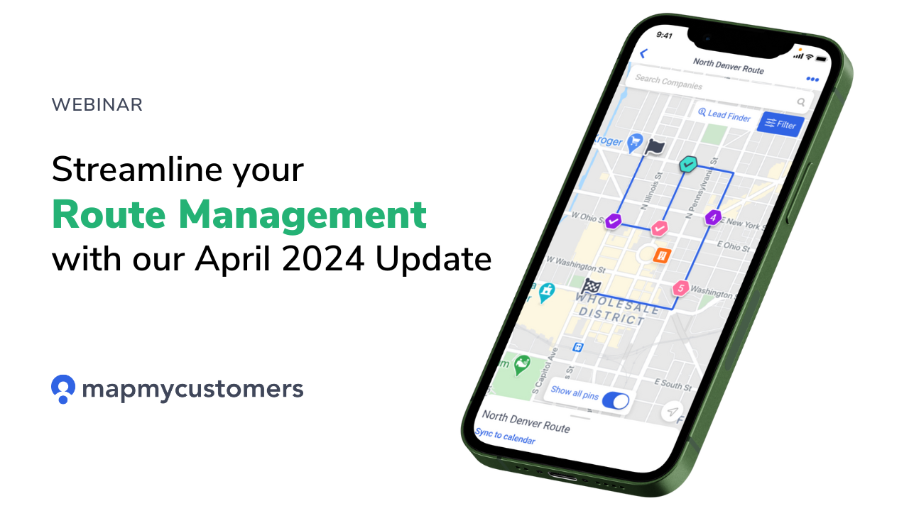
Route Planning Just Got Easier with Our Latest Update
Transforming from lone wolf sales to process-driven sales, with joe anderson, ep #17, what crm customer support should look like, ep #16, how jasper engines and transmissions built a measurable sales process from the ground up, ep #15, process beats people, ep #14, how a crawl, walk, run approach leads to a successful crm rollout, ep #13, want to transform your field sales.
Android Police
10 best navigation and map apps on android 2024.
Set off with these handy navigation and map apps
While the Play Store has superb video calling apps for connecting people, mobile devices are also perfect for personal navigation for those rare connections in person that take some quality GPS navigation to sort out. Travelers have benefited from portable devices that provide directions through an assortment of the best apps for years, so we assembled a roundup of the best map and navigation applications on the Play Store, all so you can travel with ease. So if you're looking to take control of your traveling habits with your favorite Android phone , you've come to the right place.
1 Waze Navigation & Live Traffic
A good option for a simple GPS app, Waze Navigation & Live Traffic provides everything you need for a Google Maps substitute, with sufficient quality to serve as a viable alternative. The feature list is short and sweet for this app. Traffic reports and smart route planning keep your journeys as short as possible, with a customizable GPS function sporting a variety of voice options. One noteworthy feature is streaming music and podcasts through the app to reduce instances of your GPS interrupting what you're listening to while driving. Minor issues like the interface being a little cluttered and the ETA predictions being unreliable don't serve to ruin the experience. Waze Navigation & Live Traffic is definitely worth a try.
2 OsmAnd — Maps & GPS Offline
A versatile little app, OsmAnd — Maps & GPS Offline offers an offline GPS service for many different vehicles and on-foot navigation. You can apply filters to the provided maps for different kinds of locations, from convenience stores to local attractions. You can also switch the type of map to represent different terrain, a useful feature for foot hikes and cycling trips. OsmAnd — Maps & GPS Offline contains a GPS service with an impressive amount of customization options to play around with. Ultimately, this app is better suited to off-the-road exhibitions and adventures rather than vehicle journeys. It showcases an aspect of mobile devices that can go unnoticed by some, the ability to electronically store a database of traditional fixed maps. If you like that idea, OsmAnd — Maps & GPS Offline works a treat.
3 Sygic GPS Navigation & Maps
If you're looking for a reliable app for getting from point A to point B, You could do worse than Sygic GPS Navigation & Maps. Boasting regularly-updated maps of every country in the world that can be accessed offline, the app offers a quality service for those looking to travel abroad. Sygic GPS Navigation & Maps provides a live GPS feature, along with a whole host of safety features. The app does have some issues with traffic rerouting and occasionally requiring internet connectivity when it shouldn't have to. Despite this, Sygic GPS Navigation & Maps provides a decent service for both on and off-the-road travel, with an adequate feature list to keep you on the road with confidence.
4 Circuit Route Planner
An excellent tool for couriers, Circuit Route Planner provides a decent feature list for getting your packages out on time. Utilize the best of existing GPS apps like Google Maps and Waze to keep your journeys swift and succinct. You can also take stock of where a particular delivery item is in your vehicle, saving you time at the delivery location. Features for locating the most optimal route concerning traffic and vehicle size are included but can be faulty and incorrect, although other features endeavor to compensate. A slew of included features allows you to schedule your deliveries, including ETA between delivery stops and for the delivery job overall. Courier work is extremely important, so a keen sense of direction and talent for time management skills are in high demand.
5 Petal Maps – GPS & Navigation
A solid and versatile application, Petal Maps – GPS & Navigation provides a variety of features that give you 360-degree awareness of what's around you. The app plans out the best route to your requested location, taking traffic congestion into account while guiding you. Institutions on the way to your destination are all taken into account by Petal Maps, allowing you to customize which places for the app to point out. It's also useful for cycling and public transport, having modes designated for each. Information can also be shared with other users of the app while on the road, a unique feature for a travel app. The option to download maps for use offline also caters to hikers, cyclists, and those stranded. There's barely anything to dislike about this app, so it's recommended, especially if you want something a bit more unique for exploring.
6 GO Navigation – GPS Sat Nav
Another simple one, GO Navigation doesn't reinvent the wheel but delivers exactly what's promised. Features include alerts for traffic, road accidents, and speed cameras, in addition to the cheapest source of fuel along the way. The route planner updates in real-time to keep track of any road hazards or delays in your path, though there are some reported issues with the app losing the user during journeys, requiring a reset. This will affect some users more than others, but it's fairly inconsistent and can be ignored for the most part. GO Navigation also supports truck journeys, including features that track gas stations along your route and can alter your path if any of the cargo in your vehicle is dangerous. This makes GO Navigation – GPS Sat Nav a fairly good choice for both casual and professional travel.
7 AllTrails: Hike, Bike & Run
Let's slow down a bit and talk about an app for more active means of travel. AllTrails: Hike, Bike & Run caters specifically to hikers and cyclists, boasting features that provide thousands of locations perfect for outdoorsy people. The app even advertises famous hiking and cycling routes in your area, whether they're dog-friendly, child-safe, or wheelchair accessible. You can also filter the routes by length, customize them based on your fitness level, and track your progress along those trails as you traverse them. The interface can be slightly fiddly with some connectivity issues, but offline maps remedy this issue to a certain extent. If you don't want to fork out for a Fitbit, AllTrails is a great way to plan routes for exercise on the cheap.
MAPS.ME offers the standard trappings that you'd expect from a competently put-together navigation app, in addition to some features perfect for tourists. The app provides travel guides for specific locations around the world, ranging from rural to industrial. It also provides insight into hiking trails and other neat details that other navigation apps miss. MAPS.ME is also available in an impressive number of countries all across the globe, meaning you can start finding a place to have dinner before the plane even touches the tarmac. The app also allows you to book your stay in thousands of hotels, all within the application itself. Stability is fairly good, with some reports of minor app crashes and ambiguous directions being hardly deal breakers. A slightly more concerning issue is the app sometimes forgets what side of the road you are supposed to be driving on, although this shouldn't be a problem for seasoned drivers. Check out if you're planning a holiday and want an eye on the inside.
9 Multi-Stop Route Planner
An app designed with delivery companies in mind, Multi-Stop Route Planner provides tools for optimizing routes and keeping clients informed. Similarly to popular Android package tracking apps, users enjoy an intuitive interface to check delivery times, insert their own marked locations, receive real-time traffic updates, and send clients updates while on the go. Multi-Stop Route Planner makes deliveries simpler, going above and beyond to make the process quick, efficient, and accurate.
10 Komoot: Bike GPS & Hike Trails
Komoot: Bike GPS & Hike Trails gives you the freedom to enjoy outside activities worry-free with features to ensure things stay on track. Get non-intrusive directions while hiking, cycling, or running, and enjoy offline maps to feel at ease about data usage. Komoot: Bike GPS & Hike Trails has a community aspect, encouraging users to add their experiences to a social hub for others to enjoy. If you like sharing tips and tricks with other outdoor enthusiasts while being safe on the go, this is what you're looking for.
Packed your bags for your next trip, and don't forget these handy navigation apps
Like the best wireless headphones , navigation apps exist to make your travels more enjoyable, with the added benefit of keeping you safe and on track. Feel free to rest up, pack your favorite electronics for travel , and keep your eyes on the road while the Play Store does the rest.
Top Streets and Trips Alternatives for Routing
Updated on January 15, 2024 by Jennifer Collins

In the fast-moving world of delivery, planning your route well is essential. It's like a map that helps trucks find the best way through lots of streets to save time and money on fuel. Microsoft Streets and Trips used to be great for this job, but as things change, we get new tools, too.
Now, we have even better software options because they're easy to use and update in real time. These excellent new tools help companies make their deliveries smoother. They also cut costs and keep customers happy.
As delivery changes, businesses must use these new tools to stay on their game.
According to a report by Capterra, better delivery management software can help businesses save up to 30% on fuel costs and increase delivery efficiency by 40%.
This article will explore various alternatives to Microsoft Streets and Trips. We aim to provide valuable insights into the features and benefits that make such delivery route planning solutions as Track-POD stand out.
So, let's get started!
Limitations of legacy tools like Microsoft Streets and Trips
Legacy route planning tools, like Microsoft Streets and Trips, were useful back then. But they need help to keep up with what people expect for the delivery work of today.
When companies get bigger and have more vehicles to manage, doing things manually takes time. To work on such tasks, in comparison to various solutions available today, Microsoft Streets and Trips would have needed additional smart tech to find optimal routes. That means dispatchers who used Streets and Trips to plan deliveries were guessing instead of using data-based optimization.
There was nothing in there that adjusted for traffic conditions in real-time. It did not account for whether drivers were available or how long their stops took. That created the burden of manually managing drivers to keep the route information updated and customers informed.

Here are some other limitations of some legacy tools like Microsoft Streets and Trips:
Outdated maps
Old tools like Microsoft Streets and Trips rely on maps that aren't up to date. They show old info about roads, and do not account for live traffic information, which disturbs route planning and delivery efficiency.
Limited real-time updates
Not having the latest traffic updates means you can't adjust quickly to traffic jams or closed roads. This could make your delivery drivers late and slow down their progress through the daily tasks.
Complex user interface
These legacy tools are often complex to use, making it challenging to plan routes conveniently. The tricky user interface takes longer to learn and get things done.
Limited integration
You can't mix these legacy tools with new tech, further limiting what they can do. Delivery businesses need to use all their gadgets and software together effectively.
Inflexible route optimization
Due to technological limitations, outdated platforms, and low speeds, legacy route planning tools might not be able to find the best possible route. This may result in slower deliveries, lower performance, and unhappy customers.
Dependency on manual input
Putting in data by hand raises the chance of mistakes happening, plus it's time-consuming when planning routes – this may lead to wrong directions being followed or wasted time.
Inadequate mobile functionality
Since there's limited mobile support, delivery drivers need help accessing or changing their routes while moving around, affecting how quickly they respond during deliveries.
Limited customization
If you need unique route settings for different types of deliveries, these legacy systems may be unable to help since they're not very flexible.
It's essential to switch to a more modern route planning technology that has current updates, easy-to-use designs, and many extra options helping businesses handle deliveries better as things change.
Why seek alternatives?
Legacy tools like Microsoft Streets and Trips have limitations. These limitations highlight the need for more advanced route planning alternatives. These alternatives should be feature-rich. Last mile delivery operations require better options, and modern tools provide vital benefits that directly address the evolving needs of businesses in this space:
Increased operational efficiency
Today, route planning tools use innovative solutions and data analysis to improve delivery routes. These include live traffic news, GPS tracking, and auto re-routing - features that help save time at each stop.
These tools also work with sensors and IoT devices to improve the routes even more. They increase efficiency and help cut down costs for fuel, driver hours, and taking care of delivery vehicles.
Enhanced optimization
Today's software solutions do more than plan the fastest route; they can adjust them on the go. They use machine learning, an intelligent tech that learns from new information, such as sudden weather shifts or traffic hold-ups.
This way, they tweak paths and timings as needed while unforeseen things happen. These tools are also integrated into order management systems and keep track of stock to make better decisions based on how much needs picking up or dropping off.
By doing this, businesses get the most out of their time and give top-notch service.
Improved customer experience
People now want quick chats, speedy deliveries, and precise information. Today's tech tools are great because they focus on what customers want. They let you track your stuff in real-time with phone apps and tell you when it is likely to arrive.
Such platforms also make sure deliveries happen faster by finding the best routes. Plus, they give a clearer view of how things are going so businesses can see where to improve their service.
Exploring Track-POD, a premier alternative for delivery route planning
Track-POD is an excellent choice for planning routes , especially compared to older tools like Microsoft Streets & Trips.

Streets & Trips was good in the past for figuring out the best ways to go. However, Track-POD makes planning and sending out deliveries even better. With Track-POD, people who organize deliveries can use a simple drag-and-drop system to make smart routes quickly.
The platform looks at how long trips take, how far delivery locations are, how much stuff vehicles can load, and takes into account the requirements for some specific delivery times. It uses all this data to develop sound plans for getting deliveries where they need to go.
Key features of Track-POD include:
Optimal route algorithms
Track-POD has innovative programs that create the best delivery paths by considering real-life limits. These programs help plan better. They cut down on distance and time spent traveling to improve how deliveries are made overall.
Scalability for complex fleets
Track-POD can handle delivery fleets of any size. It stands out as a solution for businesses with hundreds of stops. Its scalability ensures that even the most complex delivery networks can be efficiently managed and optimized.
User-friendly maps and visual editing
Track-POD offers a user-friendly interface with intuitive maps and visual route editing capabilities. This feature simplifies the planning process. It allows users to make quick adjustments and fine-tune routes based on specific requirements or unforeseen circumstances.
Customizable dashboard and metrics
The platform provides a customizable dashboard for all delivery needs. It presents critical metrics and insights at a glance so that users can track and analyze relevant data. This helps them gain actionable insights into their delivery operations, leading to better decision-making.
How do Track-POD's key features drive business success?
By leveraging these capabilities, Track-POD users can achieve significant operational improvements:
Optimized operational efficiency
Track-POD utilizes powerful algorithms. This reduces mileage, lowering fuel and maintenance costs . The optimized routes enhance operational efficiency, saving both time and resources.
Increased delivery throughput
In practice, while a delivery driver is allocated almost 1-2 minutes for each delivery, the reality sees them spending 5 minutes on the manual process at each stop. This divergence acts as a roadblock to streamlining the delivery process.
The scalability of Track-POD addresses this challenge, empowering businesses to handle more stops per route. This increased efficiency results in more daily deliveries. It is pivotal for companies trying to maximize delivery throughput.
Enhanced asset utilization
Track-POD helps businesses use their vehicles and plan better. By utilizing their assets well, companies can ensure they use everything as much as possible. This cuts down on wasted time and gets more work done.
Improved customer service
50% of businesses need help to meet same-day delivery commitments, grappling with inefficiencies in their delivery processes and the heightened pressure on drivers. Addressing this challenge becomes crucial. Giving customers the right delivery times and tracking their orders improves customer service.
They get quick updates, which builds trust and shows we're reliable. This is key to keeping good relationships with our customers.
Driver satisfaction and efficiency
Fair and achievable routes contribute to better driver satisfaction. Track-POD provides drivers with optimized routes. The routes consider their well-being. This helps enhance overall workforce morale and efficiency.
Comparing pros and cons of honorable alternatives for route optimization
Track-POD stands out as a leading route planning solution. Yet, businesses should be aware of other software tools. Here is a brief overview of a few alternatives:
OptimoRoute
OptimoRoute is route planning software. It optimizes business delivery routes and schedules, emphasizing time and cost savings. It targets small and medium-sized enterprises and offers scalability as businesses expand. The platform includes a mobile application, providing real-time route updates and facilitating communication between drivers and dispatchers.
- Ease of Use: OptimoRoute is praised for its user-friendly interface, making it accessible for businesses of varying sizes.
- Scalability: The software is adaptable and can scale with the organization's growth. It accommodates changing needs.
- Reliability: Users appreciate the platform's reliability. It ensures consistent performance in route planning and optimization.
- Responsive Support Team: OptimoRoute's support team is known for its responsiveness. They assist users with queries and issues effectively.
- Challenges with Multiple Routes: Planning multiple routes for drivers in the same city using only the automatic route generator can take time and effort. This is due to challenges with various routes.
- Limited Detail on Failed Deliveries: There needs to be more detail on failed deliveries. The platform cannot provide a reason or explanation when marking a delivery as failed. This limits insights into performance issues.

Routific helps companies plan the best ways for their drivers to deliver things. It looks at traffic, what the driver likes, and what's essential for the business. This tool works to make routes better so that companies can save time and use up to 40% less gas. Delivery businesses all over the world trust Routific. It makes a difference in how well their routes work.
- Ease of Use: User-friendly interface, making it accessible for businesses of all sizes.
- Intelligent Route Optimization: The software stands out for its intelligent route optimization. It avoids rush hour traffic, busy tunnels, and bridges. This enhances overall delivery efficiency.
- Real-time Route Updates: A mobile application gives drivers real-time route updates. This fosters improved communication with dispatchers.
- Responsive Customer Support: Highly responsive and helpful customer support, ensuring timely assistance for any queries or concerns.
- Limitation with Multiple Routes: Planning multiple routes simultaneously for various drivers in the same city may be challenging with Routific.
- Lack of Real-time Traffic Updates: The platform needs real-time traffic updates and messaging features, potentially affecting adaptability to changing road conditions.
- Pricing for Customer Notifications: Some users may find the pricing for customer notifications to be higher, which could impact overall cost-effectiveness.

Route4Me is delivery route planning software. It's designed to help businesses optimize their routes and streamline delivery processes. The platform focuses on creating efficient routes. It takes into account traffic conditions, driver preferences, and business priorities.
Route4Me aims to enhance productivity and reduce costs for businesses. They rely on efficient route planning.
- Route Optimization Customization: Users appreciate the ability to customize route optimization based on various factors, providing flexibility in meeting specific business requirements.
- User-Friendly Interface: Route4Me is known for its user-friendly interface, making it accessible for businesses seeking a straightforward and efficient route planning solution.
- Real-time Tracking and Monitoring: The platform offers real-time tracking features. Businesses can monitor routes as they unfold.
- Comprehensive Reporting: Route4Me provides detailed reporting and analytics. This helps businesses gain insights into route performance and identify areas for improvement.
- Pricing Complexity: Some users find Route4Me's pricing structure complex. This might create challenges in understanding and managing costs.
- Learning Curve: The interface is user-friendly. However, users new to route planning software may need some time to become fully proficient.
- Limited Free Plan Features: The free plan's features may be limited. Businesses may need to subscribe to premium plans for advanced functionalities.

Revolutionizing operations: Track-POD's impactful case studies
Businesses achieve significant efficiency gains, cost savings, and an improved user experience by leveraging Track-POD's advanced route optimization. This is in comparison to legacy tools like Microsoft Streets and Trips.
Here are some leading businesses using Track-POD to optimize their operations. They are driving success.
GAP Nationals enhances efficiency with ePOD and route optimization
GAP is a leading manufacturer and distributor of PVC-U building products. It has 40+ depots and over 240 vans across the UK. GAP Nationals supplies PVC-U building products.
GAP invested in a new electronic proof of delivery system featuring route and fleet optimization options from Track-POD to reduce the paperwork and improve customer services from Aberdeen to Wickford in the UK
Track-POD's ePOD system and routing software helped GAP reduce the time spent on field staff administration by 60%.
The software also helped GAP improve its customer service. It provided real-time delivery updates. It reduced the time spent on manual data entry.
Girteka Logistics boosts delivery rates with TrackPod
Girteka Logistics' 3PL segment was looking to improve on-time delivery and customer service. They also wanted to engage third-party carriers. They came to Track-POD to get real-time PODs with order tracking for their customers.
Track-POD's ePOD system helped Girteka improve its customer satisfaction and reduce the time spent on manual data entry. The software also helped Girteka achieve delivery in full and on time. It also records proof of delivery with a digital signature. It includes a map feature to help them track, plan, and optimize routes. Additionally, it sends the daily run sheet to drivers and 3rd party carriers via a mobile application.
As a result, Girteka achieved a 99% delivery in total rate. They achieved a 97% on-time delivery rate . Also, 95% of jobs are now dispatched electronically. Staffing productivity increased by 60-70% , and customer calls decreased by 80% due to the tracking feature.

Elevate operations with Track-POD: A modern solution for route planning excellence
Upgrading your route planning tool is essential to improve your delivery business. Traditional tools like Microsoft Streets and Trips can't cut it anymore. They lack planning routes, tracking features, and giving you updates as things happen. This all leads to extra costs and big headaches.
If you switch to something newer like Track-POD, you'll see a bunch of perks. It plans routes intelligently, keeps tabs on drivers, manages deliveries smoothly, and even helps with reports that tell you how your business is doing. Plus, it's easy to use with lots of tools but won't break the bank.
With Track-POD's techy platform, growing your delivery service becomes much more accessible. So, if saving money sounds good, making sure drivers do more work in less time, or giving customers an excellent delivery experience, putting Track-POD into action (or another up-to-date system) is the move for your business!
Request a Demo
About The Author

Jennifer Collins
A seasoned content writer with a passion for unraveling the intricate world of logistics through words.
Popular Posts

The ONLY Free Shipping Label Template You'll Ever Need September 20, 2023

ALL NEW Customer Notifications [Track-POD Web 2.0] October 04, 2023

Advanced Routing 2.0: Discover Plan & Track, Cut Route Planning Time in Half June 26, 2023
#1 all in one delivery management software.

Route Optimization and Planning
Why optimoroute is the best replacement for microsoft streets & trips.
September 2, 2022 7 min read

You’ve probably suffered the disappointment of your favorite store or restaurant closing down at some point. Maybe it was your favorite place to shop for your clothes or the best place to pick up food with your friends before the big game. Once they closed down, it wasn’t so easy to just switch to another shop or restaurant you liked. You had to find a replacement for a key part of your regular routine, one that had become almost second nature.
Many delivery teams were left in the same position when Microsoft discontinued Streets & Trips in 2014. They needed alternative options for route mapping software to find and plan the fastest routes for their drivers.
If this situation sounds familiar, and you’re still looking for the best Microsoft Streets & Trips replacement, we’ve got you covered. OptimoRoute’s software can help you achieve even better route planning than Streets & Tips, with real-time tracking, workload balancing, and automatic route optimization based on your business needs.
Jump ahead to the section that most interests you:
What Was Microsoft Streets & Trips?
- Is Microsoft Streets & Trips Still Available?
How Streets & Trips Worked
Who used streets & trips.
- 5 Features That Make OptimoRoute The Best Microsoft Streets & Trips Alternative
Microsoft Streets & Trips FAQ
Microsoft Streets & Trips was a computer program that could map out multi-stop routes between businesses, stores, restaurants, and other places of interest. The program was originally developed by NextBase Limited , a UK-based company, in 1989 and was known as AutoRoute. Microsoft bought NextBase and the AutoRoute program in 1994, so they could continue developing the software. Eventually, it was rebranded as Streets & Trips in 2000. Unlike MapQuest , which launched in 1996 as a web mapping service, Streets & Trips was developed for offline use.
Microsoft released updates and new versions annually, continuing to update the maps and capabilities of Streets & Trips. Eventually, the program contained more than six million miles of maps for users to navigate with. Whether it was a family road trip or an easier commute to the office, they could plan out the best route to take using the software.
From its earliest versions, Microsoft Streets & Trips provided features like door-to-door directions, points of interest along routes, and surveys for restaurant reviews. By the time it was last updated, Streets & Trips had grown into an even more customizable, user-friendly tool for planning optimized routes between multiple stops.
Is Microsoft Streets & Trips Still Available?
No — Microsoft discontinued Streets & Trips in 2014, along with its broader category of Microsoft MapPoint technology, and stopped supporting Streets & Trips in 2015. They discontinued the tool in favor of Bing Maps, Microsoft’s online web mapping service. The move reflected a larger shift toward online mapping and navigational tools rather than an offline route planner.
Streets & Trips hasn’t been updated since 2015, and plenty of new roads and highways have been built since then. In the U.S. alone, about $565.55 billion was spent on new highway and street construction between 2015 and 2020. The maps available on Streets & Trips won’t be accurate to what you’d find in the real world anymore and may not get you to your destination. Delivery team members looking for up-to-date software must explore alternative route management and optimization options instead.
Streets & Trips was developed as an offline mapping tool for “ point-to-point navigation .” It was primarily used on a computer or laptop to map out the best route between two or more locations, but later versions included added functionality as well.
Some of Streets & Trips’ most helpful features included:
- GPS with voice-prompted directions: Microsoft introduced this feature in the 2006 version , giving drivers hands-free, turn-by-turn directions.
- Automatic rerouting: Introduced in 2008 , Streets & Trips could catch when drivers made a wrong turn and direct them back toward their destination.
- Traffic updates: Drivers were given updates on traffic flow, construction, and other incidents for more efficient route planning. This was also released in the 2008 version .
- Pushpins: Users could pin locations or points of interest to their maps to personalize routes and directions. In the 2013 version , they had the option of turning pushpin names on or off for easier trip planning.
- Online ratings and reviews: One of the features that made for a more tailored trip planning experience, Microsoft introduced more robust review capabilities in 2013 .
Although certain features integrated with MSN Direct and Live Search Maps, Streets & Trips was primarily an offline tool. Users could access information like traffic and weather updates or directions to the nearest gas station without being connected to the internet. But they couldn’t receive true, real-time updates because of the software’s offline nature. Businesses trying to track deliveries or make adjustments to drivers’ routes were limited in what they could do.
Because of its accessible price point, both consumers and businesses used Streets & Trips as a navigation solution. Commuters used it to avoid traffic on their way to work, and families would plan long road trips, plotting out ATMs, hotels, gas stations, and points of interest in advance. On the business side, both delivery teams and sales teams used Streets & Trips to plan their routes to customers. Field sales reps used it for territory mapping and planning out sales routes when visiting new customers. Delivery companies would plan the fastest routes to drop off their packages.
5 Features That Make OptimoRoute the Best Microsoft Streets & Trips Alternative
If you’re looking for efficient route optimization software to replace Microsoft Streets & Trips, OptimoRoute is the answer. Don’t rely on Google Maps to create routes for you. Our software easily maps out the fastest multi-stop routes for your delivery drivers while reducing time on the road, so you can make more deliveries and improve fuel efficiency.
Automatic route planning & optimization
You can balance priority scheduling, driver overtime, and delivery windows—all without any manual calculations. You no longer need to spend hours factoring in schedules, workloads, customer preferences, traffic, and timing. Instead, you can plan out routes for your delivery drivers incorporating all of those factors in just a few seconds.
With automated route planning , you’ll go beyond the basic navigation and plotting of Streets & Trips to truly optimize your full driver fleet. Produce delivery schedules weeks in advance so you can better manage your workforce and your vehicle fleet. Our software will even suggest the best days and times for running certain delivery routes, automatically scheduling them for the fastest windows based on traffic patterns. And with location-based route planning, you can assign drivers to geographic zones for even greater efficiency.
Real-time order tracking
Send your customers real-time status updates , tracking links, and delivery notifications for a seamless customer experience. You’ll improve customer satisfaction and reduce frustration by keeping them well-informed about when their package will arrive.
Real-time order tracking and live updates are already integrated into our tool. Customize your text updates using our template, and choose which information you want to include, like order ID and estimated time of arrival (ETA). They’ll receive a live tracking link, where they’ll be able to see updates and a countdown to their arrival time, so they know exactly when to expect their package.
ETA updates
Gain visibility into where your drivers are on the road and when they’re expected to complete deliveries so you can monitor for roadblocks and re-plan routes as needed.
ETAs are key to understanding and optimizing delivery routes, as well as providing accurate real-time updates to customers. If there are route delays or drivers fall behind schedule, you’ll need to re-plan so you can still get all your deliveries out. OptimoRoute gives you real-time visibility into driver location and ETA so you can adjust on the fly and keep your customers happy.
Proof of delivery & customer feedback
Collect proof of delivery and automatically request customer feedback to ensure your customers are getting the best experience possible. Our software allows drivers to easily collect customer signatures as well as photos and notes on who accepted the delivery. With strong documentation, you can respond quickly if customers call with any delivery issues after the fact.
Send out invites for customer feedback through email or text so you can gain fresh insight into your company’s reputation. Personalize survey questions or ask customers to leave comments and ratings. Then, view feedback and driver ratings through OptimoRoute’s analytics dashboard so you can uncover areas where your customer experience shines and where there’s room to improve.
Balance your drivers’ workloads to reduce costs, and allocate tasks based on driver skillsets to get the most efficiency out of your route planning. Plan routes based on either the minimum drivers needed or distribute deliveries evenly among them. Our route planning tool can also automatically balance by working hours or number of orders per driver to reduce strain on drivers while lowering payroll costs.
Workload balancing
You can also plan delivery routes or tasks based on drivers’ skillsets. Automatically assign delivery tasks to drivers with the skills to handle them, such as assembling furniture, for the most efficient workload management. The tool’s flexible scheduling will automatically adjust route assignments and start times based on working hours, callouts, labor costs, and miles driven.
Looking for a better alternative to your route optimization software? OptimoRoute can help you scale quickly while cutting down on delivery times and optimizing workloads for every driver. Learn about how one restaurant plans 500 deliveries in just five minutes. Or sign up for a free, 30-day trial to see how OptimoRoute can help improve routing for your business!
What happened to Microsoft Streets & Trips?
Microsoft discontinued Streets & Trips in 2014 after they made the switch to Bing Maps. The software hasn’t been updated since 2015. If you’re still using Streets & Trips to plan your routes, you’re using outdated maps and navigational info, and you have no access to real-time traffic updates.
What will replace Microsoft Streets & Trips?
Customers will need to replace Microsoft Streets & Tips with other route mapping or navigation software. For consumers looking for basic navigation or GPS, tools like Waze or Google Maps can do the trick. But for businesses, they need something more robust and efficient for route planning.
Is OptimoRoute an alternative to Microsoft Streets & Trips?
OptimoRoute is the best alternative to Streets & Trips. The automated route planning and optimization are even more valuable than the basic navigational features offered in Streets & Trips. Delivery planners can gain access to efficient routes, driver scheduling, and real-time tracking in just a few seconds instead of spending hours combing over the best paths for their drivers.
Try OptimoRoute ™ for Free
No installation or credit card required
Main categories

Make Your Mobile Workforce 43% More Productive. Optimize Driver Routes in Just 7 Minutes.
Start A Free Trial Now
No Credit Card Required
Microsoft Streets and Trips Alternative
Back in 2014, Microsoft discontinued Streets and Trips. While there are plenty of other map and GPS applications available, few include the robust route planning capabilities of this platform. Many people are still looking for a replacement to this day.
So, what happened to Streets and Trips and what alternatives are available? We’ll go over the history of this software and fill you in on the best replacement for Microsoft Streets and Trips.

What Was Microsoft Streets and Trips?
In 1988, Nextbase released a mapping and routing program called Autoroute. It became extremely popular, so much so that in 1994 Microsoft bought the product in order to incorporate the technology into their own tools.
Streets and Trips 2000 was a combination of Autoroute and Microsoft’s Expedia Trip Planner, and the result was a new and more advanced mapping platform. From then on, the software became a Microsoft staple and the company released several updates and improvements all the way up until 2013.

What Happened to Microsoft Streets and Trips?
In July of 2014, Microsoft announced that it was discontinuing Streets and Trips. In their statement, the company recommended users switch to Microsoft’s other mapping solution, Bing Maps.
The problem with this is that Bing Maps lacks many of the features offered by Streets and Trips. It’s not designed for sales and lead generation. Rather, it’s a consumer product intended for people travelling to only one location.
As a result, sales teams were left without an equivalent mapping solution.
How Can Maptive Replace Microsoft Streets and Trips?
With a host of advanced mapping features, Maptive helps gives businesses the tools they need to manage their sales and leads effectively.

Advanced Route Optimization
Quickly find the quickest route between two or more locations. Use the route planner to plot multiple trips at once to improve efficiency.

Data Visualization and Filtering
Upload your location data to Maptive and plot it on an interactive map in seconds. Use the filter tool to decide what to display and what to hide.

Cloud-Based Solution
The platform is entirely cloud-based , meaning it’s accessible from anywhere and on any mobile device, including tablets and smartphones. Easily make changes to your maps while you’re on the road or out of the office.
Up to Date Maps
Maps are updated frequently to ensure you always have the most current information.
Export and Print Directions
Export your data to a CSV file or print your map directions and take them with you.

Global Maps
Maptive has maps for every country , so no matter where you are you can find the quickest route.
What Other Tools Does Maptive Have?
In addition to providing all the features that Streets and Trips did, Maptive also offers several other valuable tools:
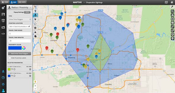
Drive Time Polygons
Enter a starting location and a drive time to see how far you can travel in any direction. The drive time polygon tool is ideal for establishing service areas and assigning leads to salespeople.

Territory Tool
Create sales territories based on established boundaries, such as zip codes, counties, or states. Or use the drawing tool to create custom territories. Track sales and performance for each region to ensure they’re meeting their goals.

Density mapping
Build powerful heat maps to show where markers or data such as sales are concentrated in a given area using the density mapping tool . Get insights into your customer sales data.

Demographic Data Mapping
Map out built-in demographic data onto your maps to glean new market insights from your target markets.
Replace Microsoft Streets and Trips with Maptive Today!
Maptive offers everything you need to plan routes and optimize your sales, and does it even better than Streets and Trips did. Sign up for a free trial account and start mapping today!
Start Your Free, No Risk, 10 Day Trial
No credit card required. No surprises. Just Results.
Privacy Overview
The 11 Best Google Maps Alternatives For Android In 2022

Google Maps is widely regarded as one of the best, most reliable navigation apps for both Android and iOS devices. But the app isn't for everyone. Whether you have particular needs in a navigation app that Google Maps just isn't meeting, or you simply don't want an app made by Google, there are a ton of great alternatives. (If you don't want an app owned by Google, you should avoid Waze, as well.)
There's never going to be a perfect navigation app for everyone, because people have different needs. If you drive your own car to work every day, the best app for you is going to be different than the best app for someone who frequently goes on long-distance road trips where they don't have service, or someone who uses public transit to get around. Many of the navigation apps on this list have similar features with unique user interfaces and customizations, but there are some that are wildly different and focus on one or two modes of transportation.
Whatever you need, one of these apps is bound to be perfect for you.
Though Google Maps and Waze are both wonderful apps for navigating the roads of your city, there's one big difference between the two. Google Maps collects a ton of information via satellites and actual people driving around town with a camera setup on their cars. Alternatively, Waze relies heavily on crowd-sourcing, using everyday drivers to provide the app with info on traffic, accidents, speed traps, and more.
With over 140 million Wazers, you can expect the info you come across in the app to be accurate. And if it's not? Well, you're able to state in real-time that an accident is no longer there, or that you've run into a new road closure. If you're in a highly populated area, this is great for getting to work well before you need to clock in. But if you're going on a road trip where other Wazers might not be present, you won't have as much insight.
If you're familiar with Google Maps, you've likely experienced the app asking you whether you want to change your route if a quicker option becomes available. The Waze driving experience is dedicated to getting you to your destination as fast as possible, and won't ask you if you want to switch routes; it'll just do it. It's also worth mentioning that Waze isn't the best option for you if you rely on public transportation, walking, or cycling. Instead, the app is targeted toward people driving personal vehicles or motorcycles.
All that said, Google acquired Waze in 2013, so both Google Maps and Waze are now owned by Alphabet, Google's parent company.
Download: Waze ( Android ), ( iOS )
If you lived before smartphones and Google Maps changed the navigation game , you're probably familiar with a company called MapQuest. It was a common task before road trips to print off directions from MapQuest, because that was the only way to take navigation on the go with you. Of course, there were also physical road maps to reference, but printed MapQuest directions were such an innovative idea around the early 2000s.
Unlike Blockbuster in the Netflix era, MapQuest adapted, and is now a worthy competitor to Google Maps. Much like Google Maps, MapQuest is rich in features and customizable to your unique preferences. While you can't get info for public transit or cycling, you can see routes for both driving and walking.
You can choose to show traffic slowdowns or incidents to better understand your route estimate. Then, there are also a ton of layers you can enable based on what you want to see at that time, including Food, Gas, Hotels, Shopping, and Coffee. You can enable as many of these layers as you want; if you enable too many, however, it might clutter up your view.
Download: MapQuest ( Android ), ( iOS )
All the information you see in Google Maps is owned by Google, whether that's info Google sought out or was given by the public community. Other apps, like MAPS.ME, rely on OpenStreetMap (OSM) for information. OSM is a collaborative project created by the community, for the community, for use around the entire world. You could even download the entire world map for offline use if you wanted.
When you first download the app, you'll see measurements in kilometers instead of miles. So if you're in the United States, you'll want to change this to miles in the app's settings as soon as possible. That is, unless you like using the metric system.
As long as you give the app location permission when you first set it up, it'll automatically download an offline map of your local area. With the app's handy toggle in the top right corner, you can easily see if you're online or offline while using the app.
Because this app has information from tons of users, it's very detailed. Individual street names show up even if they're tiny streets, water stands out as blue, park areas stand out as green, and important landmarks are noted, like gas stations, pharmacies, grocery stores, and restaurants. You can also add a Terrain or Subway layer on top of the traditional map.
Download: Maps.Me ( Android ), ( iOS )
Like the MAPS.ME app, OsmAnd also relies on OpenStreetMap (OSM) for its community-based geographical information. In addition to OSM, the app has another open-source project built in. OsmAnd also makes use of Wikipedia POIs, or Points of Interest, to help its users find the most exciting things to do while traveling to a new city, or simply exploring their local area.
When you first open up OsmAnd, the app will predict your location and let you download the local map for use offline. Then, even if you find yourself in an area with no internet service, you'll be set. The app is colorful and feature-rich. You can switch between the American road atlas and others, customize map details, text size, or language, and see routes for cycling, hiking, and running. However, the most notable feature involves Wikipedia's POI overlays, which include restaurants, emergency places, gas stations, parking, sightseeing, and more.
Download: OsmAnd ( Android ), ( iOS )
Google Maps shows public transit routes and time estimates for local buses and other vehicles, but it's not dedicated to this group of commuters. For the most part, Google Maps is marketed toward those who drive their own vehicles, because that's the majority of its users. Citymapper is an alternative to Google Maps that'll show you the best way to get around town without your own vehicle.
After you enable your location, Citymapper shows you a map of your local rail system, if you have one in place. For example, the Dallas metroplex has the DART Rail. This way, you can see how all the tracks intersect, and know exactly which rail you need to hop on.
If you map yourself somewhere specific, CityMapper shows you estimates for walking and biking, as well as the estimated calories you'll burn, and options for local cabs or rideshares near you. But for the most part, Citymapper shines when it comes to picking the best public transit route from all available buses, trams, and rails.
Download: Citymapper ( Android ), ( iOS )
Sygic GPS Navigation
Sygic GPS Navigation is yet another app that relies on offline maps to help you get around town. By doing so, the app ensures you can navigate your local area even if you have no service. This is incredibly helpful if you're in a mountainous area where you might frequently lose signal.
The app gets its data from TomTom Traffic, which is sometimes what you'll see in use for car navigation systems. It has useful features like turn-by-turn navigation, speed limit notifications, voice-guided directions, and wrong-way warnings, which can detect you driving the wrong way, or warn you of another wrong-way driver on the road.
If you've got an extra $19.99 per year to spare, there's a Premium+ subscription within Sygic that comes with quite a few handy features. One of the coolest Premium+ features is Real View Navigation, which uses AR, or augmented reality, to display the map over your actual surroundings, as long as your phone is propped up on the dash and your camera is pointed toward the road.
Download: Sygic GPS Navigation ( Android ), ( iOS )
The Scout app is more social than any other option on this list. You can quickly send out real-time driving updates to friends with your location and estimated time of arrival, or ETA. Many other navigation apps can do this, too, but they can't send out automated alerts to your loved ones when you arrive and leave set locations. No more worrying about texting your mom when you've made it to your destination on a road trip, because Scout will do it for you!
Scout also provides easy shortcuts for your daily commutes, favorite places in your area, and chats among friends and family. If enough of your friends and family download Scout as well, you can discover commonly-liked locations among your group, and share the best restaurants or bars you come across on the Foodie tab.
Similar to how Google Maps shows business information , the Scout app shows you extra information about certain retail locations, like their open to close hours, complete address, phone number, and the ability to easily share or favorite the location. Then, the actual navigation experience is like most other navigation apps. You can turn off the voice-activated commands and view the entire route while you're currently in drive mode on your way to a destination.
Download: Scout ( Android ), ( iOS )
When you first start up MapFactor Navigator, you'll be prompted to customize your profile based on where you are in the world and what you drive. You can choose between Metric, Imperial (British), and American for the unit system. Then, there's a unique vehicle profile for quite a few modes of transportation, including Bicycle, Bus, Car, Motorcycle, Motorhome, Pedestrian, and Truck.
From there, you have the option to navigate around town with free maps powered by OpenStreetMaps (OSM) contributors. Or, you can pay for professional maps crafted by TomTom, the company that powers a lot of car navigation systems. Because OSM is a wonderful open-source project, most people will likely gravitate toward this free option.
For larger countries, like Canada or the United States, you can download smaller maps by subregion. If you have a modern smartphone with plenty of storage, the map for the entire United States doesn't take up much room at 3.3GB. Download all the maps you want over Wi-Fi, and you're good to go offline when you're out of the house.
Download: MapFactor ( Android ), ( iOS )
Polaris combines data from all the best sources, including Google Maps, OpenStreetMap, MapQuest Maps, and Cycle Route Maps. With all this info, you're bound to get the fastest route possible and be aware of any and all traffic incidents you might run into.
While you could use Polaris to navigate through your city or on a road trip, it's most useful for outdoorsy types who frequently find themselves on trails for snowmobiles, ATVs, or other off-road vehicles. The app even has a Garage feature where you can add certain vehicles and easily see the fuel level, maintenance reminders, and enable some remote features. Unfortunately, only certain off-road vehicles are compatible with the RIDE COMMAND+ Plug-In, or have RIDE COMMAND+ pre-installed.
If you often hit the trails with a group of friends or family, Polaris makes it easy to keep track of everyone. So even if you run into bad weather and someone has to stop away from the group for safety, it'll be easy to reconnect once the weather settles.
Download: Polaris ( Android ), ( iOS )
Avenza Maps
Avenza Maps is the best navigation app for offline maps, no matter how you plan to use them. Though you can import your own maps via Dropbox, another cloud storage app, or the web, Avenza Maps also has maps you can download from within the app. Some of these maps are free, and many of the paid maps only cost $0.99.
There are so many ways to find the perfect map in Avenza Maps. You can browse by activity if you want to find a topographical map specific to your needs, like hiking, backroading, hunting, camping, fishing, snowmobiling, and more. Or, you can search through broad categories to find what you're looking for, including Parks & Forests, Trails, Tourist, Hunting & Fishing, Roads, Nautical, Educational, Historical, and so on.
If you're just looking for maps in your local area, you can explore by your location. While many of the everyday maps you need for daily commutes and local navigation are free, there are also a ton of interesting historical and educational maps to look at in your area.
Download: Avenza Maps ( Android ), ( iOS )
If you hate navigating new locations, Petal Maps is the app for you. One of its most notable features is lane guidance for complex intersections, which includes giving you an aerial view of what the lane situation looks like, and highlights the lane you need to be in. Never again will you have to cross five lanes of traffic at the last minute because you had no idea where you were supposed to be.
For people getting around on foot with Petal Maps, the app has built-in AR navigation that makes the experience easier and more immersive. And no matter how you're traveling to your destination, you can check out the route options in advance and figure out which way works best for you before you even leave the house.
Petal Maps is otherwise very similar to Google Maps, with support for multiple modes of transportation, and a user interface that's easy to use. You'll get real-time traffic updates and can even report incidents yourself if you come across them. Plus, if you sign up for an account within Petal Maps, you can partake in the community and earn points and medals.
Download: Petal Maps ( Android ), ( iOS )
- Tech Gift Ideas for Mom
- Hot Tech Deals at Target Right Now
The 7 Best Google Maps Alternatives of 2024
Find your way around with these great apps
:max_bytes(150000):strip_icc():format(webp)/KaylaDube-d1b0fdb0e7704d5697568c25cda4350b-d6299b7e4de84ddea274b57b2124ba5e.jpeg "android app like streets and trips")
- J. Everette Light Career Center
:max_bytes(150000):strip_icc():format(webp)/ryanperiansquare-de5f69cde760457facb17deac949263e-180a645bf10845498a859fbbcda36d46.jpg "android app like streets and trips")
- Western Governors University
- Android Auto
- Apple CarPlay
Navigation apps have become essential on everybody's smartphone, and Google Maps is among the most popular. However, there are many more navigation apps to choose from if you feel Google Maps isn't working.
Here are some of the best apps for GPS and navigation available.
Best Community-Driven Navigation App: Waze
Community-oriented.
See amenities around you.
Real-time traffic data.
Hazards may not be accurate.
Little advantage in areas with few users.
Drains battery in background.
Waze is a unique GPS navigation app focusing on the social aspect of driving with others. You can see other Waze users on the map, and users can report hazards so that you can get alerts for them on your drive.
The app is also highly customizable, allowing you to add your home/work address, change your car icon for others to see, and save your favorite places. Waze makes driving an enjoyable experience.
Download For:
Time Tested and Reliable: Mapquest
Easy to find amenities.
Turn traffic alerts on or off.
Ability to change the map style.
Can be a little slow.
No public transit directions.
No photos option.
Mapquest is a very easy-to-use navigation app where you enter your destination and go. In addition, you can customize the map as you wish to show amenities, traffic hazards, and more.
Mapquest is an excellent option if you want an app that can be tailored to your needs, whether you want it to show you everything along your way or just the bare-bones directions.
Save Maps for Offline Use: Sygic GPS Navigation & Maps
Download maps to use offline.
Feature-rich.
3D maps available.
Premium membership required for many features.
POI icons detract from map view.
No voice controls.
If you like to have most of your maps saved offline, Sygic is a great app. It allows you to search for offline maps and download them to your phone, so you don't have to worry if you get stuck without service. You can also use offline maps whether or not you have a Premium membership.
Another great feature Sygic has is 3D real-view maps, so it's much easier to understand where you are and where you need to go.
Best Navigation App for Large Vehicles: CoPilot GPS Navigation
Routes can be optimized for different vehicles.
Maps can be downloaded and used offline.
Real-time traffic updates.
Lengthy setup.
Navigation errors.
POI search somewhat lacking.
If you use navigational tools while driving larger vehicles, like RVs or trucks, you may notice that the routes most apps give you aren't the best for your situation. CoPilot fixes this issue, giving you the best routes no matter what kind of vehicle you drive.
You can also download your maps to use offline whenever you need to, and you can plan your trips by adding multiple stops to your destination. These features make CoPilot especially great for long road trips.
Best Public Transit Navigation App: Citymapper
Provides info for many major cities.
Updates with issues in local public transportation.
Shows easiest route.
Some cities unavailable.
Routes not based on current conditions.
Doesn't provide nearby restaurants.
Are you in a large city where you rarely use a car? Citymapper is an excellent alternative to Google Maps for getting more information on public transportation.
You can search for the location you want to go to within the city, and the app will give you all your options for getting there and show you how much time each option might take. Citymapper is a great, efficient app if you live in the city and need a navigational app tailored to this experience.
Best Offline Navigation App: Maps.me
Create routes with multiple destinations.
Offline navigation available.
Topographic and subway map layers.
Navigational alerts can be slow.
No display of speed limit.
Doesn't distinguish between fastest, efficient or shortest route.
Maps.me is a great option for those who don't want to use data or Wi-Fi for navigation. All the maps the app uses are offline, so you don't have to worry about getting errors while trying to find your way.
If you want to plan a route, you can do so by entering your destinations, and then the app will show you what route to take to visit them all efficiently. Maps.me also makes a point of showing POI (points of interest) within the maps so you can discover new places you may not have found otherwise.
Best Navigation App for Hiking, Biking, Boating, and More: Pocket Earth
Highly customizable.
Offline and off-road maps available.
Detailed trips and map plotting.
Learning curve.
Not available for Android.
Limited support.
Pocket Earth has tons of maps you can download and use with GPS navigation. The app has hiking, boating, and cycling maps you can use. It's an excellent app for navigation, no matter where or what you're doing.
You can also plan trips by entering multiple destinations, adding a name, and saving the route for later. Pocket Earth is helpful if you want to plan travel in advance or if you also want to use off-road maps.
There are several ways to plan an alternate route in Google Maps . One way is to open the Google Maps app and search for a destination, select Directions > Driving > More > Route Options and choose any options you want, such as Avoid highways. Tap Done to apply the changes and select a route.
You can change the voice in the Google Maps app . Go to Menu > Settings > Navigation Settings > Voice Selection and choose an option from Suggested Voices or All Voices .
Get the Latest Tech News Delivered Every Day
- The 7 Best Traffic Apps of 2024
- The 9 Best Travel Planner Apps of 2024
- The 5 Best GPS Apps for iPhone of 2024
- The 13 Best Android Auto Apps of 2024
- The 9 Best Travel Apps for 2024
- The 9 Best Summer Apps of 2024
- The 10 Best Road Trip Planner Apps for 2024
- The 5 Best Motorcycle Apps of 2024
- The 20 Best Free iPhone Apps of 2024
- Waze vs. Google Maps: What's the Difference?
- The 6 Best Compass Apps of 2024
- 7 Free Offline GPS Apps for Android
- Best Free GPS Turn-By-Turn Navigation Apps
- How to Plan an Alternate Route With Google Maps
- The 20 Best Free iPad Apps of 2024
- How to Fix It When Google Maps Is Not Showing Alternate Routes
Google Will Guarantee Prices on Select Flights — And Other Features We Love

Google unveiled its replacement for the Google Trips app this week in the form of a flurry of new features for Google Maps and the Google Travel site.
The new tools promise to make Google's trip planning, booking and mapping services more convenient and intuitive for users. A lot of the old app's functionality has simply been moved to other parts of Google's ecosystem, while updates to other services the company offers have vastly improved.
Most of these changes center around Google Maps , and a new portal called Google Travel, which consolidates many of the company's travel services into a single program. Some changes to both services have already been rolled out, and more are coming over the next few weeks.
Related: TPG Beginner's Guide
With all these changes, TPG looked at the features we're most excited to test — and use — in the coming weeks.
Get a Flight Price Guarantee
Google is moving its accommodations search feature, Google Hotels, along with Google Flights, into the Travel portal. TPG has written plenty about Google Flights and Google Hotels , so we're excited to see them integrated into the new Travel portal.
Google has also decided to showcase its price history tool following the move. Google Flights will show you whether current prices for airfare are high or low compared to what others have paid for the same route, and will also let you know when Google is confident prices will not drop any further.
And for select itineraries booked between Aug. 13 and Sept. 2 , Google is willing to back up those predictions. Starting Aug. 13, select flights landing before Nov. 24 will display a price guarantee badge on Google Flights.

That means if you book the flight and the price of your fare drops more than $5 below Google's lowest estimate, you'll be refunded the difference up to $500. The price guarantee will only be available on qualifying flights (probably only those pricing at the lowest end of Google's flight price history) within the US, and those to select international destinations.
Though it's too soon to test the feature, we'll be keeping an eye on what flights Google guarantees — and whether or not they end up paying out at the end of November. If you're planning on booking a flight in the next few weeks, consider first checking Google for a price guarantee.
Use Augmented Reality to Find Your Destination
Even with a GPS map in front of you, getting around a new city can be challenging. A new feature in Maps called Live View hopes to remedy this using augmented reality (AR) technology. Travelers will be able to use their phone's camera to find arrows pointing them in the right direction when navigating on foot.
Google's Live View is currently in Beta, but it will be expanding the new function to iOS and Android users with compatible phones this week.
See Reservations in Google Maps and Google Travel
One of my favorite functions of Google Trips is being moved to both Google Maps and Travel. A reservations page similar to the old one will collect bookings for tickets and hotel confirmations sent to users' Gmail accounts all in one place. The reservations are then grouped by destination and organized into trips and vacations.
Although Google Trips could be a little hit and miss about finding reservations in users' emails, I personally had incredible luck with hotels, Airbnbs, flights, buses and trains showing up on the app, including reservations made in languages other than English. I always found this function incredibly useful for locating tickets and confirmation numbers without sifting through my email, and I'm happy it hasn't disappeared.
The feature is already available on Google Travel, and will be coming to Maps soon. Check if your upcoming trips show up at Google.com/Travel.
Find Restaurants You'll Love and Make Reservations
For many, the entire point of taking a vacation is the food. You probably know that you can use Google Maps to find restaurants nearby, but there could be more to the dining function in the app than you expected. Not only can you make reservations within the app, but a function called Your Match can try to predict whether you'll like a restaurant based on previous eating habits. Artificial intelligence can be scary at times, but who knew it could also be delicious?
Your Match didn't appear for me at first because my privacy settings were set high. After I posted a few reviews on Google (well, almost a dozen), I started seeing Your Match recommendations showing up next to user ratings in the Maps app. And many of the places being suggested were, in fact, places I'd been and loved — but hadn't reviewed.
If you don't like sharing ratings and reviews but you still want personalized recommendations, you can also fill out a survey about your favorite types of restaurants and cuisines under the user preferences tab.
Alternative to BatchGeo

Powered by Google Maps
Available on iPhone
Available on iPad
Available on Android
Map Customers
Route Optimization
Lead Gen Search
Colorize Point by Attributes
Live Traffic
Calendar Integration
BatchGeo vs Badger Maps
While BatchGeo is a great mapping tool, Badger is the best route planner for field salespeople. Maximize your routes and start selling more today!
Badger Maps, the Highest Ranked App in the B2B Sales Mapping Apps Category

Image credit to MatrixPlace, a sales consulting firm that wrote an Analyst Report on Sales Mapping Software
Badger Maps is the Leading High-Performer in Field Sales

Customers that found success with Badger
Route your day like magic.
Let Badger handle your sales routes and scheduling. Focus on the right customers and get 2 more meetings each day
Start scheduling smarter
Optimize your routes and schedule appointments effortlessly, drop your drive time in 20%.
End the busy work
Automate your planning and reporting to cut your prep time down to 10 minutes per day

“90% more meetings close when you approach a prospect with a product in their category that they have a genuine need for. Our reps wouldn’t have that knowledge without Badger”
Brandon Arsenault
Director Sales Operations, Kerr
SALES TEAMS
Lead your team to new heights.
Get everyone on the same page with custom check-ins and reports. It's like going on a ride-along with your reps everyday
Customs check-ins allow your team to capture the details that close deals
Activity reports detail sales rep performance in the field
The names and logos for Badger Maps are trademarks of Badger Maps, Inc. All other trademarks, brand names, or product names belong to their respective holders. The purpose of this comparison is to provide customers with truthful information about competitors with no affiliation or partnership in place. This comparison is based on information gathered from the company's website on the date and about the version described in the last line of the table above, and thus changes may have occurred.

NO ONE IS MORE MOBILE THAN A FIELD SALES REP
Badger knows that field sales needs mobile more than any other rep. That's why we make the best mobile apps for field sales. Download apps for the PC, Mac, iPhone, iPad, and Android.
See Badger in Action
Check out our full walkthroughs
Request a Demo
See what Badger can do for you
Try Badger with your Team
See how your sales team can sell more
Integrations
Support & legal.
Looking for our logo?
Grab a Zip packed with our logo in PNG and EPS formats.
Get Started now with a free trial of Badger Maps, no credit card required!

Best Navigation Apps : Google Maps vs. Apple Maps vs. Waze vs. MapQuest
You don't have to be a frequent flyer to know how indispensable navigation apps have become. Many of us rely on these apps for traveling from state to state and getting around in foreign cities, but even more of us count on these apps to beat rush hour traffic and find the quickest routes to school or work. So naturally, we all have our favorite mapping apps, but which one is truly the best?
While there's a wide selection of navigation apps for iPhone and Android, many have fallen by the wayside due to the rise of a choice few apps that dominate the scene. Google Maps and Apple Maps are chief among these, though there are smaller apps — namely Waze and MapQuest — that have managed to hold on and stay relevant. Let's see how they compare.
Table of Contents
Comparison chart, app 1: google maps, app 2: apple maps, app 3: waze, app 4: mapquest.

Key Comparison Points
- Platform: Which of the two major mobile operating systems (Android, iOS) and two major desktop operating systems (macOS, Windows) the navigation service is available on.
- Countries & Territories Mapped: How many recognized countries and territories are mapped by the app. This merely includes maps , not satellite imagery, navigation, driving directions, or street view.
- Countries & Territories with Driving Directions: How many total countries and territories have driving directions available in this navigation app. If you travel often, you'll want a maps app that can tell you how to get from Point A to Point B in as many countries as possible.
- Street View: While not universal due to the herculean task of having to physically photograph every street, this awesome feature — when available — gives you a first-person view of locations to give you a clear picture of just what to expect.
- Overlays: Extra data that can be shown over top of the default map. These overlays can range from satellite views to terrain views and transit routes. The more information available to you, the better.
- 3D View: Some apps come with this feature to help you get a more natural view of things. In Google Maps, 3D view is limited to silhouettes of buildings (you'll need Google Earth if you want actual imagery). In Apple Maps, you get fully rendered 3D maps of whole cities, though it's not available everywhere.
- Live Location Sharing: The ability to share your current location with friends and family in real-time (or view the location of others). This is different than sharing your current location in a one-off situation where you hit the share button and copy your address to send in another app. Specifically, Google Maps and Apple Maps offer this feature.
- Location History: Whether or not the app can save a log of your history as you travel. Useful for re-tracing the places you visited on a memorable vacation or finding a business you visited in the past.
- Cultural Hotspot Indicators: Every city has an interesting locale where people love to gather and hang out. For example, Jersey City has its Downtown district, while Manhattan has East Village and a few others. An app that has these noteworthy areas highlighted can prove useful if you're interested in really taking in the local culture of a city you're visiting. Only Google Maps offers this feature currently, and the cultural hotspots are highlighted in a brownish orange color.
- Weather Data: This feature takes the guesswork out of current weather conditions outside, and can inform you of precipitation on your trip, temperature, air quality, and more.
- Indoor Maps: This feature gives you the ability to view the layout of airports, shopping centers, and/or other public buildings to ensure you never get lost.
- Offline Maps: The ability to download maps, allowing you to view details about an area when your phone isn't connected to the internet. Useful when your data connection is spotty or expensive depending on the country you're visiting.
- Traffic Data: Traffic is fluid, and can change from smooth to incredibly heavy due to a number of factors such as accidents and road work. Some apps can go even farther than these and provide you with speed traps and traffic camera locations to stay a step ahead of law enforcement.
- Traffic Data Source: This all-important feature is vital for any navigation app to function: the data that provides you pertinent traffic information. This can be sourced from in-house research (preferred), other users of the service, the app's parent company (like Google with Waze), or from third-party providers like OpenStreetMaps .
- High Traffic Warnings: As bad as rush hour is, it gets worse when an accident occurs. As such, good navigation apps will warn you of unusually heavy traffic well in advance to give you time to prepare and leave ahead of schedule.
- Speed Limits: Whether or not the app displays speed limits for the roads you travel on while in navigation mode. This feature is not available in all areas, however.
- Lane Guidance: When out for a drive, nothing is as annoying as missing your exit due to being in the wrong lane. This ingenious feature helps keep this headache to a minimum by telling you which lane you should be in while in navigation mode.
- Add Tolls & HOV Passes: Toll passes like EZ-Pass and HOV lanes dedicated to transit buses and carpools can make highway driving faster as they avoid traditional toll booths and regular lanes that can pile up fast. Some apps have the ability to specify that you'd like to use these lanes while navigating.
- Avoid Tolls & Highways: Finding out you've taken a route with tolls can leave you open to hefty fines if you don't have any cash on hand, while directions involving highways can sometimes be more of a hindrance to your trip due to congestion. Fortunately, most navigation apps give you the option to avoid these two to reduce the hassle.
- Choose Different Routes: Upon starting navigation, a majority of driving apps will give you the choice between two or three routes to better reflect your needs. Some apps will even alert you if a faster route opens up and present it as an option while driving to get to your destination ahead of schedule.
- Add Pit Stops: Long road trips inevitably lead to unplanned pit stops, be it bathroom breaks, a near-empty gas tank, or hunger. Though most navigation apps limit this feature to only one stop per trip, some apps will let you input as many additional stops as you want.
- Show Gas Prices: Gas prices vary from station to station, and this neat feature lets you see their corresponding prices from within the app to ensure you get the most gas for your money.
- Hands-Free Control In-App: Safety is paramount while driving, and manually interacting with your device is inherently dangerous for you and others on the road. Because of this, many navigation apps can be issued instructions via voice commands to maximize safety. We specified "In-App" here when testing, meaning we only counted it as a "Yes" if the app itself recognized voice commands rather than the phone's built-in digital assistant.
- Directions Using Other Modes of Transportation: There are plenty of ways to get around besides driving, and most navigation apps are able to provide routes for alternate forms of transportation such as mass transit, bicycling, taxis, and good old walking.
- Re-Center: This feature is pretty common among navigation apps, letting you instantly change the view back to your current location within your navigation route to view cross streets and get a better determination of your drive.
- Accessible Navigation: Many of us have special needs that have to be taken into account while on a trip, such as wheelchair-friendly locations for either us or someone we love. Some apps can accommodate these needs, others can't.
- Save Parking Spot: Having your navigation app save the location you parked in is very useful when visiting an unfamiliar location, especially if the place is a large, bustling urban area.
- Offline Navigation: Different from Offline Maps above, this is the ability to navigate with a poor or nonexistent internet connection. Great when you're transitioning between areas of good and bad cellular service to ensure smooth, trouble-free navigation.
- Works With Screen Off: Having a navigation app that can dictate navigation prompts even with the screen off isn't only handy while walking around, it can also be a lifesaver if your handset is running low on battery.
- Dark Mode: By default, most navigation apps are set to automatically enter dark mode once day turns to night to better reflect your surroundings. Some apps, however, give you the ability to permanently set them in order to help preserve your battery.
- Ride Share Integration: Ride sharing apps like Uber and Lyft have become a pretty common part of our daily lives, and navigation apps that have these services integrated do away with the need to open a separate app, making them more convenient overall.
- Picture In Picture: Sometimes, you'll need to browse while navigating. Maybe you want to read reviews of a restaurant you're visiting. This is where this feature comes in handy, but regardless of the navigation app, it's currently only available on devices running Android 8.0 or higher.
- Lock Screen Navigation: While walking or taking public transportation, navigating from your device's lock screen is inherently more secure than getting directions with your phone unlocked, as it gives you a layer of protection against unwanted access should your phone get lost or stolen.
- Show Festivals & Protests: A cultural festival like Oktoberfest can make your vacation all the more memorable, while events such as the French "Yellow Vest" protests have the potential of ruining them outright. Thankfully, there are apps out there that alert you of these events as they're happening so you can join in on the fun or avoid them, depending on your preferences.
- Personalized Recommendations: If your smartphone interactions aren't personal enough, some navigation apps now have a feature that can give you recommendations via a personalized feed that's based off places you've visited, along with restaurants and stores that you follow. This ensures you're always on top of locations to visit, no matter where you are in the world.
- Book Dinner Reservations: This feature is incredibly convenient, as it allows you to instantly reserve a table in a restaurant you want to try out. This does away with the headaches of being put on hold when calling ahead, not to mention having to open a separate app to book a reservation.
- Report Traffic Issues: Traffic pileups can happen out of nowhere and quickly turn a highway into a parking lot. Being able to report an accident or heavy traffic in real time can benefit other drivers, and if other drivers can do the same, it can benefit you.
- Post Reviews: We've all grown to rely on user-posted reviews to help us make decisions on what products to buy or services to go with, be they cars, restaurants, toys ... the list goes on. To help you chime in, some apps give you the ability to post reviews regarding places you've visited to give others a better idea of the services they provide so they know what to expect. Even if you don't want to contribute, you can benefit from this feature, as other users will review places you might want to visit.
- Car Support: Thanks to Android Auto and CarPlay, you're now able to use many popular navigation apps directly from your car's dash. Unfortunately, not all navigation apps are supported.
- AR Features: Augmented reality — or AR, for short — has been adopted by certain navigation apps for its ability to enhance user experience. Apple's Flyover , for instance, can give you a virtual birds-eye view of a supported city as you move your phone around.
- Widgets: This option is great for multitasking, and primarily shows navigation prompts on your device's home screen when supported.
- Music Integration: Playing your favorite tracks while out on a long drive goes a long way towards keeping boredom from setting in. Having an app that lets you play music in-app keeps you from having to switch back and forth between navigation and an external music app.
- Siri Shortcuts: With Siri Shortcuts , you can create instantly accessible commands to streamline your navigation even further. For instance, you can create a Shortcut for your morning commute to automate the task, which you can then run by summoning Siris and saying the designated command.
To no one's surprise, Google Maps handily takes the top spot in our comparison. The app is clearly the most comprehensive out of all the maps on this list, with 266 countries and regions mapped and full driving directions provided for 253. Beyond that, Google Maps also comes jam-packed with features to make it the best app all around for navigation both at home and abroad.
- Install Google Maps: Android (free) | iOS (free)

Google Maps is truly an impressive app when it comes to navigation. The app uses data sourced from Google Earth and combines it with information gathered by users worldwide to provide some of the most accurate traffic data. And thanks to regular software updates, there's little doubt that the service will continue to improve.
There's ride share integration using Uber and Lyft so you can quickly summon a car, and there's even support for Lime so you can find a bike to ride. Besides providing routes for cars and ride shares, Google Maps also provides directions for walking, biking, and public transit, in addition to displaying wheelchair accessible areas.

While all the apps on this list show gas station prices, Google Maps is by far the easiest to view. It shows the price within the details card on the bottom when you select a gas station from the map. These gas prices also appear when adding a gas station as a pit stop during longer drives. And unlike many of the apps on this list, Google Maps lets you add more than one stop to your trip.
Google Maps features indoor maps for airports, malls, and museums, which can be accessed by zooming in on the target location. Buildings and other structures are displayed in 3D on the standard layout, and this is even more prominent when you swipe with two fingers to change the viewing angle, but everything is shown in 2D when the satellite overlay is applied. Luckily, the app features Street View if you need a first-person perspective to better orient yourself.

With all these features at your fingertips, the app's UI can get little overwhelming at times, which brings us to the app's main downside. Google Maps' numerous overlays can easily overload your senses, and ironically cause you to get lost within app itself due to the amount of reports, landmarks, and businesses both small and large that are plastered on your screen.
Thankfully, the app lets you minimize information overload by making overlays such as transit, satellite, and bicycle overlays optional. Beyond that, Google Maps also lacks a built in weather data and the option to manually report traffic-related issues. When all is said and done, however, Google Maps' benefits far outweigh any limitations it has, making it a solid companion for travelers worldwide.
Apple Maps is Apple's answer to Google Maps, and despite a rocky start, the app has become the navigation app of choice for many iPhone users due to it's simple interface and overall reliability. As per Apple's MO, it's only available on Apple devices like iPhones and Macs, but on the flip side of that coin, the app continually improves with each major iOS update to ensure it stays competitive.
- Install Apple Maps: iOS (free)

Apple Maps has tons of features that make it stand out from the crowd, such as full Siri integration for a truly hands-free experience, and accurate real-time reporting of delays caused by road work and accidents. In addition, the app features support for indoor maps that covers airports and shopping centers, which is incredibly useful for frequent flyers and casual tourists alike.
Apple Maps also comes equipped with ride share integration, letting you summon a ride via Uber or Lyft straight from the app itself. When driving around, the app displays important data such as speed limits to maximize safety. The lane guidance feature is also the easiest to understand out of all the apps on the list, and is displayed prominently in advance of an exit or intersection to ensure they're not missed.
When it comes to 3D viewing, Apple Maps wins by a mile, as it provides vivid 3D renderings of major cities across the world like London, Paris, Sydney, and Tokyo. It's worth noting that this feature currently covers 353 cities across the globe, as highlighted by the tiny "3D" badge on available cities, though Apple will likely cover more as it continues to update its app.

Besides 3D View's limited coverage, there's other elements that Apple Maps still has to improve on to make it a truly great navigation app. For one, the app currently doesn't support street view, though it will likely roll out with the feature at some point in the future, as it has been actively surveying areas across the United States and select countries using LiDAR-equipped vans since 2015.
In addition, Apple Maps focuses heavily on urban centers rather than countries as a whole, which makes it limited compared to Google Maps and even MapQuest in terms of overall coverage. This can be clearly seen when compared to Google Map's coverage of smaller towns and rural areas, which provides more details like parks than Apple Maps.

Unlike Google Maps and Waze, Apple Maps doesn't provide you with police-related reports such as speed traps and cameras, making it less than ideal if you depend on this functionality to avoid potential traffic tickets. Bicyclists may also want to avoid using Apple Maps, as it doesn't offer bicycle navigation. But the most glaring shortcoming with Apple Maps is its availability. The app is only available for iOS and macOS devices, which places it firmly out of reach of users on the Android platform.
Waze is the navigation app of choice of drivers the world over and it's easy to see why. The app features novel alerts such as speed traps to help ensure you stay ahead of law enforcement to avoid expensive traffic tickets. The app uses data gathered from fellow Wazers to build an incredibly accurate real-time view of your surroundings.
- Install Waze: Android (free) | iOS (free)

Google purchased Waze back in 2013 , and has used Google Maps data since then to enhance its user-curated services, and vice versa. Besides the aforementioned speed traps, Waze also shows you other important traffic data such a police locations, traffic cameras, road work, and accident-related slowdowns that even include their average speeds.
Beyond detailed real-time traffic reports, Waze has the usual options like toll and highway avoidance built in, in addition to the ability to add toll lanes like EZ-Pass and HOV lanes for more route choices. The app also features hands-free navigation and pit stop additions to ensure safer and smoother road trips.
Waze strips almost all the bells and whistles found on more popular counterparts and is comparatively bare — there are no buildings rendered in 3D and no satellite or terrain overlays, just elements you need to get around safely. Of course, this stripped down functionality has some downsides, such as limited options for other modes of transport.

As a driver oriented navigation app, Waze offers multiple options for varying modes of transportation, and can find you the optimal routes for motorcycles, electric cars, and taxis. Unfortunately, the app doesn't provide directions for biking and walking, making it less than ideal companion when not in a car, especially in urban locations.
Waze's shortcomings don't end there. It has the lowest overall coverage in this list with only 72 countries supported by the app, according to Wazeopedia . That being said, Google does state that Waze will function anywhere in the world that has roads, though the quality of navigation will depend greatly on how active a community is in any given region. It's best to check out Waze's live map if you'd like to get an idea how may users there are in a specific country.
And while it did so in the past, the app has since removed the option for downloading routes for offline navigation, which can be a problem if you encounter an area of poor cellular service while driving around. And because of its lack of building outlines and indoor maps, it's harder to orient yourself and zero in on a specific building or landmark while on foot.
Though nowhere near a famous as its Google and Apple counterparts, MapQuest has nevertheless remained a solid and reliable navigation app that's definitely worth checking out. The app has mapped out 252 countries and regions and comes standard with numerous features that makes it a great companion while sightseeing in a different state or country.
- Install MapQuest: Android (free) | iOS (free)

Though MapQuest has long been overshadowed by its more well known competitors, the app has actually been around for a very long time. It was the map of choice for many long before Google Maps became a household name. The app's claim to fame is its layering feature that lets you apply and remove map elements like hospitals to only show relevant information and keep your map clutter-free.

Like Google Maps, MapQuest offers real-time reports like heavy traffic due to accidents, road work, and traffic cameras, to help you steer clear of slowdowns and trouble. Speed limits are also posted and easy enough to see when navigating, along with your current speed if you're going faster than 15 mph.
Beyond that, the app gives you a choice between a standard layout complete with building footprints and a satellite overlay to help you get a better perspective while out and about. Relevant weather details like the current temperature and forecast are shown in the lower-right corner and disappear once navigation has started.

As great as MapQuest is, it lacks some notable features and refinements that we've grown accustomed to, and it has a UI that's a little clunkier to access when compared to its famous competitors. Among these limitations are the lack of transit navigation and support for indoor maps of airports, shopping centers, and other points of interests found in Google and Apple Maps.
MapQuest also doesn't give you the option to either navigate offline or download maps, which can be a major handicap if you're visiting a location with poor cellular service. The app also doesn't come with its own version of Street View, which can limit your perspective.
Lastly, MapQuest doesn't have Picture In Picture mode, which can limit multitasking, though navigation prompts still show up in your Phone's notification panel. Despite these disadvantages, however, MapQuest is still a viable option for interstate drives and traveling abroad — it has a clean UI that is very easy to understand and interact with, which is all you need when getting around from place to place.
As you've seen from the chart above, Google Maps blew out the competition, largely due to the sheer amount of features it has, and the balance it achieves between that and overall user-friendliness. That's not to say that the other three apps are not without their merits, however. To the contrary, these apps all have noteworthy features that have undoubtedly contributed to their popularity.
Apple Maps is arguably easier to access if you're on an iPhone, with just the right features to make it a solid choice. Waze, on the other hand, is more catered to drivers and is ideal for longer road trips, while MapQuest and its numerous overlay options make it the perfect choice for those who like to keep distractions to a minimum. Which one is your app of choice for getting around? Share your thoughts in the comment section below.
This article was produced during Gadget Hacks' special coverage on traveling with your smartphone. Check out the whole Travel series.
- Follow Gadget Hacks on Pinterest , Reddit , Twitter , YouTube , and Flipboard
- Sign up for Gadget Hacks' daily newsletter or weekly Android and iOS updates
- Follow WonderHowTo on Facebook , Twitter , Pinterest , and Flipboard
Just updated your iPhone? You'll find new emoji, enhanced security, podcast transcripts, Apple Cash virtual numbers, and other useful features. There are even new additions hidden within Safari. Find out what's new and changed on your iPhone with the iOS 17.4 update.
Excellent article and comparison Amboy..thanks!
Apple Maps has come a long way and even with the awesome Waze, (for me) Google Maps still wins for now.
If only Streetview would remove that ugly and pointless blurring of houses but. Any non owner can unfairly request that and once smudged Google doesn't reverse it (or allow users to).
Google maps now has ability to report traffic issues. I am running verison 10.12.1 on the Pixel
Thanks for bringing this up Michael, I'll check it out ASAP and update accordingly. lol one more point for Google Maps...
There are some hidden things in Waze that I think should have been mentioned, such as having the most accurate map out of all the navigation apps due to the volunteer map editors from around the world. Also failed to mention, and I would not be surprised that no one knows this, but in times of emergencies, Waze can send a notification to all it's users in an area about it and provide locations for shelters throughout an area. A good example is in the Midwest USA that was recently hit with major flooding.
Also forgot to mention that Waze has a program called Beacon that allows the app to work within tunnels, as long as the Department of Transportation installed the transponders. It really comes in handy when navigation is needed within said tunnels.
Thanks for the feedback everyone!
Ellison, you've brought up some really great Waze features that's definitely worth mentioning. As accurate as its maps are, it's lack of coverage overall (It's only limited to 72 countries) which kinda hampered it in the end. As for the other features you mentioned, they'll definitely make great standalone guides, so I'll be sure to look into them. Thanks again for the input and ideas!
Among other things that you're getting wrong Waze is in well more than 72 countries. Where are you getting that number from?
I think every of this list's programm is good,but i'm still using google maps.
Between all 3 gadgets for mapping navigation, as being Google maps, or Waze or mapquest. I would pick Google maps as being more reliable and more detailed on anything abt traffic issues. Sometime ago Google maps were always crashing or taking too long to open up, then spoke with Google maps and they went thru major updates fixing, lately Waze crashes constantly, advised them and still crashing, on Waze u could be in a long road trip, then crashed suddenly and shuts down by itself, but then mapquest beats Waze in crashing, mapquest plus dont pickup proper street names, spoke with mapquest and they said database problems? They need major updates or overhauls, conclusion, Google maps beats competition but would use Waze as last resort since is a Google company.
Share Your Thoughts
How to : see what traffic will be like at a specific time with google maps, how to : the trick that lets you link to specific start times in youtube videos right from your phone, how to : replace the goals function in google calendar after google kills it for good, how to : need more time on a work assignment or school project corrupt your files to extend your deadline without question, how to : invite people to messenger group chats with a link so they can join right away or wait on approval, how to : restore your samsung galaxy s iii to factory settings (if it's bricked or you're locked out), how to : make spoofed calls using any phone number you want right from your smartphone, how to : find out whether your phone has an lcd or amoled display (& why it matters), how to : stop your tiktok account from being suggested to contacts, facebook friends & other users you may know, how to : make the perfect finsta that no one will ever find, how to : view & manage your location history on google maps to track where you've been & what you were doing, how to : install the real wordle game on your phone — not a fake wordle clone, how to : use custom background colors & translucent overlays in instagram stories, how to : find specific words or phrases in websites on chrome, news : google leads $14.5 million funding round for ar cloud startup blue vision, how to : set up instagram recovery codes so you can always access your account with 2fa enabled, how to : there's a super-fast way to redial the last phone number you called, news : the 7 best weather apps for android & iphone, keep flapping : 10+ flappy bird clones & alternatives for android, ios, & web, news : android chrome browsers get more webxr support via open source platform a-frame & arcore.
- All Features
- All Hot Posts
7 Useful Apps Every Traveler Should Know About
By Harrison Pierce

All products featured on Condé Nast Traveler are independently selected by our editors. However, when you buy something through our retail links, we may earn an affiliate commission.
Technology continues to make travel easier for millions of people around the globe. New apps offer travelers fresh ways to research a destination, connect with fellow globetrotters, communicate with locals, and track their flights. As a full-time digital nomad , I’ve learned the importance of having the right tools at your disposal when on the road.
Over the past few years, I’ve visited dozens of countries, flown hundreds of thousands of miles, and tested countless apps to find the ones that prove to be the most helpful. And while tools like Meetup, Google Maps, Google Translate, currency converters, and vacation rental , airline, and hotel–specific apps are in fact indispensable on most trips, I find that many of the best travel apps are still undiscovered by my fellow travelers.
Below, seven travel apps that make life on the go markedly easier (and more fun), from real-time flight trackers to photo-sharing gems—all of these apps are free, but some have paid pro versions worth considering. Don’t think these apps are only for full-time travelers—they prove useful for every type of traveler, whether you're in a brand-new destination or back for a return visit.
Discover the best apps for travelers:
Apps for flying, apps for exploring, apps for photo sharing.

My favorite app on this list is Flighty, a must-have for any frequent flier . The free version is fantastic, but I recommend splurging for the premium version, which gives you even more useful information and comes at a reasonable cost of $48 per year. The functionality it provides more than justifies the price.
The free version allows you to input all future flights plus past journeys you've taken within the last year. It provides updated information if any schedule changes occur to upcoming flights and allows you to track all the miles you’ve flown in one place.
The other main benefit is that it allows you to share your flight information with friends and family members who are also on Flighty. They will receive real-time updates about your flight without you having to text them. My parents love to make sure I’m safe so they appreciate getting detailed information about my travels—even while I’m in the air.

Flightradar24 is a favorite app among fellow aviation geeks. It lets you track almost any aircraft you see in the air throughout the day or night. You can track your own flight, a friend's flight, or any plane you see in real-time. It shares plenty of cool data, like the altitude, speed, arrival and departure airports and times, and tail number.

There are tons of eSIM apps on the market, but Airalo is probably my favorite, with digital SIM cards available for dozens of countries. I find it to be the most reliable and offers the best data packages. It can be a little pricey, but it is the best option if you’re only taking short trips. Holafly is another eSIM app that offers unlimited data and works well, but I find the app to be much more glitchy than Airalo and would recommend using the desktop version.

This one is for the planner of the group. Wanderlog merges the best of a bunch of different apps into one. Imagine an app that lets you plan a trip with ease: collaborate with friends as if you’re on Google Docs, manage expense tracking like Splitwise, and have a central place for your reservations, checklists, and more. Tripit is a similar travel planner app, so you can download both and get a feel for which interface you like better.

Been allows you to track the countries you’ve visited and make a wish list of places you can’t wait to cross off your travel bucket list . It gives you information like the percentage of the globe you’ve been to and shows you a world map of your trips. It’s always fun to add in a new country whenever I reach my destination.

This app was introduced to me by fellow nomads I met at a cafe in Montevideo, Uruguay . It automatically tracks your route across the world, allowing you to quickly upload pictures throughout your travels that can be viewed by anyone who has access to your profile. It’s an excellent way to share important moments with loved ones without needing to send photos to each person individually. Users can also create easily accessible guides filled with up-to-date information to help you plan your own trip.

Steller is another app that a friend recently introduced me to, and I’ve quickly fallen in love with it. It uses a combination of AI and user experiences to help you plan trips around the globe. From recommendations of things to see, like the Recoleta Cemetery in Buenos Aires or the Royal Palace of Naples, to full guidebooks created by users, you can get inspired, book experiences, and discover hidden gems within this app.
By signing up you agree to our User Agreement (including the class action waiver and arbitration provisions ), our Privacy Policy & Cookie Statement and to receive marketing and account-related emails from Traveller. You can unsubscribe at any time. This site is protected by reCAPTCHA and the Google Privacy Policy and Terms of Service apply.
MapPoint Alternatives Using Bing Maps
If you are considering the Bing Maps Platform as an alternative to MapPoint, there are several options that you can explore within our developer platform.
Mapping Solutions
We have partnered with application developers who have full web-based mapping solutions available or can develop a custom application that implements Bing Maps features via the Bing Maps APIs.
Options & FAQ
Description
RouteSavvy is powerful, affordable, cloud-based route optimization software designed for small to mid-sized fleets up to 100 vehicles. Fleet managers & route planners can use RouteSavvy to input addresses for the day’s service calls, pick-ups, or deliveries; generate the most efficient route; and export that information to drivers with turn-by-turn navigation. Route optimization from RouteSavvy results in less miles driven, reduced fuel costs, reduced overtime labor costs, increased productivity, and savings that go straight to the bottom line. RouteSavvy is an ideal MapPoint alternative, with an interface so similar that MapPoint users will be up and running in a day.
Key features include: handles 100s of stops; automatic geo-coding; multiple file import/export options; territory management; turn-by-turn GPS navigation; & more. RouteSavvy costs just $25/month for up to 3 users, with competitive volume pricing, too.
EasyTerritory
+ Demo Available
EasyTerritory is the leading map-based solution for territory management and geospatial business intelligence for Microsoft Dynamics 365 or SQL Server. Powered by Bing Maps for Enterprise, EasyTerritory allows users to geographically build and manage territories and get business-intel for leads, opportunities, contacts, accounts or any custom Dynamics 365 entity. EasyTerritory can optionally be deployed without Dynamics 365 using only SQL Server 2008, 2012, 2014, 2016 or SQL Azure.
Features of EasyTerritory include, territory management, geospatial BI, including spatial data visualization, route planning and full legacy GIS integration. Out-of-the-box, this solution includes worldwide political boundary data as well as demographic for the US, Canada and parts of Europe. The EasyTerritory solution is available as an online service or can be deployed on-premises.
BGI Analytics by Fichtner
BGI Analytics by Fichtner is the next generation framework based on the award-winning solution BGI ThematicMapper, which combines business intelligence worldwide with precise location information. With its lean software architecture, BGI creates a quick and contemporary geovisualization of KPIs, regional sales, incidents, customer and sales areas. BGI can work as an integrated solution in your regular system – be it ERP, Business Cockpit, Global Market Portal, CRM, broker system and others.
our data from Dynamics or SharePoint, for example, can be presented easily and in an appealing graphic design. Your key figures relating to geography – your addresses, post codes, Nielsen areas, or international regions can be quickly accessed and visualized for easy interpretation, either as symbols, pie charts or heat maps. Additionally, BGI enables immersive routing and stop optimization services for optimized wayfinding for your fleet, field workers and similar scenarios.
Mapcite’s platform enables users to dynamically visualize, analyze, filter, animate and consume data, combined with advanced functionality to easily create new and unique location specific data, generating new insight and perspectives on your business. The importance of real-time data from mobile and smart devices has increased massively and the Mapcite platform is perfectly placed to enable you to leverage the game changing opportunities this presents.
Mapcite’s geofencing functionality ensures that our platform delivers true ‘Location Intelligence’ at the point of need. Mapcite’s simple to use Location Data Platform, empowers users to bring data to life, making it useful, productionizable and profitable. Mapcite online is free to access and use (for a limited amount of data). As you analyze increasing amounts of data, Mapcite has designed an extremely cost effective pricing model based around your needs.

Maplytics™ by Inogic
Maplytics™ the flagship product of Inogic, a 5 star rated preferred app on Microsoft AppSource is a comprehensive and powerful Geospatial and Analytical Mapping solution for Microsoft Dynamics 365 CRM / Dataverse (PowerApps) users. Maplytics is designed with Bing Maps to enable Microsoft Dynamics 365 users to leverage the power of location intelligence to plot, plan, analyze, and take action on their Microsoft Dynamics CRM data across devices. Maplytics enables users to visualize CRM data spatially thereby helping in quick analysis and tapping leads, gaining sales, marketing, customer services, and location-based business insights. Maplytics currently supports German, French, Spanish, Portuguese, Turkish, Hungarian, Dutch, Arabic, Polish, and Russian along with English as the default language.
The noteworthy and popular features of Maplytics within Microsoft Dynamics 365 CRM include- Geographical Data Visualization for CRM records, Territory Management for assigning and managing Sales Territories, Radius Search, and Along The Route Search to plot within a predefined range or along the travel route for all standard and custom entities, Automated Appointment Planning, Truck Routing for a well-organized field schedule, Route Optimization to navigate with the shortest routes possible, Real-Time tracking to track field reps, live, POI Locations for relevant lead generation, Building Locational Marketing List for Targeted actions, Heat Map, Census Data & Analytical Dashboards for better visualizations.
Maptitude is the closest desktop replacement for MapPoint, Streets & Trips, and AutoRoute. Maptitude imports the Microsoft map file formats including PTM, EST, and AXE, saving you considerable time when migrating from MapPoint. Maptitude has enhanced versions of all the MapPoint features and gives you the tools, maps, and data you need to analyze and understand how geography affects your organization.
Maptitude supports unlimited routing/directions, territory creation, address and post code matching/geocoding, ring and drive-time analysis, demographic exports, report creation, custom area manipulation, measurements and distances, and more. Maptitude is the easiest-to-use, most capable, and least expensive, full-featured mapping software available. For developers, Maptitude gives you all the programming tools that you need to add GIS functions, mapping, and geographic analysis capabilities to Windows desktop applications written in any .NET language or in Python.
+ Free Trial Available
A complete cloud-based replacement for MapPoint with free seven-day trial, live support from mapping experts, and more.
eSpatial includes all the familiar MapPoint features, including data visualization, labeling, styling, route optimization, heat maps, territory management, radius/drive-time maps, and market analysis. Our mapping specialists provide full training and live in-app support, so it’s easy to hit the ground running. Since eSpatial is hosted in the cloud, you can securely access your maps from your computer, tablet or smartphone. This makes real-time map sharing and collaboration easy. Each account can be used by a single user or shared among hundreds, depending on your business needs. Automatic product, address and background map updates are also provided. In addition to MapPoint features, eSpatial has a comprehensive territory management tool that includes balancing, hierarchies, sharing, collaboration, approval, and rollout across your sales team.
Compare all the features and capabilities of these MapPoint alternatives and choose the best solution for your needs.
Custom app development
We partner with a number of application developers who can create a mapping solution tailored to your needs. The Bing Maps partners below all have expertise in the geospatial space and can provide custom app development. To see more Bing Maps partners, visit the Microsoft Pinpoint website.
Find a Partner
When contacting a partner, please provide a summary of the MapPoint features that you use and number of MapPoint users to help them scope your project.
+ Learn more
OnTerra Systems is a USA-based software company offering a variety of web mapping services and products based on the Bing Maps platform. OnTerra Systems offers:
- RouteSavvy.com – route optimization for small to mid-sized fleets.
- RouteSavvy API – the RouteSavvy route optimization engine made available to software developers who want to quickly and easily incorporate route optimization into software solutions they are developing.
- Bing Maps Licensing – affordable access to Bing Maps licensing with a low starting price of just $500 per year. Visit OnTerraSystems.com for more information.
EasyTerritory provides organizations with software and consulting services to help streamline territory management and route planning business processes. Our software is a turnkey product for customers needing territory management, route planning, mobile mapping, and geospatial business intelligence capabilities within Microsoft Dynamics 365 and SQL Server. EasyTerritory also provides utilities for easily converting your old MapPoint files.
SpatialPoint
SpatialPoint focuses on extending the capabilities of Microsoft Bing Enterprise Maps, MapPoint 201x and SQL 201x technology platforms to help you solve problems where location is critical. For migrating MapPoint to other technologies, SpatialPoint brings capabilities that span years and many disciplines. For example, we have capabilities in simple mapping, site selection, demographic analysis, business intelligence, customer service, GPS, routing, logistics, spatial analysis, etc. We work with and develop desktop and web-based applications.
Fichtner IT Consulting AG (FIT) is the competence center for IT expertise within the Fichtner Group. We design and implement information logistics for technical networks, assets and infrastructure. We combine industry-specific knowledge with process know-how and state-of-the-art technological expertise to deliver innovative and economic solutions for your success. We extract, structure, link, process and present your (geo-referenced) data to provide efficient and effective solutions.

Inogic , a Microsoft Gold ISV Partner with specialization in Microsoft Dynamics 365 CRM holds Maplytics™ as its flagship product, a 5 star rated preferred app on Microsoft AppSource. With Maplytics, Inogic aims at creating a leading solution for the Dynamics CRM market that provides a seamless add-on for geo-mapping, geo-analytics, and geo-data visualization on the integrated map. Inogic aims to meet the needs of small to large deployments with features that meet needs across user roles of Sales, Marketing, Field and Service Reps. Inogic has an experience of more than a decade in the geospatial and locational intelligence space. It has worked with data overlays on maps for better analytics and entertains customizations as an extension to the features supported by Maplytics to meet the exclusive needs of individual clients.
Caliper Corporation : In addition to our commercial products such as Maptitude, Caliper can help you create custom mapping applications to meet your specific needs. Caliper provides comprehensive application development and GIS consulting services. We specialize in designing, implementing, and integrating mapping and geographic information system (GIS) applications and geospatial web services in areas including: territory management and site location modeling, fleet and vehicle routing logistics and optimization, demographics, and geocoding.
MapPoint FAQs
Have more questions about MapPoint? Check out our FAQ below.
MapPoint was first released in 1999. The product grew out of a 1988 blockbuster designed by four UK developers who bootstrapped it with other jobs. They released the beta to a few journalists in 1988 and it spread like wildfire. The consumer products were a hit for many years both in Europe and the U.S. and was discontinued December 31, 2014. Click here to read the full backstory .
MapPoint was discontinued December 31, 2014 and is no longer supported.
Other options

Data visualizations
Power Map for Excel 2013 and 3D Maps for Excel 2016 allow you to quickly transform public or corporate data into dynamic and breathtaking 3D map visualizations and then easily share as cinematic tours that tell captivating narratives of your data. And you can do all of this within the familiar environment of Excel.

Microsoft 3D Maps
Microsoft 3D Maps for Excel is a three-dimensional (3D) data visualization tool that lets you look at information in new ways. 3D Maps lets you discover insights you might not see in traditional two-dimensional (2D) tables and charts.

Custom solutions
Need a custom solution? Contact a Bing Maps partner or search bing.com for a MapPoint partner.
Bing Maps for Enterprise
Get started building powerful location-based applications and experiences with Microsoft’s Bing Maps Platform. Start building for free with a Basic Key or contact our sales team.
Microsoft Streets and Trips
- Alternatives
Best Microsoft Streets and Trips Alternatives for Windows

Top 8 Map apps that are similar to Microsoft Streets and Trips for Windows

Waze for Windows 10
Kmz earth maps for google earth.

M.M.D Multi.Map.Downloader

Map me for Windows 10

Measure Map Pro for Windows 10

GPS Tracker for Windows 10

Bing Maps 3D

GPS Bluetooth for Windows 10

Get the best price on everything
Shop your favorite products and we’ll find the best deal with a single click. Designed to make shopping easier.
IMAGES
VIDEO
COMMENTS
Microsoft Streets and Trips was a mapping and routing software that was discontinued in 2013. ... Badger Maps offers the advanced features that sales reps and managers loved in Microsoft Streets and Trips - things like routing, data ... is a mobile first app available across all Android and iOS devices and the web, so you can carry your ...
There are more than 10 alternatives to Microsoft Streets and Trips for a variety of platforms, including Web-based, iPhone, Android, iPad and Android Tablet apps. The best Microsoft Streets and Trips alternative is Roadtrippers, which is free. Other great apps like Microsoft Streets and Trips are Maptitude, Mapline, Maplytics and TripCase.
From the mobile app, easily create routes, schedule appointments, and take notes. ... Just like Streets and Trips, sales teams can make changes to your route as you go. However, unlike Streets and Trips, you can use SPOTIO on your Android or iOS mobile devices and change your routes from them. Drop pins on the destinations and tap them later ...
Microsoft Streets and Trips Alternative for Sales Route Planning and Optimization. Just like Microsoft Streets & Trips, one of the keystone features of Map My Customers is the ability to create detailed multi-stop routes. Creating these routes is simple and allows sales reps to build their most efficient day. Map My Customers visualizes all of ...
1 Waze Navigation & Live Traffic. A good option for a simple GPS app, Waze Navigation & Live Traffic provides everything you need for a Google Maps substitute, with sufficient quality to serve as ...
Here are some other limitations of some legacy tools like Microsoft Streets and Trips: Outdated maps. Old tools like Microsoft Streets and Trips rely on maps that aren't up to date. They show old info about roads, and do not account for live traffic information, which disturbs route planning and delivery efficiency. Limited real-time updates
Microsoft Streets & Trips was a computer program that could map out multi-stop routes between businesses, stores, restaurants, and other places of interest. The program was originally developed by NextBase Limited, a UK-based company, in 1989 and was known as AutoRoute. Microsoft bought NextBase and the AutoRoute program in 1994, so they could ...
By Stewart Berry. 24 January 2024. Maptitude is the best Microsoft Streets and Trips™ alternative. The trip planning tools in Maptitude identify optimal routes for travel and deliveries. They calculate the distances between destinations and produce driving directions. Streets & Trips has been discontinued and Maptitude is the best replacement.
There are more than 10 alternatives to Microsoft Streets and Trips for a variety of platforms, including Web-based, iPhone, Android, iPad and Android Tablet apps. The best Microsoft Streets and Trips alternative is Roadtrippers, which is free. Other great apps like Microsoft Streets and Trips are Maptitude, Mapline, Maplytics and TripCase.
Microsoft Streets and Trips Alternative. Try Maptive Now! Back in 2014, Microsoft discontinued Streets and Trips. While there are plenty of other map and GPS applications available, few include the robust route planning capabilities of this platform. Many people are still looking for a replacement to this day.
Polaris. Polaris. Polaris combines data from all the best sources, including Google Maps, OpenStreetMap, MapQuest Maps, and Cycle Route Maps. With all this info, you're bound to get the fastest ...
THE BEST APP FOR FIELD SALES PEOPLE ... other rep. That's why we make the best mobile apps for field sales. Download apps for the PC, Mac, iPhone, iPad, and Android. ... THE BEST ALTERNATIVE TO MICROSOFT STREETS AND TRIPS. With Microsoft discontinuing Streets and Trips, Badger Maps is the best alternative - created specifically to help field ...
Badger Maps is the best mapping and routing app for outside sales. Drive 20% less and sell 25% more. U.S. English ... "It took me 2 days to plan routes with Streets and Trips. With Badger Maps, it takes 3 hours for a new rep to plan his initial visits of all 110 store locations." ... Download apps for the PC, Mac, iPhone, iPad, and Android ...
Badger Maps is a sales mapping and routing app designed specifically for field sales teams. Get 20% more meetings a week, drive 20% less miles, and save 20% on gas. Spend 50% less time on admin tasks and busy work. Badger Maps is a multi-stop route planner that helps you and your team sell more. Get set up in minutes, see all your customers on ...
Both services let you plan trips on the desktop before sending the directional information to their respective mobile apps. Unlike Google Maps and Waze, Apple Maps lacks a browser-based version.
Best Community-Driven Navigation App: Waze. Community-oriented. See amenities around you. Real-time traffic data. Hazards may not be accurate. Little advantage in areas with few users. Drains battery in background. Waze is a unique GPS navigation app focusing on the social aspect of driving with others.
User-friendly, easily customizable, and updated regularly with new features, Badger Maps is the best alternative to Microsoft Streets and Trips for outside s...
Google unveiled its replacement for the Google Trips app this week in the form of a flurry of new features for Google Maps and the Google Travel site. The new tools promise to make Google's trip planning, booking and mapping services more convenient and intuitive for users. A lot of the old app's functionality has simply been moved to other ...
ROUTE YOUR DAY LIKE MAGIC. ... other rep. That's why we make the best mobile apps for field sales. Download apps for the PC, Mac, iPhone, iPad, and Android. app store. play store. See Badger in Action. Check out our full walkthroughs. ... ROI with Badger Blog Sales Podcast Product Updates Careers Streets and Trips Alternative Badger Sales ...
This can be clearly seen when compared to Google Map's coverage of smaller towns and rural areas, which provides more details like parks than Apple Maps. (1) Lancaster, Pennsylvania on Apple Maps. (2) The same town on Google Maps. Note the parks and rivers not shown on the former.
Flightradar24. Flightradar24 is a favorite app among fellow aviation geeks. It lets you track almost any aircraft you see in the air throughout the day or night. You can track your own flight, a ...
OnTerra Systems is a USA-based software company offering a variety of web mapping services and products based on the Bing Maps platform. OnTerra Systems offers: RouteSavvy.com - route optimization for small to mid-sized fleets. RouteSavvy API - the RouteSavvy route optimization engine made available to software developers who want to ...
Full list of the top Travel apps that are similar to Microsoft Streets and Trips, including Waze for Windows 10, KMZ Earth Maps for Google Earth, M.M.D Multi.Map.Downloader, Map me for Windows 10 ...