
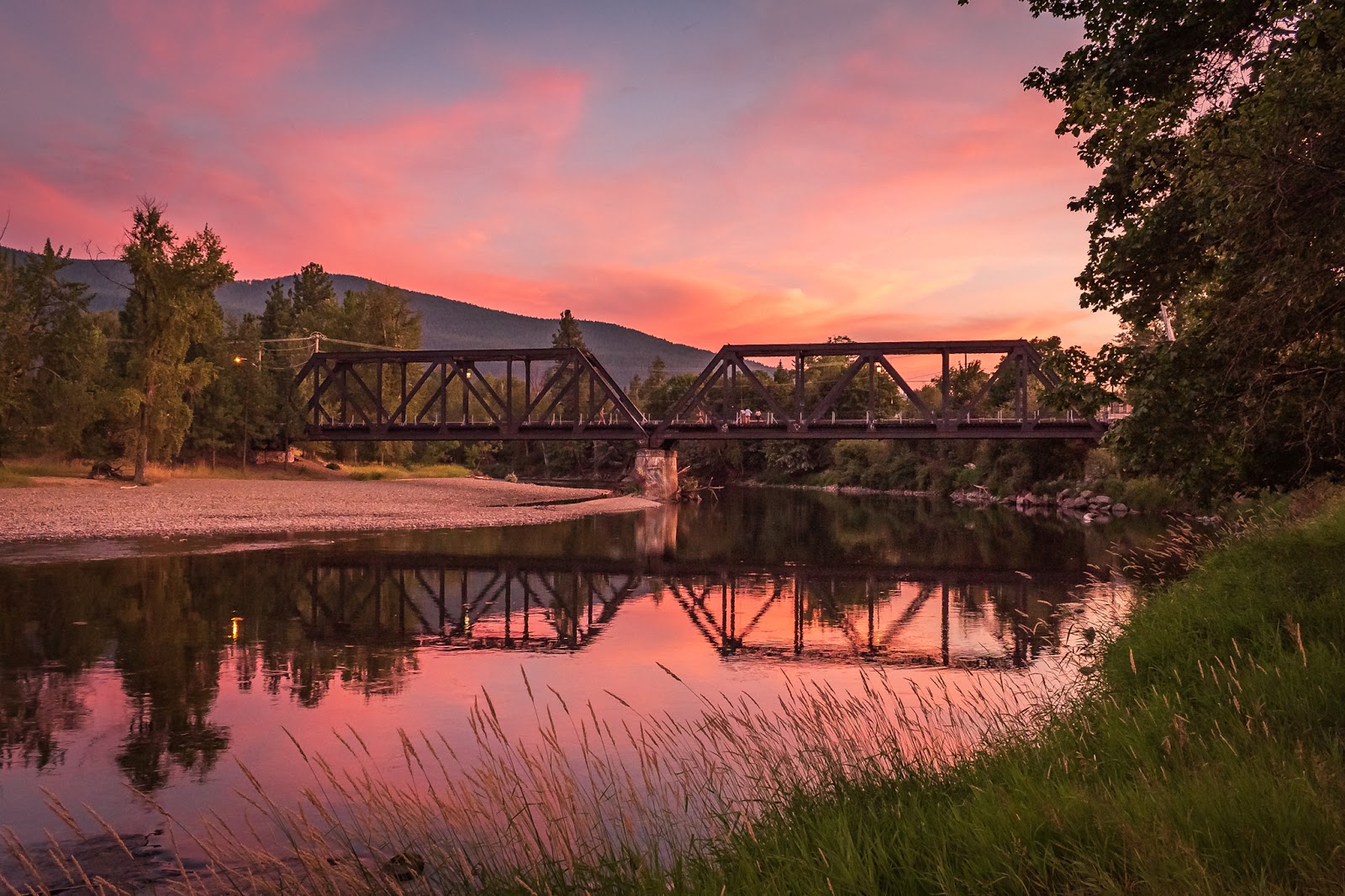
Highway 3 – The Winding Route to Adventure

Highway 3 from Hope to the Alberta border is soon to be known as the best-loved touring route in BC, thanks to a unique partnership to market the route to visitors. The Highway 3 Tourism Alliance—a collaboration led by three regions (Kootenay Rockies Tourism Association, Thompson Okanagan Tourism Association, and Vancouver, Coast & Mountains)—has just launched Hwy3BC.ca . The website showcases communities in BC along Highway 3, shares recommended itineraries, and encourages travellers to slow down to enjoy a classic road trip. Digital ads will promote fall travel. The website features itineraries and stories from the road that have been themed to engage traveller passion for adventures, like Arts & Culture, Historic Highway 3, Food, Craft Beer & Wine, Lakes & Rivers, and Outdoor Adventure.
This collaborative regional initiative activates the vision of the Destination BC led Destination Development Strategy and action-planning for Highway 3, co-created with tourism partners from the entire length of the route. This 2016 strategy identified the opportunity to feature the many adventures along Highway 3 and encourage travellers to slow down and enjoy a classic road trip, touring from community to community at all times of year with the intention of driving visitation and spending in more places, across more seasons.
With support from both the Provincial Rural Dividend Fund and PacifiCan Tourism Relief Funding, the three regional destination management organizations (DMOs) together with community DMOs worked with Victoria-based creative agency, The Number, to create a new brand identity for Highway 3. The new brand features a bold, modern take on the crow, inspired by the history of the Crowsnest Highway. Market research informed the website design and a digital campaign subsequently launched on September 5th to encourage autumn travel.
A corridor-long Festivals and Events strategy is also underway and the group hopes to continue their work together to secure funding and implement branded signage and wayfinding at key gateways and stops of interest.
Destination BC
Official websites.

HelloBC.com
Be inspired to start planning your BC Vacation.

Travel Media
Information for journalists, editors and broadcasters.

Tourism Business Portal
Online, self-service business listings system for tourism industry.
Subscribe to our newsletter
Getting Here
The Crowsnest is well connected with BC, Alberta and the USA.
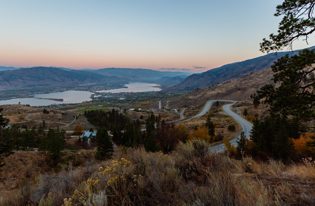
The Crowsnest Highway 3 runs east from BC and west from Alberta and hugs the Canadian and US border in BC’s Thompson-Okanagan Region. It continues to Alberta through BC’s Kootenay Rockies region.
The western section between Hope and Christina Lake is 393 km (244 mi) and has a driving time of 4 1/2 hours. So give yourself plenty of time to discover this road trip corridor – you could spend days discovering all the things to do and see.
Relax your pace driving this two-lane highway which meanders along the US/Canada border. From Vancouver, head East to Hope and take the Crowsnest Highway 3 through the Similkameen Valley . Travel onwards to Osoyoos , crossing Route 97 (North/South) and enter Boundary Country .
From Calgary, AB, drive south on Hwy 2 and venture west on Hwy 3 to access Boundary Country from the East.
Plan your own Route with Drive BC or view the Vancouver to Christina Lake route.
Our Visitor Centres are located in Hope, Manning Park, Princeton, Hedley (seasonally), Keremeos, Osoyoos, Greenwood, Grand Forks and Christina Lake. Each centre has Wi-Fi access and the friendly staff can answer any questions you may have. In addition, they can provide you with the latest information, directions, local knowledge and assist with making your reservations. While you’re there, be sure to pick up some brochures, maps, and other essential travel information.
Driving Distances to/from Osoyoos

- Your Profile
- Your Subscriptions
- Your Business
- Support Local News
- Payment History
- Sign up for Daily Headlines
- Sign up for Notifications
Cruise along this scenic highway in B.C. for a fall road trip to remember

Daydreaming of taking a fall road trip to a destination that has spectacular scenery, fresh mountain air, and all of the delicious food and satisfying wine, cider, and spirits you can have?
Then go ahead and picture yourself getting in your car or RV and cruising along the western Crowsnest Highway #3 in B.C.'s southern interior — located just two and a half hours east of Vancouver.
This must-drive route of Highway 3 connects the communities of the Similkameen Valley , Osoyoos , and Boundary Country , with the Similkameen Independent Winegrowers wine route.
With the long stretches of two-lane highway and rivers guiding you along the Crowsnest Highway, you’ll have plenty of time to connect with the various outdoor adventures and food and drink experiences when you visit this amazing region later this fall!
TRAILS, LAKES, AND RIVERS
From Manning Park to Christina Lake, the Crowsnest Highway will take you through systems of trails, lakes, rivers, and wide-open spaces that are accessible directly off the highway and are open for outdoor exploration.
You can embark on scenic activities outside when you hike or bike a mountain trail , go golfing in the valley, fish and float on the lakes and rivers , and bask under the sun on the beach well into the autumn months.
In the Similkameen Valley alone, you’ll find over 40 marked hiking and biking trails, including:
● E.C. Manning Provincial Park, which is filled with wildlife and wildflowers.
● Cathedral Provincial Park, which offers an unspoiled wilderness adventure above sapphire glacier lakes
● China Ridge Trails, which has over 45 kms of winding trails through the ridge.
● The Kettle Valley Rail Trail, which takes cyclists on a 40 km loop set in the lush countryside
● The Hudson Bay Company 1849 Trail, in which you can hike in the historic footsteps of the Hudson Bay Brigade
For a slower-paced adventure, go bird-watching at Swan Lake Nature Reserve or go relax at Bromley Rock along the Similkameen River — the heart of the valley.
The rugged and vast landscape of Osoyoos is alive with hills and grasslands that are perfect grounds for hiking, mountain biking, golfing, and wildlife viewing — all within access to the town centre. For the best views of the desert valley, take a stroll along the Irrigation Canal Walkway and the Golden Mile Trail. Home to Canada’s warmest lake, Osoyoos Lake, Osoyoos is the ideal spot for fall water activities such as kayaking, stand-up paddleboarding, and fishing.
The iconic rail trails of Boundary Country , including the Kettle Valley Rail Tail and Columbia Western Rail Trail sections of the Trans Canada Trail, all offer impressive views and are nearby local historical communities each with their own charm. And because they once were travelled by steam train, they tend to be flat or gentle inclines making for more easily accessible walking and cycling experiences. For adventures on the water, visit Christina Lake, set against the backdrop of the Monashee Mountains, or laze by the stream in Rock Creek in the Kettle River Recreation Area.
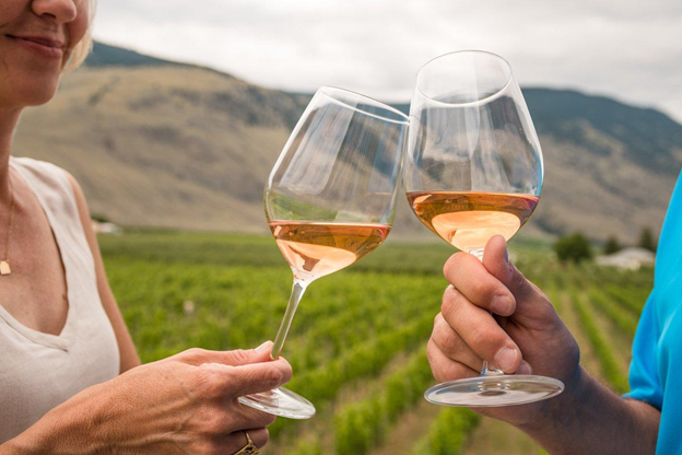
WINE, CIDER, AND SPIRITS
With an award-winning wine region, and budding craft breweries, cideries, and distilleries, there are plenty of opportunities to sip wines, ciders, and spirits as you soak up the sun and scenery along the Crowsnest Highway.
The Similkameen Valley Wine Region is home to the Similkameen Independent Winegrowers , a small, diverse, and unique group of over a dozen family-run boutique wineries and cideries. With vineyards and orchards set in a long curved valley with breathtaking mountains in the background, The Similkameen wine region is known for offering authentic wine tasting experiences with almost every grape varietal and many fruit wine options.
In Osoyoos Wine Country, you can try sought-after wines with unique varietals - like Tempranillo and Malbec, that flourish under the desert heat. Osoyoos is also the base for beer, craft cideries, and distilleries, all paired perfectly with incredible views of the valley’s landscape of gentle sloping hills, bright skies, and sparkling Osoyoos Lake.
Over in Boundary Country , you’ll find B.C.’s first female-owned and operated craft distillery. As a must-stop along the Crowsnest, you can try plenty of handmade organic spirits including whiskeys, gins, absinthes and Canada’s only artisanal rum!
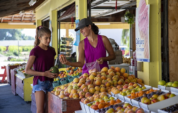
THE FARM-TO-TABLE EXPERIENCE
Indulge your senses in the widest variety of farm-fresh food in all of Canada when you experience the fall harvest along the Crowsnest Highway.
Autumn is the time when visitors and locals can stop by the fruit stands, markets, and farm-to-table restaurants of B.C’s southern interior. Bite into perfect peaches, taste tomatoes right off the vine, and enjoy the locally and sustainably grown fresh bounty of the region.
The Similkameen Valley is known as the Fruit Stand Capital and Organic Farming Capital of Canada, with the fruit orchards and vineyards of Keremeos and Cawston and the wild grass meadows of Princeton’s cattle country, making it the perfect stop for in-season ingredients and farm-fresh groceries.
For field-to-fork culinary delights, Osoyoos has everything from upscale dining experiences at vineyard-view bistros to cozy street-side cafés. The family-owned farms, orchards, and roadside fruit markets of Boundary Country are in abundance, so you can always stop and discover what’s fresh in the sunshine valley.
To access the Crowsnest Highway from Vancouver, head east to Hope and take Hwy 3 through the Similkameen Valley. Travel onwards to Osoyoos, crossing Route 97 (North/South), and enter Boundary Country.
For more info on the unlimited adventures in Crowsnest Highway, visit crowsnestscenic3.com .
- See a typo/mistake?
- Have a story/tip?
This has been shared 0 times
- Share by Email
- Share on Facebook
- Share on LinkedIn
- Share via Text Message
Is Vancouver's local news important to you?
Get your daily vancouver news briefing, more sponsored.

Must Sees on a Southern BC Road Trip
There is a lot to see in our province, and a southern BC road trip is a great way to see many amazing locations.
One of my favourite drives across British Columbia is the meandering Crowsnest Highway (Highway 3), which extends from Hope all the way through to Alberta.
While the scenery alone should captivate you along this southern BC road trip, there is also something unique to see in each town or city along the way.
You can start your journey at any point. However, to help keep this post organized, we will be moving west to east across BC. This has us starting on Highway 1 in Vancouver, connecting to Highway 3 in Hope, and carrying on to the Alberta border.

Vancouver offers a plethora of family fun, but here are a few of our favourites:
- Capilano Suspension Bridge Park – One of the more popular tourist attractions in Vancouver. If you go, you'll see why!
- Stanley Park – There is so much to see and do in Stanley Park it's hard to choose a favourite. You can walk the seawall, visit the animals at the farmyard, get up close and personal with sea creatures at the Aquarium , view totem poles, and/or swim in the heated freshwater pool at Second Beach.
- Science World – Vancouver's best museum for children
- PNE/Playland – The annual Fair at the PNE, with world-class shows and family fun, is on exhibit for 17 days starting mid-August. Playland, one of the most popular attractions of the PNE, is a 15-acre amusement park open from April through October.
- Stay in Vancouver – Here's a great list of Hotels in Vancouver

Langley / Aldergrove (Fraser Valley area)
About a 40-minute drive east of Vancouver (traffic dependent) you will come to the Fraser Valley. Here you will find heritage sites and exotic wildlife.
- Fort Langley National Historic Site – Inside the walls of this former fur trade post, timber buildings recreate the rugged 1800's.
- Greater Vancouver Zoo – If you are looking to view some wild and exotic animals, head to BC's largest zoo located in Aldergrove.
- Stay in Langley – If you are wanting to stay overnight in Langley or its surrounding areas, check here: Langley Hotels

Chilliwack / Cultus Lake
Chilliwack is a community that bills itself as the “Great Outside”. The towering mountains provide many opportunities for fantastic hikes, while the lakes and rivers provide locals and tourists alike with cool places to swim on a hot summer day.
- Cultus Lake Waterpark – BC's biggest water park, and where you will find some of the most extreme waterslides you will ever ride.
- Cultus Lake Adventure Park – Located just across the street from the waterpark, this adventure park is where you will find one-of-a-kind rides and attractions.
- Chilliwack River Rafting – Try river rafting for a wet and wild adventure down the Tamahi.
- Stay in Chilliwack – check out these hotels in Chilliwack
Hope / Manning Park
As a meeting point of highways travelling in all directions, Hope is a gateway destination to BC's most diverse scenery.
- Hike to the Othello Tunnels in the Coquihalla Canyon Provincial Park .
- Visit the marmots in Manning Park – The kids will be thrilled at how friendly these fuzzy little creatures are, but please remember they are still wild animals!
- The Hope Slide Memorial – View the largest landslide ever recorded in Canada. It's well worth pulling off the main highway to take in this massive natural disaster site.

This small town has a beautiful setting rich in history and heritage sites.
- Princeton & District Museum & Archives – This informative museum, with a wide range of historic collections reflecting Princeton's history, has kid-friendly displays they can actually touch.
- Stay in Princeton – check out these hotels in and around Princeton

Keremeos is a vibrant agricultural community located in the beautiful Similkameen Valley.
- Grist Mill and Gardens – is where you will find the last remaining pioneer flour mill in the West. This heritage site also offers gardens to explore, an exhibit building, apple orchard, gift shop, campground and restaurant.
- Stay in Keremeos – check out these hotels in and around Keremeos

Canada's only desert!
- You can't go to this desert town without swimming in the warmest waters in Canada. So Osoyoos Lake is the place to be!
- Osoyoos Desert Model Railroad – A world-class miniature fantasy world showcasing the biggest little European railroad in Canada.
- Rattlesnake Canyon – A western mining town themed amusement park only a block away from the lake.
- Stop at a fresh fruit stand and/or winery – Along with being known for great wine, Osoyoos attracts foodies from around the world because of its delectable local fruits and veggies.
- Spotted Lake – this lake is a sacred site to the local indigenous nation and is a sight to see!
- Stay here – check out these hotels in Osoyoos

Grand Forks
Grand Forks is a small town with a rich and diverse past.
- The City Park – Stretch your legs and walk along the Kettle River while on the ‘Spirit Trail' (previously known as the TransCanada Trail). Or perhaps let the kids burn off some steam at the beautiful play park canopied by gorgeous deciduous trees. The City Park is located in the downtown core, besides the Grand Forks Municipal Campground.
- Stay here – check out these hotels in Grand Forks
Castlegar is a small town steeped in the heritage and culture of the Doukhobors.
- Zuckerberg Island – Visit this Heritage Park with a swinging bridge, artifacts and buildings to explore.
- Doukhobor Discovery Centre – The Doukhobors played an important role in shaping the social and economic structure of the Kootenay region from 1908 – 1938, and the Discovery Centre acts as an excellent representation of the times.
- Stay here – check out these hotels in and around Castlegar

A perfect place for anyone in need of a wholesome home-away-from-home experience.
- Buy local food and drink – Drive throughout the scenic Creston Valley and stop in at farms offering gate sales. Or wet your whistle at one or all three wineries, and then hop over to the Columbia Brewery for a tour, and get your picture taken with the Sasquatch.
- Wildlife Management Area – Glide through the ponds and channels on a guided canoe tour, or walk along the kilometres of flat-top dyke trails with opportunities to view a large diversity of wildlife.
- Stay here – check out these hotels in and around Creston

Cranbrook (area)
Home to seven championship golf courses within 20 minutes of town, Cranbrook is known as a world-class golf destination.
- Go Golfing at Mission Hills – Try the three-hole mini-Mission geared towards families.
- Walk a historic neighbourhood – Take a self-guided walking tour of the historic Baker Hill district in Cranbrook, viewing elegant heritage homes of the 20th century.
- Fort Steele (16km Northeast of Cranbrook) – Step back in time in one of the most important heritage attractions in BC. While at Fort Steele enjoy old-time farming demonstrations, ice-cream making, train rides, horse-drawn wagon tours and gold panning. As well, watch live theatre performances and observe the museum displays.
- Stay here – check out these hotels in Cranbrook
The scenery here is breathtaking. The towering mountains offer a sharp contrast to the quaint ski town nestled below.
- Walk around the cute town and take in the outdoor adventure vibe
- Zipline & Aerial Park – Head to Fernie's Alpine Resort for a treetop adventure. There is even a mini obstacle course for younger kids.
- Bull River Horseback Adventures – Ride through some of the most spectacular mountain scenery in the world. Half-day, full-day, and over-night trips available.
- Stay here – check out the hotels in Fernie
Sparwood is the last town you come to in BC before entering Alberta through the Crowsnest Pass.
- View the Titan – See the world's largest truck located in the heart of Sparwood.
- Explore a Mine – Learn about the efficiency of 21st-century coal mining with a tour of one of Canada's largest open-pit mines.
- Stay here – there aren't too many, but check out the hotels in Sparwood
So, are you ready to take a Southern BC road trip yet?
If you feel like I have missed anything important or fun things to do along this Southern BC road trip route, please let me know in the comments.
Happy travelling!
To keep this post handy for future reference, don't forget to save this image to Pinterest:

Meet Kim Parcher, the creative mind and driving force behind Vancouver Island View. Kim's passion for experience-based travel and her talent for sharing valuable information have made her a dedicated niche blogger and freelance writer since 2016. Her unwavering dedication to unlocking the secrets of Vancouver Island, her home since 2009, has made her an undisputed authority in the realm of immersive exploration of the island.
Similar Posts

Getting to Vancouver Island by Ferry: A Spectacular Approach
Travel Tips and Convenient Vancouver Island Ferry Routes Are you planning your Vancouver Island getaway? Let’s dive into the practical ways of getting here! Nestled off the west coast of Canada, our beloved island can be reached by air or…

Steps from the Bustling Village
Location and Luxury at the Harbour House Hotel on Salt Spring Island When heading to Salt Spring Island, we choose the Harbour House Hotel as our top choice. This one is all about the location, with the added benefit of…

5 Days on Vancouver Island: A Road Trip Itinerary
Vancouver Island 5-Day Itinerary Nestled on Canada’s rugged western coastline, Vancouver Island is a haven for nature enthusiasts, thrill-seekers, and those seeking solace in the great outdoors. With its diverse landscapes, vibrant communities, and rich cultural heritage, Vancouver Island promises…

San Josef Bay and Cape Scott Provincial Park Guide
Cape Scott and San Josef Bay, Vancouver Island: A Pristine Wilderness Adventure If you are looking for a truly remote area of Vancouver Island, Cape Scott Provincial Park is it! Cape Scott offers a rugged coastal wilderness and beautiful unspoiled…

A Driftwood Creations Treasure Hunt
I have said it many times, but we have incredible talent here on Vancouver Island. This is most definitely the case regarding the large driftwood creations you can spot scattered around the island. You’ll find them on beaches, in the…

Best Ucluelet Vacation Rentals
We’ve researched for you and found you the best Ucluelet vacation rentals out there. These are the best Vrbo stays in Ucluelet, curated into one neatly packaged blog post. Ucluelet can be a bustling place, especially during the summer, and…
Nelson best little hippy town
Thank you for posting information and links all these cool little stops to check out. I just happened to stumble on this and it’s exactly what we were planning for our summer trip!
You are so welcome! I’m thrilled to hear that the article proves useful to you. Have a wonderful trip!
Leave a Reply Cancel reply
Your email address will not be published. Required fields are marked *
This site uses Akismet to reduce spam. Learn how your comment data is processed .
- Ways to Save
- Manage Membership
- Small Business
- Health & Dental
- Policy Wordings
- Underwriters
- Disclosures
- BCAA Auto Service Centres
- BCAA Auto Marketplace
- Evo Car Share
- Black Book®
- Approved Auto Repair
- Battery Service
- Electric Vehicles
- Partnerships
- Giving Back
- Using Our Voices
- Impact Report
How to plan and enjoy three epic BC summer road trips
Given the high demand for travel this summer and the surging cost of living (including rising costs of gas, food and more), it’s important to prepare before your next trip. Here’s our ultimate prep guide for BC adventuring and beyond, including tips on how to save money with your BCAA Membership. Happy road tripping!
Trip planning tips
Take more time to plan this summer. BC tourism businesses have re-opened, but it’s still not business as usual - many have adjusted their schedules and policies to ensure that you and their staff stay safe. Some may still be operating at a reduced capacity, with limited hours, or require advanced bookings.
- Save up to 25% by booking with your BCAA Membership at various BCAA Rewards Partner hotels .
- Find campgrounds through Discover Camping (BC Parks), BC’s seven national parks via Parks Canada , and rustic sites through Recreation Sites and Trails . You can also see the full list of campgrounds in BC on this map .
- Book RV rentals via CanaDream where BCAA Members save 5%.
...and be sure to check cancellation and refund policies before you book.
Get your vehicle road trip ready
- Avoid an unexpected breakdown with these 10 ways to get road trip ready .
- If your car has been sitting for a while or just needs some love, play it safe and book an appointment with one of our automotive experts at a BCAA Auto Service Centre . BCAA Members save 10% off the labour on brake repair, steering & chassis, suspension, wheel alignments and fluid flushes.
- Check your BCAA Membership plan to make sure you’ve got the right coverage in case of a breakdown. BCAA will help keep you moving, and with a Plus or Premier BCAA Membership , you’ll get up to 160/320km of towing distance. Be sure to upgrade or make any changes before you leave by logging in to your BCAA Online Account .
- Make sure your car insurance is renewed and your documents are in your vehicle. Consider getting a quick quote for BCAA Optional Car Insurance to see how much you could save on your collision, comprehensive and extended third party liability coverage.
- If you're travelling in an RV or recreational trailer, avoid common breakdowns with our RV road trip prep checklist and make sure you've added RV coverage to your BCAA Membership before you leave.
- Don't own a vehicle? Book an Evo for short trips around Vancouver and Victoria, or adventures to places like Whistler, Chemainus and Manning Park. Evo's per minute rate covers the gas, insurance, parking and unlimited kilometres. Bonus: BCAA Members get free Evo Membership, 60 free minutes and save 10%.

Plan your route and call ahead
- Stay safe and save time by checking road, ferry or weather conditions on your BCAA Mobile App before you go. Watch for any new health advisories , and map out your route with our online TripTik® road trip planner.
- If you drive a gas-powered car, BCAA Members can now save 3¢/litre on fuel and more at participating Shell stations* . You’ll also get 10% off car washes and products in-store! If you're driving an electric vehicle, plan your route by finding charging stations across BC at ChargeHub.com .
- Contact the local business(es) you plan on visiting. Call restaurants and attractions to confirm their hours of operation, understand capacity limits and make reservations in advance.
- Have a backup plan in case your first choice isn't possible. With so many travellers around BC this summer, activities may take longer than usual, or places may be at capacity when you arrive.
- Speak with local Visitor Centre staff to get advice on local attractions and adventures, and to learn how to support local businesses.
Pack smart and be prepared for emergencies
- Bring an extra set of keys and keep them with you when you’re outside your car.
- Don't forget the essentials: bring lots of water, your phone charger and a backup battery pack - they’ll all be critical in the event of a breakdown.
- Keep an emergency kit in the car including a first aid kit, warm clothing and blankets, a flashlight, windshield fluid, pylons, a high vis vest, and a fully charged portable battery charger. You can also order an all-in-one F.A.S.T. emergency kit where BCAA Members save 20%.
Take us with you!
Pro Tip: your BCAA Mobile App is the ultimate travel companion. In addition to helping you get faster Roadside Assistance, you can get real-time travel conditions and savings from BCAA Rewards Partners along the way. Learn more about how to get the most out of your BCAA Mobile App.

Three fantastic BC road trips
Want some travel inspiration? Discover (or rediscover!) BC with these three amazing road trip ideas:

Road Trip #1: Visit the beautiful towns and coasts of Vancouver Island
5-7 days, 500 km one way from Victoria
Make the most of summer by visiting some of the world’s most beautiful beaches, forests and waterfalls. Heading north out of Victoria, you’ll travel through Duncan, Nanaimo, Port Hardy, Parksville, the Comox Valley, Campbell River and Telegraph Cove. Highlights include:
- In Victoria, take in the historic sights and delicious offerings with this guide and see the Victoria Butterfly Gardens where BCAA Members save 10% on admission and the incredibly immersive IMAX® movie experience where BCAA Members save 15% on single admission 2D films.
- As you pass through Duncan, the “ City of Totems ,” stop to appreciate the beautifully carved totems of the Cowichan First Nation, who have called the area home for thousands of years. In Chemainus, explore the 40+ giant murals .
- Sip your way along the Vancouver Island Ale Trail (as long as you have a designated driver) or snack your way along the Nanaimo Bar Trail .
- Hit the incredible beaches between Ucluelet and Tofino .
- Gorge on delicious meals at these 10+ restaurants and food experiences including Pluvio in Ucluelet.
- Walk the Elk Falls Suspension Bridge in Campbell River.
- Get to know the wildlife that call BC home with a tour from Homalco Wildlife & Cultural Tours or Campbell River Whale Watching & Adventure .
- Continue north to immerse yourself in rugged landscapes, explore Indigenous culture and view wildlife along the way. Explore Telegraph Cove’s boardwalk village (it’s all on stilts) and check out Eco-adventures in Port Hardy like a kayak , seaplane or wildlife tour .
- Spend the night at the Kwa’lilas Hotel , an Indigenous-owned and operated hotel that uses local cedar designed to resemble a traditional big house with a smoke hole at the top of the building.

Road Trip #2: The Great Northern Circle Route
9+ days, 3,000+ km from Prince George
This epic, rugged, beautiful tour takes you northeast from Prince George up to Chetwynd, Tumbler Ridge, Dawson Creek, Fort St. John, Fort Nelson, Jade City, Smithers and Fort St. James. You’ll experience ancient forests, volcano-formed mountains and incredible waterfalls, fishing, mountain biking and camping.
Highlights:
- In Prince George, you’ve got to check out The Exploration Place Museum & Science Centre for its dinosaur models, interactive exhibits and steam engine train ride.
- An hour east of Prince George, you’ll find the Ancient Forest/Chun T’oh Whudujut Provincial Park , the only inland temperate rainforest in the world and home to western redcedars that are 1,000+ years old.
- In Chetwynd, check out the famous chainsaw carvings along the streets.
- At Tumbler Ridge, go on a Dinosaur Trackway Tour where you’ll hike to see dinosaur footprints at the Tumbler Ridge UNESCO Global Geopark .
- Love to fish? Head to Charlie Lake outside Fort St. John , to angle for trout, walleye, Arctic grayling and northern pike.
- Heading north out of Fort Nelson, watch for bison and Stone’s sheep, then camp at beautiful jade green lakes in the mountains at Stone Mountain Provincial Park and Muncho Lake Provincial Park .
- From Tatogga Lake near Stewart, see the geologically unique Mount Edziza , a spectacular volcanic landscape that includes lava flows, basalt plateaus, cinder fields and cinder cones.
- South of Smithers, visit Burns Lake and the Lakes District which offers 300+ wilderness fishing lakes and world class mountain bike trails.

Road Trip #3: Explore Highway 3’s Rugged Parks, Culinary Bounty & Mountain Towns
4-10 days, 247 km from Vancouver
For this epic road trip, travel the Crowsnest Highway through Manning Park, historic railway trails, the heart of wine country and some beloved BC mountain towns. Highlights include:
- Heading east from the Lower Mainland, make a relaxing detour to Harrison Hot Springs .
- Camp (drive-in or backcountry) and explore the wilderness in E.C. Manning Park Provincial Park .
- Spend a sunny afternoon floating down the Similkameen River (you can pick up a rubber tube from Hedley Country Market) or having a river-side picnic with goodies from one of the many local fruit stands.
- Enjoy wine tastings in the Similkameen Valley and Keremeos .
- Take a dip in Christina Lake , which gets its reputation as Canada’s warmest thanks to hot springs deep in the lake.
- See the Sculpturewalk in Castlegar , the ‘sculpture capital of Canada.’
- Looking for a unique place to spend the night? Sleep in a railcar in Cranbrook.
- Enjoy adventure at your own pace in Fernie: take a guided rafting tour , go hiking or biking , or take in scenic mountaintop views via the chairlift at Fernie Alpine Resort .
You can map out your road trips with our online TripTik® road trip planner, and for even more great BC road trip ideas, visit HelloBC.com .
Follow BCAA's Facebook , Instagram and Twitter as we share updates and trip ideas for your summer and beyond.
Not a BCAA Member yet? Join today and get BC’s Best Roadside Assistance for less than $8 a month. Plus, subscribe to our BCAA Member Rewards e-news to learn about exclusive BCAA offers, contests, deals and news.
Have a great summer exploring beautiful BC & beyond!

Enter for your chance to win a $10,000 BC Bucket List Adventure
Follow bcaa, get roadside assistance, request service online.
Click here to get started , it's quick and easy. We'll get someone out to you shortly.
Request Service in App
Call for roadside assistance.
*222 from your cell phone
1-888-268-2222 in BC
1-800-222-4357 in North America
You'll need to provide
Please Note: If you need a tow and also need a ride with one of our drivers, space is limited to one passenger. If you are experiencing any cold or flu like symptoms, we will ask you to wear a mask. Thank you for your patience and understanding.
Don't have a BCAA Membership?
Generic Heading
Here is a subheading for the Generic Modal
Need help? Contact us
What can we help you find?
BC Parks to Stay At Along Highway 3
in the Thompson Okanagan
June 26, 2018

@scramblersandadventureshttps://www.instagram.com/scramblersandadventures/
Jewel Lake Provincial Park
Carla Young, Route 97
Highway 3, or Crowsnest Pass, is a low mountain pass that runs along southeast British Columbia and southwest Alberta. You will travel through the Thompson Okanagan where the stunning mountains are backdrop to orchard and wine country.
BC Parks has a list of provincial parks to visit on your next road trip through the Similkameen Valley and Boundary Country
Conkle Lake Provincial Park
Swiws Provincial Park
Stemwinder Provincial Park
Bromley Rock Provincial Park
Read about all the Parks, originally published here .

@vitor_hugopxhttps://www.instagram.com/vitor_hugopx/
Connect with Route 97 on social media: Facebook ; Twitter ; Instagram
All content is Copyright SunCruiser Publishing Inc. but we do like to share. If you would like to use content from our site, please contact us at 1-866-609-2383.
The World As I See It
One Ontario lady with a passion for travel and inspiring others to get outdoors and explore more
- Canada / Travel
British Columbia Road Trip Guide & 4 Epic BC Road Trip Itineraries
by Bea · Published January 31, 2023 · Updated January 8, 2024
Vast landscapes, breathtaking natural beauties and abundant wildlife. The best way to experience it all is on a British Columbia road trip! British Columbia Canada spans an area of 944,735 km² and you likely won’t see everything in this westernmost province, so don’t even plan to. BC is bordered by the Pacific Ocean and the Rocky Mountains. The province is dominated by forests and lakes and is too beautiful of a place to rush through.
In this travel guide you find all the British Columbia road trip tips you’ll need to know before you go. Plus, the best driving routes so that whatever time you have for your visit, you can make the best of it.

Disclaimer: This post contains affiliate links. By clicking through and purchasing through these links I may make a small commission to help run this blog, at no extra cost to you. Thx!
Which season is the best for a British Columbia road trip?
Lots of factors make the summer months the most ideal time for a BC road trip. British Columbia in the summer is generally between May and September.
Summer days are long and the weather is generally warm and dry. This lets you enjoy the outdoors more and makes driving is easy, without any extreme weather conditions. Summer is the season to access high mountain trails and those wonderful alpine lakes. However, this makes summer the most popular and most expensive season too.
Between late October and April, drivers should be more cautious. Snow, fog and ice can affect driving conditions and the accessibility of the roads. Driving in the mountains in the winter is not recommended unless you’re an experienced winter driver.
If you decide to drive, your car needs to be prepared for winter conditions. Winter tires are a must, chains are recommended, and you need to be prepared for unexpected delays and sudden change of plans.
With that said, winter is the high season to visit the wonderful mountain ski resorts in BC. But Vancouver and most of Vancouver Island doesn’t get much snow. Instead, they get an extreme amount of rain. While you can have beautiful days in coastal BC in the winter, summer (especially July and August) guarantees a much drier and sunnier visit.

Where to start your BC road trip?
You’ll likely fly into Canada and rent a car (or an RV) for your road trip. There are three straightforward cities to fly to, and only two of them are in Canada. You can fly into Vancouver, Calgary (in the neighboring province of Alberta) and Seattle (in the USA).
Every BC road trip isn’t complete without visiting Vancouver , so you should start there. But Seattle is only about two hours’ drive away.
So, starting in Seattle is great for a longer West Coast road trip. The Calgary to Vancouver drive is roughly 12 hours. The scenic drive takes you to many of the world famous national parks in the Canadian Rockies.
Which are the best British Columbia road trip routes?
So, let’s see where exactly to drive. If you only have a few days, drive from Vancouver to Whistler on the Sea to Sky Highway. Or opt for a Vancouver Island road trip.
If you have one or two weeks, you can take a loop around the lower portion of British Columbia. Or you can drive from Vancouver to Banff.
The northern portion of the province is scarcely populated and underdeveloped. Plus, it takes a long time to drive there from Vancouver. For one or two week long trips, I recommend sticking to the southern portion of British Columbia. This area offers amazing parks, mountains and lakes than you can visit in a few weeks.
4 Epic British Columbia Road Trip Route Options

Sea to Sky Highway from Vancouver to Whistler Road Trip Itinerary
The Sea to Sky Highway is aptly named, as it truly takes you from the sea to the sky. The drive takes visitors from the scenic ocean views of Howe Sound to the snow-capped peaks of the coastal mountains.
Even if you only have one day, you can enjoy this drive on Highway 99 from Vancouver to Whistler. If you have 2 to 3 days, you can complete some of the longer hiking trails in the area.
If you visit the attractions of Vancouver before you begin your trip, Whytecliff Park is an ideal first stop on the Sea to Sky road trip. Located in West Vancouver, this small coastal park has a beach and a few elevated lookout points. Keep your eyes open for seals as they like resting on the rocks here, especially on Whyte Islet.
Further north, Porteau Cove Provincial Park is another great stop. It has a rocky beach, a pier and views of Howe Sound and the mountains towering above. As you head further north, you reach Shannon Falls. At 335 meters high, Shannon Falls is the third tallest waterfall in British Columbia. Plus, it’s just a short walk away from the roadside parking lot. This makes it one of the best short stops along the Sea to Sky Highway.
The Sea to Sky Gondola is also right by the road. It takes you from the highway up to the Summit Lodge within a few minutes. There you can enjoy the panoramic views over Howe Sound from the viewing platform. In addition, you can walk across the Sky Pilot suspension bridge or even go hiking.
Al’s Habrich Ridge Trail is our favorite trail in the area. The trail is a 7 km return hike that starts from the Summit Lodge. It treats you with wonderful mountain vistas all the way.
Stawamus Chief Provincial Park is the next stop. And it’s impossible to miss the giant peaks towering above the highway! Here, you’ll find one of the top hiking trails in Canada ! Conquering the First and Second Chief Peaks is a relatively short, but steep, challenging and rewarding hike. If you don’t have the time for hiking, simply stop at the roadside parking lot. From here you can marvel at the mountains directly above you.
Tantalus Lookout is definitely worth a stop. But you can only access it when you are driving southbound from Whistler to Vancouver. A left turn is forbidden on the northbound route. So, save it for your journey back.
Garibaldi Provincial Park is a stop for those who have time for long, exhausting, wonderful mountain hikes. Two great hikes are Garibaldi Lake Trail or the Panorama Ridge.
Brandywine Falls is another easy stop. With a few hundred meters walk to reach the viewing platform you can see Brandywine Falls. It’s a 70 meter tall beauty that flows over lava columns.
After Brandywine Falls, it’s about a 10 minutes drive to reach Whistler. You can stroll around Whistler Village, swim in Lost Lake or marvel at the color of Green Lake.
Optionally, continuing your journey to Pemberton allows you to experience a pretty mountain drive. Be sure to stop at Nairns Falls Provincial Park and One Mile Lake.
Sea to Sky Highway from Vancouver to Whistler Road Trip Details
Recommended length of road trip: 1-3 days
Route: Vancouver – Squamish – Whistler – Pemberton – Vancouver
Estimated driving time: 4.5 hours, about 306 km (there and back)

Southern British Columbia Road Trip Itinerary
This loop drive in southern British Columbia includes the Sea to Sky Highway, but also much more! Allow at least 10-14 days to experience it, because the driving distance is long. And there are lots of worthwhile stops on the way.
This scenic drive in British Columbia goes from Vancouver to Whistler, with all the stops described in the Sea to Sky Highway road trip above. In addition, the road trip from Whistler continues to Kamloops through Pemberton and Lillooet.
The mountainous landscape turns into a near-desert. Kamloops as a city doesn’t offer much to see, but you’ll find over a hundred lakes nearby.
As you carry on to Revelstoke, you get the mountain scenery back. The 26 km long Meadows in the Sky Parkway takes you straight up to the peak of Mount Revelstoke.
Revelstoke offers plenty of outdoor adventure activities. A few fun activities at Revelstoke Mountain Resort include the Pipe Mountain Coaster, mountain biking, and skiing.
Golden is your next stop! Plus, it’s a gateway to the beautiful Canadian Rockies. And arriving here, you reach the furthest destination in this route.
Now it’s time to drive back, but not on the same way. However, if you’re looking to extend your road trip, consider staying at Kicking Horse Mountain Resort in Golden.
Continuing your southern British Columbia road trip itinerary head south to Kelowna by the Okanagan Lake. Here you can explore the Okanagan Valley which is the most famous wine region in BC.
The drive continues to Osoyoos to find a true desert and the warmest freshwater lake in the Canada. Lake Osoyoos has average summer temperatures of 24°C.
Finally, get back to Vancouver via Hope. You can also stop in the unspoiled mountains of E.C. Manning Provincial Park or in Harrison Hot Springs.
Southern British Columbia Road Trip Details
Recommended length of road trip: 10 -14 days
Route: Vancouver – Whistler – Kamloops – Revelstoke – Golden – Kelowna – Osoyoos – Vancouver
Estimated driving time: 20.5 hours, about 1647 km (loop drive)

Vancouver Island Road Trip Itinerary
Vancouver Island is just off the mainland of BC, and it’s bigger than you’d think. So, the route I recommend here is not about everything you can see on Vancouver Island. But rather includes highlights of the island that you can see in a few days.
Start in the provincial capital, Victoria! Take a walk in the Inner Harbour and visit the Butchart Gardens. The gardens is a National Historic Site and is one of the best places to find cherry blossoms in Canada ! So, this British Columbia road trip itinerary is ideal in the spring.
Then drive to Nanaimo and Parksville, and head west towards Tofino. There are plenty of picturesque stops on the way.
Stops include Little Qualicum Falls, Englishman River Falls and the Hole-In-The-Wall in Port Alberni. You’ll drive through Pacific Rim National Park which means even more tempting stops!
If you’re keen to stretch your legs, you’ll find plenty of the amazing Vancouver Island hikes along this stretch. Take a walk on Long Beach, hike the short Rainforest Trail loops and chill out in Cox Bay.
Tofino is a small coastal town at the end of the peninsula. It has a hippie vibe and many surfers. Walk around in the lovely town center and harbor.
One of the best things to do in Tofino is hike the Tonquin Trail. This beautiful coastal hike leads to secluded beaches and awesome views.
Since Vancouver has ferry connections with both Victoria and Nanaimo, you can arrive in Victoria, then leave from Nanaimo at the end of your Vancouver Island road trip.
If you’re want add whale watching to your British Columbia road trip, Vancouver Island is a great place to do so. Try this Whale Watching tour that cruises through the Haro Strait in search of whales and other marine life.
Vancouver Island Road Trip
Recommended length of road trip: 3-5 days
Route: Victoria – Nanaimo – Tofino – Nanaimo
Estimated driving time: 7 hours, about 525 km

Vancouver to Banff Road Trip Itinerary
Finally, the famous road trip that connects Vancouver with Banff. Plus, the rest of the national parks in the Canadian Rockies. If you rent a car, I recommend picking it up in Vancouver and dropping it off in Calgary so that you don’t have to do the long drive twice.
First, head to Whistler on the Sea to Sky Highway. It makes your trip slightly longer, but the views are absolutely worth it. Then explore Southern British Columbia as you drive through Kamloops, Revelstoke and Golden. You’ll arrive in BC’s portion of the Canadian Rockies and the first national park of the adjoining four: Yoho National Park.
Yoho National Park is smaller than neighboring Banff. However, it has easily reachable, wonderful roadside attractions. Rent a kayak to explore Emerald Lake, which is named after its incredible color. Marvel at the rock formations at Natural Bridge. And walk to the roaring Takakkaw Falls, which is 373 meters high, in the Yoho Valley. Then drive further to reach Banff National Park and its world famous lakes, like Lake Louise.
A few other great stops to add in Banff National Park include the Banff Gondola for epic views. Plus, Moraine Lake and Johnston Canyon. You can stop in Canmore or continue on. Both the Trans Canada Highway and 1A take you through the scenic Bow Flats Natural Area. Both roads have a variety of beautiful scenic lookouts to stop at before arriving in Calgary.
Vancouver to Banff Road Trip Details
Recommended length of road trip: one or two weeks
Route: Vancouver – Whistler – Kamloops – Revelstoke – Golden – Banff – Calgary
Estimated driving time: 12.5 hours (1039 km)
I hope you enjoyed this road trip guide to British Columbia and all of its essential travel tips. With so many great British Columbia road trips, these route options offer the best way to travel around BC and see the top sights!
About the author: Bea is a passionate traveler, hiker and founder of In Love With BC. Her blog focuses on traveling and outdoor activities in British Columbia.
PIN IMAGE FOR LATER REFERENCE!

Tags: British Columbia Canada
You may also like...

20 Best Views in Toronto & Epic Toronto Lookouts
January 25, 2023
by Stephanie · Published January 25, 2023

Guide to Hiking in Romania & the Carpathian Mountains
September 24, 2018
by Stephanie · Published September 24, 2018 · Last modified August 16, 2020

25 Amazing Books Based in Canada
November 3, 2023
by Stephanie · Published November 3, 2023 · Last modified February 26, 2024
4 Responses
- Pingbacks 0
It’s my dream to do a Roadtrip in British Columbia. Thank you for sharing such a detailed blog post.
Thanks for sharing all this amazing road trip ideas! I am heading to Canada this fall and will definitely try to take one of these routes!
Fall is such a great time to visit! I hope you have an awesome trip!
The road from Banff to Vancouver is so scenic – I drove both ways a few years ago and was “wowed” the entire way!
Leave a Reply Cancel reply
Your email address will not be published. Required fields are marked *
This site uses Akismet to reduce spam. Learn how your comment data is processed .
- Next story +20 Best Things to do in Markham Ontario – A City Full of Culture, Fun & Food
- Previous story 19 Best Ontario Maple Syrup Festivals to Attend in 2024
Hey there, I'm Stephanie and am the gal behind The World As I See It. I have a passion for travel, hiking, and local travel in Ontario! Let me take you along on my journey exploring my own backyard - including Ontario small towns, cafes, and trails to cities around the globe. I hope you will be inspired to get out and explore your backyard and beyond!
TOP ONTARIO BLOGGER

TOP CANADIAN TRAVEL BLOGGER

- Privacy Overview
- Strictly Necessary Cookies
This website uses cookies so that we can provide you with the best user experience possible. Cookie information is stored in your browser and performs functions such as recognising you when you return to our website and helping our team to understand which sections of the website you find most interesting and useful.
Strictly Necessary Cookie should be enabled at all times so that we can save your preferences for cookie settings.
If you disable this cookie, we will not be able to save your preferences. This means that every time you visit this website you will need to enable or disable cookies again.
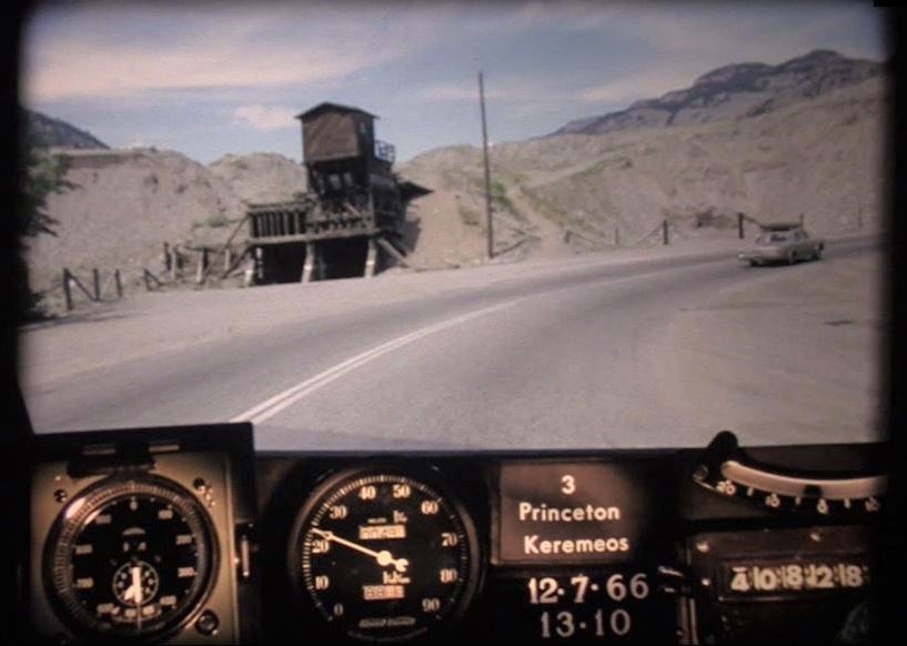
BC Road Trip Time Machine: Highway 3 from Princeton to Alberta Border, 1966
Beginning just outside of Hope and running along the southern edge of the BC and across the Alberta border, BC Highway 3 (also known as the Crowsnest Highway or the Southern Trans-Provincial), is an important route for travellers in and out of our beautiful province. These videos pick up where we left off in our last installment on BC Highway 3 as it travelled between Hope and Princeton . From Princeton, we head southeast past Hedley and Keremeos towards Osoyoos. From Osoyoos, the time machine travels east toward Creston. Leaving Creston, the time machine travels through Cranbrook, Fernie and onto towards Crowsnest. There’s a little bit of everything in these reels – small towns, rivers, mountains, valleys, orchards, lakes and more. So – climb in and buckle up – you won’t want to miss a frame.
Ch-Ch-Ch-Changes!
As with all things – the only true constant is change – and this route has seen its share of changes over time. Along with many standard safety improvements, such as widening, new alignments, improved signage, turning lanes and exits, the ministry has also worked hard to create new, more efficient connections between communities on the corridor.
Princeton to Osoyoos
Before the road through Richter Pass opened (connecting Keremeos directly with Osoyoos), travellers had to take Highway 3 north from Keremeos to Kaleden. From there, travellers then had to travel south towards Osoyoos and eastward again toward the Alberta border. The Keremeos – Kaleden route is now designated as Highway 3A.
Did You Know? Until the opening of BC Highway 97C (aka the Okanagan Connector) in 1990, Highway 3 was the fastest route connecting the coast of BC to the Okanagan.
Osoyoos to Creston
Many new alignments will be visible to locals familiar with this stretch. Gone are the Greenwood Tunnels (well, one tunnel does remain, but the highway now goes around it). Blink at 23:51 and you miss the community of Blueberry – now just a memory. In 1966, traffic had to pass through Salmo (via present day Airport Road) to travel west to Burnt Flat and Kootenay Pass. The Kootenay Pass (aka Salmo-Creston Cut-off) was only two years old at the time this video was captured. We counted five cars pulled over along the Kootenay Pass due to overheating – an issue that still happens today – as this is the highest point on the Crowsnest highway. Also notice, the “Big Cut” taking travellers to the intersection with Highway 3A isn’t there, meaning travellers had to go down Highway 21 and back up Hood Road to get there.
Creston – Cranbrook – Crowsnest (Alberta border)
Many parts of this stretch will look familiar to local travellers, including the community of Cranbrook. Wherever possible – the ministry continues to make improvements – such as widening, barrier installation and turn lanes for added safety. A big change to note since 1966, is the shuttering of the coal mining towns of Natal and Michel, close to present day Sparwood. This once thriving community is now only a memory, but time travellers can get some very cool snapshots of the community, as it was, near the end of the reel.
Community Names
Cascade, Kinnaird, Kaleden , Tadanac and Waneta were once communities significant enough to be used as directional start and end points to sections of highways in these photologs. While these communities still exist, their importance as a directional marker has “gone by the wayside”. Oh, and speaking of names, at the time this video was captured, BC Highway 3 was more commonly referred to as the Southern Trans-Provincial, reflecting its importance as a primary route in and out of the province. It wasn’t until 1977, that the entire stretch was officially named “Crowsnest Highway”.
Where Did These Videos Come From?
These videos are called “Photologs”. They were created by the ministry as a tool to capture road condition information across the province and give our engineers the ability to study a particular stretch of road without having to travel into the field. These original photologs were collected by rigging a camera onto the dash of a car which took still images every 80 feet or so and then running them all together as a single film. You can see them all on our YouTube channel .
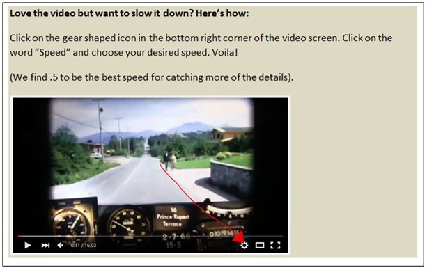
Video Moving Too Quickly?
Did you know that we slow these videos down to about 25 percent of their original speed before we share them? Even then, they can move pretty quickly. If you blinked and missed something – don’t worry – we’ve done the leg work for you and collected a great selection of still images over on our Flickr channel . Otherwise, follow the steps outlined in the image below, to reduce the speed even further.
What Did You See?
Did you notice something in this video that is long gone or something that has been there for, like, ever? Let us know what you see (or don’t see) in the comments below and stay tuned for more episodes as we work our way through the rest of the 1966 photolog footage.
Looking back on these old reels reveals a lot more than just pavement condition. The camera captured some incredible snapshots of our province during the 60’s. We loved catching a glimpse of three shirtless boys, walking along the highway on a warm summer day (gave us a real Stand By Me vibe). We also spotted a farmer driving his tractor and combine on the side of the highway in the Similkameen Valley, and a hitchhiker dressed all in black, just outside of Princeton. Oh, and – PUNCH BUGGY! No returns.
Want to see more about the history of BC highways? Check out these links below:
- BC Road Trip Time Machine: Travel Back in Time to the Interior of BC as it was in 1966
- A Brief History of the BC Highway Traffic Patrol
- Who is the Highways Department? A Study in Historical Pictures

Page 1 of 22 comments on “BC Road Trip Time Machine: Highway 3 from Princeton to Alberta Border, 1966”
Leave a comment cancel reply.
You must be logged in to post a comment.
hi tran bc editor. I was born in 1953. and we went on trips to the okanogan to Penticton .as this hwy 3 was the only way there .when I got older, I drove the dead buzzard Highway a lot. As a professional driver that’s what we used to call it Hwy 3. I and most people didn’t even know this type of photography ever existed. I would like to give credit to the people that have put this together, it is absolutely amazing to be able to go back in time and see this. I pulled that hill ,salmo to Creston many a time in my career. and my older brother lives in Cranbrook.the only thing I would say is your last pictures, are in wrong order Creston should be before Cranbrook.is there any reals of hwy 97 . out of hope up the Canyon North too, 100 mile ,Williams lake, Prince George etc.etc. again thanks too every one for the great work putting this all together.
Hi there, Terry
Thanks so much for your kind note (and the heads up about the ordering). The videos are a labour of love by yours truly. 🙂 We have captured the Fraser Canyon and are working on the stretch from Cache Creek to PG right now, so stay tuned. Here’s a link to all the videos we have done so far. Hope you enjoy. Safe travels. https://www.youtube.com/playlist?list=PLKHNpQ_j-IWG8CG_KN7cwl5mMO2bz2x8w
thanks again for all your hard work and team.the link u sent is very very cool .iam sending this out to my brothers. and grandkids etc .looking forward in see the 97 hwy north. I live near 100 mile.
Excellent – our Highway 97 between Cache Creek and PG is now live on the list: https://www.youtube.com/watch?v=ZaH7Yl3u5bc&list=PLKHNpQ_j-IWG8CG_KN7cwl5mMO2bz2x8w&index=37
Thanks again, Terry.
Thanks for the vid. Do you have the Hope-Princeton section for it? It would be interesting to see how it looked before the slide (if it predates it).
We do and you can watch it here: https://www.tranbc.ca/2016/09/22/travel-back-in-time-to-the-hope-princeton-highway-in-1966/
A note though, that this stretch was captured during the same time frame as the others – 1966 – which means it doesn’t capture the Hope-Princeton as it was before the slide. It does capture the post slide area very well though.
You might also be interested in this photo blog we created highlighting the area in the days after the slide occurred. https://www.tranbc.ca/2020/01/08/a-bc-highways-perspective-of-the-hope-slide/
Wow epic stuff I love it!!!
Thanks Dann. We think so too!
I travelled this route for the first time last fall(little window of opportunity) and absolutely fell in love! Look forward to doing it in more detail when we can travel again.
How lucky for you, Carolyn! It certainly is a beautiful stretch of road. Safe (future) travels!
Lots of excellent changes!!
We’re glad to hear you like it, Shirley!
Think I saw my dads 57 light green Ford parked along the road at Cominco (Teck) 25:59 when he was at work. Not many if any of that particular color in town at that time. Interesting how the camera was stopped just as it was starting to go through Cominco on a super smoky day. A few black frames then suddenly the area is much less smoky. And I also noticed a few broken down cars along the way. They most certainly were not as maintained/reliable as they are today. So many things I could say about parts of this video as I was 14 at the time.
Hello Steve – what a cool thing to see! It sure was smoky in the area at that time, wasn’t it. Our thought might be that the visibility was too poor to include those few frames? Let us know what else you can see!
As a kid, our family traveled from Langley to Cawston to visit my grandparents a couple of times a year pre 1966. Parts of the highway hasn’t changed much since then from Princeton. Still a nice drive and brings back great memories. Tricky part of the drive was Hope to Princeton and would be great to see some old footage of that part of Hwy 3
Thanks for your comments, Watne. The portion from Hope to Princeton has also been captured – here’s a link to more on that: https://www.tranbc.ca/2016/09/22/travel-back-in-time-to-the-hope-princeton-highway-in-1966/
Usually most summers I drive from Vancouver to Winnipeg to visit family. In 2019 I decided to take The Crowsnest instead of The Trans Canada through the mountains, let’s just say highway 3 was an incredibly enjoyable drive all the way from Hope BC to Medicine Hat AB. I found it to be much more scenic and the small towns along the way were interesting. Once I can travel again this will be the preferred route going forward. Amazing at how much has changed on it since ’66 though, incredible!
It certainly is beautiful! After producing these reels – yours truly has decided to do the same (when travel opens up once again). Thanks for sharing, Ken.
Great to see these old video logs. Many thanks Jasbir. If you see any for Hwy 97 between Penticton and Okanagan Falls circa 1980 please let me know. Many thanks John
We will add your request to the list, John. At this time, we are still working through 1966. Safe travels!
Awesome work.I drive on hwy no 3 pretty often,working for railway.Keep sending emails regarding this kind of work.Thank you.
Glad to hear you liked it, Jasbir. Thanks for commenting and safe travels!
- 15 Offbeat Digital Nomad Destinations You Need to Visit Now
- Cancun vs. Tulum - Which Should You Visit Next?
- How to Play Video Games as You Travel the World
- 21 Unusual Places to Visit in Poland You Must See
- The Best Cenotes in the Riviera Maya
- The 7 Best Vacation Destinations for Nature Lovers
- Work With Us
The 10 Best Road Trips in British Columbia, Canada
Looking to hit the road for the best road trips in British Columbia?
We’ve lived in BC for over a decade now, and while we haven’t driven every highway in the province, we’ve definitely taken our share of drives around our beautiful province.
British Columbia is Canada’s most western province. It borders Alberta, and is known for its vast size and natural beauty. Sandwiched between the Pacific Ocean and the Rocky Mountains, BC is world famous for its mountain ranges, lakes and glaciers, as well as rocky beaches, ski resorts and natural beauty.
There are numerous highways and scenic drives in British Columbia that make for some genuinely spectacular road excursions no matter the season, with thousands of valley lakes, mountains, and a largely unknown north.
The best road trips in British Columbia will not only take you through some of the most scenic areas in the province but also in Canada. You can visit the Okanagan Valley and see world class vineyards or drive along the west coast and hang out on beautiful beaches.
If you’re quickly looking for snow-capped mountains, head north from cosmopolitan Vancouver up to Whistler where you can ski or snowboard during winter months or go downhill biking in the summer.
Want to see salmon spawning or visit the Rocky Mountains in its rawest form? British Columbia has both.
Dreaming of warm mountain lakes in summer, natural hot pools year round and great hiking? BC has that in droves.
Whether you’re looking for the perfect place to take your family on a road trip, or you just want to explore some beautiful sights with your friends, there’s something in BC for everyone.
So whether you’re a local wanting to broaden your range, on vacation traveling with family or friends, or just want to get away from it all, here are some of our favourite drives in BC that will take you off the beaten path and into nature’s playground.
The best road trips in British Columbia, Canada
Whether you have your own car or are looking to rent a vehicle, these are the best road trips in British Columbia to take in the beautiful scenery of this Canadian province.
If you’re in the mood for a guided tour, BC has plenty of bus tours available and if you want to see the province unfettered, traveling the province by motorcycle is an amazing experience. Whether you’re looking for the best motorcycle insurance or want to check out the best things to see and do from Vancouver to Banff , this post has you covered.
The Sunshine Coast – Sunshine Coast Highway
The Sunshine Coast Trail is one of the most popular hikes in BC, and for good reason. It’s located just north of Vancouver on the coast, and offers a variety of different options for hiking. This includes a section that goes right along the water with stunning views of mountains and ocean alike.
What does this have to do with road trips? Well, not only can you stop and hike the trail, but getting there is also a beautiful drive with tons of great coastal views and mountainous backdrops along the way.
A few highlights along this route include the 2 ferry crossings (the first at Horseshoe Bay and the second at Earl’s Cove) with possibilities to see everything from whales to dolphins and even killer whales right from your vehicle. The majority of the drive is 2 paved lanes and large animal sightings are common so keep your eyes open for any fauna in the area including moose, deer, bears, mountain goats and cougars.
If you want to continue your drive once you reach Powell Bay, you can take a ferry over to Vancouver Island where you’ll start your island adventure near Comox.
The Okanagan Valley – Highway 97
The Okanagan Valley is home to some amazing wineries and fruit orchards that have been around before BC was even a province!
Starting up around Vernon and continuing south down to Osoyoos you’ll see some of BC’s prettiest lakes starting with Kalamalka Lake that, depending on the season, can range from cyan to indigo.
As you drive south from Vernon on Highway 97 through Lake Country and get into Kelowna, the heart of BC’s interior, there’s tons of things to do with the family including hanging out along the boardwalk of the 135 km (84 mi) long Okanagan Lake (one of the few lakes in Canada to never freeze in the winter) and grab an ice cream before heading to the beach.
As you continue through West Kelowna (home to great vineyards like Mission Hill and Quails Gate) you’ll soon find yourself driving through towns named Peachland and Summerland (great names right!) before arriving in Penticton . Make sure to walk the boardwalk in town before continuing your drive south down to Osoyoos, the warmest city in Canada!
If you love vineyards and cideries, there are literally hundreds in the Okanagan Valley with many just off the highway so pick up a winery guide available nearly everywhere in the valley before you start your Okanagan BC roadtrip.
The Coquihalla Highway – Highway 5N
The stretch of highway from Hope to Kamloops has 2 things in abundance, beautiful scenery and infamous notoriety. The Coquihalla features gorgeous mountain rivers and some beautiful mountain vistas however it’s also the star in a show called Highway Thru Hell, depicting the sometimes hazardous conditions that can occur during the winter months. Since it is a high mountain highway through some unforgiving terrain, there is some merit to the legends but if in doubt, check out the Drive BC website and just pay attention to the weather.
That said, the Coq was originally built as a connector to speed up the route that the Trans Canada highway originally took as it made its way west. While the drive is indeed faster via the Coquihalla, the beauty of the drive is also unmistakable.
If you’re feeling the urge for a hot soak, veer off the highway near Bridal Falls to check out Harrison Hot Springs .
As you leave Hope via Highway 3 East (make sure your tank is full since the next gas station in Merritt is 120km or just over an hour away), you’ll quickly jump onto Highway 5 heading to Merritt and Kamloops. If you want to get out and stretch your legs, the Othello Tunnels just past Hope are worth a hike
As you pull into Merritt itself (most of the town is to the north of the highway), you can now choose to continue northeast on Highway 5 to Kamloops or head southeast down Highway 97C to Kelowna and the Okanagan valley.
If you’re planning to drive right through either cities as you continue east, the drive south toward Kelowna will add half an hour to your journey however it is a prettier drive by far and takes you through several small towns and cities.
The Island Drive – Highway 1 and Highway 19
Though not officially called The Island Drive, navigating this section of Vancouver Island definitely fits the bill. As you leave Victoria, the Victorian architecture filled capital of British Columbia, and head north on Highway 1, you’ll pass quaint villages, pretty murals and get the occasional sweeping views of the ocean and the Gulf Islands.
There are hundreds of places to stop along the way to grab a bite to eat, hike or shop however there are a few wineries and cideries around Cobble Hill that are worth checking out. If you want a quick hike, it’s also worth checking the Kinsol Trestle just before Cobble Hill. It’s one of the tallest free-standing timber rail trestle structures in the world and is amazing to see. It’s part of the Cowichan Valley Trail and is a popular hiking area.
Nanaimo is the next major city on the way north. It’s not a bad place to stock up supplies for your Qualicum Beach stay (if you’re planning a short vacay) and is also the other major ferry terminal if you want to hitch a ferry back to the mainland.
As you continue north you’ll eventually reach picturesque Nanoose Bay and then Parksville, another major waterside destination in its own right though the long sandy beaches along Qualicum Beach are usually what attract the crowds.
While in the region, make sure to check out the Goats on the Roof (literally) at the Old Country Market as well as the North Island Wildlife Recovery Centre. Both are great places to take the kids and hang out for a few hours.
The Sea-to-Sky Highway – Highway 99
Not many people who visit Vancouver, often ranked as one of the best cities on earth, don’t take a day or two to make their way up to Whistler, BC’s premiere ski destination. The hour and a half roadtrip north up Highway 99 is filled with gorgeous ocean and mountain views and passes through Squamish, an outdoor lovers playground.
With everything from rock climbing to Bald Eagle viewing tours in the winter (it held the largest eagle viewing count in the world at 3769 with around 1300 spotted most given years), if you like the outdoors then likely Squamish has something for you. Squamish is also home to the wonderful Sea to Sky Gondola, a year round engineering marvel that zips you to the top in comfort with plenty of trails on either landings.
As you drive into Whistler, it’s quickly evident why it’s touted as an adventurers destination with a myriad of activities for the outdoor enthusiasts. After hitting the slopes, make sure to check out the town centre (known as The Village) with great shopping, restaurants and pubs open year round. Though we often think of Whistler as a winter destination, there are plenty of activities there happening year round.
Visiting in the summer? Check out Porteau Cove Provincial Park , a popular scuba diving destination with artificial shipwrecks and reefs supporting a huge variety of marine life, such as octopus, lingcod and starfish just minutes north of Horseshoe Bay. Don’t know how to dive? Take a course or explore the rocky beaches and go swimming in the ocean for a nice break from your road trip.
The Glacier Drive – Highway 5 and Highway 16
While Jasper isn’t technically in BC (it’s 20km from the BC/Alberta border), the vast majority of this drive is in British Columbia and it’s a beautiful road trip through valleys and mountains, with a few great sites along the way.
As you head up Highway 5 north from Kamloops, a great little city fronting the beautiful Thompson River and home to the BC Wildlife Park , you’ll pass wide open valleys that soon turns into winding mountain passes. The nicest part about this Kamloops to Jasper road trip is that the highway follows along the North Thompson River for a sizable portion of the drive, which makes for a great backdrop and gorgeous views.
Along the way, you can check out some amazing waterfalls or go whitewater rafting around Clearwater. If you don’t have time to check them out but want to stretch your legs, check out either North Thompson River Provincial Park right before Clearwater or the Blue River Provincial Park. Both are right along the highway and are easy to pull off into.
As you turn right (North) onto Highway 16 (known as the Yellowhead Highway) you’ll have another few places to stop with Rearguard Falls Provincial Park just on the right and then the Mount Robson visitor centre with Mt. Robson (the tallest mountain in the Rockies) as a nice backdrop. If you’re an avid hiker, the Berg Lake Trail (23km) is often considered one of the top 5 best hikes in Canada with plenty of gorgeous scenery and wildlife spotting.
Pulling into Jasper, it’s easy to see why it’s touted as one of the best destinations in Canada. From the stunning water colors of the Athabasca River and surrounding lakes, to its proximity to glaciers and icefields to the Sky Tram and Marmot Basin ski resort it has plenty to see and do including Canada’s best Dark Sky festival .
If you have the time, there are some of the most beautiful waterfalls in Canada less than an hour from Clearwater. Helmcken Falls, the 4th largest waterfall in Canada, in gorgeous Wells Gray Park is just one of them. You can also check out both Spahats Falls and Dawson Falls while on the way. Total time to Helmcken Falls is around 45 minutes (44km) one way.
The Cathedral Drive – Highway 4
Parksville to Port Alberni (Vancouver Island) – 50km (31mi) – 44mins
We only discovered this route a few years ago when visiting Port Alberni for the first time but it’s a quick, gorgeous drive through old growth forests and one of the prettiest walkways you’ll find on Vancouver Island.
Just as you pass picturesque Cameron Lake, past the halfway point of your journey, lies Cathedral Grove in MacMillan Provincial Park. This trail leads to the most accessible giant Douglas fir tree stands on Vancouver Island. You can walk the short number of trails under the shadow of giant Douglas-fir trees with some more than 800 years old.
Due to some severe windstorms over the years, some of the ancient trees have fallen and the park and trails are continually being monitored and repaired. Make sure you check to make sure it’s open if you decide to make the trip out there.
The Rocky Mountain Pass – Highway 1
The Rocky Mountains are a some of the most mountainous terrain in the world however the drive through them is often a very pleasant experience. Similar to Jasper, Lake Louise is only 10km from the BC/Alberta border so the majority of this road trip takes place in British Columbia.
Along the way, you’ll drive over Canada’s highest mountain pass, see a few hot pools, look up at the second tallest waterfall in Canada, traverse the premiere whitewater rafting river in the country plus witness some of the best scenery Canada has to offer.
Leaving east down Highway 1 from Revelstoke, a former train station hub and home to the great Revelstoke Mountain resort and Pipe Mountain Coaster, a 1.4km all downhill rollercoaster that barrels your way down a mountain, you’ll soon hit a series of boardwalks and trails. The one you don’t want to miss is Giant Cedars Boardwalk, a quick 20 minute walk through some extremely large cedar trees.
Right after that you have Canyon Hot Springs resort with a nice set of hot pools and soon after that you’ll be climbing through Roger’s Pass, the highest point along Canada’s 8000+km TransCanada highway.
As you arrive into Golden, Canada’s whitewater rafting capital, there are a myriad of adventures you can partake in like whitewater rafting or checking out the Golden SkyBridge, Canada’s highest suspension bridge and zipline site. After Golden you have Field, a cute mountain town with nearby access to Takakkaw Falls, Canada’s 2nd highest waterfall and around 10 minutes off the highway.
Once you arrive in Lake Louise, you’ll want to check out the gorgeous turquoise lake the town is famous next to stunning Chateau Lake Louise. There are some great hikes around the area and if you happen to be there in winter, Lake Louise Resort is considered one of the best ski resorts in Alberta.
If you want to read about more things to do along British Columbia’s TransCanada Highway, check out our ultimate Vancouver to Banff road trip guide .
The Pacific Rim – Highway 4
Traveling on Highway 4 west from Port Alberni to the coastal side of Vancouver Island is a leisurely affair with some beautiful coastal roads, some old growth forests and plenty of sights along the way.
As you leave Port Alberni, a small city on the Alberni Inlet, Vancouver Island’s longest ocean inlet, you’ll quickly pass Sproat Lake, a 4 season area with lakeside cabins and camping sites popular with fishermen and boaters alike. Next, you have Wally Creek. Right beside the highway with parking spaces, this is a perfect spot to jump in and cool off in the cristal clear blue water.
Continuing on you finally arrive at the coast. If you want to explore some of the natural beauty of the Pacific Rim National Park, now’s a great time to stop and grab a pass at the Pacific Rim Visitor centre. If you want a small detour, feel free to head south down to Ucluelet while first stopping off for a short walk around the Ancient Cedars Loop Trail.
To the north and towards our final destination of Tofino, another great walk is the Rainforest Trail that is a wood boardwalk & gravel trail through a veritable forest of cedar & hemlock trees covered in moss.
Next you have the Pacific Rim National Park Reserve with a tiny tourist town (Long Beach) on the edge of a nature lovers coastal retreat. Near endless stretches of beach attract surfers year-round however most visit simply to watch the waves and walk the miles of sand.
Soon you’ll be at the end of your road trip and driving into Tofino proper. This cozy town on the edge of the world is popular with surfers, nature lovers, whale watchers and hikers. In summer the population swells but it’s also a popular area year round with some great chefs and restaurants calling the town home.
Another popular surfing and beach spot in the area is Chesterman Beach on the southern outskirts of Tofino. There are plenty of inns and hotels in the area if you plan to stay for a few days.
The Kootenays – Highway 6, 31A, 31 and 3A
Unfettered nature is the best way to describe this road trip through British Columbia’s fabled Kootenays. Gorgeous lakes, relaxing hot springs, swaths of forests and a ferry ride are all highlights of this drive.
We first start in Nakusp, a nice beach village on the edge of the rather long Upper Arrow Lake. The Nakusp region is always busy in summer and has a gorgeous beach with clear water. As you head southeast out of town on Highway 6, you’ll soon be driving parallel to picturesque Slocan Lake. As you arrive into New Denver, a quaint village along the lake bank, you’ll soon be heading due east on Highway 31A.
As you drive over the Kokanee Glacier ranges, you’ll eventually reach Kaslo, a village on the west shore of Kootenay Lake in the West Kootenay region. If you want to stretch your legs, a quick walk along the Kaslo River Trail in town is a nice diversion and there’s a few good restaurants here as well. Further south of Kaslo, Fletcher Falls makes a great short pit stop with some nice little falls just off the highway.
Next we have Ainsworth Hot Springs, a favorite place of ours with some really nice hot springs and a heated hot springs cave. There’s also a delicious restaurant on site as well and if you stay in the hotel, the hot springs are included. Otherwise, they offer day passes for visitors.
After a lovely drive south along along Kootenay Lake we arrive in Belfour where it’s time to jump on a ferry over to Kootenay Bay as we continue down Highway 3A. The highway itself follows Kootenay Lake all the way towards Creston so don’t worry about getting lost now. Creston itself is a valley town with a variety of amenities, hotels and restaurants plus a few wineries and the Columbia Brewery (home of Kokanee beer) that gives brewery tours. If you’re there in summer, make sure to check out the wetlands at the Kootenay-Columbia Discovery Centre .
To get to Nakusp, you can either head due south from Revelstoke on Highway 23 or head east from Vernon on highway 6. Either roads are great however the additional cable ferry ride from Needle to Fauquier is a great bonus when driving in from Vernon and there are some great views and awesome lakes, namely Mable Lake, Sugar Lake and Echo Lake just off Highway 6 that are worth checking out as well if you have time.
Bonus Road Trip – The Island Highway – Highway 19N
Since no list is ever complete, we’ve decided to throw this last BC road trip in as a bonus. It starts in picturesque Comox.
In Comox you can check out the fisherman’s wharf or one of the numerous beaches such as Goose Spit Park. Kite surfing is a popular pastime here as well you’ll likely see some kites flashing by as you walk the many beaches.
Heading north up Highway 19, you’ll soon be arriving in Campbell River. The city is a very popular whale watching center as well as famously hosting grizzly bear tours. Either tour can be booked well in advance with several companies and some even guarantee a sighting or your next tour is on them. Another popular activity here is heading to Elk Falls Suspension Bridge with it’s large suspension bridge and waterfall as well as checking out the Quinsam Salmon Hatchery, one of the largest salmon hatcheries in Canada.
Continuing past Campbell River (make sure you fill up before leaving) you have a lot of land to cover that includes a few rivers plus a lake before getting back to the coast. Soon you’ll be pulling in to Port Hardy and able to check out the many beaches and marinas plus a plethora of day trips to places like God’s Pocket Marine Preserve to view sea lions. Taking a guided kayak tour is a definite must if the weather is nice.
You can get to Comox from the mainland via a BC ferry from Powell River so if you’ve done the road trip there then this route is a natural progression of it. You can also take a ferry from Port Hardy to Prince Rupert. If you plan to do this 16 hour ferry, renting a room on board is a great way to relax and see everything along the way.
Final notes on the best road trips in BC
After having our home base in BC for over a decade, we’ve had the opportunity to see a large portion of it and can never get enough of the beautiful scenery, the friendly people and the wild beauty. While this list isn’t exhaustive, we hope it gives you a few ideas of some of the best road trips in British Columbia and inspires you to visit and see the province for yourself.
Think we missed a hidden gem? We’d love to hear about it below. Safe travels.
Before travel to Canada this article is so helpful thank you 🙂
Leave a Reply Cancel reply
Your email address will not be published. Required fields are marked *
This site uses Akismet to reduce spam. Learn how your comment data is processed .
- Skip to primary navigation
- Skip to main content
- Skip to primary sidebar
British Columbia Highway News
Integrating BC Transportation Travel News Services and Products
Highway 3 Road Conditions
BC Highway 3 Road Conditions for the Crowsnest Highway Hope through to Alberta
Links to View Weather Cameras
Hope to Princeton through Manning Park Weather & Road Condition Cameras
Highway 3 Princeton to Osoyoos Weather Cams
Highway 3 Osoyoos to Salmo Weather Cameras
Highway 3 Salmo to the Alberta Border Cams
Road Conditions Report
BC Highway 5 Hope to the junction of Highway 16
Road Condition Report for the Okanagan Connector Highway 97C
British Columbia Highway 3 , officially named the Crowsnest Highway , is an 841-kilometre (523 mi) highway that travels across southern British Columbia. It runs from the Trans-Canada Highway (Highway 1) at Hope to Crowsnest Pass at the Alberta border. Highway 3 Road Conditions
Highway 43 Elk Valley Highway Road Report
Highway 33 Road Conditions to Big White
The eastern end of BC Highway 3 leads into Alberta. Check Alberta Road Conditions
Check Closures on BC Highways and Roads Today

- Flightseeing (Opens in new window)
- Boat Trips (Opens in new window)
- Glaciers (Opens in new window)
- Fishing (Opens in new window)
- Hiking (Opens in new window)
- Denali (Opens in new window)
- Wrangell-St. Elias (Opens in new window)
- Trail Tips (Opens in new window)
- Wildlife (Opens in new window)
- Marijuana (Opens in new window)
- Downtown Anchorage (Opens in new window)
- Arts & Culture (Opens in new window)
- Anchorage Trails (Opens in new window)
- Dining (Opens in new window)
- Coffee Culture (Opens in new window)
- Alaska Breweries (Opens in new window)
- Juneau (Opens in new window)
- Fairbanks (Opens in new window)
- Mat-Su (Opens in new window)
- Kodiak & Southeast Alaska (Opens in new window)
- Girdwood, Whittier & Seward (Opens in new window)
- Kenai Peninsula (Opens in new window)
- Valdez (Opens in new window)
A Seward Highway road trip promises epic adventures
:quality(70)/cloudfront-us-east-1.images.arcpublishing.com/adn/VVXIKOZYYVEORN3OEJX7CJ4URI.JPG "bc highway 3 road trip")
The skybridge above New Year’s Chute is one of two Veilbreaker Skybridges that collectively span 600 feet and are suspended 2,500 feet above the valley floor, at Alyeska Resort in Girdwood. (Emily Mesner / ADN)
Anchorage visitors venturing beyond city limits will find a scenic escape via the Seward Highway, a spectacular route with a surprising number of roadside diversions that culminates in a storied harbor town.
This renowned 125-mile roadway runs south from Anchorage to the town of Seward. The first portion follows alongside a narrow finger of water called Turnagain Arm. This historic waterway is named for British explorer Captain James Cook, who had to “turn again” when his ship reached its dead end.
Along the journey, the highway is framed by the dramatic Chugach and Kenai Mountains. Ancient glaciers peek through lush summertime greenery. Passing small communities, rustic roadhouses and pristine alpine lakes, the highway terminates in Seward on the edge of Resurrection Bay.
The time-pressed traveler could make it to Seward and back in one long, full day, logging five-plus road hours alone. But overnighting in Seward (or elsewhere) offers a more enjoyable and leisurely experience, and allows time to appreciate the Alaska scenery and character, along with the history, recreation and dining offered along the way.
About 45 minutes south of Anchorage, Girdwood is a laid-back ski town that relocated inland a few miles from the Seward Highway after the 1964 Good Friday Earthquake.
For Alaskans and visitors alike, Girdwood is a recreation mecca, with a charming collection of memorable restaurants, art galleries, ski chalets and condos. Winter slopes and ski lifts transform to host downhill mountain biking come summer. Paved paths thread through the town, offering an opportunity to take in scenery during a stroll.
:quality(70)/cloudfront-us-east-1.images.arcpublishing.com/adn/L3JJA7Z5PFCOJKIZLDH3U3VY4U.jpg "bc highway 3 road trip")
Jake Jankowski and Kelly McDermid walk along Glacier Creek near its confluence with Winner Creek. The area is a popular summer destination. (Marc Lester / ADN)
For hikers, the user-friendly Winner Creek Trail begins just behind the picturesque Hotel Alyeska. For a challenge, tackle the south end of the 21-mile Crow Pass Trail, which connects Girdwood to Eagle River’s outskirts north of Anchorage. The first few miles of the Girdwood end of the trail wind upward, with breathtaking views of glaciers, jagged mountaintops and remnants of long-gone gold mining efforts.
Girdwood’s dining options are impressively plentiful. Begin at a local icon, The Bake Shop, open as of press time Wednesday through Sunday, 8 a.m. to 2 p.m. A morning-time staple for 40-plus years, The Bake Shop features homestyle favorites like sourdough pancakes and sweet rolls. For lunch, the shop switches to homemade soups and sandwiches on fresh-baked bread.
For a special dinner experience, try Jack Sprat. Its regional cuisine with an Alaska touch is truly special, highlighting seasonal fresh produce and locally sourced protein such as halibut. The tall chalet windows offer romantic views of the mountainside. Check the restaurant’s website for hours.
Nearby, stalwart Double Musky Inn is a tucked-away steakhouse known for colorful French Quarter decor, a world-class wine cellar and spot-on Creole classics with Alaska flair. Its lively elegance has delighted locals and tourists alike for decades. There will be a wait many nights, but it’s worth it.
For a fun, relaxed vibe, pop by Girdwood Brewing Co. With indoor tables and outdoor seating around gas-fed fire pits, sip pints or smaller-pour taster glasses while ordering from one or more local food trucks that rotate on site; the truck schedule is updated on the brewery’s website. They also sell trendy hoodies, trucker hats and artsy stickers to remember your sudsy Girdwood detour.
Like Girdwood, Portage once sat alongside the Seward Highway, but after the 1964 quake, Portage faded away, with little remaining today but the remains of decrepit cabins overtaken by aggressive brush. In Portage’s place, visitors today will find the Alaska Wildlife Conservation Center (Mile 79 Seward Highway), a sprawling sanctuary across 200 acres that provides large-enclosure spaces for orphaned and rehabilitating Alaska animals.
View animals by either driving, walking the 1.5-mile loop encircling the center, or booking a tour with one of the staff naturalists. Hours are 9 a.m.-7 p.m. May 1 through Sept. 15. Check the website for additional hours.
:quality(70)/cloudfront-us-east-1.images.arcpublishing.com/adn/5R7MLA6IIRHERDGTIE7T3N3JHI.jpg "bc highway 3 road trip")
A Princess cruise ship is in port at Whittier. Small boats make their way around Passage Canal behind the ship. (Anne Raup / ADN)
An eastern turn at Portage down Portage Valley Road delivers motorists to the Begich, Boggs Visitor Center, and beyond that, the end-of-the-road town of Whittier.
As of this writing, the Begich, Boggs Visitor Center (Portage Lake Loop) is scheduled to open May 26, 2024. It sits about 5 miles east of the Seward Highway, a flat, pretty, quick drive. Named in honor of U.S. Reps. Nick Begich and Hale Boggs, whose flight in Alaska disappeared in 1972, the center is built on the edge of a lake on the moraine left by the receding Portage Glacier. The glacier is visible via boat trips to its front. The center itself offers science-geared educational opportunities for adults and kids alike.
Drive farther and travelers will encounter a truly different experience by way of the Anton Anderson Memorial Tunnel. The 2.5-mile-long, one-way toll highway tunnel is a dark and moody viaduct through the formidable mountains. The longest in North America, it was originally a train tunnel connecting the western side of Turnagain Arm to the military port town of Whittier. Find tunnel schedules online to time your visit accordingly.
Whittier exists as a critical deep-water port. In this unusual community, most residents call one of two large buildings home due to the lack of housing and buildable land. For activities, there are glacier-viewing boats, hiking and fishing. The town’s single hotel, the lovely Inn at Whittier, was closed early in 2024 after flooding; reopening updates will be posted on their website. Camping and RV options exist as well.
The one-way toll tunnel is strange enough to warrant a one-hour side trip. If you have time, visit the small but surprisingly comprehensive Prince William Sound Museum. An impressive number of exhibits fills its snug space, capturing the story of Whittier’s history.
Arriving in Seward is a show-stopper. As the highway ends at last, the view opens up to this special place that’s surrounded by the dramatic mountains ringing Resurrection Bay. Seward is home to an amiable community with a hodgepodge economy built on fishing outfits, kayak companies, sightseeing excursions, shops, restaurants and bars, plus there’s a beautiful boat harbor where visitors can walk the docks. About 2,625 people live here year-round, and summer cruise ships can deliver thousands of visitors a day.
:quality(70)/cloudfront-us-east-1.images.arcpublishing.com/adn/DX72COQ2ABBOPLTSYB63RXURJU.jpg "bc highway 3 road trip")
A humpback whale surface feeds in the company of opportunistic kittiwakes at the mouth of Resurrection Bay near Seward. (Erik Hill / ADN archive)
Highlights of Seward include the Alaska SeaLife Center, a hands-on aquarium and working science facility that boasts opportunities to ogle diving puffins and swimming sea lions, peer at octopus up close and learn about the special place that is Resurrection Bay.
From the SeaLife Center, a leisurely walk up Fourth Avenue provides a serene sense of Seward’s long-ago frontier culture, with Old West storefronts, historical murals, steepled churches and commemorative plaques and historical markers. A paved footpath that runs from the SeaLife Center along the waterfront toward the harbor is a pleasant way to enjoy the mountain scenery.
Seward has plenty of hotels and motels, home rentals, hostel beds, camping and RV options for those overnighting it.
Beyond the roadways, day cruises through Kenai Fjords National Park are a popular way to soak up the glorious waters of Resurrection Bay. Otters, seals, puffins, orcas and various migrating whales all may make cameos on these charters, some of which include island stopovers for meals.
To see a glacier by foot, carve out a couple of hours for a stop at Exit Glacier. Located just inside Kenai Fjords National Park, this glacier at the edge of Harding Icefield recedes annually, to the sadness of many fans. But a moderately graded walking path leads to overlooks where the glacier is still visible and can be photographed.
:quality(70)/cloudfront-us-east-1.images.arcpublishing.com/adn/5Q7VZYCL7BGCNBUQUTOBQYUPSY.jpg "bc highway 3 road trip")
Visitors to Kenai Fjords National Park get a look at Exit Glacier. (Marc Lester / ADN)
Seward is synonymous with fishing, and there are a bounty of half- or full-day charters that fish for halibut, salmon or both. Charters typically provide all fishing gear, and in town, there are options for having fish filleted and flash-frozen for shipping after your excursion ends. These trips depart early and return late and make for a full Alaska experience. Play your cards right, and you will enjoy the scenery of a wildlife-viewing trip while returning home with a freezer’s worth of fish to commemorate your unique and unforgettable Alaska vacation long after it’s over.
County Road 26 to open Monday for local, critical trips
Limited travel for commuters using the lake city cutoff opens after state and county collaboration as bridge closure continues.
Montrose and Gunnison Counties — This weekend, CDOT and Gunnison County are working together to accelerate improvements to County Road 26 (Lake City Cutoff) so it can open Monday for local commuter travel between Montrose and Gunnison. At the same time, engineers continue to conduct safety inspections of the US Highway 50 bridge crossing the Blue Mesa Reservoir at Dillon Pinnacles. This bridge, located west of Gunnison at Mile Point 136.3, closed Thursday in the interest of public safety after an inspection revealed a crack in one of the girders. The technical structure name for the bridge is K-07-B.
Recognizing the US 50 closure creates a significant detour for commuters traveling between Montrose and Gunnison, CDOT and Gunnison County officials this weekend prioritized getting a shorter access route in place for local travel between the two communities. That collaboration will continue as officials work to further fortify the road with gravel and manage traffic to a level that the road can safely carry.
“We are starting slow in order to increase the chances we can go faster later. The impact on western Colorado cannot be understated and we are exhausting all opportunities and partnerships to mitigate the impacts of the bridge closure,” said Martin Schmidt, Assistant Gunnison County Manager for Public Works.
On Monday, April 22, pilot cars will lead passenger vehicles through the access route two times a day in each direction. Because CR 26 is a high-mountain, unpaved road that is not intended to accommodate the traffic volumes of US 50, travel times will be limited and commercial vehicles exceeding a 16,001 gross vehicle weight rating are prohibited. The schedule for piloted travel is:
- 6 to 6:30 a.m. and 6 to 6:30 p.m. for westbound travel
- 7 to 7:30 a.m. and 7 to 7:30 p.m. for eastbound travel
The queue for westbound pilot car operations will start near the intersection of CO 149 and CR 26 and the queue for eastbound travel will start near the intersection of US 50 and CR 26. The travel time on the access route is expected to be 30 minutes or more.
County Road 26 will only be open for local, essential travel during these timeframes. The road will remain closed at all other times for the ongoing restoration work needed to ensure the road remains safe for travel.
A hotline and email continue to be in place to assist customers with questions about the closure. Anyone with questions can reach out via 970-648-4423 or [email protected] . Calls will be closely monitored and will receive a prompt reply. Information is also available on the project website at bit.ly/us50bridge . Travelers should refer to COtrip.org or the smartphone COtrip Planner app to plan an alternate route.
“CDOT appreciates Gunnison county’s dedication and hard work as we cooperate to offer more options to help the western slope manage this safety closure. CDOT will continue to support the county as we focus on the opening of County Road 26 to serve the critical needs of residents,” said CDOT Executive Director Shoshana Lew. “County Road 26 is an important local route that is up to five hours more efficient than detouring via state highways. However, this road currently has a natural roadbed and can only accommodate limited traffic - so it is important that we help Gunnison County focus this capacity on the needs of local communities most impacted by the closure.”
There are two recommended detours for through travel via Interstate 70 to the north or US 160 to the south and these detours add six to eight hours of travel time. CDOT is coordinating with emergency service providers to ensure emergency response is unaffected.
Travel Impacts
- US 50 is closed between Montrose and Gunnison
- Recommended alternate routes are I-70 to the north or US 160 to the south
- A limited, local detour is in place for travel at specific times
Project Contact Information
For additional information about this project, contact the project team.
- Webpage: bit.ly/us50bridge
- Information hotline: 970-648-4423
- Email: [email protected]
- Fact Sheet: County 26 Local Access
- Hoja informativa del proyecto: Ruta de acceso local en la County Road 26
Download the COtrip App!
The new free COtrip Planner mobile app was designed to meet the growing trend of information on mobile and tablet devices for the traveling public. The COtrip Planner app provides statewide, real-time traffic information, and works on mobile devices that operate on the iOS and Android platforms. Visit the Google Play Store (Android devices) or the Apple Store (iOS devices) to download!

The Happiness Function US
My Husband and I Did a 5-Day Road Trip Along the Most Iconic Highway in California: Here's Where To Stay, Eat, & Play
Posted: April 25, 2024 | Last updated: April 25, 2024

Our 5-day Highway 1 Road Trip itinerary covers Avila Beach, Cayucos, Cambria, San Simeon, and Baywood-Los Osos along the Central Coast of California in San Luis Obispo County.
A road trip along California’s famous Highway 1 is a bucket list trip if you love adventures with ocean views, wildlife, and fun outdoor activities.
My husband, Pablo, and I drove from San Luis Obispo (SLO) to San Simeon and are sharing what we did to help you plan your trip. From hiking and kayaking to foraging for seaweed, discover things to do, find the best places to eat (gluten-free friendly), and learn where to stay.
When Highway 1 Road Trip invited us for a hosted adventure, we jumped at the chance because we’d been dreaming of driving the iconic route for years.

How To Get There and Where To Start
If you’re not from California, like us, fly into the San Luis Obispo County Regional Airport (SBP). It’s a small airport and easy to get in and out of.
You’ll want to rent a car if you’re flying in. Pick up your vehicle at the airport by the baggage claim area (it’s super easy).
Start your adventure right from the airport and head southwest towards the coast to kick the day off at Avila Beach.
If you’re not flying in, no problem. Still, start at Avila Beach.

Where To Stay
Highway 1 is known for its cute artisan communities recognized for their laid-back coastal vibe. You can find boutique hotels and motels or inns overlooking the ocean. It’s the perfect road trip for adventurous couples and friends.

The Pacific Motel – Cayucos
We stayed at The Pacific Motel in Cayucos for half our road trip.
The owners take pride in what they have built. The motel has a hip surfer ambiance that is ideal for people wanting a relaxing and casual adventure near Cayucos. The rooms are trendy and within walking distance of the beach. They also serve a nice coffee bar in the morning.
The motel has fire pits, ping pong, a cute shop that supports local businesses, beach towels, beach chairs, and a beer and wine cooler. Guests can use beach cruisers from The Pacific Motel to get around town if they don’t want to walk.
It’s one of the cutest places we have stayed at, and we loved walking to breakfast and the beach every morning.

The Baywood Inn – Baywood-Los Osos
When we walked into our room at the Baywood Inn , we immediately ran to the huge windows and balcony facing Morro Bay.
Staying here is like staying in an apartment. There is a living room with vaulted ceilings, a fireplace, a small kitchenette, a bathroom, and a bedroom. It’s within walking distance of a handful of restaurants and an excellent location to access hiking, kayaking, and the Morro Bay Marina.
Breakfast is complimentary with your stay. When you check-in, the inn will tell you which restaurant is hosting breakfast.

Best Time To Visit
The Central Coast of California has a Mediterranean climate, meaning you can visit year-round. However, depending on the type of adventures you want, like getting in or on the water, spring, summer, and fall will have warmer temperatures. June, July, and August are busy, so be sure to plan ahead if you travel during the summer.
We visited during April. It was warm enough to wear a light jacket. Every day was sunny except for two days when the famous coastal fog rolled in. It was neat to see the fog, so it didn’t mess up our plans. We still hiked and explored until it burned off later in the day.
The wildflowers bloomed during our spring trip, and we saw the Elephant Seals. I can’t recommend the beauty of traveling along Highway 1 in the spring enough.

Explore Avila Beach, drive to Cayucos, check into The Pacific Motel, then walk Moonstone Beach in Cambria
Kick the adventure off by driving straight to Mersea’s for food near Avila Beach. We both got fish tacos – they were so good.
The restaurant is at the end of a pier. You might also see seals hanging out on the platform (we did). The water is a beautiful blue, and it will take your breath away.
After eating at Mersea’s, drive to Avila Beach a little down the road. You can access the beach here, and there are a bunch of boutique shops and restaurants.
Hit the road, drive towards Cayucos, and check into The Pacific Motel . If there’s still time in the day, drive a little further north towards Cambria and walk the Moonstone Beach Boardwalk . It’s pretty at sunset.
For dinner, Pablo and I had a wonderful garden patio dinner at Robin’s Restaurant in Cambria. When we visited, they served mouthwatering, handcrafted meals and even had gluten-free cheesecake. If you’re road-tripping with your dog, pets are allowed on their darling patio.

Day 2 – Morning
Tour Hearst Castle in San Simeon
Rise and shine. Then, walk to breakfast at the Hidden Kitchen in Cayucos. They have gluten-free waffles and breakfast tacos that are out of this world. Sit out back on their patio and enjoy oceanfront views.
After breakfast, hop in your car and drive Highway 1 north towards San Simeon to tour Hearst Castle . With the help of architect Julia Morgan, media mogul William Randolph Hearst funded the elaborate estate—the “who’s who” of the entertainment industry would retreat here by invitation only.
Today, you can take a guided tour to see all the magnificent art William Randolph Hearst collected from around the world. We thought the most interesting parts of the tour were walking through the gardens, seeing the Neptune Pool and the Egyptian Fountain, and walking across gold-plated tile in the Roman Pool. Online reservations to take a tour can be made 60 days in advance.
After we visited the castle, we drove to the Cavalier Coastal Kitchen . I ordered a BLTA on gluten-free bread, and Pablo got a fried chicken wrap that hit the spot. If you’d like to take in the views, a path is near the parking lot that overlooks the ocean. You might have the beach to yourself — we did.

Day 2 – Afternoon
Visit the Piedras Blancas Elephant Seal Rookery near San Simeon and go seaweed foraging in Cayucos
Drive to the Piedras Blancas Elephant Seal Rookery to work off your food coma. Located right off Highway 1, park your car and walk the trails along the coast to see the seals basking in the sun.
Walk to the north of the parking lot if you want to take photos — it has better vantage points. Watching the Elephant Seals was one of my favorite parts of our trip. Plus, it’s free to see them.
Did you know you can eat other seaweed besides the nori found around your sushi roll? During a seaweed foraging tour with Kelpful , you’ll learn all about the seaweed you can gather and eat. You can only do this special eco-activity when the tide is low. Visit Kelpful’s online scheduler to make a reservation.
We met our guide outside of Cayucos and walked down to the tide pools. We tasted raw seaweed from the ocean and saw crabs and an octopus while exploring. The experience was heartfelt, informative, and inspired us.
For dinner, check out the Lunada Garden Bistro . We walked there from our motel in Cayucos. They served up some of the best steaks we’ve ever had – and that’s not an exaggeration.

Day 3 – Morning
Hike Fiscalini Ranch Preserve outside of Cambria
From The Pacific Motel, walk to breakfast at Bijou Bakery in Cayucos . They have delicious gluten-free pastries (I got a lemon scone) and regular pastries (Pablo got a croissant). After enjoying a lovely breakfast on their patio, head back to the motel and pack up. Check out and drive toward Cambria to hike the Fiscalini Ranch Preserve .
We loved the trail along the bluff. There are neat spots to sit along the trail that remind us of Games of Thrones . Keep your eyes peeled for Harbor Seals – we saw one hanging out on the rocks. It’s free to hike here.
After, head into Cambria for lunch at Linn’s Restaurant . Try their famous Olallieberry pie – they have a gluten-free and regular pie crust. We were in pie Heaven.

Day 3 – Afternoon
Check into the Baywood Inn and walk El Moro Elfin Forest in the Baywood-Los Osos area
In the afternoon, drive south towards San Luis Obispo and check into the Baywood Inn . If you still have energy, drive and explore the El Moro Elfin Forest . It’s about a 5–10-minute drive from the inn, and you can get good views of the estuary. It’s free to hike here.
For dinner, Noi & Doi’s 2 nd Street Café , across from the Baywood Inn, serves some fantastic Thai food. The beef fried rice and green curry with tofu did not disappoint. We got ours to go and enjoyed a sunset dinner from our inn overlooking Morro Bay.

Day 4 – Morning
Kayak in Morro Bay
If hungry, drive 10 minutes into Los Osos and grab breakfast at Celia’s Garden Café . Pablo ordered corned beef hash, and I ordered an omelet. It reminded me of a good old fashion diner breakfast — they give you huge portions of food.
After breakfast, drive to A Kayak Shack at the Morro Bay State Park Marina. The manager at A Kayak Shack said the best time to paddle is early morning before the winds pick up, so keep that in mind. We did a self-guided trip and cruised around the bay. It was terrific, and we even saw otters.
Make sure you stay at least eight kayaks length away from the otters so you don’t stress them. If they get stressed, they could have trouble finding food or taking care of their young.
After kayaking, have lunch at the Bayside Café across from A Kayak Shack. Guess what we had? If you guessed fished tacos – you’re our people.

Day 4 – Afternoon
Hike at Monta ña de Oro State Park outside of Baywood-Los Osos
Montaña de Oro State Park is one of the largest state parks in California. We used AllTrails to find a hike that suited our adventure level for the afternoon. We walked along the Bluff Trail and loved it.
Along with a beach to sun at and enjoy the water, the Bluff Trail wanders along the ridge, and you get fantastic views of the ocean and rocky coastline. We even saw more otters (or seals) frolicking in the waves.
After hiking, if you’re up for some tasty Mexican cuisine, walk to La Palapa across from the Baywood Inn. I ordered chicken enchiladas, and Pablo enjoyed the carne asada. It hit the spot.

Check out of your inn, go to breakfast, and drive to the SBP Airport
On your last day, check out of your inn and head to breakfast in Los Osos. We grabbed pastries and lattes at Ascendo . It is right across from Celia’s Garden Café.
They did offer gluten-free muffins while we were there. I grabbed a gluten-free blueberry muffin and a chai latte, and Pablo ordered a croissant and latte.
After, find a place to gas up your rental and return to the SBP Airport.
We couldn’t believe how fast the trip went and were sad to leave. We honestly sat in the airport looking at real estate because we loved visiting so much and were dreaming about living in this area full-time.

More Towns To Explore Along Highway 1 Nearby
If you have more time in the area, you might also enjoy visiting Ragged Point, further north of San Simeon.
The Edna Valley wine region, Arroyo Grande Valley, Oceano, and Nipomo are south of San Luis Obispo.
Have a wonderful time. The area truly is remarkable.
Follow The Happiness Function on Twitter , Instagram , Facebook , TikTok and YouTube .
More Articles From The Happiness Function:
- I Went to Jasper National Park in the Canadian Rockies for Spring Break – It was Incredible
- I Went to Banff This Spring: Here Are My Favorite Places To Stay, Eat, & Play
More for You
Caleb Williams sent a cold-blooded text to new Bears punter Tory Taylor right after he was drafted
2024’s Canceled Shows, for Your Final Consideration
Average US annual salary by age revealed – see how you compare
'You were wrong!': Dave Ramsey takes a victory lap on his real estate prediction from 2 years ago and makes another prediction about what's next for housing
29 common human foods you may not realize are poisonous to your dog
You Won't Even Miss The Meat In This Flavorful Shroomami Burger
Dallas Cowboys Final NFL Draft Grades 2024: The Cowboys Build a Bully With Tyler Guyton, Marshawn Kneeland, Cooper Beebe, and More
I’m a Bank Teller: 3 Times You Should Never Ask For $100 Bills at the Bank
Things To Do After Beating Dragon's Dogma 2
Another Two Insurance Companies Intend to Withdraw From California Amid State Insurance Crisis
20 Loyal Dog Breeds That Will Never Leave Your Side
Farmers warn food aisles will soon be empty because of crushing conditions: 'We are not in a good position'
The #1 restaurant chain in America, according to diners—and see the rest of the top 50
The 43 Best Shows to Stream on Netflix Right Now
T.J. Hockenson trade results finalized: Here’s what Detroit Lions got
Here is the average credit score at every age in the U.S.—see how yours stacks up
Here’s What the US Minimum Wage Was the Year You Were Born
Muskox mom teaches baby how to head-butt in rare footage
‘We got it wrong:’ WeightWatchers CEO on weight loss
11 Facts You Should Know About Hard-Boiled Eggs
IMAGES
VIDEO
COMMENTS
Note: This story was originally published in 2021. Quirky wineries, historic railway trails, and fertile orchards are all part of the sweeping landscape along Highway 3 east of Hope.Also known as the Crowsnest Highway, this scenic route runs through the Similkameen Valley in the Thompson Okanagan and continues into the Kootenay Rockies.
From the Bottom to the Top of BC. Following a Highway 97 road trip route takes you through the Okanagan, along the Gold Rush Trail, and then even becomes the Alaska Highway. ... Coast to the Rockies by RV. Tips and route options to help plan an RV road trip from BC's coast to the Rocky Mountains. Routes include Trans-Canada Highway, Highway 3 ...
Part 1: Vancouver to Abbotsford. Part 2: Abbotsford to Hope. Part 3: Hope to Osoyoos. Part 4: Osoyoos to Castlegar. Part 5: Castlegar to Fernie. Rainforest to Rockies follows a road less travelled that connects the forest-fringed city of Vancouver to the rugged mountain town of Fernie. The scenic drive crosses plunging canyons, arid desert, and ...
Slow down to our pace and cruise the western section of the Crowsnest BC Highway 3. From Hope to Christina Lake you will travel through wide-open spaces, a diversity of landscapes and small towns and hamlets, connected by rivers and lakes. Hike a mountain trail, float the Similkameen River, visit fruit stands, markets and farm-to-table restaurant.
Premier Listings for Crowsnest Highway 3. Premier Listings for Crowsnest Highway 3 The Crowsnest Highway (Highway 3) runs from Hope at the east end of the Fraser Valley all the way east to the British Columbia-Alberta border in the Rockies. Sometimes called the Crowsnest Route or the Route of the Crow, Highway 3 is a memorial to a
Choose your road trip experience. Spring is here — kick off those boots — it's time for a road trip along BC's Scenic Crowsnest Hwy 3. Be awe struck by the changing landscape and wide-open spaces, meander at a slower pace along our two-lane highway — explore our lakes and rivers, take in leisurely walks or challenging hikes. Our trails ...
The website showcases communities in BC along Highway 3, shares recommended itineraries, and encourages travellers to slow down to enjoy a classic road trip. Digital ads will promote fall travel. The website features itineraries and stories from the road that have been themed to engage traveller passion for adventures, like Arts & Culture ...
The Crowsnest Highway 3 runs east from BC and west from Alberta and hugs the Canadian and US border in BC's Thompson-Okanagan Region. It continues to Alberta through BC's Kootenay Rockies region. The western section between Hope and Christina Lake is 393 km (244 mi) and has a driving time of 4 1/2 hours. So give yourself plenty of time to ...
Then go ahead and picture yourself getting in your car or RV and cruising along the western Crowsnest Highway #3 in B.C.'s southern interior — located just two and a half hours east of Vancouver. This must-drive route of Highway 3 connects the communities of the Similkameen Valley, Osoyoos, and Boundary Country, with the Similkameen ...
Travelling along the Crowsnest Highway - one of BC's major throughways, also referred to as the Interprovincial, Southern Trans-Provincial and Highway 3 (and, more locally, as the Hope-Princeton Highway) - you'll find plenty of places to refresh and rest up as you head east towards Osoyoos (or beyond). Osoyoos by Marcin Chady, Vancouver.
There is a lot to see in our province, and a southern BC road trip is a great way to see many amazing locations. One of my favourite drives across British Columbia is the meandering Crowsnest Highway (Highway 3), which extends from Hope all the way through to Alberta. While the scenery alone should captivate you along this southern BC road trip ...
Road Trip #3: Explore Highway 3's Rugged Parks, Culinary Bounty & Mountain Towns. 4-10 days, 247 km from Vancouver. For this epic road trip, travel the Crowsnest Highway through Manning Park, historic railway trails, the heart of wine country and some beloved BC mountain towns. Highlights include:
However, a few start in Victoria, which also has an international airport. You can also catch the ferry from Vancouver to Victoria, or even enjoy a seaplane flight and then rent a car once you arrive in Victoria. 1. Vancouver to Whistler Road Trip - Sea to Sky Highway (1 Day) Start: Vancouver. End: Whistler.
We've fired up the Road Trip Time Machine and pointed it at BC Highway 3 for a look at this iconic road as it was between Princeton and Creston, in 1966. Beg...
Jewel Lake Provincial Park. Carla Young, Route 97. Highway 3, or Crowsnest Pass, is a low mountain pass that runs along southeast British Columbia and southwest Alberta. You will travel through the Thompson Okanagan where the stunning mountains are backdrop to orchard and wine country. BC Parks has a list of provincial parks to visit on your ...
Sea to Sky Highway from Vancouver to Whistler Road Trip Details. Recommended length of road trip: 1-3 days. Route: Vancouver - Squamish - Whistler - Pemberton - Vancouver. Estimated driving time: 4.5 hours, about 306 km (there and back) Mount Revelstoke Southern British Columbia Road Trip Itinerary
The easiest way to explore British Columbia's natural beauty, small towns, and wildlife is by open road. Cross the province west to east on a trip to the Canadian Rockies, or find adventure from south to north along Highway 97 and the Alaska Highway. There are scenic trips along the coast, roads that explore local food and drink scenes, and ...
In 1966, traffic had to pass through Salmo (via present day Airport Road) to travel west to Burnt Flat and Kootenay Pass. The Kootenay Pass (aka Salmo-Creston Cut-off) was only two years old at the time this video was captured. We counted five cars pulled over along the Kootenay Pass due to overheating - an issue that still happens today ...
Tips and route options to help plan an RV road trip from BC's coast to the Rocky Mountains. Routes include Trans-Canada Highway, Highway 3, and Highway 99. ... From the Bottom to the Top of BC. Following a Highway 97 road trip route takes you through the Okanagan, along the Gold Rush Trail, and then even becomes the Alaska Highway.
The Sea-to-Sky Highway - Highway 99. The Glacier Drive - Highway 5 and Highway 16. The Cathedral Drive - Highway 4. The Rocky Mountain Pass - Highway 1. The Pacific Rim - Highway 4. The Kootenays - Highway 6, 31A, 31 and 3A. Bonus Road Trip - The Island Highway - Highway 19N. Final notes on the best road trips in BC.
As many of you already know, we've been digitizing 16mm photolog footage from 1966 to give you our BC Road Trip Time Machine video series. We love this stuff...
Road Condition Report for the Okanagan Connector Highway 97C. British Columbia Highway 3, officially named the Crowsnest Highway, is an 841-kilometre (523 mi) highway that travels across southern British Columbia. It runs from the Trans-Canada Highway (Highway 1) at Hope to Crowsnest Pass at the Alberta border. Highway 3 Road Conditions.
Enjoy one of the most picturesque stretches of highway in the U.S., with plenty of cute towns, great food and activities along the way.
We've fired up the Road Trip Time Machine and pointed it at BC Highway 3 for a look at this iconic road as it was between Princeton and Creston, in 1966. Beg...
Montrose and Gunnison Counties — This weekend, CDOT and Gunnison County are working together to accelerate improvements to County Road 26 (Lake City Cutoff) so it can open Monday for local commuter travel between Montrose and Gunnison. At the same time, engineers continue to conduct safety inspections of the US Highway 50 bridge crossing the Blue Mesa Reservoir at Dillon Pinnacles.
Our 5-day Highway 1 Road Trip itinerary covers Avila Beach, Cayucos, Cambria, San Simeon, and Baywood-Los Osos along the Central Coast of California in San Luis Obispo County.