
The Best Backpacking Trails in Pennsylvania
With roughly half the state covered in forest, it’s no surprise that Pennsylvania is home to some of the premier backpacking in the Mid-Atlantic. Home to sections of three National Scenic Trails, 122 state parks, and thousands of acres of state game land, Pennsylvania is bursting with places to explore. The state boasts over 35 trails and thousands of miles designated for backpacking. While some of these trails are considered long-distance and span hundreds of miles, others can be done in a few days. With all these choices, it may be hard to choose which PA trail to tackle for your next backcountry getaway. To help narrow it down, we’ve rounded up a list of the best backpacking trails in Pennsylvania.
From the hardest trail in the state to the most scenic, the following trails are a great representation of the diverse terrain the Keystone State has to offer hikers of all ages and experience.
Best Backpacking Trails in Pennsylvania
1. loyalsock trail.
Distance: 59.2 miles Difficulty: Moderate Approximate Time Frame: Four to six days

Loyalsock vista
About the hike: Stretching across beautiful Lycoming and Sullivan counties, the Loyalsock Trail offers grand views and challenging climbs. As one of the more established backpacking trails in PA, the route is well marked and includes an official guidebook, topo maps, and a trail log system developed by the Alpine Club of Williamsport. The trail closely follows Loyalsock Creek as it carves its way through the northern PA mountains, featuring multiple waterfalls and iconic mountain views. There are a few areas of the trail that are popular among day hikers, but for the most part you’ll have this trail to yourself, making this a great backcountry getaway .
2. Mid State Trail
Distance: 327.5 miles Difficulty: Moderate to strenuous Approximate Time Frame: Three to four weeks

The Midstate Trail. Image by Dylan “Pickle” Tonkin
About the hike: Traversing the height of the state from the Mason Dixon Line to the New York border, the Mid State Trail (MST) is a Pennsylvania classic. The trail sits almost entirely on a mixture of state forests, state game lands, and state parks, dubbing this “the wildest trail in Pennsylvania.” Although the MST may appear wild and remote, this is often an illusion as the trail is rarely over a mile from the nearest road, which makes resupplies easy on this three- to four-week trek. The trail is incredibly scenic and has been carefully constructed on ridgelines, offering as many views possible along the route. The MST is also the first (and one of the only) US trails to use the metric system on both trail signage and in the guidebook.
3. West Rim Trail
Distance: 30.5 miles Difficulty: Moderate Approximate Time Frame: Two to three days

The Pennsylvania Grand Canyon.
About the hike: The West Rim Trail is the most popular and most scenic backpacking route around Pine Creek Gorge, commonly referred to as “The Pennsylvania Grand Canyon.” The gorge is a National Natural Landmark and was named by Outside Magazine as the “Best Hike in Pennsylvania.” This mostly flat trail offers the best views of the gorge as hikers traverse the western side, and are able to stand right at the edge of the “canyon” at some points. Pass through seemingly endless fields of ferns and by the “Matterhorn of the Alleghenies” as you make your way between jaw-dropping views of the gorge.
4. Appalachian Trail
Distance: 229 miles Difficulty: Easy to strenuous Approximate Time Frame: Two to three weeks

Lehigh Gap, Palmerton, PA.
About the hike: Frequently known as Rocksylvania among AT enthusiasts, the Pennsylvania section of this 2,200-mile trail has gained a reputation for being challenging, rugged, and (you guessed it) rocky. Don’t let the moniker fool you, though—this section of the Appalachian Trail is full of hidden gems and must-see vistas. Starting as a smooth path through the evergreen-covered forests of southern PA, the trail traverses over ridgelines and gradually becomes steeper and rockier as you near the NJ border. Hikers on this section will cross several rivers, travel through multiple state parks, and even pass the official halfway point of the AT.
5. Laurel Highlands Trail (Potomac Heritage National Scenic Trail)
Distance: 70 miles Difficulty: Easy to moderate Approximate Time Frame: Five to seven days

Laurel Highlands Trail. Image via
About the hike: Nestled near the southernmost corner of PA, and right outside Pittsburgh, the Laurel Highlands Trail attracts visitors of all skill levels. While there are sections of trail that are easy enough for novice hikers to spend an afternoon in the woods, the trail is also full of steep climbs that challenge the most seasoned backpackers. The Laurel Highlands Trail is a major section of the Potomac Heritage National Scenic Trail (PHT), which “celebrates the heritage of the Potomac and upper Ohio river basins.” The PHT offers opportunities for hiking, biking, boating, horseback riding, and cross-country skiing, and allows users to experience historic pathways and cultural sites dating to the birth of the country.
6. North Country Trail
Distance: 180 miles Difficulty: Easy to strenuous Approximate Time Frame: Two to three weeks

The North Country Trail through Allegheny National Forest. Image via
About the hike: Traveling through one of the most scenic corners of the state, the Pennsylvania section of the North Country Trail (NCT) is perfect for those looking for a rugged wilderness experience. Meandering through Allegheny National Forest and past multiple groves of old-growth trees (including a 300-year-old white pine), this section of the NCT is one of the most established along the route. Clocking in at 1,600 completed miles, the trail will soon stretch over 4,000 miles and through seven states. However, Pennsylvania was the first largely completed section of the trail and is the most widely used. In addition to pristine wilderness, the trail passed by historic landmarks that tell the history of the area dating to times of early colonization and the Revolutionary War.
7. Black Forest Trail
Distance: 43.2 miles Difficulty: Strenuous Approximate Time Frame: Three to five days

View of Navel Run. Black Forest Trail, PA. Image via
About the hike: The Black Forest Trail (BFT) received its name from the dense hemlock stands that keep the surrounding forest in permanent twilight. The trail is one of the multiple backpacking routes centered around Pine Creek Gorge, and is by far the most challenging. Commonly known as the hardest trail in PA, the BFT is recommended for experienced backpackers, and successfully conquering the rugged terrain is no small feat. Hikers on this trail will take on exceptionally steep ascents and descents, but are rewarded with frequent views of Pine Creek Gorge, as well as multiple other “canyons” in the area. The route includes countless vistas and picturesque campsites, making the trail a crown hiking jewel for the state.

8. Quehanna Trail
Distance: 72.7 miles Difficulty: Moderate Approximate Time Frame: Five to seven days

Quehanna Wild Area on the Quehanna Trail. Image via
About the hike: Those on the hunt for a true wilderness experience should look no further than the Quehanna Trail. Partially set in Pennsylvania’s largest stretch of wild lands, known as the 50,000-acre Quehanna Wild Area, the trail is exceptionally remote. The area is known for pristine forest, mountain meadows, clear streams, and wild elk. There is one just one remaining herd of elk left in Pennsylvania, and members of this herd have wandered past their traditional lands near Sinnemahoning Creek and into the Quehanna Wild Area. This gives lucky hikers a chance to see these huge animals in their natural habitat.
From steep mountain climbs to a walk through history, Pennsylvania has something for backpackers of all types. The state is perfect whether you are looking to train for a thru-hike of one the Triple Crown trails, or just looking to spend a few days backpacking with friends. These are only a few of the 35+ backpacking trails in Pennsylvania. For a complete list of designated backpacking trails in the state, check out the York Hiking Club .
Did I leave out one of your favorite backpacking trails in Pennsylvania? Let me know in the comments!
Discover More

This website contains affiliate links, which means The Trek may receive a percentage of any product or service you purchase using the links in the articles or advertisements. The buyer pays the same price as they would otherwise, and your purchase helps to support The Trek's ongoing goal to serve you quality backpacking advice and information. Thanks for your support!
To learn more, please visit the About This Site page.

Hi! My name is Colleen, but I'm better known on the trail as Spot. I am a PA native who now calls the mountains of Colorado her home. My days are spent as a graphic designer and photographer, but I spend every available minute of my free time outside. A few years back, I discovered the AT and since then it has been the #1 thing on my mind. Since 2016 I have hiked over 1,000 miles of the trail, with plans to some day stand on top of Katahdin with all 2,200 miles under my belt. You can usually find me somewhere in the mountains either hiking, skiing, or rock climbing. Happy trails!

You left out the Allegheny Front Trail, a lovely 40 mile circuit of Black Moshannon state park.

Just did the BFT this weekend, in 2 days. Totally doable in a weekend even for me who has barely hiked in months. If you park on 44 instead of at Slate Run you can eat a meal/resupply at the store to make it a super chillax weekend. Cafe closes early tho- was at 6 when I was there last Sunday. Do it CCW, there’s a bit of a climb coming out of SR north but a nice camp right before. @eclecticwanderer for pics

In my 65 years of hiking here, out west, Nepal, etc, I have to rate BFT as favorite. 3 of the most beautiful campsites I have ever seen. Tough but wonderful. Did it several years ago with my daughter and would not trade the experience for a $million.

Hello, I have hiked most of the above mentioned trails. The BFT was the most recent. Might I suggest, if you are looking for a challenge. Check out the Donut Hole Trail. It runs through the North central section of pa. And has a connector to the Black Forest trail as well as the Susquehannock trail system (sts). The DHT has on average 7 thru hikers a year. I did this trip spring 2020. Might I add if you want remote, backcountry hiking in PA with strenuous climbs with some mega views. This it the trail for you. It was a tough 98 mile journey. With deer, elk signs and plenty of rattle snakes. But I may say that the DHT made the BFT fun. And if you want a true challenge maybe take a look into the DHT.

I’m so glad I found this post! I’ve been looking for some great backpacking trails in PA and this list is exactly what I was hoping for. I’m definitely going to check out the Delaware Water Gap Trail – it sounds amazing. Thanks for sharing!
What Do You Think? Cancel reply
2-FOR-1 GA TICKETS WITH OUTSIDE+
Don’t miss Thundercat, Fleet Foxes, and more at the Outside Festival.
GET TICKETS
BEST WEEK EVER
Try out unlimited access with 7 days of Outside+ for free.
Start Your Free Trial
Powered by Outside
Pennsylvania Trails
Pennsylvania is almost entirely covered by mountains and forest, and hiking in PA is always an adventure. The Appalachian Mountains, comprised of the Allegheny and Pocano ranges, cut through the center of the state. The 2,184-mile-long Appalachian National Scenic Trail , generally known as the Appalachian Trail, extends between Springer Mountain in Georgia and Mount Katahdin in Maine , passes through this area.
>", "path": "https://www.backpacker.com/trips/trips-by-state/pennsylvania-trails/the-great-eastern-trail-could-be-the-next-appalachian-trail-heres-how-to-hike-part-of-it-now/", "listing_type": "category", "location": "hero", "title": "The Great Eastern Trail Could Be the Next Appalachian Trail. Here’s How to Hike Part of It Now."}}' > The Great Eastern Trail Could Be the Next Appalachian Trail. Here’s How to Hike Part of It Now.
When it's finished, this in-progress long trail will let hikers take a stroll up the appalachians without battling the at's crowds., latest in pennsylvania trails, >", "path": "https://www.backpacker.com/trips/black-forest-trail-hike-pennsylvania/", "listing_type": "category", "location": "list", "title": "test yourself in the "grand canyon of pennsylvania""}}'> test yourself in the "grand canyon of pennsylvania".
The climbs on the Black Forest Trail are serious—but then again, so is the scenery.
>", "path": "https://www.backpacker.com/trips/go-with-those-in-the-know-tioga-county-pennsylv/", "listing_type": "category", "location": "list", "title": "Go With Those In The Know"}}'> Go With Those In The Know
Get the scoop on upstate Pennsylvania from Pine Creek Outfitters.
>", "path": "https://www.backpacker.com/trips/explore-pine-creek-pennsylvania/", "listing_type": "category", "location": "list", "title": "Explore Pine Creek Pennsylvania"}}'> Explore Pine Creek Pennsylvania
New adventure company Crooked Roots Adventures is getting people out on the river.
>", "path": "https://www.backpacker.com/trips/west-rim-turkey-path/", "listing_type": "category", "location": "list", "title": "The Best Day Hikes in America: West Rim-Turkey Path"}}'> The Best Day Hikes in America: West Rim-Turkey Path
Colton Point State Park, Pennsylvania
>", "path": "https://www.backpacker.com/trips/pennsylvania-wilderness-trails/", "listing_type": "category", "location": "list", "title": "Hike Pennsylvania's Only Wilderness Trails"}}'> Hike Pennsylvania's Only Wilderness Trails
Explore the northern Alleghenies' hardwoods on this 12.8-mile trek.
>", "path": "https://www.backpacker.com/trips/pittsburgh-pa-shorbs-summit-via-1000-steps-trail/", "listing_type": "category", "location": "list", "title": "Pittsburgh, PA: Shorb's Summit via 1,000 Steps Trail"}}'> Pittsburgh, PA: Shorb's Summit via 1,000 Steps Trail
Start on the 1,000 Steps Trail and then continue up Jacks Mountain to Shorb's Summit for a grand vista.
>", "path": "https://www.backpacker.com/trips/philadelphia-pinnacle-and-pulpit-rocks/", "listing_type": "category", "location": "list", "title": "Philadelphia: Pinnacle and Pulpit Rocks"}}'> Philadelphia: Pinnacle and Pulpit Rocks
This sometimes-steep 6.8-mile loop climbs hillsides carpeted with mountain laurel and hardwoods to two sweeping vistas overlooking the Lehigh and Cumberland Valleys.
>", "path": "https://www.backpacker.com/trips/philadelphia-wind-gap-to-smith-shelter/", "listing_type": "category", "location": "list", "title": "Philadelphia: Wind Gap to Smith Shelter"}}'> Philadelphia: Wind Gap to Smith Shelter
This 8.8-mile, out-and-back wooded hike runs the spine of the Appalachian Mountains to one of the most remote AT shelters in Pennsylvania.
>", "path": "https://www.backpacker.com/trips/philadelphia-blue-mountain/", "listing_type": "category", "location": "list", "title": "Philadelphia: Blue Mountain"}}'> Philadelphia: Blue Mountain
Hike the backbone of eastern Pennsylvania on this moderate 10.8-mile round-trip along the AT, which visits craggy overlooks with stellar views of eagles and hawks.
>", "path": "https://www.backpacker.com/trips/philadelphia-boone-trail/", "listing_type": "category", "location": "list", "title": "Philadelphia: Boone Trail"}}'> Philadelphia: Boone Trail
Spend a sunny afternoon on this 6.1-miler hike among the hardwoods of French Creek State Park, skirting two lakes with pleasant picnic spots.
>", "path": "https://www.backpacker.com/trips/scranton-pa-falls-trail-loop-to-adams-falls/", "listing_type": "category", "location": "list", "title": "Scranton, PA: Falls Trail Loop to Adams Falls"}}'> Scranton, PA: Falls Trail Loop to Adams Falls
Pass 21 waterfalls on this 6.2-mile, five-star loop through a wrinkled ravine and tranquil forest in Ricketts Glen State Park.
>", "path": "https://www.backpacker.com/trips/philadelphia-ridley-creek-state-park/", "listing_type": "category", "location": "list", "title": "Philadelphia: Ridley Creek State Park"}}'> Philadelphia: Ridley Creek State Park
Re-energize yourself on the White-Yellow Loop, a mellow 4.4-mile lasso to a serene picnic spot in this small park just 16 miles from center city.
>", "path": "https://www.backpacker.com/trips/philadelphia-lock-12-loop/", "listing_type": "category", "location": "list", "title": "Philadelphia: Lock 12 Loop"}}'> Philadelphia: Lock 12 Loop
Explore canal relics and tucked-away overlooks of the Mason-Dixon Trail on this 3.6-mile dayhike in Holtwood Environmental Preserve.
>", "path": "https://www.backpacker.com/trips/harrisburg-pa-governor-dick-park/", "listing_type": "category", "location": "list", "title": "Harrisburg, PA: Governor Dick Park"}}'> Harrisburg, PA: Governor Dick Park
This 7.9-mile stretch of Pennsylvania's historic 140-mile Horse-Shoe Trail boasts lookout-tower views, isolated terrain, and plenty of wildlife.
>", "path": "https://www.backpacker.com/trips/pittsburgh-pa-north-park-bridle-trail/", "listing_type": "category", "location": "list", "title": "Pittsburgh, PA: North Park Bridle Trail"}}'> Pittsburgh, PA: North Park Bridle Trail
This 5.8-miler in Allegheny County's sprawling North Park visits maple and oak forests, babbling creeks, and a scenic overlook.
>", "path": "https://www.backpacker.com/trips/cleveland-oh-slippery-rock-gorge-trail/", "listing_type": "category", "location": "list", "title": "Cleveland, OH: Slippery Rock Gorge Trail"}}'> Cleveland, OH: Slippery Rock Gorge Trail
Cross rushing creek, natural rock bridges, and a rugged gorge on this challenging 11.4-mile daytrip in McConnell's Mill State Park.
>", "path": "https://www.backpacker.com/trips/renovo-pa-bucktail-path/", "listing_type": "category", "location": "list", "title": "Renovo, PA: Bucktail Path"}}'> Renovo, PA: Bucktail Path
Discover one of Pennsylvania’s wild secrets in the Elk State Forest.
>", "path": "https://www.backpacker.com/trips/lassen-volcanic-national-park-rainbow-snag-lakes-loop/", "listing_type": "category", "location": "list", "title": "Lassen Volcanic National Park: Rainbow-Snag Lakes Loop"}}'> Lassen Volcanic National Park: Rainbow-Snag Lakes Loop
Tour lava beds, painted dunes, and a dormant volcano on this 12-mile hike in Lassen Volcanic National Park.
>", "path": "https://www.backpacker.com/trips/erie-pa-minister-creek-loop/", "listing_type": "category", "location": "list", "title": "Erie, PA: Minister Creek Loop"}}'> Erie, PA: Minister Creek Loop
This 6.4-miler loops through the lush forest surrounding Minister Creek, passing glacial boulders, wooded caves, and a plethora of streams.
>", "path": "https://www.backpacker.com/trips/pittsburgh-pa-greene-river-trail/", "listing_type": "category", "location": "list", "title": "Pittsburgh, PA: Greene River Trail"}}'> Pittsburgh, PA: Greene River Trail
A 10.3-mile out-and-back (or a 5.4-mile shuttle), this peaceful walk along the Monongahela River wanders through remnants of Pittsburgh's industrial past and present.
>", "path": "https://www.backpacker.com/trips/erie-pa-girard-loop/", "listing_type": "category", "location": "list", "title": "Erie, PA: Girard Loop"}}'> Erie, PA: Girard Loop
Discover the roots of the oil industry: western Pennsylvania.
>", "path": "https://www.backpacker.com/trips/pittsburgh-pa-laurel-highlands-trail/", "listing_type": "category", "location": "list", "title": "Pittsburgh, PA: Laurel Highlands Trail"}}'> Pittsburgh, PA: Laurel Highlands Trail
Witness southwest Pennsylvania at is wildest on a three-day, 31-mile shuttle along and over river valleys.
>", "path": "https://www.backpacker.com/trips/pittsburgh-pa-raccoon-creek-state-park/", "listing_type": "category", "location": "list", "title": "Pittsburgh, PA: Raccoon Creek State Park"}}'> Pittsburgh, PA: Raccoon Creek State Park
This 10-miler treks through babbling creeks, along an unending series of up-and-down slopes, and under the cover of white pine and hemlock forest.
>", "path": "https://www.backpacker.com/trips/scranton-pa-promised-land-state-park/", "listing_type": "category", "location": "list", "title": "Scranton, PA: Promised Land State Park"}}'> Scranton, PA: Promised Land State Park
Perfect for trail runners, mountain bikers, equestrians, and dayhikers, the trails at Promised Land State Park offer diverse outdoor opportunities at the base of the Poconos.
>", "path": "https://www.backpacker.com/trips/harrisburg-pa-kings-gap/", "listing_type": "category", "location": "list", "title": "Harrisburg, PA: Kings Gap"}}'> Harrisburg, PA: Kings Gap
Hike from pine plantation to mountain-top mansion on this moderate, 4.6-mile trek that climbs to a trail network atop South Mountain in Pennsylvania's Blue Ridge range.
>", "path": "https://www.backpacker.com/trips/pittsburgh-pa-south-side-steps/", "listing_type": "category", "location": "list", "title": "Pittsburgh, PA: South Side Steps"}}'> Pittsburgh, PA: South Side Steps
Climb a few of Pittsburgh's 700-plus stairways on this 3.2-mile urban loop that begins in the trendy South Side neighborhood and tops out with a skyscraper city view from a cemetery atop Mount Oliver.
>", "path": "https://www.backpacker.com/trips/lassen-volcanic-national-park-lassen-peak-trail/", "listing_type": "category", "location": "list", "title": "Lassen Volcanic National Park: Lassen Peak Trail"}}'> Lassen Volcanic National Park: Lassen Peak Trail
Ascend 2,000 feet in 2.5 miles to tag this 10,457-foot volcano with sweeping views of Mt. Shasta and Lake Almanor.
>", "path": "https://www.backpacker.com/trips/pittsburgh-rachel-carson-trail/", "listing_type": "category", "location": "list", "title": "Pittsburgh: Rachel Carson Trail"}}'> Pittsburgh: Rachel Carson Trail
Climb above the Allegheny River and see its serpentine course from a bluff-top vantage on this seven-mile point-to-point in Harrison Hills County Park.
>", "path": "https://www.backpacker.com/trips/pittsburgh-baker-trail/", "listing_type": "category", "location": "list", "title": "Pittsburgh: Baker Trail"}}'> Pittsburgh: Baker Trail
Follow yellow blazes for a 10-mile section across creek-laced woodlands. The route crosses a covered footbridge and is inter- spersed with pastoral vistas along a flat farm road.
>", "path": "https://www.backpacker.com/trips/rochester-west-east-gorge-loop/", "listing_type": "category", "location": "list", "title": "Rochester: West-East Gorge Loop"}}'> Rochester: West-East Gorge Loop
>", "path": "https://www.backpacker.com/trips/philadelphia-lavender-loop/", "listing_type": "category", "location": "list", "title": "philadelphia: lavender loop"}}'> philadelphia: lavender loop.
Hike along a gorge on this hidden, seven-mile gem in the City of Brotherly Love.
>", "path": "https://www.backpacker.com/trips/yellow-creek-pa-damsite-trail/", "listing_type": "category", "location": "list", "title": "Yellow Creek, PA: Damsite Trail"}}'> Yellow Creek, PA: Damsite Trail
Just an hour and a half from Pittsburgh, this easy 3.2-mile loop rolls through forests bustling with migratory warblers, passes the spillway of the Yellow Creek dam, and tours the shore of Yellow Creek Lake.
>", "path": "https://www.backpacker.com/trips/scranton-pa-falls-trail-loop-to-murray-reynolds-falls/", "listing_type": "category", "location": "list", "title": "Scranton, PA: Falls Trail Loop to Murray Reynolds Falls"}}'> Scranton, PA: Falls Trail Loop to Murray Reynolds Falls
Enjoy “the best waterfall hike in the East” on this 3.4-mile loop in Ricketts Glen State Park, which travels past 21 named cascades.
>", "path": "https://www.backpacker.com/trips/state-college-pa-west-rim-trail/", "listing_type": "category", "location": "list", "title": "State College, PA: West Rim Trail"}}'> State College, PA: West Rim Trail
Chase canyon vistas through stands of old-growth hemlock.
>", "path": "https://www.backpacker.com/trips/rip-go-west-rim-trail-tioga-state-forest-pa/", "listing_type": "category", "location": "list", "title": "Rip & Go: West Rim Trail – Tioga State Forest, PA"}}'> Rip & Go: West Rim Trail – Tioga State Forest, PA
>", "path": "https://www.backpacker.com/trips/pennsylvania-s-michaux-state-forest/", "listing_type": "category", "location": "list", "title": "pennsylvania's michaux state forest"}}'> pennsylvania's michaux state forest.
With all of the trail options in Pennsylvania's Michaux State Forest, it's hard to pick just one.
- Sleep Systems
- Trekking Poles
- Camp Kitchen
- Accessories
- e-Gift Cards
- Backpacking 101
- Expert Articles
- Returns & Exchanges
- Search by Map
- Browse List

Best Backpacking Trips in Pennsylvania
Did you know that half of Pennsylvania is covered in forest? And, thanks to glacial activity 10,000 plus years ago, there are plenty of rolling hills and valleys too. Don't forget the Pocono and Catskill mountain ranges either. These features lend themselves to some beautiful vistas. Plus, the overall weather is fairly cooperative. That said, the Keystone State is a great place for a backcountry excursion.
With plenty of state parks, state forests, and other natural areas to explore, lots of trails await. You're sure to find an enjoyable hike for any difficulty level. Here are some of the best Pennsylvania hikes to check out on your next backpacking trip.
Featured Photo: Upper Rock Run Gorge ( photo by Nicholas T. )
Pennsylvania Grand Canyon West Rim Trail
Did you know Pennsylvania has its very own miniature Grand Canyon? As you can guess, it's a lot greener than the one out west. It's just as interesting in its own way, though. The West Rim Trail is in the north-central part of the state. At 30 miles long, this point-to-point trail features lots of vistas of the Pine Creek Gorge and overlooks of Barbour Rock and the Allegheny Plateau. For optimal viewing (and fewer bugs) head there in the fall for the beautiful foliage. For more details on the West Rim Trail, check out our full write-up .

Source: Flickr
Old Loggers Path
A good loop trail is hard to find. If that's what you seek, check out the 27-mile Old Loggers Path. It can be found in the northeast corner of the state in Loyalsock State Forest. Rated as difficult, you'll follow old forms of industrial transportation, like railroads. The trail offers stunning vistas over the McIntyre Wild Area and Pleasant Stream. You'll be mesmerized by the lush undergrowth in the wooded areas too. Another highlight is Rock Run, a beautiful boulder-lined stream with relaxing cascades and swimming holes.
Black Forest Trail
Up for a challenge? Try this 43-mile loop in Tiadaghton State Forest. The trail got its name from the thick hemlock forests of yesteryear, which are mostly gone now. But, it still offers a growing forest of hardwoods and excellent views of the surrounding mountains.
You follow a stream for the most part, so you will never have to look far for water to filter. Be prepared for all of the stream crossings with extra shoes and socks. The numerous ups and downs can be tiring. There is also one area you will have to do a little rock scrambling. Plenty of campsites await. But, you may have to trade off views for being close to a water source and vice versa.
Appalachian Trail (Michaux State Forest)
Looking for a shorter hike? Try out this section of the AT. This 17-mile hike runs from Pen Mar Road to US 30 in the south-central part of the state. It's so far south that it starts near the Mason-Dixon Line! Like many other trails in Pennsylvania, it travels near old railroads.
One of the hike's features is the awesome view from Chimney Rocks. You'll likely encounter the most people here because it's a popular day-hiking area. Don't skip the very short side trail to the view of Green Ridge and the Waynesboro Reservoir either.
Water shouldn't be an issue on this trail because there are several creek crossings. This section also boasts some of the nicest shelters along the entire AT (4). You can extend your hike by heading further north to Caledonia State Park.
Allegheny Front Trail
A lot of times it can be hard to find loop trails. But this state seems to be full of them! The Allegheny Front Trail travels 42 miles through Moshannon State Forest. This is almost dead center in the state, making it easily accessible from many parts of PA. Rated as moderate, hiking clockwise is said to be easier.
This trail has a little bit of everything, from mountaintop views to wetlands with a variety of forests in-between. You'll find rhododendron thickets common to the mountains of the state too. Boardwalks help keep your feet dry in boggy areas. But, there are lots of small stream crossings too. Admittedly, this trail isn't full of vistas. The ones that are there are worth the trek, though. Dispersed camping is not allowed within Black Moshannon State Park, so plan accordingly.

Source: Flickr
Cook Forest State Park
Looking for a base camp trip or something to ease newbies or kids into backpacking? Consider staying at Cook Forest State Park. While there aren't any backpacking options, we thought the landscape features here were cool enough to highlight.
47 miles of trails are waiting to be explored. The North Country Trail section isn't to be missed. It's a doable 12 miles and features Forest Cathedral, Hemlock Island, and Seneca Point. It also boasts hard-to-find old-growth forest. The misty stream and verdant undergrowth will make you think you've been transported to the Pacific Northwest.
Laurel Highlands Trail
One of the most popular backpacking trails in the state is the Laurel Highlands Trail. It is 70 miles point-to-point, so you'll need to arrange a shuttle. Located in western Pennsylvania, it follows Laurel Mountain through several state parks and forests. It will keep you on your toes from flat, easy walking to rugged, steep climbs. Fortunately, the trail is well-marked as you meander through hemlock groves and hardwood forests.
If you love wildlife viewing, you'll love this trail. It's a great spot for bird-watching. You may also find some interesting amphibian friends, such as salamanders and turtles, in wet areas.
Shelters are placed strategically along the trail. (You do need to make reservations for them.) They also offer fresh water, tent pads, and comfort stations.

Loyalsock Trail
For another lengthy point-to-point, try the Loyalsock Trail. This 59-mile trek is located in the Mid-Atlantic region. You can expect a lot of ups and downs, but it is rated as moderate. The path can be muddy at times and always rocky. There are lots of water crossings too. Expect to get wet feet, but have plenty of places to fill up on water.
Some of the highlights of the trail include the beautiful areas of expansive fern growth and rhododendron tunnels. It also features some nice vistas near Worlds End State Park. Perhaps best of all are a dozen waterfalls along the way. (Some of which are down side trails.) On hot summer days, enjoy a dip at the bottom of Rhode Falls or the pools at The Haystacks.

No matter what part of the state you're in, there are plenty of trails to explore nearby. What is your favorite Pennsylvania trail? We'd love to hear about it in the comments below!
If you're looking for more hike ideas, read our “ Best Backpacking Trips in the Eastern U.S. ” round-up post. Also, the following Hike of the Week articles cover other great trails in the region.
Hike of the Week: Triple Crown Loop Hike of the Week: The Great Range Traverse Hike of the Week: Shawnee Backpacking Trail
For even more amazing backpacking trips visit The Trailhead, our interactive hike map . It contains a curated list of dozens of hikes, each with a detailed write-up like this one.

Finally, check out our comprehensive list of backpacking articles that cover just about everything there is to know about backpacking. If you're just starting out, our Backpacking 101 section covers all the basics. If you already have a few trips under your belt, you can find more advanced topics covered in our Expert Articles .
Leave a comment
Please note, comments must be approved before they are published.
Who is Paria Outdoor Products?
Looking for backpacking trip ideas?
Browse Articles by Topic

We stand behind our gear and offer a lifetime warranty on all of our products.

Free standard shipping on all US orders. Shipping fees apply on international orders.

Browse our interactive map with dozens of amazing hikes through the U.S. and beyond.
Backpacking in Pennsylvania: TOP 5 Multi-Day Trails
- By Alex Jardine
- Last updated: March 20, 2024
In this post, we'll take a look at:
Backpacking in Pennsylvania is a fantastic way to explore the state’s stunning and varied landscapes. Known for its rolling hills, lush forests, and picturesque rivers, Pennsylvania offers a wide array of environments for outdoor enthusiasts to discover.
From the challenging trails of the Allegheny National Forest, which spans over 500,000 acres in the northwestern part of the state, to the scenic paths along the Appalachian Trail, which stretches 229 miles through Pennsylvania, the Keystone State provides a wealth of incredible backpacking experiences.
In this guide, we’ll share essential tips and the TOP 5 multi-day trails to conquer in Pennsylvania. Whether you’re a seasoned backpacker looking for a new challenge or a beginner eager to embark on your first wilderness adventure, Pennsylvania has something to offer every skill level.
Ready to explore? Let’s dive in.
Key Tips for Backpacking in Pennsylvania
- What to expect: Well-marked trails offer serene escapes into lush ferns, rocky outcrops, streams, and waterfalls of the Appalachian landscape. Disconnect, find solace in nature, and enjoy rewarding vistas near trailside campsites.
- Essential gear: For a successful trip, make sure you have good shoes, rain gear, layered clothes, and a water filter. Also, check if you need a bear canister for the area you’re going to.
- Wildlife: While Pennsylvania’s forests are home to wildlife like black bears , venomous snakes, ticks , and poisonous plants (e.g., poison ivy and poison sumac), backpackers who exercise proper precautions are unlikely to encounter issues.
- Wild camping: You can camp in Pennsylvania state forests and along the Appalachian Trail, but not in most state parks. When camping, stay at least 100 feet from roads and water in state forests and some park backcountry sites. Follow Leave No Trace rules, use designated fire areas, and keep noise and site impact low.
- Best times to go are from April to November, covering spring, summer, and fall. Summer offers warmth, but watch out for high humidity and bugs. Late spring and early fall have mild temperatures and scenic views, but be prepared for cold nights. Winter trips are possible but demand careful planning for frigid temperatures and snow. Avoid backpacking during late fall hunting seasons.
Top 5 Backpacking Trails in Pennsylvania
Here are the best multi-day backpacking trails in Pennsylvania:
1. Gerard Hiking Trail

Jason Pratt, CC BY 2.0 , via Wikimedia Commons
Length: 33.9 mi / 54.5 km Type: Loop Difficulty: Hard Elevation Gain: 4996 ft / 1523 m Location: Oil Creek State Park Estimated Hiking Calorie Burn: 12 200 calories More Details: See on AllTrails
Explore a challenging 33.9-mile loop trail near Rouseville, Pennsylvania, open year-round for backpacking, camping, and hiking. Enjoy solitude, vistas, and waterfalls on the well-maintained Gerard Hiking Trail (GHT), marked with yellow blazes. Camping is only allowed at the equipped shelters with fireplaces. Cross-connector trails offer shorter loops. Spot oil boom remnants, but be cautious of wildlife. Winter visits provide better views, and creek crossings are required.
2. Old Loggers Path

Length: 27.1 mi / 43.6 km Type: Loop Difficulty: Hard Elevation Gain: 3805 ft / 1160 m Location: Loyalsock State Forest Estimated Hiking Calorie Burn: 9700 calories More Details: See on AllTrails
Explore the challenging 27.1-mile Old Loggers Path loop trail near Shunk, Pennsylvania, best visited from April through October. This well-maintained and marked trail offers solitude, dense woods, creeks, and scenic overlooks in Loyalsock State Forest. Perfect for a 2-3 night backpacking trip, the trail features shelters, wildlife sightings, and manageable elevation gain. With water sources, waterfalls, vistas, and shelters, it’s highly recommended for all skill levels, despite some muddy and rocky sections.
3. Black Forest Long Loop

Nicholas_T, CC BY-SA 2.0 , via flickr
Length: 42.2 mi / 67.9 km Type: Loop Difficulty: Hard Elevation Gain: 8421 ft / 2567 m Location: Tiadaghton State Forest Estimated Hiking Calorie Burn: 17 500 calories More Details: See on AllTrails
Take on the challenging 42.2-mile loop trail near Slate Run, Pennsylvania, best visited from April through September. Enjoy solitude, steep climbs, scenic views, and dense forests along creeks. Spot wildlife like rattlesnakes, deer, and black bears, and follow best practices for bear country camping. Expect gorgeous scenery, long descents and ascents, and ample water sources and campsites, but plan for sections without water.
4. Allegheny Front Trail

Length: 43.6 mi / 70.1 km Type: Loop Difficulty: Hard Elevation Gain: 5019 ft / 1530 m Location: Moshannon State Forest Estimated Hiking Calorie Burn: 16 505 calories More Details: See on AllTrails
Explore the challenging 43.6-mile loop trail in Moshannon State Forest near Philipsburg, Pennsylvania, best hiked clockwise from April through October. This well-marked trail offers solitude, diverse landscapes, and 2-4 night backpacking opportunities. Prepare for overgrown sections, downed trees, and varying water availability. The west side is the best-maintained, but the lack of maintenance may make it unsuitable for beginners.
5. Loyalsock Trail

Nicholas A. Tonelli from Northeast Pennsylvania, USA, CC BY 2.0 , via Wikimedia Commons
Length: 56.9 mi / 91.6 km Type: Point to point Difficulty: Hard Elevation Gain: 10 324 ft / 3147 m Location: Loyalsock State Forest Estimated Hiking Calorie Burn: 24 500 calories More Details: See on AllTrails
Explore the challenging 56.9-mile Loyalsock Trail near Laporte, Pennsylvania. This year-round, point-to-point trail offers solitude, streams, scenic views, and forests. Follow yellow discs with red LT or old yellow and red blazes. Expect wet feet and varying creek crossings. Perfect for backpacking, camping, and hiking, with stealth campsites near water. Plan for more than 3.5 days.
Annual Weather Averages
Pennsylvania experiences a variety of weather conditions throughout the year, so be prepared for different seasons. Here’s a general overview:
- Spring (March to May): Spring can bring mild to cool temperatures with occasional rain. It’s essential to be prepared for varying conditions, including wet and muddy trails.
- Summer (June to August): Summers in Pennsylvania are generally warm, with temperatures ranging from mild to hot. However, humidity can be high, especially in July and August. Be prepared for bugs and carry sufficient water during hot days.
- Fall (September to November): Fall brings cooler temperatures, and the foliage can be stunning, especially in October. Nights can be chilly, so it’s crucial to bring layers. Fall is a popular time for backpacking due to the pleasant weather.
- Winter (December to February): Winters can be cold with temperatures often dropping below freezing. Snow is possible, especially in January and February. Winter backpacking requires special gear and preparation for cold conditions.
Before making your gear selection , take a look at the weather statistics for Pennsylvania (Easton):
Alternative Backpacking Destinations
Not sure if Pennsylvania is right for you?
Don’t forget to check out our backpacking guides for Ohio and Maryland .
Can I have a campfire while backpacking in Pennsylvania?
Campfires are usually allowed in many places, but make sure to check the rules for any limits or bans on fires. If there are no restrictions, you can use a designated fire ring or make your own rock circle to keep the fire contained. Just remember, in Pennsylvania state forests and parks, keep your campfire at least 25 feet away from any buildings and 10 feet away from things that can catch fire.
How to deal with wildlife encounters while backpacking in Pennsylvania?
When you come across animals while hiking, stay calm and give them enough room to go away. Speak in a calm manner so the animal understands you’re a human and not a danger. Don’t make sudden moves, avoid staring directly at them, and definitely don’t run – doing any of these things might make them attack. Slowly step back without turning your back. Be especially careful during early morning or late evening hikes when animals are more active. It’s a good idea to bring bear spray just in case, but make sure you know how to use it properly before you go. If you encounter aggressive animals, leave the area safely and report it to park rangers.
What are some safety tips for backpacking in Pennsylvania?
Journey into the forests, mountains and meadows of Pennsylvania for a backpacking adventure immersed in nature, but prioritize safety. Before following winding trails, acquire a map and inform others of your route. Pack bright clothing, first-aid supplies, flashlights, whistles, and bear-resistant food canisters. Watch your step on rocky and uneven ground. Make noise to avoid surprising bears or other wildlife. With adequate precautions taken, you can revel in the Keystone State’s natural splendor while backpacking. Stay alert, be prepared for the unexpected, and focus on caution so your Pennsylvania backpacking trip can be the rewarding outdoor adventure you envision while keeping safety first.
Why you should trust us
Have any questions.
- [email protected]
More Insights

Hiking in Germany: TOP 5 Single-Day Trails

Hiking in Poland: TOP 5 Single-Day Trails

Hiking in the Netherlands: TOP 5 Single-Day Trails
More insights →, suscribe to our newsletter, quick links, useful links.
- Privacy Policy
- Terms of Use
- Affiliate Disclaimer
Subscribe to our newsletter

15 Top-Rated Hiking Trails in Pennsylvania
Written by Anietra Hamper Updated Jul 13, 2022 We may earn a commission from affiliate links ( )
Hiking trails in Pennsylvania range from recreational rail trails that can be done in segments to wilderness backpacking. The appeal of hiking in Pennsylvania is the lush forest landscape that surrounds you, with boundless natural beauty on the trails, including the mountain laurel state flower.
With 121 state parks, 181 rail trails, and sections of three National Scenic Trails in Pennsylvania, all you need is a map, a pair of sturdy shoes, and a sense of adventure. Pennsylvania hiking, while it could be intimidating due to the vast area of forest and parks, is actually not that complicated.

Most trails have plenty of signage or are marked with blazes. For day-trip hiking, you can tackle just a section of a traditional backpacking trail, like the Appalachian Trail or North Country Trail in the Allegheny National Forest. For rail trails, you can follow the mile signs and turn around when needed. For many hikers, day trips are preferred, and there are ample opportunities in almost all hiking locations to take on shorter segments. Ohiopyle State Park in the Laurel Highlands offers some of the best hiking near Pittsburgh (only 68 miles away) and in the entire state. With 79 miles of segmented trails through the park, it is a great option for day hikes.
Lace up your boots and head into the wilderness with our list of the top hiking trails in Pennsylvania.
1. Appalachian Trail
2. montour trail, 3. ferncliff peninsula, 4. standing stone trail, 5. heritage rail trail county park, 6. quehanna trail, 7. great allegheny passage, 8. kinzua skywalk, 9. thunder swamp trail system, 10. turkey path trail, 11. cook forest state park trail network, 12. balanced rock trail, 13. marilla trail system, 14. hawk mountain lookout trail, 15. great shamokin path, map of hiking trails in pennsylvania, more ways to explore pennsylvania's outdoors.

The Appalachian Trail is the granddaddy of trails to conquer, and nearly 230 miles of it pass through Pennsylvania . The entire 2,190-mile trail traverses through 14 states, from Georgia to Maine. The Pennsylvania section has stunning views and varied terrain, with a 1,760-foot elevation change.
It is easy to tackle a small section of the Appalachian Trail for a day trip or plan a multi-day trek. The truly inspired can take on the entire section that goes from Waynesboro northeast to the Delaware Water Gap .
Much of the terrain is rocky through Pennsylvania, but the Cumberland Valley has a 13-mile section that is flatter with a lower elevation, making it a less strenuous segment.
One of the perks of hiking this trail is the many historic landmarks that you will enjoy along the way. It is best to avoid hiking the Appalachian Trail in the fall during hunting season since sections pass through managed game lands, and in the early spring, when heavy rainfall makes the steep terrain muddy.

The Montour Trail, which goes through Allegheny County and Washington County Pennsylvania, is the state's 2017 Trail of the Year. The 63-mile recreational trail is one of the most extensive non-motorized rail trails in the United States. The trail is a flat, easy hike for those who are more interested in taking in the surroundings than a strenuous workout.
The full trail stretches 330 miles from Pittsburgh to Washington, D.C. connecting to several other trails, but there are many sections that hikers use for simple day trips. A 6.3-mile section connects to the Pittsburgh airport.
You might look for Montour Trail events that take place occasionally in the towns that are connected by the trail .
Official site: http://montourtrail.org/

The Ferncliff Peninsula trails are concentrated in a small section of Ohiopyle State Park and make for easy day-trip hiking. There are three miles of four interconnected trails marked by black blazes. The trails, which range from the 0.1-mile Buffalo Nut Trail to the 1.7-mile Ferncliff trail, are all easy to moderate hiking.
The entire peninsula is a unique ecosystem, and since it is surrounded by water, it is home to flora that you will not see anywhere else in the region. Be sure to stop by the educational Ohiopyle Visitor Center before your hike for the best sense of your surroundings. The center has detailed information on the trails and even a topographic map of the peninsula that will help orient you before you head out into the 20,000-acre state park.
If you plan to hike in one of the larger parks, like Ohiopyle, it is best to stay for several days and base yourself out of a central location, like Nemacolin Woodlands Resort in Farmington , a few miles away.

The Standing Stone Trail is a rugged trail that taps into your adventurous spirit as you trek among the steep elevations and valleys in central Pennsylvania. This 2016 Pennsylvania Trail of the Year is an 84-mile trail that is part of the 1,600-mile Great Eastern Trail , which starts in Alabama and ends in New York .
Fortunately, there are shorter sections that give you a taste of the difficult hike, minus the time it would take you to backpack the entire length. The trails are clearly marked with orange blazes but they are recommended for experienced hikers. The 4.4-mile Stone Valley Vista Loop near Greenwood Furnace State Park is recommended for both the strenuous hike and the view.
Official site: https://www.standingstonetrail.org/

The 21-mile Heritage Rail Trail County Park is one of the most historically scenic trails in Pennsylvania. It runs from York to the border of Maryland. This family-friendly, recreational hiking trail takes you past seven historical railroad structures and runs alongside an operating track.
There are 24 sections that are parceled by distance , so you can choose where and when to start and stop. You can pick up " The Trailblazer " brochure from the York County Department of Parks and Recreation for a few dollars to help plan your hike. If time permits, hop aboard the tourism train that operates on a 10-mile section of track.

The Quehanna Trail System, which runs through north-central Pennsylvania, is a wild and primitive landscape with stunningly scenic hikes. The full trail loop is 75 miles through Moshannon and Elk State Forests. Day hikers can start at Parker Dam State Park on the western end of the trail and trek several miles before turning around.
Trails are marked with orange blazes but they are strenuous, so you will want to allow ample time to hike and double-back if you are only planning a few hours. This hike is one of the best for getting a taste of outdoor Pennsylvania in its most primitive form.

While its name seems intimidating, hiking along the Great Allegheny Passage provides many opportunities to customize and plan your distance, especially if you are new to hiking in Pennsylvania. The entire trail runs 156 miles from Pittsburgh to Cumberland, Maryland taking you past rivers, railroad tunnels, and linking up with the C&O Canal .
Like other rail trails in the state, it is easy to section the trail along connecting towns and make day hikes out of it. The multi-use trail is clearly marked, letting you know the distance to the next town. There are many trailheads to hop on and off along the way. In Ohiopyle State Park, you can hop on the trail, hike for several miles and turn around, never leaving the state park.
Official site: https://gaptrail.org/

Pennsylvania trail systems do not disappoint when it comes to epic views of valleys, mountains, railroads, wildlife, and historic landmarks. The views along the trail to the Kinzua Bridge Skywalk in northwestern Pennsylvania offers all of that and more.
The 301-foot-tall Kinzua Bridge is a broken railroad bridge that is now a pedestrian walkway complete with a glass-bottom section at the end. It provides an epic view of the region and a comfortable day hike. If heights are not your thing, there are a number of hiking trails below in the Kinzua Bridge State Park that enable you to view the bridge from a lower perspective.
Official site: http://www.dcnr.state.pa.us/stateparks/findapark/kinzuabridge/

You will find that many parks and trail systems in Pennsylvania have interconnected networks of trails. Thunder Swamp Trail in the Delaware State Forest is one of them. There are 45 miles of trails that run through natural areas where you get the best taste of the Poconos while being surrounded by mature hemlocks and thick forest cover.
The trails require moderate skill, as you are hiking along ridges and streams. Trails are marked with orange blazes, but it is wise to consult a map before heading out to confirm your route, especially where the trails intersect.

The Turkey Path Trail in Leonard Harrison State Park is a short and rugged trail that gives you the most dramatic view of what is known as Pennsylvania's Grand Canyon . The two-mile trail is strenuous, as it takes you a mile down into Pine Creek Gorge and a mile straight back up.
Along the way, you will encounter a beautiful vista, wooden walkways, bridges, and stunning waterfalls. This day hike lets you explore the state park natural area, which is a National Natural Landmark . There are 4.6 miles of trails throughout the area.
It is a good idea to stop at the visitor center before you start to get hiking conditions for the day, as you will be walking in preserved natural areas that could be slippery.

A day hike in the Cook Forest State Park Trail Network will get you up close to some of the most impressive old growth forest and wildlife in the state. The 47-mile trail network includes sections of multi-use trails.
Some of the scenic trails, while offering stunning outlooks onto the Clarion River Valley from the ledges, are dangerous, so extreme caution is advised when on these trails. For the truly adventurous, you can climb up the 80-foot-tall Fire Tower for a panoramic view that lets you see for 20 miles each direction.
First-timers to this trail system should pick up a trail guide from the park office to get detailed descriptions of the routes and terrains before venturing out.
Official site: http://www.dcnr.state.pa.us/stateparks/findapark/cookforest/index.htm

The Balanced Rock Trail at Trough Creek State Park is a difficult and steep hiking trail that caters to the experienced hiker. Your trek on Balanced Rock Trail will take you 0.12 miles to the unusual geological formation of Balanced Rock. You can then follow other trails through the park that take you to a scenic gorge, Rainbow Falls, and along narrow ledges and cliffs.
Some of the other impressive trails to explore in the park are the Rhododendron Trail , which takes you to the valley floor where you can see the rhododendrons in bloom in July, and the Cemetery Trail that leads you to a remote 17th-century cemetery.
While the natural rock and landscape along these trails are part of the allure to hikers, it is important to be mindful of path conditions and your gear.

The Marilla Trail System is a network of short trails that range from one to eight miles in length. This is an excellent hiking system for birders or photographers due to the vast variety of wildlife species and vistas along the trails. The hiking trails range in required skill level, so there is something for everyone, but you should review a map to determine the most suitable trail for you.
Some of the popular trails in this network include the one-mile Marilla Bridges Trail, the two-mile Marilla Rock Trail loop that features unusual rock formations, and the 2.4-mile Cornelius Connection trail. The trail system can be accessed from Bradford, which is close to the Pennsylvania/New York border.

The protected forest that surrounds the Hawk Mountain Lookout Trail in Kempton, Pennsylvania is one of the best hikes near Philadelphia , only 74 miles away. The area is home to a raptor sanctuary, so it is one of the best places to catch a glimpse of the magnificent birds.
The Hawk Mountain Lookout Trail is a 4.5-mile loop with panoramic views of the valleys and mountains that define the area, and it is the best spot to see the protected birds of prey. There are a few other trails on the mountain that you can try through the forests, where you can observe a wide variety of Pennsylvania wildflowers.
If you are the kind of hiker that likes a history lesson to go along with your day outdoors then the Shamokin Path in western Pennsylvania is a good fit. The path was originally used by Native Americans that inhabited the region as a connector between the Susquehanna River and the Allegheny River.
Today, a four-mile trail takes you along a portion of the Shamokin Path that follows Cowanshannock Creek, between NuMine and Rose Valley. The dirt and gravel terrain is easy to walk. You can access the trailheads from Yatesboro along State Route 85 and in NuMine close to the White Lake Picnic Area.

Pennsylvania is a mecca when it comes to outdoor adventure, with plenty of state and national parks , extensive biking trails, white water rafting and kayaking , off-roading, and rock climbing.
Staying in a main city like Pittsburgh and planning short day trips to scenic parks is a convenient way to pack several stops and activities into one visit. There are enough varied outdoor activities in the state to warrant planning a weekend getaway or staying for a full week.
You can also opt to stay in one of the small towns in Pennsylvania that can take you past some nice lakes to enjoy for a day or past some of the 15,000 miles of designated trout fisheries in the top fly-fishing regions in the state. If you are looking for lodging near some of the trails that you plan to hike, you might want to review our picks for the top resorts in Pennsylvania and the best resorts in the Poconos region.

More on Pennsylvania

Best Backpacking in Western Pennsylvania
Looking to get outdoors and do some backpacking in Pennsylvania? Check out my list of best places to backpack in western Pennsylvania!

Why Backpack in Western Pennsylvania?
I am relatively new to the world of backpacking. My first trip was on the Laurel Highlands Hiking Trail in September 2022. While it was’t a perfect trip (we had some snafus for sure), but I came home and couldn’t stop thinking about how much I loved it.
The simplicity of carrying everything you need for days on your back.
The noises of the forest lulling me to sleep.
The grit it took to put one foot in front of the other, even when I was really, really tired of carrying my pack.
I didn’t know it when I got back from the trip until later, but I was hooked on backpacking.
Since that first trip, I’ve planned a number of backpacking trips in Pennsylvania (and further afield !). Many times, planning a backpacking trip involves researching multiple destinations only to narrow it down to one. While I haven’t backpacked all of these areas below (yet!), I’ve done extensive research on all of the below destinations and have been to every single one.
One of the things that’s tough about backpacking is having enough time to go! This is why I have mostly backpacked in local places so that I can spend more time hiking than traveling to the backpacking trip. All of the places I’ve listed below are within two hours of Pittsburgh, which means they’re great to maximize your time outside. I linked each of the headers to a more detailed post about the backpacking area, for your trip planning purposes.
Keep reading for the best places to backpack near Pittsburgh!
Laurel Highlands Hiking Trail
The Laurel Highlands Hiking Trail is a 70.3 mile long hiking trail located in the Laurel Highlands region of Western Pennsylvania. Its length and proximity to Pittsburgh makes it great for both a thru-hike and section hiking. The trail is located in Laurel Ridge State Park .
I’ve hiked multiple sections of the Laurel Highlands Trail. Below are my recommendations depending on your experience:
Beginner Section – If you’re looking for a great intro to backpacking, hike from the Laurel Ridge Cross Country ski center (653 parking lot) to Grindle Ridge shelter area (~6 miles one way). This was my first backpacking trip and it was a GREAT way to try backpacking without too much mileage or elevation change.
Intermediate Section – Take three days and two nights to hike from the Laurel Ridge Cross Country ski center (653 parking lot) to the Route 30 parking lot. This is about 29 miles total and is perfect for a Friday to Sunday trip as long as you have two cars. We broke the trip by splitting it up into the following sections:
- Friday Afternoon – 653 to Grindle Ridge (~6 miles)
- Saturday – Grindle Ridge to Turnpike Shelter (~15.5 miles)
- Sunday -Turnpike Shelter to Route 30 parking lot (~8.2 miles)

Advanced Section – Hike the entire trail! There are a lot of options for breaking up the thru hike of this trail so check out my LHHT blog post for multiple itineraries !
Permits are required to hike this trail and can be reserved at PA Reserve America by searching for Laurel Ridge backpacking permits.
Moraine State Park
Moraine is only an hour away from Pittsburgh, which makes it perfect for a one night backpacking trip. The North Country Trail, a 3,800 mile trail that runs from North Dakota to Vermont, overlaps with the Glacier Ridge Trail for most of Moraine. Link Shelters on the NCT are reservable via the PA DCNR reservation system.
We parked at the 528 parking lot and did a 12-ish mile out and back to the Link Shelters. I liked that the shelters were separate from each other enough to give privacy. We knew we had neighbors in our shelter but we didn’t feel like we were on top of them.

Oil Creek State Park
Located in between Pittsburgh and Erie, Oil Creek State Park is a great place for escaping into nature! The park is home to the Gerard Hiking trail , a 36 mile loop around the park that is named after the state park volunteer who developed most of the trail. This trail is marked by yellow blazes.
There are two shelter areas with six shelters each at Oil Creek. To reserve a shelter, call Oil Creek State Park Office at (814) 676-5915. You will need to provide your name, address, telephone number, description of vehicles, license numbers, number in party, parking area, and direction of travel and date requested.
Oil Creek has a ton of waterfalls, but they’re relatively seasonal. If you’re chasing waterfalls on your trip, make sure to time with a recent rainfall.

Quebec Run Wild Area
Quebec Run Wild Area is an amazing area to backpack and probably my favorite place to backpack in Pennsylvania. Located in Forbes State Forest in the Laurel Highlands, it’s hard to believe that you’re less than 90 minutes from Pittsburgh!
Permits are not required unless you’re staying at a campsite for more than one night. There are no shelters or facilities, so be prepared for a primitive camping experience. Most of the campsites have fire rings already built and it’s pretty easy to spot where others have camped before.

Raccoon Creek State Park
If you’re looking for a one or two day trip, Raccoon Creek is a great spot for backpacking. This state park is only thirty minutes away from downtown Pittsburgh so is great if you’re short on time but looking to get away.
There are two shelter areas in the park, Sioux and Pioneer, which have both tenting areas and Adirondack shelters. The full park loop is around 21 miles long and has three overnight parking lots for starting the loop. If 21 miles is too much, hikers can shorten the loop to just do the western side of the park, which is around 12-13 miles. This loop goes by the Frankfort Mineral Springs, one of the main park highlights, but does not go by the lake. As with all state park stays, reservations and permits reserved through PA Reserve America are required for overnight stay.
*Honorable Mention* Cook Forest State Park
Cook Forest is home to some of the most beautiful nature in Western Pennsylvania. The park offers a range of trails, including a section of the North Country Trail (NCT) a 3,800 mile National Scenic trail that runs from North Dakota to Vermont. The Baker Trail and the North Country Trail run together in Cook Forest State Park for one of my favorite trails. On one three mile section of trail, you can see a scenic overlook, a fire tower, and this amazing waterfall!
Note: backpacking in Cook Forest requires staying in the designated campground, which is also available to motorized camping . So this is more of an “honorable mention” backpacking area to me, since I prefer to be away from motorized camping.

Got any more recommendations for backpacking in Western PA? Let me know in the comments below!
Updated March 30, 2024
Leave a Comment Cancel reply
Save my name, email, and website in this browser for the next time I comment.
Allegheny Front Trail: A Hidden Gem Backpacking Loop in Central Pennsylvania

Are you looking for a new backpacking trail in Pennsylvania? Check out the Allegheny Front Trail! It is an excellent backpacking trail that provides hikers with a wide variety of forest environments and scenery, including views over valleys to the east, trout streams, and marshlands.
The yellow-blazed trail surrounds Black Moshannon State Park and crosses a main road PA 504 twice, though there is next to no road walking. Since its inception, the Allegheny Front Trail has changed very little. The one exception to this is with the addition of bog bridges through Black Moshannon Swamp in the state park, a welcome addition.
You can explore this nearly 42-mile long backpacking trail in western Centre County, Pennsylvania by foot year-round! This hike takes you up and down ridges along steep hillsides where you’ll see beautiful vistas of surrounding valleys, as well as have the chance to view abundant wildlife like deer and wild turkey. If you love the outdoors, then this is definitely a great place to visit!
Continue reading on to learn more about how to best explore this great hiking experience!
Where is the Allegheny Front Trail?
The Allegheny Front Trail is located near Philipsburg, PA, which is about 30 minutes northwest of State College in central Pennsylvania. There is fairly easy access provided to the area by Interstate 80. You can arrive at access to the Allegheny Front Trail within 15-20 minutes after exiting the interstate.
How long is the Allegheny Front Trail?
The Allegheny Front Trail covers nearly 42 miles and loops around the entire Black Moshannon State Park.
If you’re looking to cut down on distance, Black Moshannon State Park has a trail where it is possible to divide the Allegheny Front Trail into an east loop and a west loop. Each of these two loops comes in around 30 miles.
How long should it take you to hike the full almost 42-mile loop of the Allegheny Front Trail? We’d recommend 3-4 days, though some very quick and ambitious hikers have hiked it in 2 days.
Complete Trail Description
Much of the trail crosses along gently rolling terrain, but with just a couple of exceptions!
The section to the northwest, along the river before crossing Casanova Road is quite rocky and has plenty of elevation change both up and down. If you’re crossing this section towards the end of your hiking day, it feels like quite a feat!

The other section which should be considered more on the difficult side is between the vistas and the Tram Road parking lot. Loose rocks and steep inclines and declines keep things interesting.
The trail follows yellow blazes. In some areas, especially in the northeast corner, the trail overlaps with other trails and may be double blazed in sections. Follow the yellow blazes!

The trail is fairly well marked. We had no trouble following the trail for the most part. The one spot where we could imagine people getting hung up is on the northern part of the loop if going counterclockwise.
After crossing Meyers Run Road, and walking along the wide trail/dirt road for some time, the trail takes off down over the hillside on a single track towards the Red Moshannon Creek. There is a stack of rocks on the ground to the left side of the trail, which is marked with a yellow blaze. We almost missed it ourselves, but happened to see a yellow blaze on the next tree just down the hill, or who knows how long we would have walked off trail!
Logistics: Planning Your Trip on the Allegheny Front Trail
Here is everything that you need to know to plan your adventure on the Allegheny Front Trail! Parking can be found close to the trail, campsites are plentiful, and a spot to refill your water is generally not too far away.
Parking to Access the Allegheny Front Trail
There are multiple places where the Allegheny Front Trail can be accessed. One of the most popular parking lots, and previously mentioned, is the Tram Road lot, located on Rt 504/Rattlesnake Pike east of Black Moshannon State Park. It’s right on the main road and there is no hike to access the trail; it runs right through the parking area!

Please note that there are no parking areas directly on Rt 504 west of Black Moshannon State Park where the trail crosses over the road. We wouldn’t recommend using this as your access point.
Some of the most commonly used parking lots for accessing the Allegheny Front Trail include:
- Tram Road Lot
- Underwood Road Lot
- Interection of Beaver Road and Shirks Road
- Intersection of Shirks and Dug Rd
- Six Mile Run Road near Wolf Rocks
Alternatively, if you are taking one of the shorter hikes, the east loop or west loop, parking is available in Black Moshannon State Park. Just be sure to notify the park office ahead of time that you will be heading out on the trail!
Trail Water Sources
There are plenty of sources of running water along the Allegheny Front Trail, but some are much safer to drink from than others! As a safe bet, don’t drink water from the red stream!
The exception to the plentiful water sources is along the 6-mile section of trail spanning between Smays Run and Benner Run on the southern side.
Along the northern section, for a stretch, you’ll travel along the Moshannon Creek, nicknamed the “red Mo.” The water in this creek has stained everything a bright red-orange color, due to pollution from abandoned mine drainage.
The water is extremely acidic and full of heavy metals, so much so that fish cannot live in the water. This classifies it as a “dead waterway.” Would you want to drink that if fish can’t be sustained in it?
We definitely wouldn’t recommend it.

While hiking this trail, plenty of time is spent hiking along creeks and streams, including Six Mile Run, Black Moshannon Creek, and Rock Run, among others. There is little planning required to ensure that you have enough water at all times.
The work of beavers is very much evident along the trail, so with that being said, it is important to filter water along the trail, just to be safe and avoid any possible water-borne illnesses.

We’ve had great results with our Katadyn Hiker Microfilter ! The best part is the hose hooks directly to our water bladders, and we don’t have to remove much of anything from our packs to replenish. Also, refilling is very quick!
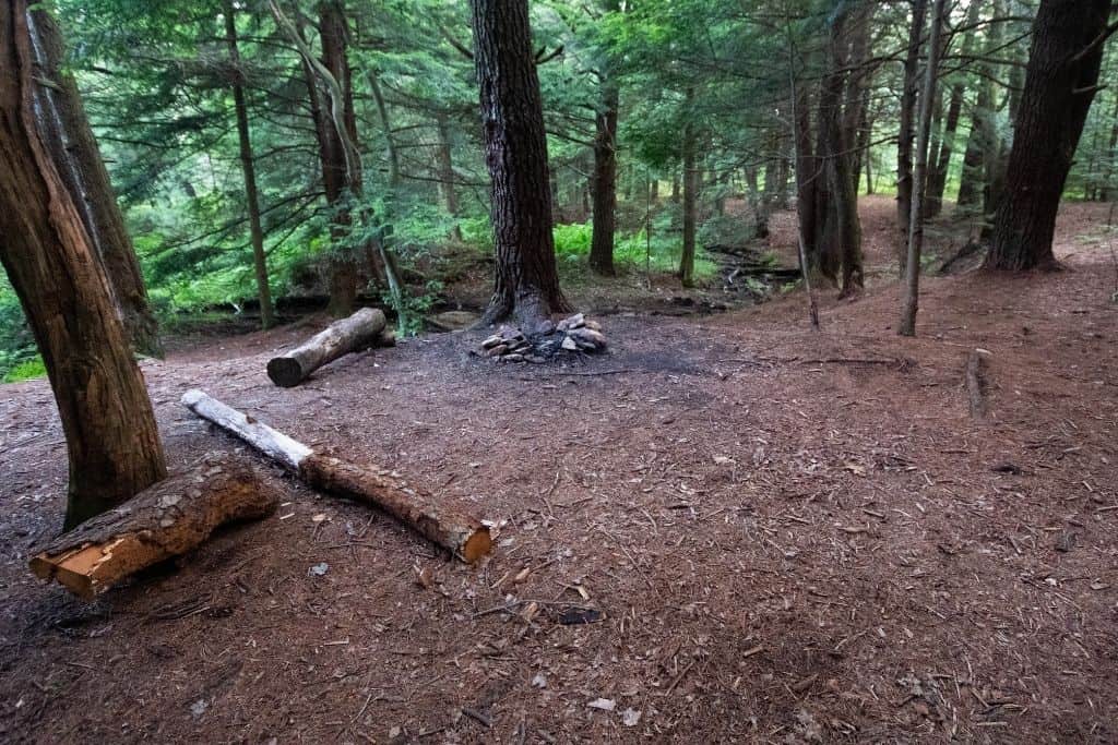
Campsites and Hiking along the Trail
There are plenty of campsites along the trail. Most are located near the best sources to refill your water, making it convenient to cook a hot dinner or begin your day with a full water bottle or bladder.

On our most recent trip around the AFT, we began on the eastern side of the loop at the parking area known as the Tram Road lot on route 504 and headed counterclockwise.
Here is the main pro and con of taking this route: Pro : Saving most of the beautiful vistas for the end kept us motivated Con : The 2 hardest sections of the trail were crossed while we were hiking tired, at the end of the first day, and the last few hours of our journey.
Typically, two campsites on the trail are no more than 5 miles apart, with many being much, much closer together than that. This is not an all-inclusive list, either.
We love our NatureHike Cloud backpacking tent for these types of trips. It is so easy to set up and tear down. The rainfly works extremely well to keep you dry, even in a downpour, and repel wind. On beautiful summer nights, leave the rainfly off to enjoy the fresh air and gaze up at the stars through the completely mesh top.

Anyway, here are the approximate distances to the campsite clusters from the route 504 trailhead, known as the Tram Road lot, so that you may plan appropriately depending on your abilities.
The easiest way to find the commonly used campsites is by looking for rustic rock circle fire rings just off the trail. You’ll know them when you see them.
The first campsites will come around between miles 3-5 along Rock Run. You’ll be able to find 4-5 campsites in this 2-mile stretch.

Near miles 8-9, a couple of campsites can be found on the left side of the trail along Benner Run.
Around mile 9.5, you’ll pass by a small cabin nestled in the woods and cross the Black Moshannon Creek on a small footbridge. Initially, you’ll see a great campsite with tons of room right across the footbridge, on the opposite bank from the cabin. If this one is already occupied and you prefer to have your own space, continue along Black Moshannon Creek, and over the next mile or so, you’ll find a couple more options.

At just over 10 miles, you should find a trail mailbox register near the junction with the Shingle Mill Trail, leading to Black Moshannon State Park. There are numerous campsites along this stretch before the state park boundary if you’re still looking for somewhere to turn in for the night.
The next campsites will require a little more of a hike, and you’ll reach them near miles 14-16. These are found on the difficult stretch traveling along the “red Mo,” so you will need to scope out the water situation a little more closely if this is where you stop to spend the night.
Around mile 17, you’ll cross the small country road, Casanova Road. There is a very short stretch of road walking here.
After crossing the road, you’ll head down along the stretch of trail weaving along Six Mile Run. There are multiple campsites along this stretch of trail, nestled under tall trees and among patches of rhododendrons. The large campsites here can accommodate multiple tents and are right along Six Mile Run for water.

We settled in at one of these campsites for night #1 of our trip and estimate we hiked around 18 miles on day #1.
One thing to note regarding these campsites along Six Mile Run : Six Mile Run Road is just on the other side of the creek, on the hillside. While you cannot really see the road from the campsites, if cars pass along the gravel country road, you will be able to hear, and possibly see the vehicles. If this will hinder your hiking experience along the trail, we wouldn’t recommend planning to stay at these campsites.
Continuing along the trail, you’ll come to the west Route 504 crossing around mile 20. As you cross the road, it will seem like you are trespassing on private property heading towards a cabin on their driveway, but you’ll stay to the left and head back into the woods along the creek, then up the hillside.

The trail eases off and you’ll pass through some of the easier, more gentle sections. Camping is sparse in this stretch, and you won’t find another one until just before reaching Shields Dam Road, around mile 23. This would be a campsite we’d only recommend in a pinch, though. There are much better ones along the trail.
When you reach Shields Dam Road, take a right and walk up to the T in the road, where it meets Six Mile Run Road. You’ll find the trail continues into the woods across Six Mile Run Road. This section we found just a little confusing, as what is labeled Clay Mine Road on the map could be mistaken for a trail.
Around mile 27, cross over Horse Hollow Road and through Wolf Rocks.

After Wolf Rocks, the trail dips down into the Hemlocks along another stream, and there are beautiful campsites around mile 28.
Next comes a long stretch without great camping that heads towards Black Moshannon State Park. There is a stretch of road walking on a dirt/gravel road just before the state park, where you will exit the woods and continue right on the gravel road, past a cabin on your left, and across a bridge/section with a guard rail. The trail will continue on your left about 100 yards past the guard rails.
This marks the 3 miles or so stretch through the state park. This section can be quite wet and muddy, even in the driest of times. Boardwalks have been installed over some sections of the marsh, but you still may get wet or muddy feet. No camping is permitted along the trail in the state park.
When you cross over Julian Pike, a paved road, around mile 35, this marks your exit from Black Moshannon State Park. You’ll notice that there are trail post markers with distances back to route 504 on this section. It feels kind of like a countdown , a welcome sight.
As you continue, you’ll see the Smays Run Trail intersection, with the Underwood Road Parking lot just up the trail to the right. You’ll want to continue straight.
Head through this easy section, and you’ll also find a few beautiful campsites along Smays Run, nestled among the hemlocks after crossing a small wooden footbridge. This is where we spent night #2 on the trail, and we estimate that we covered another 18 or so miles on day #2.
After this stretch of trail through the hemlocks, prepare for a climb, where you will head towards the edge of the Allegheny Front. You’ll reach the first vista around mile 37, Ralphie’s Majestic Vista.
There will be a few more vistas over the next couple of miles. From the vistas to the crossing of 504, where you return back to your car, is probably the most difficult section of the trail, as it is very rocky and covers some steep climbs and drops.
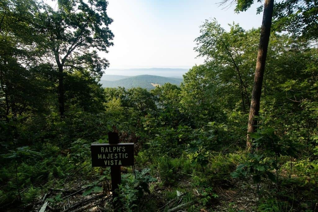
There are a few campsites along this section near the vistas, around mile 38 or so, but you’ll have to work a little harder to get water here. It would probably be a beautiful spot to watch a sunrise, though!
One last climb up a wide, grassy path, and you’ve made it back to your vehicle!
Celebrate a little! You’ve completed your hike on the AFT!
Splitting the AFT into Sections
It is possible to split up the Allegheny Front Trail into 2 sections, the east loop and the west loop. If you are looking for a shorter trip for backpacking beginners, or only have a short weekend to explore, consider splitting the trail up into two smaller loops for two separate occasions.
Both sections are about the same distance, landing you around 30-ish miles for each trip.
The eastern loop highlights include the vistas along the edge of the Allegheny Front and hiking through thickets of rhododendrons.
Through the western loop section, you’ll be treated to views of the “red” Moshannon Creek and along Six Mile Run, as well as a few rock formations at Wolf Rocks.
To make these loops possible, you’ll need to take the Moss Hanne Trail on the southern side, blazed in orange, and Shingle Mill Trail on the northern side, blazed in blue. These trails cut through Black Moshannon State Park, an easy spot to begin and end each of these loops.
Beware, no camping is permitted along these connector trails in the state park. The only camping permitted on Black Moshannon State Park grounds must be done in the designated campground.

Where else can you backpack in Pennsylvania?
Pennsylvania has a ton of options for overnight, multinight, and thru-hike-type trips!
For a shorter backpacking trip, head to the north-central part of the state, to the Pine Creek Gorge. Also known as the Pennsylvania Grand Canyon , the West Rim Trail is a beautiful trail that is 30 miles long. The trail skirts Colton Point State Park through the Tioga State Forest.
The Laurel Highlands Hiking Trail begins on the southern end in the town of Ohiopyle and Ohiopyle State Park . This trail is 70 miles long, and it travels east through the Laurel Highlands region towards Johnstown. This trail is particularly beautiful in the fall. It’s also known as part of the Potomac Heritage National Scenic Trail (PHT).
The Standing Stone Trail is not far away and runs from Cowans Gap State Park to Greenwood Furnace State Park , south of State College . This trail crosses central PA ridges and has numerous stunning vistas. It’s not an easy trail to hike. It’s 84 miles long now and spans 3 counties!
When it comes to long thru-hikes, trails such as the Appalachian Trail, North Country Scenic Trail, and the Midstate Trail all traverse the state in one way or another!
The AFT: Final Things to Know Before You Go
- We prefer to get out on the trail early in the morning. If you prefer to arrive a day ahead if time (like we did, arriving late on Friday night and setting out on the trail early Saturday morning), the established campground at Black Moshannon State Park has a nice tent camping loop with 9 sites. Its a great place to set up camp for a night, especially if you plan to arrive after dark.
- Sturdy, waterproof footwear is recommended for this trail, due to the rocky sections in the northwest and southeast. Blisters from wet boots and socks are no joke .
- Although hiking this trail in 2-3 days is doable, we think spending 3 nights out here would be perfect. There are so many beautiful stream-side campsites that we could have stopped and enjoyed a little longer. Take advantage of the beautiful settings!
- If you have to travel any distance home after your hike on the AFT and you’re visiting during the summer months, head back to the beach at Black Moshanon State Park. There is a bath house with showers by the beach where you can shower and change clothes before traveling.
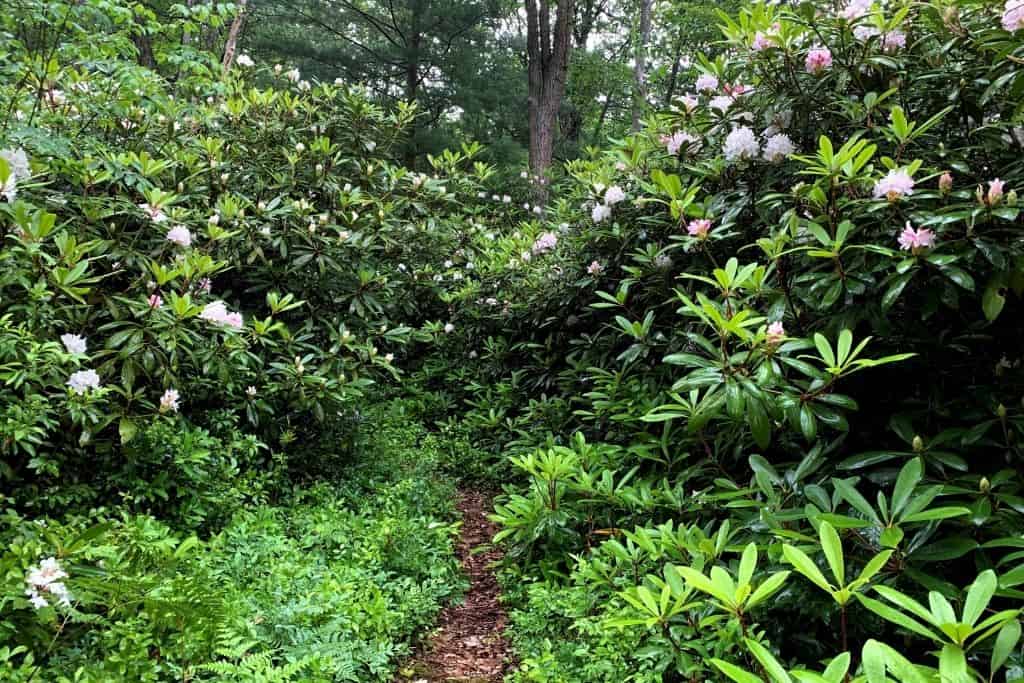
Should You Plan A Trip on the Allegheny Front Trail?
If you’ve ever had the urge to get out of your normal routine and experience life from a different perspective, hiking in nature is one great way to do it. Have you ever considered taking a backpacking trip?
The Allegheny Front Trail provides stunning vistas, beautiful waterway views, and is a great introduction trail for backpacking.
Anyone could backpack this trail with planning and preparation!
Is there anything else you need to know before heading out on your Allegheny Front Trail?

Samantha is the owner and author of PAonPause, a blog that helps travelers find the best outdoor travel experiences and highlights unique locations around the Great Lakes. When she isn't writing and creating content for the website, she's hiking and exploring with her husband and 2 rescue pups. She also enjoys a good craft beer, a summer ride in her Jeep with the top down, and discovering a new waterfall.
- United States
- Pennsylvania
- Backpacking
Pittsburgh, Pennsylvania
Looking for the best backpacking in Pittsburgh? We've got you covered with the top trails, trips, hiking, backpacking, camping and more around Pittsburgh. The detailed guides, photos, and reviews are all submitted by the Outbound community.
Top Backpacking Spots in and near Pittsburgh
Top activities.
- Photography
- Local Adventures
- Tours and trips
- Camping Nearby
- Outbound PRO Membership
- Add your property
Mobile Apps

© 2024 The Outbound Collective - Terms of Use - Privacy Policy
16 Trails in Pennsylvania That Will Leave You Breathless
When is the best time for happy travelers to get outdoors and enjoy the beauty of Pennsylvania? It’s a simple answer. With countless trails carving through the mountains and woodlands, every day is a perfect day to spend the day exploring the great outdoors, whether embarking on a new journey through a variety of terrain or a tried and tested trail near home. Whether you prefer to hike, bike, bird watch, or sightsee, here’s a sampling of some amazing trails guaranteed to leave you breathless.
1. Schuylkill River Trail
Philadelphia

The multi-use Schuylkill River Trail in southeastern PA will span almost 120 miles between Philadelphia and Frackville when completed. Currently, there are about 75 miles of completed sections, including a 30+ mile stretch from Philadelphia to Parkerford that’s perfect for a day-long hike or to explore over several days. In Hamburg, trail users can access a scenic seven-mile stretch to Auburn in Schuylkill County, while a 4.5-mile on-road section in Birdsboro includes old railroads offering beautiful views of the heritage area. The trail is a great way to enjoy the outdoors!
2. The Great Shamokin Path
Rural Valley

Tracing a section of the abandoned Rural Valley Railroad corridor, the Great Shamokin Path parallels the Cowanshannock Creek for 3.5 miles. Escape the heat of a warm summer’s day beneath the trail’s canopy and be on the lookout for a variety of animals, especially when on an early morning hike. Once a major trail that connected the two largest Native American towns in Pennsylvania, hikers can walk along the trail for beautiful views of western Pennsylvania.
3. Standing Stone Trail

The 84-mile scenic Standing Stone Trail , PA’s 2016 Trail of the Year , traverses central PA ridges and valleys from Cowans Gap State Park in the south to Rothrock State Forest’s Detweiler Natural Area and the Mid-State Trail in the north. More than 80 percent of the trail traverses state owned forest and PA Game Commission game lands. Near Mount Union, be sure to climb the popular Thousand Steps portion of the trail (or 1,036 steps to be exact!) that were used by silica quarry workers almost 100 years ago and offer great views of the mountains and surrounding area.
4. Pine Creek Rail Trail

Recognized by USA Today as one of the “10 Best Places to Take a Bike Tour,” the Pine Creek Rail Trail offers outdoor adventurers a spectacular, 62-mile journey through Pine Creek Gorge, better known as the “ Grand Canyon of Pennsylvania .” This historic path, once used to transport freight by train from Wellsboro to Williamsport, is also perfect for a relaxing hike with its scenic overlooks. The trail has a small grade, only around two percent, and runs mostly uphill. Even equestrians can join the fun with a section of the trail designed specifically for horses.
5. The Allegrippis Trails

Designed by mountain bikers and built by the International Mountain Bicycling Association, the stacked loops and 36 miles of single track trails that form Allegrippis Trails Info at Raystown Lake is a mountain bikers paradise! The almost endless combination of routes range from easy to moderate to most difficult and designed for outdoor enthusiasts of all biking levels. Be sure to take in the stunning views of Raystown Lake and local wildlife along the ride. At nearby Trough Creek State Park , park your bike and pull on some hiking boots to trek to Balanced Rock, a boulder that has hung on the side of a cliff for thousands of years — and Rainbow Falls, a waterfall along the footpath leading to Balanced Rock.
6. D&H Trail At Lehigh Gorge State Park

The varied trail surfaces and beautiful surroundings are what make the unique D&H Rail Trail a treat for any outdoor enthusiast. This 38-mile pathway traces the route of the former, historic Delaware and Hudson railroad, a small but vital rail line during the 1800s. The multi-use trail runs for several miles along the Lackawanna River and alternates between tree-lined sections and open stretches with vestiges of the region’s coal-mining heritage.
7. Heritage Rail Trail County Park
Seven Valleys

The 21.5-mile Heritage Rail Trail runs from the City of York to the Maryland border and includes the Howard Tunnel, four railroad bridges, New Freedom Train Station, and the Hanover Junction Train Station all listed on the National Register of Historic Places, as well as an operating tourism train along 10-miles of track. This ADA-accessible rail-to-trail was once a prime target for the Confederate Army prior to the Battle of Gettysburg. Known for its historic roots, the trail offers visitors a unique hiking experience.
8. Great Allegheny Passage

One of the nation’s most popular rail trails, the Great Allegheny Passage begins in Pittsburgh and crosses the border into Maryland, eventually ending in the nation’s capital. Complete from Pittsburgh to Cumberland, MD, the 150-mile Great Allegheny Passage® connects with the 184.5-mile C&O Canal Towpath to create a 333-mile non-motorized route between Pittsburgh and Washington, DC. — making it the longest unpaved bike path in the East Coast.
9. Montour Trail
The 63-mile multi-use Montour Trail system follows the route of the former Montour Railroad and Peters Creek Branch of the Pennsylvania Railroad between Coraopolis and Clairton in suburban Pittsburgh, making it one of the nation’s longest non-motorized suburban rail-trails. The trail connects with Pittsburgh International Airport, the Panhandle Trail, and the Great Allegheny Passage that stretches more than 330 miles from Pittsburgh to Washington, D.C.
10. Jakes Rocks Epic Mountain Bike Trail System

The Trails at Jakes Rocks is a system of stack-loop mountain biking trails constructed on the Allegheny National Forest. These professionally designed and constructed trails provide opportunities for all skill levels and ages winding through natural boulders and scenic forested landscapes and offering peaceful, beautiful outdoor recreation and exercise.
BREATHTAKING VIEWS:
11. laurel highlands hiking trail.
New Florence
Enjoy the picturesque Youghiogheny River and Laurel Mountain during a hike along the 70-mile Laurel Highlands Hiking Trail . The trail offers both challenging sections for seasoned backpackers with several steep, rugged areas, as well as reasonably easy, level sections for the casual hiker. A must-stop regardless of hiking prowess is Ohiopyle State Park with its breathtaking views and waterfalls to explore.
12. Allegheny National Forest
Marienville

The Allegheny National Forest , PA’s only designated national forest, celebrated its 100 th anniversary in 2023! The forest is an outdoor enthusiast’s wonderland with hiking and mountain biking trails, scenic views, and all sorts of terrain to explore along its more than 200 miles of trails. At 96.3 miles, the North Country National Scenic Trail is the longest trail in the forest and is one of three designated National Scenic Trails in PA. This trail takes visitors to vistas of the Allegheny Reservoir passing through rock outcroppings, open hardwoods, old growth forests, and stands of hemlock.
13. Pine Grove Furnace State Park

Nestled deep in Michaux State Forest near Chambersburg, Pine Grove Furnace State Park is the perfect spot for an outdoor adventure! Featuring four miles of looping trails, scenic overlooks, and Laurel and Fuller lakes, the park’s wooded, mountainous atmosphere attracts hikers of all skill levels. A portion of the Pole Steeple Trail , which also goes through Michaux State Forest , is a steep, 1.4 mile trail that ends at the Pole Steeple Overlook, a quartzite outcropping that overlooks the entire state park and the surrounding valleys.
14. Ricketts Glen State Park

A National Natural Landmark, Ricketts Glen State Park is best characterized by the Falls Trail System, a difficult, 7.2 mile trail that provides views of 22 gorgeous, named waterfalls. Ranging from 11 feet to the towering 94-foot Ganoga Falls, the waterfalls are each unique and provide tranquil resting stops along the rocky trail. Other trails traverse the park’s 13,193 acres, including the short Beach Trail that runs by the park’s swimming area and the Grand View Trial, which leads to the highest point on Red Rock Mountain. Each of the 26 miles of trails offers something different and are well worth the challenge.
15. Quehanna Trail

The Quehanna Trail is a 72.6-mile loop hiking trail in the Moshannon and Elk State Forests. The Trail passes through some of the most wild and beautiful country Pennsylvania has to offer. The main orange blazed trail begins on the western end at Parker Dam State Park . From Parker Dam the trail goes east into the Quehanna Wild Area toward Karthaus and Piper, then north toward Sinnemahoning and finally west through the Marion Brooks Natural Area back to Parker Dam.
BIRD WATCHING:
16. presque isle state park.

Presque Isle State Park offers 11 miles of hiking trails that will take you through scenic views of Pennsylvania’s only seashore. These sandy trails offer hikers a glimpse at the beautiful coastline of this National Natural Landmark, known as a favorite spot for migrating birds.
To discover more hiking experiences in PA, check out the visitPA website . Follow us on Facebook , Twitter , YouTube , Pinterest , and Instagram to stay up-to-date on even more great ideas and places to visit around our state. Don’t forget to sign up for our monthly Happy Thoughts e-newsletter so you never miss an update.
We use cookies to ensure that we give you the best experience on our website. If you continue to use our website, we will assume that you are happy to receive all cookies (and milk!) from visitPA.com. Learn more about cookie data in our Privacy Policy
5 of the Best Hikes in Pennsylvania
Get a locals take on the best day hiking trails in Pennsylvania with incredible views, waterfalls, and much more!

Hiking in Pennsylvania is both a pleasure and a pain. PA’s hiking trails offer great vistas, beautiful terrain, and weather that cooperates more often than not. But man, those rocks! Most hiking trails in Pennsylvania feature small, ankle-twisting rocks. So much so, that Appalachian Trail thru-hikers have dubbed the state “Rocksylvania.” But don’t let that discourage you. Get a good pair of boots, watch your footing, and enjoy the wonders of this gorgeous state. The best hikes in Pennsylvania are waiting for you!
I have lived and hiked in Pennsylvania all my life and it’s a hobby that I have now passed on to my two young daughters. Having explored most of the parks and trails in PA, I’ve listed five of my favorite hikes below.
Here are 5 of the best hikes in Pennsylvania and my personal favorites as a local.
As it goes in all of the destinations we share, please practice good trail etiquette and remember to Leave No Trace . This means packing out all of your garbage (including toilet paper), being respectful to others on busy trails, and following the established rules.
Map of the Best Hikes in Pennsylvania
The Best Hikes in Pennsylvania
1. the pinnacle trail, hawk mountain, hamburg, pa.
- Length: 9.1-mile loop
- Elevation Gain: 1,236 ft.
- Difficulty: Moderate
- Permit Required: None
- Pets: Allowed (on leash)
The Pinnacle Trail at Hawk Mountain is a perfect example of all the characteristics the best hikes in Pennsylvania have to offer: challenging, rewarding, and exceedingly beautiful. The Pinnacle Trail itself starts low in a valley next to a water reservoir. (Park your car in the lot next to the reservoir.) Tie your boots extra tight (remember those rocks we talked about!) and begin the 9-mile loop trail. As you ascend the side of Hawk Mountain you’ll see quaint, Amish-inspired farms in the distance and a patchwork of crops extending in all directions. If hiking in the summer, the plush treeline will obscure most of the outlooks, but once you reach a clearing you’ll be surprised by how high you’ve climbed in such a short time. (Your lungs won’t be surprised, though.)
Roughly one-third of the way up the trail you’ll arrive at Pulpit Rock, the hike’s first true vista. If it’s a nice day you may find a bit of a crowd gathered at this sharp outcropping of rocks. On other days, it might just be you and the views. At this point, if you proceed father down a short alternate trail your eyes will adjust to a strange sight: three or four massive telescopes populate the small clearing next to Pulpit Rock, making this the perfect place for stargazing. (Note: the telescopes are the property of an astrological society and are not open for public use. Either way, their placement on the mountain makes for a surreal scene.)
Once you take in the views at Pulpit Rock you’ll reconnect with the loop trail on your way to the trail’s namesake outlook, The Pinnacle. The trail then dips into a series of moderate switchbacks followed by more rocks. (Of course.) This section of the trail will require you to literally rock-hop from rock to rock, which makes the Pinnacle Trail a bad choice for dogs unless you can strap Fido to your back.
You’ll know you’re near the Pinnacle Outlook when you approach a large, conical-shaped pile of rocks, placed by hikers that have come before you. From there, you’ll rock-hop out roughly 100 yards to the Pinnacle Outlook. The view does not disappoint. Farmland extends for miles in all directions. If you’re lucky, a few hawks will be circling silently in the distance, effortlessly riding the wind. Far off, blue mountains frame the horizon, and cars twinkle noiselessly from a highway far below. This is a great spot to enjoy lunch and soak in the view.

Once you depart The Pinnacle you’ll double-back the way you came and reconnect with the loop again. About a mile into the loop, the trail splits. The right path is the Appalachian Trail and leads to New Jersey, and eventually, Mt. Katahdin, Maine. Instead, take the trail to the left, but not before noticing the grassy heliport located at the trail’s fork. The rest of the loop is easy in comparison to the strenuous uphill start. A gentle path (without rocks!) descends gradually next to a small creek on the right and thick rhododendron bushes on the left. You’ll eventually complete the loop and return to the parking lot next to the water reservoir.
2. Falls Trail, Ricketts Glen State Park, Benton, PA
- Length: 6.6-mile loop
- Elevation Gain: 1,010 ft.
Frequently cited as one of the best hikes in the United States and definitely one of the best hikes in Pennsylvania, Falls Trail at Ricketts Glen State Park is an absolute gem. Boasting 21 waterfalls, this 6.6-mile loop trail is a photographer’s dream.

Enter Ricketts Glen State Park’s main entrance and follow signs to the Falls Trail parking lot and trailhead. The hike is mostly a straight-up-and-down affair. Trail maintenance has done a wonderful job placing rocks like stepping stones, which allows easy access to the views without stressing about taking a major spill. (Although, be sure to watch your footing in the rain as the rocks are prone to getting slippery.)
I enjoy this hike best in the summer. You’re allowed to wade out into the streams and stand under the waterfalls. Having a 94-foot fall (the park’s biggest) crash over your head is a mystical experience sure to be the highlight of your trip. Take your time and enjoy each waterfall. The beauty of Pennsylvania is on full display here.
Once you reach the bottom of your descent, turn around and begin the equally enjoyable hike up. After a summer hike, be sure to cool off in the sparkling waters of Lake Jean located near the park’s main office. On-site camping is available to extend your stay. And with so much to see and do at Ricketts Glen, one day might not be enough.
3. Canyon Vista Trail, Worlds End State Park, Forksville, PA
- Length: 3.9-mile loop
- Elevation Gain: 754 ft.
Located roughly 45 minutes west of Falls Trail, Worlds End State Park is quieter and less frequented than Ricketts Glen State Park, but no less stunning which is why it makes this list of the best hikes in Pennsylvania. I hiked and camped there this past summer with my family for the first time and was very impressed by the clearly marked trails and amazing outlooks.
Worlds End features not one trail, but rather a series of trails that criss-cross the park and is now one of my favorite Pennsylvania hiking spots. My family and I completed the Canyon Vista Trail, a 3.9-mile loop trail that conveniently starts in the park’s campground. (It should be noted that the campground and facilities were immaculate.)
The first thing you’ll notice is the lack of crowds at Worlds End. For those of you that like to be alone with your thoughts when you’re out in nature, this is the park for you. The Canyon Vista Trail is another classic best hike in Pennsylvania: narrow, and then suddenly expansive. Gentle, and then quickly demanding. The rewards are plentiful here, including the Canyon Vista Outlook, the park’s main prize and signature view. The Canyon Vista Outlook boasts the dramatic meeting point of two converging mountains and showcases the best of the area known to locals as the Pennsylvania Wilds.

No trip to Worlds End State Park would be complete without watching the sunset from the High Knob Outlook, located a short drive from the park’s main office. End your night with some local fare from one of the many charming restaurants that surround the park. Sit back and relax knowing that you’ve just experienced the best of Worlds End State Park, and some of the best hiking Pennsylvania has to offer.
4. Shades of Death Trail, Hickory Run State Park, Pocono Mountains, White Haven, PA
- Length: 2.2 miles
- Elevation Gain: 282 ft.
- Difficulty: Easy
- Pets: Allowed
Don’t let the name scare you. Shades of Death Trail is an easy 2.2 mile loop trail at the base of the Pocono Mountains. This hike features a well-marked path through a rhododendron grove and a beautiful waterfall near the trailhead. This hike is popular and can get crowded early, so plan accordingly. While at Hickory Run State Park be sure to check out the surreal boulder field, one of the largest on the east coast.

5. Mount Joy Trail to Mount Misery Trail Loop, Valley Forge National Park, King of Prussia, PA
- Length: 3.8 miles
- Elevation Gain: 718 ft.
- Pets: Allowed on leash
Valley Forge National Park is a multi-use park located just outside of Philadelphia. The park is a big draw for Revolutionary War history buffs, as Valley Forge marks the spot where George Washington and the Continental Army spent a brutal winter encampment in 1777-1778. The 3.8-mile Mount Joy to Mount Misery Loop Trail provides hikers with adequate elevation changes and scenic views of the rolling green hills that surround Philadelphia. Start your hike from the Yellow Springs Trail parking lot and break a nice sweat while letting your mind step back in time.

For more hiking trails in Pennsylvania, check out this article on the Visit PA website .
Have you been hiking in this region? What do you think are the best hikes in Pennsylvania ? Let us know in the comments below! For more day hikes in the US, be sure to visit our hiking homepage on Bearfoot Theory

Brian Francis Smith is an educator, author, podcaster, husband, and father of two middle school-aged daughters. He teaches Project Based Learning at a public high school outside of Philadelphia. When not teaching, Brian can be found hiking the rocky trails of Pennsylvania with his family and dog Lucy or enjoying a bad horror movie. You can read more of his work at brianfrancissmith.com.
Leave a Reply Cancel reply
Your email address will not be published. Required fields are marked *
Save my name, email, and website in this browser for the next time I comment.
Hey. Looking for a 35 mile backpacking trip. Late June timing. [email protected]
Hi Jim, unfortunately we haven’t been backpacking in Pennsylvania yet. Best of luck on your search!
The Best Hiking Trails in Pennsylvania
Pennsylvania is so much more than historical cities and battlefields. The hiking trails in PA are the best way to explore Pennsylvania’s epic landscape!

Pennsylvania is a hub of American history, but many travelers underestimate the sheer beauty of its landscapes. Pennsylvania is a stunner, and it’s best explored on foot or by bike. The hiking trails in PA are numerous and fantastic, winding through dense forests, over rolling hills, and alongside cascading waterfalls. Whether you’re chasing mountain biking adrenaline, looking for rare birds, or want to do some leaf-peeping—winter, summer, spring, or fall—there’s a Pennsylvania trail waiting for you!
Explore Pennsylvania with Let’s Roam!
The Keystone State has a revered position in our nation’s history. Its “keystone” cities and charming small towns are brimming with interesting monuments, stately architecture, important museums, and excellent tourist attractions. You can experience them all on our Pennsylvania scavenger hunts! We’ve created trivia-filled sightseeing hunts, wild bar crawls, and intriguing ghost hunts to help you experience PA to the fullest. Check out the full list of PA hunts and explore this epic state with us in your pocket!
Pennsylvania’s trail system is so extensive, it’s hard to narrow down the choices to 15! We’ve gathered some of the best and tried to include something for everyone, from purely scenic jaunts to routes laced with historic landmarks. Mileages, difficulty levels, and elevation gains are taken from All Trails when available. Whether you’re a mountain biker, day hiker, or avid trekker, there should be a hike on the list that tickles your fancy. Let’s roam!
1. Ricketts Glen Falls Loop Trail
Location of Trailhead: Rickett’s Glen State Park in Benton
Mileage: 6.3 miles (All Trails); 7.2 miles (state park website)
Elevation Gain: 1,036 feet
Difficulty: Moderate
Points of Interest: During the winter months, the trail is only open to ice climbers and properly prepared hikers. You must register with the park office and obtain a winter permit. Cell reception may be lacking.
The Falls Trail in Ricketts Glen State Park is one of the best waterfall hikes in Pennsylvania. While listed as moderate, the trail is not for the faint of heart. It can pose difficult challenges, especially in wet or cold conditions. There are rocky sections that get slippery and several segments of steep terrain. The effort is well-rewarded though. You’ll witness 21 waterfalls (some sources say 22, but who’s counting?) including the glorious Ganoga Falls, tumbling 94 feet in a mesmerizing cascade.
Ricketts Glen State Park is a National Natural Landmark, and it’s loaded with miles of trails. If you have the chance, take the weekend to camp in the area and explore a few of the trails traversing this beautiful park. It’s considered by many to be the pinnacle of Pennsylvania hiking.
2. Hawk Falls Trail
Location of Trailhead: Hickory Run State Park, Parking off Route 534, East of Albrightsville
Mileage: 1.2 miles
Elevation Gain: 134 feet
Difficulty: Easy
Type: Out & Back
Points of Interest: This is a very popular trail for local runners and dog walkers. Your pooch is welcome if on a leash. The trail can get slippery, so wear appropriate footwear.
Hawk Falls Trail is a very popular spot with both active locals and tourists, and it’s because you get a lot of bang for very little buck. The trail is appropriate for all skill levels, and easily accomplished by smaller children, but it ends with a twenty-five-foot waterfall! Hawk Falls is perfect for newbie hikers, those with injuries, or families with kiddos.
It might be best to avoid this trail on the weekends, as it gets overcrowded. Going early in the morning is probably your best bet if you want to have any room to enjoy the falls. The parking lot on 534 and the next closest one at Boulder Run Field tend to fill up by mid-morning on the weekends.
3. Mount Minsi Loop via the Appalachian Trail
Location of Trailhead: Delaware Water Gap National Recreational Area, Roseto
Mileage: 4.8 miles
Points of Interest: Tackle this one counterclockwise to avoid a rocky descent. Dogs are allowed on a leash. This is a popular area for birding, so bring your binoculars!
You’ll be summiting Mount Minsi on this almost five-mile journey. You’ll enjoy views of the Delaware River, Mount Tammany, and the surrounding Appalachians. There are several small waterfalls along the path as well. Parts of the trail are steep, and most of it is quite rocky, so make sure to wear sturdy shoes. Unlike some of the mountain trails, this summit is open year-round, so you’re free to tackle it any time. Bring some food, the two overlooks are great spots for refueling while you take in the view!
4. Shades of Death Trail
Location of Trailhead: Parking area near the historic chapel in Hickory Run State Park, Albrightsville
Mileage: 2.2 miles
Elevation Gain: 269 feet
Points of Interest: The trail can get slippery. There are rocky sections with tree roots as well. Like all trails in the Poconos, it gets very crowded on the weekends.
Contrary to its dreary name, Shades of Death is scenic from start to finish. This picturesque trail can be moderately challenging, mostly due to tripping hazards, so watch your feet. The trail features a few small waterfalls as you walk along a babbling stream. This is a great trail for kids or light-hearted adults as you can swim or rock slide in the river. There are a few fun rock scrambles, and the trail is rated as fun by most hikers. It’s the perfect combination of scenic beauty with the river, falls, and giant rhododendrons, and it has a little adventure thrown in too. That’s a winning combination in our book!
5. Top of the World
Location of Trailhead: Dunmore
Mileage: 4.2 miles
Elevation Gain: 741 feet
Points of Interest: This trail traverses private land. Please stay on the trail and respect the land. The trail is commonly used by 4x4s and quads. You may need to seek permission or pay a small fee to drive on the trails. Hikers stick to the right side and beware, as this trail is mostly for bikers and quad riders.
The Top of the World Trail is commonly listed as one of the best things to do in the Scranton, Pennsylvania area. We add it to the list for those who are looking for an adventure trail for mountain biking or riding ATVs. If you choose to hike, be prepared to share it with lots of loud machinery.
The hike begins with a trek through the Dunmore Pine Barrens before reaching the top. The trail is rocky and muddy in places, so sturdy footwear is advised. Stop for a while and enjoy a snack with an epic vista view. You will need a navigation app while hiking this trail. There are several interweaving tracks that crisscross one another, and the trail is not well marked, so it can be an adventure.
6. Appalachian Trail, Pinnacle Trail, Valley Rim, and Pulpit Rock
Location of Trailhead: State Game Lands 106, New Ringgold-Join the AT just north of Hamburg Reservoir Parking Lot
Mileage: 13.6 miles
Elevation Gain: 2,230 foot
Difficulty: Hard
Points of Interest: This trail is steep, rocky, and requires 2-3 creek crossings. Segments are not well-marked, and you’ll need navigation. Prepare appropriately.
While pretty difficult, this series of trails is one of the most scenic in Pennsylvania. The trail runs over ridges, across small creeks, and through dense wood. It also features two natural viewpoints with incredible panoramas. While the first three miles of the AT are well-marked with white blazes, from there it gets a little more tricky. The Valley Rim section is less traversed and not well marked. The turn to the ascent is easily missed, so you’ll need to consult All Trails or another hiking GPS during your trek. This trail is popular for backcountry camping and backpacking. It’s a fun trail, but it should not be taken on without proper preparation.
7. Laurel Highlands Trail
Location of Trailhead: Most hikers start at mile marker 70, near Seward. Laurel Highlands Trail Parking Lot is at the trailhead.
Mileage: 70 miles
Elevation Gain: 10,351 foot
Type: Point to Point
Points of Interest: Camping is restricted to official campgrounds and shelters, which require a small fee. Water is scarce, and many of the shelters are at least a mile off-trail.
While rated hard, this backpacking trail through Ohiopyle State Park is better maintained than our last one. It does require several steep ups and downs, but overall, it’s a fairly flat trail and is well-marked. The most difficult portions of the trail are the beginning and the end. Water is scarce, allocated to the shelters and official campgrounds.
On average, the trail takes close to 30 hours to complete. Most people choose a five-day, four-night itinerary. Ohiopyle has a few fun waterfalls to explore, and the trail is beautiful from start to finish. If you don’t have five days to spare, you can take an out and back from Ohiopyle to Laurel Ridge State Park. This 9.4-mile adventure includes dense state forests, hemlock groves, and meanders along several small streams. It’s a lovely introduction to the bigger beast.
8. Canyon Vista Trail
Location of Trailhead: Worlds End State Park-Parking area located just off Hwy 154, near the park amphitheater
Mileage: 3.9 miles
Elevation Gain: 780 foot
Points of Interest: This trail can be very “buggy” in April/May
This trail is tons of fun! A perfect trek for older kids, it offers some small bouldering and chances to swim in the river. It’s a very well-marked trail with blue blazes. You’ll enjoy fantastic views of Loyalsock Creek Gorge as well. Most hikers choose to conquer the trail counterclockwise, tackling the steepest ascent in the beginning, and then cruising on through. World End has a network of more than 20 miles of hiking trails, including the popular Loyalsock Trail.
9. Kinzua Bridge Trail
Location of Trailhead: Kinzua Bridge State There’s a large parking lot just off Viaduct Road next to the trailhead.
Elevation Gain: 311 foot
Points of Interest: Dogs are welcome on a leash.
1882, Kinzua Bridge, was struck by an F1 tornado in 2003. The remnants of twisted steel have been left in a jumbled and fascinating art piece created by nature. While it’s sad to see such a marvel in ruins, it gives you a new respect (or possibly fear) of the sheer power of Mother Nature, seeing the massive steel pillars, peeled apart and tossed along the hills like matchsticks. The hike offers beautiful views and an interesting historical element. Listed as moderate, the effort comes at the end, as the climb out is no joke.
10. Chickies Rock Overlook Trail
Location of Trailhead: Chickies Rock County Park, near Columbia- Parking area at the trailhead, just off Hwy 441.
Mileage: 1 mile
Elevation Gain: 144 foot
Points of Interest: Easy day trip from Lancaster, York, or Philadelphia
This one is easy peasy, but it gives a big bang for the buck with Susquehanna River views escorting you most of the way. There are unmarked side trails traversing the area if you want to add a little more adventure to your stroll. It’s a great place to get out and stretch your legs a bit on your Pennsylvania road trip!
11. Thousand Steps Trail
Location of Trailhead: State Game Land Number 112- Parking area on Hwy 22, just past the trailhead.
Mileage: 1.5 miles
Elevation Gain: 843
Points of Interest: Requires traversing 1,036 steps. Dogs are welcome on a leash. There are some geocaches on this trail.
This Central Pennsylvania Trail is a short segment of the much longer and popular backpacking route, Standing Stone Trail. Standing Stone spans the ridges from Cowans Gap State Park in the South of the state to the Mid-State Trail and Detweiler Natural Area in the north. The Thousand Step Portion is difficult, but one of the most scenic sections of the trail. The set of stairs was installed by local quarry workers on Mount Union, and it offers excellent views of the surrounding mountains. This hike is strenuous! Bring water. Go early in the morning to avoid the heat. Take your time and enjoy rest breaks. It’s a difficult climb, but the views are A+.
12. Pine Creek Rail Trail
Location of Trailhead: Tiadaghton State Forest near Wellsboro
Mileage: 61.6 miles
Elevation Gain: 1,102 foot
Points of Interest: This trail is used by hikers, bikers, and horseback riders!
This award-winning biker trail is an almost 62-mile adventure through Pine Creek Gorge, aka, “The Grand Canyon of Pennsylvania.” The trail has many scenic overlooks and follows a historic cargo freight path from Wellsboro to Williamsport. The trail is well-marked and consists of hard-packed limestone gravel. While it’s a nice hiking trail, remember that it’s primarily used by bikers and equestrians, so be prepared to share the trail with faster hiking buddies. There are definitely more scenic trails for hikers in the area, but if you get your kicks on the bike, this is one of the best!
13. The Allegrippis Trails
Location of Trailhead: Raystown Lake National Recreation Area- Allegrippis Trails Parking Lot
Mileage: Varies by trail
Elevation Gain: Varies
Points of Interest: Predominately mountain biking trails
Constructed by the International Mountain Bicycling Association, the Allegrippis Trails are a network of stacked loops, consisting of 36 miles of single track. Ray’s Revenge is 20.1 miles of well-marked bike trail, while the Old Logger’s Trail is a five-mile trek more often used by hikers. You get good views of the lake along the way, and the area is a prime spot to see wildlife. Whether you’re hiking or biking, you may want to take the detour past Rainbow Falls to Balanced Rock, an interesting boulder formation that has been clinging to life on the side of a cliff for millennia.
14. Great Allegheny Passage
Location of Trailhead: Point State Park, Pittsburgh
Mileage: 150.2 miles
Elevation Gain: 7,447 foot
Points of Interest: Most of this trail is wheelchair accessible with a grade of less than 5%.
The Great Allegheny Passage is one of the most popular rail-trails in the United States. Beginning in Point State Park in the heart of Pittsburgh, the trail traverses Southwest Pennsylvania, ending in Cumberland, Maryland. If you still haven’t had enough, you can join the 185-mile C&O Canal path that treks all the way to Washington, DC. This conglomeration of paths is the longest non-motorized path on the East Coast.
The Allegheny Passage takes on average 50 hours to complete. Birding, camping, and fishing are popular all along the route. The trail runs along an abandoned railway track and consists mostly of asphalt and crushed limestone. Bikers are the primary users of this trail, due to its length, but hikers are welcome!
15. Mount Davis Highpoint Trail
Location: Mount Davis Pennsylvania Highpoint Trailhead, Meyersdale
Mileage: 2 miles
Points of Interest: Dogs are allowed on a leash.
This is one of our favorite winter hiking trails in Pennsylvania when you just want an easy stroll. The trail leads to a 50-foot observation tower with a gorgeous view of the surrounding area, especially when it’s covered in snow. The trail is nothing special until you reach the observation tower. It can also get very muddy, so bring waterproof footwear. The trail to the tower and back is approximately two miles, however, the formal trail keeps going if you have more energy. The total out and back is 5.4 miles. If you’re looking for an easy stroll through the snow with a sweeping view, then this is your perfect trail.
Closing Thoughts
Hiking trails in Pennsylvania are numerous and offer something for every kind of hiker or biker. From national forests to the Pennsylvania Grand Canyon, the landscape is a wonderland for those traversing it on foot. On your next trip to PA, pull yourselves away from the fabulous cities (and the cheesesteak) and spend some time on the trails! It’s the only way to truly get acquainted with the essence of Pennsylvania!
For more incredible sights in PA, check out “ The Best Things to Do in Philadelphia, Pennsylvania .”
Looking for a different kind of tourism? Step out on the dark side with a visit to “ The Most Haunted Places in Philadelphia .”
Don’t forget to download our scavenger hunt ap p so you have access to all our fun Pennsylvania tours and our Let’s Roam Local forum for tips and tricks on the best places to eat, drink, and play!
Frequently Asked Questions
Pennsylvania is prime hiking territory. Portions of the Appalachian Trail , Ricketts Glen Fall Loop Trail , and Mount Minsi Trail are all popular with Pennsylvania hikers.
While Pennsylvania has some hard hikes, there are a few that are fit for kids. Try the Hawk Falls Trail near Albrightsville or the Chickies Rock Overlook Trail near Lancaster .
Portions of the AT traverse Pennsylvania. The most popular hike is the Appalachian Trail, Pinnacle Trail, Valley Rim, and Pulpit Rock starting near Hamburg.
Along with great hiking trails , PA has some awesome rail trails for bikers. Check out the Allegrippis Trails in Raystown or The Great Allegheny Passage , starting in Pittsburgh .
The longest hiking trail in PA is the Mid-State Trail, running 327 miles from the border of Maryland to the border with New York. The most scenic portion is the Thousand Steps Trail near Mount Union.
Featured Products & Activities
Guided HikING
Take in a breath of fresh air, listen to the local wildlife, identify and taste local flora. Bring out your significant other, your family or your closest friends as you explore the trails and mountains of the Cumberland Valley and Lancaster parks. The guide will provide you with local stories, Environmental knowledge, equipment, and risk management to help make memories that will last a lifetime. Hiking trips take place within a 30-minute radius of Boiling Springs & Lancaster, PA. If you have a preferred hiking area, please make us aware upon booking.

Trips are guided and with your private group. Binoculars, hand ax, bird Watching
Learn the connection between you, your equipment and what nature has to offer. This adventure exposes participants to the basic skills of knife use, shelter building, navigation, water treatment, fire crafting, and more. Connecting with nature, learning skills, engaging in community, and having fun is what Bushcraft Basics is all about. The knowledge gained will make you more comfortable in the outdoors to identify, craft, and apply primitive wilderness techniques. Perfect for all ages, families, bachelorette/bachelor parties. Our team will design an experience around you. Come dressed for the weather.
Spoon Carving
Trips are guided and with your private group, and include materials.
Enjoy a three-hour spoon carving session and take home your own hand-carved wooden souvenir. Lose yourself in your work while connecting with yourself, your peers, and your environment. Trust us, three hours have never gone by so quickly. You will be provided with top-of-the-line Swedish carving knives designed specifically to meet the task. The guide will provide you with local stories, environmental knowledge, equipment, and risk management to help make memories that will last a lifetime. Spoon carving sessions are located within a 30-minute radius of Boiling Springs, PA.
Hiking Combos
Combine your hike with rappeling or climbing.
Combine your hike with either rock-climbing or rappelling along the ridge of the Appalachian Mountains. Come with your family, your significant other, friends, co-workers or leave everyone behind and enjoy that a day for yourself.
Combo hiking sessions, located at one of our many nearby climbing sites and trail systems, can be adjusted to any difficulty level to satisfy your enjoyment in a beginner-friendly environment. Location is within 45 minutes of Harrisburg, PA.
Want to Learn more? watch the Tutorials Below!
No, but we don’t allow kids under 12 to use knives or the ax.
Yes, absolutely. The cost would be the regular per person cost.
Except for extra caution with sharp edges, no. We keep the pocketknives closed and the ax covered when not being used.
We have multiple locations we use depending on what degree of difficult clients prefer.
If it’s the Spring, Summer or Fall, use layers to keep your body comfortable. If the winter, we’ll be using the same gear, but the same principle applies. Wear comfortable pants and a top that you can move easily in. Use a non-cotton base layer, preferably lightweight (cool days) or a layer made for wicking sweat and heat away
Wear eye protection and use Croakies to secure them. All wallets and phones get put into dry storage and travel with you.
Call for recommendations, if needed. Remember that wind adds windchill. Check this chart to estimate and dress accordingly: Wind Chill Calculator (noaa.gov)
Also, always check the weather for our local weather
Boiling Springs
We don’t suggest it. They do not have durable soles to protect you. We recommend light hiking boots.
Tips are not required but highly suggested. Your guide works very hard to make your time on the trail top notch. It’s customary to present a 10-20% tip to your guide at the conclusion of your trip.
Before Title
After title.
HQ - The Hotel Hershey, 100 Hotel Road, Outfitter Bldg,
Hershey, PA 17033
101 Front Street, Boiling Springs, PA 17007
Lancaster, now open
888-238-3975
Keep up with the latest! Join Our Newsletter.
The 6 best hikes in the Poconos to experience history, changing leaves and waterfalls

May 10, 2022 • 6 min read

There are hikes for all abilities and ages in the Poconos Mountains © SelectStock / Getty Images
Unfurling for almost 2400 sq miles, the Poconos Mountains in Pennsylvania is a vast outdoor playground of forest and rock that offer everything from skiing and snowshoeing to white-water rafting and biking across the calendar. It's also stuffed full of some incredible hikes – and most of the trails are quiet and peaceful.
With crashing waterfalls to discover, more than 150 lakes to circumnavigate or swim (yes, including the great Lake Wallenpaupack), and a host of wildlife to spot from bald eagles to black bears, the Poconos has it all. From leisurely saunters to expert-only treks, these are the best hikes in the Poconos Mountains.

Mount Minsi via the Appalachian Trail
Best hike for fall leaf-peeping 5 miles, 2-3 hours, moderate
The Appalachian Trail cuts across Pennsylvania for more than 229 miles, including some 45 miles through the Poconos. Starting at the village of Delaware Water Gap, this well-marked trail is open year-round. The route can be rocky at times and, depending on the weather, icy too. During the colder months, consider wearing crampons or Yaktrax, a winter traction device that fits over your hiking boots.
While traversing the five-mile loop, you’ll pass through enchanting rhododendron tunnels and moss-covered rocks as well as a number of waterfalls, including the Caledonia Creek cascades. From the summit of Mount Minsi – marked by a radio tower and rocky remnants of a fire tower – there are sweeping views of the Delaware River and New Jersey’s Mount Tammany .
Back down, Council Rock and Lookout Rock are both prime spots to take in the views, particularly leaf-peeping in the fall. Dogs are welcome as long as they’re on a leash.
Lock 31 Canal Trail
Best hike for exploring a historic towpath 1.6 miles, 1 hour, easy
In the 19th century, mule-pulled barges traversed the Delaware and Hudson Canal (the D&H Canal, as it’s known locally), delivering coal from Pennsylvania to New York City. Starting from Hawley, this out-and-back trail follows in their hoof steps, running along the canal’s grassy towpath and cutting through a 16-acre park that showcases the area’s natural beauty and rich, historic past.
Passing the remnants of the original canal lock and the Daniels' Farmhouse, a red timber home built in 1820 known as the Lock 31 House, this hike is popular with birdwatchers in the summer who look for bald eagles and other endemic species. Come winter, the trail lends itself to snowshoeing and cross-country skiing. Pack mosquito repellant in summer and early fall.

Dingmans Creek Trail
Best hike for families 1.4 miles, 45 minutes, easy
For a close-up of Pennsylvania’s second-tallest waterfall, take this breezy hike to the 130ft-high Dingmans Falls . Part of the George W. Childs Park in the Delaware Water Gap National Recreation Area , the trek begins at the Dingmans Falls Visitors Center (currently closed to the public) in Dingmans Ferry. Open May-November, the center offers guided walks and nature exhibits. The recreation area is open year-round.
The main trail is currently closed on weekdays for maintenance, but there is an alternative (non-wheelchair accessible) route that begins behind the visitor center. If you decide to hike the main trail on the weekends, show up early, as the parking lot fills quickly.
Just after the start of the main trail hike, you'll see Silverthread Falls, a slim, 80ft-high cascade on the right. Hikers will then pass a hemlock ravine and some rhododendron shrubs – visit in late summer when they’re in bloom. Most of the trail is on a wide boardwalk, making it accessible for wheelchairs and strollers.
Once you reach Dingmans Falls, there’s a staircase leading to the top for views of the upper falls and a rest area. The ease, accessibility, and view payoff make this a popular trail, so come on a weekday for fewer crowds.
Bushkill Falls Trail
Best hike for seeing waterfalls 1.8 miles, 2 hours, moderate
The Bushkill Falls are a series of eight waterfalls in a 300-acre wooded enclave hidden amongst the Poconos. Known as the Niagara Falls of Pennsylvania, there are four trails that lead to the cascades from the Bushkill Falls trailhead, each ranging in difficulty and duration – from the 15-minute, no-climb Green Trail to the more strenuous, nearly two-mile Red Trail.
The Main Falls can be seen from the primary observation deck, which is visible early in the trail, but to see all eight falls – including a close-up look at the beautiful Bridal Veil Falls – follow the Red Trail. You’ll need a couple of hours to traverse the boardwalk and climb some 1200 steps.
Popular with birdwatchers, it’s possible to see songbirds, owls, hawks, and eagles en route. An exhibition at the park’s entrance highlights the area’s endemic wildlife, which includes black bears. It costs $15 for adults to enter and $9 for children aged four to 10.

Promised Land Boundary Trail
Best hike for spotting flora and fauna 6.3 Miles, 3 hours, moderate
The 3,000-acre Promised Land State Park was once a hunting ground for the indigenous Lenape people. Today it is ribboned with more than 50 miles of hiking trails, including this rewarding hike along the 1800ft-high Pocono Plateau.
The trail is largely flat but rocky and strenuous at times. The flora, especially in the warmer months, makes for this a beautiful hike as rhododendron, mountain laurel, and wild blueberries complement a forest filled with hemlock, oak, and maple trees.
Starting at the north end of Promised Land Lake, popular for fishing and boating, the trail winds around the eastern side of the water, passing fern fields and bubbling creeks. Keep an eye out for white-tailed deer, black bears, wild turkeys, and bald eagles.
At the southern end of the lake, the Pickerel Point campground is a perfect place to pitch a tent and spend the night. The park is open year-round and dogs are welcome, as long as they’re on a leash.
Tobyhanna State Park Trail Loop
Best hike for summer swims 5 miles, 2-3 hours, easy
Anchored by the scenic, 170-acre Tobyhanna Lake, this state park is webbed with 10 miles of hiking trails that range in difficulty. For an easy hike that will pass a morning or afternoon, follow the trail loop that circumnavigates the lake and passes by bogs, evergreen forests, and a plethora of plant and animal life. In the spring, look out for Jefferson salamanders and wood frogs, which come to the bogs to breed.
The strong, well-maintained path makes the route good for trail runs and summertime biking as well as cross-country skiing and snowshoeing in the winter too. From Memorial Day (the last Monday of May) to mid-September, finish your hike at the sandy beach on the northeast side of the lake.
Here you'll find changing rooms, showers (accessible for a fee), and restrooms, as well as picnic tables. Pack your bathers for a swim.
You might also like: 8 inspiring artist homes in Northeast, Pennsylvania Historic taverns of the Eastern USA 8 cities where you’ll find culture and outdoor adventures
Explore related stories

Oct 14, 2021 • 5 min read
Virginia earns its reputation as a hiking destination with its extensive coastline, dozens of NPS and state parks, and 550 miles of the Appalachian Trail.

Apr 14, 2024 • 8 min read

Feb 29, 2024 • 4 min read

Sep 18, 2023 • 8 min read

Jul 13, 2022 • 6 min read

Jun 24, 2022 • 9 min read

Jun 23, 2022 • 9 min read

Jun 8, 2022 • 5 min read

Apr 13, 2022 • 5 min read

Mar 4, 2022 • 3 min read

These 6 Hiking Trips in PA Afford Beautiful Vistas and Waterfalls
It’s no secret that the Pocono Mountains are a scenic destination for outdoor recreation. Hiking trips in PA are the perfect place to view beautiful vistas and waterfalls along the way. If you’ve never visited the region before or you’re coming back for another getaway, let us help you find some of the best hiking trips in PA. We think these 6 hiking trips in PA offer the most breathtaking views.
1. Promised Land State Park
There are 50 miles of trails to explore at nearby Promised Land State Park . Trails vary in difficulty with options for everything from a relaxing stroll or a strenuous workout. The Bruce Lake Trail is one of the most popular. The five mile hike leads to a natural glacial lake. It’s a pristine body of water, undeveloped and only accessible on foot. Little Falls Trail is a fairly easy hike along a woodland trail. The one-mile loop trail follows along a babbling creek with numerous cascades and two footbridge crossings. Conservation Island Nature Trail is a pleasant one-mile walk with stunning lake views. The self-guided nature trail circles the island and is suitable for all ages and abilities. Visiting the park in all seasons will offer a completely different view each time. The blooms in the spring brighten the trail while the changing leaves in the fall offer a breathtaking view of a variety of colors.
2. Lacawac Sanctuary
Lacawac Sanctuary in Ledgedale, PA sits on 510 acres of protected and preserved land. The sanctuary offers a range of trails for beginners and skilled hikers. The park is also home to 52 acre Lake Lacawac, which is known as the southernmost unpolluted glacial lake in North America. The site is listed on the National Register of Historic Places and is a Registered National Natural Landmark. Hikers looking for an easy walk should check out The Historic Great Camp Trail, which is only one-mile and rated easy. The Big Lake Trail is 2.9 miles and rated more difficult to traverse.The sanctuary also boasts a mature second growth forest, two ponds, several wetlands and over a mile of unspoiled shoreline along Lake Wallenpaupack. Sites to tour also include the original lodge, an icehouse turned caretaker’s cottage, a carriage house and a visitors center.
3. Pocono Environmental Education Center
The Pocono Environmental Education Center, PEEC , in Dingmans Ferry, PA is home to six trails with varying terrain. The Tumbling Waters Trail is three-miles loop trail and can take two hours to complete. The hike is rated moderate to difficult and offers many points of interest. There’s an overlook of the Delaware River and Kittatinny Mountains in New Jersey as well as lush mixed growth forests and a pond. A series of switchbacks leads to the waterfall. Remnants of a farm are also visible along the trail. PEEC is located in Dingmans Ferry.The Two Ponds Trail is named for the two ponds seen along the 1.4-mile trail. The aptly named, Trail for Everyone, is the easiest and flattest walk offered at PEEC. Stroll through field and forest and along a pond on this trail that’s under a mile. There are numerous benches along the way to rest and observe wildlife.
4. Delaware Water Gap National Recreation Area
There are 67,000 acres of forested mountains and river valley within Delaware Water Gap National Recreation Area . The area straddles the Pennsylvania and New Jersey state lines with the Delaware River running through the center. It’s a perfect place for hikers who love to explore the trails year round. In spring the blossoms splash the trails with bright colors. Summer time trees provide plenty of shade. Autumn is beautiful with the changing fall foliage. And the winter season, though cold, offers views that no other season does because of the absence of the leaves in the trees. There are 100 miles of hiking trails, many which offer waterfall views. Some of the most popular include Dingman Falls and Raymondskill Falls. Hike to Buttermilk Falls to see the highest waterfall in New Jersey. For sweeping views, try the Cliff Trail or Milford Knob Hikes. The Mt. Tammany and Mt. Minsi hikes are also among the most popular in the park and offer dramatic views of Delaware Water Gap.
5. Shuman Point
Shuman Point boasts lovely views of Lake Wallenpaupack. This three-mile hike is narrow with one area of the trail that elevates to 80-feet above the lake. It’s part of a 250-acre plot in the Northeast corner that’s one of the last undeveloped areas along the lake. Much of the three-mile loop path traverses the lake shore. Take a break at a rocky beach outcrop and enjoy a picnic. Continue on a woodland path to see stone walls, remnants of the area’s farming past.The trail is great for all ages and skill levels.
6. Wallenpaupack Lake Trail
For the less adventurous hikers, the Wallenpaupack Lake Trail is 1.5 miles and boasts some of the best views of the lake. The trail is located next to the Wallenpaupack Environmental Learning Center. For the most part, the terrain is smooth and level. The vantage point along the dike offers expansive views. There are benches along the trail to take it all in. At the end of the trail are steps that lead down to an observation deck overlooking a wetland area which is overflow from Lake Wallenpaupack.
After a day spent hiking the trails of the Pocono Mountains, retreat back to The Settlers Inn for a restful night of sleep. Our Inn offers 23 spacious guest suites, each unique in their décor and offering a private bath. The Settlers Inn is home to a full-service farm to table restaurant and tavern. We’ve got some great upcoming events happening at the Inn to keep in mind when planning your getaway. Our Jazz on the Deck series continues through September 4 th . Or we’d love for you to join us for one of our holiday brunch celebrations including Labor Day or Columbus Day brunch. For reservation information, please give us a call at 570-226-2993.
- Search Please fill out this field.
- Manage Your Subscription
- Give a Gift Subscription
- Sweepstakes
- Travel Products
- Trends + Deals We Love
Hiking Gear Is Already on Sale at REI, Backcountry, and More Ahead of Summer — 53 Expert Picks Up to 75% Off
Shop top deals from Patagonia, Merrell, and The North Face, hand-picked by a professional gear outfitter.
:max_bytes(150000):strip_icc():format(webp)/Untitleddesign-2023-09-21T095521.004-d73c7b0845d6471783eaa848d8c9c3ea.jpg "top backpacking trips in pennsylvania")
Best REI Hiking Gear Deals
Best backcountry hiking gear deals, best amazon hiking gear deals, best dick’s sporting goods hiking gear deals, best zappos hiking gear deals.
If you click on links we provide, we may receive compensation.
Travel + Leisure / Tyler Roeland
I’ve been camping and hiking for almost two decades, and the trips I’ve taken in warmer months have been some of my absolute favorites. From cool early morning starts winding down into the Grand Canyon on Bright Angel Trail to tranquil days trekking about Tyresta National Park outside of Stockholm , I’ve covered a lot of ground over the years.
With all that mileage under my belt, plus two years of experience as a professional gear outfitter , I know a thing or two about the clothing and gear you need to have a successful excursion. Now that summer is almost here, outdoor retailers like REI, Amazon, and Dick’s Sporting Goods are offering major savings of up to 75 percent off on products perfect for your summer adventure. Whether your trails are across the ocean or closer to home, some essentials don’t change. Drawing from my years of experience and personal picks, I’ve put together a list including top brands like Osprey , Merrell , and Patagonia to make sure your summer hikes are perfect. Don’t wait — the summer won’t last forever, and neither will these deals!
As a lifelong backpacker, I find REI is always a reliable spot to pick up technical hiking gear. I prefer to wear long pants as long as I can into the summer for protection from the elements, so check out the Patagonia Women’s Happy Hike Studio Pants , marked down thirty percent, or the REI Co-op Men’s Trailmade Pants , a steal at just $35. Don’t forget to pack a base layer with UPF 30 sun protection, like the REI Co-op Merino 185 Long-sleeve Base Layer Top .
- Patagonia Women’s Happy Hike Studio Pants , $69 (originally $99)
- Patagonia Baggies Shorts , $41 (originally $59)
- Outdoor Research Women’s Argon T-Shirt , $40 (originally $55)
- REI Co-op Men’s Trailmade Pants , $35 (originally $70)
- prAna Men's Stretch Zion Slim Pants II , $47 (originally $95)
- Salomon Outpulse Mid Gore-Tex Women’s Hiking Boots , $80 (originally $160)
- TheTentLab The Deuce #2 UL Backcountry Trowel , $15 (originally $20)
- REI Co-op Trailmade Waterproof Women’s Hiking Boots , $42 (originally $140)
- REI Co-op Merino 185 Long-sleeve Base Layer Top , $56 (originally $80)
- Khumbu FX TA Trekking Poles , $59 (originally $150)
- Vuori Women's Vintage Ripstop Shorts , $34 (originally $68)
Salomon Outpulse Mid Gore-tex Women’s Hiking Boots
Backcountry
For epic day hikes this summer, Backcountry has you covered. Pair Osprey’s Sirrus 24L Backpack , a fantastic daypack with the brand’s cooling AirSpeed mesh back panel, with a light and protective Mountain Hardwear Women’s Crater Lake Long-Sleeve Hoodie , 50 percent off on Backcountry, for an unbeatable setup. And don’t forget to pick up a Patagonia pullover for chilly mornings and evenings on the trail while it’s up to 55 percent off.
- Patagonia Men’s Microdini 1/2-Zip Pullover , $71 (originally $125)
- Patagonia Women’s Maipo 7/8 Tight , $35 (originally $99)
- Osprey Packs Women’s Sirrus 24L Backpack , $135 (originally $180)
- The North Face Men’s Sprag 5-Pocket Pant , $56 (originally $80)
- The North Face Women’s Aphrodite 2.0 Capri Pant , $30 (originally $60)
- Prana Women’s Kanab Pant , $63 (originally $89)
- Black Diamond Men’s Alpenglow Hooded Shirt , $63 (originally $90)
- Black Diamond Women’s Notion SP Pant , $60 (originally $100)
- Mountain Hardwear Women’s Crater Lake Long-Sleeve Hoodie , $30 (originally $60)
- Outdoor Research Women’s Astro Short , $21 (originally $68)
Osprey Packs Sirrus 24L Backpack
As you may have noticed, sun protection is the name of the game on summer treks. Whether it’s at your local lakefront or on dusty desert trails, I can personally attest to how sun exposure can ruin a trip. Wide-brim hats, especially ones with neck coverings like the Sunday Afternoons Unisex Ultra-Adventure Hat (on sale for $32) are game-changing, as are breathable pants with UPF protection like the water-resistant (and best-selling) Baleaf Women's Hiking Pants , marked down to $37 and UPF sweat-wicking tops like this Baleaf UPF 50+ Hiking Shirt for 44 percent off.
- Baleaf Women's Hiking Pants , $37 (originally $56)
- Baleaf Women's UPF 50+ Sun Shirt , $20 (originally $36)
- Sunday Afternoons Unisex Ultra-Adventure Hat , $32 (originally $42)
- LifeStraw Personal Water Filter for Hiking, Camping, Travel , $15 (originally $20)
- Merrell Men's Moab 3 Hiking Shoe , $80 (originally $120)
- Klymit Single Traverse Hammock , $41 (originally $60)
- Adidas Women's Terrex AX3 Hiking Shoe , $64 (originally $80)
- Anker Portable Charger , $16 (originally $18)
- Asfixiado Women's Hiking Cargo Shorts , $8 (originally $16)
- Columbia Men's Tamiami Ii Ls Shirt, $49 (originally $55)
- Trail Buddy Collapsible Trekking Hiking Poles , $34 (originally $40)
- G4Free 10L/15L Packable Lightweight Hiking Backpack , $17 (originally $19)
Baleaf Women’s Hiking Pants
Trail buddy collapsible trekking hiking poles.
I love my long pants, but it’s hard to beat a pair of shorts you can take everywhere over the summer. My collection of Patagonia shorts grows every year, and I especially love their natural pairs like these Men's Lightweight All-Wear Hemp 7in Volley Shorts , a bargain at over 50 percent off. For active wear, sweat-wicking movement-friendly clothing like the Columbia Women's Pleasant Creek Stretch Short , on sale for $32, or Under Armour Men's Tech 2.0 Short Sleeve T-Shirt , a score at $12, are perfect for summer treks. No matter where you’re going, safety should always be a priority — I stash first-aid kids from Adventure Medical anywhere I can, and their Backpacker Medical Kit is a must-buy while it’s 50 percent off.
- Nike Women’s One High-Rise Leggings , $28 (originally $60)
- The North Face Women's Aphrodite Jogger Pants , $36 (originally $80)
- The North Face Women’s Arque Hike Dress , $46 (originally $110)
- Osprey Hikelite 18 Technical Pack , $66 (originally $120)
- Danner Men's Trail 2650 GTX Waterproof Hiking Shoes , $190 (originally $210)
- Patagonia Men's Lightweight All-Wear Hemp 7in Volley Shorts , $36 (originally $75)
- Patagonia Women’s 5-inch Baggies Shorts , $28 (originally $59)
- Under Armour Men's Tech 2.0 Short Sleeve T-Shirt , $12 (originally $25)
- Adventure Medical Kit The Backpacker Medical Kit , $24 (originally $48)
- Columbia Women's Pleasant Creek Stretch Short , $32 (originally $45)
Nike Women’s One High-Rise Leggings
It’s hard to understate how important a good pair of shoes can be, especially for adventure lovers who refuse to be slowed down by blisters and rugged terrain. It’s most obvious on long trails — I’ve talked to a number of Appalachian Trail thru-hikers who say the Altra Lone Peak 7 literally saved their feet, making them a serious deal at 34 percent off. I’ve loved the roomy toe-box in all the Altras I’ve worn, and for a more classic hiking shoe, I can also vouch for these sturdy Keen Women’s Targhee III Mid Waterproof , marked down 22 percent. Even for shorter jaunts, dialing in a great fit can make all the difference. I’ve put a ton of miles on my Chaco Women’s Z/Cloud X2 sandals, a score at 30 percent off, and their super-adjustable straps make it easy to tailor their fit for maximum comfort.
- Chaco Women’s Z/Cloud X2 , $70 (originally $100)
- Salomon Men’s Cross Hike Mid GTX 2 , $123 (originally $180)
- Columbia Women’s Newton Ridge Plus Waterproof Amped , $75 (originally $100)
- Hoka Men’s Hopara Sandals , $102 (originally $135)
- New Balance Men’s Fresh Foam X Hierro v7 , $96 (originally $140)
- Altra Men’s Lone Peak 7 , $99 (originally $150)
- Saucony Men’s Peregrine 13 , $98 (originally $140)
- KEEN Women’s Targhee III Mid Waterproof , $129 (originally $165)
- SOREL Women’s Lennox Hiker STKD Waterproof , $106 (originally $200)
- Salomon Women’s Quest 4 GTX , $165 (originally $230)
Chaco Women’s ZCloud Hiking Sandal
Love a great deal? Sign up for our T+L Recommends newsletter and we’ll send you our favorite travel products each week.
See More T+L Shopping Deals
:max_bytes(150000):strip_icc():format(webp)/roundup-fashion-item-under-50-tout-43eebfdde46942ddb93b1cbc0ac8c106.jpg "top backpacking trips in pennsylvania")
IMAGES
VIDEO
COMMENTS
3. West Rim Trail. Distance: 30.5 miles. Difficulty: Moderate. Approximate Time Frame: Two to three days. The Pennsylvania Grand Canyon. About the hike: The West Rim Trail is the most popular and most scenic backpacking route around Pine Creek Gorge, commonly referred to as "The Pennsylvania Grand Canyon.".
Pinchot Trail. 21.97 mi / 1913 ft gain. The Pinchot Trail, built by the Sierra Club's Northeast Pennsylvania Group and located in the southern corner of Lackawanna County, is an excellent warmup or beginner backpacking trail. The trail systems totals 22 miles but can be broken up by the North or South Loops.
Hop on the Appalachian Trail near this overlook and follow it past famed Hawk Mountain Sanctuary on one of the most beautiful stretches of trail in Pennsylvania and one of the best migration-viewing hikes anywhere. Contact: Appalachian Trail Conference, 304-535-6331; www.atconf.org. Our comprehensive guide to the best backpacking you can find ...
Pennsylvania is almost entirely covered by mountains and forest, and hiking in PA is always an adventure. The Appalachian Mountains, comprised of the Allegheny and Pocano ranges, cut through the center of the state. The 2,184-mile-long Appalachian National Scenic Trail, generally known as the Appalachian Trail, extends between Springer Mountain ...
Laurel Highlands Trail. One of the most popular backpacking trails in the state is the Laurel Highlands Trail. It is 70 miles point-to-point, so you'll need to arrange a shuttle. Located in western Pennsylvania, it follows Laurel Mountain through several state parks and forests.
Upstate PA's Loyalsock Trail in Worlds End State Park offers a peaceful immersion into the waterfalls and swimming holes along the Loyalsock Creek. The 60-mile point-to-point trail passes the remains of an old casino from the 19th-century logging boom (in addition to abandoned hotels and logging camps). Beginning backpackers might enjoy the ...
Here are the best multi-day backpacking trails in Pennsylvania: 1. Gerard Hiking Trail. Jason Pratt, CC BY 2.0, via Wikimedia Commons. Length: 33.9 mi / 54.5 km Type: Loop Difficulty: Hard Elevation Gain: 4996 ft / 1523 m Location: Oil Creek State Park Estimated Hiking Calorie Burn: 12 200 calories More Details: See on AllTrails. Explore a ...
For many hikers, day trips are preferred, and there are ample opportunities in almost all hiking locations to take on shorter segments. Ohiopyle State Park in the Laurel Highlands offers some of the best hiking near Pittsburgh (only 68 miles away) and in the entire state. With 79 miles of segmented trails through the park, it is a great option ...
To reserve a shelter, call Oil Creek State Park Office at (814) 676-5915. You will need to provide your name, address, telephone number, description of vehicles, license numbers, number in party, parking area, and direction of travel and date requested. Oil Creek has a ton of waterfalls, but they're relatively seasonal.
Pennsylvania has a ton of options for overnight, multinight, and thru-hike-type trips! For a shorter backpacking trip, head to the north-central part of the state, to the Pine Creek Gorge. Also known as the Pennsylvania Grand Canyon, the West Rim Trail is a beautiful trail that is 30 miles long. The trail skirts Colton Point State Park through ...
Pennsylvania. Pittsburgh. Backpacking; Pittsburgh, Pennsylvania. Looking for the best backpacking in Pittsburgh? We've got you covered with the top trails, trips, hiking, backpacking, camping and more around Pittsburgh. The detailed guides, photos, and reviews are all submitted by the Outbound community.
BIKE: 4. Pine Creek Rail Trail. Wellsboro. Pine Creek Rail Trail. Recognized by USA Today as one of the "10 Best Places to Take a Bike Tour," the Pine Creek Rail Trail offers outdoor adventurers a spectacular, 62-mile journey through Pine Creek Gorge, better known as the " Grand Canyon of Pennsylvania .".
2. Falls Trail, Ricketts Glen State Park, Benton, PA. Frequently cited as one of the best hikes in the United States and definitely one of the best hikes in Pennsylvania, Falls Trail at Ricketts Glen State Park is an absolute gem. Boasting 21 waterfalls, this 6.6-mile loop trail is a photographer's dream.
If you have the chance, take the weekend to camp in the area and explore a few of the trails traversing this beautiful park. It's considered by many to be the pinnacle of Pennsylvania hiking. 2. Hawk Falls Trail. Location of Trailhead: Hickory Run State Park, Parking off Route 534, East of Albrightsville.
The guide will provide you with local stories, Environmental knowledge, equipment, and risk management to help make memories that will last a lifetime. Hiking trips take place within a 30-minute radius of Boiling Springs & Lancaster, PA. If you have a preferred hiking area, please make us aware upon booking. Book Now.
Bushkill Falls Trail. Best hike for seeing waterfalls. 1.8 miles, 2 hours, moderate. The Bushkill Falls are a series of eight waterfalls in a 300-acre wooded enclave hidden amongst the Poconos. Known as the Niagara Falls of Pennsylvania, there are four trails that lead to the cascades from the Bushkill Falls trailhead, each ranging in ...
Hike to Buttermilk Falls to see the highest waterfall in New Jersey. For sweeping views, try the Cliff Trail or Milford Knob Hikes. The Mt. Tammany and Mt. Minsi hikes are also among the most popular in the park and offer dramatic views of Delaware Water Gap. 5. Shuman Point.
REI, Backcountry, and more popular outdoor gear retailers are slashing prices on hiking essentials ahead of summer 2024, with savings of up to 75 percent off. A professional gear outfitter reveals ...