

Weather On The Way
The most advanced road conditions app.
- Weather along your route
- Exactly at the time you will be driving through
- Pick the best time to leave
- Say NO to weather delays
- Know EVERYTHING about weather conditions at any point of your trip
A Road Trip Weather App
Weather on the Way is a new travel weather app that provides a detailed weather forecast for your driving route. Thanks to combining forecasting and navigation, you get weather conditions precisely at a time you will be driving through .

Perfect for road trips
Check the radar ahead.
For longer trips add waypoints and stops along the route. Set the stop duration and get the perfect forecast for the next day!
Pick a route, avoid a storm
No more unexpected delays.
Check alternative routes to make sure you have picked one with the best weather

CarPlay Support
Weather radar on your dashboard.
Track the weather forecast and precipitation while driving your car.

Full of details
Every step of the way.
Temperature, conditions, visibility, precipitation, wind speed, UV Index and more
Plan in advance
Up to 7 days before departure.
Swipe left and right to find the best time to leave.

Be aware of severe conditions
Stay safe on the road.
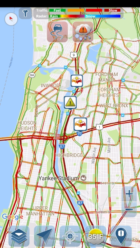
Weather alerts and radar along your driving route.
Check wind conditions
Speed, direction and gusts.
Driving a large vechicle like an RV or towing a trailer? Check for dangerous wind to avoid a risk of rollover.

"Literally saving my trip! [...] The app showed warnings where smoke and air quality were dangerous and I was able to pick a new route. So grateful!!"
"Why can’t google maps be like this. Finally, someone does it and they do it RIGHT. [...] Genius.
"Awesome! This app is ESSENTIAL for any road trips lasting more than an hour."
"It’s always frustrating that my other major map programs don’t show time zone changes or weather. Score on both counts! Nice."
FEATURED ON
See where it's raining - Live precipitation radar
Find the best time to leave - Interactive departure slider
NOAA alerts and advisories
Plan a road trip and set stop points
Ask Siri for Weather Ahead
Avoid blinding sun – Sunset and sunrise times
Know the weather at the destination – Should you take a raincoat or a swimsuit?
Easy to read forecast – Put your phone in a car mount
Dark Mode – Comfortable during long nightly drives
Privacy focused – No creepy tracking, no ads, no analytics. Does not store your location
Free PRO on first 5 trips
$4.99 monthly / $24.99 yearly after that.
Compare PRO features
Global – Works in 70+ countries.
Built by an independent developer
More to come!
Android version is coming soon
Sign up to get notified.
Arrive Safely to your destination every time with the best road trip weather planner app

"A very effective travel tool. Very helpful in navigating our film crews around the United States and making route changes based on weather conditions nationwide!"
- Ignite Movie Studios

The Best Road Trip Weather Planner App The Best Road Trip Weather Planner App
Get the weather forecast for your entire road trip.
View forecasts on the map to see if there's snow in that high mountain pass, or flash flooding across that lonely desert, all at the same time.
Weather Along Your Driving Route Weather Along Your Driving Route
Every forecast is adjusted to show the road weather precisely when you'll be driving through each location.
Live Doppler Radar and Traffic Cameras Live Doppler Radar and Traffic Cameras
View livehighway camera images for locations along your trip to see live weather conditions for yourself.
Travel Forecast Travel Forecast
Drag along the time slider to change your departure time and instantly see how the weather forecasts change at different times of day. Perfect for road trips with flexible schedules.
Have You Wondered About Finding the Best Time to Leave? Have You Wondered About Finding the Best Time to Leave?
Not sure what time to leave? The departure assistant will suggest an ideal time to start your trip. We'll find the ideal weather forecast to ensure a safe trip.
22% of all driving accidents are related to weather

What's New?
We now provide interactive highway maps for all major interstates in the US and Canada!
Trusted by All Kinds of Travelers for Their Road Trip Travel Needs Trusted by All Kinds of Travelers for Their Road Trip Travel Needs

Powered by Weather Route technology
Trusted & approved by the Innovative GEOINT Application Provider Program (IGAPP) for secure government devices.
We take privacy seriously. Your data is safe and will never be shared.
"The first app I open after I order a load. Easy steps, I can put in all my delivery addresses. I love it."
"I drive to Tennessee almost monthly. Outstanding reports. With GPS this is unbeatable."
- Dennis Ditinno
Check Weather Along Route Check Weather Along Route
- Parents taking families on trips between cities.
- Truckers and commercial crews driving for work.
- RVers and road trippers visiting a nation’s cities and parks.
- Motorcyclists looking for fun day rides.
- Professionals wishing to get the most from their business trips.
... and anyone with a passion for travel and a preference for careful and intelligent planning.
Our reports for traveling weather driving conditions will always keep you on course.
Download From Your App Store Download From Your App Store
"This works great for me as a truck driver to let me know what kind of weather I am heading in to and if I need to re-route. It's also very accurate."
- Preston Tanner
"Always accurate! Helps to determine what route I'll take on a road trip!"
- Dawn King
76% of weather-related fatalities involve wet pavement
What do we provide that sets our highway weather reports apart from our competitors what do we provide that sets our highway weather reports apart from our competitors, stay safe, informed, and on schedule stay safe, informed, and on schedule.

Highway Weather keeps you abreast of ...
- Moment-to-moment weather changes.
- The best time to hit the road.
- Every piece of relevant weather info at every stage of your trip!
Our technology streamlines your travel logistics by displaying real-time weather updates right alongside your trip route. It’s never been easier to plan your routes, maximize efficiency, and dodge the highway delays that come from sudden inclement weather.
We even customize the weather forecast for your needs. For example, if you're looking for trucking weather forecasts, we'll tailor the results to specially suit your vehicle, such as highlighting wind speed in our results.
Compare Routes and Find the Best Time to Drive Compare Routes and Find the Best Time to Drive

A good travel weather app recognizes that you’re looking to avoid hailstorms and flood warnings. A great app knows you’re also considering where you’ll spend the night, stop for lunch, drop off a shipment, or encounter the least amount of traffic. Highway Weather gives you the ability to add stops along the way and receive departure time recommendations that take into account the forecasts for the days ahead.
Our app allows users to observe and compare multiple route options, compare forecasts, and ensure that your trip itinerary meets all the needs for your road trips.

If you're planning your trip in advance or have a flexible departure time, use our interactive slider to adjust your departure time. Weather forecasts will update in real-time as you adjust the slider, giving you immediate feedback about weather conditions at different times in order to find the best conditions for travel.
Leverage a top-caliber weather app for travel planning that optimizes your trip and gives you as many clear sky days as possible!
Make Real-Time Adjustments Using Live Forecasts Make Real-Time Adjustments Using Live Forecasts

Highway Weather is the best weather app for traveling. Our interactive features provide ongoing updates for road weather information based on your specified arrival and departure times. You'll know when to stay on the road, when to get off the road, which road to take — and where to steer clear of debilitatingly bad weather. As you proceed, our app uses traffic cameras, forecast data, and weather radar to alert you to temperature, visibility, precipitation, wind speed, and many other relevant details.
Get to Your Destination — and Arrive Safely! Get to Your Destination — and Arrive Safely!
Highway Weather streamlines your travel plans by showing you all options for the best and most efficient routes. You will know exactly when and where you can expect to encounter weather that might pose a danger or inconvenience to your trip. We want to see you make it to your destination and return home with swiftness, comfort, and ease.
Since 2013, Highway Weather has continually developed and improved our features and design. With more than 100k global users, we’ve made a name for ourselves as one of the best travel weather apps available — complete with reliable, friendly customer support to answer and address any questions or concerns.
We provide free forecasts in addition to subscription features that proactively notify you of bad weather while you’re on the road driving. The app is even a preferred weather app for secured government devices who choose Highway Weather for its advanced privacy and security features.
Install Highway Weather now — and prepare to get back on the road!
What Do We Provide That Sets Our Highway Weather Reports Apart From Our From Competitors? What Do We Provide That Sets Our Highway Weather Reports Apart From Our From Competitors?
Arrive safely with our travel weather forecast arrive safely with our travel weather forecast.
Our technology streamlines your travel logistics by displaying real-time weather updates right inside your drive. It’s never been easier to plan your routes, maximize efficiency, and dodge the highway delays that come from sudden inclement weather.

Leverage the best weather app for travel planning that optimizes your trip and gives you as many clear-sky days as possible! And be on the lookout for severe weather alerts that are especially dangerous.

Highway Weather is the best weather app for traveling. Our interactive features provide ongoing updates for road weather information based on your specified arrival and departure times. You'll know when to stay on the road, when to get off the road, which road to take — and where to steer clear of debilitatingly bad weather. As you proceed, our app uses traffic cameras, forecast data, and weather radar to alert you to temperature, visibility, precipitation, wind speed, and other relevant details.
Highway Weather has existed since 2013, continually developing and iterating our features and design. With more than 100k global users, we’ve made a name for ourselves as one of the top apps of our kind — complete with reliable customer support to answer and address any questions or concerns.
Ready to Arrive Safely on Your Drive? Ready to Arrive Safely on Your Drive?
Download Highway Weather for free on Google Play or the App Store.
We Began Just Like You We Began Just Like You
Highway Weather was born of necessity.
It began in late 2012 with a simple problem: The app founder, Devan Stormont, was trying to visit family for the winter holidays. The drive was about 7 hours through "middle-of-nowhere" rural country with limited road and cell services. A series of rolling snowstorms were moving in a way that it wasn't clear whether the trip could be made without getting trapped in a storm. Existing apps and websites were not helpful in resolving the problem.
For the sake of safety, the trip was cancelled. Out of frustration, the first version of Highway Weather was created over the following weeks (and originally called Weather Route ).
At first, it was a hobby/personal app used to solve a personal problem and updates were made to fix personal annoyances. Over time, it became popularly adopted by many travelers and commercial users.
Since 2013, it's been our mission to ensure everyone can arrive at their destination safely.
Today, we do that by providing you the best road trip weather planner app on the market.
Best road trip apps
Take these apps with you when you hit the road

Hit the Road With These Top Android and iOS Apps
Whether it's trips back home or just a drive up to the mountains to enjoy some snow (and maybe a little skiing ), make sure your smartphone is riding shotgun. A number of Android and iOS apps can help with your next road trip by tackling everything from navigation to trip planning. Try out some of these apps the next time you hit the highway to make your next drive a hassle-free experience. ( Photo Credit: Syda Productions/Shutterstock )

Android Auto (Android: Free)
Designed to make it easier to use your apps and phone services while on the road, Android Auto used to be the province of cars with connected dashboard displays, but you can use Android Auto's simplified interface and voice commands straight from your phone's screen. Just mount your Android phone on a cradle or lock, and you're all set. Android Auto is designed to work with Google Maps, Play Music, and numerous other apps to help you navigate, control music playback, answer your phone or send off quick replies without becoming a distracted driver. With expanded Google Assistant controls, Android Auto just keeps getting better and better. A redesigned interface makes it easier to find the apps you want.

Waze (Android, iOS: Free)
Waze ( Android , iOS ) is a crowd-sourced traffic map and navigation app. Users can check out traffic conditions based on real-time information from other Waze users, complete with reports on road hazards, accidents, speed traps and more. You can also report any incidents you encounter. Best of all, Waze includes guided turn-by-turn navigation that take traffic conditions into account.

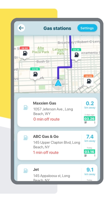
GasBuddy (Android, iOS: Free)
Long road trips mean you're going to need to fill up multiple times, so finding inexpensive gasoline and reliable filling stations is a must. Motorists in the U.S. and Canada stand to save some serious change with GasBuddy ( Android , iOS ), a mobile app that helps users track down the cheapest nearby gas station from their present location. As many of the prices are based on user reports, GasBuddy rewards users with points for reporting and updating a station's prices. Those points make you eligible for regular raffles of prizes, like free gas. Brave early adopters of electric vehicles can instead give Plugshare ( Android , iOS ) a try: it lets you look up and review nearby charging stations for your electric car.

TollSmart (Android, iOS: $2.99 monthly)
Road tolls can add an unexpected chunk to your travel costs. TollSmart ( Android , iOS ) is a neat trip-planning app that allows you to quickly look up the price of all toll bridges, roadways, and tunnels from start to destination. The app allows you to create profiles for a variety of vehicles from the family sedan all the way up to nine-axle vehicles to calculate vehicle-based toll rates. The app also includes support for a variety of transponder-based systems like E-ZPass. Users can automatically log in toll rates in the app's TollTracker system for easy expense report logging. An in-app purchase provides you the ability to compare tolls across multiple proposed routes.

TollGuru (Android, iOS: Free)
Another handy trip planning and toll assistant app is TollGuru ( Android , iOS ), which helps users calculate the cheapest and fastest toll routes, as well as estimates of fuel consumption based on your vehicle. Simply set your starting point and destination, and the app can help you figure out the fastest or cheapest route (integrating with other navigation apps), show you the applicable tolls, and even factor in tolls at departure time for peak and off-peak rates, factoring in payment options like cash or transponder tags. Users can save the make and model of their vehicle, edit MPG fuel efficiency rates, and even set fuel prices to estimate their costs. The app covers the USA, Canada, and India.

iExit (Android, iOS: Free)
Need to grab a bite to eat, withdraw some cash from an ATM, or catch some winks before the next leg of your road trip? iExit Interstate Exit Guide ( Android , iOS ) helps you plan your next pitstop, displaying handy pictographs of businesses and amenities in upcoming interstate exits. Users can search for specific businesses, display locations on an on-screen map, view gas prices, or find amenities like Wi-Fi, truck parking or campgrounds.

Drivvo (Android, iOS: Free)
Drivvo ( Android , iOS ) functions as a helpful car maintenance logbook, helping users log in details like fuel consumption, odometer readings, and any preventive maintenance measures and repairs. You can record your gas top-ups, expenses, and set reminders for repairs, servicing and regular maintenance. The app also includes a crowd-sourced feature for finding out the cheapest gas prices near you. The app is free and ad-supported, with a premium subscription removing advertising and providing extras like cloud synchronization across multiple devices and data export.

DailyRoads Voyager (Android)
DailyRoads Voyager turns your Android phone into a budget dashcam, allowing you to record video or photos of your trip in the event of an accident or any other unfortunate situation. You can define the video quality, user-defined storage size and cyclic storage (so that your internal memory never fills up). The app offers time-stamping and geotagging of your recordings, along with speed and elevation. The app is ad-supported, with a premium version that removes advertising.

MileIQ (Android, iOS: Free)
Not every drive is a personal trip or vacation. If you need to track your mileage for business trips and tax purposes, check out MileIQ ( Android , iOS ), an automatic mileage-tracking app that takes advantage of your smartphone's GPS and motion sensors to automatically log your trips, complete with map information, destinations, and purpose of trip. The app also provides exportable spreadsheets and reports so you can easily plug them in for your business records and tax purposes. The free tier allows you to log 40 free trips per month, with premium tiers (starting at $5.99 per month) offering unlimited trip logging.

PackPoint (Android, iOS: Free)
If you're going to be on the road and away from home for more than a few days, it helps to make sure that you're properly packed for the trip. PackPoint ( Android , iOS ) is a travel packing wizard that provides a checklist of travel essentials that you need to pack, depending on the nature of your trip. Users simply create a trip profile, with their destination, length of stay and purpose of travel. PackPoint then creates a customized packing and luggage checklist that takes into account whether you're traveling for business or pleasure, the type and amount of clothing to pack based on the weather forecast and other factors. The app also comes with premium features, such as TripIt integration for automatic packing list creation.

RoadTrippers (Android, iOS: Free)
Roadtrippers ( Android , iOS ) is another useful resource for road trip planning, helping users find everything from diners and dives to hotels, restaurants, national parks, roadside attractions and other scenic points of interest. Users can plan out trips in the app or its web portal, saving locations and stops into a trip plan which you can sync across multiple devices for easy reference.

Roadside America (iOS; $2.99)
When it comes to tourist traps, oddities, and roadside attractions, America is a country blessed. The Roadside America app is a rich database of the weird and the wonderful sites along the road, from muffler men to quirky museums, scenic vistas, and historical landmarks. Users can explore the map, search by geographic proximity, name, or by theme. Purchasing the app allows you to unlock one of 7 different US regions or Canada, with in-app purchases unlocking more regions or the entire package.

INRIX ParkMe (Android, iOS: Free)
Finding parking spaces in a strange city can be a hassle. Enter INRIX ParkMe ( Android , iOS ), which helps you search for the nearest and cheapest parking options with the help of your phone's location sensors. You can check out parking rates, including daily and monthly rates, set a parking timer so you'll never forget to refill the meter, find out parking space availability where provided by the building or garage and even reserve and pay for a parking slot with your phone.

SpotAngels (Android, iOS: Free)
Another option for on-demand car parking data is SpotAngels ( Android , iOS ), which provides crowd-sourced maps of free and paid parking locations. Included data also features lot rules, known fees, and other parameters that you can search on a map. Users can also book parking with partner parking garages and services when they can’t find a free slot. SpotAngels can remember your car’s parking spot using your car’s Bluetooth or phone sensors, and the app can remind you to move your car during street cleaning hours or whenever other parking restrictions are in place.

Spotify (Android, iOS: Free)
Road trips are an excuse to listen to some great road music. Spotify ( Android , iOS ) can relieve the tedium of the drive and set the mood with on-demand music, curated streams and playlists and a rich library of artists and bands to listen to. You'll want the $9.99-a-month premium subscription, which removes ads, and most importantly, allows you to download music for offline listening so you can skip mobile data charges.

Audible (Android, iOS: $14.95 monthly)
If audiobooks are more your thing, there's also Amazon's Audible audiobook service ( Android , iOS ) to consider. Featuring a library of more than 180,000 audiobooks, Audible is a powerhouse in the field, and the mobile app offers solid playback controls, complete with chapter and bookmark controls, multitasking support for background playback, and the ability to download audiobooks to your device for offline listening.

Pocket Casts (Android, iOS; $3.99)
What about taking your podcasts on the road? Try Pocket Casts ( Android , iOS ), which neatly combines style and function with an attractive design that showcases subscribed podcasts in tile format. Tap on a square to bring up an episode list and download options . A smart playlisting feature helps you sort and categorize your downloaded content for easy listening. The app also includes a variety of library organization features, support for streaming, and the option to download full episodes so that you don't have to use up your mobile data cap while on the road.

HotelTonight (Android, iOS: Free)
Ideally, you've got your accommodations and itinerary planned out on long road trips, but even the best laid plans can go wrong. If you suddenly need to look for last minute hotel rooms, HotelTonight ( Android , iOS ) is going to be a lifesaver, offering users last-minute discounts on vacancies and same night accommodations from top-rated hotels. Users can search by category and quality such as Basic, Hip or Luxe, view information on nearby hotels, and quickly book accommodations from within the app.

Yelp! (Android, iOS: Free)
If you're looking for a place to eat or shop in an unfamiliar town, it's hard to go wrong with Yelp ( Android , iOS ), which provides local reviews for more than 135 million restaurants and businesses worldwide. You can quickly check out reviews of nearby restaurants and diners, consult their menus, make a reservation or order delivery, or use the app to find nearby car services that you might need on the road, like a body shop or auto repair workshop.

Flush Toilet Finder (Android, iOS: Free)
The idea of an app for finding restrooms and toilets might, at first blush, seem silly, until you find yourself out on a road trip, about to enter what may or may not be an absolutely filthy restroom. Enter Flush Toilet Finder ( Android , iOS ), an app that uses your location sensors and checks its database of more than 200,000 public and paid toilets worldwide, showing you nearby toilets on a map, with information such as whether the toilet requires a fee or key or includes handicapped access. Neat features include the fact that Flush Toilet Finder functions even when offline; it can integrate with Google Maps to provide directions to a selected restroom.

Instagram Blend could surface reels for you and a friend
Apple Arcade April launches just revealed — including two Vision Pro games
Best Bluetooth Car Adapters
Most Popular
- 2 New ‘Deadpool and Wolverine’ trailer — this movie might just turn Marvel around
- 3 This 10000mAh power bank just crashed to $17 at Amazon — and it’s the best we’ve reviewed
- 4 The best show you haven't seen is finally coming back — here's when
- 5 The 3 best bed toppers to pair with the Saatva Classic mattress
- 2 This 10000mAh power bank just crashed to $17 at Amazon — and it’s the best we’ve reviewed
- 3 The best show you haven't seen is finally coming back — here's when
- 4 The 3 best bed toppers to pair with the Saatva Classic mattress
- 5 Epic Adidas sale from $9 at Amazon — here's the 11 deals I'd buy
Highway Weather 4+
Arrive safely, weather route.
- 4.4 • 335 Ratings
- Offers In-App Purchases
Screenshots
Description.
Arrive Safely Travel weather forecasts for your entire road trip at the time you will arrive. Weather alerts, radar, traffic cameras, and plan for rests. Family vacation? Long-haul trucking? Touring in an RV? Heading to a motorcycle rally? Whatever your passion, we want to ensure that you arrive safely. There's nothing like the uncertainty of knowing if weather will disrupt your trip. Instead of searching for weather forecasts city-by-city, get all the information you need all at the same time, in an easy to understand display. Free features for planning a trip: • Compare forecasts for your entire trip. • No limitations on trip length. • Get recommendations for the best time to start your trip. • Adjust your departure time instantly and see updated forecasts. • View live outdoor cameras for your trip. • Get severe weather alerts along your route. • Add rest stops to long trips. • Wind and precipitation levels also inform whether travel is safe. • Global weather forecasts, for all regions of the globe. All planning features are provided free of charge! For the hands-free active driving mode, a subscription is required. • Receive automatic updates while on the road. • See updates instantly in the app. • Get notifications when the app is running in the background. • More features currently in development! Subscription Details: • Length of subscription: 1 year (with 14-day free trial period) • Price of subscription: $14.99 / Year • Payment will be charged to iTunes Account at confirmation of purchase. • Account will be charged for renewal within 24-hours prior to the end of the current period. • Subscriptions may be managed by the user and auto-renewal may be turned off by going to the user's Account Settings after purchase. • Any unused portion of a free trial period, if offered, will be forfeited when the user cancels a subscription. Privacy policy & terms and conditions: https://www.weatherroute.io/privacy_policy.html
Version 6.119
This release is a maintenance update to update libraries packaged with the app.
Ratings and Reviews
335 Ratings
Most recent update FIXED MARJOR ISSUE which was in the prior update.
I used to use this app for planning road trips. However, now it's completely useless because with the most recent update all I get is a black screen after touching "Drive now" and/or "Plan ahead." Instead of making improvements which make big changes, it would be much wiser to fix bugs and add minor changes. Always remember: "if it works, DON'T fix it!" Edited Monday 1009 March 2020. I replied to developer with screenshots yesterday, Sunday afternoon. Just installed update an EVERYTHING IS WORKING AS IT WAS prior to previous update. Developer FIXED IN LESS THAN 20 HOURS! OUTSTANDING! Thank you very much for your quick response to the issue about "centering" were the "x" was not on the screen on my iPad Pro and iPad Mini. I changed my rating from 1 to 5 stars.
Developer Response ,
UPDATE: I haven't heard back from this user, but I've confirmed with a test device that the way the prompts are centered is the problem; a particular centering method works well on iPads and larger iPhones, but not on smaller devices. A new iOS release will be out shortly to fix this for new users. Old users can simply restart the app and they'll have the fix. ORIGINAL: Can you please email me at [email protected] with more details? This is the first report of a black screen and it definitely sounds like like a bug that needs to be fixed. In both cases, you should be seeing two different prompts that require closing. If you're not seeing those prompts, I'll need to fix that.
THe weather/navigation app to have
Planning for a 5 - 6 hour, multiple state motorcycle ride had me trying all the best reviewed apps in this category. I can’t say enough about how much better Highway Weather is in my opinion. Not only was I able to effectively choose a great route with better weather (someone in my party chose the “fast route” using another app and regretted it), but I experienced a subscription related issue and the response I received was so much faster than I expected and a fantastic interaction. If I could rate higher than 5 stars, I would!
Thanks so, so much for the kind words, Adam! :-) Safe travels, and enjoy a summer of motorcycle trips!
Was hopeful but….do not recommend…
For the last 14-years we have traveled from the West Coast to the Mid-South multiple times a year in two days. Initially we planned our trips using The Weather Channel. When they discontinued weather conditions for the US Interstates, planning a trip became more challenging. Sites like Road Now require too much interaction for each state and exit to determine weather conditions. So, when I located your website and mapped out our route along I-40, I was pleanstly surprised with the various filters one may use to receive the information needed. Based on the information provided, we planned our trip for yesterday and today. We are approximately 2-hours from our destination and this has not been a pleasant experience. The weather conditions we encountered were not predicted. In addition, I downloaded the App, thinking that we could monitor conditions easier on the road - Icould not have been more wrong! For over 200-miles, the app and website did not register our location or, if it did, the forecast information was not available. Even as we were deak]ling with the challenging weather, the App and website did not indicate what we were experiencing. Needless to say, the App and Website Bookmark will be deleted after completing this review. This appeared to have so much potential but from someone who has extensive experience with this route, this was an epic failure.
Hi, there. Firstly, I'm really, really sorry about the experience you've had! I'd strongly encourage you to reach out directly to us a [email protected] so we can open up a proper conversation and dig into the issues you've experienced with the app. I would like to convey that we source our weather data from highly reputable sources (e.g. NOAA). And, while these sources are typically very accurate, even the most-trusted sources cannot always account for rapid changes in conditions that deviate from what was previously predicted. Additionally, we'd very much like to learn more about the application not updating as you executed your route. This typically isn't something that should happen, but I will say that the app updating is dependent on whether or not your device has access to data (either WIFI or mobile data). Without data, Highway Weather will be unable to update the latest weather data and alerts or obtain your location. Again, we're really, really sorry about the sub-par experience you've had. We'd be honored if you would reach out to us via our Support channel to see if we can dive into your specific experience further and see if we can make things right. Thanks so much!
App Privacy
The developer, Weather Route , indicated that the app’s privacy practices may include handling of data as described below. For more information, see the developer’s privacy policy .
Data Not Linked to You
The following data may be collected but it is not linked to your identity:
- Diagnostics
Privacy practices may vary, for example, based on the features you use or your age. Learn More
Information
English, French, Italian, Portuguese, Spanish
- Subscription $2.99
- Annual Subscription $14.99
- Remove Ads $4.99
- Developer Website
- App Support
- Privacy Policy
You Might Also Like
Drive Weather: Road Conditions
Highway Weather, Travel, Road
Weather on the Way
Weather Road Conditions
MORECAST Weather App
Wind Compass

Highway Weather

About this app
Data safety.

Ratings and reviews

- Flag inappropriate

- Show review history

What's new
App support, similar apps.

- Search Please fill out this field.
- Manage Your Subscription
- Give a Gift Subscription
- Sweepstakes
- Travel Tips
- Mobile Apps
The Best Road Trip Apps That Help You Find Cheap Gas, Avoid Traffic, and More
Download these before you hit the highway.
Elizabeth Rhodes is a special projects editor at Travel + Leisure , covering everything from luxury hotels to theme parks to must-pack travel products. Originally from South Carolina, Elizabeth moved to New York City from London, where she started her career as a travel blogger and writer.
:max_bytes(150000):strip_icc():format(webp)/elizabeth-rhodes-25083778bc654f69b30ce8417affc82c.jpg "travel road conditions app")
Carmen MartÃnez Torrón/Getty Images
Technology has revolutionized the way we travel in countless ways. Paper maps and GPS navigation systems have been replaced by Google and Apple Maps, old-school CDs by music streaming services, and guidebooks by apps that can notify road-trippers of roadside attractions in real time. One thing is certain: the smartphone has made road trips infinitely easier and, arguably, cheaper.
Whether you need a digital road trip planner to map out your next journey or something to help you avoid traffic jams, here are 11 of the best road trip apps to download ahead of your next adventure.
Roadtrippers
Roadtrippers is one of the most practical and popular road trip planning apps out there. Maybe you want to see national parks or the quirkiest roadside attractions. Perhaps you want to stop for the night at an iconic or underrated hotel. You can plan your stops right in the app, adding up to three waypoints for free or 150 with a Roadtrippers Premium account. There are also Basic and Pro memberships that allot you 20 and 50 waypoints per trip, respectively. The higher-tier memberships allow you to collaborate with friends and family and use navigation. The app features lodging, sights, outdoorsy destinations, restaurants, activities, shopping, fuel, and more all around the U.S., Canada, Australia, and New Zealand.
The app is free, but you have to upgrade to a membership plan to enjoy all the bells and whistles. The Basic plan costs $40 a year, the Pro plan $50 a year, and the Premium $60 a year. It's available on iOS and Android .
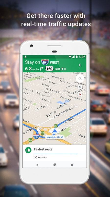
Google Maps
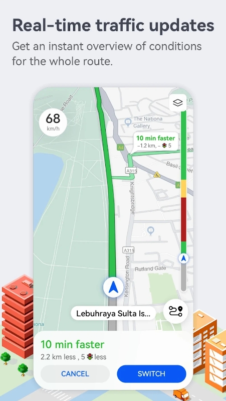
Every road-tripper needs a trusty navigation app in their arsenal, and Google Maps is consistently one of the most — if not the most — downloaded in the U.S. every year. Its dominance can be attributed to how comprehensive its data is, which allows it to generate the very best directions based on distance, road conditions, and traffic patterns.
Google Maps gives you route options and provides accurate estimates of how long it takes to get from A to B. Plus, you can plot several waypoints along your route — be it a mid-morning coffee stop or a hotel for overnighting (you can see reviews right in the app).
Google Maps is free and available on iOS and Android .
Waze is another one of the top navigation apps. With real-time updates that help you avoid traffic jams, construction, and more, it will have you navigating new cities and unfamiliar streets like a seasoned local. It's perhaps a little more proactive than Google Maps in changing up a route when problems arise, and that means Waze users should prepare for their drive to be a little unpredictable.
No one wants to spend hours sitting in traffic instead of exploring, so the fact that Waze collects data from other drivers to streamline the driving experience is a huge help. The app is free and available on iOS and Android .
Paying for fuel can eat up a good chunk of your road trip budget, but GasBuddy can save you a few bucks. The app crowdsources up-to-date fuel prices for more than 150,000 gas stations around the U.S. and Canada. The app also tells you how recent the submission is so you know whether it's outdated.
GasBuddy is not just helpful for finding cheap gas but also for finding gas stations in general (and parking), which can be difficult in foreign territory. The app is free and can be downloaded on iOS and Android . While using it, be a good road-tripper and submit gas prices you see as you travel.
Roadside America
Barry Winiker/Getty Images
The offbeat and kitschy roadside attractions you can find throughout the U.S. are often some of the most delightful parts of a road trip. The Roadside America app helps you find the most unique attractions worth stopping for, like the large sculpture of a cartoon mouse holding a cheese platter in Plain, Wisconsin — where else? — or the decidedly odd larger-than-life-sized three-way electrical plug that rests on a lawn in Philadelphia. The app features museums, murals, tours, quirky restaurants, and photo ops.
Roadside America costs $3 to download, which gets you access to one region in the app. You can purchase more regions for $2 or get access to all of the U.S. and Canada for an extra $7. The app is available only on iOS .
iExit Interstate Exit Guide
Knowing where to stop for road trip snacks, a drive-through latte, or a public restroom can be challenging with all the exit signs whizzing by at 70 mph, but iExit Interstate Exit Guide takes the guesswork out of it. The app will list which exits are coming up on your route, what's there, and what they offer — including food, lodging, fuel, and even hospitals. It pulls fuel prices from OPIS (the Oil Price Information Service) and displays Yelp reviews for businesses.
The app is free to download. Find it on both iOS and Android .
HotelTonight
Even if you've planned out all your stops ahead of time, you might find that you need to pull over for a night unexpectedly. Driving is tiring, and unplanned naps can be life-saving. HotelTonight can help you find accommodations in a pinch. The app offers day-of deals on unsold rooms, and the user-friendly interface means you can book a discounted room in minutes. There are well over 1,000 properties to choose from in cities all over the world, from Mexico City to Jakarta (in case you happen to take your road-tripping global).
It's free to download and available on iOS and Android .
If staying in a tucked-away A-frame cabin, a yurt, or a private guest house in someone's garden is more your travel style than bouncing between hotels, then Airbnb is the ticket. On the Airbnb app, you can search properties (millions in the U.S. alone) on a map and read reviews before you book, which you can do in advance or at the last minute.
The app features not just vacation homes but also activities, so if you're keen to experience a city like a local you can do so via a pottery class or a guided walking tour, for example.
The Airbnb app is free. You can download it on iOS or Android .
Patchareeporn Sakoolchai/Getty Images
Travelers who dream of camping out under the stars should download The Dyrt , a free app that helps you find tent, RV, and cabin sites across the U.S. One of the top camping apps on iOS and Android , it has more than a million registered users who submit reviews, pictures, and tips. On The Dyrt, you get real intel on campsites and a built-in community that makes camping on a road trip especially fun and safe. You can even book some of the campsites right on app.
The app is free, but there's a premium version for $36 a year that allows you to plan trips and search campsites while offline — convenient for remote regions.
What is a road trip without a perfect playlist? Whether you're keen to create a soundtrack of nostalgic singalongs, modern pop songs, or music inspired by your destination, you'll find even the most obscure tunes on Spotify , a catalog of more than 100 million tracks. When you tire of Taylor Swift, you can turn to podcasts or an audiobook to keep you company. Road trips are a great opportunity to delve into a docuseries like "Serial," an all-time favorite.
Spotify is free to download and listen to, but the ad breaks are annoying and streaming can chew through your phone data. A better option is to purchase a premium membership for $11 a month. It's ad-free and you can download music to listen to offline. The Spotify app is available on iOS and Android .
Electric vehicles are increasingly commonplace and great for more environmentally friendly road-tripping. The problem is often finding charging stations, as most EVs can go 100 to 300 miles before they need to be plugged in. PlugShare lists 700,000 charging stations across North America, Europe, and beyond. Users share their reviews of the stations, helping to guide EV drivers to the best, fastest, and most reliable charging spots.
PlugShare is free and available to download on iOS and Android .
- How to Use Copilot In Word
- Traveling? Get These Gadgets!
The 7 Best Traffic Apps of 2024
Avoid the jams so you can be on your merry way
:max_bytes(150000):strip_icc():format(webp)/AmandaDerrick-f3be66bf1d1c4f25937d0c136444c7fe.jpg "travel road conditions app")
- University of Utah
- Florida Tech
:max_bytes(150000):strip_icc():format(webp)/ryanperiansquare-de5f69cde760457facb17deac949263e-180a645bf10845498a859fbbcda36d46.jpg "travel road conditions app")
- Western Governors University
- Payment Services
Timing is everything, especially when it comes to your daily commute. A long road trip is subject to weather, closures, and peak traffic times. Save time behind the wheel and check out these traffic apps that guide you quickly to your destination.
Tried and True Navigation: Google Maps
Saves frequent locations.
Links to Google Reviews for points of interest and recommendations.
Download maps for areas where you're headed.
Projects what time you should leave locations to make your next appointment.
Sometimes unsure which direction the user is traveling.
It drains the battery.
Google Maps is one of the most prominent traffic navigation apps. It's evolved over the years from a basic turn-by-turn service to warning of traffic events and predicting the time you should leave to arrive at that meeting on your Google Calendar.
Google Maps isn't limited to cars and trucks. Use the app to get walking, cycling, and public transit directions. The Street View shows panoramic images of many locations.
With nearly 14 million downloads in the Google Play store, it's a solid choice for your navigation. If you aren't sure you'll be near a cellular or Wi-Fi connection, use the app to download your maps for offline viewing .
Download For:
Proactive Navigation Exclusively for iOS Users: Maps
Attractive iOS-style interface.
Receives regular updates.
Integrates with Siri.
Look Around feature.
Not available for non-Apple devices.
No offline mode.
The Apple Maps app was late to the traffic-app party and had to deal with some bumps in the road before it became a worthy rival to Google Maps. Apple now offers improved maps, satellite imagery, city guides, and cycling navigation.
The Apple Maps app recommends travel times and routes based on your frequent locations and calendar. Maps also provides Yelp reviews and informational links for points of interest.
Maps comes loaded on Apple iOS and iPad devices. If you deleted it, download it from the App Store on your device. It is not available as a website or for non-Apple devices.
Navigating Smarter With Friends: Waze
Voice controls for hands-free navigation and event reporting.
Alerts-only mode for heads up on road hazards and police without turn-by-turn directions.
Reports your ETA to friends and allows them to track your progress.
Spotify and Apple Music integration are cool, but the widget gets in the way when tracking a friend's drive.
Cluttered maps can be confusing.
Battery drain higher than Google Maps.
Now owned by Google, Waze has all the knowledge of Google Maps paired with user input on traffic conditions, road hazards, speed traps, and more. Additionally, it takes the calendar integration one step further. It checks your Facebook events and Google Calendar, alerting you when you should leave to make your appointment on time based on current traffic. It can even customize your voice options by recording your voice to give directions.
Global Navigation With Real Views and Heads Up Display: Sygic
Great turn-by-turn navigation.
Additional features are priced individually, so you only pay for what you want.
Global user base and offline capabilities make this an excellent choice for navigation outside the U.S.
Some features, like traffic premiums, are $10 to $20 each.
Monthly subscriptions renew automatically, so beware if you go that route.
Sygic Navigation & Maps provides typical navigation app features, such as turn-by-turn directions and search functions, but it's also full of add-on perks. The base app is free, including offline options for downloading maps. Add-on features—many less than $5—include the ability to project a heads-up display and to see real views of your route.
Offline Metropolitan Navigation: HERE WeGo
Downloading maps to work offline keeps you in the know even when you're on a subway or running out of data.
Choose from options like shortest distance or fastest in selecting your route.
Public transportation information, including fares.
Voices are a little robotic-sounding.
Does not automatically convert to your current location's units of measure if you travel.
HERE WeGo is your go-to for city navigation, especially if you need access to maps offline. Live traffic and public transit information, fare information for public transportation, and recommendations for whether a bus or a cab is your best bet are all part of the app. With information for over 1300 cities, this is the app to turn you into a professional city slicker.
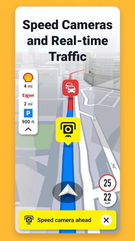
Still Navigating, Now With Traffic Cameras: MapQuest
Access to traffic cameras to see road conditions.
Turn-by-turn directions and alternative routes based on live traffic conditions.
Customization for icons and frequent destinations
Map data is not as robust as Google-based options.
May track your location in the background (check your settings), which is hard on battery life.
You might remember MapQuest as the program from the 1990s where you put in start and end locations and—wait for it—printed out the directions to take in your car. MapQuest has progressed since then, providing a solid app for turn-by-turn navigation with handy features like favorite locations and night mode.
Best Live Traffic Alerts: ETA
Beautiful user interface.
Estimates travel time for driving, walking, and transit.
Includes Apple Watch complication.
Not available for Android.
Runs in the background, which decreases battery life.
With a glance at your iPhone and the ETA app, you can see the travel time to your favorite places—by car, walking, or public transit. The app integrates with Messages, Siri, and Today View to provide a gorgeous way to remain punctual and let your friends or coworkers know precisely when you'll arrive.
Get the Latest Tech News Delivered Every Day
- The 7 Best Google Maps Alternatives of 2024
- The 13 Best Android Auto Apps of 2024
- The 5 Best GPS Apps for iPhone of 2024
- The 20 Best Free iPad Apps of 2024
- The 10 Best Road Trip Planner Apps for 2024
- The 9 Best Tizen-Compatible Apps For Samsung Smartwatches
- Best Free GPS Turn-By-Turn Navigation Apps
- The 9 Best Travel Apps for 2024
- The 17 Best Wear OS Apps of 2024
- The Best 8 Galaxy Watch Apps For 2024
- The 9 Best Summer Apps of 2024
- Android Auto vs. Apple CarPlay: What's the Difference?
- 7 Free Offline GPS Apps for Android
- The 7 Best Shared Calendar Apps of 2024
- The 10 Best Apple Watch Apps of 2024
- The 20 Best Free iPhone Apps of 2024

7 Best Apps to Check Road Status (Android & iOS)
There’s nothing more annoying than getting stuck in traffic while going somewhere important. Luckily, we’re here to help you avoid these kinds of situations.
We’ve picked up the best apps to check road status for Android & iOS you could try. These apps offer traffic warnings and help you pick the optimal route with a few taps. With these apps, you’ll always be there on time, and will easily avoid road accidents as well. Have a look!

It’s a social navigation app that covers all the features you could need while at the wheel. With this one, you’ll get to navigate through town way faster and safer. All the classic tools are included: you get a turn-by-turn GPS assistant, along with instant traffic info.
You’ll also get to see all the accidents on your path and rebuild the path with one tap if needed. The app usually offers several always to reach a destination point, and each one shows the time the road is going to take.
The app also comes with a speedometer and parking assistant to find the best parking spots nearby. As for the social part, the app covers a bunch of lists made y users that include the best restaurants, diners, and must-visit places.
You may also like: 11 Best Offline Navigation Apps
Google Maps
You will get fast updates with this app. It has current information on the status of roads. You can find out about all the traffic jams. The app has a smart route creation technology. It analyzes the status of roads and builds the most convenient and safe route that doesn’t take much time.
If you need to know the schedule of public transport, the app will help you with this. The app will also show you all the places where you can eat, relax or buy something. You can enable the automatic construction of daily routes.
The app will analyze the status of roads in advance and choose the fastest roads. It receives information from satellites. You can find out information about recent traffic incidents. Help other people and also tell them about traffic accidents.
This app lets you avoid unwanted situations, traffic, and all that. You will be aware of the condition of the streets in your city. The app monitors events on your path and updates them instantly. You can find out about weather conditions, as well as traffic jams.
It will help you get a quick route to your home or work. You will see the distance and time that the route spends. The app provides several options for the path and can change it during the trip to avoid new traffic or car crashes.
The app syncs to the music player of your smartphone, so you could play your fave songs while at the wheel. Plus, it shows you the exact time you’ll get to the point. You can also use it to find the cheapest gas stations nearby.
Traffic Spotter
As you may guess by the name, the app is mainly focused on traffic reports and incidents. Its main goal is to provide all the info you may need to alter your current route. The app covers real-time traffic monitoring, so you could get to your destination point faster.
The traffic info is quite detailed though, you’ll get to figure out which are the slowest parts of your path to avoid them. And you know what is just as important as traffic when it comes to driving? Weather! The app will warn you if there’s rain coming along with what kind of rain it is (freezing, moderate, or else).
There are forecasts for the next three hours or smth, and you can set notifications to not miss anything. Beyond that, the app alerts you of all the incidents and car crashes on your way. And if you’ll lever spot anything like that yourself, you’ll get to report it with one tap.
Check also: 6 Best Parking Apps In the USA
That’s another navigational app that gives you live traffic updates. It’s a one-stop GPS app in general, it lets you build routes, share your GPS data, and much more. In fact, the app gives you an overview of all kinds of situations on the entire route.
Plus, the app comes with line guidance, so you’ll never miss a turn ever again. You may also add personal prefs to be considered while building a route (like when you just don’t want to drive through certain streets or areas).
The app also has a floating mode, so you can keep an eye on the map while using other apps (which is obviously not recommended, but everything happens). All the maps work offline as well, so no worries there.
That’s one of the OG navigational apps that originally existed as a desktop version. Herewith, the UI and design of this app are one of the best out of the entire list. The app offers in-depth navigation tools with driving directions, and voice assistance is covered as well.
Plus, it offers traffic info that you can use to change your path and avoid being late to wherever you need to be. There’s even a live traffic cam that lets you see how many vehicles are actually on the lane. It also has a speedometer to compare your speed with the road limit.
And the best thing is, the app lets you find and reserve hotels on the go with no effort. It’s also helpful in finding the cheapest gas costs, stores, and diners nearby.
You may also check: 12 Best Speed Radar Gun Apps
And lastly, there’s an innovative GPS app with maps that get monthly updates to elevate your experience. It gives you precise traffic info, so you could rebuild your paths on the go. It even offers speed cam alerts, so you won’t need an extra app for that.
The incident alerts are included as well, and you’ll get to see where the incident is exactly. And if there’s a car crash, what line is it in. s for the navigation part, the app offers voice-guided assistance and precise directions that are easy to follow. There’s a special mode for walking directions and tourists if needed.
You also get access to offline 3D maps of multiple countries around the globe. There are also a bunch of safety tools that make it way more simple to drive in unfamiliar areas.
Other great apps:

11 Free Virtual Staging Apps for Home Design

11 Free Instagram Analytics Apps for Android & iOS

9 Best Alarm Clock Apps With Math Challenges

5 Best Road Maintenance Simulators for Android & iOS

13 Best Anime Fighting Games for Android & iOS

15 Free Texting Apps for iOS and Android
CDOT launches new, user-friendly road condition and travel planner website and mobile app
News release.
Statewide - The Colorado Department of Transportation launched a new, easy-to-use COtrip.org website on Sept. 29 that features a new 511 map that will allow drivers to safely navigate Colorado roads. While motorists have been using COtrip.org for nearly two decades, this updated website will offer new features that will help travelers plan their route ahead of time, and be prepared for road or lane closures or adverse road conditions.
“This is an exciting time for our agency,” said Bob Fifer, CDOT’s branch manager of the Intelligent Transportation Systems & Network Services. “We are evolving legacy systems to better serve the traveling public. The new website brings more of our transportation technologies into one lens, improving the customer experience. We added several new features, while reducing system maintenance costs. Now, travelers can customize routes from point A to point B to see if their trip may be impacted by any road or lane closures. Motorists will have an easier time identifying road closures, road conditions and construction impacts, all while replacing outdated technologies.”
The new website incorporates the following new features:
Traveler Information & Layers
The COtrip website is powered by a dynamic Google Map™. Motorists can use the map as they would any Google map and click on the icons for more information. Icons are displayed on the map by checking or unchecking the boxes in the layers toolbar. Layers available and what data the layers provide is described here .
Trucker’s Layers
The new Trucker Mode features resources specific to commercial motor vehicle operators, including the following layers defined here .
My COtrip & Travel Alerts
Motorists can log-in in or sign up here for their own COtrip account to subscribe and manage their travel alerts. They can also save their favorite routes and cameras, and customize their travel preferences.
COtrip on Social Media
COtrip traveler information is automatically posted to the @ColoradoDOT Twitter feed. New roadway hashtags and Twitter threads were rolled out in Spring 2021, making it easier for users to track and stay updated on closures and incidents from CDOT. Follow @ColoradoDOT on Twitter for real-time travel information and road conditions.
511 Telephone Service
The 511 telephone service is an interactive, voice-activated traffic information system motorists can access by calling 511 (within Colorado) or 1-800-288-1047 (nationwide). This system has not changed, and will continue to provide a real-time option for travelers to get road conditions and traffic information. Learn more about 511 and how to use this service here .
“The updated website will be a great new tool for the public, however, we also wanted to bring the same information to your mobile device. ” said Fifer. “With that in mind, we are pleased to announce that we are also launching a brand new mobile app on Oct. 1. Now travelers will be conveniently informed no matter where they go. We are committed to continuously improving access to highway information and technologies.”
The new COtrip Planner mobile app was designed to meet the growing trend of information on mobile and tablet devices for the traveling public. The COtrip Planner app provides statewide, real-time traffic information, and works on smartphones and tablets that operate on iOS and Android platforms. Download the app in the Apple Store or Google Play Store starting on Oct. 1.
The app will be fully implemented in three phases
- Traveler app with hands-free, eyes free functionality with customized CDOT layers now available
- Winter-specific layers including weather warnings, weather stations, plow tracker with CDOT snowplow contest names, and Express Lanes
- My COtrip accounts integrated and new map search functionality, including event and camera clustering, predefined routes/areas, and adding an electronic sign layer
- Social sharing of cameras and road conditions will also be available
- Turn-by-turn directions and recommended routes to user mapping app (Google Maps, Apple Maps, Waze)
- Alert banners and push notifications
- Rockfall and wildlife reporting
The COtrip Planner app also includes a feature called TellMe, which enables app users to be hands-free on their route. TellMe detects the user's current location, speed and direction of travel to announce upcoming road conditions and traffic incidents as they travel along their route.
“We want Coloradans and visitors to our great state to have all of the information they need to plan a safe trip, no matter where they go on our state highways and interstates,” said Fifer. “We hope all drivers will take advantage of the website and mobile app before getting into their vehicles for a safe and more convenient trip as both tools will help to eliminate any ‘surprises’ on the roadway.”
You Are Invited
Media partners are invited to join us on Oct. 5 at 1 p.m. for a tutorial of the new website and mobile app as well as a chance to interview Executive Director Lew and CDOT’s Branch Manager of the ITS & Network Services. This is your chance to ask questions related to how the change will help your method of reporting as CDOT knows the COtrip cameras are frequently used by its media partners.
WHEN: Oct. 5 at 1 p.m.
WHERE: Zoom link to come
WHO: Executive Director Shoshana Lew and Bob Fifer, CDOT’s Branch Manager of the Intelligent Transportation Systems & Network Services
Download the COtrip App!
The new COtrip Planner mobile app was designed to meet the growing trend of information on mobile and tablet devices for the traveling public. The COtrip app provides statewide, real-time traffic information, and works on smartphones and tablets that operate on the iOS and Android platforms. Starting on October 1, visit the Google Play Store (Android devices) or the Apple Store (iOS devices) to download!
Say hello to the transformed Idaho 511
Welcome to Idaho 511
Get started to discover new and exciting features!
Signing up with Idaho 511
- Creating an account is NOT mandatory on this website; however if you do, you’ll be able to personalize your experience and receive traffic notifications.
- Select ‘Sign Up’ from the menu options in the top right corner
- Enter your name, email, and create a password. Click ‘Sign Up' when done.
- You will get an email to verify your account, click the link that was sent to your email.
- Including a phone number will allow you to receive text notifications, you will receive an SMS (text) with your confirmation code. Note this is in addition to the email verification.
Creating & Saving a Customized Route
- Enter your start and end locations by typing the addresses into the address fields. Alternatively, you may also right click on the map. Once you have entered the route locations, click ‘Drive’.
- Review the routes generated and select the one that suits you best.
- When done, enter a name for your route and click ‘Save’.
Creating a Notification for your Route
- Once your route is saved, you will be asked if you want to be notified of events on this route. Click ‘Create Route Notification’
- You will be redirected to the notification creation page. Enter the required information for your route, select a delivery option (email or SMS), and click ‘Save’.
- You will now be notified of any future events that affect your route.
Announcements
There are currently no announcements at this time.
Stay Aware in Work Zones
Work Zones are temporary. Actions behind the wheel can last forever. Learn more @ itd.idaho.gov/travel .
Idaho Transportation Department is Hiring!
Learn more @ ITD-Careers
Download Idaho 511 App
- Idaho 511 Android App
- Idaho 511 iOS App
My Cameras Toggle
To add to My Cameras View:
- Map page - Click on a camera icon on the map, then click the "My Cameras" button at the top of the camera popup. Select from the Camera View list to add or de-select to remove.
- Camera page - Click on the three dots icon below the camera image to access the "My Cameras" option. Select from the Camera View list to add or de-select to remove.
- Closed/Stopped
Would you like to be notified of events and road conditions on this route?
Default options for receiving Event and Road Condition Notifications:
- 6 AM - 6 PM
County Road 26 opens to limited travel on Monday due to U.S. Highway 50 bridge closure

GUNNISON — This weekend, the Colorado Department of Transportation (CDOT) and Gunnison County officials have been working together to speed up improvements to County Road 26 so it can open on Monday.
Once open, this county road can be used for limited travel between Montrose and Gunnison.
According to a press release from CDOT, engineers are continuing to perform safety inspections of the U.S. Highway 50 bridge.
This bridge closed on Thursday, April 18, after an inspection revealed a crack in one of the girders.
WATCH: CORRECTION: A crack causes a bridge to close between Gunnison and Montrose
CDOT says that they recognize that the U.S. 50 bridge closure creates a significant detour for those looking to travel between Montrose and Gunnison which is why they have been working to get this shorter access route opened up.
They also say that their partnership with Gunnison County will continue as the county road is fortified with gravel and traffic is mangaed to a level that the road can safely withstand.
Starting Monday, April 22, pilot cars will lead passenger vehicles along the county road two times a day in each direction.
Because CR 26 is an unpaved, high-mountain road that was not built to accomodate the same amounts of traffic as the U.S. 50 bridge, travel times will be limited to
- 6:00 to 6:30 a.m. & 6:00 to 6:30 p.m. for westbound travel
- 7:00 to 7:30 a.m. & 7:00 to 7:30 p.m. for eastbound travel
Those looking to travel westbound can meet the pilot cars near the intersection of CO 149 and CR 26. Those looking to travel eastbound can meet the pilot cars near the intersection of U.S. 50 and CR 26. The travel time using this access route is expected to be 30 minutes or more.
Commercial vehicles over a 16,001 gross vehicle weight are prohibited from using this route.
County Road 26 will only be available for essential travel and only during the timeframes listed above.
During all other times the road will remain closed due to the ongoing restoration work needed to make sure that the road remains safe to travel.
The recommended detour for northbound travel continues to be via Interstate 70. The recommeded detour for southbound travel continues to be via U.S. 160.
These detours add six to eight hours of travel time.
For additional information about this project, you can
- visit the project website
- call the project team at 970-648-4423
- email the project team at [email protected]
____ Watch KOAA News5 on your time, anytime with our free streaming app available for your Roku, FireTV, AppleTV and Android TV. Just search KOAA News5 , download and start watching.
Report a typo
Sign up for the Breaking News Newsletter and receive up to date information.
Now signed up to receive the breaking news newsletter..

News5 Mobile App
Multi-vehicle crash causes traffic delays in downtown Tuscaloosa
by ABC 33/40

TUSCALOOSA, Ala. (WBMA) — A multi-vehicle crash caused traffic delays in downtown Tuscaloosa Wednesday night.
The Tuscaloosa Police Department said three vehicles were involved and there were minor injuries.
- SEE ALSO: Three killed in Gadsden wreck
- SEE ALSO: Tuscaloosa development gets closer to becoming reality
The incident happened near Embassy Suites.
No additional details were immediately provided, but will be added when they become available.
Man faces 3 counts of arson after IndyGo bus catches fire
INDIANAPOLIS (WISH) — A man faces three counts of arson after a Wednesday morning fire engulfed an IndyGo bus on the near-north side, a police report says.
An Indianapolis Metropolitan Police Department report says 45-year-old Demarcus McCloud was arrested. Court records show McCloud has an extensive criminal history, including eight separate sentences in the Indiana Department of Corrections. Most recently, he had a 2023 conviction for criminal trespassing.
In the police report, McCloud’s address is listed as Horizon House, a homeless shelter that helps people secure and maintain housing.
The fire caused $2 million in damages to the bus and the bus stop, the Indianapolis Fire Department says. It turned over the investigation to the federal Bureau of Alcohol, Tobacco, Firearms and Explosives.
A video shared on social media around 7:15 a.m. Wednesday showed the burning, northbound bus parked next to the station on Meridian Street south of 38th Street. The Red Line rapid-transit bus runs through the area that several businesses and apartment buildings, and the North United Methodist Church.
The Indianapolis Fire Department responded within minutes, noting the fire was out by 7:45 a.m.
Carrie Black, director of communications for IndyGo, noted the quick actions of the bus driver in evacuating four passengers. Two passengers were taken to Eskenazi Hospital with slight injuries, Indianapolis Fire Department says.
Witnesses had told police someone on the bus had set the fire.
The fire and police departments confirmed the blaze was not due to any malfunction with the bus or its electrical systems.
The bus stop reopened after cleanup crews spent several hours there.
“IndyGo is pleased to learn a person has been detained in connection with a bus fire that happened this morning along the Red Line at 38th and Meridian streets. A joint investigation including IndyGo, the Indianapolis Fire Department, Indianapolis Metropolitan Police Department and the Bureau of Alcohol, Tobacco, Firearms and Explosives is underway. “‘The safety of our riders and teammates is always our top priority,’ said IndyGo Interim President and CEO Jennifer Pyrz. ‘We’d like to take this opportunity to applaud our coach operator who did everything right and followed ‘See Something, Say Something’ operator training. As a result, he quickly jumped to action, ensuring riders got off the bus quickly and with no major injuries, likely saving lives today.’ “The Red Line station at 38th and Meridian streets suffered minor surface damage. Cleanup is complete, and the station has reopened. The previous detour has been canceled, and the Red Line has returned to its normal route. This incident and the loss of the bus should not directly impact Red Line operations. Regarding the repairs and/or replacement of the bus, it is fully insured, and IndyGo is working with its insurance company on next steps.” IndyGo
Trending stories
- Indy developer faces pushback over ‘Cracker Jack, shotgun houses’
- Tesla earnings plunge even more than forecast
- Sale of Circle Centre Mall completed; $600M investment planned
- Bodies of missing kayakers recovered from White River after weeklong search
- Police officer fired from job after outcry over arrest of teenager
MORE STORIES
Gridlock Alert
Gridlock alert: prepare for traffic this weekend with widespread closures on houston-area freeways.

HOUSTON, Texas (KTRK) -- Drivers should prepare for widespread lane closures across the Houston area this weekend.
The east side of the Houston area will see the majority of the slowdowns, with part of East Sam Houston Tollway expected to remain closed this weekend and through the summer.
Check this list for major closures and don't forget to check your route before you head out this weekend:
East Sam Houston Tollway (Beltway-8)
- Southbound at the Ship Channel Toll Bridge
- Two lanes closed
- 10 p.m., Friday, April 19 to 9 p.m., Sunday, April 21
- The right lane will remain closed until early September. Plan for additional slowdowns on the southbound side of the bridge through the summer.
- Westbound Spur 330/Decker to Monmouth in Baytown
- Two inside lanes
- 9 p.m., Friday, April 19 to 5 a.m., Monday, April 22.
- Drivers will have an open travel lane but expect delays.
I-610 North Loop
- Westbound from Hardy Toll Rd/Spur 548 to Airline
- All mainlanes
- 9 p.m., Friday, April 19 to 5 a.m., Sunday, April 21
- Use the North Loop connector to I-45 North and U-turn at Crosstimbers to access I-610.
METRORail Purple Line
- Closed Saturday and Sunday for rail improvements
- Palm Center to Eado/Stadium station
Free shuttles are available but allow extra time for travel.
ABC13 has real-time traffic data to help you navigate Houston's roads and avoid traffic delays.
Live traffic map
For news updates, follow Elissa Rivas on Facebook , X and Instagram .
Related Topics
- CONSTRUCTION
- GRIDLOCK ALERT
- ROAD CLOSURE
- TRAFFIC DELAY

Ramp at I-69, Loop 610 interchange to shut down for 3 months

Gridlock Alert: Traffic areas to avoid over the weekend in Houston

Plan ahead this weekend! Here's a Gridlock Alert that could clog plans

NOW OPEN: Construction complete on I-610, I-69 interchange, TxDot says
Top stories.

Union says packages at risk as 600 USPS workers robbed last year

Widow says husband would be alive if 'certain things had not happened'

Judge won't dismiss lawsuits against Travis Scott over Astroworld

Houston mother-son accused of stealing more than $1M in scheme
- 3 hours ago

Man accepts plea deal in 2022 killing of worker over just $2
Family wasn't notified when organ transplant program was suspended
- 2 hours ago
Houston Public Works plans to send 'set rate' to reduce high bills
Harris County Judge says she hasn't met with Mayor John Whitmire
IMAGES
COMMENTS
Waze is a community-driven navigation app that helps you find the best route to your destination, avoid traffic jams, and save time and money. Waze also offers carpooling options to share rides with fellow drivers. Download Waze and join millions of drivers who share real-time road information.
Road Trip Weather: Check for snow, rain, storms, tornados, high winds and radar on your route with the Drive Weather App.
A Road Trip Weather App. Weather on the Way is a new travel weather app that provides a detailed weather forecast for your driving route. Thanks to combining forecasting and navigation, you get weather conditions precisely at a time you will be driving through. Perfect for road trips
Highway Weather is the best weather app for traveling. Our interactive features provide ongoing updates for road weather information based on your specified arrival and departure times. You'll know when to stay on the road, when to get off the road, which road to take — and where to steer clear of debilitatingly bad weather.
Waze is a community driven navigation app that helps millions of users get to where they're going through real-time road alerts and an up-to-the-moment map. Thanks to our network of drivers, Waze saves you time by instantly alerting you to traffic, construction, crashes, police and more. From traffic-avoiding reroutes, real-time safety ...
Check the Road Weather Conditions on Drive Weather. Drive Weather takes the guesswork out of figuring out when and where the bad weather is! ... BEST MULTI-STATE TRAVEL APP EVER!!! DriveWeather is a game changer for planning road trips! For 30+ years I spent hours checking multiple sources when planning a interstate trip, and using the ...
Waze is a community driven navigation app that helps millions of users get to where they're going through real-time road alerts and an up-to-the-moment map. Thanks to our network of drivers, Waze saves you time by instantly alerting you to traffic, construction, crashes, police and more. From traffic-avoiding reroutes, real-time safety ...
Waze ( Android, iOS) is a crowd-sourced traffic map and navigation app. Users can check out traffic conditions based on real-time information from other Waze users, complete with reports on road ...
It's the best weather app you can have on the road. Features and benefits: • Weather forecast for points along your route. • Avoid unexpected delays. • Temperature, conditions, chance of precipitation, weather warnings. • Live Snow & Rain Doppler Radar. • Pick the route with the best weather. • Choose the time of departure up to 7 ...
All planning features are provided free of charge! For the hands-free active driving mode, a subscription is required. • Receive automatic updates while on the road. • See updates instantly in the app. • Get notifications when the app is running in the background. • More features currently in development! Subscription Details:
Travel weather forecasts for your entire road trip at the time you will arrive. Weather alerts, radar, traffic cameras, and plan for rests. ... • Receive automatic updates while on the road. • See updates instantly in the app. • Get notifications when the app is running in the background. • More features currently in development! ...
GasBuddy. Paying for fuel can eat up a good chunk of your road trip budget, but GasBuddy can save you a few bucks. The app crowdsources up-to-date fuel prices for more than 150,000 gas stations ...
The Apple Maps app was late to the traffic-app party and had to deal with some bumps in the road before it became a worthy rival to Google Maps. Apple now offers improved maps, satellite imagery, city guides, and cycling navigation. The Apple Maps app recommends travel times and routes based on your frequent locations and calendar.
These apps offer traffic warnings and help you pick the optimal route with a few taps. With these apps, you'll always be there on time, and will easily avoid road accidents as well. Have a look! List of reviewed apps: 1. Scout Maps. 2. Google Maps. 3.
You need to enable JavaScript to run this app. DriveTexas. You need to enable JavaScript to run this app.
Whether you need to plan a road trip, a commute, or a walk, MapQuest Directions can help you find the best route. You can customize your journey with multiple stops, avoid tolls and highways, and get live traffic and road conditions. You can also discover nearby attractions, restaurants and hotels with MapQuest Directions.
The TripCheck website provides roadside camera images and detailed information about Oregon road traffic congestion, incidents, weather conditions, services and commercial vehicle restrictions and registration.
The COtrip Planner app also includes a feature called TellMe, which enables app users to be hands-free on their route. TellMe detects the user's current location, speed and direction of travel to announce upcoming road conditions and traffic incidents as they travel along their route.
With the OHGO app, drivers get real-time traffic updates, personalized route notifications, can view live traffic cameras and get accurate delay times. #knowbeforeyougo. ALERT ... View current road conditions, like icy, wet or snow-covered roads, and get to your destination safely. Website ...
Provides up to the minute traffic and transit information for State View region in Idaho. View real time Road Conditions details on a list page. ×. Skip to main content. Idaho 511. Trucker Mode User. Sign ... Free Apps Link to Flickr in new window. New
Real-time traffic in Moscow on Yandex Maps. Driving and public transport directions that account for traffic, on the web and in the mobile app. Find the right street, building, or organization, view satellite maps and street panoramas with Yandex Maps.
ALGO Traffic provides live traffic camera feeds, updates on Alabama roads, and access to exclusive ALDOT information.
Download Idaho 511 App. Provides up to the minute traffic and transit information for Idaho. View the real time traffic map with travel times, traffic accident details, traffic cameras and other road conditions. Plan your trip and get the fastest route taking into account current traffic conditions.
JACKSON, Tenn. — A collision took place earlier this afternoon, April 24, on North Parkway in front of Jackson State Community College. Our WBBJ 7 Eyewitness News crew got to the scene around 4: ...
Starting Monday, April 22, pilot cars will lead passenger vehicles along the county road two times a day in each direction. Because CR 26 is an unpaved, high-mountain road that was not built to ...
FRESNO, Calif. (KSEE/KGPE) - A new jurisdictional arrangement is coming to the City of Fresno to enhance traffic flow and safety, being what city officials describe as a significant step towards ...
ABC 33/40 Weather App. Weather Maps. Fish and Game Forecast. Sports. ... Game Center. Watch. Now. 64. Thu. 81. Fri. 81. Multi-vehicle crash causes traffic delays in downtown Tuscaloosa. by ABC 33/ ...
FISHERS, Ind. (WISH) — Fishers city government first restricted the intersection of 141st Street and State Road 37 in 2022. The city had planned to build an elevated roundabout, but budgetary ...
️Bus Fire ️ Please avoid the area around Meridian St. and 38th St. An IndyGo bus is fully engulfed, snarling traffic in all directions.
ABC13 has real-time traffic data to help you navigate Houston's roads and avoid traffic delays. Live traffic map For news updates, follow Elissa Rivas on Facebook , X and Instagram .