If you Rev it, REVER it.

Your search for the best roads, race tracks and off-road trails ends here with a motorcycle trip planner built for adventure. Uncover more than 3,000 motorcycle road trip maps around the world with the REVER motorcycle route app.
Record your activities anywhere in the world with an accurate motorcycle ride tracker. Map my motorcycle ride features require no cell service.


Route Planning Made Easy
The REVER motorcycle route app highlights every epic road for easy reference. Create the perfect ride with a motorcycle route planner and automatically sync it to the REVER App for easy navigation and sharing.
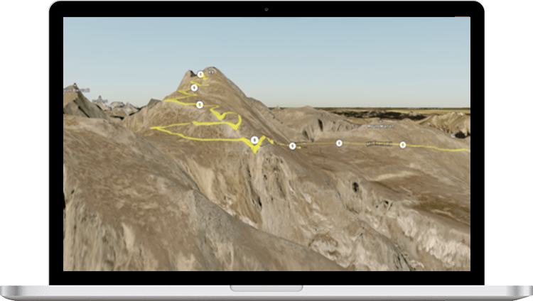
Your expensive GPS has met its match. Get everything you need in a motorcycle GPS app and more like offline maps, turn-by-turn directions, and voice guidance to get you where you're going.
Live Friend Tracking, Challenges, and much more to keep you motivated, safe and connected while exploring motorcycle riding routes near you.

The Word Is Out
Never ride alone again with live friend tracking, challenges and more. Stay motivated, safe and connected with the REVER moto trip planner .

love tracking my rides with Rever . This app does this and a heck of lot more. There is a ton of single track moto rides where I live and the tracking system/gps is very accurate. I like the new feature of auto pause and of course I like to see how fast I ride as this app gives me my highest mph which I can compare with my friends. Before Rever came along I would use Map my ride but this was not a motorcycle specific app. Now I track all of my rides and can share them with my friends. Great app!
KTMColorado
I had planned over 20,000 kms of rides after I had discovered this app. The wife and I are riding 29 states and 3 provinces after I complete a 24 border to border run to Mexico. Planning the trip was easy and with the Butler map overlay completely changed the route we are taking. I was having no luck with the mobile app however... Turns out the email address I used to sign up for facebook was used to log in. Hadn't used that one in years. The found it and it works awesome now! Wicked customer service!
Charles Lott
I love this app , there response to questions and issues are excellent, very prompt and courteous.
Shawn Peters
I ride everyday and this App helps me track my milage , great app...
Steven Pena
I like the record ride feature & I can easily create rides on website , and then use the app on my phone to ride the route.
Dave Dyczewski
The answer then, to my initial question of "Have they really made it better?" would be yes. And as an alternative to other, motorcycle-specific maps, my wife Judy, who is our chief navigator, spent a lot of time comparing several and concluded that the Butler maps are the best.
Ken Bingenheimer
If there is a road not on the map it's probably not worth riding.
Motorcyclist Magazine
The word from the navigator is very clear: The Butler Maps Colorado map is the best .
Best Offroad Trails
Mid-Atlantic BDR
S. California BDR
New Mexico BDR
Washington BDR
Arizona BDR
Colorado BDR
Hollister Hills
Popular Roads by City
Christ Church
Buenos Aires
Mexico City
Popular Roads by Country
South Africa
New Zealand
Czech Republic
Switzerland
United States
Best Roads in the World
Transfăgărășan, Romania
Death Road - Bolivia
Road of Bones
Atlantic Road - Norway
A82 Road, Scotland
Hana Highway
Ruta- Argentina
Chapman’s Peak Drive, South Africa
Rohtang Pass, India
US 550 Million Dollar Hwy
Trollstigen, Norway
Kata Tjuta National Park
Cabot Trail
Trail Ridge Road - Colorado
Susten Pass
Grimsal Pass
Panorama Route - South Africa
Ornevegen (Eagle’s Road)
Ring Road Iceland
The Garden Route
Hidden Highway
Icefields Parkway
Sunshine Coast
Amalfi Coast
Beartooth Pass
Top Rides by US Cities
San Francisco
San Antonio
Philadelphia
New York City
Los Angeles
Jacksonville
Indianapolis
Forth Worth
"You don't stop riding when you get old, you get old when you stop riding." ― Anonymous
- REVER Brigade
Labs & Partners
- Partner With Us
- Press Releases
- Privacy Policy / Terms & Conditions
- Work With Us
- [email protected]
Sign up to our newsletter
© REVER 2024 All rights reserved.
We use cookies to help make Rever better. By visiting this site, you agree to our cookie policy .
50% Labor Day "Flash Sale"
COVID-19 Updates
Vaccine and Booster Information
Reopening Guidelines
Ride On Trip Planner App
Download and Use the App NOW!
Download the free, easy-to-use Ride On Trip Planner from the Apple App store or the Google Play store. It's fully functional.
In the app:
- Choose your current location and destination.
- Pick the route that best fits your travel plans.
- Know the exact time the next bus will arrive.
- Get step-by-step directions on how to get to the bus stop and your destination after getting off the bus.
- Be notified when it's time to get off the bus, so you can browse other apps and surf the web without worrying about missing your stop.
The app helps keep you healthy, too! Use its crowdedness indicator to avoid full buses, reducing the spread of infectious diseases.
Or Use the Planner on your desktop or laptop
You can also use the Trip Planner in your browser - no download needed!

Lose an item on a Ride On bus? Contact our Lost & Found .
Route Planner
- Plan a Road Trip
- Plan a Flight
- Find an Airport
- Where to Stay
- All Questions
Road trip planner
Starting City
Destination City
Or switch to flying
Planning a road trip?
Get advice from people who have done the same trip.
The Trippy road trip planner automatically calculates the optimal itinerary including stops recommended by Trippy members, favorite restaurants and hotels, local attractions and things to do based on what people who live in the area have suggested, and more.
Once you have a quick trip planned, you can customize every detail, adding or removing stops, or changing what time you leave in the morning or how long you stay at each stop. Then you can save your custom trip and share it with friends and family.
Let us know if you have requests for more features you'd like to see in the trip planner!
Browser not supported
This probably isn't the experience you were expecting. Internet Explorer isn't supported on Uber.com. Try switching to a different browser to view our site.
How much does a ride with Uber cost?
Plan your next trip with the price estimator.
How prices are estimated
In most cities, your cost is calculated up front, before you confirm your ride. In others, you will see an estimated price range (see applicable price terms in your city). Here are some fees and factors that can affect your price:
The base rate is determined by the time and distance of a trip.
Operating fee
In your city, a flat fee might be added to each trip. It helps support operational, regulatory, and safety costs.
Busy times and areas
When there are more riders than available drivers, prices may temporarily increase until the marketplace is rebalanced.
Ways to ride in the area
Making money by driving with the uber app, behind the wheel.
Drive using Uber when you want and make money on your schedule.
Find out what resources and promotions are in the app that can help you maximize your earnings.
Frequently asked questions
After you arrive at your destination and exit the vehicle, your final cost will be automatically calculated and charged to the payment method you’ve set.
Yes, you can request a ride to and from most major airports around the world. Go to our airports page to see the locations where Uber is available.
In most cities, Uber is designed to be a cashless experience. In cities where cash payments are available, this option must be selected before you request your ride.
Open the app and input your destination in the “Where to?” box. The price estimate for each ride option will appear; scroll to see what’s available in your area.
Do more in the app
Download the uber app.
Scan to download
Sign up to ride
- Our offerings
- How Uber works
- Diversity, equity, and inclusion
- Sustainability
- Investor relations
Sign up to drive & deliver
Create a rider account, order delivery with uber eats, sign up for uber for business, sign in to drive & deliver, sign in to ride, sign in to order delivery with uber eats, sign in to your uber for business account, drive & deliver, ride with uber, uber for business, manage account.
- Rider Tools
- Fares & Passes
- Board of Trustees
- Current Projects
- Doing Business
- Schedules & Maps
- Transit Royale
- Receive Service Alerts
- Vehicle Locator
- Plan Your Trip
Use Transit for the best mobile trip planning and fare payment experience. Click here to download UTA’s preferred app for trip planning, real-time tracking, multimodal connections and fare payment. You can also use the app to subscribe to service alerts and get notified about detours and service disruptions.
Google Maps
When using a computer, click here to plan your trip with Google Maps. (Detour and service disruption alerts are not available on Google Maps.)
Select Language:
We are Ride with GPS
We make it easy to map, analyze, record, and share your bike rides.

Discover routes
Find a great route, and customize it with our route planner.
Enjoy your ride
Stay on course, record your journey, and organize your photos with our mobile app.
Inspire others
Create a Ride Report to share your journey with friends and family.

We want you to have more fun on your bike. Ride in new places, and let us take care of the details.
Build the perfect route.
Find a great route, and tweak it with our planner. It's easy to find the best routes wherever you are, and our tools let you adjust difficulty and start location.
Sync your devices
Our mobile app would look great on your handlebars, but we fully support and are integrated with all popular devices from Garmin and Wahoo.
Track your stats and goals
Set a custom goal for the dates that matter to you. Keep it simple, and track your yearly stats, or use our analysis tools to dive deeper into your ride data.
Made by riders, for riders
Our users go on better rides, more often. Bring us along for your next great ride; we'll do our part.
- Mobile Route Planner
- Web Route Planner
- Integrations
- Organizations
- Experiences
- Cycling Clubs
- Cycling Events
- Global Ambassadors
- Help Center
Tell us a little about yourself
Sign up By signing up, you are agreeing to our Terms of Service .
Share via email
Embedded widget, get the ride with gps mobile app.
Rock solid GPS logging, helpful navigation, live logging and more are all available when you install our app.
Questions or Comments?
Customer service:, connect with us.
- Facebook (Open external link)
- Twitter (Open external link)
- YouTube (Open external link)
- Instagram (Open external link)
- LinkedIn (Open external link)
Drive Less. Do More.

- Routes & Schedules
- Plan Your Trip
- Track Bus or Train
- Service Alerts
WATCH NOW: Your Safety Is Our No. 1 Priority
METRO invests in people, equipment and technology to help protect your safety. Learn how the METRO Police Department serves our community.
Watch Videos

Exciting Career Opportunities
METRO is an organization of exceptional people with extraordinary values. We have a positive, supportive work culture with friendly employees and the opportunity to advance from within.
We have a variety of career opportunities available and have retained the services of executive search firm K&A Partners to assist us in identifying our next president and CEO. METRO offers outstanding benefits for full-time employees including coverage for medical, prescription drugs, dental, vision, retirement and more. We also offer a $200 monthly benefit for child care assistance, up to $5,000 a year in tuition reimbursement and financial incentives for newly hired bus operators, bus mechanics and facilities maintenance personnel.
Recent News & Activities

See What METRO is Doing to Build a More Sustainable Transit System >
METRO TRIP App Has Been Renamed ONE to Ride >
Ride METRO to Cheer on the Astros at Minute Maid Park >
METRO Podcast: Houston Drivers are Wasting Time and Money in Traffic >
Learn More About the METRO Police Department >
METRO Funds Over $4 Billion in Road Maintenance and More >

The voter-approved Moving Forward Plan is giving you more ways to move around our region.

Rider Rewards
Score food and entertainment discounts around the region just for riding METRO.
ONE to Ride App
Plan and manage your trip on METRO Local bus, Park & Ride bus, METRORail or METRORapid using an interactive map.

Need Answers? We’re Here to Help
Select a topic you have a question about
Your Safety Is Our No. 1 Priority
Learn the ways METRO is keeping eyes on the community as we reinforce patrols throughout the system.
Hear how dedicated METRO Police and Bus Operators were able to safely reunite a lost child with her family.
From police patrolling to live security monitors, METRO is building a safer transit system.
The MPD Connect app provides multiple ways to communicate with the METRO Police Department.
METRO Police Department's K-9 Unit works alongside other specialty units to keep the system safe.
At METRO, safety is part of everything we do.
Preview METRO's New Mobile Website
Website Preview (mobile)
Every bus route now has its own page. Each METRORail line has a linear map showing nearby connections and services. You can even track the arrival of your bus or train directly from the home page. Watch the video to see how it all looks and works on a smartphone.
Let us know your location and the new METRO website will provide custom results about nearby transfer facilities, nearby METRO public parking, nearby retailers that carry METRO fare cards - and more. Watch the video to see how it all looks and works on a smartphone.
Preview METRO's New Desktop Website
Website Preview (desktop)
Every bus route now has its own page. Each METRORail line has a linear map showing nearby connections and services. You can even track the arrival of your bus or train directly from the home page. Watch the video to see how it all looks and works on a desktop device.
Let us know your location and the new METRO website will provide custom results about nearby transfer facilities, nearby METRO public parking, nearby retailers that carry METRO fare cards - and more. Watch the video to see how it all looks and works on a desktop device.
Browser not supported
It appears you’re on an older web browser we don’t support. Please try one of the options below so you can view the METRO website.
TARC On-Demand 4+
Rideco inc., designed for ipad, screenshots, description.
Ride TARC on your schedule! TARC On-Demand is a 6-month on-demand pilot ride-share service for New Albany and Jeffersontown brought to you by TARC. Use this app to plan your trip, select your choice of travel, and pay all from your mobile device. Connect with TARC’s fixed route bus service, or travel to and from anywhere within the designated zone. Once you book a ride, you’ll receive a time of arrival and your pickup location. Your ride-share vehicle will be marked with TARC On-Demand branding to guarantee a safe, convenient, and affordable ride to your destination. Get moving with a new ride-share service from the Transit Authority of River City.
Version 3.17.4
We’ve made improvements and squashed some bugs.
App Privacy
The developer, RideCo Inc. , indicated that the app’s privacy practices may include handling of data as described below. For more information, see the developer’s privacy policy .
Data Used to Track You
The following data may be used to track you across apps and websites owned by other companies:
- Identifiers
Data Linked to You
The following data may be collected and linked to your identity:
- Financial Info
- Contact Info
- Diagnostics
Privacy practices may vary, for example, based on the features you use or your age. Learn More
Information
- App Support
- Privacy Policy
More By This Developer
Metro Micro
Iris - A Ride KC Partner
OmniRide On-Demand
WeRIDE Micro
RTC-OnDemand
You Might Also Like
Nomadic Tribe
French-English Learning App
Learn Scottish For Beginners
Moon Scooters
- Schedules/Map
- Tickets/Fares
- Where's My Bus?
Route Changes & Adjustments Effective February 25, 2024
Ride the SunRunner! With service every 15 minutes from 6 a.m. - 8 p.m. and 30 minutes from 8 p.m. - midnight.
Standard Routes
- Route 18 (PCPT)
- Route 19 (PCPT)
- Route 52/52LX
- Route 203 Skyway Connexion (MCAT)
- Central Avenue Trolley
- Downtown Looper
- East Lake Shuttle
- Jolley Trolley Beach Route (PSTA passes accepted)
- Jolley Trolley Coastal Route (PSTA passes accepted)
- Suncoast Beach Trolley℠
Regional Express Routes
Trolley Services
View All Schedules »
Additional Links
- Route Changes & Adjustments
- Rider Alert
- Bus Boarding Charts
- System Map
Links to Other Systems in the Region
- Hillsborough Area Regional Transit Authority (HART)
- Pasco County Public Transportation (PCPT)
- Manatee County Area Transit (MCAT)
Download the Flamingo Fares App
Available on: Google Play | App Store
Visit FlamingoFares.com for more information.
Below is a list of our most popular fares.
View All Ticket Options »
Regular Fare
Reduced fare.
- Flamingo Fares
- PSTA Access Online Ticket Sales
- Universal Photo ID
- TD (Transportation Disadvantaged)
- U-PASS
- Veterans Pass
Other Links
- Trolley Services
- East Lake Shuttle
- Pasco County Transit
WHERE'S MY BUS?
Introducing the Real Time Bus Information. PSTA invites you to experience Real Time Bus Information. The system works with GPS technology and allows PSTA to pinpoint each vehicles exact location at all times. This means we can provide reliable, real-time departure information to passengers .
DOWNLOAD TRANSIT APP »
FIND IT ON RIDEPSTA.NET »
Route Changes
Effective 2-25-24.
Schedule changes go into effect on February 25, 2024
We're the Best of the Best!
PSTA Named Most Outstanding Public Transportation System in the Nation.
Ride PSTA for Only $5 a Day!
Any time. anywhere., st. petersburg td program, effective november 1st, 2023.
Residents who qualify for $0 monthly fare and live within city limits can ride all PSTA routes fare free.
Download Transit,
Psta's endorsed app.
PSTA’s Universal Pass Program, also called UPASS, allows agencies, government employers, schools, and universities to pay PSTA an annual rate in exchange for unlimited public transit access for their employees or students.
PSTA Community Bus Plan
Let your voice be heard.
The Community Bus Plan project is a system-wide planning effort to find ways to enhance the PSTA bus network, focusing on providing increased opportunity to residents through changes to bus routes and schedules.
READ OUR LATEST BLOGS
Deep drive: women in transit at psta, behind the wheel: sunrunner rider julia marchant, deep drive: who rides psta and community sentiment survey results, connect with psta.
Nomadic Matt's Travel Site
Travel Better, Cheaper, Longer
How to Plan a Trip: A Month-by-Month Guide

Trip planning can be a daunting task. Flights, insurance, gear, itineraries, accommodation, and so much more all need to be considered and sorted out before you go.
It’s easy to get overwhelmed , especially when you haven’t done something like this before.
After over close to twenty years of traveling the world, I’ve planned countless trips and vacations for myself, friends, and family, even group tours. In the beginning, it was trial by fire. I learned a lot of lessons the hard way . However, that helped me develop an efficient checklist that ensures I don’t miss anything important during the trip-planning process.
One big question I get asked a lot is when to start planning. To answer that question, this post breaks the planning process down into month-by-month steps so you can plan your next trip with ease.
Here’s how to plan a trip:
Table of Contents
12 Months Out: Decide on Your Destination(s)
12 months out: start collecting points & miles, 8 months out: visa requirements, passports, and vaccines, 4-6 months out: book your flight, 3-4 months out: book your accommodation, 2 months out: plan your activities, 1 month out: get travel insurance, 7 days out: pack.

If you already have a dream destination in mind, great! If not, here are some posts to help you get started:
- 11 Cheap Places to Visit on the US Dollar
- 10 Places to Travel on a Budget
- The Best Tropical Islands in the World
- My Favorite Cities in the World
- My 31 Favorite Places to Visit in the USA
But, this far out, the real thing you want to do is start saving money and figuring out your costs. Accommodation and flights are the obvious ones, but how much do restaurants, attractions, and other activities cost? Knowing these costs will allow you accurately estimate how much money you’ll need. Here is how to research costs:
- Buy a guidebook
- Check out my free travel guides (we break down all costs for each destination)
- Skim the cost of living on Numbeo.com
- Google prices for major activities you want to do, such as scuba diving, winery tours, etc. ( Get Your Guide is a good place to start)
- Use Skyscanner or Google Flights for flight prices and sign up for alerts to get emails if the price changes
- Use Discover Cars to price out (and book) a rental car if you need one
- Use Booking.com and Hostelworld to research accommodation costs
That may seem like a lot but you just want to get a general idea of how much you need to save. You can head to this page to see all my articles on how to save money for your trip .

These days, most cards have welcome offers of 60,000-80,000 points (some can be as high as 100,000) when you meet their minimum spending requirement (generally $2,000-5,000 USD within a 3–6-month time frame). That’s enough miles for a free round-trip economy flight to Europe from the East Coast of North America.
For more information on this subject, check out these posts:
- Points & Miles 101: A Beginner’s Guide
- How to Pick the Best Travel Credit Card
- My Favorite Travel Credit Cards
- How to Earn Points by Paying Your Rent
- The Ultimate Guide to Points & Miles
- How to Collect Points & Miles in Canada
In addition, get a fee-free ATM card. I use Charles Schwab, but there are lots of other banks that don’t charge ATM fees (don’t forget to check your local banks and credit unions too). Here’s how you can avoid bank fees while traveling .
While you likely won’t need a visa to your desired destination, you should still check to make sure. If you’re a US citizen, use the State Department’s search tool to learn about your destination’s entry requirements. (Canadians can use this search tool .)
Additionally, make sure that your passport is valid for at least six months after your trip ends. Many countries require this for entry. Passport application and renewal wait times can be long (the standard is 6-8 weeks in the US), so do this as soon as possible.
Also, research if you need any vaccines for your trip as many countries require vaccines to enter (and I don’t mean COVID). You can learn more about country requirements and recommendations at the CDC’s website . They can help you find a clinic near you as well (if you’re in the US).

Here are two articles on how to score a cheap flight:
- How to Always Find Cheap Flights
- 5 Steps to Booking a Cheap Flight
If you’ve signed up for a travel credit card and received your sign-up bonus, use your miles to book your flight and/or hotel. The further out you book, the more availability there will be. Use tools like Point.me and Awayz to help you find the best redemptions on your points (for flights and hotels, respectively).
But even if you aren’t using miles or didn’t find a cheap flight deal, there are still many ways to avoid being the person on the flight who paid the most for their ticket. My two favorite sites for finding cheap airfare are Skyscanner and Google Flights .

Here are my go-to sites when it comes to finding the best deals on accommodation:
- Hostelworld – Hostelworld has the largest selection of hostels and is my go-to site for finding affordable hostels.
- Booking.com – Booking.com is the best overall platform for finding budget hotels and guesthouses.
- Agoda – Agoda has the best results if you’re heading to Asia (though it sometimes has good US deals too).
I recommend checking the cancelation policy of wherever you book. I like having the flexibility to cancel if something comes up.
If you’re on a tight budget or you want to connect with more locals during your travels, consider joining platforms like Couchsurfing or BeWelcome . These communities allow travelers to stay with residents for free as a sort of cultural exchange.
Long-term travelers can also try housesitting or WWOOFing as well, as they both offer free accommodation (in exchange for pet sitting or farm work, respectively).
Now it’s time for the fun part of travel planning! That means reading books about your destination, learning general travel tips, connecting with online communities, and pre-booking any necessary activities.
Pre-booking ensures you don’t miss out on things that you really want to do on your trip. If you’re going to a popular destination, tours and activities fill up quickly, and if you’re going to a smaller place, activities or tours might only run on certain days and have limited availability.
Either way, Get Your Guide the best place to search for and pre-book activities, tours, and tickets. Local tour operators and attractions can list their offerings on this online marketplace, so you can find tons of stuff here, from food tours to museum tickets with skip-the-line entry.
Get travel insurance . That way, these purchases are protected should something happen that makes you cancel your trip.
A lot of people think, “I’m healthy. I don’t need travel insurance.” But travel insurance is much more than just medical protection. It covers you when your camera breaks, your flight is canceled, a family member dies and you have to come home, or something gets stolen. (That’s why you’ll also want to familiarize yourself with any common travel scams to look out for, as well as how to conduct yourself in order to blend in to avoid looking like a target for petty theft.)
Yes, it’s an added expense. But it’s always better to be safe than sorry. I never leave home without it, because I’ve seen firsthand just what can happen on the road.
I never thought I would pop my eardrum while I was scuba diving in Thailand, break my camera in Italy, or get knifed in Colombia.
Unfortunately, bad things can happen when you’re traveling. True, these events are few and far between. But they can cost tens of thousands of dollars. If you’re not prepared to pay out of pocket, buy travel insurance.
Here are some posts on travel insurance to get you started:
- How to Buy Travel Insurance
- The 5 Best Travel Insurance Companies
- The Best Travel Insurance for Seniors
I never leave home without travel insurance. You shouldn’t either.

I travel with a 45L REI bag and then a smaller day bag. Here’s my suggested packing list to help you take just the right amount of stuff and avoid overpacking ( here’s a list for female travelers ).
Additionally, bring any prescriptions you need for the duration of your trip. Try not to rely on filling those abroad (though bring a prescription and doctor’s note just in case).
With everything taken care of, it’s time to go on your trip and have fun! Make a list of last-minute items you need to pack the day of (your toothbrush, glasses, phone charger, etc.) and check in online beforehand (you can do so 24 hours in advance). (If you’ve got lounge access through a premium travel rewards card , you might find yourself looking forward to getting to the airport early.)
If you’re feeling nervous, don’t worry. That’s perfectly normal. Feeling anxious or unsure is something every traveler experiences. But you’ve made it this far. Trust your planning and follow your instincts. You’re about to have the trip of a lifetime.
Book Your Trip: Logistical Tips and Tricks
Book Your Flight Find a cheap flight by using Skyscanner . It’s my favorite search engine because it searches websites and airlines around the globe so you always know no stone is being left unturned.
Book Your Accommodation You can book your hostel with Hostelworld . If you want to stay somewhere other than a hostel, use Booking.com as it consistently returns the cheapest rates for guesthouses and hotels.
Don’t Forget Travel Insurance Travel insurance will protect you against illness, injury, theft, and cancellations. It’s comprehensive protection in case anything goes wrong. I never go on a trip without it as I’ve had to use it many times in the past. My favorite companies that offer the best service and value are:
- SafetyWing (best for everyone)
- Insure My Trip (for those 70 and over)
- Medjet (for additional evacuation coverage)
Want to Travel for Free? Travel credit cards allow you to earn points that can be redeemed for free flights and accommodation — all without any extra spending. Check out my guide to picking the right card and my current favorites to get started and see the latest best deals.
Need Help Finding Activities for Your Trip? Get Your Guide is a huge online marketplace where you can find cool walking tours, fun excursions, skip-the-line tickets, private guides, and more.
Ready to Book Your Trip? Check out my resource page for the best companies to use when you travel. I list all the ones I use when I travel. They are the best in class and you can’t go wrong using them on your trip.
Got a comment on this article? Join the conversation on Facebook , Instagram , or Twitter and share your thoughts!
Disclosure: Please note that some of the links above may be affiliate links, and at no additional cost to you, I earn a commission if you make a purchase. I recommend only products and companies I use and the income goes to keeping the site community supported and ad free.
Related Posts

Get my best stuff sent straight to you!
Pin it on pinterest.
Pinellas Trail: Treasured bike trail from St. Pete north
By: Author Bonnie Gross
Posted on Last updated: August 1, 2023
The Pinellas Trail is a treasure, and anyone lucky enough to live near it has access to what is probably the best urban bike trail in Florida.
It’s not perfect – it’s not always scenic and riders will experience lots of stops at intersections as the trail crosses road after road.
But how can you complain when you find a wide, paved, well-marked trail that extends for 54 miles through one of the most densely populated areas in the state? I wish it were in my county!

My husband and I bicycled a section of the Pinellas Trail while exploring the spectacular beaches on barrier islands north of St. Petersburg. We took the universal advice you find online: That the most scenic part of the trail is its northern portion, between Dunedin and Tarpon Springs.
We found pretty views, parks to discover, historic buildings and cute downtowns. We also found plenty of suburban backyards, the back-sides of businesses, boring views of commercial roadways and shadelessness.
The Pinellas Trail is a mixed bag, so set your expectations accordingly.

Pinellas Trail was built first to make bicycling safer
The Fred Marquis Pinellas Trail starts in downtown St. Petersburg and follows the old CSX railway right of way for 50 miles to Tarpon Springs and on to the Pasco County line. Its story began in 1983, inspired by the vision of a man whose son was killed riding his bike. The first six-mile section opened in 1990, and it’s been expanding ever since.
It is heartening to see how much it is used, and by all sorts of people. With a separate, well-marked pedestrian lane, it attracts and comfortably accommodates dog-walkers, joggers, wheelchairs and strollers.
You’ll see every type of bicyclist – some poking along on training wheels; others whizzing by on recumbent bikes. With more than 1.5 million users a year, the Pinellas Trail ranks as one of the most heavily used rail-trails in America, according to the Rails to Trails Conservancy.
We enjoyed exploring the Pinellas Trail, particularly the opportunity to stop at interesting spots along the way.

Highlights on the northern section of the Pinellas Trail:
- Dunedin’s downtown , where the Pinellas Trail serves as a “main thoroughfare” because the downtown grew up around the old railroad tracks. Local merchants have embraced the trail, catering to the steady stream of visitors it brings. In cute and historic Dunedin, you’ll find a great variety of ice cream shops, coffee shops, restaurants and breweries, some facing directing on “the Trail,” as residents call it. Here’s our guide to visiting Dunedin , a great base for biking the trail. (Dunedin is 25.7 miles from the start of the trail in St. Petersburg.)

- Weaver Park , just north of Dunedin, where you look through a shaded picnic grove to a view of the Gulf. If you take a short detour off the Pinellas Trail and cross the park and Bayshore Drive, you can head out to the free 725-foot fishing pier with expansive views .
- The Pinellas Trail spur to Honeymoon Island State Park , which runs along the Dunedin Causeway. The trail offers a safe way for bicyclists to pedal to the beach and enjoy scenic views of St. Joseph Sound.

- Wall Springs County Park , a shady spot for a picnic right off the Pinellas Trail a few miles north of Dunedin. Wall Springs was a historical, natural spring, once used as a spa and swimming area. Today, there’s a boardwalk around the old spring with interesting displays explaining the history. (Sorry, no swimming though.) This park is a trailhead on the Pinellas Trail.
- The sponge docks in Tarpon Springs . This touristy few blocks along the Anclote River is full of Greek restaurants. It’s just a few moments detour from the Pinellas Trail.
- North Anclote River Nature Park , near the northern end of the trail in Tarpon Springs. Another spur off the Pinellas Trail heads into a wooded park with shell-rock trails winding around waterways.
Planning your ride on the Pinellas Trail
Pinellas County has done a lot of things right with this trail, and one of them is the extensive, helpful information available. Each section of the trail has a detailed guide, with a map and information about parking, water fountains, restrooms, bike rental and repair shops, restaurants, lodging and more. I printed out this information to plan our trip and used it the whole way. If you’re planning a trip on the Pinellas Trail, I recommend you spend time with this material to plan your route.
As I researched which section of the Pinellas Trail to ride, I found residents expressed concerns about the safety and attractiveness of southern sections of the trail once you leave downtown St. Pete.
One of the most popular sections is the quarter-mile-long Cross Bayou Bridge which spans Boca Ciega Bay. The $4 million bridge was built specifically for the Pinellas Trail — that’s right, no vehicles at all — and the views are terrific.
The Pinellas Trail is generally 15-feet wide and paved with asphalt or concrete. It is flat, except for 10 overpasses and a few hills in Miles 37 and 40 in Tarpon Springs.
More tips on Pinellas Trail
- The Pinellas Trail is rolling out a change in its traffic flow. For the past 30 years, cyclists rode on one side of the trail and pedestrians used the other side. Now, everyone will use the trail on their right-hand side and pass on the left, as drivers do on the roadways. Some users of the trail have objected, but trail managers say this approach is what is used on most paved trails and it works well.
- Cylists looking to cover a distance sometimes bike the whole trail in one direction, stay overnight in Tarpon Springs, and pedal back the next day.
- In our experience, drivers were very courteous to bikers at intersections. Still, you have to slow down and/or stop frequently as you cross streets, which may be a frustration for those who work up some speed.
- Despite its amenities, come prepared with cell phone, extra water and sun screen.
- Does the Pinellas Trail allow electric bikes? The Pinellas Trail permits e-bikes that require a combination of human power and electric motor power. There is a 20-mile-per-hour speed limit.
- Want a trail that is less urban? The Pinellas Trail isn’t the only long, paved bike trail in the region. We love the Withlachoochee Trail , which starts six miles north of Dade City and runs through forests and rural hamlets.
- The Pinellas Trail connects in downtown St. Petersburg with the beautiful North Bay Trail. This multiuse trail extends six miles north from where it meets the Pinellas Trail at First Avenue Southeast at Bayshore Drive, where the Pinellas Trail originates. The first three miles of the North Bay Trail are along a scenic path that hugs the bay with views of parks and historic homes. Read more about this trail in this Florida Rambler story: Seven things to do in St. Petersburg for Old Florida flavor.
- The Pinellas Trail is part of a growing network of bike trails . There will soon be a completed Pinellas Trail Loop. An eastern portion of the loop is being developed that will use powerline corridors and roadsides instead of abandoned railroads. More than 20 miles have been completed. The Pinellas Trail also will form the western end of the 250-mile Florida Coast-to-Coast Trail connecting Titusville and St. Petersburg. It is 88 percent complete!
Pinellas Trail and things to do nearby
- Pinellas Trail official site
- Pinellas Trail map
- Friends of the Pinellas Trail
- Wall Springs County Park
- Honeymoon Island State Park
- Camping near Tampa
- Fort DeSoto Beach plus Fort DeSoto camping
All articles on FloridaRambler.com are original, produced exclusively for our readers and protected by U.S. Copyright law. Any use or re-publication without written permission is against the law.
This page contains affiliate links from which Florida Rambler may earn a sall commission when a purchase is made. This revenue supports our mission to produce quality stories about Florida at no cost to you.
The author, Bonnie Gross, travels with her husband David Blasco, discovering off-the-beaten path places to hike, kayak, bike, swim and explore. Florida Rambler was founded in 2010 by Bonnie and fellow journalist Bob Rountree, two long-time Florida residents who have spent decades exploring the Florida outdoors. Their articles have been published in the Sun Sentinel, the Miami Herald, the Orlando Sentinel, The Guardian and Visit Florida.
This site uses Akismet to reduce spam. Learn how your comment data is processed .
Friday 25th of March 2022
Enjoyed Pinellas trail ride, Pasco county line to St. Pete and return next day. The 12 bike overpasses were wonderful.
Thursday 13th of January 2022
They need to ban the e-bikes from the trail, especially in the Dunedin area where riders rent bikes and pay no attention to the other riders on bicycles and pedestrians. I’ve been sideswiped more than a few times by e-bike riders that either pass without allowing for enough room and by groups of people that ride 3 or more abreast. The trail was made to be a safe place to ride and walk, and even before e-bikes were allowed there was still a lot of close calls, now it’s made worse by these “mopeds”.
Scott Holmer
Thursday 26th of August 2021
Just got back from a 5 day trip to Indian Shores. The beach and pool were nice, but the riding on the trail was awesome. We did Dunedin to Klostermsn Rd and back twice, Belleview Rd by Belleair Country Club to the St Petersburg’s KOA the other 2 times. The section up north of Dunedin is really getting bumpy. It’s just generally a rough road. Love to visit the breweries in Dunedin on the way back. HOB is great. But the bumps are rough on the neck.
The section south of Belleair Contry Club to the KOA is in better condition. I like this section better, there seems to be less cross roads, definitely less traffic at the cross roads. There is also more shade. A tad bit more sketchy here, but I never felt unsafe and saw a lot of people older than me on bikes. But seeing drunks sitting on the benches smoking and drinking, and people standing near the trail looking at you with a mischievous look, and were obviously not there biking or exercising was something I didn’t see on the north end. Biking partner suspected drug deals going down, but who knows?
This is in the top three of my favorite bike trails. The best being the Neuse River Trail in Raleigh, and second best, the Legacy Trail south of Sarasota.
Friday 31st of July 2020
Thank you, Bonnie, for your thorough and objective report about the Pinellas Trail. Thanks too for keeping it updated.
- Skip to main content
- Keyboard shortcuts for audio player

Solar eclipse 2024: Follow the path of totality
Thinking of taking a last-minute drive to see the eclipse here's what to know.

Geoff Brumfiel

RV traffic sits at a standstill along a two-lane road near Madras, Ore., a few days before the 2017 total solar eclipse. Experts say traffic could be heavy, but eclipse watchers shouldn't necessarily be deterred. AFP Contributor/AFP via Getty Images hide caption
RV traffic sits at a standstill along a two-lane road near Madras, Ore., a few days before the 2017 total solar eclipse. Experts say traffic could be heavy, but eclipse watchers shouldn't necessarily be deterred.
NASA says that roughly 31.6 million people live in the path of this year's total solar eclipse, and a little under half of the U.S. population lives within 200 miles driving distance of the path of totality .
That could mean many millions of Americans will hit the road to get a better view on April 8. If you're still pondering whether or not you want to make the journey, here's what to consider.
Have some destinations in mind, and check the weather and cloud cover forecasts in advance
It's a good idea to scout out one or more locations within driving distance, so that you have some flexibility if traffic or weather is threatening your plans, says Jonathan Upchurch, a professor emeritus of civil engineering at Arizona State University who has studied travel around solar eclipses.
There are several interactive tools that show the path of totality, including Eclipse2024.org and the National Solar Observatory . You can use them to figure out what sites might work best for you.
In terms of weather, check not just the weather forecast, but also the cloud cover forecast. Some websites, such as Windy.com will predict cloud cover ahead of time, giving you a sense of whether you'll actually be able to see the eclipse in all its glory.

Everything you need to know about solar eclipse glasses before April 8
During the total solar eclipse in 2017, Upchurch says he chose to go to Idaho "because there were some great chances of having sunny skies, and I had the opportunity to be nimble and relocate if I wanted to."
Before driving into the path of totality, make sure your gas tank is full and that you've got everything you need
During the last total solar eclipse in 2017, it's estimated some 5 million people took to the roads, and those numbers will potentially be much higher this year.
Given all that, Upchurch says it's important to make sure you're taking what you need into the path of totality. You should make sure your car is gassed or charged up, and that you have plenty of snacks and water with you in case you get stranded for a while, especially when trying to leave.

Solar Eclipse 2024: Totality stretches from Texas to Maine
Simple tips to safely photograph the eclipse with your cellphone.
Also don't forget to bring eclipse glasses, which must be worn anytime you're looking at the sun, except for the few minutes when it is completely blocked by the moon.
Some state emergency planners also recommend bringing a paper map or road atlas in case cellular networks become overloaded with visitors seeking directions from their phones.

Don't forget your eclipse glasses everyone! Erika Goldring/FilmMagic hide caption
Don't forget your eclipse glasses everyone!
Arrive early and stay late
Once you figure out where you're going to watch the eclipse, and you've got your supplies, try to get there early. Although traffic is likely to be heavier than normal on the morning of eclipse day, it still should be possible to reach many destinations without too much hassle, says Upchurch.
"Leaving is definitely going to be more of a problem," he says. As the eclipse concludes, people will take to the roads all at once to try and get home as fast as they can. In 2017, that led to traffic jams that lasted many hours in some areas. If possible, Upchurch says, people should stay put for a while to try and avoid the worst of the post-eclipse rush, which in 2017 stretched even into the following day in some parts of the country.

Here's what time the eclipse will be visible in your region
And one more thing: If you do find yourself on the move near the time of the eclipse, state officials stress that you should not simply pull over to the side of the road or highway you're driving on. It's important to be parked legally and safely at the moment of totality.
If you're already in the path of totality: Relax and enjoy!
Several major metropolitan areas including Dallas, Indianapolis, Cleveland and Buffalo are already inside the path of totality, so there's no need to seek a better view, Upchurch says. You'll probably have the most fun simply staying where you are.

Shots - Health News
Watching a solar eclipse without the right filters can cause eye damage. here's why.
If you're on the edge of the path of totality, however, you might consider making a short trip to get closer to the center of the eclipse's path.
"If you're within about 40 miles of the center line, you'll have two-and-a-half minutes or more" of complete totality, Upchurch says. It's up to you to decide whether it's worth making the trip to a more central location.
Despite studying the potential hassles of traveling extensively, Upchurch says he's still looking forward to seeing the 2024 eclipse, which he plans to watch from Texas.
"Totality is absolutely spectacular," he says. "If you have a chance to witness it, I would do it."
- 2024 solar eclipse
- eclipse 2024
- 2024 eclipse
- Traffic patterns
- total eclipse
Russia-Ukraine war latest: Zelenskyy responds to Trump's 'peace plan'
Volodymyr Zelenskyy has responded to alleged comments from Donald Trump about how to end the war in Ukraine. Moscow has accused Kyiv of attacking a nuclear plant for three days in a row. Plus, our question form is open again to submit a question for our military analysts.
Wednesday 10 April 2024 14:26, UK
- Zelenskyy responds to Trump 'peace plan'
- Sharp increase in civilian casualties in Ukraine
- The situation at the Zaporizhzhia nuclear power plant
- The big picture : Everything you need to know about the war this week
- Your questions answered: Is it too late to save Ukraine?
- Live reporting by Emily Mee
Ask a question or make a comment
Our comments box is open once again for you to submit a question on the Ukraine war for Sky News military analysts or correspondents.
We'll pick the best one to answer each week.
The Swiss government has said it will host a high-level Ukraine peace conference in June.
It said that the conference's aim is to create a concrete roadmap for Russia's participation in the peace process.
But Russia has made clear it will not take part in the initiative.
The conference will take place on 15 and 16 June outside the city of Lucerne.
A G7 summit is taking place in neighbouring Italy between 13 and 15 June.
Switzerland had said in January it would host a peace summit at the request of Volodymyr Zelenskyy and has since held talks with the EU, G7 member states and countries such as China and India to garner their support.
"There is currently sufficient international support for a high-level conference to launch the peace process," the Federal Council said in a statement.
It acknowledged "some unknowns" leading up to the conference, "but in view of Switzerland's long-standing diplomatic tradition and the encouraging feedback received during the exploratory phase, it considers it its responsibility to contribute to the peace process in Ukraine."
The UK foreign secretary has said peace in Ukraine can only come from backing Kyiv, rather than through "appeasement" of Russia.
His comments appear to be a rebuttal of alleged remarks from Donald Trump that Ukraine should give up some of its occupied territory to end the war.
Lord Cameron told CNN: "Without saying what I spoke [about] with Donald Trump, fundamentally, this year - and you heard from Zelenskyy this morning - there's a risk that Ukraine will lose more ground to [Vladimir] Putin.
"No one wants to be in a situation in November where we could have acted, we could have helped, we could have beaten back Putin, we could have started the process of getting a Ukraine win and getting a just peace but we failed to do that."
Asked about Mr Trump's alleged comments, he said everyone wants to see an end to the war "but you only get that by backing Ukraine, by showing strength".
"Peace comes through strength, not through appeasement and weakness," he said.
Over the past week we've been asking for your questions on the war for our military analysts and international correspondents.
Every week we're picking one or two to answer - starting with this...
With the (lack of) speed of Western policies being implemented and the speed of Russian military production increasing, isn't it already too late to save Ukraine even if European countries agreed on a huge increase in military spending? Andy
Military analyst Sean Bell answers this one...
Thank you, Andy, for this very topical question.
Wars at scale involve the consumption of huge amounts of weapons, ammunition and military equipment - far beyond the scale that can be held in peacetime stockpiles, and also beyond the capacity of a peacetime defence industrial base. To meet the demands of a modern battlefield, political masters need to make swift decisions about where to invest and what existing production capability can be paused to create capacity to surge military production.
Russia recognised early that it would be involved in a long-term military campaign, and has surged its defence industrial base by at least three times its pre-war size. In addition, Russian oil revenues are funding vast imports of ammunition and missiles from North Korea and Iran.
In contrast, Ukraine's own defence industrial base remains vulnerable to Russian attack, and it remains increasingly dependent on Western military support to survive.
Although Western industrial capacity is an order of magnitude greater than Russia's, Russia is ramping up production where the West has been slow to respond.
Western nations now recognise the wider threat that Russia poses to European security, and defence budgets are rising accordingly. But this represents long-term investment in domestic security, rather than providing a near-term supply of weapons for Ukraine.
The only credible solution in the near-term - the coming year - is for the US to approve the $60bn military aid package which would enable the rapid deployment of off-the-shelf weapons and ammunition. If that is not forthcoming, the coming summer could prove very difficult for Ukraine.
Meanwhile, Emmanuel Macron, the French president, continues to argue the West should not rule out putting "boots on the ground" - a view supported by former UK defence secretary Ben Wallace. Although this would be a significant escalation, it would enable the West to deploy modern weapons from its inventory which - to date - have not been sent to Ukraine for fear of them ending up on the black market.
The West could also implement a no-fly zone over all or part of Ukraine. Given the poor performance of the Russian air force, this would almost certainly turn the tide of the war in Ukraine's favour.
But is there the political appetite to take such a step - even if it would almost certainly halt Vladimir Putin's brutal war in Ukraine?
The two countries have signed a framework agreement to cooperate in the defence and arms production sectors, officials in Kyiv have said.
The document was signed at a military industry conference in the Ukrainian capital that was attended by about 30 British defence companies.
British firms were there to discuss potential joint ventures with Ukrainian weapons and defence producers.
The UK's minister for trade policy Greg Hands said he hoped the agreement would bring gains for Ukraine on the battlefield and also help its economy in the longer term.
Ukraine has been ramping up efforts to produce its own weaponry as it appears outgunned and outmanned on the battlefield.
It is hoping also to lure major Western producers to set up repair and production facilities in Ukraine, despite the threat of Russian bombardment.
British defence company BAE Systems, one of the first Western producers to set up a local entity in Ukraine, signed an agreement with the UK's defence ministry to conduct maintenance, repair and overhaul of light guns on the ground in Ukraine.
Officials also said they hoped for more projects this year in the drone production sector.
Volodymyr Zelenskyy has responded to alleged comments from Donald Trump about how to end the war in Ukraine.
The former US president, who wants to make it into the White House again in November, reportedly said privately that both Ukraine and Russia "want to save face, they want a way out".
Mr Trump allegedly added that Ukraine should cede part of its occupied territories to Moscow, claiming Ukrainians there would not object to being part of Russia, according to the Washington Post.
His adviser later denied these claims in a comment for the New York Post, calling the article "fake news".
Mr Zelenskyy said in an interview with Bild that he is sceptical of this reported peace plan.
"If the deal and the idea is simply to give our territories, then it is very primitive," Mr Zelenskyy said.
The Ukrainian president said he was willing to listen to Mr Trump's ideas for ending the war if he had "strong arguments".
"We don't need a fantastic idea, but a real one. This is about human lives; we cannot make jokes, and we cannot take risks," he said.
He also pointed out Kyiv had invited Mr Trump to Ukraine, publicly and non-publicly, to see the situation with his own eyes.
The US politician has not accepted the invitation so far.
Ukrainian drones targeted an aviation training centre in the Russian city of Borisoglebsk overnight, a Ukrainian military intelligence source has told the Kyiv Independent.
A spokesperson for the intelligence agency also confirmed there was an attack, but did not say who was behind it.
Russian Telegram channel Astra said the aviation centre was struck by two drones which exploded and damaged the building's facade.
A Russian missile and drone attack has damaged energy infrastructure in southern Ukraine this morning.
Ukraine's air force said Russia launched 17 attack drones and three missiles in its latest overnight attacks.
Air defences downed 14 of the drones and two of the missiles.
An energy facility in the Black Sea region of Odesa was targeted, causing damage, regional governor Oleh Kiper said.
No injuries were reported.
The Ukrainian military also said energy infrastructure in the city of Mykolaiv was damaged and power supply was disrupted for several hours.
There were no casualties here either, it said.
Two bodies have been retrieved from under the rubble of an apartment building hit in a Russian strike on the city of Kostiantynivka in eastern Ukraine.
The attack happened yesterday and a 60-year-old man was initially reported dead.
The number of casualties increased this morning when the bodies of a 43-year-old woman and a 13-year-old boy were found.
Donetsk governor Vadym Filashkin said the attack had damaged 27 houses, three high-rise buildings, two infrastructure facilities, and the administrative building.
Rishi Sunak has been coming under intense pressure to further increase defence spending, but insisted the UK is already playing a "leadership" role in NATO.
The prime minister has committed to boost spending to 2.5% of GDP when public finances allow it.
But defence experts, and some of his own MPs, say he should go further and faster due to the threat from Russia in Europe.
During an LBC Radio phone-in, Mr Sunak took questions from an army veteran who urged him to "spend more than the minimum on defence".
Mr Sunak replied: "The world is sadly a less certain and a less safe place and it's important that we invest to keep the country safe. That's what we've been doing...
"We've seen the largest increase in defence spending since the end of the Cold War. I authorised that as chancellor."
He said the UK is spending about 2.3% of GDP on defence, above the 2% target for NATO members.
Only the US is spending more in NATO and many members are not meeting the alliance's target.
"There are dozens of other members of NATO who are not even spending the 2% - we have shown British leadership on this. Our job is always to set a lead and that's what we have done," Mr Sunak said.
Civilian casualties in Ukraine have increased sharply in the past month, the UN Human Rights Office has said.
At least 57 children were killed or injured in March - double the number in February - as Russian forces stepped up their attacks.
The UN Human Rights Monitoring Mission said it had verified at least 604 civilians killed or injured in Ukraine in March, a 20% increase from the previous month.
"The March increase in civilian casualties was mainly due to attacks by the Russian armed forces using missiles and loitering munitions across Ukraine and increased aerial bombardments near the frontline," the Rights Office said.
Most civilian casualties (93.5%), as well as most damage to educational and health facilities, occurred in government-controlled areas.
Volodymyr Zelenskyy warned the country could run out of air defence missiles if Russia keeps up its intense bombing campaign.
The Ukrainian president said last week that Russia fired over 3,000 guided aerial bombs, 600 drones and 400 missiles at Ukraine in March alone.
Be the first to get Breaking News
Install the Sky News app for free

IMAGES
COMMENTS
Ride Planner. Create Map. Sign In. My Account Settings Saved Logout. h-d.com. Find a Ride. RIDE COLLECTIONS. RIDE 365 10 for 24 VIEW RIDES RIDE 365 50 RIDES, ONE NATION VIEW RIDES . Rides For You. We couldn't find any rides near you. View Map . Harley-Davidson USA
Rider Tools/Trip Planner. These tools are constantly being improved and may not always provide the best solution for your trip. You may prefer to contact the MC311 Information Center for additional assistance by dialing 311 within Montgomery County or 240-777-0311 from outside the County. When snow, storms or other special circumstances occur ...
Plan your trip with real time information on RTD rail and bus for transit service in Denver, Boulder and surrounding cities in Colorado. To experience the full functionality of this site it is necessary to enable JavaScript.
Discover. Your search for the best roads, race tracks and off-road trails ends here with a motorcycle trip planner built for adventure. Uncover more than 3,000 motorcycle road trip maps around the world with the REVER motorcycle route app.
Download and Use the App NOW! Download the free, easy-to-use Ride On Trip Planner from the Apple App store or the Google Play store. It's fully functional. In the app: Choose your current location and destination. Pick the route that best fits your travel plans. Know the exact time the next bus will arrive.
Ride Planner. Create Map. Sign In
To plan your ABQ Ride, follow steps through below.. Examples of Origins and Destinations are: : 102 1st or 1000 Sandia Montgomery & Louisiana Alvarado Transportation Center * Use numbers for numbered streets such as 1st instead of first: Enter your Origin.Use an address, intersection or landmark. - or -
The number one bike route planning tool on the web. Fast, easy, and powerful. Plan your next bike ride and use voice navigation with offline maps.
Plan your perfect outdoor adventure with Komoot, the world's most powerful route planner for cycling, hiking, walking, MTB and running. Discover amazing attractions and trails near you.
Use Wanderlog to share your itinerary with tripmates, friends, and families and collaborate in real time, so everyone stays in the loop. Plan your road trip or vacation with the best itinerary and trip planner. Wanderlog travel planner allows you to create itineraries with friends, mark routes, and optimize maps — on web or mobile app.
The Trippy road trip planner automatically calculates the optimal itinerary including stops recommended by Trippy members, favorite restaurants and hotels, local attractions and things to do based on what people who live in the area have suggested, and more. Once you have a quick trip planned, you can customize every detail, adding or removing ...
Plan your next trip with the price estimator. Enter pickup location Enter destination. See prices ... How prices are estimated. In most cities, your cost is calculated up front, before you confirm your ride. In others, you will see an estimated price range (see applicable price terms in your city). Here are some fees and factors that can affect ...
Use Transit for the best mobile trip planning and fare payment experience. Click here to download UTA's preferred app for trip planning, real-time tracking, multimodal connections and fare payment. You can also use the app to subscribe to service alerts and get notified about detours and service disruptions.
Made by riders, for riders. Our users go on better rides, more often. Bring us along for your next great ride; we'll do our part. Discover your next great ride in our library of the best bike routes in the world. An easy to use platform that has everything you need for cycling.
Click to view the Route Changes page. Ride the SunRunner! With service every 15 minutes from 6 a.m. - 8 p.m. and 30 minutes from 8 p.m. - midnight. Large print schedules available by request. InfoLine 727-540-1900. Plan by Departure Time Arrival Time. ROUTE. ROUTE INFORMATION. VIEW DOCUMENT TYPE.
Find the shortest routes between multiple stops and get times and distances for your work or a road trip. Easily enter stops on a map or by uploading a file. Save gas and time on your next trip. ... Provide up to 26 locations and Route Planner will optimize, based on your preferences, to save you time and gas money. One address per line (26 max ...
METRO offers outstanding benefits for full-time employees including coverage for medical, prescription drugs, dental, vision, retirement and more. We also offer a $200 monthly benefit for child care assistance, up to $5,000 a year in tuition reimbursement and financial incentives for newly hired bus operators, bus mechanics and facilities ...
TARC On-Demand is a 6-month on-demand pilot ride-share service for New Albany and Jeffersontown brought to you by TARC. Use this app to plan your trip, select your choice of travel, and pay all from your mobile device. Connect with TARC's fixed route bus service, or travel to and from anywhere within the designated zone.
Cost to Ride; About SmarTrip® ... Trip Planner Live Chat agents available Monday-Friday 7am-7pm, excluding holidays FROM (has autocomplete) Reverse. TO (has autocomplete) Travel by Bus Rail Both.
Discover the future of travel planning with Wanderbot, our AI-powered trip planner. Create personalized itineraries, view your entire journey on an interactive map for a clear overview, and effortlessly plan, book, and share your adventures via email, Twitter, and more.
Ride the SunRunner! With service every 15 minutes from 6 a.m. - 8 p.m. and 30 minutes from 8 p.m. - midnight. Standard Routes. Select a route Route 4; Route 5; ... PSTA Community Bus Plan Let Your Voice Be Heard. The Community Bus Plan project is a system-wide planning effort to find ways to enhance the PSTA bus network,
Here's how to plan a trip: Table of Contents. 12 Months Out: Decide on Your Destination (s) 12 Months Out: Start Collecting Points & Miles. 8 Months Out: Visa Requirements, Passports, and Vaccines. 4-6 Months Out: Book Your Flight. 3-4 Months Out: Book Your Accommodation. 2 Months Out: Plan Your Activities.
We hope our 3-day itinerary for St.Petersburg will help you to plan your trip and to get the most out of your time here. ... After lunch, take a boat ride along rivers and channels, usually takes between 1-1,5hours. If you feel well-rested after a boat ride and ready for one more museum you can go to the Russian Museum for the rest of the day.
Planning your ride on the Pinellas Trail. Pinellas County has done a lot of things right with this trail, and one of them is the extensive, helpful information available. Each section of the trail has a detailed guide, with a map and information about parking, water fountains, restrooms, bike rental and repair shops, restaurants, lodging and ...
NASA says that roughly 31.6 million people live in the path of this year's total solar eclipse, and a little under half of the U.S. population lives within 200 miles driving distance of the path ...
The UN has said civilian casualties increased dramatically in Ukraine last month as Russia stepped up its bombardment. Moscow has accused Ukraine of attacking a nuclear plant for three days in a row.