

Rupin Pass Trek

Himachal Pradesh |
Himachal Pradesh | India
Max Altitude
Trekking Km
Moderate to Difficult
Help & Support
15500 /person $ /person.
- +5% GST (goods and services tax)
- Services Bawta to Sangla
Insurance 245
Insurance is Mandatory.
Non-Indian rates are slightly higher. Trek coordinator will provide balance payment link post-booking.
- Get insurance through us or elsewhere. If not through us, email for a refund after booking.
Cancellation 4 or more days before the start of the trip results in a 100% cash refund.
Cancellation less than 4 days from the start of the trip results in no refund.
Transport 3500
Transportation Shimla to Bawta & retun is optional
Choose add-ons during booking. If missed, log in and add them later
Book transportation at least 10 days before the trek.
Cancellation less than 4 days from the start of the trip results in a 50% cash refund.
Cancellation after the trip date does not qualify for a refund.
Offload 2000
Backpack offload is optional
Choose add-ons during booking. If missed, log in and add them later.
Book off-load at least 10 days before the trek.
For offline bookings at the base camp, a convenience fee of Rs. 2500 applies.
Cancellations made before the trip date will receive a full refund.
For more information. Please complete this form.
Help & Support
Trek Name: Rupin Pass Trek
Adventure Type: Trekking
Base Camp: Bawta
Season: Summer | Autumn |
Month: May | June | October | November |
Country: India
Altitude: 15350 Ft.
Grade: Moderate to Difficult
Rail Head: Kalka
Stay: Camping (Twin sharing) & Home Stay (Dormitory)
Food: Meals while on trek & at Hotel/Guest house (Veg & Eggs)
Location: Himachal Pradesh
Distance: 41 Km.
Trail Type: Cross over trail | Start in one valley, traverse the pass, and ends in another valley.
AirPort: Jubbarhatti Airport, which is 22 km away from Shimla
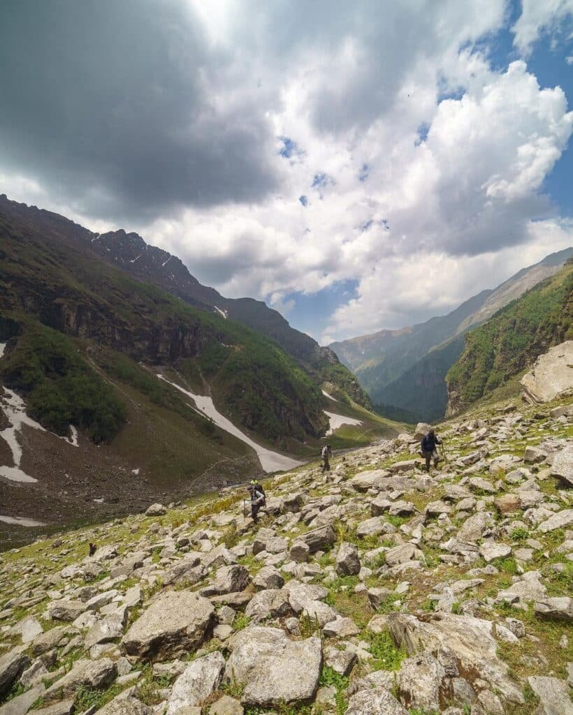
Rupin Pass is a high-altitude trek starting from Bawta in Himachal Pradesh and ending at Sangla in Himachal Pradesh. The trek is full of diverse natural phenomena, from sightings of majestic Himalayan ranges to waterfalls, glacial meadows, snow-covered landscapes, lush forests, charming little hamlets, and a hanging village, you get to experience nature at its finest. Being a high-altitude trek with scenic vistas, Rupin Pass is one of the most exhilarating trekking expeditions for all adventure enthusiasts. At every step of the trek, you will come across many surprises, and though at times you will have steep climbs the spellbinding views all around make up for the arduous hike
Rupin Pass is an ideal trek for any adventure as it offers a trek to every type of terrain, be it on snow, rocky terrain, along and through the water streams, or meadows. You will start trekking your route from greener and hot landscapes and move towards and through the coldest of areas over the snow as you reach the end.
Surprises on the trek
Waterfalls views: You will encounter many waterfalls and streams throughout the trek. The best of the sights you will face at Rupin Valley is thousands of waterfalls flowing down through such a height that it appears as if they are falling straight from the sky.
Jhaka Village, A Hanging Village: it is a uniquely positioned village at the utmost edge of the mountain making it appear to hang through the cliff.
Snow Bridges: The feeling of walking on the snow bridges you come across is another enhancement to the variety of the treks. You will come across numerous snow bridges on the trek.
Lush Forests: The trek at various places also passes through the forests of fir, Rhododendron & Oak. The entrance and exit to the forests are again so sudden that you will feel that it is a movie setup around you.
Kinnaur Temple: It is a two-story temple of Kinnauri culture at Sewa which is very different from its surrounding.
Views of Kinner Kailash: You will get mesmerized by the views of the lofty Kailash Peak while you reach the end of the Rupin Pass Trek .
Get engaged with TTH Team to make the best of this adventurous journey, we will ensure that no essential task is left out while taking care of your safety on the suddenly variably trek.
- Who can Participate
- Important Links
- How to Reach
- Trek Essential
Who Can Participate
Age; 15 years.
Experience of any high altitude trek, at least 1 treks of 4,000m/13,100ft.
The climber must be fit and have sufficient stamina to cover 5 km of distance in 30 minutes without stress.
The climber should be able to carry a 12-16 kg backpack.
Pulse rate at rest must be in between (60 to 90 beats per minute)
Blood Pressure Reading must be in between (DIASTOLIC 70 – 90, SYSTOLIC 100 - 140 mm Hg)
Respiratory rate at rest must be in between (12 to 20 breaths per minute)
Should not have Liver and kidney issues
Should not have Diabetes Mellitus, Bronchial Asthma, Heart problems, Hypertension etc
No pacemaker implant
People with the Sinus issues, Epilepsy please contact to trek coordinator before booking the trek
If your BMI is not normal, Please contact our Trek coordinator before Trek booking.
Medical & Disclaimer Form (Mandatory Documents) Click here to download Medical & Disclaimer Form
- Government Employees can avail the benefit of Special Casual Leave (SCL) when you join us for a trekking expedition. As per the rules of the Pay Commission, Special Casual Leave can be availed for up to 30 days in a calendar year for trekking/mountaineering expeditions through a registered organization. Trek The Himalayas is a registered adventure tour operator by Indian Mountaineering Foundation (IMF) and Ministry Of Tourism (MOT)
- Trekkers have to apply for leave at least 20 days before trek departure date,
- This service is exclusive to Indian government employees and is applicable only for treks within India.
- Do mail at info@trekthehimalayas to apply and mention your booked trek date and trek name.
Junior trekkers (below 15 years) should have a company of parents/guardians.
Trekkers between 15 to 18 years can come solo with the disclaimer form signed by parent/guardian.
- Medical & Disclaimer Form (Mandatory Documents) Click here to download Medical & Disclaimer Form
Exercise For Moderate to Difficult
Fitness Regime For:
Calculate Your Bmi
Your BMI value is
Congratulations, your body is in good conditions!
Arrival In Bawta
Our journey for Rupin Pass Trek starts from Bawta. You should reach Bawta one day prior to the trek. If you have booked your transportation from Shimla to Bawta with us, our team will pick you up from Shimla bus stand. You will driven from Shimla to Bawta from where we will start our trek next day. Bawta is a charming Himalayan hamlet located about 195 km from Shimla. Along the way, you will witness breathtaking views of nature and mountains. Keep your cameras on the ready because the scenery is going to be spectacular. On the way, you will pass the town of Rohru, a pleasant small town located on the banks of the Pabbar River. Rohru has the last ATM point post which there will be no cash withdrawal facility. From Rohru, you can see the road split in two - one leads to Janglik, the base camp for Buran Ghati Pass Trek and one leads to Bawta your base camp for Rupin Pass Trek .

Bawta to Jakha
Today you will be crossing the highest and the last village of this trek. Plus the trail will be continuous ascent for 4-5 hours. So embrace all the energy before beginning on the jaunt on the zig-zag mixed trail.
After a moderate ascent till Jiskun there will be a slight descending trail. You can find a wooden bridge between the dense forest. The route magically gets ascending in zig-zag fashion from the bridge. Refill your bottles at Selwan Khad as this is the last water point of today. Do not worry, there are many tea shops on the way for more water. Rest in your peaceful home stay at night.

Jakha to Dandreyash Thatch
Waking up at the campsite near Jhaka Village is sheer bliss. The trail is well defined, passes through the field of Jhaka village, and enters a forest where trees of fir stand tall depicting centuries old, pristine civilization. A turn in the trail past crossing the forest and landscapes changes itself to snow patches. Follow the snow bridge over Rupin, cross the bridge and walk on a narrow trail till another wooden bridge.
Half an hour more walk on the boulders and hoping through the streams flowing within the rocky paths along the left of Rupin, you will enter another forest, on which rest the Rhododendron trees of a different colour.
Another walk of a few kilometres and you are at Saruwas Thatch. Relax well and admire nature’s different shades on the perfect campsite, a serene u shaped valley in the middle of trees, with the sight of Rupin waterfall far away. Following this is the route filled with snow patches on the mountainside. The sacred silver birch trees (Bhoj Trees) will accompany you till the entrance of the forests. Move upwards through the forests and you will find yourself on the verge of U shaped valley. The enchanting sights from the lip of the valley, thousands of waterfalls rushing down below you are all set to hypnotize you for a movement.
Move downward to reach down to the valley through green and yellow meadows, after crossing a series of snow bridges, and you are in the middle of a valley, Dhanderas Thatch.
get ready to relax and then indulge in some fun activities organized by our to enjoy one of the most admiring and biggest known meadows of the Himalayan Range.

Dandreyash Thatch to Upper Waterfall
The altitude from Dhanderas to Upper Waterfall Camp is about 4000 meters which is enough to make you vulnerable to AMS. We shall take the necessary precautions to keep away from any altitude problems. Our team will also take a short session to teach you the skills of trekking in snow such as sliding on snow, sidestepping and cutting through the snow.
After proper acclimatization, you need to reach the base of Dhanderas, and from there, the trek crosses through many rivulets of Rupin. Make your way to the snow patch of the first waterfall through the marigold flowers. After a steady and careful walk on the rocks along the hill you can now see a trail going in between through the thick snow.
Your learned techniques will come is use as you have to cut your path to another vast snow bridge. This is the last but the ultimate snow bridge offering you the Rupin Water coming just above your head and getting down below your feet. A sharp but short climb after crossing the bridge and you are all set to get relaxed and enjoy your campsite.

Upper Waterfall to Ronti Gad, cross Rupin Pass
Longest trail of Rupin Pass begins with a steep ascent, with a bumper gain in altitude. An hour of climbing, then take left trail and discover totally different and amazing sights from the Rati Pheri campsite.
The only views from Rati Pheri are of the expanse of thick snow stretched all over, making your paths through them is your next exhausting task for the day to reach Rupin Pass Gully. We shall take utmost care here as the snow is very thick and the trails are not clearly defined. At Rupin Pass we will serve you with some refreshment to regain your energy for the next adventurous climb to Rupin Pass.
The trail to Rupin pass is short but very uncertain and has risks of loose stones falling from above. Our team will suggest you walk in line carefully putting your every step forward.
Rupin Pass cut from a hollow shaped region marks the beginning of Dhauladhar Range. A bit of descendant and you are ready to experience the next adventure to slide down the snow to reach Rukti Gad.
Way to Ronti Gad is a gentle walk followed by a sharp descendant. Camping at the coldest yet charming campsite amidst the mountains covered with snow.

Rest / Acclimatization / Buffer day
This day is a very important day of the trek, it greatly increases the chances of summit and this day cannot be ignored. This day can be used in any camp of the trek depending on the conditions at that time. Usually, it has been seen that many times trekkers get tired or the weather does not support, due to which it becomes necessary to rest for 1 day due to lack of time, there is a lot of difficulty in completing the trek, at that time this day helps us a lot and saves our planning from getting spoiled.

Ronti gad to Sangla & Drive to Shimla
Today’s trek will be a downward climb but very arduous as the trail’s altitude drops rapidly. Our team will take another round of bout to make you adaptable to the sharp descendant, climb your way downward with more ease without hurting your foot or knees.

Day-1: Arrival In Bawta
- Altitude: 2,350 m/ 7,700 ft.
- Drive Distance: 195 km | Duration: 8 to 9 hr.
- Pick Up Point: Old Shimla Bus Stand (Transportation is not included in the cost).
- Stay: Home Stay
- Last ATM Point at Rohru.
Day-2: Bawta to Jakha
- Altitude 2,750m/ 9,000ft.
- Trek 5 km, 4 hrs.
- Altitude Gain: 400m/1,300ft.
- Difficult level of ascent, steep climb
- Moderate ascent till Jiskun then descent till wooden bridge through forest and then zig-zag ascent till Jakha.
- Highest and the last village of Rupin pass trek
- Selwan Khad is the last water point..
- Tea and maggi shops are on the way.
- BSNL network is available.
- Hot lunch at camp site.
- Stay in home stay.
Day-3: Jakha to Dandreyash Thatch
- Altitude 3,550m/ 11,700ft.
- Trek:11 km , 8 hrs.
- Altitude Gain:800m/ 2,700ft.
- Easy but long walk.
- Most of the walk is along with the river.
- Can refill water bottles from the river.
- Enjoy the snow bridges and wild flowers.
- Trail surrounded by Silver birches (Bhoj trees), Rhododendrons (white, pink, purple).
- Packed lunch will be given.
- Stay in tent.
Day-4: Dandreyash Thatch to Upper Waterfall
- Altitude: 4050m/ 13,300 ft.
- Trek:5 km ,3-4 hrs.
- Can refill water from small streams.
- Most scenic day of the trek.
- Moderate level of ascent, continuously tricky climbing trail around the snow patches.
- Avoid getting on the snow patch directly.
- Meet the technical team they will give you important tips for the summit day.
Day-5: Upper Waterfall to Ronti Gad, cross Rupin Pass
- Altitude: Rupin Pass 4,700m/ 15,350ft; Ronti Gad 3,750m/ 12,300ft.
- Trek: 12 km, 10-11 hrs.
- Altitude Gain : 650m/ 2,050ft.
- Altitude Loss: 950m/ 3,050ft.
- Difficult Level of ascent. Longest and most exciting day of the trek.
- Steep ascent till the pass and then steep descend.
- 200 mtrs of very steep ascent known as Rupin Gully, just before the pass, give pass to porters and guides, let them go ahead.
- Leave camp site by 4:30 am.
- Carry enough hot water from the camp site, Water sources are limited.
- Reached Ronti gad late in the evening.
Day-6: Rest / Acclimatization / Buffer day
- Will be used as a rest, acclimatization or buffer day.
- This day can be used at any camp, depends on trekker’s fitness and weather.
- In general we use this day at Dandreyash Thatch camp.
Day-7: Ronti gad to Sangla & Drive to Shimla
- Altitude:2,650m/ 8,700 ft.
- Trek: 8 km, 4-5 hrs.
- 9-10hrs drive to Shimla.
- Moderate level of descent, continuously descent till Sangla.
- Many water taps on the way.
- Reach Sangla 1-2 pm.
- Cab leaves from Sangla at 3 pm and reached Shimla by 1 am (please make your hotel booking at Shimla accordingly).

- Mandatory Documents to Bring on A Trek Click Here.
How To Reach
It is essential for everyone to arrive at Shimla (06:00 am)
Meeting Place : Shimla old bus stand, Time : 6:00 AM
Once you have reached Shimla, TTH will manage the rest of your travel arrangements, if you have opted for TTH's pick-up service, you can select this option during the booking process by adding it as an add-on (book it at least 10 days before trek date)
It is advisable to reach Shimla a day before to avoid any kind of delays.
Options to reach Shimla
1 Take an overnight bus to Shimla, and then take a cab to the pickup point.
We always recommend going for the govt. Buses over the private ones outside the bus station as based on the experience we have found that there are very high chances of delay involved with private buses. Also, govt. Buses are always more reliable. Whichever bus you choose, just make sure to reach Shimla at least by 05:30 am.
2 Take a Train to Kalka and drive to Shimla. One can take the pleasure of a toy train, If you're arriving by Train, then come one day in advance.
3 Take a flight to Shimla airport (Jubbarhatti airport) (22 km, 50 min). If you're arriving by air, then come one day in advance.
If you prefer to travel independently, you can either take a government bus or book a private cab. Your trek coordinator will provide guidance on how to arrange for the bus or cab booking.
Arrive in Shimla by 11:00 pm.
The designated drop-off point is Shmila old bus stand.
Please arrange your hotel and make further bookings in Shimla accordingly.
TTH offers comfortable transportation through Tempo Traveler, Bolero, or equivalent vehicles. If you wish to upgrade your mode of transportation, please contact your trek coordinator for further assistance.

1. Accommodation (as per the itinerary):
- Homestay (dormitory with ground mattress.
- Camping (Twin sharing basis).
2. Meals (Veg + Egg):
- All meals from Day 1 Dinner to Day 7 breakfast as per the itinerary.
3. Support:
- 1 Versatile base camp manager: handles communication and deploys extra manpower in emergencies.
- 1 Mountaineering & First aid qualified professional trek Leader.
- 1 Experienced high altitude chef.
- Local experienced guides (Number of guides depending on the group size).
- Enough support staff.
4. Trek equipment:
- Sleeping bag, Sleeping liners (if required), Mattress, Utensils.
- 3 men all season trekker tent (twin sharing), Kitchen & Dining tent, Toilet tent.
- Camping stool, Walkie talkie.
- Ropes, Helmet, Ice axe, Harness, Gaiters & Crampon (if required).
5. First aid:
- Medical kit, Stretcher, Oxygen cylinder, Blood pressure monitor, Oximeter, Stethoscope.
6. Transportation (as per the itinerary):
- Transportaion from Shimla to Bawta & Sangla to Shimla.
7. Mules/porters to carry the central luggage.
8. Clock room facility available at the base camp for additional luggage.
9. All necessary permits and entry fees, Upto the amount charged for Indian.
10. Services from Shimla to Shimla.
Exclusion
1. Insurance (Mandatory).
2. Food during the transit..
3. Any kind of personal expenses.
4. Mule or porter to carry personal luggage.
5. Emergency evacuation, hospitalization charge or etc.
6. Anything not specifically mentioned under the head Inclusion.
Things can be provided on demand and availability (participant has to pay extra for these things).
1- Satellite phone/set phone - is a type of mobile phone that connects via radio links via satellites orbiting the Earth instead of terrestrial cell sites like cellphones. Therefore, they can operate in most geographic locations on the Earth's surface.
2- Gamow/PAC HAPO Bag (Portable Hyperbaric Bag) - is a unique, portable hyperbaric chamber for the treatment of acute mountain sickness (AMS), also known as altitude sickness.
3- AEDs (Automated External Defibrillators) - are portable life-saving devices designed to treat people experiencing sudden cardiac arrest, a medical condition in which the heart stops beating suddenly and unexpectedly.
Cancellation terms:
Cancellations prior to 25 days from the start of the Trip
Refund options
- 5% deduction of trek fee
- 100% cash voucher for any trip till one year
- Transfer your trek (any trek, any date) to your friend
Cancellation between 24 days and 15 days to the start of the Trip
- 30% deduction of trek fee
- 100% cash voucher for same trip till one year
- 85% cash voucher for any trip till one year
- Transfer your trek (same trek, any date) to your friend
Cancellation between 14 days and 10 days to the start of the Trip
- 50% deduction of trek fee
- 80% cash voucher for same trip till one year
- 70% cash voucher for any trip till one year
- Book the same trek, in the same season, with any other batch
Cancellation less than 9 days to the start of the trek
- No cash refund
- 20% cash voucher for the same trip till one year
- 10% cash voucher for any trip till one year
- Transfer your trek (same trek, same date) to your friend
Note- If a booking is made using a voucher or discount code, the policies related to vouchers and discounts cannot be modified.
In the unlikely event that TTH cancels a trek prior to the scheduled departure date:
While it is extremely rare for TTH to cancel a trek, we understand that unforeseen circumstances or natural disasters may occasionally require us to do so before the scheduled departure. These circumstances could include continuous rain or snow, thunderstorms, snowstorms, landslides, floods, earthquakes, or any other natural calamity that poses a risk to the safety of our trekkers. Additionally, unforeseeable events such as local riots, curfews, pandemics, lockdowns, government orders, or any similar situations that compromise the safety of the trekking experience may also necessitate a cancellation.
In the event of such a cancellation, TTH will provide you with a voucher equivalent to the amount you paid for the trek. This voucher can be redeemed for any of our treks within the next year, allowing you to still enjoy an adventure with us at a later date.
The issuance of a voucher is not applicable in situations where you are required to descend from the trek for any reason. The trek leader may make the decision to send you down from the trek due to factors such as insufficient fitness level, symptoms of Acute Mountain Sickness (AMS), high blood pressure, exceeding the designated turn-around-time, health concerns, or if you are found smoking, drinking, or violating the rules set for the trek. In such cases, the provision of a voucher does not apply.
In the rare event that TTH shifts a trek:
We would like to emphasize that weather conditions in high-altitude areas are highly unpredictable and can undergo sudden changes at any time, irrespective of the day. Additionally, circumstances beyond our control, such as natural disasters, political unrest, pandemics, and lockdowns, may impact the feasibility of conducting a trek. In cases where we are unable to proceed with an event due to such circumstances that are beyond our direct control, we will make every effort to provide you with an alternative trek that is safer and more suitable.
In such situations, we will issue a voucher to offset the cost difference between the originally scheduled trek and the alternative trek. This voucher can be redeemed at any time within one year from the date of issue. Please note that a refund fee or reimbursement of the cost difference is not applicable in these cases.
- Change of trek batch is dependent on the availability of seats in the batch
- In case of transferring a trek to a friend, he/she should satisfy all the mandatory requirements put forward by TTH
- TTH holds the right to change/cancel the policies, without prior notice
- Cash refund is applicable only in case of bookings made without using any promotional offer code or vouchers
Cash Voucher Terms:
- This is a non-transferable voucher
- The voucher cannot be merged with any other offer of Trek The Himalayas
- The voucher is valid for Trek booked directly with Trek The Himalayas in India
- To avail the voucher please use your register phone number or e-mail id
- All the other Terms of booking a trek with Trek The Himalayas are applicable to the voucher
- Trek The Himalayas holds rights to add/remove any of the Terms and Conditions without prior notice
Itineraries are based on information available at the time of planning and are subject to change. "Trek The Himalayas" reserves the right to change expedition dates, people or itineraries as conditions warrant. If a trip must be delayed or the itinerary changed due to bad weather, road conditions, transportation delays, government intervention, airline schedules, sickness, or other contingency for which TTH or its agents cannot make provision, the cost of delays and/or other changes are the responsibility of the participant. TTH reserves the right to decline, or accept, any individual as a trip member for any reason whatsoever.
Trek Essentials
PDF Of Trek Essential Download
Frequently Asked Questions(FAQ)
How to register/create an account with tth.
To register with TTH, visit our website - www.trekthehimalayas.com and create your account. To create your account you will need to use your email address and fill in all the details, set your unique password and your account is ready to use.
How to book a trek?
- To book a trek with TTH, you first need to register with us and create an account.
- Choose the trek that you want to do and click on available dates.
- You will land at the login page, fill in the required details.
- Add Participants, choose add-on services click on the Pay now button, choose your preferred payment method, and make the payment. TTH accepts multiple payment options, including credit/debit cards, net banking, and UPI.
- You will receive a confirmation email from TTH with all the necessary details about the trek, including the meeting point, transportation, accommodation, and other important instructions.
Made a payment but did not receive any confirmation.
please send an email to us at [email protected] or reach out to the numbers provided in the Help and Support section of your Trek Page. We will ensure that your issue is promptly resolved.
How to book off-load luggage and transportation?
To book services such as off-load luggage and transportation, you can find them listed as add-ons. These additional services can be booked at the time of your initial booking. If you miss booking add-ons during the initial reservation, you can log in anytime and easily book 4 days before the departure date add-ons through the platform.
If I have booked the wrong trek or date, how can I make changes?
In such a situation, please log in to your account and transfer your trek or date to the desired one within 12 hours or drop us an email at [email protected] 10 days before the departure date of the trek. After the initial 12-hour period, any changes will be processed according to the cancellation policy.
I am a beginner and confused which trek to book.
We recommend visiting our "Suggest Me a Trek" page. By filling out the form, our experts will contact you with the best possible trek options based on your preferences and experience level. Alternatively, you can reach out to us via email at [email protected] or give us a call using the numbers provided on our website for personalized assistance and recommendations.
How is family trek different from regular trek?
Family treks differ from regular treks by focusing on ease of difficulty, offering shorter durations for younger participants, Kid-friendly and easily digestible foods, child-friendly activities, maintaining a higher guide ratio for diverse age groups, and implementing additional safety measures for families.
Ideal treks for children.
Family Trek with Kids recommendation Only Dayara Bugyal and Chopta Chandrashila Trek.
Minimum age for children to trek with TTH.
Minimum age for TTH treks is typically 7 years, though this may vary depending on the specific trek.
Can we take children to high altitudes with their guardian?
Yes, you can take a kids to a high-altitude trek with a parent. Discuss with a trek expert before booking a trek.
Can we send kids without Parents/guardian?
Medical & Disclaimer Form (Mandatory Documents) Click here to download medical and disclaimer form
How to prepare a child for a high altitude trek?
Physical Fitness: Ensure your child is physically fit. Engage them in regular exercise, outdoor activities, and hikes to build stamina and endurance. Hydration: Emphasize the importance of staying hydrated at high altitudes. Encourage your child to drink water regularly, even if they don't feel thirsty. Proper Nutrition: Provide a well-balanced diet with sufficient carbohydrates for energy and foods rich in iron to prevent altitude sickness. Adequate Sleep: Ensure your child gets enough sleep in the days leading up to the trek. Quality rest is crucial for altitude adaptation. Educate on Altitude Sickness: Teach your child about the symptoms of altitude sickness, such as headache, nausea, and dizziness. Encourage them to communicate any discomfort immediately. Appropriate Clothing and Gear: Dress your child in layers to adjust to changing temperatures. Ensure they have appropriate trekking gear, including sturdy footwear. Positive Mindset: Foster a positive mindset. Encourage your child, and let them know it's okay to take breaks when needed. Medical Check-Up: Schedule a medical check-up before the trek to ensure your child is fit for high-altitude activities. Consult with a healthcare professional about any potential health concerns.
Kind of food will be served during the trek for children.
TTH takes special care to provide wholesome and nutritious food for children on treks. Here are some of the foods that are typically served for children: Breakfast: For breakfast, TTH serves a variety of options like porridge, cornflakes, bread, butter, jam, honey, boiled eggs, omelettes, and pancakes. Children can choose from these options to fuel themselves for the day's trek. Lunch: For lunch, TTH serves lunch which includes rotis, vegetables, rice, dal, and salad. The rotis are usually made fresh on the trek and are a good source of carbohydrates. The dal and vegetables provide protein and other essential nutrients. Snacks: TTH provides healthy snacks like fresh fruits, dry fruits, energy bars, cookies, and biscuits to keep the children energized throughout the day. Dinner: For dinner, TTH serves a hot and wholesome meal which includes soup, rice, dal, vegetables, and a non-vegetarian dish (if requested in advance). Children can also choose from a variety of desserts like custard, jelly, and fruit salad. Dietary requirements: If a child has any special dietary requirements, TTH can cater to those needs as well. For example, if a child is lactose intolerant or allergic to nuts, the kitchen staff can make arrangements to accommodate those requirements.
How to choose the right trek?
Choosing the right trek for a beginner can be a bit overwhelming as there are many factors to consider such as distance, elevation gain, terrain difficulty, weather, and time of year. Here are some tips that can help you choose the right trek for a beginner:
1. Determine fitness level: Assess the fitness level of the beginner to understand their physical capabilities. This will help you select a trek that is challenging but not too difficult.
2. Choose a well-traveled trail: A well-traveled trail will have more amenities such as signposts, water stations, and shelter. It is also safer as there will be other hikers on the trail.
3. Consider the length of the trek: For beginners, it is recommended to start with a shorter trek that can be completed in a day or two. This will help them get acclimatized to trekking and build their confidence.
4. Look for gradual elevation gain: Choose a trek with a gradual elevation gain rather than steep ascents. This will make the trek easier and more enjoyable.
5. Check the weather: Check the weather forecast before selecting a trek. Avoid treks during the monsoon season or winter when the trails can be slippery or dangerous.
6. Research the trail: Read about the trail to get an idea of the terrain, altitude, and difficulty level. This will help you select a trek that is suitable for the beginner.
7. Consult with an expert: If you are unsure about which trek to choose, consult our trek expert Mr. Nitin (+91 70600 59773) between 10 AM to 6 PM (Tuesday - Friday). Mr. Nitin will provide you valuable advice and guidance.
Overall, it is important to choose a trek that is enjoyable, challenging but not too difficult, and suitable for the beginner's fitness level and experience.
Can a beginner choose a tough trek?
It is not recommended for a beginner to choose a difficult Himalayan trek. Trekking in the Himalayas can be physically and mentally challenging, especially if you are not used to the high altitude, steep slopes, and rugged terrain. Choosing a difficult trek without the proper experience, fitness level, and preparation can be dangerous and put you at risk of altitude sickness, injury, and other hazards.
If you are a beginner, it is recommended to start with an easier trek and gradually build up your skills and experience. This will help you understand the challenges of trekking in the Himalayas, and also prepare you physically and mentally for a more difficult trek in the future. It is also important to choose a trek that matches your fitness level, experience, and interest.
What is the age limit for a beginner trekker?
There is no specific age limit for a beginner trekker. However, it is important to consider your physical fitness, health condition, and personal interests before embarking on a trek. Trekking in the Himalayas can be physically and mentally demanding, and requires a certain level of physical fitness and endurance.
If you have any pre-existing medical conditions or are above a certain age, it is recommended to consult with a doctor before embarking on a trek. It is also important to listen to your body and take breaks as needed during the trek to prevent exhaustion or injury.
If I am solo, can I join the trek in a group?
Yes, you can join the trek. We have fixed departure groups where you can simply book your trek and we will take care of curating a group.
How does my family get updated about my Trek?
Before you start the trek, it is recommended that you make all the necessary phone calls as during the trek you may or may not receive network coverage, once you come back to the Base Camp, you can reconnect with your family via phone once again. You can share your trek coordinator contact detail with your family members to get the latest updates about your trek batch.
What food can I expect?
At TTH, we provide wholesome and nutritious meals during the trek. The food is vegetarian and includes a variety of dishes such as rice, dal, vegetables, chapati, paratha, pasta, noodles, and soup. We also offer snacks such as biscuits, and salty, and dry fruits during the trek. Special dietary requirements such as vegan, gluten-free, or Jain food can also be arranged if informed in advance.
I am allergic to some foods.
If you are allergic to some foods, you need to let us know in advance so that we can make arrangements accordingly.
How safe is trekking with TTH?
TTH is a trekking company that prioritizes the safety of all its participants, including women trekkers. They have a comprehensive safety system in place, which includes a dedicated team of experienced and trained trek leaders and support staff who are equipped to handle emergency situations and provide first aid.
TTH also takes specific measures to ensure the safety and comfort of women trekkers. They have a separate tent accommodation for women trekkers, female trek leaders, and support staff. They also provide separate toilet facilities for women and encourage a safe and respectful environment for all trekkers.
Moreover, TTH has a strict policy against any kind of harassment and has a zero-tolerance policy towards such incidents. They have a designated Internal Complaints Committee (ICC) to investigate and address any complaints related to harassment or misconduct. Overall, TTH has a good reputation for safety and responsible trekking practices, and women can feel comfortable and safe while trekking with them.
How TTH will manage if I am the only woman in the group?
In case you are the only women in the group, we provide a single sleeping arrangement. Also, during the trek, the trek leader will always remain by your side to provide optimum safety and reassurance.
How can I know that other women are in the batch?
You can reach out to the trek coordinator to inquire about the number of female trekkers and their respective states who have booked the trek. Please note that the trek coordinator cannot disclose personal details of any trekker. Once you've confirmed your booking, a WhatsApp Group will be created for all the trekkers in your batch. This allows you to connect with fellow trekkers before the trek begins.
Can I know in advance, which trek is led by a women Trek Leader?
While many of our treks are led by female trek leaders, however, it is not possible to know which trek leader is assigned to which group. But nonetheless, whether the trek leader is male or female you can be completely assured of your safety and security with us.
Can I trek with periods? If yes, then where can I dispose of the sanitary pad?
Yes, it is possible to trek with periods. However, it is important to take some extra precautions and preparations to ensure a comfortable and safe trekking experience.
Here are some tips that can help you trek during your period:
1. Use menstrual hygiene products that you are comfortable with, such as tampons, pads, or menstrual cups. It is recommended to carry enough supplies for the entire duration of the trek.
2. Pack wet wipes, hand sanitizer, and plastic bags to dispose of used hygiene products.
3. Wear comfortable and breathable clothing that allows for easy movement and reduces friction. Avoid wearing tight or restrictive clothing that can cause discomfort.
4. Carry pain relief medication, such as ibuprofen or acetaminophen, in case of menstrual cramps.
5. Stay hydrated and maintain a balanced diet to support your energy levels and overall health.
6. Take breaks as needed and listen to your body. If you feel uncomfortable or experience any unusual symptoms, seek medical attention immediately.
It is also recommended to consult with a doctor before going on a trek during your period, especially if you have a pre-existing medical condition or are taking medication. By taking necessary precautions and being prepared, you can have a safe and comfortable trekking experience even during your period.
We provide proper disposal facilities for sanitary pad disposal during the trek.
How will the accommodation be during the trek?
We offer three person tents with twin-sharing for optimum comfort. A woman trekker will share a tent with another woman trekker and if you are the only woman in the group, you will be given a single accommodation for your comfort and privacy.
Are trek poles, Jackets and other equipment available for rent from Trek The Himalayas?
Yes, we do provide gears on rent. You can book it using you TTH account directly.
Who will be with us on the trek from Trek The Himalayas?
Mountaineering qualified Experienced and first aid certified Trek Leader, First Aid Certify local guide, Cook, helpers and supporting staff.
Who can not join the trek?
People suffering from Bronchitis, Asthma, High blood pressure, Epilepsy (got faints), TB , Heart problem or on higher BMI side are strictly not allowed to go on any Himalayan trek. Apart from this if you had any medical history, please let us know.
When it gets really cold can I consume alcohol?
No. Alcohol and smocking isn’t allowed while on trek. It is totally misconception that it will keep you warm. Your body need to acclimatize properly and for that eat properly and drink enough water; these things will keep you warm.
What type of toilet facility is TTH providing at the trek?
Toilet tents provide a convenient solution for answering nature's call in the great outdoors. Dry toilets, in particular, offer a highly sanitary approach. By digging a pit and utilizing mud and a shovel, you can easily cover up your waste. This method ensures cleanliness and hygiene while camping or exploring in the forest.
Remember to pack essential toiletries to complete your outdoor bathroom kit and maintain proper personal hygiene during your adventures. With these practices in place, you can enjoy nature while also respecting it.
How do I manage the negative temperatures on the trek at higher camps? Do I need special jackets?
Layer Up From Head To Toe Eat Full Meals, never sleep empty stomach You can keep warmee (if you’re more susceptible to cold). Use sleeping bag in right way and don’t leave free space in sleeping bag.
For upper body – Thermal layer – T-shirt (full-sleeves) – Fleece T-shirt (for extreme colds) – Fleece layer – Thick Jacket/Down Jacket – Waterproof or Windproof layer (outermost layer, when it is snowing or raining) - For Lower Body – Thermal layer – Hiking pants (normal) or Winter hiking pants
Based on how warm you feel you can skip any of the above layers. Your outer later should be windproof since it is windy at high altitude. The idea behind layering is that the more insulation you have the less cold you feel, and instead of wearing a very thick jacket if you wear multiple layers, your body will be better insulated against the cold.
Do you provide crampon/micro spikes and gaiters?
Yes, we provide micro spikes and gaiters, if required.
What documents need to carry on trek?
Mandatory documents: 2 xerox of ID having address (addhar card/driving license), 2 Passport size photographs, hard copy Medical form signed & sealed by doctor, disclaimer form sign by trekker and high altitude insurance.
If we come prior the trek date, Do you provide accommodation?
No. We don’t but we can suggest you good hotel/Stay nearby pick up location.
Do we get enough water for drinking?
Yes, trekker must carry 2 water bottles 1 litre each so they can refill it at campsite for drinking and keep themselves hydrate.
What kind of shoes we should buy for the trek?
You should buy shoes which has these three features –Good grip, Ankle Support and additional water resistant layers. Generally, we advise Quechua Trek 100, MH 500 and MH 100.
How do we get back after the trek?
Your return transport is also included in trek fee if you're opting for service Dehradun to Dehradun ; we use Tempo Traveller/ Tata Sumo/Max/Boloero kind of vehicle.
What happens if some members of the team need to turn back before the summit?
No one is forced to go on. There is always enough staff to split the party according to need and regroup later at the camp. Most people have no trouble reaching the highest campsite. If some members decide not to climb the final distance they can wait for the climbers to come back down the same way or take a lateral path to the descent route.
What kind of help is available in case of emergency?
We always have a first aid kit close at hand. Serious injuries are rare. Porters will assist injured climbers to the base of the mountain and onward to a clinic or hospital. Kilimanjaro International Airport is very near Marangu Gate if evacuation to the US or Europe is advisable.
What is Rupin Pass Trek?
The Rupin Pass Trek is a stunning journey through the lesser-known parts of the Indian Himalayas. The trail is filled with diverse landscapes, from dense forests of oak and rhododendron to high-altitude meadows and snow-covered slopes. The Rupin River is a constant companion on the trek, providing a soothing soundtrack as it rushes through the valleys. The highlight of the trek is undoubtedly the Rupin Pass , which sits at an altitude of 15,350 feet and offers panoramic views of the surrounding mountains. As you make your way up to the pass, the scenery changes dramatically, with the rocky terrain giving way to patches of snow and ice. The Rupin Pass Trek is a challenging trek that requires a good level of fitness and experience, but the rewards are well worth the effort. You'll have the chance to witness the raw beauty of the Himalayas and immerse yourself in the culture of the remote villages that dot the trail.
What is the best time to do Rupin Pass Trek?
The best time to do Rupin Pass Trek is during summer (mid-May to Jun) and autumn (Sep to mid-Nov) .
How difficult is Rupin Pass Trek?
Rupin Pass Trek is a difficult-grade trek.
What is the duration of the Rupin Pass Trek?
Rupin Pass Trek takes 7 days to complete the trek.
What is the starting point of the Rupin Pass Trek?
Rupin Pass Trek starts from Bawta village in Himachal Pradesh.
What is the maximum altitude reached during Rupin Pass Trek?
The maximum altitude of the Rupin Pass Trek is 15,350 ft .
What is the total distance covered during Rupin Pass Trek?
The total distance covered in Rupin Pass Trek is 41 km .
Is it necessary to have prior trekking experience for Rupin Pass Trek?
While it is not mandatory to have prior trekking experience for the Rupin Pass Trek , it is recommended that you have some level of fitness and experience in trekking. The Rupin Pass Trek is moderately difficult and covers an altitude of 15,250 feet, so it requires a good level of physical fitness and endurance. The trail includes steep climbs, rocky terrain, and narrow paths, so prior experience in trekking can help you tackle the challenges with ease. Moreover, the Rupin Pass Trek can be unpredictable, and the weather conditions can change quickly, so having prior trekking experience can help you adapt better to the challenges on the trail. However, with proper training and preparation, even first-time trekkers can undertake the Rupin Pass Trek and enjoy the stunning landscapes and cultural experiences along the way. It is always advisable to consult with a trekking company or a professional guide to assess your fitness level and discuss the requirements of the trek before embarking on the journey.
Is it safe to do Rupin Pass Trek?
The Rupin Pass Trek is generally considered safe, but like any high-altitude trek, it comes with its share of risks and challenges. However, with proper preparation, precautions, and guidance, you can minimize the risks and ensure a safe and enjoyable trek.
One of the main risks on the Rupin Pass Trek is altitude sickness, which can affect trekkers at high altitudes. It is important to acclimatize properly and stay hydrated to avoid altitude sickness. Trekking companies usually follow a well-planned itinerary with gradual altitude gain to help trekkers acclimatize properly.
It is always advisable to undertake the Rupin Pass Trek with a reputable trekking company or an experienced guide who can provide guidance and support throughout the journey. Moreover, it is important to follow safety guidelines and instructions provided by the guide or trekking company to ensure a safe and enjoyable trek.
What are the essential items to carry for Rupin Pass Trek?
Here are some of the essentials you should carry for the trek:
1. Trekking shoes: A good pair of trekking shoes is essential for a comfortable trek. Make sure your shoes are well-fitted, sturdy and provide good grip on the trail.
2. Warm Clothing: The weather can be unpredictable in the mountains, so it's important to carry warm clothing, including thermal innerwear, fleece jackets, down jacket, and waterproof jacket.
3. Trekking pants: Carry comfortable and quick-drying trekking pants that are suitable for the weather conditions.
4. Backpack: A good quality backpack with a capacity of 40-50 liters is ideal for carrying your essentials during the trek.
5. Sleeping bag: A good quality sleeping bag is essential for a comfortable stay during the camping nights.
6. Headlamp/Flashlight: Carry a good quality headlamp or flashlight with extra batteries for trekking during early morning or late evening hours.
7. Water bottle: Carry a reusable water bottle and stay hydrated throughout the trek.
8. Snacks: Carry energy bars, dry fruits, and snacks for instant energy during the trek.
9. First aid kit: Carry a basic first aid kit, including band-aids, antiseptic cream, pain relief spray, and medicines for altitude sickness.
10. Sun protection: Carry sunscreen lotion, sunglasses, and a hat to protect yourself from the harsh sun rays.
11. Trekking poles: Trekking poles can help in maintaining balance and reduce the strain on your knees while trekking.
What is the highest point of the Rupin Pass Trek?
The highest point of the Rupin Pass Trek is the Rupin Pass at an altitude of 15,350 ft .
- Date and Price

Rent A Gear
Trek Articles
Trek Stories
Quick Links
Trekking & Hiking
Mountaineering
Multi Sports
Himalayan Pilgrimage
Website Privacy
Terms & Condition
Contact Info
Get in touch with us. E-mail us Monday-Saturday (10 AM to 6 PM)
Address: Trek The Himalayas, Kaintura Plaza, Badrinath Road Tapovan, Rishikesh - 249201 Uttarakhand
Phone: 8191004846
Email: [email protected]
2010 Trek The Himalayas. All rights reserved

Rupin Pass Trek
A surprise in scenery every hour
Dates Full? Check out the Buran Ghati trek View details
An equally stunning and high-adventure trek View details
TREK DIFFICULTY
Moderate-Difficult
TREK DURATION
HIGHEST ALTITUDE
If there is a trek in India that surprises you at every turn, it has to be the Rupin Pass trek. This trek is like an orchestra, building momentum with surprises in scenery every hour. You’ll never see it coming. Allow us to take you through the trek.
To begin with, Rupin Pass is a high altitude mountain pass, climbing to 15,250 feet. The adventure and thrill of ascending to such an altitude in the Indian Himalayas makes it a terrific trek on its own. And then come the surprises.
The surprises begin even before the trek, on your drive from Rohru over the Chainsheel Pass. Unpaved roads wind uphill through forests, changing views by the minute. The forest is so unique that you will want to step out of your vehicle now and then to admire it. At around 11,000 feet, you burst out of the forests into grasslands. These grasslands stretch far and wide. They last until you reach the Chainsheel Pass.
This is just a precursor to the trek.
On the first day of your trek, the hanging village of Jakha, perched on a ridge, takes you by surprise. The next day, the sudden appearance of the tall and dark coniferous forest about an hour outside Jakha is jaw-dropping. The abrupt end of the forest and the sudden appearance of a snow bridge below you (if early in the season) are equally mind-boggling.
We are yet to get to Day 2, where the islands of Saruwas Thatch and a sudden view of the famous Rupin Waterfall catch you by surprise. Even though you have heard the waterfall is tall, its sheer 1,500 ft drop takes you by surprise.
The perfectly “U” shaped glacial valley of Dhanderas Thatch, with hundreds of waterfalls streaming down, make you marvel at how such formations naturally exist. The following day, climbing to the top of the Rupin waterfall over its numerous snow bridges is unexpected. Then, out of the blue, you get to the upper waterfall campsite, with the Rupin river calmly gliding alongside your camp.
After a long climb from the upper waterfall camp, you step into the vast snowfields of Rata Pheri. It is an alpine setting that is least expected.
From the edges of Rata Pheri, the first sight of the Rupin gully leaves you in awe, accompanied by an adrenaline rush. When you realise you have to climb the gully to get to the pass, it is an adventure that trekkers least expect.
The climb to the knife-edged Rupin Pass, the vast slides on the snow after that, and the long grassy descent to the last Ronti Gad campsite are new surprises on the other side.
The Rupin Pass trek is so full of quick scenery changes that it leaves trekkers breathless until the end. Only when you reach the road at Sangla, do the surprises finally end.
Count the sudden scenery changes as you do the Rupin Pass trek. It is a unique combination of high-altitude adventure with stunning changes in scenery —a combination so rare that it makes the Rupin Pass one of the top treks to do in India.
Rupin Pass Videos
Watch these videos to prepare well for your trek.
Rupin Pass - Complete Trek Information
We have always wanted trekkers to be well-informed before they go on a Himalayan trek. Knowledge is the difference between a safe trek and a dangerous one. It’s also the difference between a wholesome experience and a superficial experience.
Use this section to learn about the Rupin Pass trek. It has in-depth information about each day of the trek, what to expect, and how you need to prepare for it. Many years of expertise have gone into this content.

Quick Itinerary
Get your trek plan

How Does Each Day Look
Complete Day-Wise Guide With Photos

How Difficult is the Rupin Pass Trek
And how fit should you be?

Best Time to do the Rupin Pass Trek
Plan your trek accordingly

How To Reach the Base Camp
Plan your travel

Packing List
Things you must take on the trek

Why get fit for Rupin Pass Trek
Fitness matters for the trek

Frequently Asked Questions
Get your questions answered here
Photo Gallery

Surprises on the Rupin Pass Trek
10 surprising twists on the rupin pass trek.
A change in scenery at every turn
1 . Drive through Chainsheel Valley
The surprises on the Rupin Pass start even before the trek starts. The drive from Rohru to Jiskun passes through the Chainsheel Valley. Not many understand how unique and mind-boggling this drive is. It’s like a trek in fast-forward. You drive past dense rhododendron forests and then into the lush meadows that stretch for miles in front of you. Imagine driving right in the middle of such a landscape.
To add to this, you drive almost at 11,000 feet , at the height of Dhanderas Thatch (11,700 ft) on Rupin Pass trail. In fact, you can even see Dhanderas Thatch from a point on this drive!

A glimpse of how picturous the drive through Chainsheel Valley is. Photo by Jothiranjan
2 . The Hanging Village of Jakha
Stepping past the post office of the Jiskun village, peer straight ahead and high up in the horizon. A cluster of houses, marking a village hangs out of the mountainside – so incredulous, that it takes time for you to fathom how a village can hang from the walls of a mountain. The village is Jakha , also commonly called the hanging village.

If there is a trek in Himachal so rich in the ancient culture of the place, it has to be Rupin Pass. Photo by Jothiranjan
3 . Fir forests after Jakha
Half hour outside Jakha village, the trail flattens out and plunges into a fir forest , so sudden that it is almost like a gate has opened up. Pine trees over 100 feet tall tower over the trail. And within the enchanting forest Maple trees play hide and seek. The forest ends as suddenly as it starts over a confluence of the Rupin with a tributary.

The dark, deep fir forest of Rupin Valley is one to cherish. Photo by Vishwas Krishnamurthy
4 . Buras Kandi and Saruwas Thatch
Later, past Udaknal and just past Buras Kandi , around a bend in the trail a sight leaves you gaping. Rhododendrons bloom everywhere and climb a thousand feet into the slope. It is a riot of colours: pink, violet and white Rhododendrons – all of the dwarf kind. Some of the Rhododendrons even swoop over the clear waters of the Rupin, their flowers falling into the river to be carried downstream forever. After Buras Kandi you enter Saruwas Thatch , which is another sight in itself. With bursts of yellow flowers and bees buzzing around them, it i a sight to behold!

Buras Kandi is home to dwarf rhododendrons of almost all colours. It's a treat to your eyes! Photo by Jothiranjan.
5 . The first view of the Rupin Waterfall
After a while, stepping over the roots of the Rhododendrons, the trail suddenly tunnels into a view of the U-shaped Rupin glacial valley . In the far distance, at the end of the valley, is the famous three stage Rupin waterfall. It appears to be falling from the clouds.

The first sight of Rupin Waterfall is a stunning sight that leaves you in awe. Photo by Antara Naik
6 . The Glacial Valley around the Rupin Waterfall
Soon after Saruwas Thatch , the trail climbs over a bump to suddenly stand on the lip of the glacial valley. The sight in front is straight out of a picture book. The Rupin flows gently, slowly through the middle of the greenest meadow that you have seen. On the sides of the valley, snow patches stick to the valley walls.

The glacial U shaped valley around the Rupin Waterfall is a wonder in itself. Photo by Jothiranjan
7 . Snow bridges in the valley
If you are trekking in summer, look out for the snow bridges that you have to cross on your way to the lower waterfall camp site (Dhanderas Thatch). Snow bridges are common on slopes but to see them on a wide open valley is a surprise.

snow bridges are natural marvels that you rarely come across on any other trek. Photo by Jothiranjan
8 . The Upper Waterfall Campsite
Getting to the upper water fall camp site is a series of switchback climbs over the three water falls (and many on snow bridges and patches). Climbing the final ridge, the Upper Waterfall campsite is unlike any place you have seen before. It is a large basin where icy flanks of mountains surround it. Below the flanks snow melts to form hundreds of little streams that join together to form the Rupin.

Upper waterfall campsite where you see the origin of Rupin river. Tirth Bhatt
9 . The Gully to Rupin Pass
The final climb to the Rupin pass is through a gully. In the narrow snow laden gully voices echo and reverberate through its confines – something that is new to most trekkers.

Crossing the Rupin Gully is one of the most adventurous day on the Rupin Pass trek. Photo by Vishwas Krishnamurthy
10 . The Kinner Kailash Ranges on the other side of the Pass
Getting out of the Ronti Gad campsite on the Sangla side, the trail descends harmlessly along over meadows, when a sudden bend on the trail brings you face to face with the towering summits of the Kinner Kailash ranges .

As you get on to the other side of the Rupin Pass, you start seeing the Kinner Kailash range. Photo by Gajendra Kumar

Expert Speak
Arjun Majumdar, Founder, CEO

Arjun Majumdar, the Founder of Indiahikes, went on the Rupin Pass trek much before he started Indiahikes. He is a veteran of the trekking community in India and one of the earliest to trek Rupin Pass and put it on the maps of our country. Here’s Arjun talking about the trek full of surprises.
What I Like and Don’t Like About the Rupin Pass Trek
What I Like About Rupin Pass
1 . The adventurous pass crossing
The Rupin gully is a half tube cut out of the mountainside. When you first see it from the trail, the sight of the near-vertical climb is enough to make your heart stop. (A sentiment even our staff and Trek Leaders attest to – despite having done this trek multiple times!).
The climb is 200 meters, on a steep snowy flank through narrow rocky confines of the mountain. As finding a foothold in this terrain is difficult, our staff will cut steps for you on the hard ice. As you climb, placing your foot on these steps – you find that voices echo and travel sharply all over the gully. This climb is as thrilling as it gets!

The Rupin Pass crossing is one of the most adventurous pass crossings in the Himalayas. Picture by Lomesh Gururaj
2 . The Lower waterfall campsite
The lower waterfall campsite is probably one of the most exquisite Himalayas have to offer. Snuggled at the bottom of a perfect “U” shaped glacial valley – it lies on the bed of a lush green meadow. From your view at the bottom of the meadow, snow-patched cliffs tower on all three sides.
In front, the Rupin cascades down from the snowy Dhauladhar range for over two thousand feet to form the famous Rupin waterfall. Spending two days at this campsite is a luxury!

The Lower Waterfall Campsite. Picture by Arthy
3 . The grasslands on the Kinnaur side
From the snowline after the pass, the trail descends sharply through endless meadows that stretch to Sangla Kanda. The Ronti Gad campsite is amid these grasslands. Towering, snow-capped mountains lean over the campsite and a bountiful stream flows along with the camp.
This is a gift after a long pass day! The meadows of Sangla Kanda are awe-inspiring, especially in its setting. The sharp serrated edge of the Kinnaur Kailash range, all over 20,000 ft, overlooking the meadows of Sangla Kanda is enough to make you stand still in amazement.

The meadows of Sangla. Picture by Vivek Bagade
5 Reasons Why Indiahikes
When we brought out new trails in Indian trekking, safety came with us. Back in 2012, we were the first to introduce microspikes, and two years later, pulse oximeters became standard thanks to us. Nobody does safe treks like Indiahikes. In the mountains, emergencies don't care who you're with – everyone knows that when trouble hits, you look for the yellow tents of Indiahikes.

We are pioneers in trekking. Since 2007, we have brought out treks that have become India's most famous treks: Roopkund, Rupin Pass, Buran Ghati, Kedarkantha, Kashmir Great Lakes, Tarsar Marsar, Brahmatal, Phulara Ridge—the list goes on. In 2023 alone, we brought out five new treks in Indian trekking. We know treks better than anyone . This comes directly from the reason why Indiahikes was born: to bring out trek information and enable trekkers to trek on their own.

More than 25,000 people trek with us every year. We are the largest trekking organisation in India. 24% of our trekkers come back to trek with us every year. Over 4,000 students from the top educational institutions trek with us every year. Aside from this, families with children choose to trek with Indiahikes knowing that our treks are the safest. We have taken over 8000 children trekking so far, and the number continues to grow.

We focus on designing transformative experiences. Our trek leaders conduct thought-provoking exercises that help you reflect and contemplate. This impact stays with you for a long time. Trekkers return feeling energised, more confident, or developing abilities to deal with difficulties. Many have changed careers, rethought their core values, become more humble, shown gratitude to others, or started a new fitness journey.

Since 2012, we have pioneered sustainable practices that have become standard in trekking. Using eco-bags, our trekkers have cleared over 120 tonnes of litter from the mountains. We do not carry packaged foods; instead, we serve freshly made food. We do not light campfires; we carry coal to light angethis to keep you warm. Our bio-toilets not only keep our toilets odour-free but also enrich the soil. When you trek with us, you leave mountains better.
Indiahikes Features
You’re guarded with our trek again philosophy

If you are unable to complete a trek, or if you love a trek, you can repeat it with us anytime. You don’t have to pay us for it. See our thoughts behind this here .
Daily 3-time health checks keep you safe at any altitude
Our thrice-a-day oxi-metre checks keep altitude sickness at bay, never allowing you to reach a point where you need evacuation.
Join any group, they are all women-friendly groups

With around 30% of our trekkers being women, all women, including those travelling solo are comfortable to join any of our groups.
Request Jain/Vegan-friendly food
Our kitchen teams understand your needs as a vegan (or a Jain). We will take special care of your food, even in the remote Himalayas.
Be comfortable and sustainable with bio toilets
We have specially designed bio toilets to ensure you have no sight or smell in toilets, at the same time making sure the toilets cause no harm to the fragile ecosystem we trek in.
Fresh, nutritious food at every camp
We’ll admit it. Our love for food surpasses our love for minimalism. Expect freshly cooked, multi-cuisine food at all camps, designed to meet your nutritional requirements and keep your taste buds happy!
Other Treks Like Rupin Pass

Georgia Atsunta Pass Trek
Get Trek Info

Buran Ghati Trek

Pin Bhaba Pass

Georgia Atsunta Pass...
The flower bouquet trek of Georgia

A Grand Buffet Of India's Greatest Treks

The Most Dramatic Crossover Trek in India
Sign up for our much loved Weekly Mailer
We have terrific trekking tips, trek updates and trek talks to look forward to
Treks by Categories
Treks by season, treks by month, treks by duration, treks by difficulty.
- Easy - Moderate
- Moderate - Difficult
Treks by Region
- Uttarakhand
- Himachal Pradesh
- Lahaul and Spiti
- Jammu & Kashmir
- West Bengal
- Chhattisgarh
Treks by Experience
- Family Treks
- Stargazing Treks
- Senior Treks
- Adventure Therapy
- Summer Camps
- Youth Camps
- Cancellation policy
- Work with us
- Our sustainability practices
- Privacy Policy
- Terms & Conditions
080 468 01269 Mon to Sat - 9.30 AM to 7.30 PM Sun - 9.30 AM to 6.30 PM
Bengaluru Office
139, Defence Colony Road, Defence Layout, Sahakar Nagar, Bengaluru, Karnataka 560092
Dehradun Office
No.85/10, Neshvilla Road, Dehradun - 248001
© 2024 Indiahikes Private Limited
All images are copyrighted by their respective authors.
- Trekking & Travel Events
- Travel Organizations
- Himalayan Treks
- Maharashtra Treks
- Karnataka Treks
- Travel Guides
- Weekend Getaways
- Trekking Tips & Advice
Rupin Pass Trek: Unleash the Thrill of the Himalayas
- Trekking Destinations
Welcome to the breathtaking world of the Rupin Pass Trek, an exhilarating adventure that takes you through the stunning landscapes of the Himalayas.
This high altitude trek is a true gem for adventure enthusiasts, offering a perfect blend of natural beauty, adrenaline-pumping challenges, and a sense of accomplishment.
In this article, we will cover all the details, covering the trekking itinerary, the best season to do the trek, budget & cost, how to reach the starting point, highlights of the trek and FAQs for a successful expedition.
- Max Altitude: 15,250 Ft. (4,650M)
- Average Trekking Fees: ₹14,000 – ₹16,000
- Distance: 37 – 45 kms
- Difficulty: Moderate-Difficult
- Duration: 7 days
- Ideal For: Experienced Trekkers Only
- Best Season: Mid April – June & September - Mid November
- Region: Himachal Pradesh
Table of Contents
Rupin Pass Trek: An Overview

The trek is a thrilling and picturesque adventure in Himachal Pradesh . It takes you through a diverse and stunning landscape, showcasing the raw beauty of the mountains. The trek starts from the village of Jiskun and concludes in Sangla, Himachal Pradesh.
The journey begins with gentle ascents through charming villages, terraced fields, and dense forests of oak, rhododendron, and pine. As you gain altitude, the scenery transforms into breathtaking alpine meadows, cascading waterfalls, and glacial valleys. One of the trek’s highlights is the mesmerizing Rupin Waterfall, a magnificent sight.
The trail becomes more challenging as you approach the Rupin Pass, situated at around 15,250 feet (4,650 meters) . The final ascent involves negotiating steep slopes, boulders, and snow patches. However, the efforts are rewarded with awe-inspiring panoramic views of the mountains, including the majestic Kinner Kailash range.
The descent from the Pass leads to the Sangla Valley, known for its apple orchards and traditional Himachali villages. The trek ends in Sangla, where you can immerse yourself in the local culture and relish the scenic beauty.
The Rupin Pass trek is moderately difficult , requiring good physical fitness and prior trekking experience. It is perfect for adventure enthusiasts seeking a thrilling and rewarding experience amidst the pristine Himalayan wilderness.
Additional Information for the Rupin Pass Trek

Trekking Difficulty & Duration
The trek is considered moderately difficult and suitable for experienced trekkers. It involves traversing challenging terrains, steep ascents, and negotiating boulders and snow patches. Prior trekking experience and good physical fitness are recommended to fully enjoy and successfully complete the trek.
The trek typically ranges from 7 to 8 days , depending on the itinerary and the pace of the trekking group. The trek covers a distance of approximately 37 – 45 kilometres from Jiskun in Uttarakhand to Sangla in Himachal Pradesh.
Each day, trekkers cover an average distance of 5 to 10 kilometres (3 to 6 miles), with varying levels of ascent and descent. The duration of each day’s trek can range from 5 to 8 hours , depending on the fitness level of the trekkers and the prevailing weather conditions.
It’s important to note that the trek involves camping in remote locations with basic facilities and limited access to amenities. Trekkers must be prepared for variable weather conditions, including cold temperatures and possible rain or snowfall.
Overall, the trek offers a challenging yet immensely rewarding experience for adventure enthusiasts, allowing them to immerse themselves in the stunning landscapes and natural beauty of the Indian Himalayas.
Best Time For the Rupin Pass Trek
The trek is best undertaken during two distinct seasons: Mid-April to June (Summer) and September to Mid-November (Autumn) . Both seasons offer unique experiences and stunning landscapes, catering to different preferences.
During the summer, from mid-April to June, the trek is characterized by pleasant weather, blooming rhododendrons, and vibrant meadows. The trail is adorned with colourful flowers and lush greenery, creating a picturesque setting. The temperatures during this time range from mild to moderately cold , with daytime temperatures averaging around 10 to 15 degrees Celsius . However, it’s important to note that occasional rainfall can be expected during the summer months, so proper rain gear is essential. The summer season is ideal for those who enjoy the sight of vibrant flora, comfortable trekking conditions, and moderate temperatures .
On the other hand, the autumn season, from September to mid-November, offers a completely different charm. The weather becomes cooler, and the landscapes transition into hues of gold and orange as the leaves change colour. The autumn season is known for its clear skies, providing breathtaking views of the surrounding peaks. The temperatures can vary significantly, with daytime temperatures ranging from 5 to 15 degrees Celsius . Autumn is a great time for trekkers who prefer cooler temperatures, clearer views, and a quieter experience .
Both seasons have their own allure and advantages, and their choice depends on personal preferences. Whether you prefer the vibrant summer blooms or the crisp beauty of autumn, the trek promises a memorable adventure amidst the awe-inspiring Himalayan landscapes.
Budget & Costing for the trek

The budget and cost for the trek can vary depending on several factors, such as the type of accommodation, mode of transportation, food preferences, and personal expenses. Here’s a breakdown of the average expenses involved:
- Trekking Fees: The average trekking fees charged by organizations for the trek typically range from ₹ 14,000 to ₹ 16,000 . This fee usually includes services such as experienced guides, camping equipment, meals, and permits.
- Transportation: The cost of transportation to reach the starting point of the trek, Jiskun, needs to be considered. This can include expenses for flights or buses/trains to Delhi or Chandigarh and further transportation to Jiskun via Shimla. The budget for transportation can vary depending on the mode of travel and distance covered.
- Accommodation: During the trek, accommodation is mostly in tents or basic guest houses in villages along the route. The cost of accommodation is generally included in the trekking fees.
- Food and Water: Most trekking packages include meals during the trek. However, if you prefer to carry your own food or have dietary restrictions, it is advisable to budget for additional food expenses. Similarly, budgeting for packaged drinking water or water purification methods is essential.
- Equipment and Gear: If you do not have trekking equipment, you may need to rent or purchase gear such as trekking shoes, backpacks, sleeping bags, and jackets. Consider these costs if required.
- Miscellaneous Expenses: It is recommended to keep some extra funds for unforeseen expenses, snacks, personal medication, and tips for the trekking staff.
Remember, the trek budget can vary based on individual preferences and requirements. Researching and comparing prices from different organizations and planning accordingly to ensure a comfortable and enjoyable trekking experience is advisable.
How To Reach?

To reach the start point of the trek, which is Jiskun, you can consider the following transportation options:
- Flights: The nearest airports to Jiskun are Delhi and Chandigarh. You can book a flight to Delhi’s Indira Gandhi International Airport (DEL) or Chandigarh’s Chandigarh International Airport (IXC). From there, you can take a taxi or bus to reach Shimla, which is approximately 190 kilometres away from Jiskun. Flights to Delhi or Chandigarh can be accessed from various cities within India and internationally.
- Local Buses: From Shimla, you can take a local bus to Jiskun. Shimla is well-connected by road, and regular buses ply between Shimla and other major towns and cities in the region. You can check the timings & availability of the buses from the Shimla Bus Stand or inquire at local transportation offices.
- Trains: You can train to Kalka Railway Station in Haryana if you prefer train travel. You can board the famous UNESCO World Heritage Kalka-Shimla toy train from Kalka, which offers a scenic journey to Shimla. Once in Shimla, you can proceed to Jiskun by local bus or taxi.
Upon reaching Shimla, arranging transportation to Jiskun in advance is advisable, either by booking a private taxi or checking for shared cabs or buses. Consider the travel time and road conditions while planning your journey to reach the start point of the trek.
Detailed Itinerary for the Rupin Pass Trek

Day 1: Bawta Village to Jhaka (5 kilometres, approximately 5-6 hours)
The trek begins from Bawta village, and the trail takes you through scenic landscapes and charming villages. The trek to Jhaka, also known as Dhaula, is relatively easy and covers a distance of 8 kilometres. It will take around 5 to 6 hours to reach Jhaka, where you will camp for the night.
Day 2: Jhaka to Saruwas Thatch (8 kilometres, approximately 6-7 hours)
In today’s leg of the trek, trekkers descend towards the Rupin river, enjoying the mesmerizing sight of its crystal-clear blue waters. The landscape transitions from dense fir forests to occasional snowy patches. Crossing a snow bridge and a wooden bridge, one must carefully navigate boulders and streams, immersing ourselves in the enchanting beauty of a diverse rhododendron-filled forest.
Day 3: Saruwas Thatch to Dhanderas Thatch (3 kilometres, approximately 2-3 hours).
On this day, the trail gradually ascends to Dhanderas Thatch, passing through vast meadows and crossing a river. The distance covered is around 7 kilometres, taking approximately 4 to 5 hours. Camp overnight at Dhanderas Thatch.
Day 4: Dhanderas Thatch to Upper Waterfall Camp (5 kilometres, approximately 3-4 hours)
The trek from Dhanderas Thatch to Upper Waterfall Camp is shorter but involves steep ascents. You’ll witness the majestic Rupin Waterfall along the way. The distance covered is around 6 kilometres, taking approximately 3 to 4 hours. Camp overnight at Upper Waterfall Camp.
Day 5: Upper Waterfall Camp to Rupin Pass to Ronti Gad (10 kilometres, approximately 8-10 hours).
This is the most challenging and rewarding day of the trek. You’ll ascend to the Rupin Pass at approximately 15,250 feet (4,650 meters). The trek covers a distance of 14 kilometres and takes around 8 to 10 hours. Enjoy breathtaking panoramic views from the pass and descend to Ronti Gad for overnight camping.
Day 6: Ronti Gad to Sangla (12 kilometres, approximately 5-6 hours).
The final day involves a descent through beautiful forests and scenic landscapes. The trek covers a distance of 12 kilometres, taking approximately 5 to 6 hours. Reach Sangla, where the trek concludes, and bid farewell to the stunning Himalayan region.
Please Note: This is a general itinerary, followed by most of the trekking groups in India. However, there might be slight differences in the itinerary depending on the trekking group you opt to go with.
Highlights of the Rupin Pass Trek
Breathtaking Scenic Landscapes
Be mesmerized by the stunning scenic landscapes at every step. The trek offers a diverse and breathtaking visual feast, from snow-capped mountains to lush green meadows, cascading waterfalls, and dense forests.
Challenging Terrain and Thrilling Crossings
Prepare yourself for an exhilarating adventure as you navigate through challenging terrains. The trek involves crossing snow bridges, wooden bridges, boulders, and streams, adding a thrilling element to the journey. Each crossing brings a sense of accomplishment and excitement.
Rupin Waterfall – Nature’s Majestic Spectacle
One of the standout features of the trek is the magnificent Rupin Waterfall. Witness the awe-inspiring sight of water cascading down from great heights, surrounded by the pristine beauty of the Himalayas. The grandeur of the waterfall leaves trekkers in awe and creates unforgettable memories.
Rich Biodiversity and Flora
Experience the vibrant biodiversity of the region as you trek through forests adorned with a wide variety of flora. The trek is particularly famous for its vibrant rhododendron forests, which explode with colours during the blooming season, creating a picturesque landscape.
Spectacular Summit at Rupin Pass
Reach the pinnacle of the Rupin Pass and get awarded with breathtaking panoramic views of the surrounding peaks and valleys. The summit is approximately 15,250 feet, offering a sense of accomplishment and a truly unique vantage point.
Cultural Immersion in Remote Villages
Along the trekking route, encounter the warm hospitality of the remote villages in the Himalayas. Interact with locals, experience their unique culture, and gain insights into their way of life, adding a cultural dimension to your trekking adventure.
The trek encapsulates the essence of an exhilarating and awe-inspiring Himalayan adventure, leaving trekkers with memories that will last a lifetime.
Essential Gear and Equipment
Before embarking on the trek, it is essential to pack the right gear and equipment to ensure a safe and comfortable journey. Here is a list of items you should consider carrying:
- Trekking shoes with good ankle support
- 45L trekking Rucksack with rain cover
- Trekking gaiters
- Warm and waterproof clothing layers
- Sleeping bag suitable for sub-zero temperatures
- Trekking poles for better stability on uneven terrains
- UV-protected sunglasses and sunscreen
- Water bottles and water purification tablets
- Headlamp or flashlight with extra batteries
- First aid kit with essential medications
- Portable power bank for charging electronic devices
Safety Tips & Precautions
While embarking on any trek, safety should always be a top priority. Here are some essential safety tips to keep in mind during the Sar Pass Trek:
- Trek with experienced trek leaders and follow their instructions.
- Stay hydrated and carry an adequate supply of water.
- Pack light and carry only the essential items.
- Dress in layers to adapt to changing weather conditions.
- Respect the environment and maintain cleanliness.
- Inform someone about your trekking plans and expected return.
- Stay updated about weather conditions and local regulations.
- Avoid alcohol and smoking during the trek.
- Make sure if you are doing it on your own to carry emergency oxygen cylinders.
Embark on the Rupin Pass trek and discover an unforgettable adventure through breathtaking landscapes. Each step unveils nature’s splendour, from snow-capped peaks to vibrant rhododendron forests.
Traverse challenging terrains, cross mesmerizing rivers, and witness the majesty of the Rupin Waterfall. Reach the summit of the Rupin Pass, where panoramic views reward your efforts.
Immerse yourself in the awe-inspiring beauty of the Indian Himalayas, forging memories to last a lifetime. The Rupin Pass trek is an experience that will leave you in awe of nature’s wonders.
Rupin Pass trek is considered moderately difficult, suitable for experienced trekkers.
Rupin Pass is famous for its stunning natural beauty, picturesque landscapes, and the thrilling adventure it offers to trekkers.
Rupin Pass trek is a multi-day Himalayan adventure that takes you through remote villages, lush forests, snow-capped peaks, and a challenging high-altitude mountain pass.
Rupin Pass trek is not recommended for beginners. It requires prior trekking experience and good physical fitness due to its challenging terrain and steep ascents.
Video of the Rupin Pass Trek
Kuari Pass , Bhrigu Lake , Brahmatal Trek , Sar Pass Trek , Shrikhand Mahadev Trek , Buran Ghati Trek , Bali Pass Trek , Kareri Lake Trek , Kashmir Great Lakes Trek , Tarsar Marsar Trek
Did you like this trek guide for the Rupin Pass trek?
We have 100s more such guides on similar off-beat experiences & we send out such guides, offers, hidden gems, and trekking destinations weekly via email. Subscribe to our newsletter to get them directly into your inbox.
- trekking guides
- No comments yet.
Add a comment
Leave a reply · cancel reply.
Your email address will not be published. Required fields are marked *
This site uses Akismet to reduce spam. Learn how your comment data is processed .
- Share via...

Best Crossover Trek in Himalayas
Rupin pass trek 2024.
May, June, Sept, Oct
₹14999+ 5% GST
“not all those who wander are lost.”, rupin pass trek, via dhaula/jiskun, dhaula/jiskun to sangla, transportation cost (to be paid on the spot), shimla to jiskun/ddn to dhaula, sumo:12000 (5-6 persons), tempo: 14000 (11-12 persons), sangla to shimla, sumo: 11000, tempo: 16000.
+ Rs. 3500 Backpack Offloading + Rs. 330 Outdoor Insurance
Difficulty Level - 6
uttarakhand & himachal - 7 days - 44 km, batches: august 2023, up to 15% off in may-jun batches for a limited period ✨.
The Rupin Pass Trek is a popular trekking route in the Uttarakhand region of India, which takes trekkers through some of the most beautiful and diverse landscapes in the Himalayas. The trek starts from the picturesque village of Dhaula and follows a trail through lush forests, meadows, waterfalls, and high-altitude passes, offering stunning views of the surrounding mountains and landscapes.
The trek is typically completed in 7 to 8 days and covers a distance of around 52 kilometers. The highest point of the trek is the Rupin Pass, which is located at an altitude of 4,650 meters (15,252 feet). The trek is considered moderate to challenging, and it is recommended for experienced trekkers with good fitness levels and prior experience of trekking at high altitudes.
The best time to do the Rupin Pass Trek is from mid-May to mid-June and from mid-September to mid-October when the weather is pleasant, and the trails are accessible. However, it is worth noting that the weather can be unpredictable in the Himalayas, and trekkers should be prepared for occasional rain or snowfall.
Itinerary (Dhaula to Sangla)
Here's a detailed itinerary for the Rupin Pass Trek:
Day 1: Dehradun to Dhaula (1,550m) - 210km, 9-10 hours - Start early from Dehradun and reach Dhaula by late evening - Overnight stay in tents or guesthouse
Day 2: Dhaula to Sewa (2,300m) - 12km, 6-7 hours - Trek through the beautiful forest trail alongside the Rupin River - Cross the hanging bridge over the river and reach Sewa - Overnight stay in tents or guesthouse
Day 3: Sewa to Jiskun (2,700m) - 11km, 6-7 hours - Trek through the dense forest trail and reach the small hamlet of Jiskun - Enjoy the stunning views of the surrounding mountains and landscapes - Overnight stay in tents or guesthouse
Day 4: Jiskun to Udaknal (2,950m) - 10km, 6-7 hours - Trek through the scenic trail alongside the Rupin River and reach the beautiful meadow of Udaknal - Overnight stay in tents
Day 5: Udaknal to Dhanderas Thatch (3,500m) - 10km, 5-6 hours - Trek through the steep and challenging trail to reach the high-altitude meadow of Dhanderas Thatch - Overnight stay in tents
Day 6: Dhanderas Thatch to Upper Waterfall Camp (4,200m) - 6km, 4-5 hours - Trek through the rocky and rugged terrain to reach the upper waterfall campsite - Overnight stay in tents
Day 7: Upper Waterfall Camp to Rupin Pass (4,650m) to Ronti Gad (3,800m) - 12km, 8-9 hours - Early morning start to cross the Rupin Pass, the highest point of the trek - Trek down to Ronti Gad campsite through the beautiful meadows and streams - Overnight stay in tents
Day 8: Ronti Gad to Sangla (2,680m) - 14km, 7-8 hours - Trek down to the quaint village of Sangla through the beautiful Kinnaur Valley - End the trek and drive back to Shimla or onward destination
Note: The itinerary is subject to change depending on weather and trail conditions.
Itinerary (Jiskun to Sangla)
Here's a detailed itinerary for the Rupin Pass Trek starting from Jiskun and ending in Sangla:
Day 1: Jiskun to Udaknal (2,950m) - 10km, 6-7 hours - Trek through the scenic trail alongside the Rupin River and reach the beautiful meadow of Udaknal - Overnight stay in tents
Day 2: Udaknal to Dhanderas Thatch (3,500m) - 10km, 5-6 hours - Trek through the steep and challenging trail to reach the high-altitude meadow of Dhanderas Thatch - Overnight stay in tents
Day 3: Dhanderas Thatch to Upper Waterfall Camp (4,200m) - 6km, 4-5 hours - Trek through the rocky and rugged terrain to reach the upper waterfall campsite - Overnight stay in tents
Day 4: Upper Waterfall Camp to Rupin Pass (4,650m) to Ronti Gad (3,800m) - 12km, 8-9 hours - Early morning start to cross the Rupin Pass, the highest point of the trek - Trek down to Ronti Gad campsite through the beautiful meadows and streams - Overnight stay in tents
Day 5: Ronti Gad to Sangla (2,680m) - 14km, 7-8 hours - Trek down to the quaint village of Sangla through the beautiful Kinnaur Valley - End the trek and drive back to Shimla or onward destination
Note: The itinerary is subject to change depending on weather and trail conditions. It is recommended to have a guide or trekking company to ensure safety and proper navigation on the trail.
What's Included
Food as per menu on the trek (Starting Dinner on Day 1 till Packed Lunch on Day 8)
Exhaustive First Aid kit including Oxygen cylinder
Forest Permits/Camping Charges, if any (Upto the amount charged for Indian nationals)
Dome tents - on twin sharing basis, Sleeping bags, mats
Micro-spikes, Gaiters, Helmets, if required
Trek guide, cook, helpers, and porters for carrying common supplies
Mountaineering course certified Trek Leader with First Aid certification along with special rescue course from NIM, Uttarkashi
What's Not-Included
Portage of personal bags during the trek
Cost of any kind of Travel Insurance.
Any Expense of personal nature.
Any Expenses not specified in the inclusions list.
Essentials to carry
If you're planning to go on an expedition to Kalindi Khal, which is a high-altitude trek in the Indian Himalayas, here are some essential things that you should carry with you:
Trekking Gear: Good quality trekking shoes, trekking poles, backpack, and headlamp with extra batteries.
Clothing: Warm, comfortable, and lightweight clothing that is suitable for high-altitude trekking. This includes thermal wear, a fleece jacket, windcheater, raincoat, trekking pants, gloves, and a hat.
Sleeping gear: A good quality sleeping bag that can withstand sub-zero temperatures, and a sleeping mat or inflatable mattress.
First Aid Kit: A well-stocked first aid kit with essential medicines for high-altitude sickness, pain relief, diarrhea, and other common ailments.
Food and Water: Carry sufficient food and water for the entire trek, and carry a water purification system or tablets to purify water from streams and rivers.
Navigation equipment: Maps, compass, and GPS device.
Sun Protection: Sunglasses, sunscreen, and lip balm.
Personal Items: Camera, phone, power bank, toiletries, and any personal medication that you might need.
Emergency Supplies: Emergency whistle, rope, knife, and a firestarter.
It is always recommended to do proper research and take advice from experienced trekkers or tour guides before embarking on a high-altitude trek like Kalindi Khal.
Footwear Non-skid, deep-treaded, high-ankle trekking shoes Qty -1 Pair of light weight Slipper/Sandals Qty -1
Is the Rupin Pass trek difficult?
Yes, the Rupin Pass trek is considered to be a moderately difficult trek. The trek involves a steep ascent to the Rupin Pass at an altitude of 4,650m and a steep descent on the other side, which can be challenging for some trekkers. The trail also involves crossing streams, walking on narrow ridges, and trekking through rocky and rugged terrain. Therefore, it is recommended to have prior trekking experience and be physically fit before attempting this trek. However, with proper preparation and guidance, the Rupin Pass trek can be a rewarding and enjoyable experience.
What months can you trek Rupin Pass?
The Rupin Pass trek is usually open for trekkers from mid-May to mid-October. During these months, the weather is relatively stable, and the trail is free from snow, making it easier to navigate. However, it is advisable to check the weather forecast and trail conditions before planning the trek, as weather patterns can be unpredictable in the mountains. The best time to trek Rupin Pass is between June to September, as the weather is usually clear, and the trail is in its best condition during this period.
What is the total distance of the Rupin Pass trek?
The total distance covered in the Rupin Pass trek is approximately 52 kilometers or 32 miles. The trek starts from Dhaula in Uttarakhand and ends in Sangla in Himachal Pradesh. The trek is spread over 5-7 days, and trekkers usually cover a distance of 7-12 kilometers per day, depending on the itinerary and trail conditions. The Rupin Pass trek involves a steep ascent to an altitude of 4,650 meters and a steep descent on the other side, which can be physically challenging. However, the trek offers spectacular views of the Himalayas, waterfalls, forests, and meadows, making it a memorable and rewarding experience.
Rupin Pass Trek
Duration : 7 days 6 nights, the price : ₹ 10,500.00, max people : 20, age range : 18.
The Rupin Pass trek in India is a journey that constantly astonishes and captivates with its ever-changing landscapes. It’s akin to an enchanting symphony, with each leg of the trek revealing a new and breathtaking surprise. Let’s take you on this remarkable adventure.
To start, Rupin Pass stands tall at an elevation of 15,250 feet, promising an exhilarating experience in the Indian Himalayas. Yet, the true magic lies in the unexpected wonders that unfold along the way.
The journey begins even before you set foot on the trekking trail, during the drive from Rohru via the Chainsheel Pass. As you wind your way up unpaved roads through dense forests, the scenery transforms with every turn, offering a feast for the eyes. The uniqueness of the forest may compel you to pause and admire its beauty. Around 11,000 feet, you emerge from the forests into vast grasslands that stretch as far as the eye can see, an enchanting sight that lasts until you reach Chainsheel Pass.
This is just a prelude to the awe-inspiring trek ahead.
On the first day of the trek, the hanging village of Jakha, nestled on a ridge, takes you by surprise. The following day, you’ll be left awestruck by the sudden appearance of the towering, dark coniferous forest about an hour’s walk from Jakha. The forest abruptly gives way to a snow bridge below (if you’re trekking early in the season), a sight that boggles the mind.
But hold on, we’re only getting started. On Day 2, the picturesque Saruwas Thatch and a breathtaking view of the renowned Rupin Waterfall await your discovery. Despite hearing about its height, the sheer 1,500-foot drop of the waterfall takes you by surprise.
As you traverse the perfectly “U”-shaped glacial valley of Dhanderas Thatch, with numerous waterfalls cascading down, you can’t help but marvel at the wonders of nature. The next day, as you climb to the top of the Rupin waterfall using its many snow bridges, the unexpected adventures continue. Suddenly, you find yourself at the upper waterfall campsite, with the tranquil Rupin River flowing beside your camp.
After a strenuous ascent from the upper waterfall camp, you’ll find yourself in the expansive snowfields of Rata Pheri, an alpine setting you’d least expect.
Standing at the edges of Rata Pheri, your first glimpse of the Rupin gully will leave you in awe, accompanied by an adrenaline rush. When you realize that you must ascend this gully to reach the pass, it becomes an adventure you never anticipated.
The climb to the knife-edged Rupin Pass, the thrilling slides on the snow afterward, and the long descent through lush grasslands to the final Ronti Gad campsite are all unexpected surprises on the other side.
The Rupin Pass trek is a whirlwind of ever-changing scenery that leaves trekkers breathless until the very end. It’s only when you reach the road at Sangla that the surprises come to a close.
Count each sudden shift in scenery as you embark on the Rupin Pass trek. It’s a rare blend of high-altitude adventure and stunning landscape changes—a combination so extraordinary that it ranks the Rupin Pass among the top treks to experience in India.
Transportation Cost: Rs 10,500 per Bolero vehicle (split among trekkers), expected arrival in Shimla around 1 am on the 8th Day.
Optional: Return cab from Sangla Kanda for an additional Rs 3,500 (inform Trek leader a day before the last day).
Please note: Distances between campsites and altitudes may vary slightly due to weather conditions and chosen routes.
Here are some important points to keep in mind for the Rupin Pass trek:
Accommodation: You’ll stay in a lodge at Jiskun and Jakha, while the rest of the days during the trek will be in tents (with three people sharing per tent).
Document Requirements: It’s essential to have a copy of your photo ID for entry at forest check posts along the trek route. Given that photocopying facilities may be limited in Jiskun, please ensure you have this document ready in advance. These documents will be part of the Safety Check-in conducted by the trek leader upon your arrival at the base camp.
Cloakroom Facility for Excess Luggage: We offer a cloakroom service at the Rohru base camp for storing extra luggage. The cost is Rs 200 per 10 kg bag. Anything exceeding 10 kg will be considered as second luggage and will incur additional charges. After completing the trek, your cloakroom-stored luggage will be returned to you in Rampur.
Here’s a concise itinerary for the Rupin Pass trek:
Check out Rupin Pass Trek Images .
Schedule Details
Day 1: rohru to jiskun (7,630 ft).
Drive Distance: 85 km
Drive Duration: 5 hours
Pickup Point: Hotel Lok Sewa Grand (near Rohru ISBT)
Pickup Time: 9:00 am
Alpha Hikers Basecamp: Jiskun
Transportation Cost: Rs 6,500 per Bolero vehicle (split among trekkers)
Cloakroom and rental procedures at 8:00 am.
Day 2: Jiskun to Jakha
Trek Distance: 4 km
Trek Duration: 4 hours
Altitude Gain: 7,630 ft to 8,755 ft
Highlights: Challenging trek, one-hour descent followed by a steep ascent.
Day 3: Jakha to Saruwas Thatch
Trek Distance: 7.10 km
Trek Duration: 5-6 hours
Altitude Gain: 8,755 ft to 10,770 ft
Highlights: Beautiful fir forest, Rupin River banks, dwarf rhododendrons.
Day 4: Saruwas Thatch to Dhanderas Thatch
Trek Distance: 3 km
Trek Duration: approx. 2 hours
Altitude Gain: 10,770 ft to 11,700 ft
Highlights: Short and scenic day, meadows, and the iconic Dhanderas Thatch campsite.
Day 5: Dhanderas Thatch to Upper Waterfall
Trek Distance: 2.4 km
Trek Duration: 2-3 hours
Altitude Gain: 11,700 ft to 13,275 ft
Terrain: Snow bridge (summer) or rocky and sometimes slippery terrain (autumn).
Day 6: Upper Waterfall Camp to Rupin Pass, then Ronti Gad
Trek Distance: 7.4 km
Trek Duration: 9-10 hours
Altitude Gain and Loss: 13,275 ft to 15,279 ft to 13,005 ft
Highlights: Adventurous day, early start, steep ascents, Rupin Gully, challenging descent.
Day 7: Ronti Gad to Sangla. Drive to Shimla
Trek Distance: 11.9 km
Trek Duration: 6 hours
Altitude Loss: 13,005 ft to 8,660 ft
Drop-off Point: Shimla Old Bus Stand
Highlights: Steep descent to Sangla, picturesque lush grasslands, trek ends at River Baspa.
Got a Question?
- Do not hesitate to give us a call. We are an expert team and we are happy to talk to you.
- +91-9990205353
- [email protected]
Home » Shop » Rupin Pass Trek
- getting there
- detailed itinerary
- Cost inclusions
- Cancellations
- 1 Week trek
- Garhwal Treks
- Himachal Pradesh
- Kinnaur Treks
- Moderate Grade Treks in Himalayas
- Summer Treks
- Uttarakhand
Rupin Pass Trek:
Upcoming Rupin Pass trek starting on 4th June 2022.
When you think of a high altitude trek in summer, Rupin pass trek is not to miss. There are several passes which connect the Baspa valley of Kinnaur to the Garhwal in south. Once these passes were used by shepherds and traders rather than using the circuitous Hindustan-Tibet road in present days. The route offers wide range of landscape, altitude and gradient. Initially the trail is inside the Govind National Park (Govind Vanya Pashu Vihar) and passes through Oak and Fir forests , interior villages in the river valleys at lower elevation while beautiful meadows (referred as Thach in local language), alpine wild flowers, waterfalls, steep ice fields on higher altitude. The route is typically rich in wild flowers, specially just after monsoon. Famous Brahma Kamal flourish in abundance in the surrounding areas of the pass. During summer, the trail above the meadows remain covered in heavy snow. In monsoon the snow melts and the shepherds cross for grazing opportunities. From the pass there are spectacular views of Kinnaur Kailash range and other peaks of Charang Ghati ridge. The other side of the pass i.e. Kinnaur is famed for its “Golden Delicious” apple orchards.

Brief Itinerary for Rupin pass trek:
Day 1: Drive from Dehradun to Dhaula – 200 Km by car – 10 hours Day 2: Trek to Sewa – 10 Km – 5/6 hours Day 3: Trek to Jhaka – 12 Km – 6/7 hours Day 4: Trek to Buras Kandi – 7 Km – 5 hours Day 5: Trek to Dhanderas Thatch (Lower Waterfall) – 6 Km – 4 hours Day 6: Trek to Rati Pheri/Upper waterfall – 5 Km – 4 hours Day 7: Trek to Sangla Kanda over Rupin Pass – 12 Km – 8/9 hours Day 8: Trek to Sangla – 4 Km – 2 hours
*** Trekkers need to reach on their own to Dehradun on Day 1 morning (by 7 am) or the previous night. You will reach Sangla by early afternoon on Day 8. It is advised that you book your return tickets from Delhi on Day 10 morning or later. Transportation cost to reach Dhaula and return from Sangla are not included in the TREK FEE. ***
Rupin pass trek – Altitude and Distance profile graph:
Below is a graphical representation of the altitude and distance of major points on Rupin pass trek trail.

Best time/Seasons for Rupin Pass trek:
As all high altitude treks in the Himalayas (apart from few trans Himalayan treks), Rupin Pass trek also can be done best in two seasons. One being in summer before monsoon and the later being post monsoon in fall.
Summer (May/June): Starting from early May to end of June. Because of the residual snow of winter expect moderate to heavy snow during this time. You will get snow from lower waterfall camp in patches and above. Due to heavy snow normally Rati Pheri camp is not possible this season but upper waterfall will be the highest camp before Rupin pass. The nature of snow will be icy/slushy as it melts during daytime and refreezes again in the night. Micro spikes/anti-slip grips (don’t get confused yourself with mountaineering crampons) are helpful. Also you will in love with Rhododendrons in summer. These blooms in abundance around Buras Kandi (Buras means Rhododendron in local language). So, if snow is your priority then this is your season. Brief showers in the afternoon is a normal occurrence.

Post monsoon (Sep/Oct): Traditionally this is the best window for any high altitude pass on the Himalayas. After monsoon the weather becomes clear and haze free. September is typically greener and you will get the meadows (called Thatch in local language) at their best. Variety of flowers bloom in monsoon and remain till late September. Most revered Brahma Kamal bloom on the higher rocky ridges. From October the grass will turn into golden and it will become colder. Also there will be chance of fresh snowfall on high altitude above 14000 ft. Experienced hikers who have already been to snow treks and don’tt have any special liking for snow normally prefer this season.

Rupin valley, its people and culture:
Rupin pass trail is all about following the Rupin river from Dhaula (at Dhaula Supin and Rupin forms Tons river, the main tributary of Yamuna) to its origin. Following upstream you will not only witness its twist and turn but also cross very interior villages of Uttarakhand (up to Sewa village) and then villages of Himachal (Jiskun and Jakha). The architecture of their houses and attires have similarities with Kinnaur region. Most of the people at Jiskun and Jakha are of Satsangi religious sect and are pure vegetarian.

Access to Rupin pass trek base (Dhaula):
Based upon your request we will arrange a pick up and drop from Dehradun to Dhaula. This will be shared equally by the team members on actual basis. You pay directly to the driver/transporter. The fare is Rs 6000 for a Tata Sumo/Mahindra Maxx/Bolero one way. This can accommodate 6 to 8 people. A Tempo Traveller charges Rs 9000 (12-14 seat) one way. This is NOT included in the TREK FEE.
While returning from Sangla either one can take the overnight bus to Shimla at 5 pm or board the bus next morning at 8 am. The 235 Km journey will take 10 to 12 hours. From Shimla there are frequent bus services for Chandigarh and Delhi.
Return from Sangla (trek end point) to Shimla/Chandigarh/Delhi:
Rupin pass trek ends at Sangla. You should reach Sangla latest by noon on Day 8, starting from Sangla Kanda. Some trekkers start their return journey on the same evening whereas few prefer to stay back at Sangla for the night. The last village on Baspa valley is Chitkul, which is 25 Km further up from Sangla. Here are the different options which you can avail:
1) There is a state transport HRTC operated bus starts in the afternoon/evening (4/5 pm) and reaches Shimla in 10/12 hours. From the same bus terminus you will get busses for Chandigarh and Delhi which will take 4 and 9/10 hours respectively.
2) If you prefer to stay the night at Sangla (there are plenty of accommodation options) then you can avail the next morning HRTC bus ( at 6 am) directly going to Delhi (ISBT Kashmiri Gate) via Shimla. This will take around 18/20 hours.
3) At times trekkers take a reserved vehicle from Sangla to Shimla on Day 8 evening or Day 9 morning. Our team will help you to get one. This will be shared equally by the availing team members and a Tata Sumo charges around 7000/8000 Rs.
To reach the trek base Dhaula independently/public transportation check the details in GETTING THERE TAB.
Click here to view the List of Things to carry in Rupin Pass trek
Why treks with ht.
Duration: 7 days of trekking from Dhaula to Sangla over Rupin pass; Dehradun to Sangla in 8 days. Add another full day to return to Delhi via Shimla.
Prerequisite: One or two prior Himalayan trekking experience is advised. Heavy to moderate snow in pre monsoon. Trekkers must be in good physical condition to endure sustained walk and climbs.
Grade: Moderate
Physicality: 7 /10
Trail Length: 60 Km
Highest Point: Rupin Pass ~ 4685 m/15370 ft
Seasons: May/June (summer/pre monsoon) & September/October (Post Monsoon/Fall)
Further Option: There are other trekking passes like Borasu Pass, Lamkhaga Pass, Nalgan Ghati, Shinkha Ghati (Lamea Pass) which connect western Garhwal to Kinnaur in Himachal Pradesh. It is possible to do a round trip while reaching Sangla and returning through another pass to Garhwal.
Access: Trek starting point (trek base) is Dhaula, 200 Km from Dehradun.
Rail station: Dehradun (Station Code: DDN)
Airport: Delhi; Nearest airport at Jolly Grant, 20 Km from Dehradun (Code: DED)
Upcoming scheduled dates for Rupin Pass trek:
- You can check the scheduled Fixed Departure dates in the calendar available inside Booking Form or inside REGISTER NOW form. Tour starting Dates are highlighted as per our itinerary ( Day 1 of 8 days itinerary ).
- At present BOOK NOW functionality is disabled . You can get all the information in your email by submitting the REGISTER NOW form.
- If you are a group of people and available dates are not matching then you may select Custom date mode (by clicking the Select your custom date) and fill in the displayed form.
- You can also check all the available dates at a glance in our TREK CALENDAR .
- Trekkers need to reach Dehradun on Day 1 morning (latest by 7 am) or the previous night. Return to Shimla on Day 9 evening (around 7 pm). Arrange your tickets for inward journey and return accordingly.
How to reach Dhaula (The trek base):
Nearest Rail station: Dehradun (Station Code: DDN)
Nearest Airport: Delhi, Jolly Grant in Dehradun (Airport Code: DED)
Based upon your request we will arrange a pick up and drop from Dehradun to Sankri and back. This will be shared equally by the team members on actual basis. You pay directly to the driver/transporter. The fare is Rs 6000 for a Tata Sumo/Mahindra Maxx one way. This can accommodate 6 to 8 people. A Tempo Traveller charges Rs 9000 (12-14 seat) one way. This is NOT included in TREK FEE and to be paid directly to the driver/owner.
If you wish to reach our Trek Base Dhaula on your own by public transportation:
- There are 2/3 privately operated buses from Dehradun (near DDN railway station on Gandhi road) To Sankri. The 200 Km journey will take around 10/12 hours. The busses start at 5:30/6/7 am. You need to get down at Netwar and then hire a cab for last 10 Km.
How to reach Dehradun:
For the treks at Uttarkashi district in Garhwal , one has to reach the capital city of Uttarakhand, Dehradun, specially the trek starting from Sankri, Yamunotri etc. Haridwar, Rishikesh and Dehradun are 3 nearby cities in the area and one can move from one to another by public vehicles like bus or shared Jeeps.
For more options to reach Haridwar you can check here .
Haridwar to Dehradun: 55 Km and may take one and half to 2 hours.
Dehradun to Rishikesh: 45 Km and may take around one and a half hour.
You can fly or by train reach New Delhi as per your convenience from any part within India.
There are direct trains from Kolkata to Dehradun.
KUMBHA EXPRESS – Train No. – 12369 ( Very good option to reach Haridwar by 5 pm; You can take a bus from the terminus just opposite to the railway station referred as Roadways bus stand/ISBT and reach Dehradun in one and half hour. Spend the night in Dehradun and start your onward journey by car next morning.)
UPASANA EXPRESS – Train No. – 12327 ( Very good option to reach Dehradun directly by 5 pm; Spend the night in Haridwar and start your onward journey by car next morning)
DOON EXPRESS – Train No. – 13009 ( Don’t book this train when you plan a long onward journey immediately in the morning)]
Avoid booking wait listed (WL) tickets in AC classes (1A/2A/3A) or Chair Car (CC). Book Sleeper class (SL)/Second Sitting class (2S) tickets which have normally more seats/berths and hence much better chance to get confirmed.
You can reach Dehradun easily from New Delhi by train or bus (~ 6/7 hours) and is around 260 Km.
Following trains are good to reach Haridwar and run daily.
DDN JANSHTBDI – Train No. 12055 (Arrives DDN in the evening @ 9:10 pm, good choice when you stay the night in Dehradun and have a long drive ahead next day) NANDA DEVI EXP – Train No. 12205 (arrives DDN early morning @ 5:40 am)
Always avoid booking wait listed (WL) tickets in AC classes (1A/2A/3A) or Chair Car (CC). Book Sleeper class (SL)/Second Sitting class (2S) tickets which have normally more seats/berth and hence much better chance to get confirmed.
Govt. Road Transport (Roadways of Uttarakhand, Uttar Pradesh, Delhi, Haryana, Punjab etc.) buses are frequently available in day time and night from Kashmiri Gate ISBT ( http://www.delhi.gov.in/wps/wcm/connect/doit_transport/Transport/Home/ISBT/Fare+Chart ). Tickets are available on board for these regular type buses. From Delhi Airport or Station you can reach ISBT Kashmiri Gate via Delhi Metro service ( http://www.delhimetrorail.com/metro-fares.aspx ). It is only 4 Km from NDLS and can be reached easily by booking an auto rickshaw.
For privately operated bus, you can book online from different portals. Select a boarding point suitably. Overnight Volvo/A.C/Push back buses are available. Normally these buses take up to 7 hours to reach Dehradun ISBT. You can book an auto rickshaw for Railway Station (5 Km away)/Hotel Drona (GMVN) or take a shared auto (Route No. 5) from ISBT.
[There are two major bus terminus in Dehradun. The buses from Delhi/Haridwar goes to the ISBT (Inter State Bus Terminus) and the other one is the Parvatiya Depot (Hill Depot, from where you can get the buses going up the hills like Uttarkashi, Barkot, Purola etc) located just beside the Railway station.
Nearest Airport Jolly Grant is 25 Km away from Dehradun. book a private taxi to reach Dehradun city. This airport is accessed from Dehradun, Haridwar and Rishikesh easily. The flights are mostly via Delhi.
For night stay in Dehradun:
Trekkers reaching on the previous day before the journey to the actual trek base need to stay the night in Dehradun. There are several options in Dehradun for spending a night while staying in Premium, Standard or Budget accommodation. Options vary from Privately operated Hotels/Lodges, to state run Tourist Rest Houses.
State run GMVN (Garhwal Mandal Vikas Nigam) operates Hotel Drona complex is 10 minutes walking from the railway Station. You can book an auto rickshaw. From ISBT it is around 5 Km. You can book an auto rickshaw to Hotel Drona (GMVN) or take a shared auto (Route No. 5) from ISBT (Inter State Bus Terminus). This is a reliable and a decent choice for Standard accommodation. The have restaurant and room service. Check the following for online booking of the above: http://www.gmvnl.com/newgmvn/tour/booktrh.asp You can call or visit GMVN nearest office or even send an email for more information.The information is available at: http://www.gmvnl.com/newgmvn/online_reservation/#
Return from Sangla:
Drive to dhaula: 200 km - 10/12 hours, trek to sewa: 10 km - 5/6 hours, trek to jhaka: 12 km - 6/7 hours, trek to suruwas thatch: 7 km - 4/5 hours, trek to dhanderas thatch (lower waterfall): 6 km - 4 hours, trek to ratapheri: 5 km - 4/5 hours, trek to sangla kanda over rupin pass: 12 km - 8/9 hours, trek to sangla: 4 km - 2 hours.
P.S.: Distances and altitudes are approximate and may not be exact.
CLICK HERE For List of Things to Carry in Rupin Pass Trek OR DOWNLOAD PDF BROCHURE .
trek fee: ₹ 18500 (dhaula to sangla) + 5% gst .
Book for 5 persons or more and get 10% Group Discount on TREK FEE>
Inclusions:
1 night’s accommodation at Dhaula (Day 1) in homestay on sharing basis and dinner.
All meals during the trek. Regular Indian style nutritious vegetarian food during the trek (including occasional eggs), breakfast packed/hot lunch (depending upon the time you reach a campsite), snacks, dinner along with coffee/tea/soup.
Excellent Trekking Guide, who will be a local to this particular area and has profound knowledge of the trekking trails around.
Specialised Cook, Support staff, Porters for carrying the central logistics of the trek.
Stay in tents (3 persons dome or ridge shaped tents) on sharing basis during the trek.
Camping equipment like Sleeping bag, Carry mattress, Gaiters, Micro spikes/Crampon. (Bring your own sleeping if you have a high altitude specific personal Sleeping Bag. This is always better for hygienic reasons.)
Kitchen tent, dinning tent and toilet tent as required during the trek.
All permit fee, camping charges, forest levy required for the trek.
Basic Medical & First Aid kit.
Accidental Insurance Policy covering high altitude trekking tours (For Indian nationals it is included in the TREK FEE, up to 60 years of age). It covers your trek as well as your car journey to Dhaula and return to Shimla/Delhi.
Exclusions:
Transportation from Dehradun to Sankri and from Sangla to Shimla/Delhi. From Dehradun to Dhaula a Tata Sumo charges ₹ 6000 and A Tempo Traveller is ₹ 10000 (12/13 seat). Thia gets shared by the availing team members. From Sangla there are busses for Shimla/Delhi.
We assume that you will carry your personal Rucksack/Backpack with all your personal belongings. If you want to offload your Rucksack and be carried by our Pack Animal/Porter then you need to pay additional ₹ 5000 for the entire duration of the trek. The Rucksack should not weigh more than 10 Kg.
Any tip/gratuity to the HT supports staff.
Anything is is NOT mentioned in the “Inclusions” or personal in nature.
- We assume that you have read and understood our “Terms & Conditions” ( https://himalayatrekker.com/terms-and-conditions ) before Booking a trek/tour.
- To reserve your place in a scheduled Fixed Departure trek or a Customised/Private trek pay 25% of the TREK/TOUR FEE as the initial “Booking Deposit” . You can pay by Net banking/Draft/Cheque/Credit/Debit/AMEX cards. This will ensure your participation in the desired trek and we will reserve your place in the scheduled date. You need to pay the remaining amount at least 15 days before Trek Starting Date .
- If you book a Trek/Tour before 14 days or less from Trek/Tour Starting Date, you need to pay the full TREK/TOUR FEE .
Cancellations:
- “Booking Amount” i.e. 25% of the TREK/TOUR FEE is Non-Refundable at any stage.
- If in case you are not able to make it due to unavoidable reason(s), we provide you a very flexible choice of Shifting to another trek within next one year . One year is counted from the starting date of the trek/tour you booked initially with us.
- In case you postpone your trip you need to inform minimum of 15 days before the trek/tour starting date. (Though we suggest to inform us earlier if known)
- In case you postpone a trek/tour before 15 days of the scheduled Trek/Tour Starting date or prior , you may shift to another group of the same trek/tour scheduled in the same season or within next one year. You may shift to another suitable route also. For changing any, you need our approval first. Your request must be in written communication through your registered email with us.
- If you cancel/postpone a trek/tour from 14 days to 8 days before tour starting date , your Booking Amount is Non-Refundable. We will not take any request of shifting dates. We will charge 50% of the amount as Cancellation Charges and process refund of remaining 50%. You may also shift to another group within next year but 25% Booking Amount will be deemed as Cancellation Charge and the rest amount will be transferred to the shifted group.
- If you cancel a trek/tour 7 days (i.e. a week) before Trek/Tour Starting Date or later , there will be NO REFUND.
- In case of any unforeseen incident including but not limited to natural calamities like flood, earthquake, landslide, forest fire or any political unrest, if we are compelled to cancel the trek/trip, you will be entitled to redeem the full amount for the same/similar kind of trek/trip within next one year.
If you need more clarifications write in to [email protected]

Tour Reviews

Absolutely fine . Thanks Rhik for all the co ordination. Totally enjoyed the trekking..All the staff were friendly n got to meet many more friends (trekkers). 🙂

We did Rupin pass trek with HT in June. It was an amazing experience. HT’s arrangements were excellent. Highly recommended.

We went Rupin pass. Their arrangements and food was very good. They helped us very much in every moment. We truly enjoyed this trip and their company.

Simply the BEST. Service, Guidance, Food, Pricing, Trek, Sapta! I don’t think you will have to look beyond Himalaya Trekkers for your trekking needs. I have done treks both with and without them. After having compared their service and management with the industry standard, I decided to come and tell these guys what a fantastic job they are doing. Kudos to you guys. Keep it up! to everyone else who is planning to go for a trek…TRAVELLING WITH HIMALAYA TREKKERS IS A MUST.

This was my first long trek. I came to this trek through recommendation of my friend and I am glad that I came. The group and the support staff was very good and friendly. It was planned well. There was enough time for good rest and enjoy.
Leave a Review
Cancel reply.
You must be logged in to post a comment.
You May Also Like

Yunam Peak Expedition
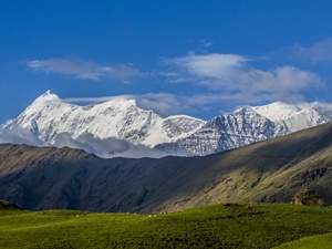
Ali Bedni Bugyal Trek

Pin Parvati Pass Trek
Submit this form that we can email you all the necessary details and call you to discuss., tour starting date: green boxed dates indicate starting of a scheduled fixed departure tour (day 1 of our tour itinerary). please check the calendar and choose a suitable fixed departure date (green boxed) unless dates are not matching or you are looking for a customised/private trip., i accept the terms & conditions.

Rupin Pass Trek
A thrilling mountain pass with countless waterfalls on the way, rupin pass trek overview.
On the way to Lower Waterfall Campsite
Day 1 Dehradun to Dhaula (1,580 m) drive: 200 KM in 8 hours
The drive from Dehradun to Dhaula passes through the towns of Mussoorie and the villages of Nainbagh, Damta, Naugaon, Purola and Mori. After Mori, it is a beautiful drive along the Rupin River through mixed oak and connifer forests. We reach Dhaula by evening. Overnight in camps.
Day 2 Dhaula (1,580 m) to Sewa (2,000 m) to Aaligad: 14 KM trek in 7 hours
This is the first day of our trek. The trail is on the true right of the valley climbing up gradually. Pisa and Khana villages are seen across the river. We climb up high above the river to Danti Dhar. The path passes through beautiful rhododendron forests. Sewa has a beautiful Hindu temple and lies on the border of the two states. We camp a little after the village on the banks of the river at a site known as Aaligad.
Day 3 Aaligad to Jakha (2,300 m): 9 KM trek in 4 to 5 hours
The trail continues along the true right of the valley. The trail is fairly gradual, going past the two large but remote villages of Dodra and Kuar. This region has recently been connected by road from Rohru (Shimla Region). The road is being extended till Jakha. We cross the bridge below Kuar village and take the path climbing up to the village. This path will join the trail on the true right below Jiskun village. From here the trail steeply climbs to Jiskun, which is located high above the confluence of Rupin and Narkund Khad. Jiskun has a small forest rest house. Continuing along the path, we descend steeply to a side tributary and after a short and steep ascent reach Jakha.
Day 4 Jakha to Burans Kandi (3,080 m): 7 KM trek in 5 to 6 hours
It is a beautiful walk through blue pine and maple forests. After a while the trail starts to descend to the river. There is a small bridge taking the trail to the true left of the valley. We camp overnight beside the river beside a spot frequented by shepherds.
Day 5 Burans Kandi to Lower Waterfall (3,450 m): 6 KM trek in 3 to 4 hours
The forest changes to silver Birch and rhododendron leading to alpine meadows. In season, the area looks spectacular with wild flowers and blue poppies. We walk on the large meadow surrounded by mountains and waterfalls. There is a huge and impressive waterfall in the middle of the valley leading up to the pass.
Day 6 Lower Waterfall to Rupin Pass Basecamp (4,350 m): 6 KM trek in 4 to 5 hours
We start early today to make it to the Base camp of the Rupin pass by afternoon. We start our journey towards the Waterfall and after traversing the steep sections we reach the Upper Waterfall campsite, which is majestic. We spend some time here enjoying the views and have our packed lunch. It seems an ideal campsite but we approach the base camp as it will reduce our ascent to the pass and offer a very different camping experience. The base camp is covered in snow till late June and thus camping in snow from the winters, is a vivid summer experience, with the entire campsite largely to ourselves as we leave most of the groups behind. In the evening we can go climb up the nearby ridges to get panoramic views of the landscape covered in snow.
Day 7 Basecamp (4,350 m) to Rupin Pass (4,690 m) to Ronti Gad (3,990 m): 9 KM trek in 7 to 8 hours
There are excellent views of the hanging glaciers and snow fields on the way to the pass. It is a fairly narrow and steep path through the boulders; in case of snow a rope maybe used. From the pass, one can witness great views of the Kinnaur Kailash range. We descend to the alpine meadows with lots of camping options.
Day 8 Ronti Gad to Kanda to Sangla (2,650 m): 12 KM trek in 5 to 6 hours
Today is a beautiful short trek through blue pine, deodar and oak forest overlooking the Sangla valley. It is a fairly steep descent. Sangla valley is known for growing one of the best quality apples in the world. It is also one of the starting points of the famous Kinnaur Kailash trek. Sangla is connected by road to Shimla. One can get public or private transport from Sangla to Shimla.
Day 2 How difficult is the trek & what are the challenges?
FAQ's about Rupin Pass Trek
What is the best time for rupin pass trek.
The optimal periods for the Rupin Pass Trek are summer (May & June) and post-monsoon (September & October). Summer offers pleasant conditions.
What is the fitness level required for Rupin Pass trek?
The Rupin Pass is a moderate-level trek. This trek needs a moderate level of fitness. You should feel at ease walking for a few hours on bumpy ground and have the energy to walk about 5 to 6 kilometers each day. You need strong lungs and legs. If you struggle a lot, you might not enjoy the beauty of the trek. So, make sure you’re ready for a good adventure.
How safe is it the Rupin Pass Trek?
Although the trek isn’t very hard, getting ready is really important for staying safe. Make sure you’re fit and have the right gear. This way, you can have a fun and safe trek!
How difficult is the Rupin Pass trek?
The Rupin Pass trek is known for being moderately challenging, making it suitable for both beginners and those with some hiking experience. It offers good accessibility, ensuring an enjoyable adventure for all.
What is the maximum and minimum age limit for The Rupin Pass trek?
This trek is open to people of different ages, from active 15-year-olds to lively folks in their 60s. But it depends on how fit you feel. It’s suggested that you should be able to walk 4 to 5 kilometers in 2 hours on a flat path without much trouble.
Where is the Rupin Pass trek located?
Rupin Pass is a tall path in the Himalayan mountains, located in Himachal Pradesh, India. It’s on a route that shepherds and hikers have used for a long time, starting in Dhaula, Uttarakhand, and finishing in Sangla, Himachal Pradesh.
What are some highlights of the Rupin Pass trek?
- Rupin Waterfall:- The Rupin Waterfall is a stunning natural wonder, plunging down 1500 feet. It’s one of the most famous spots on the trek. You can enjoy its beauty from the Lower Waterfall campsite or even try a thrilling climb nearby.
- The Rupin Valley is like a colorful painting with lively wildflowers and lush meadows. It’s a beautiful setting for the trek. The winding Rupin River adds to its charm, mirroring the tall peaks around it.
- Rupin Pass: Standing tall at 15,252 feet, reaching Rupin Pass is the pinnacle of the trek. It’s a moment of triumph, gifting trekkers with awe-inspiring, wide-ranging views of the mighty Himalayas.
- Nature’s Riches: The Rupin Pass trek boasts a diverse array of plant and animal life. Hikers may come across vibrant wildflowers, grand pine forests, and a spectrum of bird species, from the majestic Himalayan griffons to the graceful golden eagles.
- Rich Cultural Encounters: The trek winds through villages where vibrant local communities reside, offering a window into their distinctive culture and age-old traditions. Connecting with these friendly folks adds a unique and heartwarming touch to the journey.
- Personal Triumph: Conquering the Rupin Pass trek showcases not only physical strength but mental fortitude. Overcoming obstacles along the path amplifies the sense of achievement, making the journey all the more gratifying.
- Indelible Impressions: The Rupin Pass trek is an adventure that imprints itself onto memory. The breathtaking scenery, demanding trails and warm connections weave a tapestry of enduring moments.
What are some challenges of The Rupin Pass trek?
Even though the Rupin Pass trek is generally considered a moderate-level trek, it might be difficult or challenging if the below points are not taken care of-
- Physical stamina: This is crucial for any trek that you have good or normal stamina. Without it, the trek can be tough. Regular exercise and proper rest are essential to ensure you’re up for the challenge.
- Weather Variability: The Himalayan weather can be unpredictable. Without proper gear, sudden shifts in temperature, rain, or snowfall can pose challenges. Pack versatile clothing to stay comfortable in any condition.
- Basic Amenities: While campsites offer basic amenities, they may be limited. To ensure comfort, pack necessities like toiletries, a first-aid kit, and any personal medications for a hassle-free trekking experience.
What is the temperature during the Rupin Pass rek?
The Rupin Pass trek is best enjoyed in two main seasons: summer (May-June) and autumn (September-October). Weather conditions are most favorable during these times, but it’s crucial to pack suitable clothing due to varying temperatures between seasons and altitudes.
Summer (May-June):
- Daytime: Expect warm and sunny days with temperatures ranging from 17°C to 19°C.
- Nighttime: At higher altitudes, nights get colder, with temperatures dropping to around 0°C.
Autumn (September-October):
- Daytime: Days are still pleasant for trekking with temperatures between 12°C and 16°C.
- Nighttime: As autumn progresses, expect even lower temperatures. At higher campsites, it can drop to around -4°C with possible frost.”
What is the best time to do the trek and how is the weather?
What are the top highlights of the trek.
There are no reviews yet.
Your email address will not be published. Required fields are marked *
Your review *
Name *
Email *
Save my name, email, and website in this browser for the next time I comment.
- Transport Support from Dehradun to Dhaula on Day 1
- All Meals from Day 1 Dinner to Last Day Breakfast
- Adventure Trek Insurance
- Camping & Dining Equipment
- Certified Guide, Cook & Support Staff Fee
- Forest Permits
- Your designated hotels may not reopen by the time you reach there. While we are making alternate arrangements, do understand that things may not be as “tip-top” as our designated hotels.
- The gurudwara, Hemkund Sahib may not be open. While we are trying to take permission to go to Hemkund Sahib, if it does not happen, then do understand that the pandemic has put restrictions beyond our control.
- Personal expenses like tips, personal medicines, phone calls etc.
- Any transport support during the trek apart from what is included above
- Any cost or services not mentioned in the Inclusions
- Accommodation apart from the trek
- Adventure Insurance
- Cost arising due to unforeseen incidents like bad weather, medical evacuation, roadblocks etc
- Porter and mule support to carry personal Luggage can be arranged at an additional cost of INR 500 per bag per day (weighing up to 12 kg)
- Lunch box for packed lunch/breakfast. To avoid using polythenes and Aluminium foils. Keeping the Himalayas clean is our own responsibility. Reduce the use of Plastic when you are in the abode of the Sacred Himalaya.
Upcoming Treks
- 17-07-2021 to 23-07-2021 open
- 17-07-2021 to 23-07-2021 close
Send Request
Your query has been successfully registered. we will contact you within 24 hours., something went wrong.try after sometime..
- +91-8218331684
- [email protected]
- Your cart is empty
- Himachal Pradesh
Rupin Pass Trek
from 0 review
Specific Tour
Description
Rupin Pass offers you diversity in every form, this high-altitude trek is a favourite amongst adventure-seeking souls. The high altitude is not just the sole reason for its popularity among trekkers, the diversified number of sceneries and sudden variation in trails also attract many nature lovers. Even trekking for 5 to 6 hours on average while advancing 10 km each day can prove strenuous for some, but the thrill of adventure and the experience it offers along with the magnificent views are worth the effort. En route you will encounter many waterfalls and streams flowing down, scenic routes throughout the trail will keep you engaged in the beauty of nature.
Rupin Pass Trek Distance /Altitude
The Rupin Pass Trek is a thrilling adventure that takes you through the mesmerizing beauty of Himachal Pradesh. This trek begins from the quaint village of Bawta, and covers a total distance of 52 km before concluding at Sangla. The trek typically lasts for 7 days, and includes travel from Shimla to Bawta.
The lowest altitude will be 7,700 ft at Bawta and the highest at 15,350 ft at Rupin Pass Summit. The trail takes you through some of the most stunning and diverse landscapes of the region, including lush green forests, quaint villages, gushing streams, and snow-capped peaks.
Rupin Pass Trek Difficulty Level
The Rupin Pass Trek is a moderate to difficult level trek that requires a certain level of physical and mental preparedness. The trail covers a total distance of 52 km, and takes you through varied landscapes and terrains, including steep inclines, rocky paths, and narrow ridges.
Before embarking on this adventure, it is important to ensure that you are physically fit and have a regular fitness routine in place. This will help you build the endurance and stamina required to tackle the challenging terrain of the trail.
Therefore, it is advisable to prepare yourself well in advance by following a fitness regime and mentally preparing yourself for the challenges that await you. Read more – Fitness preparation for Himalayan trek.
Best Time to Visit Rupin Pass
Rupin Pass is done during the months of May to June and September to October. However summer months of May to June are considered the best time to visit Rupin Pass. The weather during this time is pleasant, and the temperature ranges between 10 to 15 degrees Celsius during the day and drops to 0 to 5 degrees Celsius at night. The snow starts melting during this time, and the trail opens up for trekking. The trekking route is adorned with beautiful flowers and lush greenery, making it a perfect time to visit for nature lovers. The clear skies and sunshine also offer stunning views of the surrounding mountains.
The monsoon season in Rupin Pass starts from July to August and is not recommended for trekking. The risk of landslides and flooding also increases during this time, making it dangerous for trekkers.
The post-monsoon season from September to October is another good time to visit Rupin Pass. The weather during this time is pleasant, and the temperature ranges between 5 to 10 degrees Celsius during the day and drops to -5 to 0 degrees Celsius at night. The trail is less crowded during this time, making it an ideal time for trekkers who prefer solitude. The autumn season also offers a stunning view of the surrounding mountains, which are covered in hues of red, yellow, and orange.
Rupin Pass Trek Weather/Temperature
May to June is considered the best time to trek the Rupin Pass. During this time, the weather is pleasant, and the temperature ranges between 15°C to 20°C during the day and 5°C to 10°C at night. The skies are clear, and the visibility is excellent, making it an ideal time for photography and sightseeing.
September to October is another good time to trek the Rupin Pass. During this time, the monsoon season is over, and the weather is dry and cool. The temperature ranges between 10°C to 15°C during the day and 0°C to 5°C at night. The skies are clear, and the views of the snow-capped mountains are breathtaking.
Accommodation and Meals
At Bawta and Jakha trekkers will have to share the room on a triple and quad basis. During the trek, you will be provided 3-person tents on a twin-sharing basis and 4-person tents on a triple-sharing basis. Female trekkers will share a room/tent with female trekkers only. Solo female trekkers will be provided with a separate tent
Meals start from day 1 dinner to day 6 dinner. On Day 7, early departure after tea. During the trek, you will be provided healthy hot meals which include breakfast, lunch, evening tea and snacks, hot soup, and dinner with daily different desserts. Hot drinking water will be provided daily at the campsite.
How to Reach Bawta | Delhi to Bawta Distance and Trek Route
You can reach Shimla by boarding an overnight train from New Delhi Railway station. Transport from Shimla would be arranged by us for additional charges. Trekkers can choose to reach their own also to Bawta if they are aware of the route and public travel options.
Departure: Points: We have fixed departures from Shimla. The pickup will be at 6:30 am from Shimla Old Bus Station
Fixed Departures Dates
May 2022 – 15 and 21
How to Reach Shimla
Jubbarhatti airport is 22km away from Shimla this airport is well connected to various cities. Another major nearby airport is Chandigarh airport from there you can hire a cab to reach Shimla.
You can take the train from New Delhi to Kalka it will take approximately 4 hours. After reaching Kalka you can hire a cab to Shimla it will take about 1 hour to reach there.
There are several bus services that run from Delhi to Shimla every day; you can take a luxury air-conditioned bus from ISBT to Shimla. The journey is of about 11 hours.
Note: Always book your return flight/train tickets after including the buffer day in your itinerary. Buffer days are kept for unforeseen conditions in the mountains, if not used; you can use them for sightseeing in Shimla.
What to Carry on the trek?
The key to staying comfortable while on an active trip is layering. To get maximum comfort with minimum weight, you need versatile layers that mix and match to create the right amount of insulation, ventilation, and weather protection. This gear list has been created to help you choose the proper equipment. Try to bring only what is necessary; this will help you and the field staff.
- Thermals – Tops and Bottoms
- Day Pack (20 L-30 L) and Rucksack 50 L – 60 L
- Bag Rain Cover
- Fleece pants
- Woollen gloves and Woollen cap
- Fleece/ Woollen Jacket or Sweater
- Headlamp with Fresh Batteries
- Hiking Pants (Warm, Convertible, Quick-Dry, Lightweight)
- Woollen Socks (4-5 pairs)
- Trekking poles (1 Pair)
- Insulated Jacket
- Long Sleeve Shirts (Synthetic, Lightweight)
- Rain-Coat/ Poncho
- Sport Sunglasses and Sun cap
- Hiking shoes
- Sun Block and Lip Balm
- Water Bottles
- The picturesque landscapes of the region, including alpine meadows, dense forests, and snow-capped peaks, make for stunning scenery throughout the trek.
- The trail takes trekkers through remote villages, providing an opportunity to witness the traditional culture and lifestyle of the local people.
- The crossing of the Rupin Pass itself is a highlight, as trekkers navigate a challenging ascent to an altitude of 4,650 meters (15,256 feet) above sea level.
- The trek offers breathtaking views of the Kinnaur Kailash range, the Baspa valley, and the Sangla valley, providing some of the most stunning vistas in the Indian Himalayas.
- The opportunity to witness the Rupin River in all its glory, including its dramatic waterfalls and rapids, is another highlight of the trek.
- The chance to meet and trek with like-minded people from all over the world, forging new friendships and shared experiences, is an added bonus of the Rupin Pass trek.
Day 1 SHIMLA TO BAWTA (7, 700 ft feet, 150 Km / 9 -10 Hours)

On Day 1 of the Rupin Pass trek, you will be driven from Shimla to Bawta, the base camp for the trek. Bawta is located at an altitude of 7,700 feet and is approximately 150 km away from Shimla. The journey takes around 9-10 hours and is a scenic drive through well-maintained roads with picturesque views of the hills. Pick-up for the drive will be at 6:30 am from Shimla Old Bus Station, and dinner will be provided upon arrival at the homestay in Bawta. All mobile networks are available at the base camp. If you are traveling from Delhi, you can board an overnight train to Shimla, and transportation from Shimla to Bawta can be arranged for an additional charge. Alternatively, if you are familiar with the route and public transportation options, you can make your own way to Bawta.
Day 2 BAWTA TO JHAKA (7, 700 ft. to 9000 ft)

The second day of the trek involves a moderate ascent to Jiskun, followed by a slight descent, with various topographic features to navigate along the 5 km trail. The day ends at Jhaka, where you will be staying in a homestay. The trail offers scenic views of the Selwan Khad, and you can refill your water bottles en route. The trek is moderate in difficulty, allowing you to enjoy the pleasant weather and indulge in snacks with tea as you approach Jiskun. The trek takes approximately 4 hours to complete and reaches an altitude of around 9,000 ft. There is no network connectivity along the trail, allowing you to disconnect and immerse yourself in the serene surroundings. The homestay provides breakfast, lunch, and dinner to keep you energized for the journey ahead.
Day 3 JHAKA TO DHANDERAS THATCH (9000 ft to 11, 700 ft)
On the third day of your Rupin Pass trek, you will embark on an exciting 11-kilometer journey that will take approximately 8 to 9 hours to complete. Starting early in the morning, you will leave your campsite at Jhaka and head towards Dhanderas Thatch. As today's trek trail is a bit challenging, you will receive instructions on how to make your trek day enjoyable, with minimal difficulty. The trail is adventurous and exciting in every way, with a tricky terrain that can be slippery and prone to landslides, requiring you to be cautious while trekking. Leaving Jhaka behind, you will cross mixed crop fields and enter a dense, dark jungle, which brings a sense of adventure as you encounter a change in vegetation. As you proceed through the jungle and hop over the little rivulets and streams along the way, you will eventually reach a wooden bridge. After a bit of hiking from here, you will begin your steep ascent to Saruwas Thatch, passing through vibrant mountain vegetation that includes Deodar and Walnut trees. Once you complete your trek for the day, you will gradually descend to Dhandarus Thatch, where you will reach your destination and rest in the tents.
Day 4 DHANDARAS THATCH TO UPPER WATERFALL
On the fourth day of the Rupin Pass trek, you will be covering a distance of approximately 5 kilometers, which should take around 4 hours to complete. During this time, you will ascend to an altitude of 13,300 feet, where you will be staying in tents for the night. The initial part of the trek involves a zig-zag trail through mixed dense forests, with a cliff on the other side. As you continue climbing, you will witness abrupt changes in the terrain and surroundings, making the climb to the Upper waterfall quite interesting and entertaining. The ascent to the waterfall is challenging, and proper acclimatization and briefing are essential. However, the stunning scenery and breathtaking views of the surrounding landscapes make the effort worthwhile. After reaching the waterfall, you will be left wondering how such a beautiful trail was cut out from a rock face.
Day 5 UPPER WATERFALL TO RONTI GAD VIA RUPIN PASS
The altitude of this section of the Rupin Pass trail is 15,350 ft, making it the highest point of the trek. Accommodation will be in tents. The trek covers a distance of 11 km and takes about 10 hours to complete. This segment of the trek is also the most challenging, involving an elevation gain from 13,100 ft to 15,400 ft, followed by a steep descent back to 13,100 ft. Water sources are limited, so it is important to refill water bottles at the Rati Pheri campsite. The trek begins with a steep climb from the Upper waterfall to the Rati Pheri Campsite. This site is covered in stretches of snow, and from here, trekkers must navigate through the snowy tracts to reach the Rupin Pass gully. Crossing the snowfields and catching a glimpse of Rupin Pass in the distance can be both challenging and exhilarating. As there are no well-defined tracks, precautions must be taken to avoid slips and slides. A sense of direction is also crucial. Once at the Rupin Pass, the trek becomes a gentle walk followed by a descent to Ronti Gad.
Day 6 ACCLIMATIZATION/BUFFER DAY
A buffer day is included in the itinerary to accommodate unfavorable weather conditions such as heavy rain or other climatic barriers. This day can be utilized earlier or later in the trek depending on the need. Acclimatization is crucial for the Rupin Pass trek, and this day cannot be ignored. If trekkers feel tired, this rest day can be used to rejuvenate. To complete this challenging trek, proper preparation and listening to your body are essential. Any physical symptoms such as headaches, nausea, dizziness, or chest pain should be communicated immediately to the trek leader. With adequate fitness, hydration, and acclimatization, the Rupin Pass trek can be completed with ease.
Day 7 RONTI GAD TO SANGLA AND DRIVE BACK TO SHIMLA
The trek on this day covers a distance of 12 km with a moderate ascent of 4 hours followed by a difficult steep ascent. Breakfast will be provided as the meal for the day. Later in the day, we will drive from Sangla to Shimla and are expected to arrive by 12:00 am. We recommend booking accommodation in Shimla accordingly to ensure a comfortable stay. On the final day of the itinerary, the trek involves an 8 km descent from Ronti Gad to Sangla. Please exercise caution while descending from high altitude as it can be harmful to your knees. Follow the instructions given by the trek leader throughout the trek. For those who have booked their travel with us, you can board the cab for the 9-10 hour long drive from Sangla to Shimla. We will reach Shimla late at night, so please pre-book your stay or travel accordingly.
Included/Excluded
- Food as per menu on the trek.
- Tents, Sleeping bags, mats.
- Forest permits and camping fee.
- Trek guide, cook, support staff
- Porters/mules to carry trekking equipment.
- First aid medical kit, oxygen cylinder, and UIAA certified safety equipment.
- Any kind of personal expenses on the trek.
- Transport is available from Shimla to Shimla at an additional cost.
- Meal during road journeys.
- Mules or porter to carry personal luggage.
- Any kind of travel insurance.
- Anything not specified in the inclusion list.
Tour's Location
Will there be water sources on the way will two liters of water be enough.
Our campsites are pitched near water sources. For your day’s trek, two liters of water should be enough. You will find water sources on the trek to refill your water bottles. Your trek leader will brief you about these before starting the day’s trek.
What is the washroom/toilet facilities like on the trek?
During the trek, toilet tents will be set up along each campsite. A toilet tent will have a deep pit, where one can answer nature’s call. There will be a mound of soil and a shovel to cover it up. These are dry toilets, where you’ll have to use toilet paper. This is the most hygienic and convenient way to answer nature’s call in the wild. Please use plain toilet paper and refrain from using wet wipes since these are not biodegradable.
What if it rains while trekking?
If it starts raining while you’re trekking, we will continue on the trail as planned. Your poncho should protect you from the rain. Carry a backpack cover for extra protection from rain for your belongings.
When it gets really cold can I consume alcohol?
Alcohol is dangerous in extreme cold, especially at high altitudes. Contrary to what people believe, alcohol does not make you warmer. Instead, it opens your pores, making your body colder. Moreover, it dehydrates you very quickly. Hence consumption of alcohol is absolutely prohibited on all Nomad Adventures treks. Anyone found with alcohol is quickly removed from the trek. Smoking, similarly, is not allowed on Nomad Adventures treks.
Are trek poles, jackets and other equipment available for rent from Nomad Adventures?
No, but there are shops on the base camp from where you can rent shoes, jackets and trek poles, headlights etc.
Do I need special snow shoes on this trek?
You don’t need special snowshoes. A good waterproof trekking shoe is sufficient for the trek. When there is snow, we provide micro spikes and gaiters.
Why is the trekking pole necessary?
A trekking pole gives you stability and balance and helps reduce fatigue.
What is the age limit?
The minimum age limit is 8 years. However, minors aged between 8 to 17 should be accompanied by their parents and guardians.
Can I take my child along on this trek?
Rupin Pass is a medium to difficult level trek and it requires trekkers to be physically fit. The minimum age eligibility is 8 years.
Is there a mobile network on this trek? And, what about charging points?
The last electricity charging point would be in Shimla. You’ll get only the Bsnl network till Bawta. However, come prepared for the possibility of power cuts at Bawta. It is good to carry your power banks.
I am solo female trekker. Do I need to share a tent with a male?
No, Female Trekkers share Room/Tent with female co-trekkers and the same applies to others.
Is it safe to trek with Nomad Adventures?
All high-altitude treks come with their share of risks. We pay utmost importance to the safety of trekkers. While we do our bit to ensure a trekker is safe, we also expect any trekker who is enrolling with us to know what could go wrong, and if it does, how to tackle it.
Can I leave my extra luggage behind and collect after the trek?
Since you will not be returning to the same point of the trek, therefore you have to carry all your belongings. At Shimla, you can ask your respective homestay/hotel owners to provide some space for extra luggage.
Is Diamox advisable?
No, but in case you are having so please consult your doctor because there are lots of myths about Diamox.
Write a review
Leave a review cancel reply.
Your email address will not be published. Required fields are marked *
- Transport Both Side(₹2000) 0 1 2 3 4 5 6 7 8 9 10 11 12 13 14 15 16 17 18 19 20 21 22 23 24 25 26 27 28 29 30
or continue with
Enter the e-mail address associated with the account. We'll e-mail a link to reset your password.

- Summer Treks
- Popular Treks
- Winter Treks
- Difficult Treks
- Latest Treks
- +91-8445363881
- +91-8439264816
- [email protected]

Rupin Pass Trek
- Share This Post:
Rupin Pass Trek the most popular trek in the Himalayas
Rupin Pass Trek is undoubtedly one of the most popular treks in the Himalayas, drawing adventurers and nature enthusiasts from around the globe. Situated in the picturesque state of Uttarakhand, India, this trek offers a thrilling journey through diverse landscapes, including dense forests, gushing rivers, alpine meadows, and snow-capped peaks.
Trekkers embark on a challenging yet rewarding expedition that takes them to an altitude of over 15,000 feet above sea level. The highlight of the trek is crossing the Rupin Pass, a high-altitude mountain pass that offers panoramic views of the surrounding Himalayan ranges.
Throughout the trek, trekkers are treated to breathtaking vistas of towering peaks, pristine valleys, and cascading waterfalls, making it a photographer's paradise. The trail also passes through remote villages and ancient temples, providing a glimpse into the rich cultural heritage of the region.
With its stunning natural beauty, challenging terrain, and unique cultural experiences, Rupin Pass Trek has rightfully earned its reputation as one of the most iconic treks in the Himalayas.
A story of Rupin Pass that makes this trek Memorable
In the heart of the Himalayas lies a trail less traveled, a journey that weaves through the rugged terrain and whispers tales of adventure and discovery. This is the story of the Rupin Pass Trek, a trek that etches itself into the memories of those who dare to embark on its path.
It all begins in the quaint village of Dhaula, where a group of trekkers gather, their spirits high with anticipation. As they set foot on the trail, they are greeted by the majestic beauty of the mountains, their peaks reaching for the sky like ancient sentinels.
The trail unfolds before them, revealing a tapestry of landscapes – lush forests teeming with life, meadows adorned with colorful wildflowers, and icy streams gushing down rocky slopes. Each step brings them closer to the heart of the Himalayas, and with each passing day, they find themselves immersed in a world of wonder and awe.
But it is the ascent to the Rupin Pass that truly defines this trek. As they climb higher and higher, the air grows thinner, the wind whispers secrets of the mountains, and the landscape transforms into a snow-covered wonderland. With each labored breath, they push themselves forward, driven by the promise of reaching the summit.
And then, finally, they stand at the top of the world – the Rupin Pass. The view takes their breath away – a panorama of snow-capped peaks stretching as far as the eye can see, a testament to the majesty of nature. In that moment, they are overcome with a sense of accomplishment, of having conquered the mighty Himalayas.
But the journey doesn't end here. As they descend from the pass, they carry with them memories that will last a lifetime – of laughter shared around campfires, of friendships forged on the trail, and of moments of quiet contemplation amidst the grandeur of nature.
And so, the story of the Rupin Pass Trek lives on, a tale of adventure and discovery, of pushing boundaries and embracing the unknown. For those who embark on this journey, it is a story that will forever be etched into their hearts and minds, a story that makes this trek truly memorable.
What is Dhaula base camp in Rupin Pass Trek?
Dhaula serves as the base camp for the Rupin Pass Trek, situated in the Uttarkashi district of Uttarakhand, India. It is the starting point of the trek and acts as a hub for trekkers to organize their supplies, meet their guides, and begin their journey into the Himalayas.
Dhaula is a small village surrounded by lush greenery and picturesque landscapes. Trekkers typically arrive in Dhaula by road from nearby towns like Dehradun or Uttarkashi. From Dhaula, the trekking trail leads adventurers through a variety of terrains, including dense forests, meadows, and rocky paths, as they make their way towards the Rupin Pass.
At Dhaula, trekkers can find basic amenities such as guesthouses, camping grounds, and shops selling essential supplies. It is also common for trekkers to acclimatize to the altitude at Dhaula before beginning the ascent towards higher altitudes.
Overall, Dhaula base camp serves as the starting point and logistical hub for trekkers embarking on the Rupin Pass Trek, providing a convenient and comfortable place to prepare for the adventure ahead.
Why do Rupin Pass Trek from Dhaula ?
Rupin Pass Trek from Dhaula offers trekkers several advantages that contribute to a memorable and fulfilling experience. Here are some reasons why Dhaula serves as the ideal starting point for the Rupin Pass Trek:
- Scenic Starting Point: Dhaula is nestled amidst stunning natural beauty, surrounded by lush greenery, snow-capped peaks, and pristine landscapes. Trekkers are immediately greeted by the majestic Himalayan scenery, setting the tone for an unforgettable journey.
- Accessibility : Dhaula is easily accessible by road from nearby towns like Dehradun and Uttarkashi. This makes it convenient for trekkers to reach the starting point of the trek without hassle, allowing them to focus on preparing for their adventure.
- Basic Amenities: Dhaula offers basic amenities such as guesthouses, camping grounds, and shops selling essential supplies. Trekkers can comfortably acclimate to the altitude, rest, and stock up on necessities before beginning their trek.
- Well-Defined Trail: The trekking trail from Dhaula to Rupin Pass is well-defined and relatively accessible, making it suitable for trekkers of varying skill levels. The trail takes trekkers through diverse landscapes, including forests, meadows, and rocky terrain, offering a rewarding and varied experience.
- Cultural Experience: Starting the trek from Dhaula allows trekkers to immerse themselves in the local culture and way of life. Trekkers may encounter villagers along the way, providing opportunities for cultural exchange and interaction with the local community.
Overall, choosing to start the Rupin Pass Trek from Dhaula ensures a seamless and enjoyable trekking experience, with easy access, stunning scenery, and opportunities for cultural immersion.
Witness the Dynamic sceneries of Rupin Pass
Experience the breathtaking beauty of the Rupin Pass as it unveils a dynamic array of sceneries that captivate the senses and ignite the spirit of adventure. From lush green valleys to snow-capped peaks, cascading waterfalls to rugged landscapes, the Rupin Pass trek offers a mesmerizing journey through nature's grandeur.
As trekkers traverse the trail, they are treated to ever-changing vistas that unfold before their eyes. The trek begins amidst verdant forests teeming with life, where the air is filled with the fragrance of pine and the melodious chirping of birds.
Ascending higher, trekkers are greeted by alpine meadows adorned with colorful wildflowers, painting the landscape with hues of red, yellow, and purple. The gentle slopes give way to steep ridges and rocky terrain, challenging trekkers to push their limits and conquer new heights.
At the heart of the trek lies the majestic Rupin Pass itself, a snow-clad wonderland that offers panoramic views of the surrounding Himalayan peaks. Here, trekkers stand in awe of nature's raw beauty, surrounded by towering mountains and vast expanses of untouched wilderness.
As the trek descends, trekkers are rewarded with glimpses of quaint villages nestled amidst terraced fields, where locals offer warm hospitality and a glimpse into traditional mountain life.
Throughout the journey, the dynamic sceneries of the Rupin Pass never cease to amaze, leaving trekkers with memories that last a lifetime. Whether it's the sight of a majestic waterfall, the tranquility of a mountain lake, or the thrill of conquering a challenging pass, the Rupin Pass trek promises an adventure like no other.
Why to choose Rupin Pass Trek
Choosing the Rupin Pass Trek offers adventurers a truly unforgettable experience amidst the majestic Himalayas. Here are compelling reasons why this trek is a must for outdoor enthusiasts:
- Spectacular Scenery: The Rupin Pass Trek traverses through diverse landscapes, including lush forests, alpine meadows, gushing rivers, and snow-capped peaks. Each day brings new and breathtaking vistas, providing a visual feast for trekkers.
- Adventure Challenge: The trek presents a thrilling challenge with its varying terrain and altitudes, making it ideal for trekkers seeking an adrenaline rush. Crossing the Rupin Pass itself, standing at over 15,000 feet, offers a sense of achievement and adventure.
- Cultural Immersion: Along the trail, trekkers encounter remote villages inhabited by warm and hospitable locals. This presents opportunities to immerse oneself in the local culture, interact with villagers, and learn about their traditional way of life.
- Wildlife Encounters: The trekking route is home to diverse flora and fauna, including rare Himalayan species such as the Himalayan Monal, Musk Deer, and Blue Sheep.
- Spiritual Solace: The serene and pristine surroundings of the Himalayas offer a perfect environment for spiritual rejuvenation and introspection. Trekkers can find solace amidst the tranquility of nature and connect with their inner selves.
- Photography Paradise: The stunning landscapes, dramatic vistas, and vibrant flora make the Rupin Pass Trek a paradise for photographers. Every corner presents a picture-perfect moment waiting to be captured.
- Unique Experience : The Rupin Pass Trek offers a unique blend of adventure, natural beauty, cultural immersion, and spiritual solace, making it a once-in-a-lifetime experience for trekkers of all levels.
Rupin Pass safe for me ?
Absolutely, Rupin Pass Trek is considered safe for trekkers who are adequately prepared and take necessary precautions. However, it's important to keep in mind the following safety measures:
- Physical Fitness: The trek involves moderate to strenuous hiking, so it's essential to be in good physical condition. Regular exercise and cardiovascular activities can help prepare your body for the trek.
- Acclimatization: Acclimatize properly to the altitude to avoid altitude sickness. Ascend gradually, stay hydrated, and listen to your body's signals. Take breaks as needed and descend if you experience severe symptoms of altitude sickness.
- Weather Conditions: Check weather forecasts before starting the trek and be prepared for sudden changes in weather. Carry appropriate clothing and gear for protection against rain, wind, and cold temperatures.
- Guide and Route Knowledge : Hire an experienced guide who is familiar with the terrain and route. Follow their instructions and stay on the designated trail to avoid getting lost.
- Emergency Preparedness: Carry a first aid kit with essential medications, bandages, and other medical supplies. Additionally, have a communication device such as a satellite phone or a reliable mobile network for emergencies.
- Group Trekking: It's safer to trek in a group rather than alone. Stay with your group and look out for each other during the trek.
- Respect Wildlife: Respect the wildlife and avoid approaching or disturbing animals in their natural habitat.
By following these safety measures and being prepared, you can enjoy a safe and memorable trekking experience at Rupin Pass.
What things should you keep in mind for the Rupin Pass trek?
Rupin Pass trek, it's crucial to keep several key considerations in mind to ensure a safe and enjoyable experience:
- Physical Fitness: The Rupin Pass trek involves moderate to strenuous hiking over varied terrain and altitudes. Prioritize physical fitness and endurance training to prepare your body for the demands of the trek.
- Altitude Acclimatization: Acclimatize gradually to the increasing altitude to avoid altitude sickness. Ascend slowly, stay hydrated, and listen to your body's signals. Take breaks as needed and descend if you experience severe symptoms.
- Weather Conditions: Be prepared for changing weather conditions, including rain, wind, and cold temperatures, especially at higher altitudes. Pack appropriate clothing and gear, including waterproof layers, insulated clothing, and sturdy hiking boots.
- Packing Essentials: Pack essentials such as a first aid kit, sufficient water, high-energy snacks, sun protection (hat, sunglasses, sunscreen), navigation tools (map, compass, GPS device), and a communication device (satellite phone, mobile phone with a reliable network).
- Trekking Gear: Invest in quality trekking gear, including a sturdy backpack, trekking poles, sleeping bag, and tent (if camping). Ensure your gear is lightweight, durable, and suitable for the terrain and weather conditions.
- Route Knowledge: Familiarize yourself with the trekking route, including trail maps, elevation profiles, and potential landmarks. Hire an experienced guide if necessary and follow established trails to avoid getting lost.
- Environmental Conservation: Practice Leave No Trace principles to minimize your impact on the environment. Pack out all trash, avoid disturbing wildlife, and respect the natural surroundings.
- Safety in Numbers: Trekking in a group is safer than trekking alone. Stay together with your trekking companions, communicate openly, and look out for each other throughout the trek.
By keeping these considerations in mind and adequately preparing for the Rupin Pass trek, you can ensure a safe, rewarding, and memorable adventure in the Himalayas.
Summer Season
During the summer season, which typically spans from April to June, the Rupin Pass trek experiences mild to warm temperatures in the lower altitudes, making it an ideal time for trekking. The weather is generally clear, offering excellent visibility of the surrounding landscapes. However, trekkers should be prepared for occasional rain showers and fluctuating weather conditions, especially at higher elevations.
Monsoon Season
The monsoon season, from July to September, brings heavy rainfall and increased humidity to the region. Trekking during this time can be challenging due to slippery trails, muddy terrain, and the risk of landslides. It is generally not recommended to undertake the Rupin Pass trek during the monsoon season due to safety concerns and limited visibility of the scenic views.
Winter Season
From October to March, the winter season brings cold temperatures and snowfall to the Rupin Pass trekking route. While trekking during winter offers a unique experience of snow-covered landscapes and pristine scenery, it requires careful planning and preparation. Trekkers should be equipped with appropriate cold-weather gear, including insulated clothing, waterproof boots, and snow equipment. Additionally, the trail may be more challenging to navigate due to snow accumulation, so trekkers should exercise caution and consider hiring experienced guides.
Altitude we are going to cover in Rupin Pass Trek
Rupin Pass Trek encompasses a wide range of altitudes as trekkers traverse through diverse landscapes. The trek starts at an elevation of approximately 6,000 feet (1,828 meters) in the village of Dhaula, the base camp for the trek. From there, trekkers gradually ascend to higher altitudes, reaching the Rupin Pass summit at an impressive altitude of over 15,000 feet (4,572 meters) above sea level. This significant elevation gain offers trekkers stunning panoramic views of the surrounding Himalayan peaks. Throughout the trek, trekkers experience varying altitudes as they navigate through valleys, meadows, forests, and rugged mountain terrain, making the Rupin Pass Trek an exhilarating adventure filled with altitude changes and breathtaking landscapes.
Key Points This Trek
Duration: The Rupin Pass Trek typically takes around 8 to 10 days to complete, depending on the itinerary and trekking pace.
Base camp: The trek starts from the village of Dhaula, located in the Uttarkashi district of Uttarakhand, India. Dhaula serves as the base camp for the Rupin Pass Trek.
Summer Temperature: During the summer season, temperatures in the lower altitudes of the trekking route range from mild to warm, with daytime temperatures averaging between 15°C to 25°C (59°F to 77°F). However, temperatures can drop significantly at higher altitudes, especially during the early mornings and evenings.
Altitude: The highest point of the Rupin Pass Trek is the Rupin Pass itself, which stands at an altitude of over 15,000 feet (4,572 meters) above sea level.
Best Time: The best time to undertake the Rupin Pass Trek is during the pre-monsoon season from May to June and the post-monsoon season from September to October. These months offer favorable weather conditions with clear skies and pleasant temperatures, making for an enjoyable trekking experience.
Trek Level: The Rupin Pass Trek is considered moderately challenging, suitable for trekkers with prior trekking experience and good physical fitness. The trek involves ascending and descending steep mountain trails, crossing rivers, and navigating through varied terrain.
Trek Distance: The total trek distance for the Rupin Pass Trek is approximately 50 to 60 kilometers, depending on the specific route chosen and any side excursions taken along the way.
Group Size: The ideal group size for the Rupin Pass Trek can vary but typically ranges from 6 to 12 trekkers per group. Trekking in a group allows for mutual support, camaraderie, and safety during the trek.
Short Itinerary Rupin pass
Day 1 :Pickup to you from Dehradun railway station drive to Dhaula camp (210 km) (8/9 Hours) (5,067) feet)
Day 2 :Trek from Dhaula camp to Sewa village (7.8 km) (5/6 Hours) (6,295 feet)
Day 3 :Trek from Sewa village to Jiskun / Jhaka village (09.2 km) (5/6 Hours) (7,700 feet)
Day 4 :Trek from Jhaka village to Udaknal camp (9.8 km) (6/7 Hours) (10,090 feet)
Day 5 :Trek from Udaknal camp to Dhandaras thatch camp (8.2km) (4/5 Hours) (11,710 feet) hours)
Day 6 :Trek from Dhandaras thatch camp (4 km) (2/3 Hours) ((13,112 feet)
Day 7 : Trek from camp to Rupin Pass summit (15,260 feet) via Rati Pheri and Ronti Gad (13,112 feet) (13 Km) (10-11hours)
Day 8 : Trek Ronti Gad camp to Sangla road head (11 km) (5/6 Hours) (8,600 feet) via Sangla Kanda
Included/Exclude
- Forest Permit and entrance fee
- Accommodation in Hotel on twin share basis
- All meals: breakfast, packed lunch, tea, coffee, snacks, soup and Dinner
- Good Experience Local Trek Leader guide and Technical guide
- Medical Kit
- Oxygen Cylinders
- Personal Insurance
- Medical Certificate
- Personal toiletry Items
- Personal Medicine kit
Tour Amenities
Related tours.

Bali Pass Trek

- Amenities 5
Kedarkantha Trek

Kuari Pass Trek
Review scores, add a comment cancel reply.
Save my name, email, and website in this browser for the next time I comment.
Tour Information
Tour location, languages support.

Char Dham Yatra

Mount Srikantha Expedition

Khatling Glacier Trek

Black Peak Expedition

Satopanth Expedition

Roopkund Trek

Expeditions

Reset Password
WhatsApp The Hidden Himalaya
Best summer destinations : Chopta - Nainital - Mussoorie - Kanatal - Dhanaulti - Chakrata - Auli - Kausani - Mukteshwar - Chaukori - Pangot

- Rupin Pass Trek
- Uttarakhand
- Uttarakhand Tourism
- 1 Tour Packages
- Send Enquiry
Rupin Pass - Iceland of India
The Rupin Pass Trek is one amongst the most ecstatic and a delightful trek to go on to for every trekker. It is a high altitude trek at an elevation of 4650 mts that starts from Dhaula in Uttarakhand and ends in Sangla in Himachal Pradesh.

Get Rupin Pass trek route, trekking guide & trekking tips
- Rupin Pass Trek Tour Packages

- Tour Packages
The Rupin Pass Trek is not just a high altitude two states trek but it is no less than a heavenly kingdom for all the nature lovers. The trek holds gorgeous sceneries along with sudden variations in the trail which gives it a kaleidoscopic beauty. The scenery is complemented by the blue waters of the Rupin rushing along with it, culminating the very famous three-stage waterfall of Rupin.
For those who want to have a complete experience of every kind of sightseeing in the Himalayas, be it, the hanging villages, the dense forest, the snow glazed peaks, hundreds of waterfalls or the glacial meadows; The Rupin Pass Trek is a treat to drool for. The trek may be drool-worthy but it is a moderate-difficult trek and requires a good level of physical fitness and a good lung and cardio power, so make sure you prepare yourself nicely before heading out for trekking to the Rupin Pass Trek.
Best Time for Trekking for Rupin Pass
The Best time to visit the Rupin Pass Trek is during the months of May, June and September. Although a slight change in atmospheric pressure or a shift in wind can bring rainfall or snowfall during the Rupin Pass Trek
Activities in Rupin Pass Trek
Things you can experience during rupin pass trek.
The Rupin Pass Trek holds on to an extremely gorgeous adventure that is both badass and beautiful. While trekking to the Rupin Pass you may find the following memorable sceneries and things.
Waterfalls - at Rupin you will encounter hundreds of waterfalls cascading down with a rush from high mountains, these waterfalls fall from such a height that it may seem as if they are falling from the sky.
Jhaka Villgae, the hanging Village- a very well established and uniquely positioned village which is located at the edge of a mountain range, making it appear to hanging out through a cliff.
Snow Bridges- There are numerous snow bridges on the trek, looking at these bridges covered completely in snow in the middle of the Himalayas is a sight worth memorizing.
Dense forests- The trek passes through the dense forest of Fir, Rhododendron and Oak which have stunning views.
Kinnaur Temple- It is a two storey temple of the Kinnauri culture at Sewa, very intriguing it is.
Views of Kinner Kailash- The Lofty Kailash Peak holds a mesmerizing view to it which will leave you smitten by the beauty that the Rupin Pass Trek unfolds.
Suggested Trekking Itinerary of Rupin Pass
Day 1: Dehradun to Dhaula Reach Dhaula- 10 to 11 hours drive from Dehradun , reach at Dhaula with the transport medium selected by your trekking company.
Day 2: Dhaula (5,100ft) to Sewa (6,300ft) Time Taken: 6 hours, 11km Trek Gradient- Moderate, Initial Climb for a couple of hours followed by an easy oscillating walk with short climbs and drops.
Day 3: Sewa (6,300 ft) to Jiskun (7,700ft) Time Taken- 5 hours, 8 km Trek Gradient- Difficult, easy walk for the first 3 hours followed by a steep ascent to Jiskun for 2 hrs.
Day 4: Jiskun (7,700ft) to Udaknal (10,100ft) Time Taken- 6 hours, 8 km Trek Gradient- Difficult. An hours descent followed by an hour’s steep ascent, easing off till the fir forest. Steep descent for an hour followed by a gentle walk.
Day 5: Udaknal (10,100ft) to Dhanderas Thatch (11,700ft) Time Taken- 5 hours, 6 km Trek Gradient- Easy Moderate, gradual ascent , tricky terrain over the snow bridge
Day 6: Dhanderas Thatch (11, 700ft) to Upper Waterfall (13,100ft) Time Taken- 3 hours Trek Gradient- Moderate continuously climbing trail, tricky around the snow patches at the base and top waterfall.
Day 7: Upper Waterfall (13,100ft) to Rupin Pass (15,380 ft) via Rupin Pheri to Ronti Gad (13,100ft) Time Taken- 10 to 11 hours Trek Gradient- Difficult steep climb to pass followed by a steep descent.
Day 8: Ronti Gad (13,100ft) to Sangla (8,600ft) via Sangla Kanda (11,427ft) Time Taken- 6 hours Trek Gradient- Moderate- difficult, continuous descent till Sangla.
Rupin Pass Trek Photo Gallery

- Rupin Pass Trek Travel Guide
- Rupin Pass Trek FAQs
- Rupin Pass Trek Photos
What is Rupin Pass Trek famous for?
Rupin Pass Trek is famous among tourist as Trekking, Pass, Expedition, Summer Trek.
Rupin Pass Trek is recommended destination for Corporates, Couples, Foreigners, Groups.
Rupin Pass Trek is popular destination for following activities/ interests - Adventure , Camping , High Altitude Mountain Pass , Meadows , Trekking , Waterfalls .
Plan your Trip
Rupin pass trek highlights.
- Explore Culturally diverse villages
- Trans-Himalayan high altitude pass
- Surreal Dhanteras Valley with Giant glacial waterfalls
- Amazing campsites on every day of the trek
Uttarakhand Travel Update
Char Dham yatra will start from 10 May 2024, Bookings Now Open! Check Char Dham Tour Packages - Hotels in Badrinath - Char Dham Yatra by Helicopter - Kedarnath Helicopter Booking Guide - Char Dham hotels
Char Dham Closing Dates: Gangotri , Yamunotri and Kedarnath dhams are closed now. Badrinath temple will be closed 19 Nov. Check out Char Dham Yatra tours : Char Dham News . Char Dham Registration is compulsory for visiting Char Dham Temples. Check Kedarnath Helicopter Ticket booking guide .
Traveling to Uttarakhand? Check out Uttarakhand Covid Stats , Uttarakhand Travel Guidelines and Uttarakhand Travel News
Char Dham Update: Gangotri , Yamunotri , Kedarnath and Badrinath are open for pilgrims. Check out Char Dham Yatra tours : Char Dham News . Char Dham Registration is compulsory for visiting Char Dham Temples. Check Kedarnath Helicopter Ticket booking guide .
Last Updated: 12 Apr 2024
Rupin Pass Trek overview
- Best time to visit Rupin Pass Trek May, Jun, Jul, Sep,
- Starts from Dhaula Village
- Trek grade Moderate
- Trek duration 8 Days days
- Altitude range 1510 mts to 4650 mts
- Located in Uttarkashi, Garhwal
- Famous for Trekking, Pass, Expedition, Summer Trek
Travelling to Rupin Pass Trek in 2024?
Contact us for planning your Rupin Pass Trek tour with best travel packages of as per your requirements!
- Char Dham Yatra
- Char Dham Packages
- Chopta Tourism
eUttaranchal
- Uttarakhand Tour Packages
- Uttarakhand Hotels
Customer Service
- Return, Cancellation & Refund
- Privacy Policy
- Terms of Use
Business Connect
- List your Package
- List your Hotel
- Send Feedback
- Nainital - Musoorie
- Haridwar - Rishikesh
- Chopta - Tungnath
- Badrinath - Kedarnath
- Auli - Joshimath
- Kedarkantha - Har ki Dun
- Corbett - Binsar
- Badrinath Hotels
- Kedarnath Hotels
- Nainital Hotels
- Rishikesh Hotels
- Mussoori Hotels
- Chopta Hotels
- Corbett Resorts
- Adi Kailash Packages
- Valley of Flower Tours
- Kumaon Tours
- Badrinath Packages
- Kedarnath Packages
- Chopta Packages
- Nainital Packages
- Valley of Flowers - Hemkund Sahib
- Kuari Pass Trek
- Satopanth Trekking
- Phulara Ridge Trek
- Brahmatal Trek
- Panchachuli Base Camp Trek
- Nag Tibba Trek
Get Customized Tour Package
- +91 980 599 38 37

- Cultural Tours
- Research Expeditions

- The cost includes services of skilled and knowledgeable guides, helpers, and cooks
- All meals and equipment during the trek
- We will email you the payment mode and detailed instructions on registration
- Thereafter, Please make the payment to confirm your booking
- Custom Request
- Privacy Policy
- Treks in Himachal Pradesh
- Treks in Uttarakhand
- Treks in Sikkim
- Treks In Jammu & Kashmir
- Uttarakhand
- Himachal Pradesh
Rupin Pass Trek Guide 2024: History, Highlights, Best Time, How to Reach & Itinerary
Table of Contents
If you are searching for an adventurous trek then, Rupin Pass Trek in Uttarakhand is the best trek for you. Here you are going to meet the real adventure. Here Nature Goddess changes here are moods so fastly, in each turn. You will find twelve such turns and like clockwork, you will stand, confused thinking whether you are seeing them or dreaming.
This is a high-elevation pass, with a heavy rush. Peaks, with snows kissing their heads, wide waterways with strong stream force, and meadows will fill every edge of your heart with various still and moving pictures, which you can see after you return from the hills. This Trek offers the awe vistas of the Kinnar Kailash range and Baspa Valley, along with snow-covered heaps of the Himalayan ranges. And you will be amazed by the scenery that you will see after going to the top of the peak.
Rupin pass Trip is very popular among Indian travelers. The trek goes through the thicker and denser forests of pine, calming and the sharp edges at high elevation, the snow-clad peaks all over seem hypnotizing. It is a little difficult for beginners but, it is the most spine-shivering trek.
Key points of Rupin Pass Trek
Highlights of the rupin pass trek.
- Rupin Pass is an optimal trek for any adventure.
- Rupin Pass offers an extensive variety of scenes.
- Astounding perspectives on the Kinnaur Kailash range.
- The stunning views of the Rupin river give you a phenomenal view.
- You will see the glades of marigold flowers.
- You will also see the Dhauladhar range.

Best Time to Visit Rupin Pass Trek
The best time to make a trip to Rupin Pass is in the summer (May – June) and Post rainstorms (September – October).
In Summer : The climate of Rupin Pass Trek stays salubrious and satisfying during summers. The Himalayas are visible and the cool wind adds charm to the trip.
Post Rainstorm : Peaceness and solitude are at their best during post-storm at Rupin Pass Trek. The place is honored with snowfall during winter and accommodation options are very limited.
Where is the Rupin Pass Trek?
Rubin, a high-height mountain pass, is a part of the traditional shepherd and climbing route which begins from Dhaula in Uttarakhand and closes in Sangla in Himachal Pradesh . The mountain pass is situated at an elevation of 15,250 ft (4,650M), Rupin pass can be reached by trekking for six days from Dhola.
Read more: Kheerganga Trek
Rupin Pass Trek Itinerary
Day 01 : mori – dhola – sevah, distance: 2000 mts: 40 kms (2 hrs) | 6560 ft: 8 km (4 hrs).
Drive till Dhola, the beginning stage of the trek. Will begin the journey and go on till Selah. Set up for camp there for a night stay.
Day 02: Sevah – Jaskin (2320 mts/76096 ft)
The journey towards Jaskin. The path will gift you with grand vistas of green high meadows, waterfalls, ice-covered peaks, etc. On arrival, set up the camp for a night stay.
Day 03: Jaskin – Jakha (2650 mts/8692 ft)
An 8 km journey will take us to Jaka. Set your camp there for a night’s stay.
Day 04: Jakha – Saruwas Thach (3450 mts/11316 ft)
The trek is also 8 km long but it will require 5/6 hours. You will arrive at Saruwas Thach at a good speed with the aim in your mind that the astounding view of the surrounding sites can be properly savored. Night stay in camps.
Day 05: Saruwas Thach – Nuru through Rupin Pass (4625 mts/15170 ft)
Early morning trek towards Rupin Pass. Arriving at the pass will reimburse you with the splendid views of Kinnaur Kailash peak. Descending the pass, you will head towards the fields of Nuru. The 12 km trail will be completed in around 6 hours. Night stay in camps.
Day 06: Nuru – Sangla (2654 mts/8706 ft)
Today we will travel for 12 km to arrive at Sangla after burning through 3/4 hours. After coming to the road-head, will require a 30 minutes drive up to the camping area. Night stay in tents.
Day 07: Sangla – Shimla (260 kms/8-9 hrs)
Drive to Shimla. The route will offer you brilliant views of mountains and the vivaciously flowing Satluj river. On reaching Shimla explore the sites of Shimla. Check-in at the hotel and stay there overnight.
Frequently asked questions for Rupin Pass Trek
It is doable by solo travelers.
If you are searching for a solo trek in the Himalayas, then the Rupin Pass trek is great. This trek is highly captivating and will keep you engaged all through.
Will there be snow on Trek?
May and early June will have snow all through the trek, and, September and October will have zero snow. So accordingly, pick your best time for the Rupin pass trek!
How troublesome is Rupin’s pass trek?
Rupin Pass Trek is viewed as a difficult high-height trek. So your level to be good to finish this trip. Doing cardiovascular activities can be very useful in planning this trip.
Where is Rupin Pass found?
Rupin Pass is a high-elevation pass across the Himalayan mountain range in Himachal Pradesh India. It lies on a traditional shepherd and climbing route which begins from Dhaula in Uttarakhand and closes in Sangla in Himachal Pradesh.
How would I get to Dhaula Uttarakhand?
You can get down at Naitwar and search for a shared vehicle going towards Dhaula from that point. You can also take a taxi from Naitwar as it has many taxis to be hired, and should cost around 800 – 1000 Rs. for a vehicle to drop you at Dhaula.
- Share This Post:

Related Articles

10 Best Hill Station In Himachal Pradesh, Highlights, FAQ’s

10 Best Hill Stations In Maharashtra, Highlights & FAQ’s

10 Best Hill Stations In West Bengal – Best Time, How to Reach Highlights & FAQs

10 Best Maharashtra Trekking Places, Highlights, Treks & FAQ’s

10 Best Trekking Places Near Delhi In 2024 & FAQ’s

10 Best Treks in Himachal That You Can Do in Winters
Add a comment cancel reply.
Save my name, email, and website in this browser for the next time I comment.
Things To Carry On Your Trek
Book your experience with us.

- Amenities 5
Dayara Bugyal Trek

Pindari Glacier Trek

Kareri Lake Trek

Panwali Kantha Trek
Book your unforgettable experience with us, reset password.
WhatsApp Us
- More Networks
- +918879421532
- +919869765955
- [email protected]
- Winter Trek
- Summer Treks
- Our Team Members
- Do's & Don'ts

Rupin Pass Trek
- Best Price Guaranteed
- Instant Confirmation
- Secure & Easy Booking
You will start trekking from greener landscapes and as the journey proceeds, these greener tracts would give way to snow patches, followed by the vast snow fields as you head towards Rupin Pass. The trek would become more and more difficult and the weather equally challenging with every progress that you make. Hence, acclimatization, adequate hydration and snow-trekking tools would always come handy.
The Natural Diversity
About 80% of your journey would be in Himanchal and you would get to know about the diversity as well intermingling of the local cultures of the two states. Rocks, snow bridges, waterfalls, streams, habitations, forests, religious sites, lofty peaks - its all there for you to explore and admire. While trekking 5-6 hours on an average while advancing 10 kms each day could be severely demanding, the gifts of nature would always be rewarding. With opulence of the Himalayas in full display, the nature teaches us how the travails of life are proportionately rewarded.
The Scenic Beauty
The Rupin Pass lies at an elevation of about 4600 meters. As the trek begins, you can stop by the temple of Pokhu Devta, revered and worshiped by the people of these hills. The lofty peaks of the Himalayas would offer fabulous scenery and walking through the woods rife with conifers and Rhododendron trees would be a magnificent experience. What makes this trek quite special is the wilderness and extravagance of nature in the form of waterfalls, snow bridges and snow fields. It would an experience of a lifetime to stand on the snow bridge with Rupin flowing down below you after falling from a waterfall in front of you. The gushing waters of this river and its tributaries would mark much of this journey.
Tariff : 13,800/-
(5% GST Applicable)
Includes all cost from Dhaula to Sangla Pickup - Dehradun
Drop - Shimla
(Travelling Charges on sharing basis)
Level of Difficulty
As for the level of difficulty, the trail entails steep climbs at several occasions but the route is also interspersed with easy walks.The trek is ideal not only for those who are fit enough for this task, but also for those looking for a challenging course.You would be crossing bridges, encountering waterfalls, climbing a gully, making your way through forests and trudge on the snowy tracts. At times, there may be no clear-cut tracks which would require you to tread on slippery mud and hard snow. Perhaps the most challenging section is the steep ascent from Upper waterfall to Rati Peri and while passing through the gully at over 15,000 ft.
How to get There
The camp camp for the Rupin Pass Trek would be Dhaula, a small village in Uttarakhand. You may reach there from Dehradun by a 10-11 hours’drive through the hilly tracts. There several trains from New Delhi to Dehradun each day and Nanda Devi Express will land you there early in the morning.
Day 1: Dehradun to Dhaula
- Pick up at 6:30 am from Dehradun Railway Station.
- Drive to Dhaula (5,500 ft); 10-11 hours.
- Accommodation, and food in tents at Dhaula.
Day 1 would involve a 10-11 hour’s drive from Dehradun to Dhaula, the base camp for the trek. You can reach Dehradun by boarding an overnight train from New Delhi Railway station. Trains like Nanda Devi Express and Jan Shatabdi ply daily on this route. Transport from Dehradun would be arranged by us at an additional cost and you could expect to reach Dhaula by the evening. Dhaula, at over 5,100 ft, is a small village in Uttarakhand and a night-long rest here would prepare you for the ultimate voyage.
The journey to Dhaula would introduce you to the clean waters of the river Yamuna that flows through the Himalayan ranges. You would also get to see a mythical village that reveres Kaurawas from the Maharbharata. Similarly, the meadows of the valleys garlanded marigold flowers would make for a pleasant sightseeing.
Day 2: Dhaula to Sewa
- Altitude gain from 5,500 ft. to 6,300 ft.
- 11 km Trekking
- 6 hours of Trekking
- Lunch and Snacks at mid point
- Accommodation and food in Tents
Day 2 is all about an easy trek that would require you to tread on various topographic features. It would be an 9 kms trail that ends at Sewa, your next camping site. So once you leave the Dhaula village a cattle shelter would fall on your way after which a climb of 200 mts. would take you to relatively level tracks. You’ll get to see the Rupin river flowing past as you proceed ahead.
This leg of your journey would take you across apple and apricot trees and offer some mesmerising spectacle of Rupin as it falls from a high cliff. Given the moderate level of trekking, it would be a great pleasure to enjoy the soothing weather and relish some snacks with tea as you approach towards Sewa. You may also stop by the famous Kinnaur Temple at Sewa before you end your day with a night stay at a campsite here. This section of trek takes about six hours and will take you to an altitude at about 6,300 ft.
Day 3: Sewa to Jhaka
- Altitude gain from 6,300 ft. to 8,700 ft.
- 9 km Trekking
- 7 hours of Trekking
- Snacks & Lunch at mid point
Given the risks and difficulties involved in the trek from Sewa to Jhaka, you’ll need to have some morning warm-up as our trainers would instruct you about the nature of this trail. Some parts of this trek are prone to landslides and the topography varies frequently to check your endurance.
Passing through the potato and barley fields, you’ll be entering a thick forest. As you cross this forest, streams of rivulets would require you to hop and walk as you descent down the forest. This would take you to a bridge that roughly marks the border between the two Himalayan states of Himanchal Pradesh and Uttarakhand. Another fifteen minutes of descent and you will reach a riverside at Haldi Khad. From the other end of this river, the trail begins to rise till you reach Gosangu. Dodra village is another half an hour climb from here and you’ll luckily get to tread on level tracts which are variably interspersed in this segment of your Rupin Pass Trek.
Taking a road that heads to Kwar, you will come across a wooden and iron bridge. Take any of the left trails from here that connect Jiskun Village. The trail would be quite challenging as it involves narrow tracks on the extreme edge of the cliff. It would be a pleasing sight and at the same time a harrowing thrill as you peep over the edge to watch Rupin taking its course. Jhaka Village, at about 8,700ft, is about an hour’s trek from Jiskun. After leaving Jiskun, you would pass through a forest rife with deodar and walnut trees before you reach Jhaka.
Day 4: Jhaka to Saruwas Thatch
- Altitude gain from 8,700 ft. to 11,150 ft.
- 6 km Trekking
- 5 hours of Trekking
- Camp in Udaknal by Lunch
Jhaka Village happens to be the last village of your Rupin Pass trek. So you may spend some time here to admire the classic scenery and replenish your supplies as you proceed further. With last signs of inhabitation, it will be all about nature and its beauty as it unfolds itself while testing your endurance. In this segment of the trek, you will come across several small rivers which are tributaries of Rupin. Nevertheless, the trail is well-defined with changing landscapes make your journey more interesting.
On leaving Jhaka, you enter a splendid fir forest rife with conifers including the golden-leaved maple. With snow now beginning to grace your path, you’ll get a snow bridge to cross the Rupin river. The snow bridge will led you to a wooden bridge and from here you stay left to the Rupin and tread on boulders and occasionally get to hop overflowing streams. Some more walk and the trek will take you into a forest with multi-colored Rhododendron trees. From here, it’s just a few kilometres for your final stop of the day at Saruwas Thatch. You would unwind yourself at this campsite and also get to see a U-shaped valley with Rupin waterfall at a distant sight.
Day 5: Saruwas Thatch to Dhanderas thatch
- Altitude gain from 11,150 ft to 11,700 ft;
- 5 km Trekking
- 4 hours of Trekking
- Camp in Dhanderas thatch by Lunch
The trail from Saruwas Thatch to Danderas Thatch is almost 5kms and takes 4 hours of adventure-filled journey along snow bridges, gorges, meadows, waterfalls and rugged terrain. The day begins with an even walk on the snow patches as silver birch trees lead you to a dense forest. After ascending through the woods, you’ll reach near a U-shaped valley with numerous waterfalls thumping the earth with its gushing waters. You would climb down to this valley while crossing meadows. Lined up next is a snow bridge and a wooden bridge as you take to the left of Rupin to walk over boulders along this river.
Another snow bridge - a mightier one –and an eventual climb would take you past some of the mesmerizing settings of the Himalayas. You would also get a chance to see the alpine topography of Dhauladar Range from here. On reaching Dhanderas, you would be pitching a camp and have a rest for the day.
Day 6: Dhanderas thatch to Upper Waterfall camp or Rati Pheri camp
- Altitude gain from 11,700 ft to 13,100 ft;
- 3 Km Trekking
- 2 hours of Trekking
- Camp in Upper Waterfall camp by Lunch
Day 6 would require you to ascend 1,400 ft and this moderate trek would again feature several numerous rivulets and waterfalls. And given the weather conditions, acclimatisation at Dhanderas Thatch is quite important for one to proceed ahead. So after having your breakfast, you would be climbing to the top of a waterfall for some acclimatisation. The course will also test your skills for trekking on snow so that you be able to avoid any grave error and be able to fend for yourself through this rigorous journey.
En route to the top of the waterfall from its base, you’ll also learn to use ice axe, trekking pole and to slide on snow. These snow trekking techniques would come to your rescue when you would be required to cut your way to a vast snow bridge. Standing in the middle of the snow bridge, it would be a spell-binding experience to watch Rupin disappear below your feet after falling down through the waterfall above you. On reaching the top of the waterfall, you will find a wide meadow which will be your campsite for the day. Here you could witness various streams flowing down the alpine mountains merge together to form the river Rupin.
Day 7: Upper Waterfall camp to Ronti Gad, crossing the Rupin pass via Rati Pheri
- Altitude gain from 13,100 ft to 15,380 ft
- 10 km Trekking
- 10-11 hours of Trekking
- Breakfast , Lunch at mid-point
This will the longest and perhaps the most challenging segment of the Rupin Pass trail. From 13,100 ft, you will gain an elevation of 15,400 ft which would be followed by a steep descent to 13,100 feet. As the water sources are limited, it would be important to refill your bottles at Rati Pheri campsite.
From Upper waterfall, it begins with an hour of steep climbing that would lead you to Rati Pheri Campsite. At this site, you would be able to see only the stretches of snow all over the place. It is through these snowy tracts that you would be trekking to reach Rupin Pass gully. But crossing the boundless snow fields with a glimpse of Rupin Pass at a great distance may prove to be quite challenging as well as tantalizing thing to do. Given the absence of well-defined tracks, walking on snow may require you to take due precautions as slips and slides are quite common here. Sense of direction is equally important. From Rupin pass, it would be a gentle walk followed by a climb down to Rukti Gad.
Day 8: Ronti Gad to Sangla
- Altitude gain from 13,100 ft to 8,600 ft;
- 12 Km Trekking
- Snacks & Lunch at mid-point
- Accommodation and food in Guest House
The final day of your trek would be a thorough descent to Sangla that would have you descend from 13,100 ft to 8,600ft in a matter of six hours. This shows how challenging this climbdown may prove to be, especially for your knees and toes. As for the scenery and the natural beauty, you would get to see the views of Kinner Kailash range and Sangla Kanda Lake.
The trail starts with a climb down of about 1,500 ft that takes you to Ronti Gad, a narrow valley. This would be followed by a trek to Rukti Gad. With Rupin Pass now totally out of the views, the sight of Sangla Kanda Lake and Kinner Kailash Range would offer a great spectacle of the Himalayas. You will also get to see the villages surrounding the Lake Sangla Kanda and you may take a halt at any of these villages while you proceed ahead on your trek.
From Sangla Kanda, a number of trails lead to Sangla, the end-point for the Rupin Pass Trail. This would require you to pass through Blue Pines forests where half an hour of sharp descend would be followed by a short climb to take you to Sangla via Baspa Village. Private vehicles ply routinely from Sangla to Shimla which is a little over 7 hours’ drive via NH5.
What is included in the tour
- Mountain courses certified and experienced Trek Leader.
- Experienced and well behaved staff of guide, cook, helpers, porters and mule staff.
- Hygienic, nutritious and tasty food on scheduled time.
- Good quality equipments like tent, sleeping bag, gaiters, crampons etc.
- Fully equipped medical kit and safety equipments.
- All forest permits and camping charges.
What is NOT included in the tour
- Personal expenses done by the trekkers while on the trek.
- Food items purchased by trekkers during the trek at local canteens or during the drive.
- Mules or porters to carry personal luggage.
- Anything not mentioned in Inclusions.
- INCLUSIONS/EXCLUSIONS
OTHER POPULAR TOURS

Harihar Fort Trek

Sagargad Fort Trek

Vikatgad Trek
OTHER ACTIVITIES

- Cancellation Policy
- Privacy Policy
- Work with us
MUMBAI ADDRESS
Shop no 4/5, Jaywant Estate, Jangal Mangal Road, Bhattipada Junction. Bhandup (W), Mumbai - 400078
MANALI ADDRESS
Near pnb bank, Village Naggar, Dist and tehsil Kullu, H.P - 175130
LEH ADDRESS
First floor Palace view Guest house near polo ground, Leh - 194101
Online booking system by Vacation Labs | © 2024 Himalayan Destination
Rupin Pass Trek
Cost per person, difficulty level, moderate-difficult.
Rupin Pass, standing proudly at an elevation of 15,279 feet (4,657 meters) above sea level, is a renowned high-altitude mountain pass nestled in the rugged terrain of the Indian Himalayas. This iconic pass serves as a bridge between the Garhwal and Kinnaur regions of Uttarakhand and Himachal Pradesh, respectively.
The trek to Rupin Pass offers adventurers a journey through diverse landscapes, from lush green forests to barren, snow-clad peaks. The trail begins in the quaint village of Dhaula, located in the Uttarkashi district of Uttarakhand, and traverses through remote villages, verdant meadows, gushing rivers, and towering glaciers.
As trekkers ascend higher, the landscape transforms dramatically. Dense forests of oak, pine, and rhododendron give way to alpine meadows adorned with a myriad of wildflowers. The air becomes thinner, and the temperature drops, adding to the challenge and allure of the trek.
One of the highlights of the Rupin Pass trek is the crossing of the Rupin River, which flows through a deep gorge, creating breathtaking waterfalls and cascades along the way. Trekkers must navigate rocky trails and precarious suspension bridges as they make their way towards the pass.
As trekkers approach Rupin Pass, the terrain becomes increasingly rugged and challenging. The final ascent to the pass is steep and requires careful navigation across snowfields and scree slopes. However, the reward is unparalleled, with panoramic views of towering Himalayan peaks stretching as far as the eye can see.
Descending from Rupin Pass, trekkers enter the Kinnaur region of Himachal Pradesh, where the landscape changes once again. Barren, rocky terrain gives way to lush green valleys dotted with traditional villages and terraced fields.
The trek culminates in the charming village of Sangla, where trekkers bid farewell to the mountains with memories that will last a lifetime. The Rupin Pass trek is not just a physical challenge; it is a spiritual journey that allows adventurers to connect with the raw beauty and untamed wilderness of the Himalayas. It is an experience that leaves a lasting impression, inspiring a sense of wonder and reverence for the natural world.
- Start your journey from Dehradun, the capital city of Uttarakhand.
- Drive to Dhaula, a picturesque village in the Uttarkashi district.
- Arrive in Dhaula and acclimatize to the altitude.
- Overnight stay in Dhaula.
- Begin your trek from Dhaula towards Sewa.
- Trek through dense forests of oak, pine, and rhododendron.
- Pass by small streams and waterfalls along the way.
- Arrive in Sewa, a charming village nestled amidst lush greenery.
- Overnight camping in Sewa.
- Trek from Sewa to Jiskun, following the Rupin River.
- Traverse through beautiful meadows and terraced fields.
- Enjoy panoramic views of the surrounding Himalayan peaks.
- Reach Jiskun and set up camp for the night.
- Overnight camping in Jiskun.
- Continue your ascent towards Udaknal.
- Trek through rocky terrain and steep slopes.
- Cross the Rupin River and navigate challenging sections of the trail.
- Arrive at Udaknal, a scenic campsite surrounded by snow-capped peaks.
- Overnight camping in Udaknal.
- Begin the day with an early start for the summit push to Rupin Pass.
- Ascend steep slopes and snowfields towards the pass.
- Reach the summit of Rupin Pass and savor breathtaking views of the Himalayas.
- Descend carefully to Ronti Gad, crossing snowfields and rocky terrain.
- Set up camp at Ronti Gad and celebrate your achievement.
- Overnight camping in Ronti Gad.
- Descend from Ronti Gad towards Sangla.
- Trek through lush green valleys and traditional villages.
- Pass by terraced fields and apple orchards.
- Arrive in Sangla, a charming town in the Kinnaur region of Himachal Pradesh.
- Celebrate the completion of your trek and explore the local markets.
- Overnight stay in Sangla.
- Drive from Sangla to Shimla, the capital city of Himachal Pradesh.
- Enjoy scenic views of the Himalayas as you descend from the mountains.
- Arrive in Shimla and explore the colonial-era architecture and bustling markets.
- Depart from Shimla with fond memories of your Rupin Pass trek.
1. Transport from Dehradun to Dehradun via Sumo taxi and Tempo Travellers. 2. Forest Permit and entrance fee. 3. Accommodation in a home stay on twin/three sharing basis. 4. Accommodation in tents on twin/three sharing basis. 5. All meals provided: Breakfast, Lunch, tea, coffee, snacks, soup, and Dinner. 6. Radio Walkie Talkie for communication. 7. High-quality Dome tents. 8. Sleeping bags. 9. Good comfortable mattress. 10. Liner. 11. Toilet tent. 12. Dining tent. 13. Dining table. 14. Helper. 15. Kitchen team. 16. Experienced Trek Leader guide and Technical guide. 17. Medical Kit. 18. Oxygen Cylinders. 19. Gaiters and Crampons. 20. Technical Equipment for safety.
1. Personal Insurance. 2. Hotel stay is not included in Dehradun. 3. Personal toiletry items are not provided. 4. Medical certificate is required only for individuals aged 50 and above. 5. Breakfast is not included on the first day en route to the base camp. 6. Dinner is not included on the last day en route. 7. Porter costs are not included in the package.
Preparation Guide
Engage in regular cardiovascular exercises like hiking, jogging, or cycling to build stamina and endurance.
Incorporate strength training exercises to strengthen leg muscles and core stability.
Practice hiking with a loaded backpack to simulate trekking conditions.
- Plan for at least a day or two of acclimatization in Dhaula or nearby areas before starting the trek.
- Stay hydrated and avoid alcohol and smoking to minimize the risk of altitude sickness.
- Ascend gradually and listen to your body’s signals to recognize symptoms of altitude sickness.
- Clothing: Pack lightweight, moisture-wicking clothing suitable for layering, including thermal innerwear, fleece jackets, waterproof and windproof outer layers, trekking pants, and woolen socks.
- Footwear: Invest in sturdy, well-fitted trekking boots with ankle support and good traction.
- Gear: Bring a comfortable backpack with padded shoulder straps, a rain cover, trekking poles, a sleeping bag rated for low temperatures, a lightweight tent or shelter, a headlamp or flashlight with extra batteries, a multi-tool or knife, and a first aid kit.
- Accessories: Carry a wide-brimmed hat or cap, sunglasses with UV protection, sunscreen, lip balm with SPF, a water bottle or hydration pack, water purification tablets or filter, quick-drying towel, and toiletries.
- Personal Items: Don’t forget essentials like identification documents, permits, cash, camera or smartphone for capturing memories, and any prescribed medications
- Familiarize yourself with the trekking route, terrain, and weather conditions to mentally prepare for the challenges ahead.
- Maintain a positive attitude, stay motivated, and be adaptable to changes in the itinerary or weather conditions.
- Embrace the spirit of adventure, connect with nature, and cherish the journey as an opportunity for self-discovery and personal growth.
- Stay informed about weather forecasts and trail conditions before and during the trek.
- Follow the guidance of experienced trekking guides and adhere to safety protocols at all times.
- Stay together as a group, avoid straying off the designated trail, and be mindful of potential hazards like loose rocks, steep cliffs, or slippery surfaces.
- Keep emergency contact information handy and communicate regularly with your trekking companions and support staff.
Treks By Region
Uttarakhand
Himachal Pradesh
Lahaul & Spiti
West Bengal
Maharashtra
Treks By Season
Treks by difficulty.
Easy - Moderate
Moderate - Difficult
Quick Links
Privacy Policy
Terms & Conditions
Cancellation Policy
Yoga Retreats
Summer Camp
Custom Treks
Documentaries
Upcoming Treks
Brahmatal Trek
Kedarkantha Trek
Gokarna Trek
Everest Basecamp Trek
Bengaluru Office
#17 Bazaar Street, Ashok Nagar, Bangalore North, Bangaluru, Karnataka – 560025
Delhi Office
135 B, Pocket-A2, Mayur Vihar Phase 3 Delhi-110096
Ranchi Office
Ground Floor, Shushila Enclave, Lowadih, Namkum, Ranchi – 834010
For Immediate Response
- North : 7003634432
- South : 9538028926
- East : 9065550642
© 2024 Lambda Adventures
All images are copyrighted by their respective authors.
- [email protected]
- +91 8273661648
- Rupin pass trek
- Adults Age 18+
- Children Age 6-17
Included/Excluded
- Accommodation
- Camping charges
- Leaders & Guides
- Trekking Gears
- Trekking Equipment
- Safety Equipment

Tour Itinerary
Day 1: dehradun railway station drive to dhaula camp.
On the 1st day; your trekking journey towards Rupin pass will start from Dehradun and head towards Dhaula, the weather in the whole journey will not be so cold, and the pleasant sites of hills will treat you better. The drive to Dhaula is on beautiful mountain roads and steadily gain altitude as you reach Dhaula. Deep valleys and thick forest cover keep you company. You will have to reach Dehradun on your own, and from the Dehradun Railway Station transport will be organized to Dhaula at an additional cost. It is approximately a 10 hr drive.
Day 2: Dhaula to Sewa
The beginning of the Rupin Pass trek starts with an easy day. It takes about 5-6 hours from Dhaula to Sewa. You will cross the Rupin and walking on an undulating trail through the forests. Rupin pass trek will be so mesmerizing in each step, the scenery of Rupin falling from the peak will be so amazing and treat your eyes, again after beholding the beauty you will trek on an ascending trail through the apple and apricot trees. Now, the trail gets the steep point after crossing this section. You reach a shop which is run by a local. A few steps ahead, there is a temple made in Kinnauri style, you can get an idea about Kinnaur culture after watching the work done on it. It is said that Karna lived here, and the villagers in his remembrance make the temple. Setup the camps here at this picturesque place, enjoy your night here at Sewa village, have your food and retire for the night.
Day 3 : Sewa to Jiskun / Jhaka
Today's trek increases gradewise from moderate to difficult slowly. Our team will instruct you for the day as the area en route is prone to landslide and frequent variance in the trail is an addition to the difficulty level. After 3 hours of the moderate walk, there will be a steep ascent of 1 hour. It takes a while to get adjusted to the smell, the terrain, and the lighting but once you are accustomed to it, you will realize that you have been nearing the river during this phase. Once the forest clears out, we will be trekking on the river than alongside it which means you’ll have to hop and jump across the many streams that form the Rupin. Nature will grab your attention where you will pass through the mixed crop field and then will enter to the forest, further walk through the thick forest later you will reach near the bridge which would be so mesmerizing. Walk on the narrow trail after crossing the forest area, cross the steep ascent with snow-covered views of snow-covered mountains. Further lies Jiskun village. It is a beautiful village divided into two parts “Upper Jiskun” and “Lower Jiskun.” Go ahead till the last village Jakha till crossing river Rupin and reach your campsite for the day. Today was a long trek, so set up your tents and settle for the day.
Day 4 : Jhaka to Udaknal
After having breakfast, leave this quaint Himalayan village behind and proceed towards your next campsite, “Udaknal.” Go through the forest of pines, and ahead, you can spot a change instead of pines trees. There will be Fir trees. There will be a moderate ascent till Jiskun then it will be a slight descending trail, moving forward into the dense forest you can find a wooden bridge there. The route gets ascending in zig-zag from the bridge; you can also refill your bottles at the river the last water point of the 4th day. After an hour and half of intermittent boulder walk, and hopping over many cascading streams that feed the Rupin, the trail climbs and heads to the right, heading for a clump of forest. Just before the trail enters there forest, you are met with a small open grass land. It is easily recognizable by a big rivulet that gushes out of the hill side – the water pure and clean. This is Burans Kandi, an excellent place to camp if you don’t mind the many cows that graze in the bounties of nature here.
Day 5 : Udaknal camp to Dhandaras thatch
Today you will move towards Dandreyash Thatch from Udaknal camp site, crossing the fields of Jhaka village, a thick forest of fir tresses standing tall and the pristine civilization. Continue the trek and notice an island amidst the forests covered by lush green grass, and you can also see Rupin pass waterfall from a distance that merges with the Rupin River. Now, the trail levelled, and the walk is through meadows. The walk climbs gently through the lushness of the meadows. Every few steps tiny brooks gurgle under your boots as you hipety hop over them. Wild flowers sprout everywhere. This time they are blue, purple, green, yellow and white. The Rupin gently makes it way down the valley, an icy blue. Move downward to reach down to the valley though green and yellow meadows, after crossing a series of snow-bridges and you are in the middle of a valley, Dhanderas Thatch. And get ready to relax and then indulge in some fun activities organized by our to enjoy one of the most admiring and biggest known meadows of Himalayan Range.
Day 6 : Dhandaras thatch to Upper waterfall
Today is most importants ant day of your trek. The acclimatization climb to the top of the waterfall will help you immensely for a super successful climb to the Rupin pass. Though the team leader will let you know all about how to manage the situation. You will cross the way through many little streams of Rupin; you will make your way through the marigold flowers to the snow patches of the forest waterfall. For the first time you catch a view of what it is actually like at the top of the waterfall. It is quite unlike what you expected, keeping to the tradition of surprises of the Rupin trail. It is a wide meadow, reaching out to a flat bowl. Streams fed from the alpine snowy flank that converge on the bowl merge together to form the Rupin. It gives you enough strength and confidence to climb Rupin Pass tomorrow. A meadow is there where you set your camps today. Today was an adventurous day, and tomorrow’s day will be a thrilling one, so have your food and get in your tents.
Day 7 – Upper Waterfall to Rupin pass to Ronti gad
Today we have to wake up early in the morning because it will be going a big day for us. Have some excellent and hygienic breakfast. Start your trek early, and it is going to be the longest day of your trek. Rupin Pass is at an altitude of 4,650 meters, and the trail is exhilarating. Today you need proper trekking equipment to climb the pass successfully. The Rupin valley that has been your companion for the last six days is lost to view, and the alpine Dhauladar range takes its place to your right and across the valley. It is now snow fields and alpine country till you get to the Rupin pass. Later you will be able to catch views of the Sanglah side of the mountain, the green open mountain will be a contrast of the snow and alpine behind you, and the Mother Nature will look fabulous. After a splendid day, you will retire for the night in tents
Day 8: Ronti Gad to Sangla market via Sangla Kanda
Today’s trek will be a downward climb but very arduous as the trail’s altitude drops rapidly. Our team will take another round of bout to make you adaptable to the sharp descendant, climb your way downward with more ease without hurting your foot or knees. The descending path from Ronti Gad to Sangla will be quite gentle except for the small pebbles and rocks that make it tougher. With the river (a tributary of Baspa) on the right and vast meadows ahead; it will be a pleasant trail. After an hour the trail will leave the Ronti Gad valley behind, and you will see the meadows and later you will be able to see the sign of civilization in the village and the weather will become warmer now. There are many trails going to Sangla from Sangla Kanda, take the trail which passes through the forest of Blue Pines. The final trail is wide and clearly defined but descendants rapidly to Sangla, after 30 mins you will reach Baspa Village and 20 mins last climb and you are at the end of the trekking journey, Sangla, you can hire any vehicle from the road of Sangla to Shimla.The last bus for Shimla leaves at 05:00 PM and gets to Shimla at 03:00 AM the following day. Transport will be arranged at an additional cost from Sangla to Shimla at 02:00 PM. Cost of the Cab – Rs. 7,500/- per vehicle.
Tour Highlights
- • Backpack & Rain Cover
- • Trekking Shoes
- • Trekking Pole
- • LED Torch
- • One Water Bottle (one litre)
- • Basic Medications
- • Trekking Jacket
- • Three (Five in winter) Warm Layers
- • Two trek pants (one Wear and one carry)
- • Small light weight towel
- • Two collared t-shirts
- • Sunglasses
- • Sunscreeen Lotion (SPF 50/70)
- • Lip Balm (SPF 30)
- • Synthetic hand gloves
- • Two pair of Socks
- • Raincoat/Ponchos
Frequently Asked Questions
Cancellation policy, how to reach, tour length, you might also like.

SaruTal Trek
Saru Tal Trek- The Heavenly Blue Lake The Saru Tal Trek is an holy water of the Sar Lake located at an elevation of 4200 meter in the Western Garhwal Himalayas in the Uttarkashi district of the state of Uttarakhand. It is a 9 to 10 days moderate trek that starts from Sankri being the base camp. The […]

Bali pass trek
Bali Pass trek lies in the Himalayas and it is at an altitude of 4953 m. It is a connecting pass that connects Har Ki Dun and Ruinsara valley to Yamunotri valley. Bali Pass trekking is not for everybody but for the real lovers of adventure, the thrill of this trek is much more than […]

Leh Ladakh Bike Trip
Get ready to make your dream of riding in Ladakh come true in the action-packed bike trip where one would be experiencing the fusion of thrill, serene beauty and culture of The “Land of High Passes”, as the entire tour is exclusively elected by Thrillophilia’s outdoor experts. A wonderful bike ride to Leh-Ladakh, a land […]
6Days/5Night

Buran Ghati
or continue with
Reset Password
Enter the e-mail address associated with the account. We'll e-mail a link to reset your password.
Trek Himalaya
Rupin pass trek – beautiful waterfall trek.
Rupin Pass Trek – Rupin Water Fall
Starting from Dhaula, which is a 10-hour drive from the city Dehradun in Uttrakhand, the Rupin Pass Trek is one of the highest treks to explore in India. Many adventure enthusiasts, climbers, and trekkers in India. The trek ends at Sangla which is in Himachal Pradesh. As far as the level of difficulty is concerned, this trek has many hurdles and an uninhabited area along its way and so it would be an adamant one for the beginners. The path is located at an altitude or at an elevation of 15,250 ft (4,650M) above sea level which is quite steep in itself. During the way of the trek, you will find many glaciers, rocky areas, and green meadows as well.
For those who are looking for an entirely out of the league and adventurous trek this time must explore the lesser known but highly adventures “Rupin Pass Trek.” If you are thinking about the trails for this experience, then there are many, and one of them starts from a place known as Gosangu. Fun fact is, this site is the last road head of Himachal Pradesh. If you want to explore more about The Rupin Trek, then come along and read more of this article.

Pic Credit: Google CCNow, there are two possible routes from which you can go to the same destination, the first camp of your trek which is Jhaka. The first course allows you to travel by road until the point Gosangu. The way you can take to reach this point is from Shimla via Rohru. Alternatively, you can begin with this trek by starting from Naitwar. To arrive this place, Naitwar, you can take a ferry ride from Dehradun via Dhaula which will set the fire ablaze within you while showing you the essence of nature, all day long.
The first point, as mentioned, will be a camp at Jhaka, you can reach via any of the locations you may choose as the starting one. The village of Jhaka has quite an inhabitancy which will be quite uncommon for you while your trek up. The trail from there will take you to the Rupin River, or waterfall which will soothe your journey for a while.
If you are interested in the distances or “altitude” of each significant point in the trek then here is a list. The final destination or the Rupin Pass is at an altitude of 15250 ft above MSL. Whereas, Dhaula, the first point of the alternative route is at 5100ft. Gosangu, the hanging village will be at the height of 6300 ft. Moreover, Jhaka at 8700 ft. Also, the endpoints, Rupin waterfall at 13,120 ft – thatch at 11,680 ft to Rupin pass at 15,250 ft respectively.
If you are wondering, it will take around eight days to complete Rupin Pass Trek. Seeing the number of days, you may want to backpack accordingly to avoid any necessity. Pack your bag as the whole trail is very lunatic and you will not find any shop to buy anything. The points and camps of this trek will mostly cover the mesmerizing mountains of Uttrakhand and Himachal Pradesh.
If you are a scenic enthusiast or want to explore the widely unpopular treks of India, then Rupin Pass Trek is quite apt. For you as because of the unpopularity and missing livelihood around this area. You will cover many points which have never been before explored. You will be mostly covering the eternally beautiful mountains of Himachal Pradesh around 80%, to be precise.
Regarding variation, Rupin Pass trek is an adventure in itself as there are no fixed points apart from the camps set up and trail. At every significant mile or two, you will get to notice a considerable variation in the trek. It will be a complete win-win situation for you if you are a nature lover, but at the same time, it is advisable for you to not carry heavy equipment for photography as your phone, if the battery lasts, will do just fine. The trail up is quite steep so you might face a moderate difficulty while climbing up.
During your adventurous trek up, you will see many waterfalls with a fantastic view and of course the cleanest water. You can refill your bottles here as the water pool is immaculate in the waterfalls around this place. If you are looking for a count, then you may find hundreds to thousands of waterfall during this trek. The starting camp of this trek which is known as Jhaka will offer you a breathtaking view. This location is also known as the hanging village which is because it appears at the edge of a mountain. From a distance, it seems to be hanging.
If you are a mountain person, you are going to love the trek. Rupin pass trek will let you find many exciting and lesser explored snow mountains and snow bridges. Play in the clean snow and rest there for a shorter while to enjoy the heavenly view. People who have completed this trek describe their “walk on the snow bridges” as the USP of this trek.
Forests – while on this trek, you will get to see diversified views and scenic beauty as you move further. The trek runs through the woods of fir, Rhododendron & Oak that looks quite mesmerizing and new and you will almost have the feeling of being on a movie set as you will get to see those beautiful, thin, and tall trees located in proximity to each other.
Finally, you can bow your head down at the famous Kinnaur Temple while on the trek and can mentally click the fantastic images of inner Kailash .
Rupin Pass Trek Itinerary :
Day 1: Reach Daula from Dehradun (11-12 hrs drive). Prepare your backpack accordingly for eight days.
Day 2: Dahula to Sewa, an easy 11km trek along Rupin river. Keep refilling your water bottle and hydrate as much as you can.
Day 3: Sewa to Jiskun, 8 km trek full of scenic beauty and snow-capped mountains.
Day 4: Jiskun to Udaknal, it is also an 8 km trek, where you will find rocky climbs. I hope you do not forget to keep your power bank with you. Irresistible scenic beauty will keep you busy with photography
Day 5: Udaknal to Upper Waterfall camp, a 11km trek. It is an adventure trek from lower waterfall camp to upper waterfall camp. Also, you will love walking over snow bridge in this part of the trek.
Day 6: Upper Waterfall to Rupin Pass. Full of steep climbs it will take around 12 hrs of trekking till you reach the campsite. Enjoy your night, and here you will feel the ultimate satisfaction of covering one of the problematic treks in the Himalayas.
Day 7: Rupin Pass to Ronti Gad is a comfortable 2-3 hrs trek depending upon your stamina.
Day 8: Ronti Gad to Sangla is last part of the 6-7hrs trek. At Sangla, your trek ends where you can enjoy local foods and rest in local houses. Enjoy night gazing before returning to your daily busy life.
Related Posts

Khatling Glacier Trek – Visiting the place where Lord Shiva and Goddess Parvati got married.
Khatling glacier trek: Enjoy a long trek passing through sacred spots of India Khatling Glacier Trek experience and story: …

Har Ki Dun Trek | Govind Pashu Vihar National Park | Hanging Valley | Uttarakhand
Har ki dun trek is in the bosom of Garhwal Himalayas where you will beauty in its most pristine form. …

Stok Kangri Trek – Highest trek in the Himalayas | Ladakh
Stok Kangri Trek: The challenging Himalayan trek that tests your power Stok Kangri trek has this incredible and magnificent attracting …
One Response

Very helpful blog thank you for sharing nice info
but relentless
EXPLORE THE UNINHABITED
places rarely been visited
EXPLORE THE HEAVEN
Majestic peaks.
with the best seat in house
EXPLORE AMAZING LANDSCAPES
with majestic Himalayan views
Overdrive+Trekking
- Date & Price
Trekking to Panwali Kantha
Rupin Pass trek is a pretty much an isolated trail - a pure delight for souls seeking recluse and want to get up & close with nature. The scenic Himalayan views, the freshest air and opportunity to test one's own strength makes Rupin Pass trek one of the best challenges tp pursue.
Get in touch to access more information on Rupin Pass trek in Uttarakhand.
- Profile Rupin Pass Trek in Uttarakhand
- Cost INR ---per person
- Type Overdrive+Trekking
- Hotal Accomodation Deluxe Hotel
- Trek Accomodation Budget Teahouse on twin-sharing basis
- Transportation Deluxe Sedan, SUV, or Mini Bus
- Deluxe transport. Flights Delhi to Dehradun
- Deluxe Accommodation (in hotels/guesthouse) on a twin-sharing basis, as per the itinerary
- Standard Indian Meals for all days (Morning tea/coffee, breakfast, pack/lunch, evening tea/coffee & snacks and dinner), * except on Day 01 and Day 8/9
- Sightseeing in Rishikesh, Joshimath, Auli, and Lata
- Trekking Crew – Experienced Mountain Guide/s and Support Crew, as required
- Trekking Equipment – One trekking pole
- Primary First-aid support
- Trek permit and Forest fee
Not Included
- Personal Clothing/Gears like Shoes, Snow/Rain-cheater, Poncho, Rucksack/Duffel, Warm clothes, and personal trekking gears like Headlamp/Torches, etc.
- Any snacks/beverages/eatables and expenses of personal nature
- Emergency evacuation charges
- Personal accidental insurance
- Accommodation and meals at/before/after Rishikesh
Cathy Giggs
The trek was outstanding to say the least. What made it even more enriching was the professional conducting of this entire tour by your team. Definitely recommending you!
Rathi Nayak
Rupin pass trekking information:.
Rupin Pass trek statistics
Trek Route: Dhaula - Sewa - Futdhar - Jakha - Dhanrashi - (Rupin Pass) - Arjun ki Chani - Ronti Ghat - Sangla
Trek Grade: Easy/Medium
Best Months: April-to-June and September-to-November
Temperatures: Chilly in winters.

- Route Planner
- Public Transport Routes
- Fare payment methods
- All countries
Train route Moskva (Kazanskiy vokzal) - Shatura on the map of Moscow
IMAGES
VIDEO
COMMENTS
Rupin Pass is an ideal trek for any adventure as it offers a trek to every type of terrain, be it on snow, rocky terrain, along and through the water streams, or meadows. You will start trekking your route from greener and hot landscapes and move towards and through the coldest of areas over the snow as you reach the end.
Arjun Majumdar, the Founder of Indiahikes, went on the Rupin Pass trek much before he started Indiahikes. He is a veteran of the trekking community in India and one of the earliest to trek Rupin Pass and put it on the maps of our country. Here's Arjun talking about the trek full of surprises. 1.
This is the most challenging and rewarding day of the trek. You'll ascend to the Rupin Pass at approximately 15,250 feet (4,650 meters). The trek covers a distance of 14 kilometres and takes around 8 to 10 hours. Enjoy breathtaking panoramic views from the pass and descend to Ronti Gad for overnight camping.
The Rupin Pass Trek is a popular trekking route in the Uttarakhand region of India, which takes trekkers through some of the most beautiful and diverse landscapes in the Himalayas. The trek starts from the picturesque village of Dhaula and follows a trail through lush forests, meadows, waterfalls, and high-altitude passes, offering stunning views of the surrounding mountains and landscapes.
The Rupin Pass Trek is a popular trekking route located in the Indian state of Himachal 2024. Rupin Pass Trek is India's most popular trek in Himachal Pradesh which starts from Shimla Kinnaur valley, this route is also used by shepherds. There are different magnificent views and sceneries at every km and at every turn it is a journey full of surprises and thrills.
Comprehensive Guide to the Rupin Pass Trek: Trekking Particulars, Expenses, Route Maps, Captivating Imagery, Engaging Videos, and more.
Rupin Pass trek is a classy river valley trek with a steep snowbound pass to cross in summer. Check here for Rupin pass trek complete details and dates. ... The route offers wide range of landscape, altitude and gradient. Initially the trail is inside the Govind National Park (Govind Vanya Pashu Vihar) and passes through Oak and Fir forests ...
It is a remote and beautiful trek from Uttarakhand (Dhaula) to Himachal Pradesh (Sangla), following the Rupin River. The alpine meadows in the Govind National Park and the views along the way are outstanding. The trek passes through several villages and shepherd camps in the Rupin river valley. Rupin is a tributary of the Tons river and meets ...
Rupin Pass Trek Weather/Temperature. May to June is considered the best time to trek the Rupin Pass. During this time, the weather is pleasant, and the temperature ranges between 15°C to 20°C during the day and 5°C to 10°C at night. The skies are clear, and the visibility is excellent, making it an ideal time for photography and sightseeing.
Trek Distance: The total trek distance for the Rupin Pass Trek is approximately 50 to 60 kilometers, depending on the specific route chosen and any side excursions taken along the way. Group Size: The ideal group size for the Rupin Pass Trek can vary but typically ranges from 6 to 12 trekkers per group.
Suggested Trekking Itinerary of Rupin Pass. Day 1: Dehradun to Dhaula Reach Dhaula- 10 to 11 hours drive from Dehradun, reach at Dhaula with the transport medium selected by your trekking company.. Day 2: Dhaula (5,100ft) to Sewa (6,300ft) Time Taken: 6 hours, 11km Trek Gradient- Moderate, Initial Climb for a couple of hours followed by an easy oscillating walk with short climbs and drops.
From Naitwar , the route moves upstream along Rupin, passing through village Sewa , then to Dodra Kwar region of Himachal Pradesh, wide Rupin valley, pine forests, beautiful wild flowers and high altitude pastures. Rupin waterfall is a 3 stage waterfall and traversing the icy slopes near it before crossing Rupin pass, is an adventure in itself.
Day 05: Saruwas Thach - Nuru through Rupin Pass (4625 mts/15170 ft) Early morning trek towards Rupin Pass. Arriving at the pass will reimburse you with the splendid views of Kinnaur Kailash peak. Descending the pass, you will head towards the fields of Nuru. The 12 km trail will be completed in around 6 hours.
Duration : 7Night / 8Days. Altitude:15250 ft. Grade: Difficult. Distance - 52 km. Stretching across the two Himalayan states of India, Rupin pass trek is a high altitude trek that features a brilliant spectacle of natural diversity and the wilderness of nature. This trek is highly popular among the Indian as well as foreign trekkers and those ...
Rupin Pass, standing proudly at an elevation of 15,279 feet (4,657 meters) above sea level, is a renowned high-altitude mountain pass nestled in the rugged terrain of the Indian Himalayas. ... The trek to Rupin Pass offers adventurers a journey through diverse landscapes, from lush green forests to barren, snow-clad peaks. The trail begins in ...
Start your trek early, and it is going to be the longest day of your trek. Rupin Pass is at an altitude of 4,650 meters, and the trail is exhilarating. Today you need proper trekking equipment to climb the pass successfully. The Rupin valley that has been your companion for the last six days is lost to view, and the alpine Dhauladar range takes ...
Rupin Pass trek itinerary, Rupin pass waterfall, Trek details, Trek reviews and trek experience. Snow bridge Trek, rupin pass trek blog. ... Whereas, Dhaula, the first point of the alternative route is at 5100ft. Gosangu, the hanging village will be at the height of 6300 ft. Moreover, Jhaka at 8700 ft. Also, the endpoints, Rupin waterfall at ...
Rupin Pass is a high altitude pass across the Himalaya mountain range in state of Himachal pradesh India.It lies on a traditional shepherd and hiking route which starts from Dhaula in Uttarakhand and ends in Sangla in Himachal Pradesh.The path itself is located across mostly uninhabited areas in the Himalayan ranges at an elevation of 15,250 ft (4,650M) above sea level.
Rupin Pass trek is a pretty much an isolated trail - a pure delight for souls seeking recluse and want to get up & close with nature. The scenic Himalayan views, the freshest air and opportunity to test one's own strength makes Rupin Pass trek one of the best challenges tp pursue.
Main page; Contents; Current events; Random article; About Wikipedia; Contact us; Donate
Moscow Region, Lyubertsy, Oktyabrskiy Avenue, 112 — view entrances, photos, panoramas and plot a route to the address in Yandex Maps. Find places nearby, check businesses inside and service organizations.
Up-to-date information about public transport routes. See the route on the map. ₽ Route Planner; Routes. Public Transport Routes; Fare payment methods; All countries; User guide; Sign in. EN. Moscow. Route Planner. Routes. Menu. Route Planner → Public ... Train route Moskva (Kazanskiy vokzal) - Shatura on the map of Moscow. Add to favorites ...