JAVASCRIPT IS DISABLED. Please enable JavaScript on your browser to best view this site.

Paria Outpost & Outfitters
Your guides to the grand staircase-escalante & vermilion cliffs national monuments, coyote buttes, and white pockets.

- ABOUT PARIA OUTPOST
- THE WAVE – NORTH COYOTE BUTTES
- SOUTH COYOTE BUTTES
WHITE POCKET
Yellow rock, sidestep canyon, vermilion cliffs, grand staircase.
- OVERNIGHT TOURS
- PHOTO WORKSHOPS
- SOAP CREEK PHOTO GALLERY
- THE WAVE – NORTH COYOTE BUTTES PHOTO GALLERY
- SOUTH COYOTE BUTTES PHOTO GALLERY
WHITE POCKET PHOTO GALLERY
- YELLOW ROCK PHOTO GALLERY
- SIDESTEP CANYON PHOTO GALLERY
- VERMILION CLIFFS PHOTO GALLERY
- GRAND STAIRCASE PHOTO GALLERY
- PHOTOGRAPHY WORKSHOPS GALLERY
WORLD CLASS PHOTOGRAPHY AS YOU WANDER THROUGH AN UNIMAGINABLE, ALIEN, OTHERWORLDLY LANDSCAPE!

Experiencing the fantastic geology called White Pocket is a journey onto one of the most bizarre landscapes on earth. Increasingly one of the more popular hiking and photo destinations in the area with world famous photographic opportunities.
We will hike you through the entire area, showing you all the best viewpoints and photogenic locations. We know the place very well and can guide photographers to the best shooting opportunities at the time of day for the best light.
It is easy hiking, only a 5 minute walk onto White Pocket , where you can wander for 1 to 3 miles. It’s not steep but somewhat uneven, so if you have balancing issues we recommend hiking poles.
We’re the closest to White Pocket , and it still takes an hour and forty minutes to get there in our Suburban ending up on a sandy, 4×4 high-clearance only track through the Vermilion Cliffs Monument . A trip to White Pocket with us gives you almost 2 hours more hiking time as we are located 5 minutes from the unpaved road to White Pocket as compared to a 45 minute highway drive each way from Kanab, where most tour companies operate out of.
If there’s still time in the evening we can visit an Anasazi petroglyph panel or take a scenic drive to show you a little more of the unbelievably beautiful Vermilion Cliffs .
Our knowledgable guides will provide assistance, information, explanations and advice about the entire area. There is much to see here that you can visit on your own and we’ll try to help you all we can to explain distances, road conditions, and photo opportunities to help maximize your enjoyment of the entire area.
In short, we’ll do the very best we can to show you a great day. That is not a statement, it is a promise!
$200 + TAX per person ($220 TOTAL)
WHITE POCKET FURTHER TOUR
This tour begins at White Pocket but does not have to include it. There is a lot of hiking involved but we will take you into another area with great fins and many types of different formations including lots of “brain rocks”. No permit needed.
To book a guided photography, scenic, adventure, or hiking tour, photography workshop, overnight camp out, or make a reservation, please call or email us directly so that we can discuss your personal itinerary, in order to customize to your emphasis, interests and ability.
Call us at (928) 691-1047 or email [email protected]
IMPORTANT RESERVATIONS MUST CHECK IN WITH US 24-HOURS BEFORE THE DATE OF THE TOUR.
MEMORY MAKING MOMENTS
Tour details.
- Driving Times: An hour and forty-five minute drive from the Outpost.
- Easy hiking. A 5 minute walk to get onto White Pocket, then hike 1 to 3 miles through all of it. Hiking can be customized to fit your abilities. It is somewhat uneven so bring hiking poles if needed.
- Hike and photograph four hours or so, with lunch out on the rocks.
- We can do a 24 hour overnight here for photographers or photo workshops, as well as a noon or so until sunset tour, same as a day tour in time duration. This might be preferable when it is really hot.
- All daytime and sunset tours are at least 8-9 hours.
- We bring lunch, water and cold drinks.
- Campouts and photo workshops are 24 hours.
- Available all year dependent upon weather and especially road conditions.
- No permit needed
- Price (same for all tours)
- Departure Times: Though somewhat flexible, departure times vary with the weather and the length of the day through the year. In spring we generally depart at 8 a.m., but when it gets really hot we recommend leaving by at least 7 a.m. or even earlier.
- Meeting Point: All our tours depart from the Paria Outpost , which is located directly on Highway 89 at mile 21 in Utah. GPS COORDINATES : 37.1075° N, 111.9109° W
- We are a thirty minute drive from Page, Arizona and a ten minute drive from Big Water, Utah. We are forty-five minutes from Kanab, Utah, and aa little over two hours from Bryce Canyon and Zion National Parks. We are located right on the highway and have a big sign out front.
- What to bring: You bring a backpack to carry lunch and water, sunscreen, and your camera.
Where do the tours start? All tours start at the Paria Outpost on Highway 89 and Paria River , thirty minutes from Page, Arizona and forty five minutes from Kanab, Utah.
What should I bring? Enclosed hiking shoes, sunscreen, hat, backpack. Hiking poles if you use them. Lunch, water, and cold drinks are included.
Do I need a permit? Only in the Coyote Buttes, nowhere else is a permitted area.
How many in group size? Group size maximum is 5 clients per guide , with 10 clients and 2 guides max. We reserve the right to fill groups. If guests want “private tour” (a car and guide to themselves) they must pay for 4 seats 175×4=$700 in the car. We also have a 2 person minimum price, so if solo, cost is $350 minimum.
What time do we start? Starting times are somewhat flexible according to the heat factor as well as your preference. We can discuss this when you write or call to check in twenty-four hours or so before the tour.
Are we located in Big Water? Our mailing address is in Big Water but our business is located ten minutes or so farther down the highway toward Kanab, Utah, just across the Paria River,
How do I pay? Though we don’t take money upfront for reservations, we do not accept credit cards. We always accept cash and personal checks are fine, if from America.
In an effort to be as user-friendly as possible we do not take money up front for reservations. We put your name on our calendar and count on you to show up. Weather can be unpredictable and other factors can change your itinerary and we do not want your money, if we cannot do your tour.
TESTIMONIALS
GUIDING AS IT SHOULD BE Steve brought us (parents with adult daughter) out for a full day at White Pocket. The ride out is spectacular and Steve shared an array of information about the land and people. Steve is a masterful guide, pointing you in the direction, but then letting you discover what is around the next rock or bend. He leads from behind which is a real art! Everytime I thought “Now this is the best or most amazing view or rock formation” we would travel a little farther and I would be blown away yet again. If you stood at the parking area you would think it is an interesting place, but Steve took us into the very soul of White Pocket. Susan packed us a wonderful lunch to fuel the nearly 6 miles of walking we did. Thanks to Steve and Susan this guided experience was THE highlight of our trip. We also appreciated Steve’s recommendations for other places to visit and ways we could do some more remote exploring, which we prefer, on a future trip.
Aroundtheequator
WOODSTOCK, CT
LOOKING FOR MORE ADVENTURE? HAVE ANOTHER DAY TO SPEND WITH US?

Let us take you through the heart of the VERMILION CLIFFS out to the colorful, extremely photogenic formations of the remote, largely unvisited Soap Creek. A really great tour.

We can show you more of the remote part of the VERMILION CLIFFS , such as a hike through Pinnacle Valley, out to Middle Reservoir, the “Cowboy Hat” formation, Double Barrel Arch or see Petroglyph panels and ruins as well.

If you’re a good hiker hike the three miles or so to see largely unvisited SIDESTEP CANYON , a giant green-colored valley full of literally hundreds of balanced rocks, from 3 feet tall to 150 feet tall. Great for viewing a spectacular example of unique geology and excellent photographic opportunities.

Again, if you are a good hiker, make the short but somewhat steep climb up to YELLOW ROCK , for lovely, stunning colors and great views of the Cockscomb area.mages.

NORTH COYOTE BUTTES & SOUTH COYOTE BUTTES
The famous NORTH COYOTE BUTTES or SOUTH COYOTE BUTTES . IF you can be in Kanab, Utah at 9 a.m., try the North Coyote Buttes Wave Lottery at the Kanab BLM visitor Center on Highway 89, or be there at 10 a.m. to try for a permit to the South Coyote Buttes, which, though less known, is easily as good or perhaps even better than the famous “Wave” that everyone wants. It’s easier to get this permit as well. However, only ten permits are available for each area per day at the Visitor Center. Permits are issued for the next day.

If you don’t want to hike much we can take you on a mostly DRIVING TOUR OF THE GRAND STAIRCASE , the COTTONWOOD CANYON ROAD and the SMOKEY MOUNTAIN ROAD are unbelievably eye-catching and photogenic, with lots of short stops and short hikes.mages.
FREE CAMPING AND RV PARKING FOR OUR CLIENTS AT PARIA OUTPOST. GREAT PORCH & RESTROOMS.
Privacy Overview

(435) 414-9793

[email protected]
White Pocket
This stunning rock formation of White Pocket is about 1 square mile of unique swirls and curious curves that may make you feel like you’ve stepped onto the planet Mars. Often called “Brain Rock”, its iconic red, orange, and yellow rock formations have recently captured the attention of a company you may know, as it can now be seen as one of the wallpaper options on Apple products. This is a photographers happy place!
This longer tour is well worth it and definitely recommended as an equal alternative to the Wave, but no permit is needed! The sand on route is very deep but our high clearance four wheel drive vehicles and experienced guides make it so you don’t have to worry. We usually stop to see the California Condors release site where you can often see them nesting on the Vermillion Cliffs.
")
Additional Details
Pricing 7-8 hour tours, ***all tours are subject to 15% taxes and fees***.
***With current unpredictable inflation of gas prices, ALL PRIVATE TOURS WILL BE SUBJECT TO AN ADDITIONAL GAS SURCHARGE OF THE DIFFERENCE OF THE CURRENT PRICE PER GALLON OVER $2.75/GAL. Pricing was originally made when gas was $2.50/gal, we hope there is another drop before we have to permanently change our prices. Thank you for understanding!

Select a Tour Duration, Location and Number of People below to start booking your tour.
Email Address
Your Phone Number
Number Of People In Group
Tour Type Tour Type 2-3 Hour Tour Half-Day Tour Full-Day Tour Combo
Tour Requested (2-3 Hours) Tour Requested (2-3 Hours) No Preference Peek-a-Boo Slot Canyon The Great Chamber Candy Corn Toadstools Inchworm Arch Pinnacles/TV Tours The White Wave Rosie Canyon Petroglyphs Moccasin Dinosaur Tracks South Fork Pictographs
Tour Requested (Half-Day) Tour Requested (Half-Day) No Preference The Huntress - Canyoneering/Rappelling Kanab Creek Overlook - Canyoneering/Rappelling Advanced
Tour Requested (Full-Day) Tour Requested (Full-Day) No Preference Rock Canyon White Pocket The Wave - Need Permit To Tour Wire Pass / Buckskin Gulch Coyote Butte South - Need Permit To Tour
Combo Combo No Preference Best of Kanab / Choice of 3+(K) Walk With the Ancients/Choice of 4+(K)
Rosie Canyon Petroglyphs
Drive Distance:
- About 40 minutes from Kanab including 2 miles of deep sand
- 10-15 minutes from the Coral Pink Sand Dunes
- 10 minutes to the Moccasin Mountain Dinosaur tracks turn off
Hike Distance:
- Less than 1 mile round trip
- The hike is easy except at the end there is a little scramble to get up to the petroglyphs
- We rank the overall hike a 2/10 difficulty, except that one section of 50 feet we’d rate about a 4
Recommended Items:
- We provide plenty of water, but always encourage guests to bring extra
- Sun screen
- Closed-toe shoes
- Hat and sun glasses
- Coat (October-March)
- Warm hat (October-March)
- Gloves (October-March
- Boots/thick socks (October-March)
Why We Love This Site:
This panel is one of our absolute favorites! We love to show people the amazing rock art from centuries past in Rosie Canyon. This particular spot is in a really pretty setting in a tiny box canyon. The short hike is in a wash with wonderful scenery in every direction.
Best Combinations for this site:
- Peekaboo Slot Canyon
- South Fork Pictographs
Moccasin Mountain Dinosaur Tracks
- Of the options in the “Best of Kanab Southwest Tour”, Rosie Canyon is a must!
Private Tour Pricing: All tours are subject to 8.1% state sales tax, and 3% BLM land usage fee(subject to change)
Single Site
2 Site Combos
5+ Sites, Best of Kanab Tours NE & SW
$135 ($67.50/per)
$225 ($112.50/per)
$400 ($200/per)
$180 ($60/per)
$290 ($96.67/per)
$500 ($166.67/per)
$180 ($45/per)
$290 ($72.50/per)
$500 ($125/per)
$225 ($45/per)
$290 ($58/per)
$500 ($100/per)
$225 ($37.50/per)
$290 ($48.33/per)
$500 ($83.33/per)
Please Call
*For groups of 7 or more we will likely need another vehicle and guide. Please contact us for pricing. Thank you!
Phone: 435-899-0697 or 801-631-3500
- about 40 minutes from Kanab
- The last two miles are on a deep sandy road
- Near- Rosy Canyon turn off, Coral Pink Sand Dunes
- About ½ mile round trip
- This hike is easy. We rank it a 1/10 difficulty.
- We will drive up to within 20 yards of the first tracks.
Recommended Items:
- Closed-toe shoes
- Shade hat and sunglasses
- Gloves (October-March)
This is one of the easier places to hike and see evidence of ancient life. The tracks lie in a beautiful sandstone wash where you will feel remote and quiet. Our vote is that this is one of nature’s perfect yoga/meditation spots! We frequently hear, “I can’t believe I’m walking in the very place the dinosaurs walked! This is so cool!”. Although it is not technical at all, it is a great experience to marvel at the history of the rocks we walk on here!
- Add on to Peekaboo Slot Canyon
- Easy to combine with the Rosie Canyon Petroglyphs
- A fun complement to the South Fork Pictographs
- For the “Best of Kanab Southwest Tour”, the Dinosaur Tracks are a great option!
(7 Hours Round Trip)
- About 70 miles (26 miles of dirt and sandy roads)
- 2 hours 15 minute drive from Kanab
- Near Coyote Buttes South
- Usually 2-3 hours
- The hike is as easy as you’d like it to be, but it is full exposure to the sun
- We rank the overall hike a 3/10 difficulty, unless you want to take a back route, then it’s a 6.
White Pocket is a unique landscape where we wander around in the 1.5 square miles of white “brain rock”, and take in the amazing red, yellow, and orange swirls erupting out of the otherwise uniform out of this worldly formation. White Pocket offers a variety of formations and colors. It is our most popular 7-8 hour tour. We love being out there because it feels like a brief trip to another planet!
- Peekaboo Slot Canyon (Peekaboo morning- lunch break in Kanab – head out to White Pocket for sunset is our most popular full day combo)
- Coyote Buttes South (permit required)
Private Tour Pricing: All tours are subject to 8.1% state sales tax, and 3% BLM land usage fees
4+ Sites, Best of Kanab Tours NE & SW

Complete Guide to White Pocket Arizona in Vermilion Cliffs National Monument
By: Author Christine Wheeler
Posted on Published: April 19, 2022 - Last updated: March 3, 2024
White Pocket Arizona is one of the best things to do in Vermilion Cliffs National Monument. This otherworldly landscape has features that look similar to the Wave hike in Utah and is known for the brain rocks in Arizona.
White Pocket is located on the border between Utah and Arizona but just over the line on the Arizona side. It is difficult to reach but worth the drive or a tour if needed.
Here is everything you need to know to visit White Pocket Arizona.
You may also like: Great Chamber in Kanab Big Lake Sand Cave in Page, Arizona Bentonite Hills near Hanksville Moab Potash Ponds Best Restaurants in Kanab, Utah Finding Alien Throne in Valley of Dreams, New Mexico
***Some of the links in this post are affiliate links. We earn a small commission at no extra charge to you when you purchase or book through these links.

Table of Contents
Where is White Pocket Arizona?
White Pocket is located in Vermilion Cliffs National Monument on the state border between Arizona and Utah. It is located in Northern Arizona just south of the Utah border.
White Pocket is often thought to be in Utah, but White Pocket Utah is actually White Pocket Arizona. It is further south and east of the more famous North Coyote Buttes (the Wave) and South Coyote Buttes hikes.
Because it is across state lines, keep in mind that there is a time difference for half of the year. Arizona does not observe Daylight Savings Time, so be aware of the time in Arizona if you are basing out of Kanab.
This becomes especially important if you are planning to be at White Pocket for either sunrise or sunset. You will need to factor in the time difference if Daylight Savings Time is in effect.
Located in a remote part of the park, it is not easy to get here. Expect a couple of hours of bouncing on dirt roads and driving through soft sand before an easy hike to reach the actual area.
The exact location on Google Maps can be found here . However, we did not find following Google Maps to be helpful as many of the routes it sent us included roads with signs saying they do not go to White Pocket. I’ve included driving directions below.
The GPS coordinates for White Pocket are (36.955011, -111.893296).

How to Visit White Pocket Arizona
You have a few options for visiting White Pocket in Arizona, but none of them are easy or fast. Because White Pocket is a more off-the-beaten-path Arizona destination, it is not easy to access.
Your first option is to drive, but you will need to factor in the type of vehicle you have and your driving skills. We had little to no cell phone service with T-Mobile and Verizon once we got out of Kanab.
If you get stuck on the BLM roads, you may be there a while before someone finds you. Or you may have to walk a while to find service. Plan ahead for worse case scenarios.
BLM warns that people get stuck or stranded on the way to White Pocket every year. If you get lost (easy to do if you are not paying attention) or break down or get stuck, it is your responsibility to handle the situation.
Another option is to take a White Pocket tour with one of the groups that offer them. This is your best option if you do not feel comfortable making the drive or if you do not have the correct vehicle.
Whether you plan to drive to White Pocket or to take a tour of White Pocket, here is what you will need to know:

What Vehicle Do You Need to Get to White Pocket?
To get to White Pocket, you will need a high-clearance 4×4 vehicle . You do not want to do this in an All-Wheel Drive (AWD) vehicle, and there are multiple signs stating that AWD vehicles are not allowed on the way there.
We drove our Jeep Wrangler out to Kanab to do some off-roading, so we used it to get to White Pocket. It does have a small lift (not needed for this trail) and off-road tires (definitely helped).
We stopped at a ranger station the day before we went to ask about the conditions of the road as well as if our vehicle would be okay for the drive. The ranger we spoke to assured us the Jeep would be fine. He had been out there two days before, and the roads were dry.
If the roads are wet, it becomes impossible to reach White Pocket. Keep an eye on the weather when you plan your trip as it can change quickly. Watch the weather a few days before your trip as well to make sure the roads will be dry.

A good portion of the drive is on hard-packed dirt and sand which is easy to drive on even in a smaller two-wheel drive vehicle. However, the last part of the drive is all on soft sand. In some areas, it is also deep sand.
The last section before you arrive at White Pocket is the worst section. Do not try to stop in that area and do not park in that area.
The ranger let us know they do enforce no parking or stopping near that last deep patch of sand because it blocks the only road. You must make it through that and all the way to the parking area.
There are also some sharp rocks on the way. Drive slowly enough that you can avoid them and make sure to have a spare tire just in case.
We ended up loving White Pocket so much that we took two road trips out there during our trip (and will be going again in a couple of weeks). We did not have any issues getting through that spot either time but did try to keep a steady speed through it.

White Pocket Tour Options
If you do not have a four-wheel drive high clearance vehicle to get to White Pocket, take a tour. If you do not feel comfortable driving to White Pocket in the soft, deep sand, take a tour.
There is little to no cell phone reception in White Pocket, so you may be waiting a while if you get stuck or break down out there. We had both T-Mobile and Verizon and only found patches where we had service once we got off the paved road.
Thankfully there are a few tour options if you plan to visit White Pocket.
The one we considered before finding out our Jeep could handle it was through Dreamland Safari Tours. They offer a 9-hour tour to White Pocket Arizona for $199 per person.
Their tours leave at 8 a.m. or 10 a.m., but there is also a White Pocket overnight tour option for night photography. Depending on the time of year, they can also sometimes do sunset tours.
We did not end up using Dreamland Safari only because we found out we could get there on our own. If we did not have the right vehicle or the confidence to make the drive, they are who we would use and are who we recommend.

How to Get to White Pocket in Vermilion Cliffs National Monument – Driving Directions
If you decide to drive to White Pocket, you can access it from both the Utah and Arizona side. The best places to access White Pocket from are Kanab, Utah, and Page, Arizona.
We chose to stay in Kanab and to use it as our base to explore much of Southern Utah. The drive from Kanab to White Pocket takes about 2 hours to 2.5 hours. Going from Page to White Pocket takes about 2.5 hours or a little more.
Either way, the last hour and a half of the White Pocket drive will be on dirt roads or soft sand roads. House Rock Valley Road has some deep ruts and is jarring but an easy drive. The BLM roads are more soft sand and slower speeds but not as much bouncing.
Keep in mind that driving time will vary. You are unlikely to deal with traffic, but your comfort level driving on the dirt and sand roads will impact your drive time.
Make sure to fill up your gas tank before you drive to White Pocket. There are no gas stations once you get onto House Rock Valley Road, and you do not want to run out of gas out there.

How to Get to White Pocket from Kanab Utah
To get to White Pocket from Kanab, Utah, take Highway 89 east for 38 miles to House Rock Valley Road (BLM 1065). Once you are on House Rock Valley Road, continue 23.5 miles. You will pass the trailheads for Buckskin Gulch, Wire Pass and The Wave on the way.
If you need to stop for a bathroom, stop at the Wire Pass parking area. From here to White Pass, you are just bouncing on dirt roads with no more bathrooms available.
While you are on House Rock Valley Road, you cross from Utah into Arizona. If you see the sign, you are still going the right way.
Travel 23.5 miles on House Rock Valley Road, and then turn left onto BLM 1017. Google Maps tried to have us turn several spots before this, but we followed the official directions. Many of the roads Google Maps said to turn on had signs that said, “Not the route to White Pocket.”
Once you get to BLM 1017, these roads will show up on the map but without names. There are little signs on the side of the road that let you know which road it is. Use these signs to follow the rest of the route.
Take BLM 1017 east for 6.2 miles. When you get to BLM 1087, go northeast. This will eventually split into BLM 1086. Stay left to get to the White Pocket Trailhead.
As you cross through the gates on the road, make sure to close them back behind you if they are closed when you get to them. If they have been left open and have a sign to close them, please close them.

Quick White Pocket Driving Directions from Kanab to Screenshot:
- Highway 89 east for 38 miles
- House Rock Valley Road for 23.5 miles south
- East on BLM 1017 for 6.2 miles
- Northeast on BLM 1087.
- Follow split at BLM 1086 to the left
- Arrive at White Pocket Trailhead

How to Get to White Pocket from Page Arizona
To get to White Pocket from Page, Arizona, take Highway 89A west for 36 miles. You will meet up with House Rock Valley Road 13.5 miles east of Jacob Lake, Arizona.
After turning onto House Rock Valley Road, head north for 9.3 miles until you get to BLM 1017 and go east.
Because we came from Kanab for both of our road trips to White Pocket and not from Page, I am not sure if Google Maps takes you the correct route or not this way. Either way, we chose to follow the official directions and not Google Maps. Google Maps was not accurate coming from Kanab.

Quick White Pocket Driving Directions from Page to Screenshot:
- Highway 89A west for 36 miles
- House Rock Valley Road for 9.3 miles north

Visiting White Pocket Arizona
When visiting White Pocket, one of the biggest reminders I can give is to remember to leave no trace. Anything you take in with you needs to leave with you.
There are no trash cans and no bathrooms at White Pocket. The closest bathroom coming from Kanab was at the Wire Pass trailhead. Take your own toilet paper even for this bathroom as it was out one of the times we parked there to hike.
White Pocket is amazing, but watch your footing. The rocks are uneven and there are lots of places to trip easily. Protect the area, but also protect yourself as you do not want to roll an ankle or worse out there.
When you visit White Pocket, plan on spending at least three to four hours exploring the area. We only had about two hours the first time we went, so we ended up going back another day for a few more hours.
Really we could have stayed even longer. On our next trip in a few weeks, we plan to spend even more time exploring.

Best Time to Visit White Pocket Arizona – Season + Time of Day
If you plan to visit White Pocket on your own, factor in the drive time for your arrival and departure times. We left both times after dark and drove back to Kanab in the pitch black. It was not easy, but it was worth the sunset views.
If you want to arrive for sunrise or stay for sunset but do not feel safe driving in the dark (or worse, getting stuck in the dark), plan to camp on the way. We brought out gear to camp if needed but already had a hotel in Kanab and made it back both times without a problem.
Sunset was by far my favorite time of day to be at White Pocket. The lighting is stunning and the colors change as the sun drops in the sky. We did not do sunrise, but I assume it would be the same.
If you are worried about driving in the dark, plan in enough time to get back to Highway 89 or to House Rock Valley Road before dark. White Pocket is amazing any time of day, so it will still be worth the visit.

As far as the seasons go, if you are taking a tour, you are more likely to convince them to do a sunset tour in the winter, late fall, or early spring. Because the sunset is earlier and days are shorter, it makes it easier to get back before it is too late.
We visited White Pocket in May, and it was perfect. The weather was not too hot earlier in the day but not too cold for being out after dark.
If you visit in the winter, keep in mind the shorter days when planning your drive time and time at White Pocket. If you visit in the summer, you have longer days but it also gets very warm. There is no coverage, so you will be in the direct sunlight the whole time.
With the 2.5-ish hour drive each way and spending 3 – 4 hours exploring, you have an 8 or 9 hour day easily.

Do You Need a Permit for White Pocket?
Unlike The Wave and several other hikes in the area, you do not need a permit for White Pocket. There is no fee to visit White Pocket either. The difficulty of getting to White Pocket keeps it limited for now.
While White Pocket is free to visit, please do your part to protect the land and visit responsibly. With more people visiting the area each year, it may eventually become a permitted area like the Wave to protect it.

Hiking White Pocket Arizona
There are no trails at White Pocket other than the short trail leading from the parking area to the first formations. This part of the trail is soft sand.
After you get to the formations, you’ll find you want good hiking shoes or shoes with a good grip. If you plan to climb up some of the rocks, the surfaces can be slippery even when dry.
You can explore as much of the area as you want. We stayed mostly to the left side of the area the first time we went and then explored more of the middle on our second visit.
Because there are no trails, you are free to roam around and see what you can find. Take in the variety of rock formations and colors in the rocks as you explore.
We hiked about a mile on our first visit and about two miles on our second visit. You can easily hike much more than this depending on where you go. However, you can also keep the hike short and still see many of the best photo spots in White Pocket.

Best White Pocket Photography Spots – Places Like the Wave Arizona
White Pocket has amazing photography spots throughout the area. Get creative and consider various angles. As you climb around, be safe and aware of your own limits.
The first day we visited, there were extreme winds. Climbing up on top of some of the rocks, we struggled to stay on our feet with the wind gusts. On our second visit, it was much calmer and easier to navigate climbing.
One of my favorite photo spots is an area that looks like a small pool in the middle of a cloud-like rock formation. Some people pointed out it looks like cauliflower but they are more often known as the brain rocks. Arizona has some incredible landscapes, but these Arizona brain rocks are one of my favorites..
This area is located here on the map. I found it was easiest to look at the map when I found service and the climb to it.

View this post on Instagram A post shared by Christine | Travel Blogger (@liveloveruntravel)
If you do not have service, look for the highest point on the white rocks at the left of White Pocket (facing it from the parking area). The little pool is just to the right of the highest point (east of it).
Another favorite spot is an area with the white rocks in the background but swirls of red and orange and white rock leading up to it.
This area is one of the more famous photo spots because of its unique colors and formations. You can find it on the map here .
The spot I marked on the map is where you stand to take the photo. If you want to be in the photo, you need to follow the rocks on the left side. It is steeper than it looks at the end to climb up on top of the rock, so hiking shoes were a big help here.
If you are shorter, the last climb at the end will be more difficult. My husband is 5’10” and was able to climb up and down from it much easier than I was able to at 5’6″.

Two other areas I really liked for photos are behind the previous two spots. There are lots of spots near the pool with the white rocks that make for great photo spots.
The other area is to the east of the Wave-like feature. This area is covered in rocks streaked in lines of color just like the more famous Wave hike in Coyote Buttes North.
I always travel with my camera, my phone, and our drone. We also bring a GoPro with us, so we have lots of options. I mostly used my 24-70mm lens at White Pocket, but I did break out my 70-300mm lens some as well.

Can You Fly a Drone at White Pocket?
The short answer is yes. The longer answer is depending on where you are. Drones are allowed but NOT over protected areas. White Pocket has protected Wilderness Areas around it, and you cannot take off, land, or fly a drone over those areas at all.
You can use this map to see the Wilderness Areas or stop and talk to the rangers to get a map and see where you can fly.
We called to verify we could fly the drone there and that the formations are outside of the Wilderness Area. After double-checking, the rangers confirmed that drones are allowed above White Pocket.
However, this could change at any time. Please fly responsibly and know where you can fly so that they do not need to put in more rules or ban drones from the area.

If there are other people around, check with them or wait until they leave to fly in that area. On our first visit, no one else was around. We were able to fly without bothering anyone.
On our second visit, there were six or eight other people hiking in the area. Only four of them were nearby, set up in a spot to watch the sunset. We talked to them for a while and then asked if they minded if we flew the drone. They were also there to get photos, so they did not mind at all.
Avoid flying above other hikers, especially at low altitudes. Keep your drone where you can see it at all times. Make sure to take a few batteries, but limit your flying time if others are nearby so they can enjoy the peace and quiet.

What to Take to White Pocket
When it comes to packing for White Pocket, what you take will depend on how long you plan to stay. Because we just did a day trip to White Pocket, we did not need to take as much.
However, if you are planning to camp at White Pocket, you’ll need to add on camping supplies. We did take our blow-up mattress for the back of the Jeep in case we ended up staying the night, enough food to get through, and a change of clothes.
Whether you camp or not, take some toilet paper with you. You need to pack out your waste or bury it at least 6″ down and away from any campsites.
For a White Pocket day trip, make sure to take plenty of water. There are no facilities in the area, so you will need to have enough water to get you through the trip and the hike. We both had large 32 oz bottles of water, and we had an ice chest in the Jeep full of water as well.
We were there when the weather was mild in May, but you will want lots of water if you visit in the summer. You will be in the direct sunlight, and Arizona gets hot in the summer in the middle of the day especially.

Because this ends up being an all-day trip, take some snacks or a meal as well. With the drive time and time spent hiking, you will get hungry. We had peanut butter and jelly sandwiches, cheese sticks, bananas, and some bars to get us through the day.
For shoes, we found that our hiking boots and shoes were perfect. The only part that is not rock directly in this area is the first 100 yards or so of soft sand. As long as you have good grips, hiking sandals would be fine as well.
If you go in the summer especially, but really anytime, take sunscreen and sunglasses. The white rocks can get bright in the sunlight, and there is no shade to hide from the sun. Wear long sleeves and long pants or protect your arms and legs with sunscreen.
You may want a hat to help protect your head from the sun as well. We just had our sunglasses and sunscreen for our faces, but we were not out in the middle of the day or in the heat of the day either.
If you visit early in the morning or stay for sunset, take layers. It cooled off quickly once the sun set. I was thankful for my jacket both nights for the walk back to the Jeep.

White Pocket Arizona Camping Tips
Camping is available near White Pocket. We saw a few groups camping in the parking area at the trail head. When we spoke to the ranger, they asked for us not to camp at the trailhead if we stayed overnight.
This is because it blocks up the area. A couple of people were camping right near the entrance to the trail when we went both times. They did not block the entrance, but it meant there were fewer parking spots near it.
If you park further away in the parking area, you might be okay. There were a couple of groups also camping at the far end of the lot on our second visit. They were out of the way of the entrance completely.
If you want to make sure though, camp in one of the camping spots on the BLM roads on the way out to White Pocket. There are multiple spots along the way where we saw people set up to camp and additional open spots as well.
These spots are all first-come-first-serve, and they will fill up quickly in the busier months.
Make sure to camp in existing campsites and not to make your own spot to preserve the land. Do not damage trees or collect firewood in the area either. Pack out all of your trash and bury waste at least 6″ deep and well away from the campsite or pack it out as well.

Where to Stay Near White Pocket
For us, we chose to stay in Kanab, Utah, to explore the area. We stayed at the Hampton Inn in Kanab and found it to be perfect.
The room was large and comfortable. The wifi was fast enough for me to get my work done. Best of all, it was perfectly located to get to restaurants and local attractions and hikes.
Find current prices and availability on Agoda here and on Booking here .
If you are looking for other options in Kanab, here are currently available hotels in Kanab on Agoda and on Booking . If you are looking for options in Page, Arizona, here are currently available hotels in Page on Agoda and on Booking .

Other Things to Do Near White Pocket & Vermilion Cliffs National Monument
If you will be staying in Kanab, there are lots of amazing hikes and outdoor activities in the area. We enjoyed the Wire Pass and Buckskin Gulch hike, and you can hike The Wave if you can get a permit.
Another great off-the-beaten-path hike in Kanab is the Great Chamber at Cutler Point . This is another fun off-road adventure to a massive cave. The arch of the cave opening perfectly frames the massive sand dune inside making it great for photography.
Kanab is located near both Zion National Park and Bryce Canyon National Park, and both are great stops on a Southern Utah road trip. Arches, Canyonlands, and Capitol Reef are a little further away, but Kanab is a great stop on Utah National Parks road trips too.
If you are trying to figure out where to eat in Kanab , don’t miss out on Rocking V Cafe and Iron Horse Restaurant.
If you are staying in Page, don’t miss Horseshoe Bend or Antelope Canyon. Lake Powell is an amazing lake to explore from the water or for the views from the land around it.

Why You Need to Visit White Pocket at Vermilion Cliffs Arizona
As a photographer, this area is a photographer’s dream. As an outdoor lover and hiker, it’s a unique spot unlike any other I’ve found. My husband and I agreed that White Pocket is one of our favorite places we’ve ever been.
If you are up for an adventure, don’t miss a trip out to White Pocket Arizona while visiting either Kanab or Page.
For more spots to check out in the area, don’t miss:
- Big Lake Sand Cave in Page, Arizona , is an easy hike through soft sand that is great for all ages
- Great Chamber near Kanab for an off-road adventure with another easy hike
- Bentonite Hills Utah over near Capitol Reef for another unique natural landscape
- Moab Potash Ponds for another off-road adventure to manmade blue pools in the desert
- A few hikes in the New Mexico badlands like Alien Throne/Valley of Dreams , Valley of Dreams East , and King of Wings
- And don’t forget to enjoy the best places to eat in Kanab Utah to fuel your adventures
Like this post? Pin it for later and share it with others!

Notify me of follow-up comments by email.
Notify me of new posts by email.
Sunday 5th of March 2023
Huge wright up with great pics!!
Tuesday 24th of January 2023
Best travel site I've found in my research of Arizona/Utah so far and I've looked at a lot of blogs. Very comprehensive and amazing pictures. We will most likely use Dreamland Tours and were wondering if had to choose would you do tour to South Coyote Buttes (if we got the permit) or White Pocket? I'm a photographer and love varied landscape. Also I'm thinking of buying a drone for this trip (in July) do they take a long time to learn to use as the overhead picts are really amazing but I doubt I could use them in the national parks
Christine Wheeler
Wednesday 25th of January 2023
Thank you, Pam! I've got lots more Utah/Arizona content coming and more on my Instagram (@liveloveruntravel). I loved both, but I would choose White Pocket over South Coyote Buttes. As a photographer, I found the colors at White Pocket more interesting. Honestly though, you can't go wrong! If you are getting a drone, you won't be able to use them at South Coyote Buttes (it's a wilderness area) or in national parks. You can use them on BLM land (White Pocket). If you are just sending it up to get a picure, it's pretty easy to learn to use. If you are wanting to get fancy with video shots, it takes longer. With photos, you can send it up and set it up before you take the shot. With video, it's much harder to get a smooth shot without practice.
Sunday 8th of January 2023
Excellent overview of the trek. One question: We don't have a 4x4, and getting one in the area seems to be impossible. So, what if we drove as far as we can, and then park and hike the rest of the way through the sand, etc.? You mention one section is 6.2 miles, but there are no distances on the other legs. Possible??
Scott Ashley
Saturday 18th of March 2023
This page is a great overview of the trip to White Pocket. I have a 4WD Toyota Tacoma with wide tires and off-road package, and I was concerned about making it through the deep sand on the road there. I've been stuck in deep sand even with this truck, and it's no fun trying to get out, especially as remote as this is. Without a 4WD and wide tires, I would recommend playing it safe and taking a tour. You do not want to get stuck or stranded out there.
And Christine, your trip summaries are excellent! I look forward to seeing more.
Monday 9th of January 2023
It would be possible, except there are not many parking areas available on the side of the road. You can only park in the camping spots along the side, and you cannot park in the road/leave your vehicle if stuck. What kind of vehicle/tires do you have?
Depending on the season/road conditions, you might be able to make it a good amount of the way with high clearance, but making it all the way without 4x4 is unlikely. We were there again a few months ago, and the sign for 4x4 high clearance required is at 9.1 miles left to White Pocket (so 18 miles roundtrip). We have off-road tires, 4x4, and a small lift on our Jeep Wrangler, and our differential was still hitting a few times with how deep and soft the sand was this year. They did regrade 1017 before we were there, and it was wider/better driving this year.
I would recommend looking into a tour with Dreamland Safaris. We used them for South Coyote Buttes, and we loved them. You can do a private tour, but we didn't and still only had one other group of 3 with us. Just another option to consider.
White Pocket ATV Tour
Explore the hidden treasures of Kanab, Utah by ATV!
Quick Details
- User Ages: 5 Years & Up
- Hour Glass Duration: 8 Hours
- Users Max Group Size: Up to 5 People , For larger groups, please call us to book!
- Check Bubble Activity: ATV Tours
Backpack REQUIRED! Guide will not carry cooler or water for you. You must be able to carry your lunch and water yourself.
You’ll be sent a waiver to sign along with your booking confirmation.
Experience incredible geography on this White Pocket Tour on the border of Utah and Arizona!
White Pocket – a truly unique, otherworldly escape! The sandstone here weaves tales with its smoky reds, oranges, and whites, making the journey half the fun.
When you arrive, it’s like stepping onto another planet! Explore this mesmerizing landscape with your guide, uncovering geology and rock formations like hexagonal white rocks and deep red swirls – a photographer’s dream!
For the ultimate experience, consider adding a visit to South Coyote Buttes (permit required)!
- Chevron down What to Bring
- Backpack REQUIRED! Guide will not carry cooler or water for you. You must be able to carry your lunch and water yourself. Our guide will have a cooler full of water but it will remain in the vehicle for when you get done with the hike.
- The RZRs are not allowed for passengers younger than 5 years old. Please call for further details.
- Depending on the time of year, you may need a coat and warm hat
- Sunscreen, hats, and comfortable hiking shoes are recommended
- The white rock is very bright, so sunglasses are a must for this tour.
- Since it is a sand trail you may want to bring something to cover your face for the ride to the canyon
- A cooler full of water is supplied, though you may want to bring snacks and/or a lunch.
- Chevron down Inclusions
- A friendly, knowledgeable guide
- Transport to and from the meeting point
- Bottled water
- Helmets and Goggles
NOT INCLUDED
- Gratuity for your guide
- Lunch or snacks (Please bring your own, you are welcome to store them in our cooler.)
- Face covering (recommended) offered for sale in office for $3 each or 2 for $5
- Permit for optional add-on tour to South Coyote Buttes
- Chevron down Important Info
Tour Details
- Your guide will meet you and transport you, along with the ATVs, to the tour departure point , House Rock Valley Road (this takes 45 minutes), which accesses the trails that lead to White Pocket.
- We’ll bring along plenty of iced water but won’t provide lunch or snacks. We recommend that you bring along high energy snacks and a filling sandwich which you can store in our cooler.
- It is very easy to get dehydrated on this tour, make sure to drink plenty of water throughout the day!
- If you decide to add on a tour to South Coyote Buttes, you will need a permit . Read more about permits here .
ATV Participation Requirements
- Children under 5 years old are not allowed on the ATVs. Please ask about 4WD options for families with youngsters.
- You’ll need to watch a safety video and sign an ATV/OHV waiver, or a hiking waiver, after booking this tour.
- You must be able to fasten the seat belt on the machine.
- You must be 18 and have a current, valid driver license to drive the ATV.
- If you are under 18 years of age, an adult must be present in the vehicle with you.
- The driver must be able to speak and understand English.

Related Activities
- Our Most Popular Tour!
- Users Up to 12 People
- Hour Glass 2.5 - 3 Hours
- User 5 Years & Up
Peek-a-Boo Slot Canyon ATV Tour
Pack some serious fun and adventure into a few hours while you’re in Kanab! Race over sand trails in 2 or 4 person ATVs towards the breathtaking Peek-a-Boo Slot Canyon and learn about this special area from one of our experienced tour guides. Similar to Antelope Canyon.
- Hour Glass 2.5 Hours
Hog Canyon ATV Tour
Looking for a fun, rugged, off-road experience with tons of thrilling driving? Then look no further than our awesome Hog Canyon ATV tour! Hog Canyon is just north of Kanab, so this is a quick tour that you can easily fit into your day in the area.
- Hour Glass 4 Hours
East Zion ATV Tour
Views of Zion National Park, away from the crowds. Experience jaw dropping overlooks and descend deep carved canyons, and create unforgettable memories in the heart of Zion country. Our driving route is one of a kind and sure to leave lasting memories.
This tour is run seasonally through our sister company, Beyond Zion ATV .
- Users Up to 10 People
- Hour Glass 5 Hours
Inchworm Arch ATV Tour
Get ready for incredible scenery and expansive views on our Inchworm Arch ATV tour. We’ll visit Grand Staircase-Escalante National Monument and stop by the rarely seen Double Arch while riding through rugged and sandy terrain.
- Hour Glass 8 Hours
North Rim ATV Experience
Experience the Grand Canyon like never before. Our open air Side by Side ATVs efficiently access overlooks such as Crazy Jug Point, Monument Point, Thunder River, and the Kanab Wilderness overlooks of Sowats Point, Jumpup and Goosenecks Point.
- PERMIT REQUIRED
- Info BLM Permit
- Users Up to 6 People
South Coyote Buttes Tour
Located near the Wave, South Coyote Buttes is a great alternative. Enjoy guided ATV rides to the trail-head then hike to some of the most stunning rock formations you’ll ever see. You MUST obtain a BLM permit before we can take you on this tour.
Backcountry Bryce ATV Tour
Do you mean to tell me you can ride ATV’s through an alpine forest with jaw dropping overlooks and red rock spires. In-spire-ing?
Yes, overwhelmingly so.
- Hour Glass 8-10 Hours
- User All Ages
Grand Canyon Toroweap Overlook
The ultimate Grand Canyon View point. Peer 3000 feet (915 meters) straight down into the belly of the Grand Canyon. You can even hear the faint menacing roar of Lava Falls Rapids down below.
ATV to Great Chamber & Peek-a-Boo Slot Canyon!
Get ready for an epic adventure! Our Peek-a-Boo & Great Chamber ATV tour combo is bursting with thrills. We’ll zip over sand dunes, then take a leisurely hike into the stunning slot canyon that locals describe as a peaceful, surprise-filled paradise. We’ll also explore the naturally formed ‘Great Chamber’ Alcove.
- Skip to primary navigation
- Skip to main content
Grand Staircase Discovery Tours
Scenic and backcountry tours near Page, Arizona
White Pocket

Located deep in the heart of the Vermilion Cliffs National Monument , this is an absolutely superb photographic destination. The twisting, swirling, color-blasted navajo sandstone is truly a sight to behold.

No permit is required for White Pocket.
Accessible only by 4 wheel drive, so leave the driving to us, while you enjoy the ride in our comfortable 4X4.
Tour time: about 8 hours (Day); about 24 hours (Overnight)
Departure times: Flexible–day tours, sunset tours, and overnight tours are available
Sandwiches, snacks, cold drinks and bottle water are included
Day Tour cost: $200.00 per person
Overnight Sunset/Sunrise Camping Tour cost: $350.00 per person
Private tours available.
Call us anytime with questions or to book a tour:
928-614-4099
Email: [email protected]

Current Weather

[email protected]
32 S. Lake Powell Blvd.
Page, AZ 86040
Buckskin Gulch
Grand Staircase
North Coyote Buttes
American West Scenic Adventures uses cookies to give you the best possible service. If you continue browsing, you agree to our use of cookies. More details can be found in our terms and conditions .
- [email protected]
- +1 435-767-0220
- Open Facebook account in a new tab.
- Open Instagram account in a new tab.
- Open Tripadvisor account in a new tab.
White Pocket Tour
Natural Beauty
Fun Can-Am UTV Ride
Photographer’s Dream
Experience the Out-of-this-World Wonders of White Pocket
Discover why the Vermilion Cliffs National Monument is a favorite for all our guides and you’ll leave this tour wondering just how nature crafted such a unique place. Spectacular vistas created by the heady mix of a few lone trees, a bursting colorful palette , and a variety of sandstone formations await photographers and sightseers alike on our epic White Pocket tours. After grabbing a coffee together, we’ll set out down Highway 89A on a winding, scenic journey to remember through the Kaibab National Forest. The views change dramatically on the drop out of the forest and down into Marble Canyon – it’s a moment sure to take your breath away .
Tour Highlights
Escape from society to the isolated and colorful beauty of White Pocket
Discover our favorite places to snap photos and make lasting memories
Enjoy the off-road trip in a 4-wheel drive to House Rock Valley
Come find out why everybody sees something different in the abstract sandstone formation where everyone sees something different - Do the rocks resemble a turtle shell? A brain? Have we landed on another planet entirely?
Click the tabs to find out more...
Trip details.
- Good to Know
Pricing & Details
- $200.00 per person
- Children under 12 years old: $100.00
25% discount to all Active Military and Veterans
Departure time
Depends on the season
Meeting point
We’ll pick you up from any hotel or Airbnb in Kanab, Utah, or we can meet at the Kane County Visitors center in Kanab Utah.
Availability
All year round, 7 days a week
Max 9 hours
Overnight camping
Large groups: Our permits specify that tours with over 5 guests must have an additional guide. There will be a $200 fee for the second vehicle and guide charged.
Minimum 2, maximum 5 per tour guide. We can take groups of up to 10 people. There will be a $200.00 fee for the second vehicle and guide.
Hike distance
Hike difficulty.
Easy – uneven rocks and small sections of sand but overall this is a comfortable hike. The hike typically takes between 2 and 4 hours, depending on your group’s pace, comfort, and safety. We do exercise caution during the summer months, and during rain storms.
- Drinking water
- Energy bars
What to bring
- Appropriate clothing for the season
- Lunch if you would like
- Hiking poles if needed
About your guide
1 knowledgeable and enthusiastic guide with years of experience exploring these incredible lands
Important Info
The Drive: We start in our comfortable vehicle with 50 miles of paved highway, taking approximately 1 hour. Then we switch it up, taking approximately 45 minutes in the fun Can-Am over 25 miles off-road. The tour takes a total 4-5 hours of driving, and the drive is one of the great elements of the adventure. We'll pick up some coffee together, and set out down Highway 89A on a winding, scenic journey through the Kaibab National Forest.
We always have to keep an eye on the weather before any hike due to potential flash flooding. However, we do offer a refund on deposits if weather is a factor.
Be aware that the ride might get a bit rough - especially after a storm.
Don’t Just Take Our Word For It….
Tripadvisor reviews.
I thoroughly enjoyed our tour of White Pocket and South Coyote Butte. Both places are incredible in their own right. Jeff went out of his way to show us some really cool stuff that we would never have seen on our own. He has an incredible knowledge of the area which he shared freely. As a person with 16 years of experience as a professional raft guide, I can’t recommend American West Scenic Adventures highly enough.
Amazing tour of White Pocket. Can’t recommend Jeff highly enough. He was kind, intuitive, and interesting and took excellent care of us. I know he wasn’t responsible for the incredible day we had but he did his part to make it a wonderful experience. Jeff pointed out tons of great photo ops and took more pictures of us than we have from the rest of our road trip. He has a wealth of local knowledge, insight into the geology of the area and is an amazingly interesting and well rounded individual. We couldn’t have asked for a better day, tour and guide. Highly recommended!
Jeff took us out to White Pocket and the Great Chambers. Very knowledgeable about the area and was able to show us a lot of cool things! He also gave us photo tips and was willing to help us out with pictures
We had THE best time visiting White Pocket with Jeff. He is an amazing tourguide who takes good care of his guests and knows a lot about the area and wildlife too. I 100% recommend booking a tour with him.Thank you Jeff of taking us to the one of the most beautiful places on earth. When we’re back in the area, we’ll sure give you a call to go on another adventure.
Check Out Our Other Tours
Buckskin gulch, peekaboo and dinosaurs, peekaboo canyon tour.

How to get to White Pocket AZ: A Guide with Warnings [2024 update]

ULTIMATE GUIDE TO WHITE POCKET: EVERYTHING YOU NEED TO KNOW!
White Pocket, Arizona, is a geological marvel in the middle of the desert near the Utah border, in a remote part of the Vermilion Cliffs National Monument .
The photos are beautiful, but even the best photography doesn’t do this amazing, unique place justice! We were in awe, walking up to the site shortly after sunrise. And our disbelief stayed with us until the sun set.
Key Info about White Pocket AZ:
- You need a 4×4 to get there.
- The weather is unpredictable because the location is so remote.
- There’s no permit needed.
- White Pocket is (in my opinion) better than The Wave!

Tours of White Pocket, Arizona
White Pocket is one of Arizona’s most difficult destinations to get to.
IMPORTANT : You cannot get to White Pocket without a 4×4.
If you’d rather not deal with the hassle of navigating to this remote location, there are several tours offered from Page, AZ, and Kanab, UT.
These tours to White Pocket AZ have excellent reviews:
➡️ Book: ATV to White Pocket from Kanab
➡️ Book: Guided Tour to White Pocket from Kanab
Where is White Pocket, AZ?
White Pocket pops out of the desert in the Vermilion Cliffs National Monument , just south of the Utah border in Arizona, and really only became widely known 10 years ago, after a feature in National Geographic.
You’ll find White Pocket on a remote patch of Bureau of Land Management property, near several other natural wonders and rock formations.
“ The Wave ,” one of Arizona’s biggest tourist draws, is near White Pocket, but it’s inaccessible without a permit.
This map is centered on the White Pocket Trailhead (or parking lot). You can tell how remote this area is!
How to Get to White Pocket AZ
It’s not easy to get to White Pocket, Arizona, and you’ll need a 4×4 even if the weather is perfect.
Still, it’s worth the bumpy, sandy drive along slightly confusing BLM roads!
Guides & Permits to White Pocket
You don’t need a permit or a guide for White Pocket , unlike some of the other spots in the region which require you to go on a guided tour.
Still, many people find it helpful and more stress-free to have someone else take the reins and do the driving and navigating.
Booking a guided tour will allow you to nap in the vehicle, and let someone else worry about the ruts and directions.
Another perk of a guided tour at White Pocket is: the guide will know about hidden treasures like petroglyphs, which the rest of us might not see without an experienced visitor. The friendly folks at The Page – Lake Powell Hub can also help you find the best tour option for your visit.
You do not need a permit for White Pocket, AZ!
Other nearby sites require different permits and passes.
The Wave’s permit is notoriously difficult to get , and involves a complicated lottery system. I’ve spent a lot of money ($9 for each lottery entry) and several years trying to get one of the few, coveted daily permits to The Wave.
Nearby Buckskin Gulch is much easier and more accessible. You’re able to reserve a permit in advance, or pay right at the parking lot at the trailhead (which you’ll pass on your way into White Pocket).
➡️ Book a Buckskin Gulch Tour (from Kanab)
We’ll see if the permit process (or lack thereof) for White Pocket changes in the years ahead, but for now? Nothing to worry about!

Step-by-Step Directions to White Pocket, AZ
A word of warning: don’t follow the Google Maps directions. White Pocket, AZ, doesn’t even come up on Apple Maps (as of right now).
“White Pocket, AZ” comes up on Google Maps , but the directions and roads might not be completely accurate.
IMPORTANT : You’ll lose cell reception for much of the drive to White Pocket.
Randomly, you’ll be able to pick up signals as you walk around the White Pocket rocks, but don’t count on it.
We followed directions from the Bureau of Land Management, which include heading south on House Rock Valley Road (whether you’re coming from Page, Arizona, or Kanab, Utah, on Highway 89).
You’ll pass parking lots for other trailheads like Buckskin Gulch and Wire Pass.
The BLM has really improved the signage on these rural dirt/sand roads.

The main dirt and rock road (House Rock Road) has been nicely groomed on our drives down. Most vehicles should be able to make this part of the drive, going very slowly.
Again, you’ll need 4-wheel drive to go off the road toward White Pocket. It’s necessary.
From House Rock Valley Road (on the road signs as 1065) 23.5 miles south of Hwy 89, you’ll turn onto BLM 1017.
You’ll see a sign for White Pocket, which is directly across from a large old horse corral or stable.
You’ll head east on BLM 1017 for 6 miles, before you turn onto BLM 1087. Again, you’ll see a sign for White Pocket.
This road will split, and you’ll follow BLM 1086 to the trailhead.
Directions To White Pocket from Kanab, UT, or Page, AZ:
- Highway 89 to House Rock Valley Road
- House Rock Valley Road – south for 23.5 miles
- Watch for the old horse corral
- BLM Road 1017 – east for 6 miles
- BLM Road 1087 – northeast
- BLM Road 1086 at the split to the trailhead
You’ll Need a 4×4 to get to White Pocket, AZ
It’s not just a recommendation to take a 4WD vehicle. It really is a necessity, and there are a few rental options in both Kanab and Page.

The average rate to rent a Jeep for a day in Page is about $250. We’ve had good luck a few times with JeepBnB .
Most of the main road is hard dirt, and drivable in most vehicles. I’ve been on House Rock Valley Road a few times, and it seems to be graded often.
Strong storms during the summer monsoon season will often wipe it out. On a trip one August, even the best parts of the main road were impassable and flooded.
Once you turn off Rock Valley, you’ll hit a lot of sand traps.

We drove through the sand to get to White Pocket on a perfectly cool, dry day, and still had to put the Jeep into 4-wheel-drive.

If it’s raining, I’d avoid the drive. Ruts develop quickly, and even the 4-wheel drive might not be enough to set you free.
Hike White Pocket Arizona
It’s a hike to White Pocket … sort of … since you’ll have to walk in from the parking lot, and can explore the peaks and crevasses of the rock formations.
But aside from the brief walk from the trailhead parking lot, there are no established trails to hike on. You’ll just kind of wander around in a stupor, stunned by the landscape!

White Pocket is a Great Alternative to the Wave
White Pocket is, in my opinion, the best alternative to Coyote Buttes North, also known as “The Wave” in this part of Arizona.
Coyote Buttes has a difficult lottery permitting system . If you end up in the desert southwest, hoping for a permit to The Wave, but are unable to secure one, White Pocket will more than satisfy your desires to see something truly unique!
Geographically, The Wave is very close to White Pocket, but you’re not allowed to wander there without one of those coveted permits. And yes, they usually have someone checking permits on the trail to The Wave!

How Long to Spend at White Pocket
White Pocket is definitely a full day trip, from either Kanab or Page.
The drive time from Page is 2+ hours, and it’s the same from Kanab.
After all the time and effort you spend getting to White Pocket, you’d want to spend at least four hours there walking around and taking photos. The site has several different areas, formations, and peaks to explore.
On my next trip, I plan to camp and spend the night, to get the full sunset and sunrise over the site!
Drones at White Pocket
Drones aren’t allowed in national parks, but Vermilion Cliffs is a National Monument, so you can fly your drone at White Pocket.
Plus, the White Pocket area is not technically in a “wilderness area,” so it’s not protected.
You can consult the BLM if you have more questions. There’s a chance drone use may eventually be restricted at White Pocket.

The Weather at White Pocket
This is important to keep in mind: weather predictions for White Pocket are difficult, because it’s such a distance from any major town.
You can’t rely on the forecast for either Kanab, Utah, or Page, Arizona, to accurately reflect the weather hitting the White Pocket area.
Keep checking the radar, when cell reception allows!
Monsoon season (late June through September) is especially tricky in this part of Arizona. Any of the slot canyons can flood quickly, and the BLM roads can wash out in a strong storm.
It actually snowed pretty hard on our drive out (in February), and the area gets extremely hot in the summer months.
Most of the day we were blasted by sand in 50mph winds. All part of the experience at White Pocket!

White Pocket in the Winter
Visiting White Pocket in the winter months brings the benefit of far smaller crowds. As I mentioned, we only saw a couple of vehicles the day we went in February.
Also, remember that the sun sets around 5:00pm, so the time you have to explore will be cut short. On the plus side of that, it’ll bring sunset’s amazing photography opportunities to you faster!

White Pocket In The Summer
Visiting White Pocket during the summer months opens the door to more comfortable camping, so it takes the whole experience to the next level.
On the downside, you’ll be there with many more people, and it does get hot! The lone famous tree standing from the white rocks won’t provide much shade 🙂
Plus, even more of a concern once you get into July and August will be the unpredictable monsoon storms, which could easily cause ruts and problems on the sandy roads into White Pocket.
The Best Time to Visit White Pocket
I’d say, visiting White Pocket in the spring or fall are likely your best bets.
That said, while winter brings snow and harsh winds, which we experienced, I wouldn’t think twice about going again in February, because the crowds were minimal.

Camping at White Pocket
I’d love to camp at White Pocket, just to make sure I’m there for the sunrise!
There are no bathrooms, garbage cans, or any services at the White Pocket trailhead.
While you’re likely to have room in the trailhead parking lot, I think the rangers would rather you camp in one of the posted camping locations you’ll see along the BLM roads into White Pocket.
Again, make sure to bring twice as much water as you think you’ll need, and plenty of food.
Also, the advice from the BLM is to either bury any ‘waste’ half-a-foot or more below ground, or bag it and haul it out with you.
In addition to sunscreen and shades, bring layers. Over just our day at White Pocket, the weather went from hot and sunny, to cold and rainy, to snowy.
Even in the summer, temperatures at night could cool off nicely, so you’ll want something extra for your early morning photography.

Where to Stay Near White Pocket
The closest cities to White Pocket are Kanab, Utah, and Page, Arizona.
White Pocket is a two-and-a-half hour drive from Page, AZ, in good conditions.
Page has a number of hotels and rental options. You can use this interactive map to search around to see what’s available for the dates you’re considering:
➡️ Hotel Recommendation: Hyatt Place Page/Lake Powell
We usually stay at the Hyatt Place in Page for several reasons:

What to Bring to White Pocket
If you’re going for a day trip from Page, Arizona, or Kanab, Utah, leave town before dawn so you can arrive at White Pocket early in the morning.
We left Page around 4:30am, and after a couple stops on the BLM roads along the way, we got there around 7:30am.
Even on a day trip, bring twice as much water as you think you’ll need, along with food. There’s always an off-chance that a storm will roll in and trigger a flood that will keep you there longer than expected.
Gloves, hats, and scarves will keep you warm in the winter months.
A good SPF is necessary any time of year, since the sun reflects off the rocks.
What Exactly is White Pocket?
Geologists can’t really agree on what caused this landscape, which looks otherworldly in the Arizona desert. They seem to agree that it formed during the Jurassic Period, as sand turned to rock, and earthquakes helped shape the layers and waves we see today.
Bright red, orange, and yellow sandstone is covered by a layer of a whitish-grey sandstone. The dramatic color variations in the rock layers are the result of iron oxidation.
A prominent geologist published a paper on his findings , if you’re interested in reading more.
White Pocket’s rocks draw comparisons to brains, something from the board game Candyland, strips of bacon, and many other things.

Some say White Pocket looks like the Grand Canyon covered in icing, while the chunky white formations look like cauliflower, or a frothy soda fountain drink.
One area which is often photographed is a stark white setting. It features a series of waves of white stone, with an interesting geometric pattern seemingly-stamped on top.
A single tree grows from the rock. It’s basic, and beautiful.
The landscape is mostly barren, aside from a few small groupings of struggling shrubs and trees.

Other Sites Near White Pocket, AZ
Along the same BLM road, you’ll pass parking lots for the Wire Pass to Buckskin Gulch hike, and also a few others to check out.

Plus, Antelope Canyon and Horseshoe Bend are right in Page . Both are “must sees” if you’re in the area!

➡️ Jared’s Detours Blog: Upper vs. Lower Antelope Canyon
If you’re staying in Page, you have a number of options, including: Horseshoe Bend, Alstrom Point, and everything Lake Powell has to offer:

Wrap: White Pocket is Worth the Hassle!
It’s an easy “yes” from me, as long as you follow advice from people who’ve made the trek.
Renting a Jeep adds to the cost, but it’s a necessity, and a relatively small price to pay to experience this unique landscape.
I feel like White Pocket is a spot that I could visit time after time, and on each visit find a new area to explore.

Discover Which Colorado Mountain Town is right for you
White Pocket, Arizona Will Blow Your Socks Off
- October 10, 2021
- By foxintheforest
Last Updated on March 21, 2024 by foxintheforest
An often-overlooked alternative to The Wave, White Pocket, Arizona is a hidden gem in the Vermillion Cliffs Wilderness area. These unassuming lumps of rock hold a tremendously beautiful secret. You’ll find unbelievably fragile rock formations, stunning displays of color, and killer views at White Pocket.
Accessing this desert gem takes a little bit of know-how and a high-clearance 4WD vehicle to reach, which makes it a bit of an adventure. However, if you’re able to navigate miles of deep-sand driving, White Pocket in Vermillion Cliffs is a spectacular sight.
Looking to explore the desert like a local, not a tourist? Then you’re in the right place. I’m a literal pro at outdoor desert adventures. As an expert in exploring places like White Pocket, I’ve written about desert travel for big-name outdoor companies like RE I and Backpacker Magazine.
Every year I spend up to 6 weeks exploring the far reaches of the American Southwest, collecting stories for my work as an outdoor writer and for this amazing blog. You won’t find any better info about White Pocket, Arizona anywhere else on the web.
About this Guide to White Pocket, Arizona
As one of the most amazing Arizona hikes , White Pocket is a must-see spot! Inside this comprehensive guide to White Pocket, Arizona, you’ll find:
- What the heck is White Pocket anyway?
- Where to find White Pocket and directions about how to get there.
- Hiking White Pocket
- Nearby camping
Photographing White Pocket
- The best tour of White Pocket
- Additional things to do nearby
- What to pack
- Where to stay
- Additional desert planning resources

What is White Pocket?
I’ve gotta admit, when I first heard of White Pocket I thought what in the heck could that be? It turns out, the name White Pocket is pretty descriptive. White Pocket is an obscure (and large) patch of white-capped rock formations found in seemingly the middle of nothing.
Nestled deep in the Vermillion Cliffs Wilderness, this hard-to-reach patch of Navajo sandstone features colorful and unique rock formations. Capped by cauliflower-like white puffs of rock, White Pocket is simply a pocket of white rock in an otherwise unassuming desert landscape.
What makes this place so special is its unexpected nature, large formations, and sherbert-colored rock found throughout the formations.
How Big is the Pocket?
The area is about 1 mile across and a quarter mile wide – which is larger than you think! White Pocket is really unique because it’s surrounded by sandy, sparse desert on all sides. It’s really quite phenomenal and feels a little “random and out there.”
Where is White Pocket Located?
White Pocket is deep in the Vermillion Cliffs Wilderness in Arizona south of the famous Coyote Buttes. You can find the road to White Pocket, Arizona in between Kanab , Utah and Page, Arizona. Also known as House Rock Valley Road, this is where you’ll find other famous attractions such as Buckskin Gulch, Wire Pass slot canyon , and The Wave.
Pro Tip: White Pocket, Utah is not a real place. This area is a bit blurry since the state line between Arizona and Utah is located in the middle of a dirt road where you don’t get cell phone service.
To keep it simple, if you’ve passed the parking lot for Coyote Buttes North (access to the Wave and Wire Pass), you’re on Arizona time. But keep in mind, Arizona does not observe Daylight Savings and is typically 1 hour behind Utah. So, remember this when doing top Kanab hikes .
How Do You Get Into White Pocket
There are two primary ways to reach White Pocket. The closest towns are Kanab, Utah, and Page, Arizona respectively. These, as well as the tiny village of Big Water (near Page) make for a great home base.
First, you ABSOLUTELY need a 4WD (read: NOT AWD) vehicle with decent clearance to get to White Pocket. A Subaru won’t cut it. You’ll be driving for over an hour on deep, rutted sand. Getting stuck is a real possibility.
Pro Tip: My husband and I are very experienced off-road drivers. We had zero issues making it to the trailhead with a stock 4Runner and all-terrains, but again, we drive 4×4 roads all the time. However, we saw many people struggling. You don’t need a fancy lifted Jeep, but you’ll want at least a stock 4Runner or equivalent.

Getting to White Pocket from Page – The Best Route
If you’re coming from Page, it’s about a 2 hour and 40-minute drive to White Pocket. Head east on Highway 89 until you reach an unassuming dirt road exit for House Rock Valley Road. Head south on House Rock Valley Road.
You’ll drive this road for 34.7 miles (about an hour). Remember, once you pass the South Coyote Buttes parking area, you’re in Arizona, so change your clock.
Continue until you reach Pine Tree Road or BLM Road 1017. Follow 1017 until you reach Road 1087 (left hand fork). Take 1087. From here you’ll start to see a lot of private property signs and annoying little messages. The road also turns to deep sand for the remainder of the trip.
Head north (left) at the 1086 Junction. You’ll pass through some ranching outpost and a gate, then you’ll reach White Pocket.
Pro Tip: This is a DIFFERENT way than what Google Maps will tell you to do. Google Maps attempts to take a short cut but it is a bumpy, high-clearance, rough road with plenty of obstacles that will take you forever to navigate.

Accessing White Pocket from Kanab, Utah
From Kanab, you’ll simply take Highway 89A south out of town and turn left (east) onto BLM 1025. This eventually links up with House Rock Valley Road, about 10 minutes or so from the Pine Tree Road turnoff. Head south on House Rock Valley Road, then follow the instructions above from Page.
Accessing White Pocket from Coyote Buttes South
In short, don’t go this way.
If you’re coming from Pawhole, the “shortcut” road heads east from Pawhole 2.8 miles to Poverty Flat.
I do not recommend this route unless you are a seriously experienced 4×4 driver. It has a difficult, steep uphill section that is rugged on the best days and completely impassable after precipitation. It’s technically a one-way road heading in the opposite direction, so you’re driving the wrong way down a treacherous road.
After the deep sand debacle, you’ll reach a junction. Head north for 2.2 miles until you see a corral, then head east on BLM road 1322. You’ll reach a T-junction with the White Pocket Access Road. Head north until you reach the trailhead.
Overall, I’d avoid this route.
How Long is the Drive?
From the time you leave Highway 89, it’s about a 70-minute drive to White Pocket down dirt roads. The going can be slower if House Rock Valley Road has had recent rains and hasn’t been re-graded.
How Hard is it to Get to White Pocket?
This is not a hard 4×4 driving road, but if you do not have experience in driving through deep sand, seriously consider hiring a guided tour. The sand can be exceptionally deep and it’s easy to get stuck if you don’t know what you’re doing or yo do not have clearance.
A stock 4Runner or Jeep Wrangler is sufficient to make the trek. We didn’t air down our tires at all and didn’t have any issues. However, we are very experienced desert drivers.
In terms of hiking, it’s a quick 5-minute sand walk to the rock formations. This is a very easy route, but it does not have any paved or hard surface accessibility so keep that in mind when planning your trip.

When is the Best Time to Visit White Pocket?
First, the roads to White Pocket become completely impassible when wet. So if there are storms in the forecast either the day before or the day of your visit, reschedule. You WILL get stuck and getting a tow out there is going to cost well over $1,000.
So the best time to visit White Pocket is when there isn’t any precipitation in the forecast.
Winter can be an excellent time to visit White Pocket if you don’t mind the cold and want to avoid the crowds. Spring is excellent as well since the weather is warmer but it’s not insane yet. Summers should be avoided. There are not only monsoon storms almost every afternoon (remember what I said about storms), but it’s hot and crowded. Fall is like spring, but the wind is less and precipitation chances are even lower.
For photography, dawn, dusk, and overnight during a new moon are great times to shoot this incredible landscape.
Can You Walk to White Pocket?
Visiting White Pocket, Arizona is half about getting there and half about the incredible landscape. There aren’t trails at White Pocket, but you can freely hike around the rock for several hours.
Some people who don’t want to make the drive claim you can hike from Paw Hole for a 7-mile round-trip hike. However, I haven’t done this so I don’t know how feasible it is. Not to mention, getting to Paw Hole is much harder than reaching White Pocket so you might as well just drive.
Hiking White Pocket in Vermillion Cliffs
Once you reach the parking lot, you’ll see an obvious sandy path that leads toward White Pocket. Take the path until you reach slickrock and you’re there. You’ll see divots in a walking pattern on the rocks. These are actually from cows coming to White Pocket in search of pooling water. How crazy is that!
From here, it’s a choose-your-own-adventure. There are lots of things to discover at White Pocket. You’ll find a Wave-like formation, a delicate rock swirl, and so much more here.
In total, you’ll probably spend at least 2 hours here, more if you’re shooting photography. Total distances will vary but you’ll walk anywhere between 2 and 4 miles at White Pocket.
Just remember, there are no facilities (toilet included) so you’ll need to be prepared to pack out your human (and dog) waste. You’ll also want to pack all of your water and food for the day since the closest services are over 2 hours away.
How Long is the White Pocket Hike?
There is no official trail except the 5-minute walk through the sand to reach the rocks. I’d expect to walk between 2-4 miles depending on how much you like to wander, where you go, and how much you backtrack.
Overall, it’s not that long and the hiking is really easy. Think of it more of a gallery of rocks that you can wander around and choose your own path.

Is White Pocket Free?
Yes. Visiting this area is completely free and no permits are required. However, given the increase in traffic over the last couple of years, I’d expect to see this area requiring permits in the near future. It’s insanely fragile and there is no cell service or services here.
Do I Need a Permit for White Pocket, Arizona?
No, this area is completely free to visit so no permit is required to visit White Pocket. This makes it a great alternative to the nearby Wave hike, where permits are hyper-competitive. However, this area is extremely fragile, so just because there is no permit requirements doesn’t mean you should ignore Leave No Trace principals, touch or trample delicate rock formations, or ignore private property signs.
Visiting Responsibly
Here’s the thing about White Pocket, it’s an extremely fragile place. In fact, some of the rock formations are so delicate that they would easily break if you just touched them. In order to keep White Pocket in Vermillion Cliffs a stunning place for years to come, do your part to be responsible and learn how to be an expert desert hiker . Here are a few ways to do your part.
Don’t touch the fragile rock . There’s one formation in particular (see photo) you shouldn’t touch. If it looks fragile and thin, it is!
Pack out your trash . Pack a trash bag, even for day trips. There are no services here so do your part to pick up dog poop, food wrappers, fruit peels, and other trash. This includes toilet paper and human waste. Carry a WAG bag (human waste disposal bag) for emergencies and go to the bathroom before you visit.
Don’t bust the crust . The raised, bumpy, black soil you see is a living thing called cryptobiotic soil.
Pack in your water and snacks . There are no services and the desert is a dry place. Be sure to bring at least 3L of water per person and plenty of snacks for a long day out.
Keep your dog on a leash . White Pocket is dog-friendly (for now), but keep your dog on a leash. Dog’s don’t know what’s fragile and what isn’t so definitely be in control of your animal.

Safety Tips for Visiting White Pocket, AZ
It’s really important to keep this in mind – and I keep emphasizing it – but you are responsible for your own safety. A tow here can easily cost you at least $1,500 and rescue will take a substantial amount of time given how remote you are.
Come prepared! Here are a few quick safety tips:
- Download offline maps before you head out and study the route.
- Check your vehicle for gas, oil, leaks, etc before setting out.
- Carry an emergency communication device, such as a Garmin InReach.
- Tell someone where you are going and when you plan on returning. Set a check-in time and follow up when you return!
- Pack plenty of extra water, layers, headlamp, first aid kit, food, etc.
- Drive with an appropriate vehicle – a 4×4 vehicle with ample clearance and low gears (ie not your Tesla or crossover SUV)
What Type of Rocks are at White Pocket?
There are countless different types of sandstone in the desert and what you see depends on the elevation and erosion levels. Here at White Pocket, you mostly have Navajo Sandstone. This sandstone is typically white, rough, and very porous. At White Pocket you’ll see different staining from the different oxides of compounds found in the rock.
Do You Get Cell Service at White Pocket?
This question obviously carrier-dependent, but in short – no. Don’t expect to find any cell service in the desert. Every time we venture down House Rock Valley Road we quickly lose service. You should always be prepared for the unexpected. Carry extra food, water, a sleeping bag, a spare tire, appropriate jack, and an emergency communication device such as a Garmin InReach when you travel through the desert.
Are Drones Allowed at White Pocket?
Technically there are no drone restrictions (shame, honestly). Drones are exceptionally annoying to almost every hiker and visitor so consider others if you pack a drone. Also, be aware that east of the trailhead there are no drones allowed since it’s a part of the Paria Canyon-Vermillion Cliffs Wilderness Area. Drones are never allowed in Wilderness Areas.
Camping Near White Pocket
There are various places for dispersed camping near White Pocket. You’ll find quite a few spots along Pine Tree Road and the offshoots. There are also a few camp spots just past the White Pocket Trailhead (high clearance required).
You can also find a few camp spots along House Rock Valley Road – although there are fewer than you would think and they fill up fast (get there early).
These spots are all first-come-first-served and are dispersed, or boondocking style. This means you will have to have your own bathroom kit, bring your own water, and all other supplies.
Related : Camping in the desert is a real treat – especially when it’s free. Never pay for camping again. Get the exact method I used to find free camping near White Pocket with my Find Free Camping Anywhere Course .
The Stateline Campground, along House Rock Valley Road, has 8 spots and bathroom facilities (no fresh water). If you’re lucky, you can snag one of these spots for the night.
Do You Need a Permit to Camp at White Pocket?
No, no permit is required. However, keep in mind that there are NO services and you are responsible for your safety and keeping the area clean. Be prepared to pack in all of your food and water and pack out all of your trash including wrappers, dog poop, toilet paper, fruit peels, and other trash.
Do not collect firewood as wood here is extremely scarce. Bring your own firewood or don’t have a fire. Firewood collection is illegal.
Photographing the stunning scenes of Vermillion Cliff’s White Pocket is a real treat. It’s certainly a photographer’s dream. There are plenty of ways to get creative here.
You’ll want to bring a tripod, all of your lenses, and plenty of cleaning equipment. Wide-angle lenses let you get more landscape but will dwarf some of the rock towers. If you’re shooting at night, a low-aperture lens is a must. And if you truly want to take unique shots, there are a surprisingly good amount of areas for macro photography.
Most people opt to camp right near White Pocket for photography, since the spanning views and other-worldly formations are best shot at dawn, dusk, and night.

Tours of White Pocket, Arizona
Don’t wanna bother with some white-knuckle driving? You can go on a guided tour of White Pocket. There are several different trips available, from family-friendly day trips to overnight photography trips. I’d highly recommend Dreamland Safari Tours in Kanab.
This woman-owned business delivers top-notch trips to Vermillion Cliffs and beyond.
Another option is Grand Circle Tours . This highly-rated tour company offers an amazing day at White Pocket for a reasonable price.
Should I Do a Self-Drive or Guided Tour?
If you’re a capable 4×4 desert driver with experience on sand, there is no need for a tour of White Pocket unless you want to know some more unique history of the area, see other sites, and generally not have to worry about navigating.
You can absolutely do this yourself. But tours are a great way to relax on the journey and get local insights. The choice is yours!
Additional Things to Do Nearby
Looking for exciting things to do near White Pocket? There is a whole slew of activities and attractions nearby. A few notable places to check out include:
- Wire Pass and Buckskin Gulch . Easy canyon hiking in the world’s longest-known slot canyon. Advanced $6 day pass is required.
- The Wave. A famous rock formation in North Coyote Buttes. Advanced permits are requied and done in a lottery system.
- Paw Hole. Unique red rock formations with a bumpy, wild 4×4 drive.
- Horseshoe Bend . Located just outside of Page, Arizona. An easy trail leads to an iconic overlook dubbed “the start of the Grand Canyon.”
Where to Stay
Page, Arizona has plenty of hotel and lodging options ranging from the uber-luxurious to the usual affordable chains. Kanab has plenty of AirBnBs and smaller lodging options.
However, if you want to stay close to White Pocket, but you don’t want to camp, check out Dreamkatchers Lake Powell Bed and Breakfast in Big Water. It’s a beautiful place with a stargazing deck and delicious meals.

What to Pack
Here’s a look at the essential items you’ll want on your trip to White Pocket:
- Plenty of water – I like to use a water container for the car. Budget at least 4 liters per person per day, more if you’re out in the summer months.
- Sunscreen, sunhat with a wide brim, sunglasses
- First Aid Kit with tweezer (for cacti)
- Noncotton socks
- Breathable footwear that you feel comfortable wearing all day
- Non-cotton shorts for hiking
- Non-cotton, lightweight pants for hiking. Pants protect you against aggravating foliage.
- Non-cotton, breathable t-shirt for hiking (the sun can really beat you up if you wear tank tops, so be aware)
- Electrolyte powder
- A water bladder capable of carrying at least 2 liters of water.
- Salty snacks
- Camera clip to strap to your back
- Beanie – the desert can get cold at night so warm clothes are great to have
- Glove liners
- Fleece layer (fall through spring)
- Puffy layer (fall through spring)
- Hiking poles (optional)
- A hiking pack. I love the REI Flash series for something mutli-use and economical
- A toilet kit: shovel, WAG Bag (most national parks require this), hand sanitizer, TP/baby wipes, a small plastic baggy to pack out TP and sanitary items
- Pee funnel – optional
- Pee rag – optional
- A plastic baggy for trash (wrappers, fruit peels, etc). I like to use compostable dog waste bags.
- GPS navigation
- emergency communication device
- Wind/rain layer
- Pocket knife
Additional Desert Road Trip Resources
Planning a trip to the desert? Check out these handy resources:
- Jaw Droppingly Beautiful Slot Canyons in Utah You’ve Got to See
- Hiking Trails on the North Rim of the Grand Canyon
- Moab’s Must-Do Hikes
PIN THIS POST

Meg Atteberry
Meg is a long-time Colorado local and outdoor industry professional. She's spent the last 15 years hiking, climbing, mountaineering, and canyoneering all over Colorado, Utah, Arizona, and Nevada in search of the best views. She's written for Outside Magazine, REI, Backpacker Magazine, and appeared on the Weather Channel.
Let’s connect!

Meg aka Fox is a 30-something who's born to explore. Toddler mom, queer, and neuro-spicy her favorite things to do are climb in the alpine and camp in the desert. Her mission is to get you out on your greatest adventure.
White Pocket, Vermilion Cliffs National Monument

White Pocket Table of Contents
- Route map; approaches from House Rock Valley
- Tours to the White Pocket
White Pocket FAQ
- Access from the north, via Paw Hole
- Access from the south, via Corral Valley
- The formations
- Similar places
White Pocket Tours
Why it is called white pocket, what type of rocks are at the pocket, is a permit needed to visit, how big is the pocket, how long is the drive, self-drive or guided tour, what are some recommended tour companies, are drones allowed at white pocket, is there cell phone service, is camping allowed, what places are like the white pocket.

White Pocket Access, Via Paw Hole

Southern Route, via Corral Valley

The Formations
White pocket - similar hikes.


Exploring the Extraordinary White Pocket
Last Updated on: 13th June 2023, 11:11 pm
Some describe visiting northern Arizona’s White Pocket as like walking across a giant glob of strawberry swirl ice cream. Others liken it to exploring an alien planet. Whatever it may remind you of, nearly all those who visit White Pocket call it one of the most extraordinary geological formations in the US Southwest – if not the world.
White Pocket is located inside the Vermillion Cliffs National Monument, with the closest town being Kanab, Utah. It’s part of the Coyote Buttes area, along with a much better-known attraction: The Wave, which lies just six miles northwest.
The Wave, however, has become so popular that a strict lottery system was implemented several years back. Now visitors only have an estimated 4% chance of getting a permit. At the time of writing, no such permit system exists for White Pocket, but it’s still best to visit with a tour for reasons we’ll explain shortly.
For more information on booking a White Pocket tour, along with where to stay in Kanab, be sure to check the end of the article .

Visiting White Pocket
As mentioned above, in contrast to The Wave, White Pocket is currently accessible to all visitors. And being located on Bureau of Land Management (BLM) land, it’s also free to visit.
But there’s one major caveat. About two hours each way from Kanab, the road there can be very rough – even if you have a 4×4. Some sections consist of very deep sand, while others may be entirely impassable if there had been rain in the recent past.

Of course, some people make it just fine on their own. But if you happen to get stuck, getting a towing company to come rescue you costs no less than a couple thousand dollars!
Tours, on the other hand, cost only a couple hundred. So even if you’re more of an independent traveler, taking a tour is a bargain when you consider the worst-case scenario.

Having made the journey countless times, tour guides know the roads intimately and can spot obstacles or other anomalies that outside visitors will likely miss.
To learn more about different tour options to White Pocket, be sure to check below .

Arriving at the site, the White Pocket butte is about 100 yards (91 m) from the parking lot. And before long, you’ll find yourself walking on top of its bizarrely shaped rock.
White Pocket has no official trails and visitors are encouraged to freely explore. You can also climb on top of many of the formations (at your own risk, of course). Just be careful to leave everything as you found it.
By coming with a guide, you’ll be taken around to the most interesting areas so you won’t feel like you’ve missed anything, while you’ll also be given time for independent exploration at the end.

According to our guide, a ‘pocket’ is simply a natural formation that holds water. In the 1800s, the area was discovered by local cattle ranchers who needed somewhere to take their cattle during the long dry season.
Also in the 1800s, locals added a small concrete structure as a way of trapping more water. But otherwise, all the pools here are natural.

But how was White Pocket formed? To date, geologists still aren’t entirely sure, though there are a few prominent theories.
White Pocket is comprised of red sandstone with white sandstone layers on top. The upper layers may have fallen from a large dune as a result of an earthquake, mixing with existing layers of sand.
Another possibility is that a miniature volcano erupted here during the Jurassic era (199.6 million to 145.5 million years ago).

In either case, the impact was large enough to cause contortions, which eventually hardened into the bizarre yet beautiful swirly formations we see today.
And of course, after the initial hardening of the rock, it was then subject to millions of years of erosion.

The colors, meanwhile, were likely caused by the presence of minerals like hematite, goethite or limonite. And as you explore White Pocket, you’ll encounter multiple sections consisting of wavy stripes of alternating red and white layers.

Incredibly, White Pocket is said to be almost completely geologically unique in the world. But there may be similar formations in Egypt’s Sinai Peninsula and perhaps in Jordan.

After being shown some interesting places to climb up and take photos, it was time to stop for a brief lunch. Sitting down in a shaded area, we had some sandwiches and additional snacks provided by the tour company.
And after that, it was time to check out more highlights.

As mentioned, White Pocket is home to numerous pools of water that you’ll typically find year-round. But not long before my visit, it had rained more than it had in years in the region.
As such, we were given a unique opportunity to photograph pools that aren’t normally there. And there was also a lot more greenery on the butte than normal.

While White Pocket is much lesser-known than The Wave, it does seem to slowly be gaining in popularity. Though not terribly crowded, there were indeed multiple other tour groups exploring the area at the same time.
Even though it was a bit more crowded than expected, I was still able to get plenty of shots without random people in the way.
But if you’re thinking of visiting White Pocket, it may be better to do so sooner than later.

The Wave, too, was also seldom visited at one point, so it may only be a matter of time before word gets out about White Pocket. According to our guide, there are already discussions going on about whether or not to introduce a similar lottery system for White Pocket.
While overcrowding is not yet a factor, as this is public land, some people come out here for all-night parties and do a poor job of cleaning up their trash. Fortunately, I didn’t spot any garbage during my visit.

Reaching the opposite edge of White Pocket, one can see pretty far off into the distance. Looking closely, you can spot parts of the Grand Staircase-Escalante National Monument in southern Utah, and even parts of Bryce Canyon National Park!

And looking off to the side, you’ll see an even larger butte just nearby. As a whole, White Pocket actually consists of two main buttes: Upper and Lower. A large majority of visitors only visit the Lower Butte – and that’s all we explored on our tour.
But while it’s said to be impossible to reach the top, I’d love to explore the Upper Butte at some point in the future.

Roughly in the center of the Lower Butte, you’ll find one of White Pocket’s swirliest and most-photographed formations. It really does look like some kind of sweet dessert – except for the fact that it’s solid and you can climb it.

White Pocket Photography Tips
If you’re visiting White Pocket as part of a tour, you’ll be there when the light is at its harshest. And as the White Pocket butte is largely a white, reflective surface, it can make the sky appear especially dark in photos. Just do an image search of ‘White Pocket’ to see what I mean.
I personally don’t like the dark sky look, as it’s not how the sky really appears when you’re there. The key to avoid it, from my experience, is to deliberately (but carefully) overexpose your photos.
Typically, I shoot most photos at one stop brighter than what my camera light meter suggests. I then darken them in RAW image processing software (Capture One in my case). This isn’t quite the place to go into why this method works, nor do I claim to be a photography expert. But from my experience, this method makes most daytime outdoor photos look better.
But at White Pocket, I found that even shooting one stop over the middle of the light meter was still giving me very dark skies. And so I overexposed most of my photos by around two stops. And after processing the images, I ended up with a normal-looking light blue sky in most cases – just as I saw it with my own eyes during the visit.
Of course, I sometimes overdid it, with plenty of photos ending up a bit washed out. But I took so many photos throughout the day at slightly different settings that I ended up with hundreds that I’m happy with.

Finished with the guided portion of the tour, at around 13:15, we were given another 90 minutes or so to freely explore before heading back.
While we’d already seen most of the highlights by this point, there were still plenty of little details and new vantage points to check out.

While our guide didn’t mention it, I overheard another tour guide mention a cave separate from the butte. I waited a while, hoping they’d be done by the time I went there. Unfortunately, they were still inside and I didn’t end up having enough time to go back later.
But the cave is said to contain ancient Anasazi petroglyphs, revealing that White Pocket was indeed known about centuries before ranchers came across it in the 1800s.

Next, I found even more wavy sections of the butte as I gradually made my way back to the starting point. There were still a few highlights near the entrance that I hadn’t yet encountered.

One of them was a fairly large hoodoo reminiscent of what you’ll find at the Toadstool Hoodoos of Grand Staircase-Escalante. And another major landmark of White Pocket is a tree – but not just any tree.
Supposedly, a photograph of this particular tree was featured in a Mac OS wallpaper background a few years ago, which led to increasing interest in the site. While I am a Mac user, I didn’t recognize the scenery, but it’s nonetheless very cool to see a lone tree on such terrain.
Many describe this part of White Pocket’s terrain as ‘brain rock,’ in contrast to the swirly patterns you’ll encounter elsewhere along the butte.

Eventually, we all met up at the parking lot and began heading back. On the return journey, we stopped somewhere along the road at a viewing spot for condors, a type of vulture.
And we also headed over to the Jacob Lake Inn, just outside of the Grand Canyon North Rim. It’s most famous for its cookies, and having been reminded of dessert throughout the day, it was a fitting end to the excursion.

Additional Info
While White Pocket can be visited independently, as mentioned above, the conditions can be quite rough – and quite expensive if you get stuck. That’s why it’s best to book a tour.
I went with Dreamland Safari, one of the most prominent tour companies in Kanab. While it wasn’t a private tour, there were only several people in total along with our driver/guide.
The tour cost about $200 per person (before taxes and fees). Departing at 8:00, we didn’t return to Kanab until late afternoon, making this a full-day adventure.
All in all, I had a great experience with Dreamland Safari Tours and would definitely recommend them. You can easily book your tour directly through their website .
Numerous other companies also run tours to White Pocket, such as Grand Circle Tours . And if you prefer a private experience, you can also book this highly-rated tour online.
While it may be a small town of about 5,000 people, Kanab has plenty of hotels to choose from.
I stayed at Travelodge by Wyndham Kanab , a basic hotel that was perfect for resting after long days out in nature. They also provide free breakfast. Other popular options close to the center include Comfort Suites and the Hampton Inn .
Camping is another great option. The nearby Coral Pink Sand Dunes State Park, for example, has campsites ranging from $25-40.
And as the Grand Staircase-Escalante National Monument, also just nearby, is managed by the Bureau of Land Management (BLM), you’re allowed to camp in most of the area for free.
This also includes spending the night in your RV. If you don’t have your own, consider renting one on a site like Outdoorsy .
If you’re looking for somewhere with amenities, however, you may prefer to camp at an established campsite. This is a helpful resource for camping sites in the region, while you can look for primitive camping sites on FreeRoam .
As Kanab is a small town, the best way to get there is to drive. While you don’t need a 4×4 for the locations mentioned above, consider renting one anyway, as the Southwest in general is full of rough dirt roads.
For those doing broader travels throughout the region, Kanab makes for a good stop in between Page, Arizona and St. George, Utah.
The nearest major airports to Kanab are Las Vegas (about four hours) and Salt Lake City (about five hours).

VERMILION ADVENTURES
Quick Details
- Hour Glass Duration: 7 - 8 hours
- Calendar Availability: Daily / Request
- User Ages: Ages 4+
- Heart Health & Safety: You can read our Health & Safety policies here.
Available and Accepting bookings for 2021
TOUR THE VERMILION CLIFFS NATIONAL MONUMENT
The Vermilion Cliffs National Monument is 294,000-acre monument that offers beautiful sandstone, hiking, and wildlife viewing, plus a landscape of cliffs and canyons. We offer three different full-day tours of the area.
Tours depart from our office location: 22 South Lake Powell Blvd – Page AZ 86040
TOUR OF WHITE POCKET The real gem of the Vermilion Cliffs and surrounding area. Simply put, our trip to White pocket will show you the most scenic place and most unusual geology in this region. This is an 8-hour trip and you will leave having visited one of the most amazing places in all of the southwest of the US. The area of White Pocket on the Paria Plateau in Northern Arizona is very impressive indeed! While many are lured and wait their turn to visit the infamous “Wave” in the North Coyote Buttes, the “White Pocket” area to the east is seldom visited. Maybe because of its remoteness or the requirement of 4WD to access the area. The impressive White Pocket will fill the senses beyond imagination! The drive to the swirling, twisted, multicolored natural artwork is an adventure in its own right, and the exploration by foot is endless. “White Pocket” will surely become “top of the top” in the list of special places. This area has colors, shapes, and textures that are hard to beat. A trip to the White pocket is a memory of a lifetime.
Time spent will be for exploration and photography. Moderate hiking is involved, water and a sandwich is provided but we do encourage you to pack your own bag with water and items you may need while we are on tour.
Tour Duration: 8 Hours 5hrs of Total drive time (round-trip) and 3 hours on-site. We provide the transportation in our SUV(s), sit back and relax and take in the scenery.
Maximum group size 10 persons. This Tour does not include Antelope Canyon, nor does it include “The Wave.”
TOUR OF BUCKSKIN GULCH
For the avid hiker. This hike does involve steep climbing up and down sandstone – which is also known as slick rock. Please know this is a rather demanding hike, with strong legs and strong ankles required. We explore the longest slot canyon known. Granted we may not have enough time to explore all 16 miles, but with 3 hours on-site, there is much to be discovered. Lunch & water please pack your own, we have emergency rations just in case.
Buckskin is very seasonal. We mainly offer tours from May 1st to June 30th, then again from Sept 1st to Oct 31st. You’re more than welcome to submit a request outside of those days, but all tours are weather dependent, as the Buckskin is prone to flooding year-round. This tour does not include Antelope Canyon.
We have two access points, two tail heads we can start the tour from.
Middle Entry is more of a challenge: The hike begins at the elevation of 5,100 ft and we hike down to 4,000 ft, the final 200 feet involves climbing down sandstone – most can do this without the aid of ropes but we will have a rope there just in case. The hike from where we park to the actual slot canyon is 1.3 miles (one-way), so be prepared for this, especially during the hotter seasons.
Wirepass Trailhead is a bit easier: The hike is flat-level for the most part, we do have to climb over a boulder or two, and this path has a higher chance of walking through water that can be as deep as 4 feet.
Both entry points run the risk of walking through water (not so much with Middle Entry).
Tour Duration: 7-8 Hours
Hiking Distance: up to 8 miles. This Tour does not include Antelope Canyon, nor does it include “The Wave.”
North / South Coyote Buttes
If you’re able to win a permit 4 months in advance we can arrange a tour for you, prices start at 250$ before tax and tours run about 7-8 hours from start to finish. We cannot win the permit for you, there is no trick to winning, it’s all based on luck
_____________ All tours to Vermilion Require 2 or more persons. due to the terrain, we don’t recommend this tour for younger children. But if you believe your child can handle the hike, they are more than welcome, they must pay the child rate (even babies).
_____________
We are an authorized Outfitter permitted by the BLM.
RELATED TOURS
- MOST POPULAR
- Calendar Daily
- Hour Glass 1 hour 45 minutes
UPPER ANTELOPE CANYON SIGHTSEEING TOUR
This experience offers you a fully guided tour into the Upper Antelope Canyon. Guided tours are required to visit this world-famous gem, so don’t miss this opportunity to take in the beauty of Antelope Canyon!
Tours run Year-Round
White Pocket Guided Tour
Buckskin Gulch Guided Hiking Tour Coyote Buttes South Guided Hiking Tour
Join our Adventure: Get all my insider tips for traveling on a budget
Ultimate Guide to White Pocket in Vermillion Cliffs National Monument

Located in Vermillion Cliffs National Monument in Northern Arizona is one of the coolest hikes that exists in the Southwest. White pocket is a rocky area that is open to roam about as you please. The rock formations are famous for their incredible spirals, fun colors, and the way the pockets of rock hold water. However, this hike is incredibly difficult to get to, and there is very little cohesive information on how to navigate the deep sand off-roading required to get here. This guide to White Pocket in Vermillion Cliffs National Monument includes directions, tips for getting there, and things to do!

***This post contains affiliate links. If you purchase through my links, I will receive a small commission. When you support me and purchase through my links it allows me to follow my dreams, so I thank you for all of your support!!!***
What is White Pocket
White Pocket is a section of the Paria Plateau in Vermillion Cliffs National Monument. While this national monument is famous for “The Wave” hike, White Pocket is the true hidden gem that is one of the best things to do in Page, Arizona . This incredible group of rock formations includes crazy swirls of color, pockets in the rock created over time by water and animal tracks, and unique rock features created by erosion. What makes this area so popular is the fact that it looks like an alien planet. The Navajo sandstone has eroded over time to create incredible rock formations and layers of color that make it a photographer’s paradise.

Getting To White Pocket
While not impossible, it is extremely difficult to get to White Pocket if you are not skilled at off-roading or do not have a 4×4 vehicle. According to Google Maps, getting to White Pocket from Page, Arizona takes about 2.5 hours. It’s important to note that this timing is not correct. It will likely take you 3 hours to get there due to the nature of the roads.
The road to White Pocket is called “House Rock Valley” and is also the road to Buckskin Gulch and Wirepass which are famous slot canyons in the area. It is also the route to the very famous “Wave” rock formation that requires winning a lottery to hike. House Rock Valley Road is considered impassable when wet, so don’t go on a day when it has rained or rain is in the forecast.

Eric and I have driven this road when it was wet and frozen over in the winter months and I wouldn’t recommend it to anyone. The road was slippery and basically just ice and mud. We slid everywhere and it was incredibly unsafe. While our car didn’t get stuck, we were really lucky to be able to drive out with no scratches or dents on our car. When we drove that route in those conditions, we hadn’t done our due diligence and really researched where we are going. We simply Googled the area and found out that Buckskin Gulch was a cool hike.
What’s crazy is that the drive to Buckskin on a dry day isn’t difficult at all. It’s a maintained dirt road. That’s why it’s so important to check conditions before you go. Getting to White Pocket involves 10 miles of deep sand, driving over rocks, and deep ruts from previous cars. It’s not possible with a sedan.
It is essential that you know how to drive off-road and have a car capable of doing so in order to get to White Pocket. Below I will break down all the tips to help you not get stuck (calling a tow will cost you $1000-$1500 due to the remoteness of the area).
Specific Directions
- Once you turn onto House Rock Valley Road, you will go 20 miles to Pine Tree Road (Google maps will TRY to make you turn before this road, but that is a rougher path and you are much more likely to get stuck there) – GPS Coordinates of the exact turn: 36.862024, -112.062708
- Below is the zoomed-in map of the Pine Tree Rd. turn. The red line is the ideal turn and path to follow to avoid getting stuck right away.
- From this point, the Google Maps directions are the ones that you will want to follow.
- You will essentially drive around 16 miles on this road (including slight turns here and there) and the road conditions will change significantly as you progress.
- The first 5 miles are cake. It is a decently maintained dirt road. During this time you will likely see multiple signs that warn you about “Knowing the difference between 2WD, AWD, and 4×4.” This is because people get stuck every day trying to get to White Pocket.
- After the first 5 miles around the “10 miles left to get there” point, you will start to see more sand on the road.
- At around 9.5 miles left, you will make a slight turn. This is where the deep sand begins. From this point on it is a mix of driving over rocks and deep sand. It is doable in a 4×4 as long as it is not wet and you have off-roading knowledge.

What Kind of Cars Can Make It To White Pocket?
You will have absolutely zero chance of making it to White Pocket in a car with 2WD or low clearance. It just won’t happen. The sand is deep and you will get stuck. As to the debate over whether an AWD vehicle can make it, that depends on a lot of factors. If you do research on this trail like reading the AllTrails reviews of it, you will see varying opinions.
Initially, Eric and I decided not to try to make it there. We have a Subaru Ascent with AWD and 8.7inches of ground clearance. We also have a lot of off-roading experience, but at the time, we hadn’t tried much deep sand driving. We drove out to Buckskin Gulch and decided that since the weather was so nice and it had rained the day before (making the sand not wet but PACKED), we would go for it.

We made it to White Pocket just fine without even being close to getting stuck. Our car bottomed out in the sand once or twice on the way there, but we never scraped against rocks. HOWEVER, that doesn’t mean that my car would have made it every time. We went in the most ideal conditions possible. On our way back, the ruts in the sand were noticeably deeper from the cars going back and forth that day and we bottomed out more on our way back.
Honestly, the higher the clearance of the vehicle, the better for making it here. An AWD vehicle can make it, but if you don’t know how to dig a car out of the sand, I wouldn’t risk it. There is always the option to join a guided tour out to White Pocket as well so all is not lost if you don’t have the proper vehicle for it.
Tips for Getting To White Pocket
- Download the offline Google Maps of the area as you might not have service
- Bring the stuff to dig yourself out in case you get stuck (you definitely DON’T want to have to call for a tow) Make sure you have the proper equipment with you: shovel , recovery tracks or at least extra floor mats , and an air compressor for your tires.
- Check the weather forecast in advance. The best time to go is when it has rained the day before but is no longer wet in the area.
- If you go earlier in the day, you may be able to avoid some of the deep ruts that are caused by cars going back and forth throughout the day.
- If you do not have a 4×4, high clearance vehicle, do NOT move off the road for anyone. Stay in the middle of the road and let the higher clearance, more capable vehicle go around you. Going off the side of the road is how most people get stuck.

Tips for digging yourself out if you get stuck:
- Free your tires: use your shovels to dig your tires out. Make sure that you dig until you can see the bottom of your tires. Then shovel out a path for your tires to move when they go forward (or backward).
- Give your tires traction help: Put down your recovery tracks or extra floor mats right under the front of your tire so that your tires have something to drive onto and gain traction. You can also deflate your tires to help them gain traction but only do this if you can reinflate them when you get unstuck.
- Hit the gas: You will need to hit the gas to get out of there, you don’t want to floor it as you may just dig yourself into a deeper rut. However, you will absolutely need to accelerate with pace to get unstuck. Once you are unstuck you can slow down.
Hiking Guide
While trail guides will tell you that there is a 1.5-mile trail, it doesn’t really exist. White Pocket is an open area where you can climb and hike and simply explore the incredible rock formations around you. The hike is not challenging in any way and is suitable for people who may struggle on other hikes and children. It is also dog-friendly! We were so happy to find a dog-friendly trail that is this amazing as many National Parks and Monuments do not allow dogs on trails.
Read More: 7 Important Tips for Hiking With Your Dog
Just make sure to bring snacks and water. We thought that because the trail was short, we wouldn’t spend much time here. However, it was so incredible that we ended up spending hours here and it still didn’t feel like enough time. I would suggest to over-prepare and leave extra food and water in your car so that you can stay as long as you would like.

Heading to the American Southwest?
- 15 Amazing Things To Do in Page, Arizona in 2022
- Epic United States Coast to Coast Road Trip: Complete Planning Guide
- Ultimate Tips For Photographing Antelope Canyon
- Two Day Grand Canyon Itinerary For First-Time Visitors
- 8 Amazing Slot Canyons in Southern Utah That You Don’t Want To Miss
- How To Spend One Day in Bryce Canyon
- The Best Things to Do in Arches National Park
- The Ultimate Utah National Parks Road Trip Itinerary
- 8 Amazing Goblin Valley State Park Hikes
- 2 Days in Zion National Park
Pin This Article For Later

11 Comments
Spectacular landscape! Natural attractions are the most fascinated.
Those rock cliffs! Wow, so striking. A great guide to get to see them. They are absolutely stunning.
Thank you! It is difficult to get there, but absolutely worth it!
Your photos are gorgeous! The rock strata and rock formations are so colourful and vibrant. Definitely on my list of places to explore!
Thank you! It’s truly an incredible place to explore
Your photography blows me away. What a glorious natural phenomenon. The colors are incredible in the rock formations.
Thank you! It was truly beautiful
Nice guide! Makes me really want to explore there.
Thank you! It’s a really cool place to explore! I highly recommend it
Did you have the stock tires on the Ascent? I have the same vehicle but i don’t think i would try this route without adding some skid plates and changing the wheels and tires from 20 to 18 inches and little more knobbier.
We don’t have the stock tires since we have gotten new tires recently, but they are still just the basic ones! It really depends on the weather conditions and road conditions on the day that you plan on tackling it. We came prepared with shovels and tracks to get us out if we got stuck.
Leave a Reply Cancel reply
Your email address will not be published. Required fields are marked *
This site uses Akismet to reduce spam. Learn how your comment data is processed .
Visiting White Pocket + Photo Tips
White Pocket is a must-see gem in Vermillion Cliffs National Monument, Arizona. Known for its striking resemblance to its Utah counterpart, The Wave, visiting White Pocket boasts equally fascinating rock formations!
Embarking on a journey to this extraordinary place to visit near Utah demands more than a sense of adventure. Navigating the road to get there requires a high-clearance 4WD vehicle and a level of expertise driving in deep sand.

At White Pocket you’ll see a stunning landscape of towering sandstone buttes and otherworldly shapes. With its unique rock formations, colorful sunsets, and expansive views of the surrounding area, it’s easy to see why White Pocket has become a popular destination for photographers and outdoor enthusiasts alike.
Since White Pocket is right on the Utah border, the Utah Packing Lists apply as well. Be sure you have the right clothing and gear for visiting any time of year! Grab your free printable packing checklist by clicking the image below!

This site contains affiliate links which means WE may receive commissions for purchases made through these links. We only provide links to products we actually use and/or wholeheartedly recommend! As an Amazon Associate, we earn from qualifying purchases. Read the full Disclosure Policy.
A photo tour of white pocket.
Take a visual tour through White Pocket to see the stunning landscapes at this unique destination!
Things to Know Before Visiting White Pocket
Known as the White Pocket , this remarkable site encompasses a vast expanse of distinctive rock formations characterized by their white-capped appearance.
Location: White Pocket is in the Paria Canyon-Vermilion Cliffs Wilderness within the Vermilion Cliffs National Monument. It is often thought to be in Utah but is located in Northern Arizona, just south of the Utah border. Its precise GPS coordinates are 36.955011, -111.893296.
Geological Formations: The rock formations at White Pocket are primarily made up of Navajo Sandstone, known for its vibrant red and orange hues. The unique patterns and textures found at White Pocket result from erosion, weathering, and geological forces acting upon the sandstone over millions of years.
Access: Getting to White Pocket is limited and requires a high-clearance four-wheel-drive vehicle. The remote area is off-road, with no paved roads leading directly to the site.
Wilderness Experience: White Pocket offers a remote and relatively untouched wilderness experience. Visitors can enjoy solitude and immerse themselves in the breathtaking scenery, away from the crowds typically found in more accessible areas. Respecting the natural environment and practicing Leave No Trace principles when visiting is essential.
Weather and Seasons: The weather at White Pocket can vary significantly depending on the season. Summers tend to be hot, with temperatures exceeding 100°F, while winters can bring cold temperatures and occasional snowfall. Spring and fall offer milder weather and are popular times to visit.
Road Conditions : When the roads are wet, accessing White Pocket becomes highly challenging, if not impossible. Thus, monitoring the weather conditions closely when planning your trip is vital, as they can change rapidly. Plus, when you get stuck, getting a tow costs over $1000.
During July and August when it’s the summer monsoon season, water pools will form at the White Pocket. Smaller pools may dry up shortly after rainfall, but the larger ones usually retain their water throughout the entire period.
Keeping an eye on the weather a few days before your excursion is recommended to ensure the roads will be dry and passable. Stay informed and adapt your plans accordingly for a smoother journey.
Services at White Pocket: There is no water and no toilets in the area. The nearest services are located over 2 hours away, so it’s essential to pack all necessary supplies for your trip. Additionally, keep in mind that the desert is a dry environment with no access to potable water.
Do You Need A Permit for White Pocket?
No permits are required to visit White Pocket in northern Arizona.
How Long Does It Take To Visit White Pocket?
White Pocket is a whole day trip, requiring ample time to explore its wonders. It takes more than two hours to get there. It is advisable to allocate an entire day for this excursion for you to have enough time exploring the area once you reach White Pocket.
What Vehicle Do You Need to Get to White Pocket?
To reach White Pocket, driving a high-clearance 4×4 vehicle is crucial. It’s strongly advised not to attempt this journey with an All-Wheel Drive (AWD) vehicle, as multiple signs indicate that AWD vehicles are prohibited along the route.
A significant portion of the drive to White Pocket has hard-packed dirt and sand, which can be easily navigated even in a smaller two-wheel drive vehicle. However, it is essential to note that the final stretch of the drive is entirely composed of soft sand, with specific areas being particularly deep. Be extra careful in this last section, and never attempt to stop or park in this unsafe area.

Directions to White Pocket
To get to White Pocket, there are two main options. The nearest towns you can consider as your home base are Kanab, Utah , and Page, Arizona.
It is important to remember that you need to be in a 4WD (not AWD) vehicle. Otherwise, the vehicle could get stuck along the way.
NOTE: BLM warns that visitors get stuck or stranded on the way to White Pocket annually. If you find yourself lost while hiking, encounter a non-life-threatening emergency, or your vehicle decides to act up by getting stuck or breaking down, remember it is on you to handle the situation, not the emergency services or BLM. Stay prepared and take charge!
From Page to White Pocket: Getting to White Pocket from Page is a roughly 2-hour and 40-minute drive. Start by heading east on Highway 89 until you spot an unassuming dirt road exit for House Rock Valley Road. Go to that exit and head south on House Rock Valley Road. This trip lasts approximately 34.7 miles and will take about an hour. After passing South Coyote Buttes, you will be officially in Arizona – the perfect time to adjust your clock!
Continue the drive until you find Pine Tree Road or BLM Road 1017. Follow 1017 until you reach Road 1087. Take the turn onto 1087. Upon reaching this point, you will find plenty of signs that indicate private properties. For the rest of the trip, take extra caution! This is the transition to the deep sand portion of the area.
After spotting the 1086 Junction, turn left and head north. You will pass by a ranching outpost with a gate, where White Pocket’s beauty awaits you to explore.
From Kanab to White Pocket: When starting from Kanab, hop on Highway 89A heading south out of town and turn left onto BLM 1025. This road will lead you to House Rock Valley Road, about 10 minutes from the Pine Tree Road turnoff. Once you reach House Rock Valley Road, head south and follow the instructions for the drive from Page.

White Pocket Packing List
When planning a trip to White Pocket, it is vital to pack several essential items to ensure a comfortable and safe experience. Here are some things you should consider including in your packing list:
- Ample Water Supply : Since no potable water is available in the desert, it is crucial to bring an adequate amount of water for hydration. Plan to carry more water than you think you will need, especially considering the dry climate and potential for dehydration.
- Snacks and Food: Pack enough non-perishable food and snacks to sustain you throughout the trip. Opt for lightweight and easily portable options that provide energy and nutrition.
- Sun Protection: The desert sun can be intense, so pack sunscreen with a high SPF rating to protect your skin from harmful UV rays. Bring sunglasses, a wide-brimmed hat , and lightweight, breathable UV clothing that covers your arms and legs.
- Proper Footwear: Choose sturdy and comfortable hiking boots or hiking shoes for walking on uneven desert terrain. Closed-toe shoes are recommended to protect your feet from rocks, cacti, and other potential hazards.
- First Aid Kit: It’s always wise to have a basic first aid kit on hand. Include band-aids, antiseptic ointment, pain relievers, blister pads, and any personal medication you may require.
- Navigation Tools: Since White Pocket is a remote area, it’s essential to have navigation tools such as a map, compass, or GPS device. Familiarize yourself with the area and have a reliable means of finding your way.
- Camera Gear: White Pocket is known for its stunning and unique geological formations. Capture the area’s beauty with a camera or smartphone, and bring extra batteries or a portable charger to ensure you take advantage of all photo opportunities.
- Camping Gear (if applicable): If you plan to camp overnight, pack a tent, sleeping bag, sleeping pad, and other necessary camping equipment. Be sure to check local regulations regarding camping.
Remember to pack efficiently, considering the weight and size limitations of your transportation method, and respect the fragility of the desert environment by practicing Leave No Trace principles.

White Pocket Tours
You’ll find quite a few options for White Pocket Tours. This is a terrific way to visit the area if you don’t have the right vehicle to get there yourself! Tour guides have a love for the wild places of the Utah/Arizona borderlands and enjoy sharing tips and information with guests.
We had a group of photography friends and booked the overnight White Pocket Photography Tour with Dreamland Safari Tours . The entire experience was amazing!
Staying overnight means you are right there for sunset and sunrise – the best times of day for the best light when taking photos! And it’s a bonus for photographers who enjoy night photography!
Booking a tour meant everything was taken care of for us so we could focus on exploring White Pocket!
- Excellent home-cooked meals for dinner and breakfast.
- Comfortable camp environment with essentials provided: toilet, tables, chairs, tents, air mattresses, sleeping bags, and down comforters when cold.
- Safe, comfortable 4×4 transportation on rough dirt roads.
- Wilderness First Responder Guide and satellite messenger in case of emergency.

Hiking at White Pocket
Hiking at White Pocket in Vermillion Cliffs is one of the highlights when visiting the area. When you arrive at the parking lot, you will notice an unmistakable sandy path leading directly toward White Pocket. Follow this path until you reach the slick rock.
There is no set hiking trail, you create your own unique adventure as you explore White Pocket. Marvel at the wave-like formations that grace the landscape or be captivated by the delicate rock swirls. Anticipate walking a minimum of 2 to 4 miles, allowing you to fully immerse yourself in the wonders of White Pocket.
TIP: Taking a picture of people at White Pocket shows scale – the relative size of the formations compared to human size!

Photography at White Pocket
Photographing the White Pocket is all about taking pictures of the abstract formations and the light. The best photography at White Pocket happens in the late afternoon, sunset, and dusk or dawn, sunrise, and early morning.
Some of the best colors are found during the 30 minutes before sunrise and 30 minutes after sunset – during Blue Hour and Golden Hour !
We had booked our tour in early October hoping for clear smoke-free skies from western wildfires, and avoiding the summer monsoon rains. But, when we arrived at White Pocket with our tour group, it started to rain hard!!

A few photographers braved the elements and headed out to the rock formations. Thank goodness they had rain gear for themselves and their camera gear !
The rain did end in time to produce a dramatic sky so we could all photograph a stunning sunset at White Pocket!

The next morning, the rains created water puddles that were perfect for capturing reflections !
Our best tips for photographing White Pocket are to use a variety of basic composition techniques and be ready to take advantage of whatever weather conditions are presented!

Camping at White Pocket
Camping near White Pocket is a popular choice among visitors, thanks to the availability of various dispersed camping areas. If you are up for an adventure, explore a few fantastic spots along Pine Tree Road and its offshoots.
There are also a handful of camp spots near the White Pocket Trailhead, but be ready for some off-roading with a high-clearance vehicle to reach these spots.
For those seeking convenience, there are new camping spots along House Rock Valley Road, but be quick as they tend to fill up rapidly. It is highly recommended to make reservations in advance for a successful booking.
Please note that all these camping areas operate on a first-come, first-served basis, following the dispersed or boondocking style. This means you must come prepared with your bathroom kit, bring potable water, and stock up on necessary supplies for your stay.
Selecting designated campsites is crucial during your camping and avoiding setting up impromptu ones. The reason? To protect and preserve the pristine natural surroundings. Remember, never damage trees or gather firewood from the vicinity. Also, responsibly dispose of all waste by burying it at a minimum depth of 6 inches and far away from the campsite or packing it out when you depart.
Utah Travel Guides & Maps

Things To Do Near White Pocket
- Kanab Photography
- Zion National Park
- Bryce Canyon National Park
- Coral Pink Sand Dunes
Utah Bucket List
Check out this comprehensive list of must-do activities that belong on every Utah Bucket List : things to see, do and taste all around the state! Grab the free download by clicking the graphic below!

Similar Posts

Utah National Parks Weather in August

Fun Things To Do in Utah in the Summer

Visiting Moab in December

Things To Do in Utah in September

Utah National Parks Weather in June

Visiting Moab in August
Leave a reply cancel reply.
Your email address will not be published. Required fields are marked *
48-Hour Astro Photography Tour at White Pocket
Spring and fall
Las Vegas is 3 hours away
Things to know
Who says magical moments can’t be captured? Join renowned photographer Cody York at White Pocket and discover the secrets of astrophotography in a dreamscape of swirling sandstone layers, illuminated by the dim light of the Milky Way. Immerse yourself in this enchanting environment during two unforgettable overnight stays, as Cody’s expertise ignites your creative spirit and elevates your photography skills. With delectable meals, seamless logistics, and a cozy campsite, savor every sunrise, sunset, and starry night. This extraordinary 3-day adventure culminates with a post-processing session in Kanab, ensuring your photos are cover-worthy for National Geographic. Unleash your inner shutterbug and capture pure magic at White Pocket.
Enhance your photography skills with renowned photographer Cody York, featured in NYT and Sports Illustrated
Enjoy the comfortable camp environment and make the most of the sunsets, sunrises, and night skies
Personalized experience and ample opportunities for one-on-one teaching, including a 4-hour post-processing session
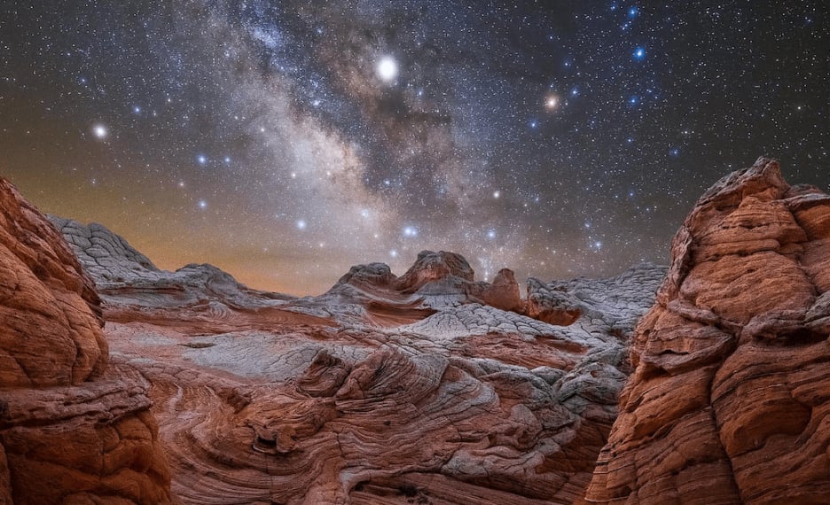
Join renowned photographer Cody York and two expert guides at the captivating White Pocket, a remarkable photographic destination. Immerse yourself in the stunning sandstone landscapes and marvel at the unparalleled night skies. Capture the perfect shot while enjoying short hikes and learning about the geologic history. This all-inclusive trip from Kanab provides transportation, comfortable camping, and delicious home-cooked meals. Enhance your skills with an editing clinic and conclude the adventure with a delightful dinner at one of Kanab's top restaurants. Embark on this unforgettable journey of photography and exploration.
Join your photography instructor Cody York and other guides at Dreamland Safari Tours, located at 406 E 300 S, Kanab, UT 84741 at 10:00am. This is where you’ll also have your gear checked before you grab something for lunch. Around noon, you’ll get a ride to White Pocket. At 2.45pm, it’s time for a 1-hour hiking tour to explore various points of interest. During the afternoon, you’ll have the opportunity to discuss your workshop goals and shooting plan with Cody York, as well as enjoy some free time to explore the area. Dinner will be provided before sunset and Milky Way times, to ensure ample opportunities for golden hour, blue hour, and astrophotography. For fall workshops, shooting typically wraps up before midnight, while for spring workshops, shooting usually starts around 2-3am and seamlessly transitions into sunrise and breakfast. Meals: Dinner

Begin your day with a wake-up call at 5am, accompanied by coffee and muffins to energize you for the sunrise photography session. At 8am, indulge in a hearty full cowboy breakfast to fuel your day. You’ll then have free time to engage in photography discussions, enjoy lunch, and explore the surroundings while planning your next shoot. As the day progresses, capture the mesmerizing sunset through your lens. A delicious dinner will be served before your group prepares you for another night of enchanting astrophotography, just like on day 1. Meals: Breakfast, lunch, and dinner

Experience the magic of early mornings with the last sunrise photography session, starting at 5am. Fuel up with coffee and muffins before capturing the mesmerizing sights. Indulge in a full cowboy breakfast at 8am. As your guides prepare for departure at 8:30am, you’ll have an extra hour to shoot or relax. Leave White Pocket at 9:30am and arrive in Kanab by noon. After checking into your lodging, enjoy free time for a shower and lunch. From 3pm to 7pm, join Cody York for an editing clinic. Finally, gather at 8pm for a closing dinner at one of Kanab’s finest restaurants. Meals: Breakfast and dinner

Meet your guides

We did a two night trip to White Pocket featuring Cody York teaching astro-photography. This is our third trip with Dreamland to White Pocket, so this speaks volumes about our love for the location and our respect for the company. As before, the service provided by Dreamland was exceptional and making an attempt at astro-photography with the incredibly knowledgeable and patient Cody York was rewarding. The Dreamland team consisted of Cody, another professional photographer, one of the owners, and Robert (an excellent chef and willing photo model). The team worked very well together and made the overall experience very memorable. Kudos to Robert for making delicious dinners of chicken, steak and salmon. We had one night of unseasonably cold weather, and we appreciated having our water bottles filled with hot water to tuck in our sleeping bags. We love this area and Dreamland is superb. We’re scheduled for trip #4 with Dreamland in October!
The trip catered specifically to photographers. Venue provided exceptional dark sky. Trip entailed night sky photography on a moonless nights. Introduced techniques to best capture the milky way’s Galactic Core in the South sky. Cody York, the instructor, was spectacular, sharing image capture technique among attendees who had a broad swath of camera equipment. Could have not successfully captured product needed for post processing without the instruction. Cody has gift of being able to multi task among attendees competing for his attention. The image post processing lab IMHO, was absolutely critical to obtain a reasonable end product. The workflow was detailed with many opportunity to get lost, but Cody was there hands on to share his knowledge. Then Dreamland did usual great job of handling the expedition logistics for guiding, feeding, and providing sleeping accommodations for us. In short, doing all the heavy lifting. I am 6′ 4″ and tents provided all room needed for a person and all their gear. I have been a Dreamland customer in the past and plan to keep working with them in the future. Another night sky shoot, if of same caliber as this one, is definitely on my TDL.
Making the third Dreamland Safari Tour I have taken with the company. This particular trip was, yet, another fabulous overnight. This trip, however, was a two night event that featured Cody York teaching us photographic technique in shooting photos of the Milky Way against the White Pockets area in the Vermillion Cliffs. Spectacular adventure for all levels of skills, marvelous hosts and hostess (Sonny) that organized and made things possible. Thanks Robert for pulling out your geology background, insight, information, and cooking skills. Thanks to IRA for he clean equipment and behind the scenes work. Thanks to Dreamland Safari for the concept of the photo journey and thanks to Cody for the relentless effort in making it all possible.
What you get on this adventure:
- 1:1 teaching by your guide and photographer Cody York
- An assistant instructor (based on group size)
- Two guides from Dreamland Safari Tours to ensure your comfort at camp
- 3-day guided White Pocket photography tour
- Photography lessons — optimal photographic timing to capture sunset, sunrise, and some of the best night skies in the continental U.S.
- All meals once tour departs — excellent camp-cooked meals and a goodbye dinner
- Accommodation in a comfortable camp
- Transportation during the tour — safe, comfortable 4×4 transport on rough dirt roads
- 4-hour post-processing session in Kanab
- Wilderness First Responder Guide and satellite messenger in case of emergency
What’s not included:
- Transportation to Kanab
- Canyons Boutique or Canyons Lodge are recommended for the quality of their accommodations and proximity to the editing clinic and final dinner
- Any meal not listed in the itinerary
- Guide gratuities
- Alcoholic beverages
There are no special skills needed for this guided White Pocket Tour. Though the focus of this trip is on photography, there’s still some hiking featuring uneven footing and optional mild scrambling. The area is very close to the camp so it’s up to you how much you want to hike and explore—there will be lots of free time to discover the spectacular landscape.
Here’s a list of the equipment you need to bring:
- Backpack large enough to carry all the items listed (around a 55-65L bag)
- Camera and any relevant photography gear
- Water bottles or hydration bladders (3L capacity)
- Quality, durable hiking boots
- Hiking attire
- Spare clothes for layering
- Waterproof rain jacket
- Headlamp or flashlight
- Toiletries (sunscreen, hand sanitizer, bug spray, toilet paper, etc.)
Dress comfortably and for the weather in clothes you can move in. We suggest bringing clothing appropriate for the season.
Your guide will secure sleeping bags for every participant.
Group sizes and prices:
- For this photography White Pocket tour, the maximum group size is set at 8. There will be two experienced guides as well as a photographer Cody York and his assistant.
- The cost does not decrease as the group grows.
Photography trip at White Pocket can be arranged for larger groups. Contact us to make arrangements.
Min. age requirements:
- If you are older than 18, you’re good to go.
- Minors younger than 18 may be permitted to join the hike on a case-by-case basis, but must be in the presence of a parent or legal guardian.
If your group has hikers under the age of 18, contact us prior to booking to make arrangements.
There are multiple options to reach Kanab, the starting point of your tour. Most people fly into one of these three major airports: Harry Read International Airport (LAS) near Las Vegas, Salt Lake City International Airport (SLC) , and Phoenix Sky Harbor International Airport (PHX) . From there, the best option would be renting a car—depending on the chosen airport, it will take you anywhere between 3 and 5.5 hours to get to Kanab.
Meet your White Pocket photography instructor and other guides and go through your gear check at 10am on Day 1 at 406 E 300 S, Kanab, UT 84741, next door to the Travelodge. Guests may leave cars or extra bags here. Arrange your travel accordingly.
57hours is committed to providing safe outdoor adventure experiences. We require all guides using our platform to have a COVID-19 safety plan and to make the details of that plan accessible to travelers. In most cases, group sizes will be reduced, guides will avoid overcrowded locations, and other safety measures will be met depending on the location and activity.
We also expect clients to respect local regulations and take measures to protect themselves, their guides, and the communities they’re traveling to. For more information on COVID-19 measures in Arizona, please refer to COVID-19 travel info .
Please contact us if you have any questions or require further information. We are happy to provide you with the most up-to-date information!
A 50% deposit to secure your place is due upon booking. The remaining amount is paid 1 month (30 days) prior to departure. Once the trip is confirmed by the guide, the cancellation policy stated below applies.
- If Client cancels the Booking anytime prior to ninety-one (91) calendar days in advance of the trip contemplated by the booking, Client is entitled to a full refund minus a $100 fee.
- For cancellations sixty-one (61) to ninety (90) calendar days in advance, Client is entitled to a refund in the amount of 80 percent (80%) of the full tour price.
- For cancellations thirty-one (31) to sixty (60) calendar days in advance, Client is entitled to a refund in the amount of seventy (70%) of the full tour price.
- For cancellations eight (8) to thirty (30) calendar days in advance, Client is entitled to a refund in the amount of sixty percent (60%) of the full tour price.
- For cancellations forty-eight (48) hours to seven (7) calendar days in advance, Client is entitled to a refund in the amount of thirty (30%) of the full tour price.
- After that deadline, Client is not entitled to any refund. Any reimbursable expenses arising out of the Booking incurred by Guide prior to the date of cancellation (including but not limited to plane tickets, car rental payments, and lodging or transportation fees) are non-refundable as soon as they are incurred by the Guide.
Other things to do in Utah

Zion National Park Hiking Tours

Canyoning near Zion National Park

Hiking in Arches and Canyonlands NPs in Moab

Women’s Hiking Through the Paria Canyon

Hiking and Camping Tour of Zion National Park

Hiking the Narrows in Zion National Park

Angel’s Landing Guided Hike

Hiking in Bryce Canyon

Hiking Through the Paria River Canyon
View all (52) adventures in Utah
Choose a currency
- USD - $ US Dollar
- EUR - € Euro
- AUD - AU$ Australian Dollar
- CAD - CA$ Canadian Dollar
- GBP - £ British Pound Sterling
- CHF - CHF Swiss Franc
- JPY - ¥ Japanese Yen
- SGD - S$ Singapore Dollar
- HKD - HK$ Hong Kong Dollar
- DKK - Dkr Danish Krone
- NOK - Nkr Norwegian Krone
- SEK - Skr Swedish Krona
(435) 644-5506
- Multi-Day Tours
White Pocket Overnight Photography Tour
Fully Guided Tour
Photography Paradise!
Interesting Geology!
Other Paria / Vermillion Cliffs Tours
The Wave Tour
White Pocket Tour
South Coyote Buttes Tour
Other Overnight Tours
Alstrom Point Overnight Photography Tour
Exclusive Photo Workshop with Cody York at White Pocket
Grand Canyon – Overnight Toroweap / Tuweep Photography Tour
We go out of our way to open the wonders of the West to EVERYONE .
We are permitted, licensed, and insured.
Dreamland Safari Tours holds Special Use Permits from the Grand Staircase Escalante National Monument , Grand Canyon National Park , the Vermilion Cliffs National Monument/Paria Wilderness , Glen Canyon National Recreation Area , Kanab Bureau of Land Management, Kaibab National Forest , and Arizona Strip Bureau of Land Management .

Don't see your preferred departure date or time available via online booking? Give us a call.
For sunset or sunrise at our more remote locations, we recommend a scheduled or custom overnight or multi-day tour - and we are happy to work with you to develop an itinerary that meets your needs.
All listed tour durations and pickup times are approximate. Please allow 10-20 minutes of pickup time flexibility for unforeseen circumstances and varying pickup logistics. Water and snacks are provided on all tours. A lunch meal is included on all tours of 6+ hours. Vegetarian option available.
We reserve the right to fill all empty seats on non-private tours. Cancellation / Reschedule / Weather policy applies.
Please familiarize yourself with our FREQUENTLY ASKED QUESTIONS before contacting us.
To contact us with other specific questions or begin Making Reservations click the " Book Now " Button on each tour page or click Contact Us for info on how to give us a call or shoot us an email.

Our Overnight White Pocket Photography Tour allows photographers, couples, and other adventurers to optimize the full cycle of daylight at this wondrous expanse of contorted, multi-color sandstone.
- Trip Details
Private Tour Upgrade Available?
Tour length, departure times, difficulty (1-10), recommended abilities, attractions, special interests, what is included on your tours.
Daytours include pickup and dropoff from local hotels, off-road transportation, natural history narration, guided hiking, photo advice, snacks, water, and lunch on tours of 6 hours or more. Our multi-day tours include all of this plus camping equipment, camp management, three excellent meals, stargazing, sunsets and sunrises for the photographer, and lots more time outside.
How soon should we book?
This depends on several factors, but our best advice is to book as soon as you finalize your plans. We do fill up, and if you have a limited window of opportunity, you may miss out. The smaller your availability window and the tighter your schedule, the earlier you need to book in order to ensure availability. The larger your group, especially if it involves more than one of our trucks (>7 passengers), the earlier you need to book.
How do I reserve my date(s)?
You are able to book online or by contacting us. We do require a 50% deposit to reserve your daytour date(s) and a 1/3 deposit to reserve a multi-day tour. The remaining balance is due the day of your tour at departure. Your guide can take any method of payment.
Can I pay via cash, Paypal, credit card, check?
What is your weather policy what is your cancellation/reschedule policy.
These policies are all found on our Policies Page . PLEASE NOTE: Because of the constantly changing weather, targets moving over the whole region (our trucks), unpredictability of weather forecasts, the complexities of different road surfaces in different areas, the variable nature of storms as far as coverage and volume in this area, and the fact that some of the best photography weather is often on days with a chance of rain, we do not reflexively cancel tours without solid information. However, as your safety is always paramount in situations where incontrovertible evidence leads us to believe that potentially dangerous situations are probable, we will cancel tours if necessary. We will assume tours will run until departure time. We do not cancel tours until departure time as the most relevant information is at hand. Also if we know of a particular area or time that will be a problem we will often consult with all parties on the tour as to how best to go about re-routing, postponement, or cancellation. Trying to manage this on the phone hours before the tour is nearly impossible. If a party decides to cancel prior to departure time for reasons of weather forecasts, the cancellation will be subject to the standard policy. Cancellations made by us at departure will be accompanied by a full refund if no other solution can be reached. Also the information we have at any given time is often incomplete. For example, we do not know if the Wave is covered in snow or if the route is hikeable, whether roads are impassable in a given location etc….as we do not have a webcam at these remote locations. We do try to network to get better information if we can. Sometimes incontrovertible evidence is only found once the tour has begun. Guessing, followed by reflexive cancellations, we have learned, produces more poor results for everyone involved, than the strategy we take. It is very, very complex making these decisions. We are always monitoring the weather and have many years of experience managing the logistics that are affected by weather in this area. Please trust us to act in both our best interests.
What kind of vehicles do we tour in? Do you offer ATV/Jeep Tours?
All of our tours are run in Chevrolet Suburbans or Crew Cab Silverados for comfort and safety. We do not offer ATV or Jeep Tours.
What do I need to bring on a daytour/overnight?
The biggest things you need to remember on a daytour are a small pack to carry your own water (essential especially on tours with more hiking), jacket for warmth and rain (essential), boots or high top sneakers (optional but optimal in sand), any essential medication, and camera. Other items include extra layers when cold, hat, sunglasses, sunscreen, chapstick, and other typical daytime sundries. For scheduled overnights bring all the same except an extra layer or two. You do not need a change of clothes. For overnights in April or October bring a warm hat and gloves. For custom multi-day trips just add a change of clothes or two. On all tours we provide water and snacks. On daytours of more than 6 hours and multi-days more than 24 hours we provide lunch. On scheduled overnights of 24 hours we do not provide lunch so please eat before you come.
What is the weather like there at various times of year?
You can find average monthly temperatures and precipitation for Kanab HERE and also read our BLOG POST on the topic.
We want to do one of your overnight tours, but aren’t able to make any of your scheduled dates. What are our options?
Depending upon our schedule, we may be able to add or shift dates. Please contact us with which tour you are interested in and which dates you are considering. Custom multi-days can be arranged APR-OCT depending on availability.

Because White Pocket is fast becoming a top photography destination, many times our guests want to stay late and/or arrive early to get the best light. Some of the most hardcore even stay up round the clock doing night photography, including star trails and Milky Way Shots.
Our Overnight White Pocket Photography Tour lets you get them all in this remote corner of Arizona on the Paria Plateau. While this tour is often offered on a custom basis to larger groups, we also schedule several standing dates so that couples and singles can take advantage of this prime Arizona Photography Tour.
This tour includes:
- Lots more time to enjoy this world class landscape photography venue
- Optimal photographic timing to capture sunset, sunrise, and some of the best night skies in the continental United States.
- Excellent home-cooked meals for dinner and breakfast. No lunches included.
- Comfortable camp environment with toilet, tables, chairs, campfires when possible, tents, air mattresses, sleeping bags, and down comforters when cold.
- Safe, comfortable 4×4 transportation on rough dirt roads.
- Wilderness First Responder Guide and satellite messenger in case of emergency.
The Overnight White Pocket Photography Tours currently scheduled are listed below. Sometimes dates are added, removed, or shifted so check back from time to time. If you wish to book this tour click the “Book Now” button below to get started with online booking or give us a call at 435-644-5506. Also please give us a call if you do not see your desired dates below. Overnight season is April-Oct.
The Wave Tour with Wire Pass Slot Canyon
White Pocket / South Coyote Buttes Combo Tour
12:00pm – Guests meet at at 406 E 300 S, Kanab, UT 84741 , next door to the Travelodge. Guests may leave cars or extra bags here.
2:45pm – Guide orients the group to the White Pocket Area and leads a 1-hour hiking tour to various points of interest then returns to camp to set up. Guests have free time until dark/dinner.
7:45 – 8:45pm – Sunset Photography (timing varies)
9:15pm – Dinner (timing varies, but late dinner allows for sunset photography until dark)
10:00pm – bedtime – Clean up, campfire, discussion, relaxation, astronomy, night photography
5:00am – Wake up Call, Coffee, Muffins
6:30 – 7:30am – Sunrise Photography
8:00am – Full Cowboy Breakfast
8:30am – Guide packs up while guests get 1 more hour to shoot or relax
9:30am – Depart White Pocket
12:00pm – Arrive in Kanab
Guest Experiences on the White Pocket Tour
Steve was an awesome guide and we had a great time hiking White Pocket (Vermillion Cliffs) with him. He customized our hike and planned a great route for us. Since we liked birds he stopped at the California Condor viewing area for us. We got to see 900 year old drawings and then amazing views of the white pocket are from different angles. Lunch was yummy with fresh veggies, fruit and meat. Fantastic Day, highly recommend.
DABEDB – May 20, 2019 TripAdvisor
Best tour ever. Such a beautiful natural wonder! The journey there and back was also amazing. Andrea was an excellent guide pointing out all kinds of interesting features of the landscape. Her driving was swift and safe in a well maintained all wheel drive vehicle. I would not want to attempt this trip on my own even with a adequate all wheel drive vehicle. White Pocket itself is simply stunning. I would recommend this tour to anyone who appreciates natural wonders.
I8990KDrobertr – May 16, 2019 TripAdvisor
Took a tour of White Pocket with Dreamland at the end of April with Andrea as our tour guide. It was a great experience. White pocket is very difficult to get to – both in terms of terrain and directions. Having a guide to get you there safely, as well as give some interesting history and facts on the area was great. Would definitely recommend!
Jamie U – May 12, 2019 TripAdvisor
Bailey did a great job for our small group. My wife and I enjoyed everyone’s company as well as the good lunch prepared for us. It takes a while to get out to White Pocket, but you will be glad you made the effort to see this fascinating area.
Departure68316626825 – May 10, 2019 TripAdvisor
Just completed a truly wonderful visit to White Pocket on a photo safari with Dreamland and AZ Highways Photo Tours. Dreamland’s outfitters were outstanding. Food was almost too good and plentiful. Their service and attention to detail is outstanding. Not sure when my next trip is with them but I’m already looking forward to it!
Terry G – May 7, 2019 TripAdvisor
About White Pocket
White Pocket has gained notoriety only recently as a photographer’s playground and world-class hiking destination. It is the perfect alternative to the Wave in North Coyote Buttes and White Pocket lies less than 6 miles away from that famous feature. The colorful stripes and otherworldly rock shapes provide infinite opportunity for photography, and the hiking is much easier than at the Wave. The White Pocket formation itself is 0.7 of a mile across, which doesn’t sound very big, but the gorgeous striations are quite condensed. And it is much bigger than the actual Wave, which is about 2 acres in size.
At White Pocket, the view changes constantly and curious hikers will want to peer around every corner and climb up onto each high point. Those who really appreciate natural beauty have spent a full day exploring White Pocket and felt like they barely scratched the surface. Our guides still uncover fascinating details after scores of trips there.
The Grand Staircase provides a vast and gorgeous backdrop for White Pocket’s intense swirls and white polygonal brain rock. Look out past White Pocket to the brilliant red sandstone of the Coyote Buttes, the Cockscomb, the landmark known as Molly’s Nipple, the Kaibab Plateau and the colorful layers of the Grand Staircase.
Getting to White Pocket
The Jurassic age sandstone formation is situated on the remote and rugged Paria Plateau in the Vermilion Cliffs National Monument in Arizona, less than three miles from the Utah border. Its remoteness ensures you won’t encounter crowds here. In fact, on most days there are only a handful of cars at the trailhead. It’s easy to find a secluded spot at White Pocket where you will hear and see no one.
Roads on the Paria Plateau are unmaintained and are comprised of deep sand with rocky sections scattered throughout. A four-wheel drive vehicle with good ground clearance and off road tires is a must. Some experience driving in deep sand can really come in handy, especially in summer when the sand is dry, soft and deep. We lower our tire pressure to power through the sections of deep sand. It takes at least 2.5 hours from Kanab or from Page to get to White Pocket. On our tours, we try to make a loop drive out of the trip when we can, depending on road conditions, weather and our pick up locations. On our preferred route, we take 89A out of Kanab heading through Jacob Lake and then we enter House Rock Valley from the south, where we stop at a California Condor release site to look for the endangered raptors. From there, we turn onto BLM 1017, often called Corral Valley Road, which heads up onto the Paria Plateau. This is where maintained roads end. When we reach Pine Tree Pocket, we veer north and traverse about 10 more miles of sandy roads to White Pocket.
On our way home, depending on weather, we may exit the Vermilion Cliffs National Monument through the north end of House Rock Valley where we catch the gorgeous Vermilion Cliffs and the brilliant East Kaibab Monocline (Cockscomb) in the soft, afternoon light.
It’s a long drive to White Pocket, there is no way around it, but the variety of scenery on the way is incredible and the feeling of remoteness in itself is a real thrill. These roads are remote, sandy and not clearly marked. We rarely bring guests to White Pocket who later say they would have been comfortable navigating the roads on their own.
White Pocket Geology
Rewind 190 million years and imagine a hot, dry desert with gigantic sand dunes stacking up in the brisk wind. White Pocket is comprised of Navajo sandstone that got its start as towering dunes back in the early Jurassic Period. Back then, the area was much closer to the equator than it is today. As the dunes were buried under more and more sand, they became saturated with groundwater. Slowly, groundwater minerals cemented the sand grains together, turning the dunes to stone. But that’s only part of the story. Something happened here, a major ground disturbance – perhaps an earthquake that triggered an underground landslide – that caused layers of sediment to separate, fold and become sheared while the sand was saturated with water and before it had turned to stone. Geologists call this soft sediment deformation. The result of the massive sand slide is wildly contorted and twisted rock. The specifics of how some of the formations came to be stump the most experienced geologists.
There are many shades of red, pink and yellow that are caused by the oxidation of iron-bearing minerals. Pink hues in the rock often indicate the presence of hematite, while limonite appears yellow or brown. The white coating over White Pocket is calcium carbonate.
There are several theories about how the polygonal cracks in the “brain rock” came to be, including thermal contraction, moisture cycles and drying processes of the sandy sediments and tensile forces. Similar cracks have been observed elsewhere on the Colorado Plateau and even on the moon. Guests sometimes say it feels like you’re walking on the back of a giant white dragon or strolling across the surface of the moon. Another “otherworldly” feature found at White Pocket is Moqui marbles. The marble-like concretion has a sandstone center encased in an iron oxide shell. Scientists say iron was dissolved into ground water 50 million years ago and collected to form sphere shaped iron concretions. In 2004, two Mars rovers landed on the Red Planet and sent back images of BB sized formations similar to Moqui marbles. NASA scientists call them Martian blueberries. NASA studied Moqui marbles on the Colorado Plateau to learn how they form, wondering if this could provide evidence of water on Mars. Results are inconclusive. The Martian blueberries may have been caused by meteorites. But walking around the bizarre landscape at White Pocket, it’s easy to imagine a connection between it and Mars. Rock gathering in the national monument is not allowed.
Human History
Humans have probably been visiting White Pocket since the ice age when nomadic hunters wandered the expansive landscape in search of large game. The Paria Plateau is also home Native American ruins dating back to the Pueblo Periods from about 750 A.D to 1250 A.D. Pottery fragments and arrowhead flakes can be found in the sand surrounding White Pocket. Ancient corn cobs and petroglyphs depicting desert bighorn sheep and deer have been found in the vicinity. More recently, ranchers settled and grazing began somewhere around 1840. On the dry plateau, ranchers often drew water from underground springs using pumps powered by windmills. One such windmill, now out of commission, is seen along Corral Valley Road at Corral Valley Pockets. The word ‘pocket’ is a ranching term for a place that holds water. That’s how White Pocket got its name. Way before we sightseers showed up with our cameras, cattlemen were watering their stock in pockets of water on the formation. They even built two concrete dams in 1929 to increase the water capacity of the water pockets. Today, we enjoy these reflective pools for their incredible photographic potential and for their fascinating wildlife. Fairy shrimp, tadpoles and triops are often spotted in the pools.
While ranchers no longer live on the plateau and the land is in public hands, cowboys can still occasionally be spotted rounding up cattle on horseback. One family has ranched the plateau for four generations. Most of the roads on the Paria Plateau were created by ranchers who needed to mend fences and water their cattle. Other signs of ranching are evident: corrals, old abandoned trucks, broken windmills, and cowboy graffiti are signs of a different time. Richard Faye Hamblin (1908-1976) is one cowboy who signed his name on the plateau, on a sandstone wall near White Pocket.
Contact Us for a Private Tour - White Pocket Overnight Photography Tour
Dreamland women's adventure award application / nomination.
Know a woman who could use a fresh-air getaway to Southern Utah at close to no cost? Nominate her (or yourself!) today. You are welcome to nominate more than one individual by submitting multiple nomination forms. The Women's Adventure Award weekend takes place from March 1-3 2024 and includes a full-day hiking adventure with Dreamland Safari Tours, two nights of lodging, meals, and more. Adventure Award recipients are responsible for their own travel to/from Kanab and need to plan to arrive in Kanab by 4pm on the afternoon of Friday March 1.
- Your Name * First Last
- Your Email * Enter Email Confirm Email
The Spirit behind the Women's Adventure Award
About the woman you are nominating.
- Nominee's Name * First Last
- Nominee's Email Address * Enter Email Confirm Email
- Nominee's City & Country City Afghanistan Albania Algeria American Samoa Andorra Angola Anguilla Antarctica Antigua and Barbuda Argentina Armenia Aruba Australia Austria Azerbaijan Bahamas Bahrain Bangladesh Barbados Belarus Belgium Belize Benin Bermuda Bhutan Bolivia Bonaire, Sint Eustatius and Saba Bosnia and Herzegovina Botswana Bouvet Island Brazil British Indian Ocean Territory Brunei Darussalam Bulgaria Burkina Faso Burundi Cabo Verde Cambodia Cameroon Canada Cayman Islands Central African Republic Chad Chile China Christmas Island Cocos Islands Colombia Comoros Congo Congo, Democratic Republic of the Cook Islands Costa Rica Croatia Cuba Curaçao Cyprus Czechia Côte d'Ivoire Denmark Djibouti Dominica Dominican Republic Ecuador Egypt El Salvador Equatorial Guinea Eritrea Estonia Eswatini Ethiopia Falkland Islands Faroe Islands Fiji Finland France French Guiana French Polynesia French Southern Territories Gabon Gambia Georgia Germany Ghana Gibraltar Greece Greenland Grenada Guadeloupe Guam Guatemala Guernsey Guinea Guinea-Bissau Guyana Haiti Heard Island and McDonald Islands Holy See Honduras Hong Kong Hungary Iceland India Indonesia Iran Iraq Ireland Isle of Man Israel Italy Jamaica Japan Jersey Jordan Kazakhstan Kenya Kiribati Korea, Democratic People's Republic of Korea, Republic of Kuwait Kyrgyzstan Lao People's Democratic Republic Latvia Lebanon Lesotho Liberia Libya Liechtenstein Lithuania Luxembourg Macao Madagascar Malawi Malaysia Maldives Mali Malta Marshall Islands Martinique Mauritania Mauritius Mayotte Mexico Micronesia Moldova Monaco Mongolia Montenegro Montserrat Morocco Mozambique Myanmar Namibia Nauru Nepal Netherlands New Caledonia New Zealand Nicaragua Niger Nigeria Niue Norfolk Island North Macedonia Northern Mariana Islands Norway Oman Pakistan Palau Palestine, State of Panama Papua New Guinea Paraguay Peru Philippines Pitcairn Poland Portugal Puerto Rico Qatar Romania Russian Federation Rwanda Réunion Saint Barthélemy Saint Helena, Ascension and Tristan da Cunha Saint Kitts and Nevis Saint Lucia Saint Martin Saint Pierre and Miquelon Saint Vincent and the Grenadines Samoa San Marino Sao Tome and Principe Saudi Arabia Senegal Serbia Seychelles Sierra Leone Singapore Sint Maarten Slovakia Slovenia Solomon Islands Somalia South Africa South Georgia and the South Sandwich Islands South Sudan Spain Sri Lanka Sudan Suriname Svalbard and Jan Mayen Sweden Switzerland Syria Arab Republic Taiwan Tajikistan Tanzania, the United Republic of Thailand Timor-Leste Togo Tokelau Tonga Trinidad and Tobago Tunisia Turkmenistan Turks and Caicos Islands Tuvalu Türkiye US Minor Outlying Islands Uganda Ukraine United Arab Emirates United Kingdom United States Uruguay Uzbekistan Vanuatu Venezuela Viet Nam Virgin Islands, British Virgin Islands, U.S. Wallis and Futuna Western Sahara Yemen Zambia Zimbabwe Åland Islands Country
- Tell us about your nominee. * Why should she (you?) receive the Dreamland Women's Adventure Award?
- The IWD Adventure Award intends to recognize women who are advocates for female participation and leadership in their community, and inspire others * What example of leadership accomplishments, community involvement, or impactful projects can you share with us that will give us a better understanding of how your nominee contributes to her community?
- Optional: What impact has the nominee had on your life? If you have a personal story to share, don't hold back. If you are nominating yourself, you don't need to answer this question (unless you really want to!).
The Fine Print
- Your nominee is in good physical condition and able to hike 5+ miles in a day.
- Your nominee would enjoy a desert adventure hike among a small group of like-minded women.
- Your nominee is in a position to travel to Utah and spend Friday March 1 - Sunday March 3 2024 in Kanab (must arrive by 4pm on Friday)
Thanks for your nomination!
- Phone This field is for validation purposes and should be left unchanged.
Contact Us for a Private Tour - Overnight Toroweap Photography Tour

Dreaming of epic desert adventures?
Stay in the loop to find out when we add new hiking destinations, backpacking trips and photo workshops. We won't spam you.
2018 Primetime Emmy & James Beard Award Winner
R&K Insider
Join our newsletter to get exclusives on where our correspondents travel, what they eat, where they stay. Free to sign up.
A History of Moscow in 13 Dishes
Featured city guides.
IMAGES
COMMENTS
Our White Pocket Tour in extreme Northern Arizona guides you through a gnarled expanse laid bare right at the transition between the white and reddish orange sandstone. It has twists, multi-color striations of white, yellow, red, orange, and pink, pock marks and pools that sometimes fill with water, mushroom like protrusions, strange bulges ...
WHITE POCKET FURTHER TOUR. This tour begins at White Pocket but does not have to include it. There is a lot of hiking involved but we will take you into another area with great fins and many types of different formations including lots of "brain rocks". No permit needed. $200 + TAX per person ($220 TOTAL)
White Pocket is a unique landscape where we wander around in the 1.5 square miles of white "brain rock", and take in the amazing red, yellow, and orange swirls erupting out of the otherwise uniform out of this worldly formation. White Pocket offers a variety of formations and colors. It is our most popular 7-8 hour tour.
How to Get to White Pocket from Page Arizona. To get to White Pocket from Page, Arizona, take Highway 89A west for 36 miles. You will meet up with House Rock Valley Road 13.5 miles east of Jacob Lake, Arizona. After turning onto House Rock Valley Road, head north for 9.3 miles until you get to BLM 1017 and go east.
Tour Details. Your guide will meet you and transport you, along with the ATVs, to the tour departure point, House Rock Valley Road (this takes 45 minutes), which accesses the trails that lead to White Pocket.; We'll bring along plenty of iced water but won't provide lunch or snacks. We recommend that you bring along high energy snacks and a filling sandwich which you can store in our cooler.
No permit is required for White Pocket. Accessible only by 4 wheel drive, so leave the driving to us, while you enjoy the ride in our comfortable 4X4. Tour time: about 8 hours (Day); about 24 hours (Overnight) Departure times: Flexible-day tours, sunset tours, and overnight tours are available. Sandwiches, snacks, cold drinks and bottle water ...
Spectacular vistas created by the heady mix of a few lone trees, a bursting colorful palette, and a variety of sandstone formations await photographers and sightseers alike on our epic White Pocket tours. After grabbing a coffee together, we'll set out down Highway 89A on a winding, scenic journey to remember through the Kaibab National Forest.
Directions To White Pocket from Kanab, UT, or Page, AZ: Highway 89 to House Rock Valley Road. House Rock Valley Road - south for 23.5 miles. Watch for the old horse corral. BLM Road 1017 - east for 6 miles. BLM Road 1087 - northeast.
Getting to White Pocket from Page - The Best Route. If you're coming from Page, it's about a 2 hour and 40-minute drive to White Pocket. Head east on Highway 89 until you reach an unassuming dirt road exit for House Rock Valley Road.
White Pocket. Remote region of the Paria Plateau; swirling, multicolored formations of Navajo sandstone, including domes, hoodoos, gullies and potholes. Reached by a long drive on unpaved roads, some requiring a high clearance 4WD vehicle. Length: around 2 miles (round trip) Elevation change: up to 200 feet. Difficulty: Easy. Type: Off-trail loop.
White Pocket is located inside the Vermillion Cliffs National Monument, with the closest town being Kanab, Utah. It's part of the Coyote Buttes area, along with a much better-known attraction: The Wave, which lies just six miles northwest. The Wave, however, has become so popular that a strict lottery system was implemented several years back.
We offer three different full-day tours of the area. Tours depart from our office location: 22 South Lake Powell Blvd - Page AZ 86040. TOUR OF WHITE POCKET The real gem of the Vermilion Cliffs and surrounding area. Simply put, our trip to White pocket will show you the most scenic place and most unusual geology in this region. This is an 8 ...
White Pocket Tour. Length: 2-3 Miles. Difficulty: Easy. Cost: $269.00 - 2 person minimum. ($135 Child) Book Now. The White Pocket guided tour in the Vermilion Cliffs National Monument is the go-to spot for the serious photographer. Grand Circle Tours has been exploring this area for over ten years, and we've identified several top sites which ...
White Pocket is a section of the Paria Plateau in Vermillion Cliffs National Monument. While this national monument is famous for "The Wave" hike, White Pocket is the true hidden gem that is one of the best things to do in Page, Arizona. This incredible group of rock formations includes crazy swirls of color, pockets in the rock created ...
Itinerary. Day 1. 10:00am - Meet & greet and gear check with Cody at Dreamland Safari Tours at 406 E 300 S, Kanab, UT 84741, next door to the Travelodge. Guests may leave cars or extra bags here. 11:15am - time to pick up lunch (not included in workshop cost) Noon - Begin transfer to White Pocket. 2:45pm - Guide orients the group to the ...
White Pocket is a must-see gem in Vermillion Cliffs National Monument, Arizona. Known for its striking resemblance to its Utah counterpart, The Wave, visiting White Pocket boasts equally fascinating rock formations! Embarking on a journey to this extraordinary place to visit near Utah demands more than a sense of adventure. Navigating the road to get there requires a high-clearance 4WD vehicle ...
Two guides from Dreamland Safari Tours to ensure your comfort at camp; 3-day guided White Pocket photography tour; Photography lessons — optimal photographic timing to capture sunset, sunrise, and some of the best night skies in the continental U.S. All meals once tour departs — excellent camp-cooked meals and a goodbye dinner
Walking tour around Moscow-City.Thanks for watching!MY GEAR THAT I USEMinimalist Handheld SetupiPhone 11 128GB https://amzn.to/3zfqbboMic for Street https://...
1: Off-kilter genius at Delicatessen: Brain pâté with kefir butter and young radishes served mezze-style, and the caviar and tartare pizza. Head for Food City. You might think that calling Food City (Фуд Сити), an agriculture depot on the outskirts of Moscow, a "city" would be some kind of hyperbole. It is not.
The Overnight White Pocket Photography Tours currently scheduled are listed below. Sometimes dates are added, removed, or shifted so check back from time to time. If you wish to book this tour click the "Book Now" button below to get started with online booking or give us a call at 435-644-5506.
There are many options for touring the city, including by bus, by foot, or by boat. Th Free Moscow Free Tour ( www.moscowfreetour.com) are run by English-speaking guides, and allow you to relax while touring around the highlights of the city. It's all free, and even includes a free cup of coffee or "kvas" and free wi-fi on the bus!
This tour of Moscow's center takes you from one of Moscow's oldest streets to its newest park through both real and fictional history, hitting the Kremlin, some illustrious shopping centers, architectural curiosities, and some of the city's finest snacks. Start on the Arbat, Moscow's mile-long pedestrianized shopping and eating artery ...