Perfect Mt St Helens day trip from Seattle or Portland
Last Updated on July 1, 2023
Are you a volcano lover? Nature lover? If so then you absolutely must do a Mt St Helens day trip if you are anywhere near Seattle or Portland. On May 18, 1980, Loowit (Mt St Helens) erupted with incredible force, enough to incinerate miles of forest, unleash an epic mudslide that took out part of Interstate 5 and send an ash cloud miles into the sky that blocked out the sun for much of the west and sent ash traveling around the entire globe multiple times.
June 2023 Note : State Route 504, the Spirit Lake Highway, experienced a landslide in the Spring 2023 and the road is closed to Johnston Ridge Observatory. I will update this once they announce when the road and Johnston Ridge will reopen.
Loowit (Mt St Helens) is a fascinating place to learn about the destruction of the 1980 volcanic eruption and how life returns. You can hike trails, explore epic views, and learn about the science of volcanoes and how ecosystems change and recover after such a disruptive event. It’s an incredible experience that you won’t find anywhere else in the world!
Loowit means “smoking mountain” and is the homeland of the Cowlitz People and the Klickitat People.
Passes Needed : Monument Pass (purchase at the Johnston Ridge Observatory) – $8 per adult (free if you have an annual federal lands pass)
Cell Service : None along the Spirit Lake Highway or in Mt St Helens National Monument.
Dog Friendly : Dogs are not allowed on trails in Mt St Helens National Monument. In addition there is no shade at the Johnston Ridge Observatory so it is not safe to leave your dog in the car either. I recommend NOT bringing your dog to Mt St Helens.
Accessibility : Johnston Ridge has a ADA accessible parking and an ADA accessible restroom as well as a short accessible hiking trail through the destruction of the blast zone. Seaquest State Park also has accessible restrooms, parking an an ADA accessible trail.
Services : Make sure you have a full take of gas and bring plenty of food and water with you. Once you leave I-5, there are no services.

When is the best time to visit Mt St Helens?
- How do you get to Mt St Helens from Seattle?
- How do you get to Mt St Helens from Portland?
Johnston Ridge Observatory
Coldwater lake, forest learning center.
- Buried A-frame and Bigfoot statue
Silver Lake Visitor Center and Seaquest State Park
- Hikes at Mt St Helens
Windy Ridge
- Climbing Mt St Helens

Summer is the best time to visit Mt St Helens, since it really isn’t accessible in the winter. The Spirit Lake Highway which takes you from I-5 to Johnston Ridge is only open in the summer, generally mid-May through October.
I recommend going in July because that gives you the best chance of clear weather, no lingering snow and not too much haze yet. June, August and September are also excellent times to go. If you are not a fan of hot weather, I recommend September because it is a bit cooler than July.
July has stunning wildflowers at Johnston Ridge.
Much of Mt St Helens National Monument has no trees and no shade so it can be VERY hot. Make sure to bring plenty of water and sun protection!
How to get to Mt St Helens from Seattle
Mt St Helens is a long drive from Seattle and if you’re a camper, you might want to consider spending the weekend at Seaquest State Park. You can still do a Mt St Helens day trip from Seattle, no problem!
Head south on I-5 past Chehalis. South of Chehalis, take Exit 68 for US Highway 12. I recommend a short but worthwhile detour and leg stretch to Lewis and Clark State Park. This small state park has an impressive stand of old growth trees like the many that were leveled in the Mt St Helens 1980 eruption. When I did day trip tours to Mt St Helens from Seattle, we always stopped here so people could see the kinds of ancient forest that once existed in the volcanic landscape before the eruption.

There’s a short nature trail that gives you a chance to stretch your legs and use the restroom a couple hours into your trip which is a good time for a break. A Washington Discover Pass is needed to park here.
Once you exit I-5 on to Highway 12, look for Jackson Highway on the right in 4.5 miles. This will take you straight to Lewis and Clark State Park in just a couple miles.
When you leave Lewis and Clark State Park, continue south on Jackson Highway for five miles and then turn left onto State Highway 505. In 14 miles, turn left on State Highway 504, the Spirit Lake Highway. If you want to check out Silver Lake or Seaquest State Park, take a right here to back track about 12 miles. You can also return this way back to the freeway, although it’s slightly longer.
The Spirit Lake Highway takes you straight to the Johnston Ridge Observatory
Driving time from Seattle to Johnston Ridge Observatory (without stops) takes about 3 hours .
How to get to Mt St Helens from Portland
Mt St Helens is a shorter drive from Portland. To get there, take I-5 north into Washington and take exit 49 in Castle Rock. Turn right on State Highway 504, the Spirit Lake Highway. The Spirit Lake Highway dead ends at the Johnston Ridge Observatory.
Driving time from Portland to Johnston Ridge Observatory (without stops) takes about 2 hours .
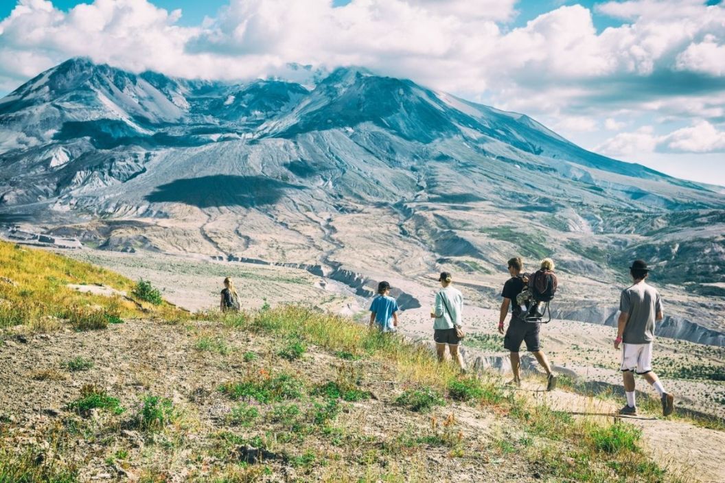
Things to do on a Mt St Helens day trip

Johnston Ridge Observatory is named for the late volcanologist David Johnston, who’s famous radio broadcast told alerted the scientific community that the expected eruption was happening, just moments before he died in the eruption. Once you arrive, it’s easy to see why this was the perfect place to observe the volcano as it became more active in early 1980.
Today, the observatory has exhibits as well as an excellent movie about the eruption and the way the ecosystem is recovering from the eruption. Make sure to stay all the way through the credits because at the end the curtain pulls up to show a dramatic view straight into the crater of Mt St Helens that you don’t want to miss!
There are also restrooms here, a couple of short nature trails as well as longer trails if you wish to head out deeper into the blast zone.

Stop at the Coldwater Lake recreation area and boat launch to see a gorgeous and huge lake that has only existed since 1980! Massive mud flows and landslides dammed up Coldwater Creek creating a new lake right before our eyes.
You can do a lovely hike along the lake here, or you can just head out to the boardwalk on the short Birth of a Lake trail to learn all about how the eruption created the lake.
It’s easy to overlook this stop, but don’t do that! This is a great opportunity to learn about forestry, see a great view and possibly even some elk from the Elk Viewpoint.
The Forest Learning Center is operated by Weyerhauser, Washington’s big logging company. Keep that in mind as you explore the exhibits, but don’t dismiss it for that reason either. This is a really great place to learn all about forestry! There’s also a short paved trail here with some amazing views and a definitely chance to see elk in the valley below.
Buried A-frame and Bigfoot Statue
This is an absolute must stop for anyone who likes weird roadside attractions! This is one of the best ones in Washington.
An A-frame is a type of cabin that is common in the Pacific Northwest, usually made of roof with a very steep roof. Several hours after the 1980 eruption of Mt St Helens, a massive mud flow came down the Toutle River, destroying plenty of roads, bridges, cars and buildings. The A-frame here is a great place to see some of that destruction! You can see how the mud filled the cabin up to the second floor and you can peak inside this cabin that is frozen in time.
There is also a Bigfoot statue (28 feet high!) and a Bigfoot giftshop here.

If you’re coming from Portland, I highly recommend stopping here! If you’re coming from Seattle this is slightly out of your way, but still worth a stop. This is also the best camping situation near Mt St Helens and a great place to spend a weekend.
The visitor center has a seismograph showing the current volcanic activity on Mt St Helens as well as a step in volcano model which is pretty cool! Outside there is a boardwalk through a wetland with many birds and a view of Mt St Helens.
Seaquest State Park also offers swimming and hiking trails. They also have yurts you can reserve for a camping experience with no tent required!
Hiking at Mt St Helens
While the summit climb is awesome, it is also super hard and an all day adventure that takes plenty of preparation. There are many other wonderful hikes you can do on a Mt St Helens day trip that are much shorter and easier and give you plenty of opportunity to soak up big views, epic volcanic landscapes and scenes of nature recovering from the destruction of the 1980 eruption.
There is no cell service and no shade, so make sure to be prepared, especially with food, water and sun protection.
These are a few of my favorite hikes in Mt St Helens National Monument.
Lakes Trail

- Location : Coldwater Lake
- Distance : up to 9 miles round trip
- Elevation Gain: up to 600 feet round trip
- Special Features : Walk along the shore of a naturally created lake from the 1980 eruption! Epic views and cool breezes too.
Hummocks Trail
- Distance : 2.5 mile loop
- Elevation Gain : 300 feet
- Special Features : a unique and weird landscape of piles of avalanche debris from the 1980 eruption, some of which are several hundred feet high.
Harry’s Ridge
- Location : Johnston Ridge
- Distance : Up to 8 miles round trip
- Elevation Gain : Up to 1000 feet
- Special Features : This hike is harder than it looks on paper, because there is no shade whatsoever and it can be extremely dusty. It is still an incredible hike with astounding views the entire time. You’ll be in the heart of the blast zone with views of Mt St Helens and Spirit Lake. You do not need to go all the way to Harry’s Ridge to experience this awesome trail, you can turn around at any point.
Pumice Plain

- Location: Johnston Ridge
- Distance : Up to 10.4 miles
- Elevation Gain : Up to 1100 feet
- Special Features : This is the best trail for those who really want to get as far as possible into the blast zone! You’ll start the same way as Harry’s Ridge and then divert down into the pumice plain and towards the crater. Like Harry’s Ridge, you don’t need to be destination oriented here, you can follow the trail even a short distance to get a feel for this spectacular volcanic landscape.
Other interesting things to do at Mt St Helens
The list of things to do on a Mt St Helens day trip above are all along the Spirit Lake Highway between I-5 and the Johnston Ridge Observatory. This is the best place for visitors to go on a day trip, but there are some other really cool things to see and do in Mt St Helens National Monument. I think they are worth including here in case you have more time.

Located on the other side of Mt St Helens from the blast zone of the 1980 eruption, Ape Cave was created by Mt St Helens about 2000 years ago!
It is what’s known as a lava tube, where hardening lava creates a tube that provides some protection from colder air outside, allowing the lava to continue to flow liquid a longer distance. After everything cools, it creates a long, narrow cave.
You can go inside (make sure you have fresh headlamp batteries and a back up light!) and go up to a couple of miles inside the lava tube.
Ape Cave is on the south side of Mt St Helens near the town of Cougar. It’s a two and a half hour drive from Johnston Ridge, a three and a half hour drive from Seattle and an hour and a half drive from Portland.

Windy Ridge is on the northeast side of Mt St Helens National Monument and is harder and longer to get to. This is the best place for visitors who don’t like crowds!
It’s only open during the summer months and involves a lot of driving on forest service roads. There are quite a few forest service campgrounds near by.
Windy Ridge provides the same epic views of Mt St Helens and many wonderful hiking trails.
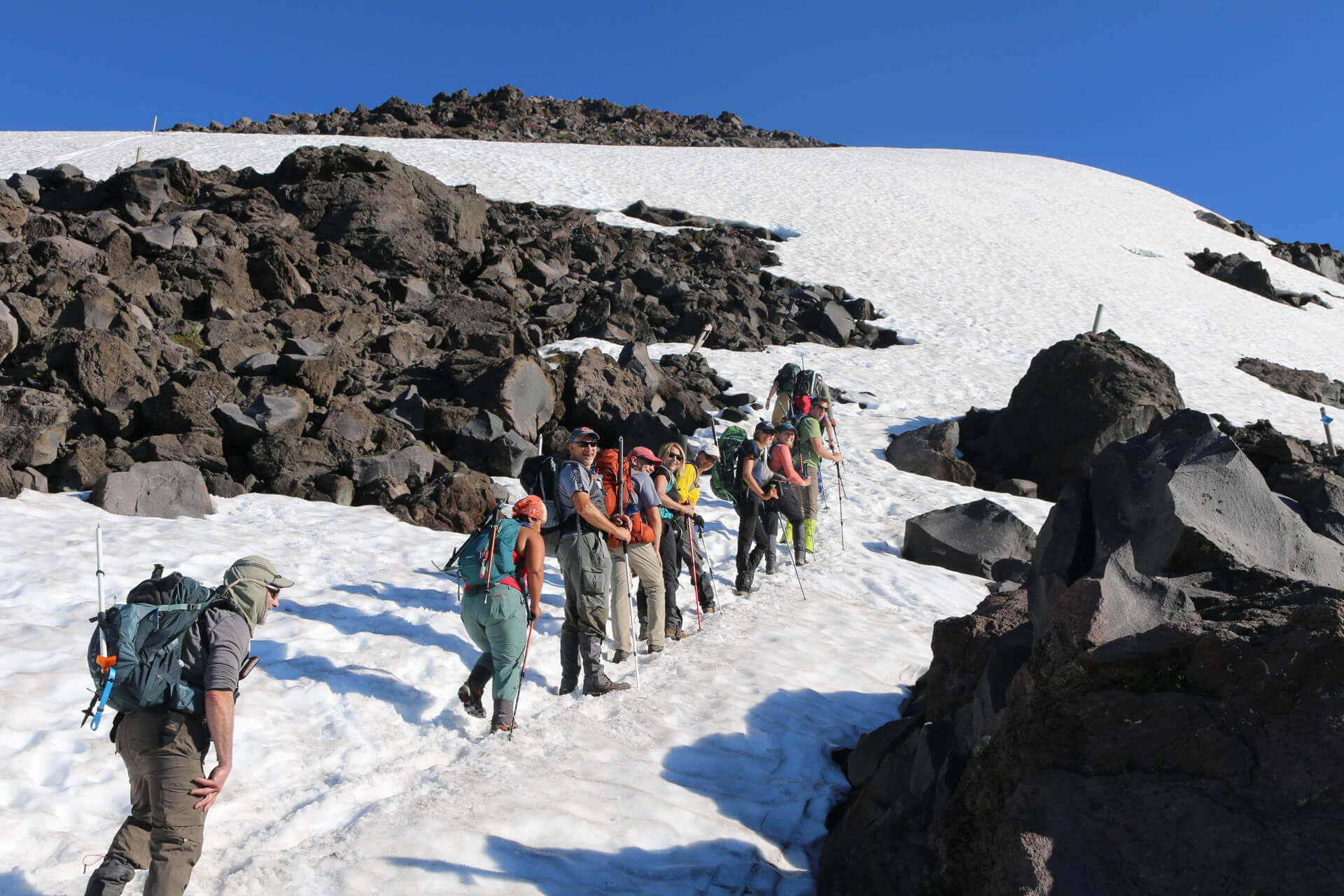
Climb Mt St Helens
Climbing to the summit of Mt St Helens and looking into the crater is one of the top three experiences of my life! I’ve done it several times and it’s absolutely incredible. It is a challenging, long, steep and exposed all day adventure that requires preparation.
Read all about how to plan your own summit climb here .

Privacy Policy
Mount St Helens Visitor Center
3029 Spirit Lake Hwy, Castle Rock, WA 98611
Summer: 9 a.m. - 4 p.m.
Winter: 9 a.m. - 4 p.m. Closed Mondays and Tuesdays.
Email: [email protected]
Phone: (360) 274-0962
Map & visitor guide
46.294580628223, -122.82193932619, additional information, group tours.
Group tours should contact the Interpretive Center early with proposed tour dates for the year. * All groups, both Educational and Non-education requesting a tour should register their visit with park staff by emailing [email protected] or calling Mount St. Helens Visitor Center at (360) 274-0962. This allows park staff to update our activity calendar and ensure all groups are provided a meaningful visit and accommodations/requests are met.
Educational group tours
Educational groups are encouraged to register in advance. To request a visit, please contact the park directly at (360) 274-0962 or complete the registration form and email to [email protected] .
Click here for the registration form (PDF, 124KB) .
Upon approval, a confirmation email will be sent. Preregistered educational groups are not subject to admission and Discover Pass fees. In order to receive the fee waiver, we request students complete an assignment during their visit. Site-specific assignments are available below, otherwise teachers are encouraged to bring their own activity. The Junior Ranger and Junior Geologist program is not intended for students, this is for paying patrons only.
Landscapes of Change Field Trip
We have partnered with the Mount St. Helens Institute to design a new opportunity for school groups, a self-guided excursion on our 0.6-mile accessible Wetland Haven Trail. Follow this link to learn more: Landscapes of Change: Free curriculum for the Washington State Parks Mount St. Helens Visitor Center .
Teachers are welcome to download the pre-trip activities, student journal pages, the facilitator activity guide and the post-trip activity. Please contact us directly if you have any questions or would like to check out supplies to support your field trip.
Educational materials
Pre-visit lesson, grades K-2 (PDF, 96KB)
Activity sheet, grades K-2 (PDF, 346KB)
Pre-visit lesson, grades 3-5 (PDF, 310KB)
Activity sheet, grades 3-5 (PDF, 223KB)
Pre-visit lesson, middle and high school (PDF, 82KB)
Activity sheet, middle school (PDF, 247KB)
Activity sheet, high school (PDF, 314KB)
Non-educational group tours
*All groups are asked to contact park staff to register their group for a visit. *All non-educational tour groups must have a valid Commercial Use Permit to visit the center. The cost is $200 per bus load, not the number of people per bus. *A Commercial Use permit waives the per person and Discover Pass fees at this location.
For additional information and to apply, visit the Commercial Use Permit webpage . Please allow up to 30 days to process your permit.
Hours of Operation
Winter season.
Nov. 1 - Mar. 24, hours of operation 9 a.m. – 4 p.m. Wednesday through Sunday. Closed Monday and Tuesday.
Spring season
Mar. 25 - May 31, hours of operation 9 a.m. - 4 p.m. Open seven days a week.
Summer season
June 1 - Oct. 31, hours of operation 9 a.m. - 5 p.m. Open seven days a week.
Observed holidays:
The center is closed for the following holidays:
- New Year's Day
- Martin Luther King Jr. Day
- Presidents' Day
- Veterans Day
- Thanksgiving Day and Friday after
- Christmas Day
Additional Area (non- Washington State Park entity) Visitor Centers
The Forest Learning Center , operated by Weyerhaeuser is located at milepost 37. For additional information, visit Weyerhaeuser’s Mount St. Helens webpage .
The Science and Learning Center , operated by the Mount St. Helens Institute, is at milepost 43. For additional information, visit The Science and Learning Center’s webpage .
The Johnston Ridge Observatory , operated by the U.S. Forest Service, is at milepost 52. For more information about their facility please visit the Mount St. Helens National Volcanic Monument site . For field trip planning, visit their Teacher's Corner page .
**Due to a landslide in May 2023, the Johnston Ridge Observatory is CLOSED until further notice.
Overnight accommodations
Connected by a short pedestrian tunnel is Seaquest State Park . Reserve a campsite, group camp or yurt to enjoy more of the area.
The park offers Wi-Fi service, in limited coverage areas. For more information, visit our Wi-Fi in the Parks page .
- Find Sno-Parks
- Find Activities
- Get Involved
- Passes & Permits
Wanderlust Travel & Photos
Seeing the world one trip at a time.
- Work With Me
- Travel Journal
- Privacy Policy
- Browse by Continent
- Thailand Travel
- Australia Travel
- Peru Travel
- Browse by Region
- East North Central
- East South Central
- Mid-Atlantic
- New England
- South Atlantic
- West North Central
- West South Central
- Central America
- North America
- South America
- Travel Vlog
- Instagram Photos
The All You Need Mount St. Helens Visitor Guide
LAST UPDATED: 2/4/24 – Mount St. Helens Visitor Guide
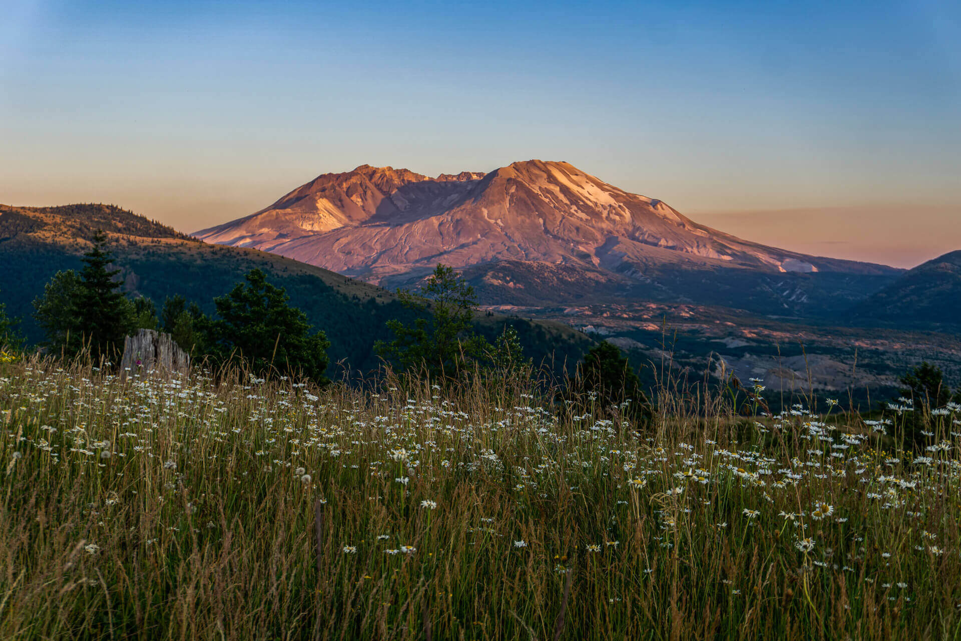
When Mount Saint Helens in Washington erupted on May 18, 1980, the eruption killed 57 people and sent volcanic ash as far as the East Coast of the United States. That eruption left a lasting impression on the mountain as it left a horseshoe-shaped crater when the eruption blasted away part of the mountain. Today, the mountain is one of the most popular tourist attractions in the Northwestern United States, drawing people from all over the world to see the mountain that once shook the United States.
Situated roughly 50 miles Northeast of Portland, Oregon, and roughly 96 miles South of Seattle, Washington as the crow flies, Mount Saint Helens is located in a beautiful part of America’s Pacific Northwest that has an abundance of tourist attractions. Visitors to the Mount Saint Helens National Volcanic Monument can learn about the 1980 eruption that left such a lasting impact on the surrounding landscape, hike in some of the most beautiful and serene landscapes, and marvel at the power of Mother Nature.

An All You Need Mount St. Helens Guide
In this Mount St. Helens visitor guide, I am going to give you all of the information that you need to plan a successful trip to Mount Saint Helens National Volcanic Monument. I am going to let you know the best ways to get there, outline the best times to plan your visit, and then give you some recommendations on where to stay when you visit. I will also give you some recommendations on where to get some of the best pictures of the mountain in the area, provide you with some recommended hiking paths, as well as provide you with some additional sightseeing ideas for your trip.
Mount St. Helens Guide Navigation Menu
How to get to mount st. helens.

Mount Saint Helens is located in the Southern part of the state of Washington in the United States, near the border with the state of Oregon. In fact, Mount Saint Helens is actually closer to the city of Portland in Oregon than it is to Seattle, Washington. To give you a general sense of where it is located, I have provided an area map for you to review in my Mount St. Helens visitor guide below.
Mount St. Helens is Close to Both Seattle and Portland
Situated between the cities of Seattle and Portland in the Pacific Northwest, Mount Saint Helens is close to many other popular tourist attractions in the area. To give you a sense of how far Mount Saint Helens is from other attractions in the area, I have included a table below that outlines some of those distances and drive times.
There are three primary ways that you can approach Mount Saint Helens National Volcanic Monument to view the mountain. From the West, visitors can stop at Johnston Ridge to get some fantastic views of the mountain from the North, as well as make a stop in the interactive visitor center to learn about the mountain’s eruptions.
In the East, visitors can stop at Windy Ridge viewpoint to get a different perspective of the mountain and hike on some of the area’s most scenic trails. Finally, in the South of the mountain viewers can hike through Lava Canyon, visit the Ape Caves, or attempt a summit of the mountain.

View Larger Map
Best Time to Visit Mount St. Helens

To assist you in determining the best time for you to plan your trip, I have included some information on average temperature, average precipitation levels, and the average number of visitors for you to review below.
Temperature (°F)
Because Mount Saint Helens is at a relatively high elevation, the weather near the mountain can be rather unpredictable. In the winter, temperatures near the mountain can be quite chilly and even fall well below freezing. In the summer, the high elevation keeps the temperatures from getting too warm. Even in the summer months, nighttime temperatures can be quite cool.
Precipitation (Inches)
If you would like to avoid freezing rain or snow, then I would recommend avoiding the winter months of November through March. This is the wettest time of year around Mount Saint Helens, with the wettest month being December. During the summer months of June through September, the area sees the lowest amount of precipitation of the year.
Average Visitors
According to Google Trends, the time of year when people are most interested in Mount Saint Helens is during the Spring months. This makes sense as the spring and summer months have the best weather. If you are looking to avoid crowds when you visit, your best bet would probably be early autumn. You should still have decent weather, but the crowds will be much thinner.
NOTE: The chart below is from Google Trends and shows the relative amount of Google searches for Mount Saint Helens by tourists throughout the year. The numbers are calculated relative to the peak month, which is mid-May. For instance, September 16th saw roughly 60% of the searches for “Mount Saint Helens” as May 13th, which was the peak day.

Where to Stay Near Mount St. Helens
Unless you are looking to camp out, there aren’t a lot of options for lodging right by Mount Saint Helens. However, there are quite a few lodging options within an hour’s drive of the monument. To assist you in locating a place to stay during your travels, I have included a list of recommended hotels at different price points in my Mount St. Helens visitor guide below.

Campgrounds Nearby
If you would like to save some extra money, there are also several quality campgrounds and RV parks in the area that you can stay at. To give you an idea of what is available, I have included a list of recommendations below for you to review.
- Cougar RV Park & Campground
- Beaver Bay Campground
- Merrill Lake Campground
- Kalama Horse Camp Campground
- Quartz Creek Big Trees Campground
- Iron Creek Campground
- Tower Rock U-Fish RV Park
- Blue Lake Creek Campground
- Campground: Olallie Lake
Hiking Near Mount Saint Helens

Another thing that Mount Saint Helens National Volcanic Monument has in abundance is great hiking trails. There are a number of great trails in both the East, West, and South of the national monument. If you are looking for a good hiking trail in the area, I have outlined a half dozen trails that I recommend below.
Popular Mount St. Helens Tours

If you are looking to add some extra adventure to your trip, several really great tours are available in the Mount Saint Helens area. I have included a list of the highest-rated tours and activities below for you to review should you want to book something for your trip.
The Ape Caves

If you are on the south side of the mountain, one of the most unique features that you can tour is the Ape Caves. These lava tunnels are surreal and absolutely worthwhile to tour if you have the time. There is no better way to get a first-hand look at how this volcano works than exploring the mountain’s lava tunnels.
Where to Photograph Mount St. Helens

View Larger Image
There are some absolutely fantastic pictures that you can get on the West side of the mountain. Not only does the Johnston Ridge viewpoint have some good spots to take photos, but you can get some really good shots of the area where the eruption blast devastated as well.

If you are up for doing some hiking then the East side of the mountain is my favorite side for getting shots. The path takes you into the valley right in front of the mountain and you can get some absolutely gorgeous shots of Mount Saint Helens.
PRO TIP : Doing research on a location is one of the best things you can do to increase the quality of your travel photographs. For some tips on how to do some pre-trip scouting for photo opportunities, check out my article on The Art of Travel Photography – Planning Your Shots. In this article, I review the process that I use to do pre-trip photography planning to give you photography location tips like the ones you see above.
Other Things to See in the Area

Because of its location, it is really easy to combine a visit to Mount Saint Helens with stops at some of the other popular tourist spots in the Northwest United States. If you are looking for some additional places to add to your itinerary, I have included a list of the other top tourist spots in the area below.

Mount St. Helens Photo Gallery
Mount Saint Helens is a beautiful mountain in a beautiful landscape. It is almost impossible not to take beautiful pictures when visiting. Below is a gallery of just some of the pictures I was able to take during my visit.
If you would like to see more of my travel photography, I would also encourage you to give me a follow on Instagram . Putting this blog together to pass on my free guides, itineraries, and travel photography tips is a lot of work and your support in the form of a follow-on Instagram would be so very much appreciated!

Don’t Forget to Subscribe to My Adventures!
Type your email…

Let Me Help You Save On Your Next Adventure!
‘start exploring today’ merchandise available now.
Published by Josh Hewitt
Avid traveler and photographer who loves to see new places, meet new people, and experience new things. There is so much this world can teach us, we just need to explore! View all posts by Josh Hewitt
Related Articles

Brazil Entrance Requirements: What to Know Before Traveling

Plan Your Perfect Trip with this Zaragoza, Spain Travel Guide
The Ultimate Gibraltar Travel Guide: Everything You Need to Know
20 comments ›.
I love all the information you provide! Thanks so much!
Thank you so much for the kind words, and for reading! 😀
Visiting Mount Saint Helens is on my list to do this summer, since we are so close (Seattle area)!
You are close! Seattle is such a beautiful city. I love the Northwest 😀👍
There is no shortage of activities to get into up here, that’s for sure.
Indeed! Olympic NP is my favorite.
Put this on my bucket list!
You will love it!! 😀
There is so much to see and do in the Pacific NW. I have to get back there. Excellent post!
Thank you so much!!! It is one of my favorite areas. So beautiful.
I totally agree with you on researching before visiting tour sites. Asides helping you find good camera angles, you could earn a lot of knowledge regarding the place and not appear so much as a “newbie”
Exactly!!! Thanks so much for reading!! 😀👍
This is fantastic. We did the helicopter tour when I was a teenager, and it was so incredible that I still remember it now, 25 years after the fact.
Thanks Scott!! I really appreciate it! The helicopter ride must have been amazing!!
It was! It was worth whatever my parents paid for it, that’s for certain!
Another great post! I made the mistake of visiting Ape Caves during a snowy November when there weren’t many people around the park. I checked it out by myself with a pretty weak flashlight and felt the darkness surround me. It was very eerie, but an excellent trip nonetheless!
Thank you for the kind words! That would be so spooky to visit during the winter.
What an awesome Mount St. Helens visitor guide! I just blogged today about our trip (last fall) to the East side of the park. I somehow missed this post of yours until today, but it’s so good that I just added a link to it in my post. Also, after reading your guide I know that I must see the south and west sides of the park one day as well!
Awesome!! I am definitely going to check out your post! I appreciate the kind words 😀👍
Leave a Reply Cancel reply
Thank you so much for the kind words!! 😊
Very good! What photography, no words to say anything
You will be fine! I just looked at your camera and I don’t think you’ll have any issues at all.…
Hello. We arrive in Lima May 12. I just heard there is a limit of 200mm for a lens in…
Discover more from Wanderlust Travel & Photos
Subscribe now to keep reading and get access to the full archive.
Continue reading
Subscribe To My Adventures!

Home » Mount St. Helens Guide: Things to do & More
Mount St. Helens Guide: Things to do & More
Climb a volcano, take a hike, explore a cave system, and so much more.
Known for its eruption in 1980, which spewed massive clouds of ash, today Mount St. Helens National Volcanic Monument beckons visitors with a combination of history and stellar outdoor recreation.
Climb to the crater rim, hike subterranean lava tubes, kayak in clear mountain lakes, shred blast-zone mountain bike trails or take a guided hike with a geologist. Best of all, Mount St. Helens offers all-season recreation. While summer draws the most crowds, the other three seasons offer plentiful opportunities for hiking, paddling, fishing, snowshoeing, snowmobiling, and cross-country skiing. Read on for how to make the most of your visit.
Getting to Mount St. Helens
Mount St. Helens is located in southwest Washington east of Interstate 5. The main entrance on the west side of the mountain is on State Route 504, which leads to the Science and Learning Center at Coldwater (open daily in the summer and weekends in the winter) and the Johnston Ridge Observatory (currently closed).
Important Closure Notice: State Route 504 is currently closed past the Science and Learning Center at Coldwater (milepost 45.2) due to a landslide. The Johnston Ridge Observatory, a popular visitor center at the end of highway, will remain closed through 2026. Check the Forest Service page for updates.
Although the end of the highway is closed, the drive along State Route 504 offers scenic viewpoints like Castle Lake and Loowit, as well as access to Coldwater Lake .
Other access points can be found in the south and east. Driving to Cougar, the southern gateway, takes about 3.5-4.5 hours from Seattle and an hour from Portland. On the east and south sides of the monument, a National Forest Recreation Pass ($5 day per vehicle, $30 annual) is required. You can pick one up at self-service pay stations and Forest Service offices.
When to Visit Mount St. Helens
Summer is the busiest season, often drawing significant crowds. Amanda Bonney, a Mount St. Helens visitor services assistant, recommends visiting mid-week and arriving early in the morning to secure parking.
“Crowds are thinner the first and last week of summer break,” Bonney notes. In the fall, crowds thin out, leaving visitors to enjoy autumn colors, milder weather, and fewer insects. There are also stellar, low-crowd days in spring, but be prepared to run into snow.
Travel Tip: Be sure to secure reservations for popular areas. Both the Lewis River Recreation Area and the Ape Caves trail have implemented reservation systems with a fee of $2 per vehicle. Timed reservations are always required to visit Ape Cave during the open season, from May through October. For Lewis River , reservations are required June through September.
Things to Do at Mount St. Helens
Take a hike.
For hikers, the Mount St. Helens area has a little of everything, from lava tubes to waterfalls. Far above ground is Coldwater Peak. The trail to the summit (12 miles roundtrip, 3,100 feet elevation gain) provides scenic mountain views. A landslide currently prevents hikers from starting at the Johnston Ridge Observatory, but the trail can still be accessed from South Coldwater Trailhead (adding a couple of miles).
Choose from a number of short, accessible trails such as the Birth of a Lake Interpretive Trail and the Johnston Ridge Eruption Trail (currently closed due to a landslide), or head hit the Lewis River Falls trail , an 8.8-mile relatively flat tour de force of waterfalls. To circumnavigate Mount St. Helens and tour much of its varied terrain, advanced backpackers can take on the 32-mile Loowit Trail .
Visit Ape Caves
Due south of the mountain, the Ape Caves trail (2.8 miles, 350 feet of elevation gain) navigates the third-largest lava tube in North America. Hiking through the Upper Cave requires some dexterity, fitness, and willingness to scramble and duck among the fascinating features of the cavern. After 1.4 miles, hikers exit the cave and loop back on a trail. Alternatively, an easier shorter option (1.5 miles round trip) is the Lower Cave, which is more spacious and less technical.
Travel Tip: Open May through October, the Ape Caves trail requires a reservation to limit foot traffic and protect the delicate subterranean environment.
Climb the Mountain
Mount St. Helensis one of the easiest volcano climbs in Washington thanks to limited avalanche danger and crevasse exposure and attracts both beginning and experienced mountaineers. Although it’s climbable year-round, late spring through early fall is the most popular time. Most climbers use the Monitor Ridge Route from Climbers Bivouac. The non-technical nature of this route, which takes between seven and 13 hours, lends itself to beginners. However, climbers need to scramble up steep sections and be fit enough to climb 4,500 feet in five miles to the crater rim at 8,365 feet elevation.
Travel Tip: Climbing permits are always required. For climbers who want support, the Mount St. Helens Institute guides trips to the summit.
Go Mountain Biking
Intermediate and advanced riders can enjoy a number of iconic and popular mountain bike trails in the area. Mostly singletrack, the Ape Canyon to Plains of Abraham out-and-back ride (21 miles, 2,700 feet of elevation gain) entails a long, steady climb out of the heavily forested Ape Canyon to the moonscape of the blast zone, which becomes rife with wildflowers in the spring.
Southeast of Mount St. Helens, the forested Lewis River Trail (28 miles, 2,700 feet of elevation gain) skirts a river over rolling banks and chunky technical sections. For a guided trip, Trans Cascadia Excursions leads one-day rides on Strawberry Mountain through the blast zone.
Also See: Explore Washington’s Epic Mountain Biking Trails
Visit a Viewpoint
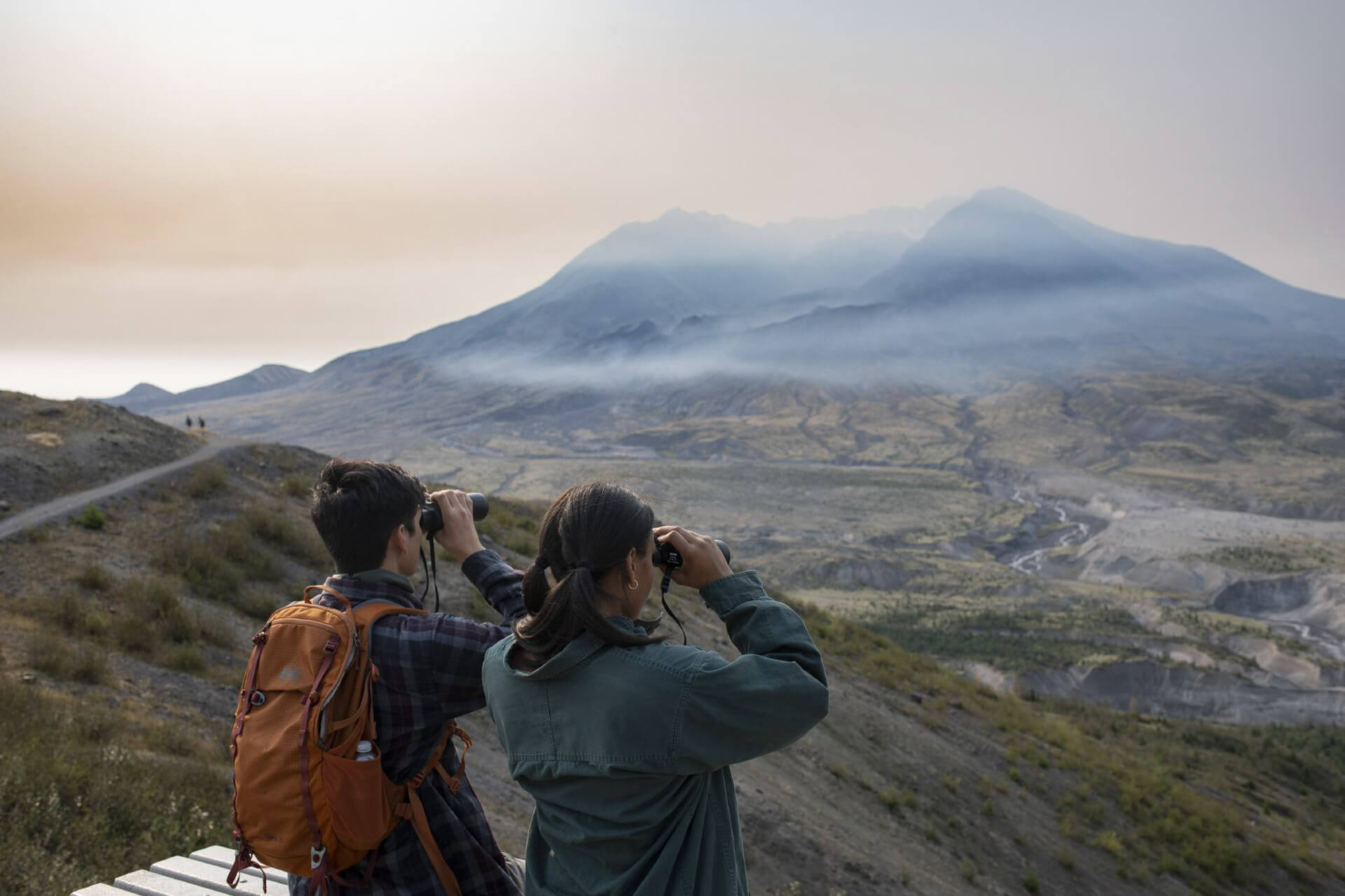
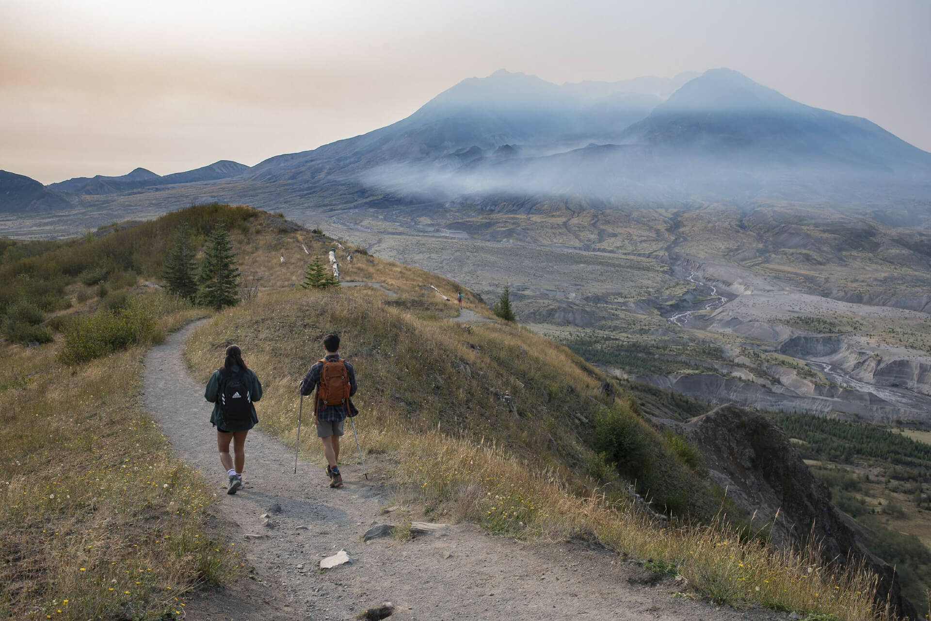
Within the Mount St. Helens National Volcanic Monument, there are a number of spectacular viewpoints that don’t require hiking. Although currently closed due to a landslide, the Johnston Ridge Observatory is situated in the heart of the blast zone and enjoys expansive views of the volcano and crater. A mile from the observatory, Loowit Viewpoint has vistas across plains of pumice to the lava dome inside the crater.
Five miles north of Mount St. Helens, climb a 368-step sand ladder for magnificent views at the Windy Ridge Interpretive Site , which not only has close-up crater views, but also a panorama of Spirit Lake and now-greening pumice fields left in the wake of the eruption.
Learn Something New
In 1996, the Mount St. Helens Institute (hosted at the Science and Learning Center at Coldwater ) opened its doors with the goal of deepening the public’s understanding of the Pacific Northwest’s most active volcano. The institute hosts ecology programs for kids, family camps, and guided daylong or multi-day adventures , from mushroom hunting and photography hikes to snowshoeing and eruption walks with geologists. Drop into other learning centers along the Spirit Lake Memorial Highway – including the Mount St. Helens Visitors Center , the Forest Learning Center , and Johnston Ridge Observatory (currently closed due to a landslide).
The lakes and rivers around Mount St. Helens are hallowed destinations for anglers. Just south of Mount St. Helens, Merrill Lake is a haven for fly fishing; this catch-and-release-only lake is heralded for its abundant trout. Spring through fall, the Lewis River is known for its robust salmon and steelhead runs. The river is dammed at three different points – Yale Lake, Swift Reservoir, and Lake Merwin – where anglers can catch kokanee, tiger muskies, and rainbow trout. Columbia River Fishing Guides lead salmon and steelhead expeditions on the Lewis River.
Enjoy Kayaking and Paddleboarding
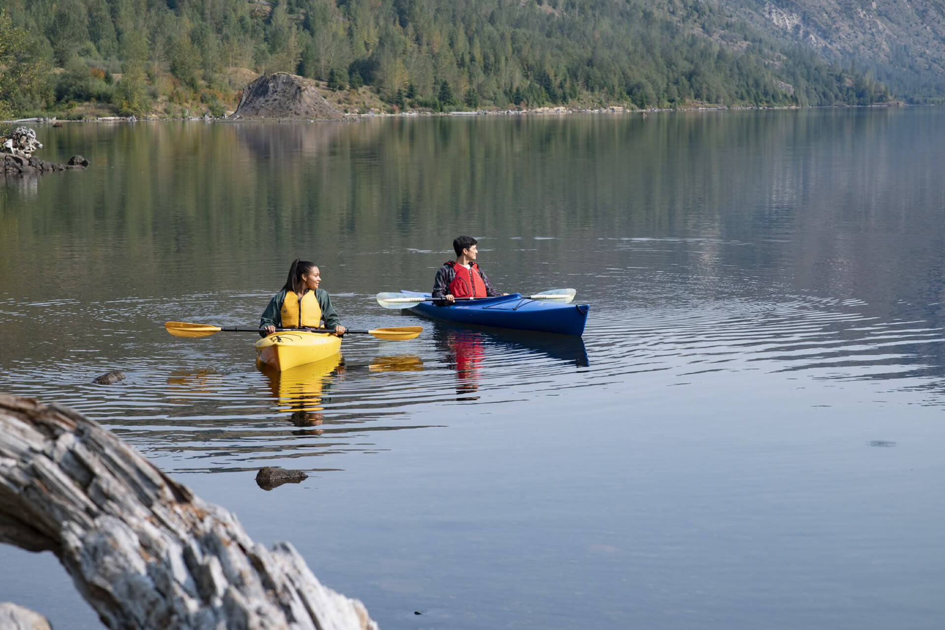
Mountain lakes with easy launching options make for lovely kayaking and paddleboarding. With no motorized boats allowed, clear Coldwater Lake provides a serene paddle surrounded by forest and mountains. For those who want to hit the water but don’t have the gear, head to Silver Lake Resort where they rent canoes and kayaks as well as pedal boats and pontoons.
Enjoy Winter Recreation
When snow blankets the slopes of Mount St. Helens, the party is just getting started. At the Marble Mountain SnoPark , cross-country skiers and snowshoers will find around 36 miles of trails (some groomed) and snowmobilers have access to 25 groomed miles. The June Lake trail provides a mellow and incredibly scenic out-and-back snowshoe option (5 miles, 500 feet of elevation gain). Cougar SnoPark caters primarily to snowmobilers and features 25 miles of trail.
Travel Tip: SnoPark permits are required, and it’s advised to check the avalanche report before heading out. Call Mount St. Helens at 360-499-7800 for grooming status updates.
Where to Stay near Mount St. Helens
While there is no camping within the monument boundaries, there are several camping options surrounding the monument. Seaquest State Park near Silver Lake boasts a pedestrian tunnel that connects to the Mount St. Helens Visitor Center and the shoreline interpretive trail. In Gifford Pinchot National Forest, the Lower Falls Campground on the Lewis River operates May through October, while northeast of the mountain you’ll find Tower Rock Campground .
Hotels and Resorts
Along the Interstate 5 corridor to the west, visitors can find a slew of traditional hotel options. About midway between the northern and southern Mount St. Helens access roads off Interstate 5, the Kalama Harbor Lodge , a river-view McMenamins property, has uniquely decorated guest rooms showcasing the local history and characters of Kalama.
In Cougar on Yale Lake, the Lone Fir Resort caters to the outdoor set, renting mountaineering gear and offering cozy cabin accommodations along with tent sites. Along the Spirit Lake Memorial Highway to the north, Eco Park Resort is an 80-acre forested property that has 12 miles of private trails. Mostly powered by solar and propane, the resort has a cafe on site, and visitors can stay in cabins or camp out. Further west, Silver Lake Resort is open year-round and is all about fishing and lake life.
Mount St. Helens FAQ
What are the entrance fees and operating hours?
On the east and south sides of the monument, a National Forest Recreation Pass ($5 day per vehicle, $30 annual) is required. Self-service pay stations and Forest Service offices sell the passes. On the west side, a Monument Pass ($8 per adult, 15 and younger free) is required at the Johnston Ridge Observatory and adjacent trailheads; purchase them at the observatory. America the Beautiful passes also work. The Mount St. Helens Visitor Center at Silver Lake is open from 9 a.m. to 5 p.m. in the summer and 9 a.m. to 4 p.m. in the winter (closed Mondays and Tuesdays).
When did Mount St. Helens erupt?
On May 18, 1980, a magnitude 5.1 earthquake triggered one of the world’s largest recorded landslides leading to the eruption of Mount St. Helens. The eruption was one of the most powerful volcanic blasts in American history. In its wake, scientists and visitors alike have been given the opportunity to witness biodiversity slowly reclaim an area of catastrophic devastation. In 1982, President Ronald Reagan set aside 110,000 acres around the volcano, creating the Mount St. Helens National Monument.
Is Mount St. Helens pet-friendly?
Because of the delicate nature of the ecology within Mount St. Helens National Monument, pets are prohibited in certain areas (see the Forest Service map ). Pets are allowed on paved roads, campgrounds, and picnic areas, and are required to be on leash at all times.
Can you climb to the top of Mount St. Helens? Do you need a permit?
Yes and yes. Most climbers use the Monitor Ridge Route from Climbers Bivouac, a non-technical route that requires less gear. A permit is always required.
About the Author
Ellee Thalheimer is a freelance writer and guidebook author based in the Pacific Northwest who has contributed to publications like Lonely Planet Guidebooks, Alaska Airlines Magazine , and Adventure Cyclist Magazine . When she can’t get outside, she writes fiction, drinks local IPAs, and perfects her handstands.
Discover Washington’s Water Trails
From estuaries teeming with wildlife to cliff-bound rivers, explore the state’s official water trails.
Taps + Trails: Washington Hike and Brewery Pairings
Cheers to the epic combination of gorgeous Washington hikes and craft breweries.
Guide to Whale Watching in Washington
From the Olympic Coast to the Salish Sea, here are some of the best places to spot whales.
Sponsored Content
- About Trudy

Live & Travel Well for a Healing Journey...
Mt. st. helens scenic daytrip itinerary in washington state.

The volcanic eruption of Mt St Helens in 1980 became the most devastating in U.S. history. A Mt St Helens daytrip inspires, with the power and renewal of nature. Getting the most out of a daytrip requires planning, as Mt St Helens Volcanic National Monument is massive with 3 main sections: West, South and East. For most visitors the west section is the best for first timers. Here, I explain why and what to do if you only have one day at Mt St Helens National Monument.
Mt St Helens is located in southwest Washington and part of the Cascade Volcanic Arc, a section of the Pacific Ring of Fire. It lies just 50 miles south of Mount Rainier and 33 miles west of Mount Adams. Its eruption on May 18, 1980 is one of the largest volcanic explosions in the history of North America. The active stratovolcano stands at 8,366 feet high, with its crater blown out of the north face.
Mount St Helens Daytrip at West Side

Directions: Take State Route 504 eastward 52 miles from Castle Rock on Interstate 5. The main highlights of the west side are along Highway 504. The Johnston Ridge Observatory is at the end of the 504 about an hour’s drive from Castle Rock.
Overall, the west side is the heart of the blast zone with these main sites: Mt St Helens Visitors Center, Johnston Ridge Observatory, Eruption Trail, Harry’s Ridge Trail, Coldwater Lake and Trail and Hummocks Trail.
Mt St Helens Visitors Center
Mt St Helens Visitors Center is about 30 miles from the volcano and an introduction to its history and significance. Located on the Spirit Lake Highway it offers learning opportunities, such as, theatre showing the eruption, chronological timeline on events leading up to the eruption, displays and current seismographs of the mountain. Also, the visitors center is located near Silver Lake with a .6-mile walking trail to learn about the flora and fauna of this ecosystem.
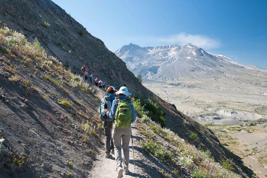
Johnston Ridge Observatory, Eruption Trail and Harry’s Ridge Trail

If you haven’t seen Mount St. Helen’s before, the Johnston Ridge Observatory is the ideal place to start exploring. Perched on the Johnston Ridge in the heart of the blast zone, it looks southward at the crater, lava dome, pumice plain and landslide across the valley. Named after the volcanologist, David A. Johnston, who lost his life in the eruption, the Observatory offers ways to experience and learn about this amazing volcano with stunning views. Also, there’s an outdoor theatre for presentations facing the volcano.
Near the Observatory is the .8 mile Eruption Trail on a hill, overlooking the volcano. It offers explicit displays and placard explaining the timeline and events leading up to the eruption. This is a great opportunity to let it all sink in and learn all while looking at the smoldering volcano.

Eruption Trail leads to the longer Harry’s Ridge Trail as the best way to observe the volcano. It’s named after the curmudgeon, Harry Truman, who wouldn’t leave his home and died in the eruption. Harry’s Ridge is a 9-mile up and back moderate trail that continuously views Mt St Helens’ crater. Additionally, this trail displays the colorful wildflowers of the area in summer months. It goes to the beautiful spot overlooking Spirit Lake with breathtaking views of this cobalt blue body of water below the ridge. This trail is reasonably wide and well-maintained, however, there are times it gets very close to the steep edge. So, if you have a fear of heights this trail may be a challenge.
Coldwater Lake

This pristine blue-green lake is a wonderful place to swim and cool off on a hot day. The eruption created this lake from its landslide damning the Coldwater Creek. Furthermore, its Birth of a Lake Trail has interpretive signs, that describe how the lake became created. There are also picnic tables and restrooms. Visitors enjoy this lake by swimming, fishing, hiking and paddle boarding.
Hummocks Trail
Across the road from the Coldwater Lake is the Hummocks Trail. This 2.3-mile loop takes you through hummocks (small hills) that were pieces of the mountain carried down by the landslide during the eruption. Walking through the labyrinth of these small hills overgrown with shrubs and small trees is another opportunity to experience parts of the mountain. Additionally, this welcomes some shade on a hot day.
Overall, Mt St Helens Daytrip
There is nothing like a day here to observe the powers of Mother Nature. The renewal of the region is awe-inspiring, reminding us that everything in life has its cycles and seasons for birth, death and renewal.
Read More! Ultimate Guide to Mt Rainier National Park: All You to Need to Know 20 Amazing Must-Do Hiking Trails in Washington State

Leave a Comment Cancel Reply
Save my name, email, and website in this browser for the next time I comment.

Adventures in Destinations Unknown

Day Trip to Mount St Helens National Monument
Last modified on October 1st, 2020 at 10:05
Four decades ago, Mount St Helens unleashed the most destructive eruption in modern US history. The volcano’s explosion expelled 520 million tons of ash that darkened the skies above Washington State. The plumes of smoke traveled eastward nearly 2,000 miles across the country—leaving a blanket of ash in their wake.
The eruption of Mount St Helens created the largest debris avalanche in recorded history. It killed 57 people in its path, and wiped away much of the mountain’s northern face.
Today—forty years after the explosion forever changed the appearance of one of Washington State’s most iconic peaks—the national monument is a beloved Pacific Northwest attraction. It makes for a fantastic weekend getaway, and is a popular day trip destination for travelers from Portland and Seattle.
Table of Contents
MOUNT ST HELENS DAY TRIP FROM SEATTLE OR PORTLAND
Mount St Helens National Monument lies approximately three hours southeast of Seattle and an hour and a half northeast of Portland. Its central location between the Pacific Northwest’s two largest cities, makes it a popular day trip from both Portland and Seattle.
Though Mount St Helens is certainly an ambitious place to visit in one day (especially if coming from Seattle) it is still worth exploring for those with limited time. The area offers a plethora of hiking trails, viewpoints, and educational resources for kids.

When Dan and I chose to take a day trip from Seattle to Mount St Helens, we knew we would have to prioritize certain aspects of our visit. We researched the best hiking trails in Mount St Helens and mapped out the monument’s most scenic viewpoints.
In the end, our day trip to Mount St Helens consisted of a stop by the Johnston Ridge Observatory, and a breathtaking hike along Harry’s Ridge Trail.
JOHNSTON RIDGE OBSERVATORY
The Johnston Ridge Observatory was named for a volcanologist who lost his life during the Mount St Helens eruption. He was one of the 57 people who perished that day.
The observatory lies at the terminus of State Highway 504, in the heart of the volcano’s blast zone. Its viewing platform provides up-close access to the park’s geology. The viewpoint is wheelchair accessible and offers a direct look into the crater.
Access to the area requires an $8 per person Monument Pass.

The visitor’s center at the Johnston Ridge Observatory hosts interpretive displays that tell the story of Mount St. Helens and its eruption. The center’s interactive exhibits allow visitors to learn more about the area’s unique geology and history.
HARRY’S RIDGE TRAIL
Like the Johnston Ridge Observatory, Harry’s Ridge Trail was named after a victim of the volcano’s eruption. Even prior to his death, the victim—Harry R Truman—was a bit of a local legend. A prohibition bootlegger, petty criminal and collector of cats, he was a man who lived by his own rules. In the weeks leading up to the explosion, scientists and researcher were unsuccessful in convincing Truman to evacuate the area. Despite dire signs of an imminent eruption, Truman refused to leave his home at the edge of Spirit Lake. “If the mountain goes. I’m going with it,” he’d stated.
And on that fateful day in 1980, Harry became true to his word. He and his sixteen cats perished in the onslaught.

Harry’s Ridge Trail is one of the most popular hikes in Mount St Helens. It begins at the Johnston Ridge Observatory and extends just over four miles in each direction. For travelers visiting the mountain as a day trip, it is a comprehensive hike that features many of the national monument’s most scenic views. Revealing birds-eye panoramas of the park’s altered landscape, Harry’s Ridge Trail showcases the splendor—and legacy— of the mountain that Harry Truman so dearly loved.
The 8.5 mile out and back trail follows a ridge line and rises at a gradual incline. It is well-maintained and doesn’t require any technical hiking skills.
Throughout the duration of the hike, the trail gives way to intimate views of the Mount St Helens crater and mudflow, before turning inward and climbing gradually up the back side of Harry’s Ridge.

The end of Harry’s Ridge Trail rewards hikers with commanding views of Spirit Lake.
Beyond, its spectacular panoramic vista highlights Mount Adams to the east, Mount St Helens to the south, and Coldwater Peak to the north.
Spirit Lake is the main body of water visible from the end of Harry’s Ridge Trail. The lake has an interesting history, as it has been shaped and altered by volcanic activity for its entire existence.
The lake originally formed when rock fragments dammed two creeks in the area. But then, in 1980, a debris avalanche from the Mount St Helens eruption temporarily displaced much of the lake from its bed. Spirit Lake’s surface area increased in size after the displacement, spreading out its waters to cover an additional 2,000 acres.
The blast deposited thousands of pyrolized trees into Spirit Lake. These shattered trees formed a floating log raft on the lake’s surface. Four decades after the event, the log raft still floats around the northern reaches of the lake.
HIKING MOUNT ST HELENS
Mount St. Helens is a popular climbing destination for both beginning and experienced mountaineers. All routes to the top of Mount St Helens include sections of steep, rugged terrain.

Though climbing Mount St Helens does not require technical skills, hikers must obtain a permit from Recreation.gov. Permits are mandatory year-round for anyone who desires to climb above an altitude of 4,800 ft.
I did not include a hike up Mount St Helens in my day trip itinerary due to limited time and lack of advanced planning, but I hope to summit its cratered peak at some point in the future.
Ape Cave is the longest lava tube in the United States and a popular Mount St Helens attraction. Similar to the Lava River Cave in Central Oregon’s Newberry Crater , Washington’s Ape Cave is a subterranean passageway formed by molten lava.
Ape Cave lies at the opposite edge of the national monument from the Johnston Ridge Observatory. Since roads do not connect the two destinations, it can be difficult to include Ape Cave into a Mount St Helens day trip itinerary.
Travelers interested in visiting the Ape Cave Lava Tube are better off touring the attraction as part of a separate trip, or as part of a multi-day Mount St Helens visit.
Mount Saint Helens National Volcanic Monument is one of the most geologically fascinating destinations in the Pacific Northwest. The mountain is a living laboratory and an enduring reminder of nature’s power.
Mount St Helens lies in the Cascade Mountain Range, between Mount Rainier and Oregon’s Mount Hood. It is one of three national monuments in Washington State —along with Hanford Reach and the San Juan Islands,
Visiting the national monument as a day trip or weekend trip is a fantastic escape into one of Washington State’s premier attractions. It is an educational outing that provides insight into the geological forces at play in this active and ever-changing corner of the Pacific Northwest.
__________________________________
Did You Enjoy this Mount St Helens Day Trip Itinerary? Pin It!

The First-Timer's Guide to Exploring Mount St. Helens
Situated in the Gifford Pinchot National Forest, Mount St. Helens National Volcanic Monument occupies a strange space for official classifications. Unlike Mount Rainier to the north, the U.S. Forest Service oversees what would be considered as the Mt St Helens National Park. But it isn't actually a state or national park, even though it's treated like one.
Although Washington state hosts the Mount St. Helens Visitor Center at Silver Lake, some famous attractions like the Johnston Ridge Observatory are run by the feds. In contrast, others associated bodies like the monument's Science and Learning Center and the Mount St. Helens Institute are extensions of nonprofit institutions.
But you're not here to read about tedious outdoor bureaucracy! You're here because you want to get better acquainted with backcountry pumice plains and lava canyons. We're here to help you with just that. Whether you're planning a day trip from big cities like Portland and Seattle or plotting a round trip from some other corner of North America, we hope the following guide gets you to the lava flows faster!
Mt. St. Helens Entrance Fee
All U.S. Forest Service areas require a $ 5-day pass for entrance and parking. Those that grant access to Mt. St. Helens also work in all other Oregon and Washington national forests for 24 hours. If you plan on dipping into national forests often, you might consider purchasing an annual recreation pass for $30.
Things to Do at Mount St. Helens

thinair28 via Getty Images
There are many things to do at Mt. St. Helens, from the usual suspects like hiking and boating to more niche activities such as paragliding and metal detecting. The best way to explore the region is in sections. There are several independent routes in and out of the monument, leading visitors to one of its distinct ecosystems. The Forest Service divides the memorial up in the following way, and their website is the best place to get more information :
This is the most accessible area to reach if you take the Spirit Lake Highway (504) from Castle Rock, WA, and the I-5. Here you'll find the Johnston Ridge Observatory and the Science and Learning Center, making it a great destination if you're interested in first-time interpretive experiences. The west side of the park has quite a few hiking trails and mountain biking routes, and Coldwater Lake is a great place for picnicking and aquatic recreation.
The monument's east side grants visitors access to Spirit Lake, the largest body of water on the mountain. This side of St. Helens also offers horseback riding and camping opportunities; the west side doesn't.

fishysam via Getty Images
Here, hikers will find some of the monument's most popular trailheads like the Ape Cave lava tube and the Climber's Bivouac trail. If you're coming up from Oregon, this side of the mountain is the easiest to reach.
Related Content
Experience "larch madness" by taking on these gorgeous washington hikes, map your adventure of mt. rainier national park, 5 family-friendly day trips to escape seattle.
If you're headed to the Norway Pass Trailhead, this side of the mountain is where you want to be. It also has some of the most amazing views the monument has to offer. Similarly, the mountain's northern slope has seen less volcanic damage and is lush with flora and fauna.
Eruption of Mount St. Helens

kwiktor via Getty Images
The good news is that Mt. St. Helens has only erupted a couple times in the last half-century. According to the USGS , the bad news is those future eruptions are both expected and predicted to be more devastating than the previous two.
But never fear! Folks brave the blast zone daily, and the mountain sends out plenty of signals before blowing its top. Just so, you don't have to worry about it exploding under your feet once you get there.
What's your favorite thing to do on Mt. St. Helens? Give first-timers a lead on our Wide Open Roads Facebook !
READ MORE: Experience "Larch Madness" by Taking on These Gorgeous Washington Hikes
You might also like.

Summit the Highest Point East of the Mississippi at Mount Mitchell State Park

Trip Planning
Explore grand teton national park, from jenny lake to jackson hole.

Rocky Mountain National Park: A Traveler's Guide to Taking Your Kids

Exploration
Lassen volcanic national park is california's best kept secret.
- Fit For Trips
- Adventure Travel
- Backpacking
Almost Everything You Need to Know about Hiking Mt St. Helens

With 17,000 miles of hiking and backpacking under his belt, wilderness guide and ultra-light backpacker Erik Soltan of Get Out Backpacking joined the Fit For Trips team to speak about hiking Mount St. Helens. He dove right into to tell us what he loves about it and provides insight on almost everything you need to know about summiting and hiking around Mt St. Helens.
This volcanic peak, located in southern Washington state in the Cascade Range, is a hiker’s playground. It is home to trails of varying distances, making it a destination for everyone from visiting families, to day hikers, to backcountry enthusiasts. Visitors can enjoy the lush greenery typical to the Pacific Northwest, grand views of neighboring Cascade peaks, and the stripped landscape of the blast zone from the 1980 eruption.
If you do plan to head to Mount St. Helens for an epic hiking trip, know that the terrain can be tough on the body, so some training can help get you ready to tackle the trails. Check out Fit For Trips’ custom training programs or schedule a complimentary fitness consultation with Marcus Shapiro.
What are the Cascades?
The Cascade Range is part of the Ring of Fire. The Ring of Fire rims around the Pacific Ocean. So, Cascade Range stretches from northern California, through the Pacific Northwest, and up into Canada’s British Columbia.
Within the Cascade Range are the High Cascades, or the volcanic peaks. Mount Baker is the furthest north, and the furthest south is Mount Lassen in Northern California.
Of course, you have peaks and wilderness areas in between these volcanic mountains, such as the Dark Divide, the largest roadless area in western Washington, and Mt. Rainier, plus some of the other areas north of Mount St. Helens that are nice to explore.
What do you love about hiking Mt St. Helens?
The diversity you see there is just unbelievable between the old growth forests and the blast zone, which has very few trees left on it. Despite this, things are growing. To see the mountain coming back, it’s what I imagine hiking in the desert would look like. If you’re one of those people that likes to see the bleak beauty of things, with wildflowers coming up through the sand or pumice, it can be really inspiring.
Hiking along Mount St. Helens you see the bits of purple and red from the Indian Paintbrush, lots of mountain goats, and all the fresh springs have little bits of moss and green in them because it’s the northwest and it gets a lot of precipitation. The colors are outrageous against the background of a landscape where everything has been stripped away.
I’ve hiked all around High Cascades with trails, and I feel like Mount St. Helens has more of a fiery history. You’ll see evidence of eruptions throughout time, not just from the 80s eruption, on all the sides of the mountains. As the mountain rebuilds it’s amazing to see the freshness of life coming back.
It’s interesting that a lot of animals like pika and marmot have such a history on this mountain. Obviously, the animals living there today haven’t lived through an eruption, but in 1980 a lot of animals sensed something coming and went underground when the landslides came through after the eruption. When it cooled down, a lot of those animals popped back out, which is also very interesting to think that, instinctively, in that area, they knew that something was going on.
Also interesting; in the 70s, the people of the Klickitat tribe were telling local scientists that there was a problem with the mountain. They noticed the northern face of the mountain was slumping and interpreted it to be upset and angry. In nearby Spirit Lake, ripples in the lake were noticable despite the absence of wind. In hindsight, it turns out the ripples were caused by earthquakes and underground volcanic activity.
The Klickitat had moved their tribe around different parts of Mt St. Helens based on where they could find food, stuff to trade with other tribes, and because of the unpredictable volcanic activity. There are Klickitat legends to keep other tribes and people away from the northern side of the mountain because of its fiery past.
What is your favorite Mount St. Helens Hike?
I’ve hiked all the ’round-the-mountain trails in the Cascades and each one is special to me. I do love the Loowit Trail going around Mount St. Helens. I’ll go into more detail about the Loowit Trail later, but my reason for loving it is for all the diversity; the landscape variety, the flora, and the animals you see along the way. It’s wild.
I hike because I get what I call “exposure” from it. The longer I’m out in those more isolated areas, the more I come back feeling like a clean slate. I wish a lot of people could enjoy that. I think our world would be in a lot better place if people could get away from the pressures of society.
Let’s face it, the world is very complex right now. When all you’re doing is walking and eating and moving, getting yourself from point A to point B, it’s a lot easier to allow your brain to relax, and it can happen for days or weeks on end. It gives you a sense of relaxation.
The one thing I don’t like about climbing Mt St. Helens, as opposed to trekking around it, is that you’re surrounded by people the whole time. At the top, it’s like being in a mall, and then you slide down and then you’re done. I don’t like that about day hiking, in general.
I don’t day hike too often. By the time you get everything ready, get your pack ready, drive out there, you hike, and you come back, you’re just in traffic again. I feel like it counterbalances any relaxation that you would have gotten, exposure-wise, from being in nature.
Going around Mount St. Helens is great because there are only a few places you can enter the trail. A lot of other roads are really hard to get to or have been washed away, so you don’t see a lot of people on those other parts of the mountain because of the effort it takes to get there in the first place. It gives you a more personal experience with the mountain.
The Loowit Trail was named after Princess Loowit, of native legend. Loowit was the native name for this symmetrical, conical mountain, which eventually came to be known as Mt St. Helens. It’s the only Cascade peak which the Native Americans believe was of feminine origin. When you’re hiking on the Loowit Trail you can almost see the curvature of the conical shape the natives saw. It’s just really a beautiful mountain to see, especially from that shape perspective.

What’s the difference between hiking around and summiting Mount St. Helens?
They’re very different, but each has their merits. It really depends on the experience you want to have. Do you want to day-hike or backcountry camp? For views, do you want the view from the top, or do you want to experience all of the different parts of the mountain? Do you want the safety of other nearby hikers or the solitude of remote wilderness?
Summiting Mount St. Helens

When summiting Mt St. Helens, you usually start at a low trailhead. There’s a winter route (Worm Flows from Marble Mountain Sno-Park) and a summer route (Monitor Ridge from Climber’s Bivouac). When you climb up to the summit, which stands at 8,363ft, you’re able to see inside the caldera and the breach where the mountain blew out on the north side during the 1980 eruption. This isn’t a technical climb, but it still takes effort.
Mount St. Helens doesn’t have glaciers to trek over, so you don’t really see a lot until you get to the top. Of course, when you see inside the caldera from the summit it’s phenomenal, especially the rate it’s growing at. To see all the trees are stripped away in the blast zone is also amazing, too, because there used to be a lot of old growth on the north side before it blew out. To picture what that was like beforehand is really interesting and inspiring, for sure.
On the way back to the trailhead you can slide down through the snow, which is called glissading. You would typically use an ice axe to slow you down. So, it’s all effort on the way up and then sliding down is obviously fun, but it can get out of control sometimes with the speed, especially if it gets icy. But, for the most part, it’s pretty safe.

Hiking Around Mount St. Helens
Trekking the Loowit Trail around Mount St. Helens is 34 miles, and it’s typically spread out over a few days. It’s hard to say exactly how long the trail is now. It has been rerouted several times due to the soft pumice that slowly gets destroyed by the rivers. So, it used to be 30 miles, but these days it’s probably more like 34 or 35 miles. I’d recommend at least four days for a novice hiker to enjoy the experience.
I think going around is better because you learn a lot more about the mountain. You’ll hike through old-growth forests, there’s a lake, you’ll hike through the blast zone, and you can see inside the caldera from a different vantage point. You get to see waterfalls pouring from the glacier inside of the mountain, too.
The glacier inside the caldera is the only one in North America that is growing, whereas all other glaciers on the continent are receding. This glacier is stuck inside that crater and shaded by rockfall and pumice, so it doesn’t get a lot of sun. Interestingly enough, because Mount St. Helens is an active volcano, the heat from underneath is causing the glacier to slowly melt and move outside of the breach area. You can actually see where it’s moving, it’s kind of cool.
As far as elevation gain and loss, hiking around Mount St. Helens easier than some of the other peaks in the Cascades. For example, Mount Rainier’s Wonderland Trail is 93 miles long and has 36,000ft elevation gain. In comparison, Mount St. Helens probably has something like 8,000-9,000ft of elevation gain over those 30-something miles. So, you’re hiking on flat terrain more than going in and out of ravines. The highest point on Loowit Trail is around 4,800ft.

Difficulty Level
In some ways hiking around is easier than summiting, but in others it’s more difficult. Hiking in the soft pumice is hard because every step feels like you’re taking two. I always climbed in winter because it was easier for me to use snowshoes or traction devices to get a foothold rather than constantly digging into the sand. Imagine hiking across a sandy beach if it were all dunes. It would be really difficult because you’re sinking in constantly.
Backcountry Camping
Going around, you’ll have to camp. I always hike it counterclockwise, starting over at the Climber’s Bivouac, where you go through the old growth first. You will hit a 10-mile stretch in the blast zone between Windy Pass and the Toutle River’s South Fork on the north side of the mountain where you’ll have to push through in one day. It’s illegal to camp in there, and there is ongoing scientific research happening in that area. That adds an element of complexity when planning.
I recommend camping in the Pumice Butte area on the west side of the mountain, before the blast zone. It’s flat, you get a little protection from Pumice Butte, and there’s a shelf that you can camp underneath. You’ve got a glacial stream coming in there that is okay to get water from, but there’s a spring that’s a little further along that has really, really good water. Honestly, it’s some of the best on the mountain. You’ll want to load up before hiking through the blast zone.

Exposure and Terrain
You’ll go through these lava fields that are really tough on your sneakers and sometimes even your body. Because it’s wide open, the sun exposure is inevitable. In those barren areas, since there are so few trees coming through the lava rock, there isn’t much shade. You’ve got to bring a lot of sunscreen.
The terrain around Mount St. Helens makes it difficult to get your footing. During eruptions, the mountain threw down these things called lava bombs. They are huge rocks that landed and burst apart, causing the shards to be at different angles. It takes a lot of physical and mental energy walking through the sandy pumice and sharp rocks.
Trail Conditions
To navigate, you follow these wooden poles placed along sections of the trail. Those markers get decimated due to wind, winter conditions, and volcanic activity. Since Mount St. Helens is still a national monument and doesn’t get a lot of funding in this day and age, repairs aren’t made every season. So, when you’re hiking through the lava fields, sometimes you can’t see where those wooden poles are around the protruding rocks and you have to do a little bit of route finding.
Top tips for Mt St. Helens hikers
Definitely have your gear on lock. You don’t want to be on Mount St. Helens, or any trail, unprepared.
One thing I’d recommend bringing are hiking poles . I don’t want to say they’re essential, but I think for long distance hiking, I think they are. In this terrain—with river crossings, going down those steep pumice slopes where everything is moving, the big rocks, the little rocks—the poles function as two extra feet, giving you more contact with the ground. Plus, when you get really tired at the end of a long day, you can use your arms a little bit more than your legs.
Also, from a mental perspective, everything moving underfoot all the time gets tiring. It may not seem like it’s much to be aware of, and it may not be a deadly situation, but it still takes a mental toll. By the end of the day, you’ll be a lot more relaxed using hiking poles. I’m a big, big lover of hiking poles, for sure. I recommend using the basket attachments for the lava fields.
I also recommend using the lightest gear you possibly can. Because of the effort and energy you will expend on the trail, being weighed down by heavy gear is going to make it feel even harder.
Be comfortable with route finding and tough footing. Some spots that are better marked, and some are tougher to follow. When hiking around rather than summiting, you’ll encounter many ravines. You’ll hear the river down below, and a lot of times, the trail on the very top portion of it will be missing. Maybe like, between 20 and 40 feet of it, because the river has carved its way through the soft pumice.
They put ropes in certain places so you can get down these things, but the rocks you’re walking on are moving because they’re sitting in unstable pumice. It’s hard because you need to watch what you’re doing all the time. As you’re approaching rivers in ravines, I recommend taking them a little bit slow. For safety, you just can’t go plowing down the hills.
Know where the water sources are and the condition of the water. For example, water sources coming off the glacier are very silty due to the pumice from volcanic eruptions. That soft powder will clog up and destroy your filter. I recommend using an internal filter that attaches right to your water bladder, or Sawyer Squeeze Water Filter system .
Also, you’ve got to be aware of the water sources that will be available to you, especially for camping, because you need cooking water at night and water to drink for the next day.
Make sure you bring a good map. I use Green Trails Maps —they’re the best I’ve found for the Pacific Northwest. They offer close-up angles of the routes so you can see all the details on the mountain and get an idea of what’s ahead.
Best time of year to hike Mount St. Helens
Early spring can be rough because it’s hard to know what the conditions will be on the northern slopes. It can be a sheet of ice, or it can be pretty clear.
In June and July you’re likely to encounter huge swarms of bugs thanks to the high level of moisture in the Pacific Northwest, but in August they start easing up.
I would say if it’s a light snow year, the end of June is ideal for hiking Mount St. Helens. Or, if snow is average that year, just be prepared for hellish river crossings and to hike through snow patches. You’ve got to be good at route finding in snow, for sure.
I’ve also done the Loowit Trail a few times in September and early October, but with climate changes year to year, going in fall can be a bit trickier. In recent years, the trail has been inaccessible in October with earlier and more snow storms hitting the area.
Parking to access Mt St. Helens
For climbing, you’re usually accessing the trails from approximately the same area, but the summer and winter trails have different parking lots and trailheads. The summer trail on Monitor Ridge has a lot near Climber’s Bivouac and starts a little higher up on the mountain. That access road gets closed in winter, so the winter trail starts slightly lower on the mountain at Marble Mountain Sno-Park, and it’s a longer hike in terms of distance and also time because you have to hike through the snow.
To access the Loowit Trail, I believe there are five different trailheads, which is cool because there are huge stretches where there aren’t any trailheads. It’s just going to be you hiking that area because there’s no really way to leap around between trailheads. This gives you a kind of personal experience with the mountain because you’re not going to be seeing as many people out there.
It’s important to note that roads can wash out. You should always check the Forest Service or Mount St. Helens Institute websites for updates on which roads and trailheads you can access during different times of year.
Hiking Mount St. Helens with dogs
Pets are not permitted at all recreation sites and trails within the Monument Backcountry area. Pets are permitted only in designated pet areas like the Dark Divide and other areas in the Gifford Pinchot and must be on a leash.
If your dog is hearty and you’ve already been hiking with them, I think they can do it. Just know that the volcanic ash and rocks in the lava fields might tear up the pads of their feet. It’s not a bad idea to bring durable paw protection for the lava fields. I know they’re expensive, but it’s better than injuring your dog.
I recommend buying two sets. Have one set for hiking and one for inside your tent. A lot of lightweight tent materials can’t handle a dog’s claws.
Do I need a park pass for Mount St. Helens?
You will need the Northwest Forest Pass to access the forest land where Mount St. Helens is located. The most up-to-date information can be found on the Forest Service website.
Additional information about pass types and winter passes can be found at WTA.org .
Permits to summit Mount St. Helens
You will need a climbing permit to summit Mt St. Helens year-round. April 1 to October 31 you get it from Recreation.gov and they are limited to a certain number of climbers per day to reduce traffic and protect the natural features and ecosystem. It’s best to check Recreation.gov for the most up-to-date information about day-use and transaction fees.
November 1 to March 31 they’re self-issued at the trailhead, free of charge, and there is no limit to the number of hikers. Although, the trails are naturally less busy in the off season.
I also want to plug that the Mount St. Helens Institute leads guided hikes into the crater. I’ve never done it, but I’m sure that’s amazing going inside and seeing the huge walls and all the activity and the new caldera growing. They don’t go in there super deep, but it’ll go in there enough and you can go into areas that you wouldn’t ordinarily be allowed to go into. And obviously, with the scientists who accompany the group, they’ll give you a good perspective on what happened back in the 80s.
Easy Mount St. Helens hikes
There’s a lot of variety in the trails that people can enjoy in the area. These are a few of my favorite hikes that are on the easier side and offer spectacular views.
Planes of Abraham
This area is on the north side of the mountain with excellent views of the inside of the crater, the blast zone, and Loowit Falls, which is a waterfall coming off that new glacier that’s on the inside of the crater and the growing caldera.
This spot is accessible from the other side of the mountain, along the climbing route. Volcanic activity created that lake by rerouting the river into this basin of sorts, and there’s a waterfall going into it. It’s a nice camping spot, and it’s a good, easy hike without too much elevation gain. Just a good place to chill out, actually. From there you can walk up higher into a blast area and get good views of the mountain from that angle.
On the south-east side of Mount St. Helens, mudflow came through and carved a structure resembling a slot canyon. There’s also an attraction called Ape Caves, which are lava tunnels that people can walk into. To see what lava can do, carving its way around the earth, it’s awesome. It’s almost like you’re in prehistoric times.
Challenging Mount St. Helens hikes
The Mount Margaret backcountry is an area in the northern part of the park forest that has some excellent, tougher hikes. Water is in short supply, so go prepared. You can head up to Norway Pass and then up Bear Pass and drop down into the lakes basin on the other side. You will need a permit to be over there. It’s part of Gifford Pinchot National Forest. It’s a really good idea to hang your food in this area.

Because it’s on the north side of the mountain, as all that hot ash and air from the 80s eruption blew over the Mount Margaret backcountry, it stripped the landscape of all the trees. Since the lakes are all in these different basins, the wind tunneled different ways and pushed the trees down in different directions. So, you’ll hike by one lake and all the trees will be pushed over one way, and then you go to another lake and they’re all pushed another way, kind of like a pattern. For an artsy person, to see those textures is just awesome.

The Caldera
From the ridge on Mount Margaret there are two nearby camps where you can look into the caldera and see all the action that’s going on in there. A lot of times you can hear a rock fall. But just looking at the mountain from that angle is really cool. There you will see trees that almost look like a giant smashed them in the side of the cliff. They’re completely uprooted from the ground, and you can see bits of wood stuck in the rock and realize you’re witnessing the sheer power of nature.
Spirit Lake
In the Mount Margaret wilderness, you can look down into Spirit Lake, which is where a lot of that activity in the main flow went and was where the biggest landslide in history took place. It came through and pushed Spirit Lake out of its basin, all the way up to Norway Pass. It was an old growth lake, and as the landslide pushed all those really, really old Douglas firs and cedars up the side of that slope, it ended up dragging them back into the lake to settle. Now they’re floating in Spirit Lake in these clusters that look like islands.

St. Helens Lake
St. Helens Lake is a little less blasted, but it still has the same islands of floating trees in it. You’ll see St. Helens Lake, which is a really beautiful, deep blue lake, and then Spirit Lake underneath and you can kind of see the line of fire where that volcanic stuff came through. The contrast between the volcanic damage and the surrounding, lush green is really interesting.
Generally, Mt St. Helens is all about the bleak beauty. As the mountain starts coming back and animals are returning it just gets more and more amazing. I’ve seen little bits of trees that look like people have planted them. These little saplings that are spaced just-so distance apart, they’re just rebuilding the forest, and just seeing it come back is really inspiring.
If you’re in a good frame of mind and you’re one of those people that looks at things positively, like the glass is half full, a place like Mount St. Helens is really inspiring because it will rejuvenate your spirits and make you feel good about this world. To see a place that’s coming alive after destruction and coming back so beautiful, it’s just awesome.

Dave Hill October 3, 2022 at 5:51 pm Reply
Iam a 56 male who took a 800 ft tumble down St Helens back in the Mid 90s, before social media and I lived to tell about it so now Iam going back next July to finish what I started, after 12 major Surgerys, being Homeless for 4 years from 2016 to 2020 I hope to make it a pretty good comeback in life.
Share your thoughts Cancel reply
Recent posts.
- Best Hiking Training Plan on the World Wide Web
- A Regular Guy’s Guide to Conquering Colorado’s Fourteeners
- Musical Trekking: Adding Music to Motivate Your Training Hikes
- Hiking Washington State: From Puget Sound to Volcanic Peaks
- Top Tips for Hiking and Backpacking on the Oregon Coast
- Mountain Climbing
- National Parks
- Performance
Listen to this podcast on
- Where Nature Erupts
- (360) 577-3137
- [email protected]


Mt. St. Helens Windy Ridge Loop
Immerse yourself in the heart of the mt. st. helens blast zone and experience the stark contrast between the lush old-growth forest and the blown-down forest. to experience the many beautiful and fascinating hikes in the area, a recreation pass may be required for parking., road trip itinerary.
Length : 74 miles
Time to Allow : 4- Hours
Open Season: The route is usually snow-free by the end of May and remains open through October. The road closes each year due to winter snowfall from November to May.

Driving Directions: From Randle travel south on State Route (SR) 131 until the road forks (1 mile). Stay to the right, traveling on SR 131 which becomes Forest Road (FR) 25 (1 mile). Travel south on FR 25 to FR 99 (19 miles). Turn right on FR 99 and drive until it terminates at Windy Ridge (16 miles). Return to Randle via the same route.
Get the Scoop : Journey the Road to Windy Ridge with Hiking Expert Karen Sykes. Read the story .

Start : This journey begins in the small mountain community of Randle located on Highway 12. Restaurants, vehicle and RV services, and campgrounds are available.
Stop 1: Woods Creek Watchable Wildlife Trail – One of many short and family friendly hikes along this route is the Woods Creek Trail #247. This scenic and serene 1.5 mile loop travels through five habitat areas, offering hikers an opportunity to learn about the wildlife and their habitats. This path passes through a mixed hardwood conifer forest, winds along the edges of a meadow, follows a beaver pond and enters a hardwood forest that offers a burst of color in the fall. A favorite area for bird watching, bring a guidebook along and name the many feathered friends that call this area home. For a longer walk, continue on Trail 247A, the Old-Growth Loop, taking you through an old-growth Douglas-fir stand. The area also offers a day-use picnic area and restrooms.
Stop 2: Iron Creek Campground & Picnic Area – Located along Iron Creek and the Cispus River, stop a moment to soak in the surrounding beauty at popular Iron Creek Campground and day-use area. From the picnic area, enjoy a walk along the 0.3 mile signed Iron Creek Old-Growth Trail. Weave through old-growth forests of fir, cedar and hemlock while following the scenic Cispus River. For a longer hike, continue for 1.5 miles on the Iron Creek Campground Trail. This trail is a barrier-free trail designed for everyone, including people with disabilities, families and anyone else looking for a wide, level trail. The first half of this trail continues to follow the stunning Cispus River. There are occasional benches and turnouts so stop a moment and listen to the sounds of the forest and river. See the remains of an old railroad trestle over the riverbed. The trail leaves the river on the northwest corner of the loop through magnificent stands of Douglas-fir and Western red cedar. Just a few miles further on FR 25, stop for a short nature walk to view Iron Creek Falls. One of the prettiest waterfalls in the area, it pours powerfully off a cliff and into a large clear pool. Downstream from the falls is a great place to let the kids splash around and play in the creek at low water levels.
Stop 3: Wakepish – Following the twists and turns of this scenic route, the next stop is Wakepish Picnic Area and SnoPark. A sno-park in the winter, this area offers parking, a picnic area and restrooms. The perfect place to drop off a trailer or RV before heading up to Windy Ridge.
Stop 4: Bear Meadow – Making your way toward the volcano, stop at Bear Meadow. The vistas are both dramatic and thought-provoking. See grand views of Mount St. Helens and ponder the vast transformations in this area. It was at this location the morning of May 18th, 1980 that photographer Gary Rosenquist took the famous, four quick-succession photos of the mountain’s explosive eruption. After shooting the pictures, he and his friends made a harrowing drive to escape. These four pictures are now reproduced on the interpretive sign at the viewpoint. This stop also offers access to the 32 mile Boundary Trail/Truman #207 . Climb gently through old-growth forest, along babbling streams, eventually entering the blast zone. Notice the surreal landscape of gray, the decapitated trees and the carpet of pumice beneath you. Restrooms are also available at the viewpoint.
Stop 5: Blast Edge Viewpoint – The last stop before entering the National Monument, stop and marvel at the standing dead trees that mark the edge of the blast zone, 6.5 miles west of the 25/99 junction.
Stop 6: Miner’s Car & Meta Lake Viewpoint – Witness Mount St. Helens’ fury at this stop, still nine miles from the volcano. Coming to rest at this very place is a car that was hurled 60 feet into the air and then flattened during the eruption. The car’s owner and two family members tragically perished in a miner’s cabin nearby. Be sure to stroll or roll the easy, paved 0.25 mile trail to emerald Meta Lake . This interesting path leads through downed timber to a small mountain lake that was only moderately disturbed by the eruption. Look for the survivors — the small evergreen trees, fish, and frogs that lived through the blast buried beneath the snowpack. Search for signs of life that has since returned to the area after the eruption. After leaving the viewpoint, watch for views of Mount Adams, 28 miles to the east.
Stop 7: Cascade Peaks – Pull in at the new Cascade Peaks Interpretive Station. Cascade Peaks offers books, interpretive materials, snacks and drinks and visitor information. Recreation passes are available for purchase here. View status os Cascade Peaks here.
Stop 8: Independence Pass Trail – Now it’s time to strap on your walking shoes and enjoy the stunning volcanic landscapes and high country views along scenic Independence Pass . Just a short 0.25 mile hike and you’re rewarded with a striking view of Mount St. Helens, the crater, the lava dome and Spirit Lake. Witness the dramatic change in landscape that offers new insights into the ever-changing nature of our planet. Be amazed at the rapid return of life to this once gray and seemingly bleak land. The trail continues into the blast zone another 3.25 miles to a view of towering rock pinnacles revealed by the shattering force of the blast.
Stop 9: Harmony Basin Viewpoint & Trail – This is the place to look out upon famous Spirit Lake and Harmony Basin. A dramatic lake view, much of the surface of Spirit Lake is still covered by an ever changing matte of floating logs and debris from the blast. The day of the eruption, in nearly an instant, a massive landslide hundreds of feet thick sent waves 850 feet high across Spirit Lake, scouring its shores and pulling timber into its basin. Looking across the lake today see Harry’s Ridge and the popular Mount Margaret Backcountry . For a closer look, hike three miles round trip to the shores of Spirit Lake and see the effects of the 1980 eruption and marvel at the recovery. This is the only hike leading to its shores. Along this route, see what is left of Harmony Falls, a popular pre-eruption hiking destination. Once at the lake, view Mount St. Helens’ crater and the impressive, growing lava dome
Stop 10: Cedar Creek Viewpoint – Just a short drive down the road, look out onto the recovering Spirit Lake. Only one hike leads to the lake, and to the dismay of many anglers, fishing is not allowed. Strong populations of rainbow trout live in its waters today. A surprise to many as some thought this lake would never again support life. Choked with avalanche debris, the water temperature increased nearly 100 degrees Fahrenheit during the eruption when pyroclastic flows emptied into the lake. However, within five years after the blast, life had returned to the lake. The trees still float there today as a reminder of the mountain’s fury. Take time to read the interpretive sign at this astounding sight.
Stop 11: Donnybrook – Each stop offers a unique look at the dramatic landscape of the area. From Donnybrook Viewpoint, enjoy an impressive view of Spirit Lake with Mount St. Helens looming in the background. The trees that now drift in the lake were pulled into the lake off the surrounding hills by a huge wave triggered by the eruption. Enjoy the interpretive signs explaining the geology of this dramatically altered area.
Stop 12: Smith Creek Trailhead – If you have the time to hike even a part of nine-mile Smith Creek Trail , it is worth your while. A bit longer, but it showcases spectacular views of the blast zone. Descending steadily to Smith Creek, marvel at the immense impact the eruption of Mount St. Helens had on this creek as a giant mudflow poured through its banks during the eruption. Try to imagine the forest setting of this area before the eruption, over 25 years ago. The trail follows sections of old roads at times, so be sure to watch for the wooden post route markers. See the masses of logs carried by mudflows to their resting place along the river. Watch for the distant views of waterfalls as they plunge off rock cliffs. Notice the healing landscape and nature’s resilience.
Stop 13: Smith Creek Picnic Area – A great place for a quiet picnic lunch with friends, family and the mountain, this stop offers excellent close-in images of the volcano.
End: Windy Ridge – You’ve arrived at Windy Ridge. This is the top location along the route to view the devastation of the 1980 eruption. Nearly everything in view is within the area decimated by the eruption. Encounter the blast’s full impact as you transition from green forest to standing dead forest to blown down forest. Look out upon Spirit Lake’s immense floating forest. The landscape in this area is littered with sand and gray rocks from that event. For the best view possible, walk the 361 steps on the hill above the parking lot and feel as if you are looking directly into Mount St. Helen’s crater just five miles away. Take a moment to imagine the mountain’s fury the day of the blast. Around 90% of the missing mountain is laid out before you as part of the avalanche resulting from the eruption. View status of Windy Ridge Interpretive Site here.
All roads in this itinerary are winding and many have surface debris and steep drop-offs on either side. Always drive with caution, drive defensively, and expect wildlife. Motorcyclists should be especially careful. Please check local Ranger Stations for seasonal access dates and conditions. For current road conditions, click here .
Download the Windy Ridge Loop Road Trip Itinerary

- Washington Tourism
- Washington Hotels
- Washington Bed and Breakfast
- Washington Vacation Rentals
- Flights to Washington
- Washington Restaurants
- Things to Do in Washington
- Washington Travel Forum
- Washington Photos
- All Washington Hotels
- Washington Hotel Deals
- Last Minute Hotels in Washington
- Things to Do
- Restaurants
- Vacation Rentals
- Travel Stories
- Rental Cars
- Add a Place
- Travel Forum
- Travelers' Choice
- Help Center
How much time at Mt. St Helens? - Washington Forum
- United States
- Washington (WA)
How much time at Mt. St Helens?
- United States Forums
- Europe Forums
- Canada Forums
- Asia Forums
- Central America Forums
- Africa Forums
- Caribbean Forums
- Mexico Forums
- South Pacific Forums
- South America Forums
- Middle East Forums
- Honeymoons and Romance
- Business Travel
- Train Travel
- Traveling With Disabilities
- Tripadvisor Support
- Solo Travel
- Bargain Travel
- Timeshares / Vacation Rentals
- United States forums
- Washington forum

You can drive up to MSH, see the mountain and return to Astoria in the same day. There is no lodging at MSH, unless you want to go camping. Papa Pete's Pizza at the interstate in Castle Rock is a good place to feed everyone.
You should look into taking the little ferry across the Columbia. It is a throwback to a time when there were no bridges. It is operated by Wahkiakum County and goes to Puget Island, then on to the mainland.
I do it all the time as a 'day trip from Portland'. Its 49 miles the border to the turnoff to MSH. Easy to fill a day or 1/2 day. Iwould not think spending the night in Castle Rock would be too thrilling. If you want to stay closer look at the Red Lion or Doubltree? in Longview.

Since you are doing a loop trip, over night in Kelso or Castle Rock good idea, then you can head south on I-5 for Bay Area. I think you can do MtStH is a day, but not a rushed day. Hope you can pick a day when Weyerhauser VC is open, it tells the story of impact on the private land owner. They did rehab on lands they owned to plant and grow trees. Forest Service chose to interpret what happened. good mix.
LIke anywhere, there's usually "more to explore" if you have the time. In my research for our trip last summer, I found some caves around the south side that looked interesting, and there are trails that might have been nice to walk. In the end, I had to make choices. We pulled into the campground around 2 pm, unhitched, and drove up to the top, arriving at the Visitor Centre around 4 pm for the last hour before everything closed at 5 pm. I felt we had enough time to tour the visitor centre and enjoy the stunning view of the mountain. I could see people walking some trails and I might have done that if we'd had more time, but we didn't. Its always about choices.
The ferry only crosses once an hour. Here is the info:
http://www.co.wahkiakum.wa.us/depts/pw/
You can easily see Mt St Helens in a day, in my opinion.
This topic has been closed to new posts due to inactivity.
- Trip itinerary help for late May 1:37 am
- Colchuck Lake hike in late June, 2022 11:53 pm
- Hotel close to Mediterranean Inn 11:53 pm
- Why Isn't There More Infrastructure Surrounding Olympic? 10:13 pm
- Spokane-Coeur de Alene-BC? yesterday
- Looking for a safe place to tay in Seattle and things to do yesterday
- Fastest route from Port Angeles to Seattle on a Saturday yesterday
- Please critique my itinerary 24th July - 6th August yesterday
- Dinner Experience yesterday
- port angeles? forks? crescent lake? May 12, 2024
- Seattle has a problem?? May 12, 2024
- Airport to Belltown May 12, 2024
- A Trip to the Seattle Area May 12, 2024
- Orca Day Pass May 12, 2024
- Best place to stay on Olympic Peninsula?? 4 replies
- smallish, quaint towns to visit 24 replies
- From Seattle to Yellowstone / Glacier NP 17 replies
- Looking for the best places to go sledding! 3 replies
- Romantic place to stay in Washington state 3 replies
- Great Wolf Lodge Grand Mound, WA - Any Promo Codes Yet? 24 replies
- Seattle weather in September 9 replies
- The Cannon Beach of Eastern Washington? 20 replies
- Road Trip from Seattle to San Francisco, What to See??? 5 replies
- Camping near Mt. Saint Helens 3 replies
Washington Hotels and Places to Stay
- This is the Washington state forum--do you have a link to Washington DC forum?
- How do rental car drivers pay for toll roads & bridges?
- How to ride WA state ferries as a drive-on car passenger?


- Climbing Information
- Preparing for Your Climb
PREPARING FOR YOUR CLIMB
Mount St. Helens is a popular climb for both beginning and experienced mountaineers. Though Mount St. Helens is accessible to climbing year-round, late spring through early fall is the most popular season. Most climbers use the Monitor Ridge Route from Climbers Bivouac. This route gains 4,500 feet in five miles to the crater rim at 8,328 feet elevation. Although strenuous, this non-technical climb is suitable for experienced hikers in good physical condition who are comfortable scrambling on steep, rugged terrain. Most climbers complete the round trip in eight to twelve hours. While climbing to the crater rim is permitted, entry into the crater is strictly prohibited.
Wind, snow, rain, or sun - Mount St. Helens experiences all kinds of conditions and can vary widely week to week, find out the latest on the climbing route by visiting our Current Conditions page.
Climbing Permits are required for climbs between April 1 - October 31. Permits are sold through recreation.gov in March.
Who needs a permit and when? What parking pass do I need? How do I change my climbing permit? Are dogs allowed? Can I fly a drone? Get answers to these questions and more by visiting our FAQ page!
Familiarize yourself with the winter route, Worm Flows, out of Marble Mountain Sno-Park and the summer route, Monitor Ridge, out of Climber's Bivouac before you head out on your climb.
See our curated list of clothing and equipment recommended by MSHI guides, volunteers, and past participants.
Climbing Mount St. Helens requires physical and mental stamina. Train your body and your brain as you approach your climb.
Know before you go
Climbing an active volcano has associated risks. These include, but are not limited to; volcanic activity, weather hazards, avalanches, terrain traps, equipment failure, and human error. Before heading into the backcountry for any reason or any length of time, make sure to take the precautions necessary to ensure a safe return.
- Obtain a climbing permit for your entire group. Make sure each member has a copy, printed or digital.
- Train appropriately . This will look different for each person, but do several hikes in the weeks ahead to prepare you for the 10-12 mi, 4,500-5,500 ft climb.
- Leave your itinerary , driving route, and estimated return time with someone you trust. Make sure they know what to do in case of an emergency.
- Headlamp, extra batteries
- Sun Protection
- Repair Kit and Tools
- Extra Water (3-4 L per person)
- Check the conditions . Never attempt to climb a mountain in hazardous conditions, i.e. thunderclouds, lightening storms, avalanche danger, etc. Remember that conditions can change on the mountain rapidly and sometimes unpredictably.
- Pack equipment that matches the conditions . This may include avalanche beacon, probe, shovel, ice axe, snowshoes, and/or crampons. For a detailed sample equipment list, click HERE . Know how to utilize and safely carry this equipment before you head into the backcountry.
- Sign in to the register at the trailhead before you start your climb.
- Be prepared in case of an emergency. There is limited to no cell phone service on the roads leading to the climbing route or on the climbing route itself. Do not rely on your phone, and carry an alternative for emergency communication. Have enough supplies to last at least one night on the mountain.
- Notify your emergency person once you are off the mountain.
Stay Connected
- Subscribe to Our Newsletter

10 Parks In Washington That Offer Scenic Mountain Views With Minimal Hiking
- Washington State offers stunning mountain views without the need for rigorous hiking. Explore parks like Mount Rainier, Olympic, and North Cascades by car or easily accessible overlooks.
- Lake Wenatchee State Park is a magical winter destination with snow-capped mountain views, while Birch Bay State Park provides seaside and mountainous views perfect for a summer holiday.
- Mount St. Helens National Park offers easy hikes and a scenic drive to witness the iconic volcano. Meanwhile, Beacon Rock State Park and Steamboat Rock State Park provide breathtaking views along the Columbia River and in the desert landscape, respectively.
Washington State is very popular for its beautiful state and national parks , rewarding hikes, and scenic byways showcasing magnificent mountain views. But thankfully, Washington's mountain ranges aren't only accessible by strenuous hikes. Even the most well-known spots, like Hurricane Ridge, Diablo Lake, Mount Baker, and the North Cascades, can be seen from a car window or an easily accessible overlook!
Those who aren't big fans of the long and demanding hiking paths in Washington, don't worry! Check out these 10 parks in the state that offer beautiful mountain views with minimal to no hiking required!
Everything Confirmed About Free Admission To America's National Parks In 2024
Mount rainier national park, unrivaled when it comes to epic glaciers and wildlife.
For nature lovers seeking stunning views of Mount Rainier, Mount Rainier National Park is an absolute paradise! While there are plenty of hiking trails that lend stunning views of Mount Rainier, there are also some iconic drives and overlooks that are easy to get to and showcase the best views of Mount Rainier.
The Sunrise Road is a fantastic way to see the park and unobstructed views of Mount Rainier. It's 15 miles long, 6,400 feet high, and is the sunniest spot in the park during the summer months. The 0.7-mile Tipsoo Lake Loop is another great way to see mountain views and the park's natural beauty.
- Top Hikes: Skyline Loop , Silver Falls Loop , Nisqually Vista Trail
- Best Time To Visit For Views: July-September
- Cost: Standard Entrance Pass is $15
Palouse Falls State Park
This small but iconic state park is a beautiful & mixed bag of scenery.
Palouse Falls State Park may be tiny, but it's still worth the trip, no matter the time of year ! Thanks to glacial flooding, this area in Washington State is left with a unique and stunning landscape, including a jaw-dropping 200-foot waterfall.
There are only 2 hikes to Palouse Falls, and they are both considered challenging. However, travelers can easily see this park via the Palouse Scenic Byway .
- Top Hikes: Palouse Falls Overlook , Palouse Falls Trail
- Best Time To Visit For Views: April-July
- Cost: $10 Day Pass
Palouse Falls is the official state falls for Washington State!
Olympic National Park
There's practically a mountain ridge around every corner in this famous washington national park.
Olympic National Park is arguably one of the most beautiful and diverse parks in all of Washington. Comprised of 244 named mountain peaks, rainforests, alpine forests, and wildflower meadows, visitors will have no trouble finding scenic views. Those who wish to avoid strenuous hiking will find driving Hurricane Ridge the best way to see panoramic mountain views.
This incredible 18-mile drive showcases the best views of the Olympic Mountains and the North Cascades, which can be seen from the car window! Travelers should also consider the Olympic Peninsula Loop Drive , which encompasses the entire Olympic National Park plus some other must-see destinations on the Olympic Peninsula. This can be driven in a day or over a weekend!
- Top Hikes: Marymere Falls Trail , Hurricane Hill via Hurricane Ridge , Mount Storm King
- Best Time To Visit For Views: June-August
- Cost: $15 Standard Entrance Pass
Here's How Long You'll Need For Olympic National Park (& When To Go)
North cascades national park, visitors can see the entire park from the north cascades highway.
Another well-known national park in Washington State, North Cascades National Park , delivers a stunning and unmatched beauty that everyone should witness. There are some easy-to-moderate hiking trails in this park, but visitors can get the best views on the North Cascades Highway .
The North Cascades Highway showcases 140 miles of alpine lakes, glacial peaks, and valleys that are spectacular all year round. There are dozens of stops to make along the way, but the ones that travelers should not miss are the Diablo Lake Overlook and the Washington Pass Overlook . Located in the heart of the North Cascades, these overlooks present unbeatable views of Washington's rugged landscape.
- Top Hikes: Cascade Pass Trail , Agnes Gorge Trail
- Best Time To Visit For Views: June-September
Lake Wenatchee State Park
Travelers should visit during the winter for magical views of lake wenatchee & surrounding snowcapped mountains.
This small state park near Leavenworth is an incredibly scenic area surrounded by mountains and clear blue water. Lake Wenatchee State Park has very easy hikes and remains accessible, even in the winter months.
The summer months are perfect for hiking and swimming in Lake Wenatchee, but the real magic happens during the winter. Visitors can enjoy cross-country skiing, snowshoeing, and sledding while admiring the snow-covered mountains in the background.
- Top Hikes: Lake Wenatchee North: Summer Route , Lake Wenatchee South Snowshoe Trails
- Best Time To Visit For Views: April-December
- Cost: $7 Day Pass
Birch Bay State Park
This state park is the perfect location for a family summer holiday.
Another small state park in Washington State, Birch Bay State Park , never fails to deliver both seaside and mountainous views. With only one main hiking trail available in this park, it's easy to get around without any strenuous hiking involved.
Birch Bay State Park is the perfect place to go swimming, crabbing, and paddling during the summer! It's also a great location for camping or RVing . Enjoy beautiful views of the long coastline and the picturesque snowy North Cascades in the background.
- Top Hikes: Terrell Marsh Trail
- Best Time To Visit For Views: August-September
Olallie State Park
This park has something for every adventurer.
Between North Bend and the Snoqualmie Pass is Olallie State Park , which is widely known for its massive waterfalls, popular hiking trails, and sweeping views of the Cascade Mountains. Most hiking paths in this area are moderate to challenging but short in distance for those who are up for it. On the other hand, visitors who want to simply relax in nature and enjoy the Washington scenery can stop at the South Fork Picnic Area in the park and enjoy the mountain views and rushing Snoqualmie River.
- Top Hikes: Deception Crags Trail , Cedar Butte Trail
- Best Time To Visit For Views: March-August
10 Most Beautiful National Parks In Washington State
Mount st. helens national park, there are multiple ways to see the jaw-dropping mount st. helens volcano in the park.
The iconic stratovolcano in Washington State, which is still active, is one of the most iconic peaks in the Pacific Northwest. The good news is that travelers don't have to go on challenging or dangerous hikes to see the best of Mount St. Helens National Park . There are a handful of easy 0.5-2 mile hikes in the park that allow visitors to see panoramic, unobstructed views of the stunning Mount St. Helens. You don't feel like hiking? Take the Spirit Lake Memorial Highway scenic drive instead. Visitors will catch glimpses of Mount St. Helens along the route until they reach the Johnston Ridge Observatory, where they come face to face with Mount St. Helens crater!
- Top Hikes: Lahar Viewpoint Trail , Spirit Lake Memorial Highway to Mount St. Helens
- Best Time To Visit For Views: April-October
- Cost: $8 for adults; children 15 and under are free
Beacon Rock State Park
The crowning jewel of the columbia river highway.
Beacon Rock State Park is in the center of the Columbia River Gorge Natural Scenic Area and is the perfect place to stop along the scenic Columbia River Highway . Beacon Rock State Park is a hidden gem in Washington with the towering Beacon Rock at its center, which sits about 800 feet above the Columbia River.
Visitors can choose to climb to the top of Beacon Rock or opt for the paved trail that winds around the base with no less incredible views of the Columbia River and surrounding mountain ranges. Whatever level of adventure visitors choose, they are certainly in for some of the best views in Washington State!
- Top Hikes: Beacon Rock Trail , Beacon Rock Doetsch Walking Path
- Best Time To Visit For Views: July-October
Steamboat Rock State Park
Amidst the desert landscape, travelers still get stunning mountain views in this park.
Not to be confused with Steamboat Springs in Colorado, Steamboat Rock State Park is an amazing national park in Washington that every visitor should see ! Steamboat Rock State Park is located in the northeastern desert region of Washington, showcasing views of the Grand Coulee. There are plenty of easy and moderate hiking trails in the area, with impressive views of Steamboat Rock in the park. Visitors can also go camping here all year round and enjoy a plunge in Banks Lake.
- Top Hikes: Northrup Homestead , Banks Lake Trail , Crown Point Vista
- Best Time To Visit For Views: March-October

- Join/Log In
- United Kingdom

Remember the revolution. 1987 saw the birth of the Air Max lineage, showcasing visible Air for the first time. What began as an experiment in cushioning soon evolved into an icon on the track and the streets. Over the years, it's been re-imagined and re-tooled, but the heritage always remains.
IMAGES
VIDEO
COMMENTS
2.5 hours south of Seattle and 1.5 hours north of Portland. It is visited by more than 500,000. visitors a year. The majority of the visitors enter the Mount St. Helens National Park from. Highway 504 on the west side which holds the two main visitor centers: Johnston Ridge. Observatory ($8/adult) at milepost 52, and the Forest Learning Center ...
Mt St Helens and Coldwater lake from the Lakes Trail. Location: Coldwater Lake. Distance: up to 9 miles round trip. Elevation Gain: up to 600 feet round trip. Special Features: Walk along the shore of a naturally created lake from the 1980 eruption! Epic views and cool breezes too.
Mt St Helens National Volcanic Monument is located 3 hours south of Seattle and an hour and a half north of Portland. This makes it a great day trip from Seattle or Portland. We visited Mt St Helens and Mt Rainier from Seattle in a long weekend. For a day or weekend trip to Mt St Helens, you will need to have a car.
Group tours. Group tours should contact the Interpretive Center early with proposed tour dates for the year. * All groups, both Educational and Non-education requesting a tour should register their visit with park staff by emailing [email protected] or calling Mount St. Helens Visitor Center at (360) 274-0962. This allows park staff to update our activity calendar and ensure all groups ...
From there, the best way to get to the volcano is by car. Here are some rough distances and drive times from the major metro areas to Johnston Observatory: From Seattle, WA - Approximately 260km (160mi)/ 3.5 hours drive. From Tacoma, WA - Approximately 210km (130mi)/ 2.5 hours drive.
LAST UPDATED: 2/4/24 - Mount St. Helens Visitor Guide. When Mount Saint Helens in Washington erupted on May 18, 1980, the eruption killed 57 people and sent volcanic ash as far as the East Coast of the United States. That eruption left a lasting impression on the mountain as it left a horseshoe-shaped crater when the eruption blasted away ...
When to Visit Mount St. Helens Photo Credit: Yvonne Baur | Courtesy of Mount St. Helens Institute ... 2,700 feet of elevation gain) entails a long, steady climb out of the heavily forested Ape Canyon to the moonscape of the blast zone, which becomes rife with wildflowers in the spring. Southeast of Mount St. Helens, ...
A visit to Mount St. Helens can be both a learning experience and an opportunity to visit one of America's most beautiful national monuments. ... Getting to Mount St. Helens from either Seattle or Portland is fairly easy, but it can make for a long day trip, especially from the Seattle area. Castle Rock is the starting point for the 50-mile ...
Mount St Helens Daytrip at West Side. Directions: Take State Route 504 eastward 52 miles from Castle Rock on Interstate 5. The main highlights of the west side are along Highway 504. The Johnston Ridge Observatory is at the end of the 504 about an hour's drive from Castle Rock. Overall, the west side is the heart of the blast zone with these ...
Mount St Helens National Monument lies approximately three hours southeast of Seattle and an hour and a half northeast of Portland. Its central location between the Pacific Northwest's two largest cities, makes it a popular day trip from both Portland and Seattle. Though Mount St Helens is certainly an ambitious place to visit in one day ...
Mt. St. Helens Entrance Fee. All U.S. Forest Service areas require a $ 5-day pass for entrance and parking. Those that grant access to Mt. St. Helens also work in all other Oregon and Washington national forests for 24 hours. If you plan on dipping into national forests often, you might consider purchasing an annual recreation pass for $30.
As far as elevation gain and loss, hiking around Mount St. Helens easier than some of the other peaks in the Cascades. For example, Mount Rainier's Wonderland Trail is 93 miles long and has 36,000ft elevation gain. In comparison, Mount St. Helens probably has something like 8,000-9,000ft of elevation gain over those 30-something miles.
The Ape Caves are located on the south side of Mount St. Helens and accessed through Woodland - go up highway 503 past Cougar. Driving time from I-5 and highway 504 where all the Mount St. Helens Visitor Centers are to the Ape Cave is just over an hour. The Ape Caves are open year-round though the parking lot gets snowed in during the winter.
Mount St. Helens or Louwala-Clough is an active stratovolcano located in Southwest, Washington, in the Pacific Northwest region of the United States. It is 96 miles south of Seattle, Washington, and 50 miles northeast of Portland, Oregon and features Stunning Landscapes and Endless Adventure. See more.
Mount St. Helens Hikes. In 1980, when Mount St. Helens famously erupted, no one could have dreamed of the magical hiking destination it would become. Over 200 miles of trails allow access to a fascinating landscape marked by gorgeous summer wildflowers, young forests, new lakes, huge mounds of ash and rock and a growing volcanic crater rimmed ...
Mount St. Helens is a peak that should be on every life list. And because it is an active volcano, it is best not to put it off for too long. Climbing to the crater rim is an opportunity to see not only amazing views in every direction, but to see geology raw, unformed and in its making. The hike is strenuous, but requires no technical climbing ...
If you see any objectionable, inaccurate or improperly functioning content or features on this site, please contact the Mount St. Helens Institute at (360) 449-7883 [email protected] as soon as possible.
In 1982, the Mount St. Helens National Volcanic Monument was created to preserve the area and observe its natural recovery. Permits Monument passes allow visits to the Coldwater Lake Recreation ...
Length: 74 miles. Time to Allow: 4- Hours. Open Season: The route is usually snow-free by the end of May and remains open through October. The road closes each year due to winter snowfall from November to May. Driving Directions: From Randle travel south on State Route (SR) 131 until the road forks (1 mile). Stay to the right, traveling on SR ...
One day is more than sufficient. The ferry s/he recommended costs a measly three bucks for the car and all passengers and is a pleasant, scenic ride across the Columbia. Drive east from Astoria on US-30 to Westport, OR (you will see the signs for the ferry) and from the Washington side at Cathlamet, continue east to Longview.
Mount St. Helens Visitor Center Guide: Johnston Ridge Observatory, Forest Learning Center, Mount St. Helens Visitor Center at Silver Lake, and Hoffstadt Bluffs Visitor Center are the four visitor centers on highway 504. ... I would visit the other Centers first for the optimum experience. This center is operated by the Washington State Parks ...
Mount St. Helens is a popular climb for both beginning and experienced mountaineers. Though Mount St. Helens is accessible to climbing year-round, late spring through early fall is the most popular season. Most climbers use the Monitor Ridge Route from Climbers Bivouac. This route gains 4,500 feet in five miles to the crater rim at 8,328 feet ...
The good news is that travelers don't have to go on challenging or dangerous hikes to see the best of Mount St. Helens National Park. There are a handful of easy 0.5-2 mile hikes in the park that ...
Welcome to , the Information Resource. Center and Visitor Guide for Mount St. Helens. Johnston Ridge Observatory and the - elk. viewing, gift store and rest area are ALL OPEN for the 2019 Season (May 18) ! For Visitor Services call 360-274-7750. The 30+ year-old Mt. St. Helens Visitor Center at.
A webcam located at Johnston Ridge Observatory (installed in 2004) provides a continuous view of the volcano, as long as the weather is clear, and is used as a source for visually monitoring the volcano for signs of activity. Aerial Images. Aerial photographs have been used to assess broad-scale topographic changes at Mount St. Helens since 1980.
The Air Max 1 'Escape' takes you back through Nike's long record of trail running and pushing boundaries. Debuting in 1984, with Mount St. Helens still smouldering on the horizon, the Nike Escape broke away from the ordinary. The design paved the way for, well, getting the hell out of the way—and it was soon beloved and coveted by trail ...