

Driving directions
The route deemed to be the safest and simplest with minimal scope for error along the way. The default recommended route from Michelin.
The route offering the shortest distance to a destination via the most accessible roads. Journey times for this option will tend to be longer.
The most fuel-efficient route that also avoids toll roads.
My cost options
- B7 (Diesel)
- E5 (Unleaded)
- E85 (superethanol)
- CNG (Biomethane)
- H2 (Hydrogen)
My route options
- E5 (Unleaded) €1.700
- Route : Fast
- Distance in : Kilometres
- No restrictions
Services at Fondettes
Accommodation.
- La Huberdière
- Les Agapanthes Site de Fondettes
- Maison d'une chambre avec piscine partagee jardin clos et wifi a Saint Roch
Restaurants
- Le Louis XIII
- Au Rendez-Vous du Botanique
- Les Jardins du Tonnellé
Tourist Attractions
- Rue Briçonnet
- Place Saint-Pierre-Le-Puellier
- Place Plumereau
- Route from this place
- Directions to this place
- Route via this place
- Nearby hotels
- Nearby restaurants
Alternative travel
Arrive at fondettes organise your trip, other services, restaurants at fondettes.
- See restaurants from the Michelin selection
Tourist Attractions at Fondettes
- View the must-see tourist sites
Accommodation Where to sleep in Luynes
- From €57 Gîte Fondettes, 3 pièces, 4 personnes - FR-1-381-380 Very good 8.3 1.32 km - 75 Route De La Cheminée Ronde - -, 37230 Fondettes Book details
- From €48 Les Vallées Suberb 9.2 2.98 km - Lieu-Dit les Vallées, 37230 Fondettes Book details
- From €83 La Grange Dîmière, près de Tours Exceptional 9.5 3.02 km - 1 rue de l'Auberdière, 37510 Saint-Genouph Book details
More hotels in Luynes
Restaurants Where to eat Luynes
- €€ Auberge de Port Vallières MICHELIN 2024 2.13 km - 195 quai des Bateliers, 37230 Fondettes details
- €€€ L'Opidom MICHELIN 2024 3.8 km - 4 quai de la Guignière, 37230 Fondettes details
- €€ L'Atelier d'Olivier Arlot MICHELIN 2024 4.59 km - 55 quai des Maisons-Blanches, 37540 Saint-Cyr-sur-Loire details
More restaurants in Luynes
Tourist Attractions Things to see and do Luynes
- Château of Luynes The Green Guide 3.64 km - 37230 Luynes activities details
- Ronsard's home at the priory of Saint-Cosme The Green Guide 4.41 km - Rue Ronsard, 37250 La Riche activities details
- Tours Botanical Garden The Green Guide 5.59 km - 35 boulevard Tonnellé, 37000 Tours activities details
More tourist attractions in Luynes
Keep in contact
My michelin account.
Work in progress.

Calculez votre itinéraire
Type d'itinéraire.
Cet itinéraire favorise la sécurité, la simplicité et minimise les risques d’erreur de parcours. C'est l'itinéraire que MICHELIN préconise par défaut.
Cet itinéraire est celui pour lequel la distance pour se rendre à son point de destination est la plus courte, tout en restant sur des routes praticables. Cet itinéraire est souvent très long en termes de durée.
Cet itinéraire propose une route qui optimise la consommation en carburant et évite de passer par des routes à péages.
Mes options de cout
- B7 (Gazole)
- E5 (Essence)
- E85 (Éthanol)
- CNG (Méthane)
- H2 (Hydrogène)
Mes options de route
- Rapide (temps)
- Court (distance)
- E5 (Essence) 1,700 €
- Itinéraire : Rapide (temps)
- Distance en : Kilomètres
- Aucune contrainte
- Itinéraire à partir de ce lieu
- Itinéraire vers ce lieu
- Itinéraire passant par ce lieu
- Hôtels et hébergements à proximité
- Restaurants à proximité
Arrivée à %{address} Organisez votre voyage
Hébergements, autres services, restaurants à %{address}.
- Voir les restaurants de la sélection Michelin
Sites touristiques à %{address}
- Voir les sites touristiques incontournables
Services auto
- Louer une voiture
Louez une voiture !

Le Dossier du mois

Télépéage 8 Mois Offerts

Restez en contact
Mon compte michelin.
Maintenance en cours.
Tourism, holidays & weekends guide in the Indre-et-Loire

Located in the heart of Touraine , in Indre-et-Loire , Fondettes is a booming city, resolutely turned towards the future. Playing the card of a balanced development combining residential nature and economic function, Fondettes is a rural community and heritage of 3 208 hectares located within 10 kilometers from Tours, bordered by the Choisille and the Loire. Mainly composed of suburban homes, their habitat has dramatically increased due to strong population growth over the past forty years. It now has 10 647 inhabitants.
This demographic induced substantial equipment in the fields of early childhood and schooling. The town is also endowed with numerous sports facilities (gymnasium, soccer fields and basketball courts, tennis courts, running track, hiking trails, mountain bike?) And has a rich network of associations in multiple sectors.
First pole of employment and economic activities of the Township of Luynes , Fondettes welcomes all activities, approximately 410 private and public, with a diverse range of activities: industry, crafts, shops and services.
Combined with Naurod Wiesbaden (Germany) and Constância (Portugal), the town enjoys a life of extraordinary wealth and great heritage (Chateau de la Plaine, Saint-Symphorien, Chapel Bridge, Chatigny castle, priory of Lavaray, manor Hamardières, Pivottières of Croft Castle of Bel Air, Vallieres Abbey, Tithe barn?).
Geographical information
Nearest cities & towns, things to see and do.
- Chateau de la Plaine.
- Saint-Symphorien.
- Chapel Bridge.
- Castle Chatigny.
- Priory Lavaray.
- Manor Hamardières.
- Castle of Bel Air.
- Closerie Pivottières.
- Abbey Vallieres.
- Tithe Barn of.
- Little House of Aubrière.
- Piling Gallo-Roman along the Loire.
- Sports: Athletics - Basketball - Football - Skateboard - Pétanque - Table tennis - Tennis - Squash - ATV - Badminton - Cycling - Judo - Karate-Do ...
- Centre for Animation and Recreation - Cultural Centre - Library.
Events and festivities
- Festival "Jazz Over" in January and February.
- Spring of poets in March.
- Carnival in March.
- Following Fondettes: in March.
- Mountain bike "Roman road" in April.
- Regional Festival of music lovers: in June
- Concert on July 14.
- Fond'estivales in July and August.
- Feast of Fondettes: in August.
- A Sunday in the country in September.
- Heritage Days in September.
- Exhibition of artists Fondettois: in October.
- Christmas market: in December.
Visits, leisure and activities nearby
Walking and mountain biking trails.
Leisure activities

Restaurants

Bed & breakfasts

Vacation rentals

Related articles Fondettes
- Itinéraire à Tours
- Stations service à Tours
- Itinéraire à Fondettes
- Hôtels à Tours
- Attraction à Tours
- Supermarchés à Tours
Itinéraire et distance de Fondettes vers Tours
Calcul d'itinéraire, carte et plan, stations service.
- 1 Via D 367 et Périphérique de Tours Distance : 10.6 km Durée du trajet : 0 h 13 min
Feuille de route et coût du trajet de Fondettes à Tours

Coût du carburant et émission CO2
- Distance en km
- Conso. L/km
- Carburant Diesel Essence (SP95) Essence (SP98) GPL E85 E10
- Passagers/Covoiturage 1 2 3 4 5 6 7
- Prix du carburant *
- Coût du carburant pour 10.6 Km : 1.23 €.
- Emission CO2 pour 10.6 Km : 1.65 Kg de CO2.
Distances et itinéraires alternatifs
Evaluation de l'itinéraire en voiture.
Nombre d'évaluations : 0
Itinéraires en départ de Fondettes
Météo à tours.

- Parcs de loisir et d'attraction proches de Tours
- Escape Yourself Adresse : rue Léon Boyer 37000 Tours Téléphone : 06 28 48 00 34 Site web :
- Too Late Escape Game Tours Adresse : avenue André Maginot 37100 Tours Téléphone : 06 09 48 87 51 Site web :
- RoyalKids Adresse : rue Grands Mortiers 37700 Saint-Pierre-des-Corps Téléphone : 02 47 53 53 27 Site web : http://www.royalkids.fr
- Gadawi Park Adresse : rue Granges Galand 37550 Saint-Avertin Téléphone : 07 81 48 82 39 Site web : http://www.gadawi-park.fr
- Escape Express Adresse : avenue Marcel Dassault 37200 Tours Téléphone : 02 47 22 94 50 Site web : http://www.escape-express.fr
- Laser Maxx Tours Adresse : avenue Danemark 37100 Tours Téléphone : 02 47 44 37 93 Site web : http://www.lasermaxxtours.com
- Kizou Aventures Adresse : rue Mûrier 37540 Saint-Cyr-sur-Loire Téléphone : 02 47 51 60 80 Site web : http://www.kizouaventures.fr
- Lulu Parc Adresse : quai de la Loire 37210 Rochecorbon Téléphone : 02 47 52 58 40 Site web : http://www.luluparc.eu
Se rendre en train de Fondettes à Tours
Liste des gares proches de fondettes :, la gare de tours, localisation géographique : fondettes et tours.
City of Fondettes
Find another hotel near fondettes :, map of fondettes.

Print the map of Fondettes
Photos fondettes, see all photos of fondettes :, fondettes weather forecast, week forecast:.
See how the reverse distance goes.
Tours — Fondettes distance, route on the map
- Route on the map
Distance by plane
Flight time, direction of movement, difference in time, interesting facts, the cost of travel, distance by car.
Distance between Tours , Centre, France and Fondettes , Centre, France by car is — km , or miles. To travel this distance by car, you need minute, or h.
Route on the map, driving directions
Car route Tours — Fondettes was created automatically. The road on the map is shown as a blue line. By moving the markers, you can create a new route through the points you need.
If you decide to take a trip Tours Fondettes by plane, then you have to fly the distance — 6 km or 4 miles. It is marked on the map with a gray line (between two points in a straight line).
Estimated flight time Tours Fondettes by plane at cruising speed 750 km / h will be —
France, Tours — right-hand traffic. France, Fondettes — right-hand traffic.
Tours and Fondettes are in the same time zone. Between them there is no time difference (UTC +2 Europe/Paris).
Information on alternative ways to get to your destination.
The length of this distance is about 0.0% of the total length of the equator.
The percentage of the population is clearly shown in the graph:
Tours — 135,143, Fondettes — 9,684 residents (less by 125,459).
Calculate the cost of the trip yourself using the fuel consumption calculator, changing the data in the table.
Check out videos on hundreds of California adventures
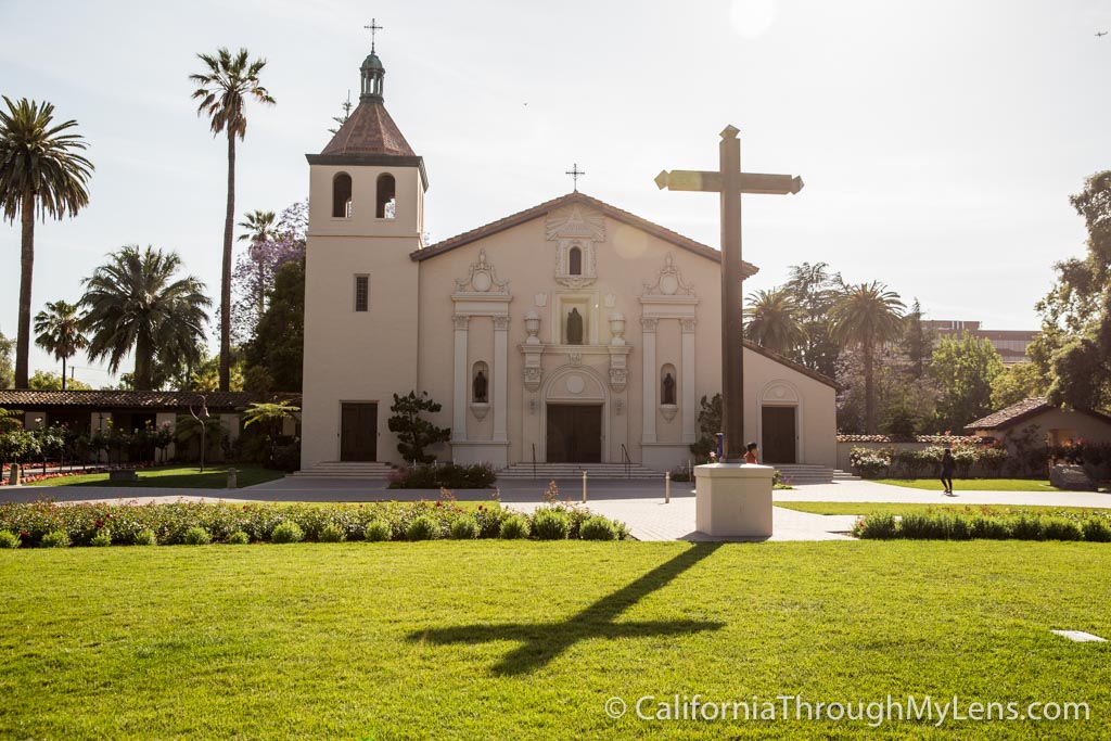
California Missions: How to Visit All 21 & Road Trip Along El Camino Real
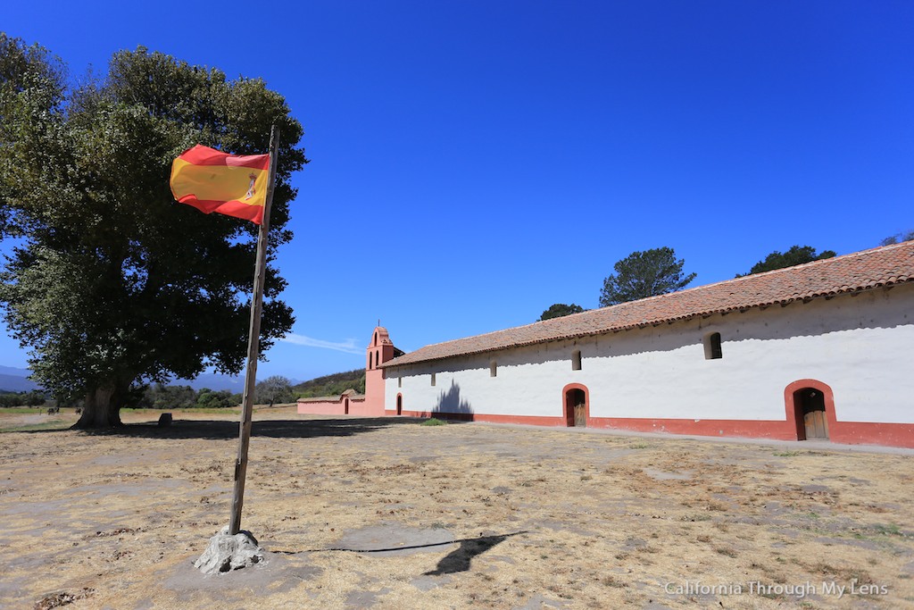
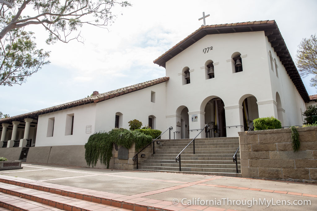
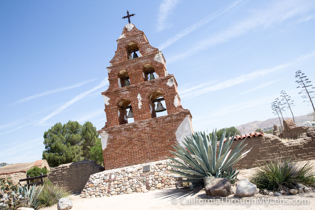
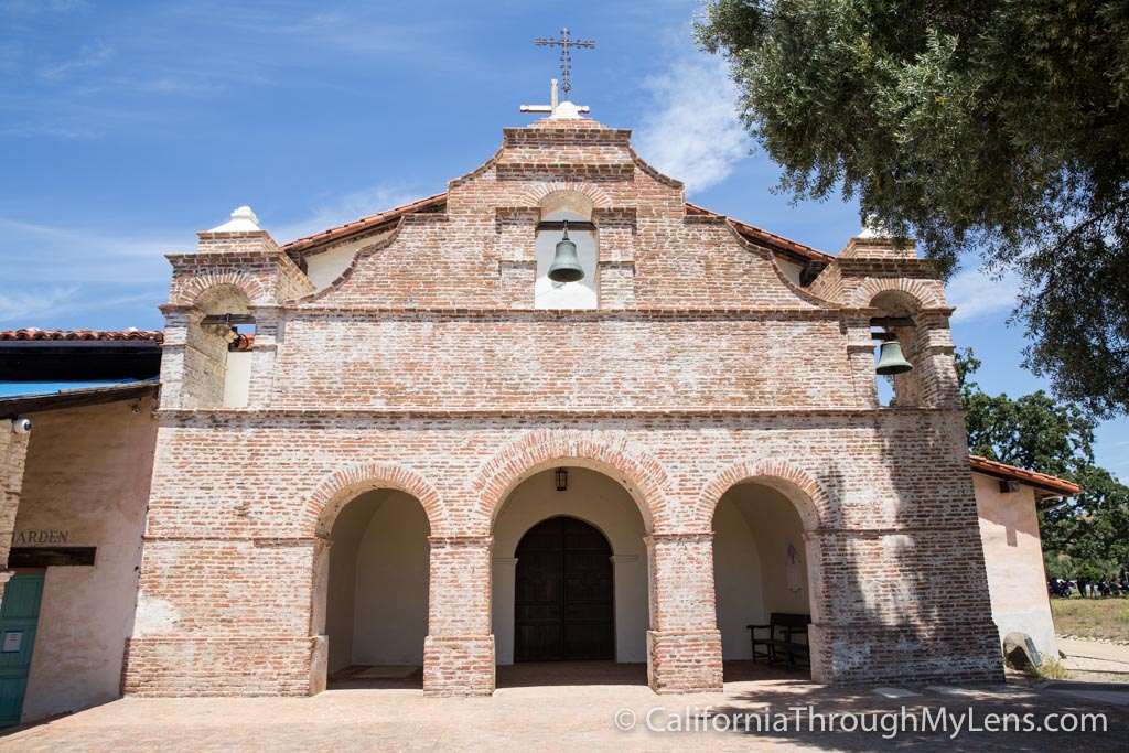
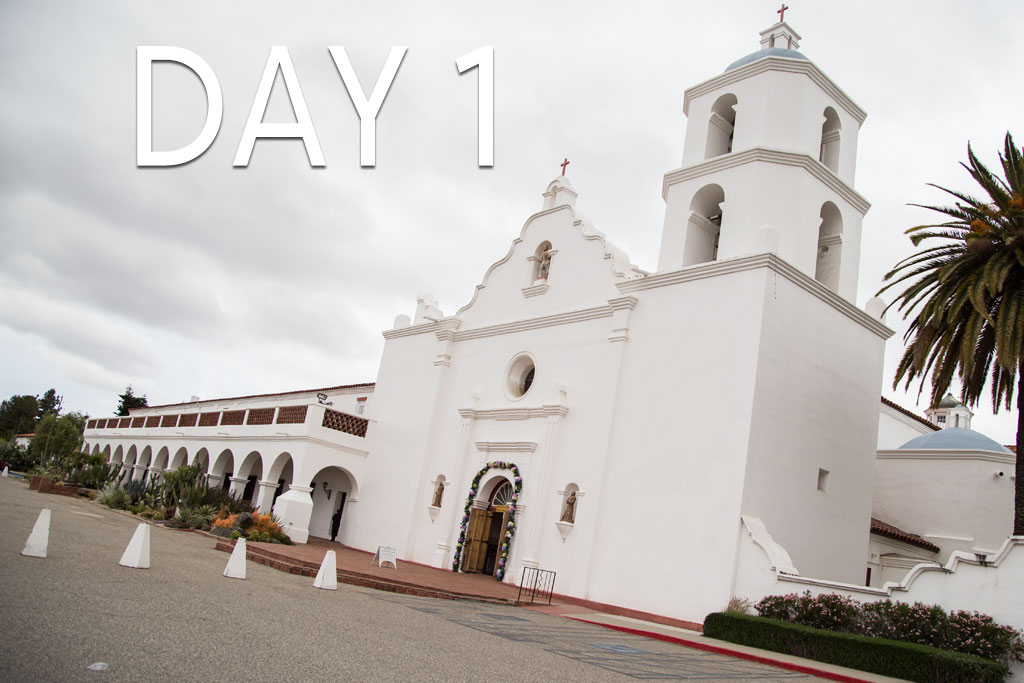
The twenty-one California Missions, from the time when Spain controlled California, are some of the oldest pieces of history you can visit in the entire United States. A road trip to see all of them will take you over 600 miles from San Diego to Sonoma, and it will provide a plethora of adventure, history, and fun for the whole family. I did this entire drive in 7 days in 2016, and here is all of the information so you can do it yourself, or just read on to learn about a unique part of California’s past.
The 21 California Missions
Here are each of the 21 missions from south to north, click on the image to learn more about each one .
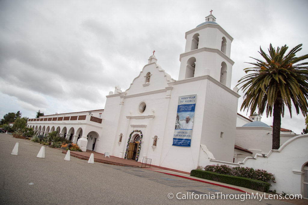
San Diego De Alcala
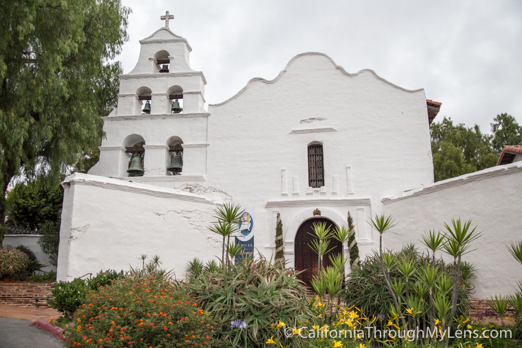
- Location: San Diego
- Founded Order: 1st
San Luis Rey De Francia
- Location: Oceanside
- Founded Order: 18th
San Juan Capistrano
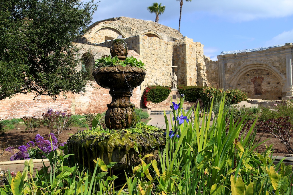
- Location: San Juan Capistrano
- Founded Order: 7th
San Gabriel Arcangel
- Location: San Gabriel
- Founded Order: 4th
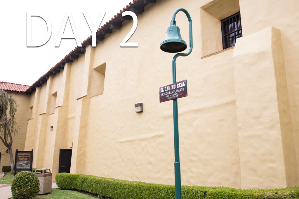
San Fernando Rey De Espana
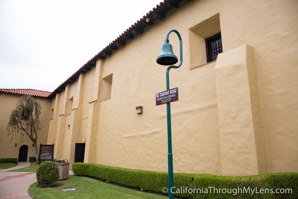
- Location: Mission Hills
- Founded Order: 17th
San Buenaventura
- Location: Ventura
- Founded Order: 9th
Mission Santa Barbara
- Location: Santa Barbara
- Founded Order: 10th
Mission Santa Ines
- Location: Solvang
- Founded Order: 19th
La Purisima Concepcion
- Location: Lompoc
- Founded Order: 11th
San Luis Obispo De Tolosa
- Location: San Luis Obispo
- Founded Order: 5th
San Miguel Arcangel
- Location: San Miguel
- Founded Order: 16th
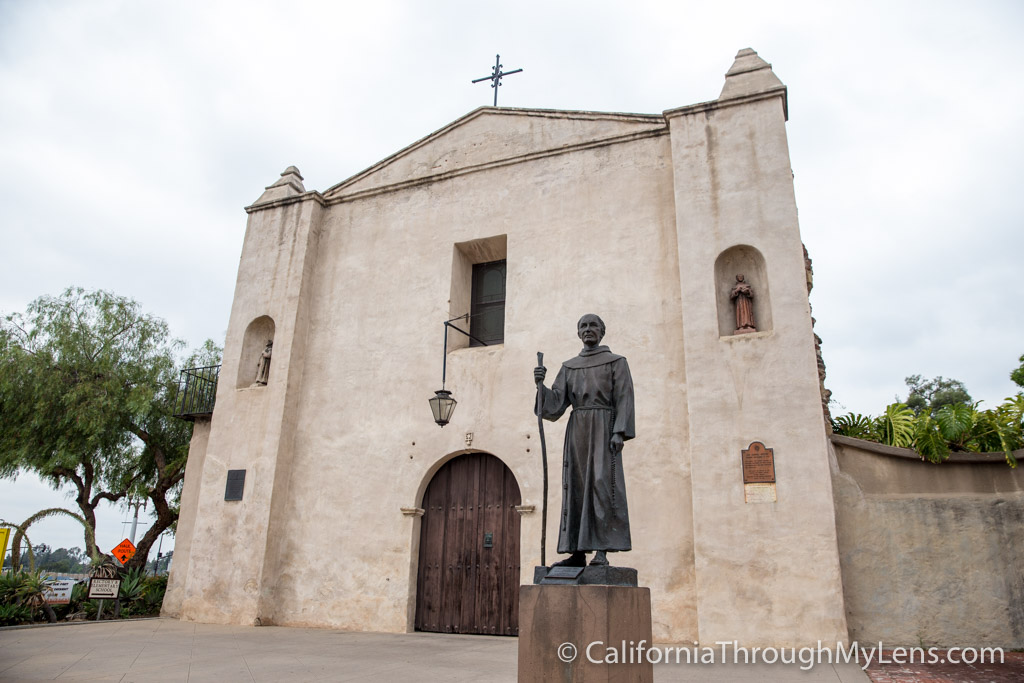
San Antonio De Padua
- Location: Jolon
- Founded Order: 3rd
Nuestra Senora De La Soledad
- Location: Soledad
- Founded Order: 13th
San Carlos Borromeo De Carmelo
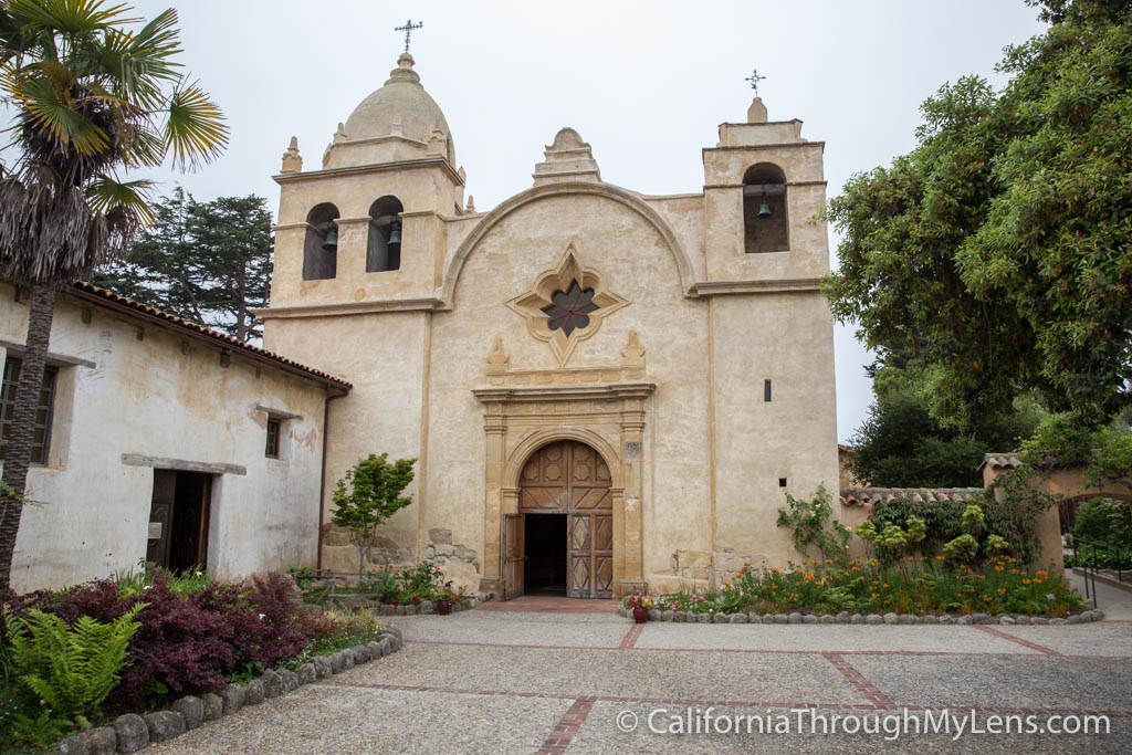
- Location: Carmel
- Founded Order: 2nd
San Juan Bautista
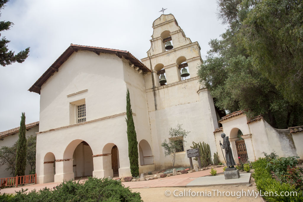
- Location: San Juan Bautista
- Founded Order: 15th
Mission Santa Cruz
- Location: Santa Cruz
- Founded Order: 12th
Santa Clara De Asis
- Location: Santa Clara
- Founded Order: 8th
Mission San Jose
- Location: Fremont
- Founded Order: 14th
San Francisco De Asis
- Location: San Francisco
- Founded Order: 6th
San Rafael Arcangel
- Location: San Rafael
- Founded Order: 20th
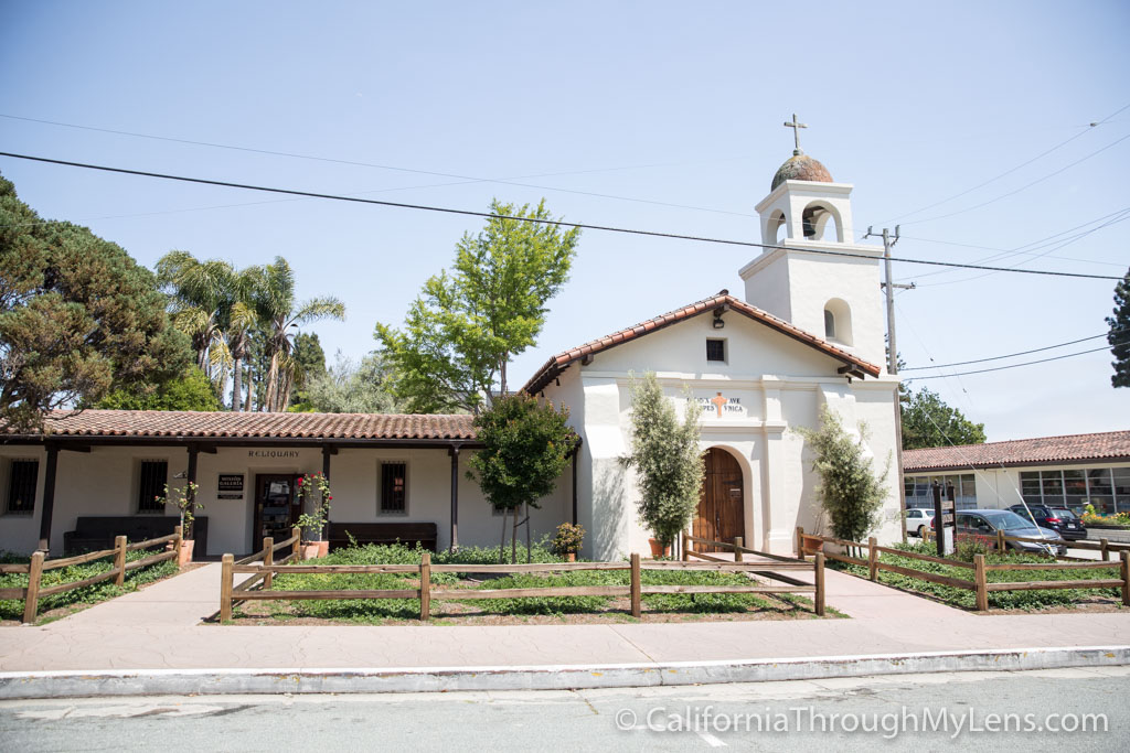
San Francisco Solano
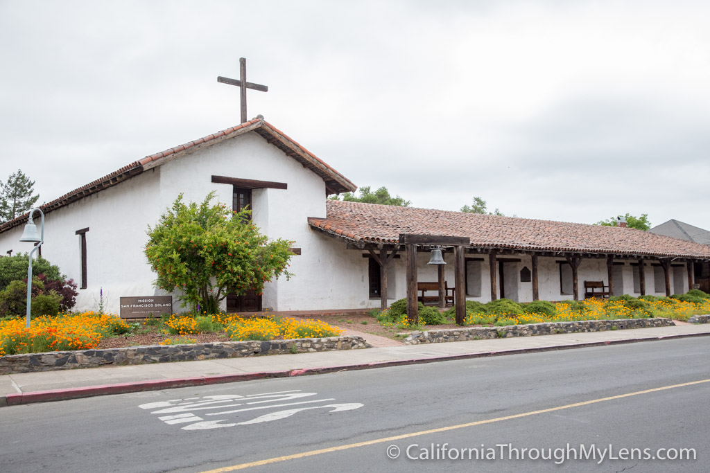
- Location: Sonoma
- Founded Order: 21st
California Missions Seven Day Road Trip Guide
Interested in visiting all of the California Missions yourself? I created the below itinerary for each day of my road trip. You can use them to plan your trip to visit each of the missions as I did.
San Diego to Pasadena
Pasadena to Ventura
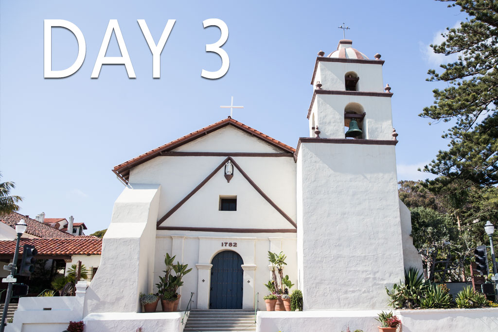
Ventura to San Luis Obispo
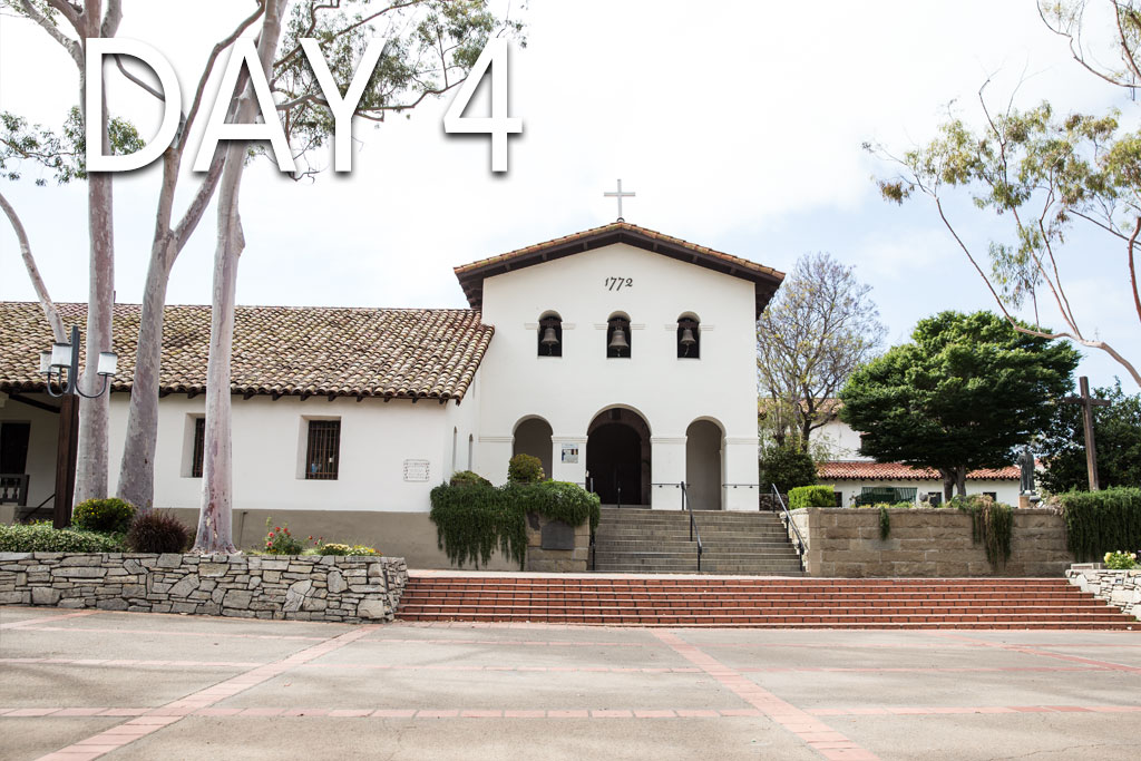
San Luis Obispo to Carmel
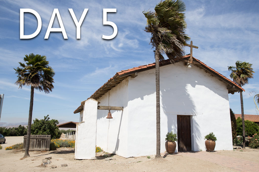
Carmel to Santa Cruz
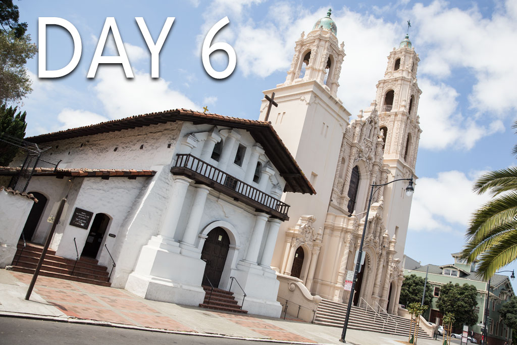
Santa Cruz to San Francisco
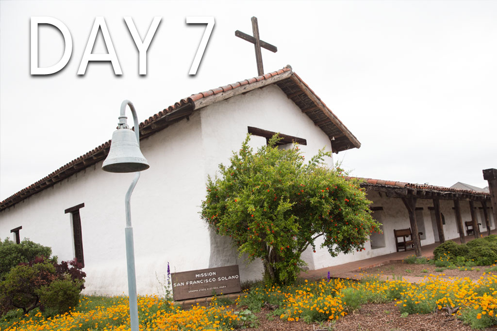
San Francisco to Sonoma
California Missions Videos
Interested in seeing the highlights from my time visiting all 21 missions or seeing my 10 favorite spots? Check out the videos below.
Mission Related Sites and Museums
Want to get more in-depth on your visit to the historic spots along El Camino Real? Here are a few of the places that are connected to the missions that you can still visit.
California Missions Museum
Junipero Serra Museum
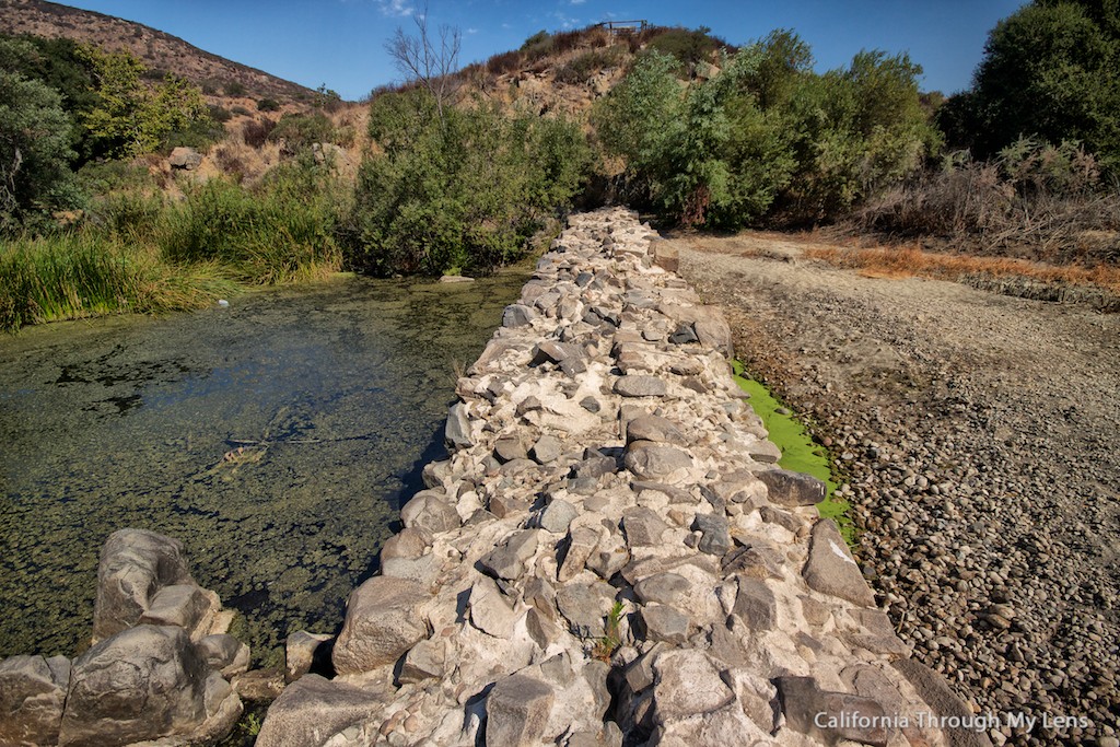
Old Mission Dam
San Antonio De Pala Asistencia
Map of the California Missions
Zoom in and out to look at the map see where each mission is, then click the icon to go to the specific post.
FAQ – California Missions Trail
While I was driving along the El Camino Real, I got a lot of questions from people related to the missions, their history, and what they have in common. Here are some of the main questions. If you have one that was not answered, be sure to leave it in the comments.
What can I collect from all of the missions?
The closest I could find to something that every mission sold was small silver medallions that have the mission’s saint and a picture of the mission on them. They go for $1 – $3 depending on the mission and I got them from 17 of the 21. Two of the others were sold out, and two just didn’t have them at all. I couldn’t find anything else that almost every mission had to collect.
How much did it cost?
I paid for the whole trip myself, and I estimate it cost around $800 for gas, food, hotels and mission entrance fees for the trip. I was by myself, so the food cost would increase if you had other people with you of course.
Where can I find out when the missions are open?
I found the missions to be open more than I anticipated they would be, as I assumed it would be harder to plan then it was. That being said I would recommend Googling each before going so that you can see up to date information on their hours.
Are any of the missions hard to get to?
The only one that is somewhat difficult to get to is Mission San Antonio de Padua. Mission San Antonio de Padua is located 26 miles each way off Highway 101. While the drive to get there is not difficult, it can be hard to fit into a typical road trip just because of the time commitment needed to get there and back. The rest are all located close to the main highway.
I don’t like the mission history, so why should I go?
Even if you do not agree with what the missions did, they are still a very influential part of California’s history. The missions have beautiful architecture and are some of the oldest buildings in the state. I recommend you visit a few of them and I bet you will find something to enjoy.
What are some other good resources on the missions?
I would recommend picking up this book on the missions as I took it with me and read about the ones I would be visiting each day. This website also has a lot of great information as well.
History of the California Missions
California missions of Alta California (“New Spain”) tell a story of state and national evolution. Missions built in the 18th and 19th centuries still remind Californians and visitors of the European explorers who came by sea and land to conquer a new land. Under Spanish rule, the first California mission fort was established. Both armed forces and Franciscan shepherds came to colonize California outposts and to convert Native Americans to the Christian faith.
The first California missions were settled within about seven years prior to the Declaration of Independence in 1776. The last missions were established several decades before gold was found in 1848 at Sutter’s Mill. Expansion of California missions ended in the early 1820s in Sonoma. Over more than five decades, at least twenty-one missions and four forts, called presidios, were built along California’s coast.
The first nine missions were established by Saint Padre Junípero Serra. The next nine were founded by his colleague, Padre Fermín Francisco Lasuén. The final three missions were established by others.
Earliest California Missions
The earliest California missions were built between 1769 and 1777:
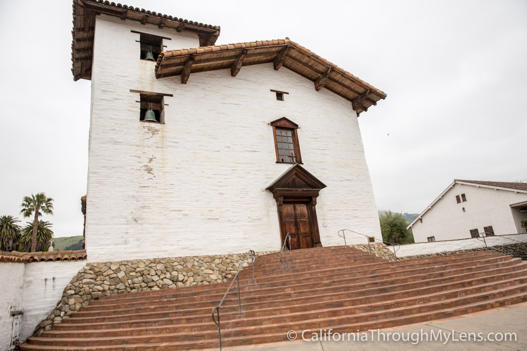
The first California Mission San Diego de Alcalá, was named for a 15th century Spanish saint. The location was chosen to provide easy access by sea to Alta California from Spanish Mexico. During a severe drought, the Franciscans were forced to move the mission six miles from the coast. Then, in 1775, natives sacked and burned the settlement. Saint Padre Serra’s residence was the only structure to partially survive the attack. After military occupation in the 1840s – 1850s, President Abraham Lincoln released the mission to the Catholic Church once more in 1862. Today, San Diego rests at the top of a hill on the original mission site in San Diego Presidio just east of downtown. Mass and feast day schedules are found on the mission website.
The second , Mission San Carlos Borromeo del Río Carmelo, was also founded by Padre Serra in 1770. He was considered a saintly man by all who knew him in life. The Catholic Church conferred sainthood in 2015. Leaders in Spanish Mexico chose the location of the mission with care and, for many years, it was considered the headquarters of the California missions. The mission built the first library of thirty books in 1778. As more American settlers came west, the mission was secularized in the 1830s. Until after the Civil War, the original mission was abandoned. Saint Padre Serra is buried in this beautiful place.
The third and fourth California missions were established in 1771. Mission San Antonio de Padua’s position was strategically chosen as a key central California location by Spanish Mexico. Named for the Catholic saint, Anthony of Padua, it was the first mission to use now-traditional red tile roof to protect inhabitants from water and fire. The settlers installed an aqueduct system. Franciscan fathers taught indigenous residents religious songs through an ingenious color system. One of the first known marriages in early California was celebrated here in 1773.
The fourth California mission, Mission San Gabriel Arcángel, was named for the archangel Gabriel. San Gabriel’s position was the crossroads of three vital land trails. The mission moved three miles inland within decades of the original settlement. More than 6,000 Native Americans were buried on mission grounds. In the 18th and 19th centuries, the mission was known for its vineyard and wines.
The fifth , Mission San Luis Obispo [de Tolosa,] was established in 1772. During a food shortage, mission settlers hunted bears in the nearby “valley of the bears,” Los Osos. The mission vineyard was so productive that, by the 19th century, wine was exported to Russia and Great Britain. Because the Vatican declared that a church could only be as high as trees surrounding it. The mission’s walls are built as tall as local pine trees of the day (50 – 60 feet).
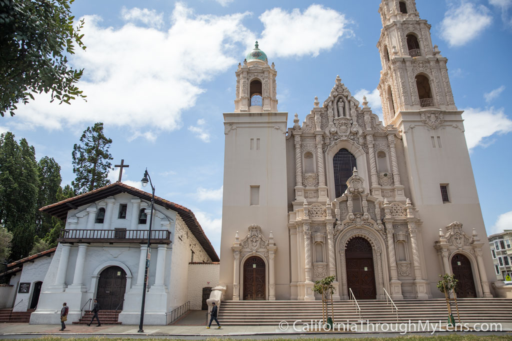
The sixth California mission was established in 1776 at the conclusion of the American Revolutionary War. Mission San Francisco de Asís, named for Catholic saint Francis of Assisi, saw the city of San Francisco grow around it. Original mission settlers had friendlier relations with local Native Americans: the beautiful mission ceiling was actually rendered by Indian artisans. Thousands of Native Americans are thought to be buried on the mission ground. Although mission priests wanted to move in search of a healthier climate, the mission remained in its original location.
The seventh California mission, Mission San Juan Capistrano, was named for Catholic saint John of Capistrano and provided access to southern California to Spanish Mexico. The chapel built by Saint Padre Serra is the oldest intact structure in California. The mission church’s original altar came from Barcelona. A statute of Saint Peregrine, patron of cancer victims, remains in the chapel. The mission successfully planted a vineyard and produced wine. Mission inhabitants used furnaces imported from Spain to convert ore to iron.
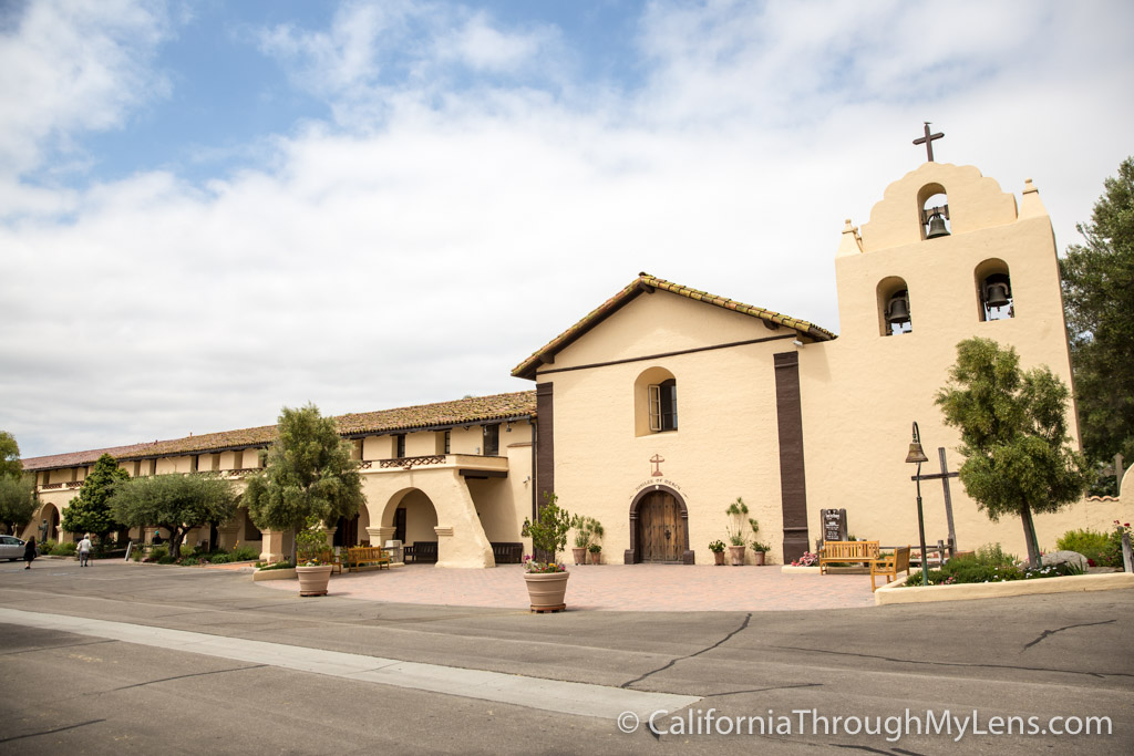
The eighth California mission was established the next year in 1777. Mission Santa Clara de Asís was named for St. Clare, the founder of the “Poor Clares” order of Catholic nuns. Today, the mission remains next to the oldest university in California, the University of Santa Clara. Floods and earthquakes besieged original inhabitants, and temporary relocations occurred from time to time. The Franciscans used cactus-based paint to make the chapel vibrant and colorful.
“Forgotten” California Missions
Mission La Purisíma Concepcíon and nearby Mission San Pedro y San Pablo de Bicuñer, both founded around 1780, were short-lived. Both were constructed in the Yuma territory and, according to California State Archives historians, both are practically “forgotten.” Mission La Purisíma Concepcíon’s historic park commemorates the mission today. The original mission building no longer exists but there are pieces of the walls that can be seen at the original site.
Richard Yates devoted years to establishing the location of the Mission San Pedro y San Pablo de Bicuñer in the 1970s. In “The Journal of Arizona History,” (Vol. 13, No. 2, Summer 1972), Yates states he believes the mission was on the Colorado River at the California side, not far from the Laguna Dam.
California Missions of the 1780s
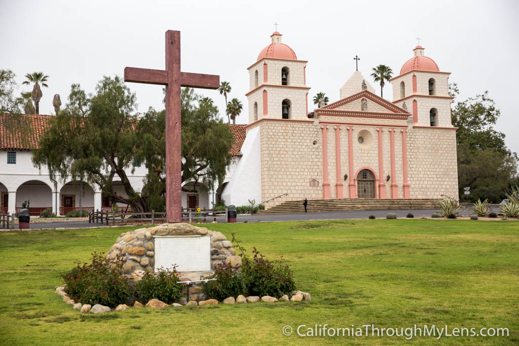
The Mission San Buenaventura (1782) and Mission Santa Barbara (1786), California missions nine and ten , were established next. Mission San Buenaventura’s restored buildings, grounds, and artifacts draw thousands of visitors each year.
Mission Santa Barbara, known as the “Queen” of the missions, assumed the central headquarters role within the mission chain by the late 18th century. Today, Mission Santa Barbara draws history buffs and the faithful from around the world. Check the mission website for information about church services and tours.
California Missions of the 1790s
The 1790s saw the establishment of Mission Santa Cruz and Mission Nuestra Señora de La Soledad. Today, Mission Santa Cruz’s Parish Chapel (Parish of the Holy Cross of the Catholic Diocese of Monterey) is a popular wedding site. Mission Nuestra Señora de La Soledad is a popular tourist attraction today. Volunteers operate a gift shop and maintain the grounds.
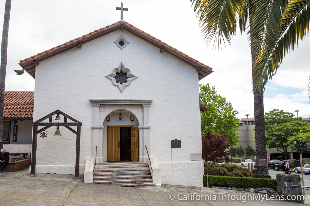
Four missions–Mission San José, Mission San Juan Bautista, Mission San Miguel Arcángel, and Mission San Fernando Rey de España–were all established in 1797; and San Luis Rey de Francia followed in 1798:
- Mission San Jose is a spiritual and cultural center now. To reserve a guided tour or to inquire about genealogy searches, contact the mission.
- Mission San Juan Bautista is an active religious community today. Contact the mission about schedules but keep in mind that San Juan Bautista mission is also affiliated (but not directly part of) the California Parks System.
- Mission San Miguel Arcángel is a historic landmark and religious community. A costly restoration project hopes to preserve the mission.
- Mission San Fernando Rey de España celebrates mass and offers visitors with access to its archives by appointment.
- Mission San Luis Rey de Francia was considered the “King” of California missions because of its large size. The first known pepper tree planted in California is found here. Mission San Luis Rey de Francis is a retreat center today.
California Missions of the 19th Century
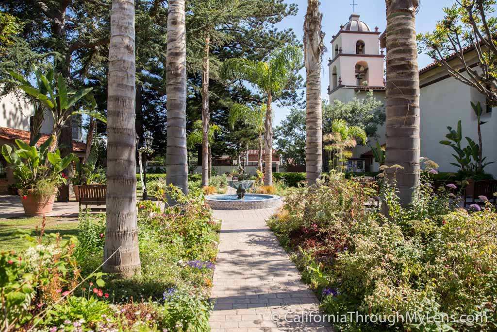
The last three California missions were built within the first quarter of the 19th century. Mission Santa Inés (1804), Mission San Rafael Arcángel (1817), and Mission San Francisco Solano (1823) came next.
- Mission Santa Inés was the last southern California mission. Named for the Catholic saint Agnes, its nearby neighboring town was founded by Danish settlers. The chapel was painted in bright colors. Like many California missions, Santa Inés had a vineyard and made wines.
- Mission San Rafael Arcángel was named after Rafael the archangel. Residents of the mission treated thousands of natives during the smallpox outbreaks of the 1820s. Originally named as mission resource, or“Asistencia,” in 1817, San Rafael was named to full mission status in 1822. Hearst Foundations rebuilt the razed original buildings in 1949.
- Mission San Francisco Solano, named after a Peruvian patron saint, was the final California mission. The “eye of heaven” positioned above the altar was said to represent God’s watching over the church. The location of the mission in Sonoma intersected many mission trails in northern Alta California. When California declared independence from Mexico in 1846, the new flag was hoisted over Mission San Francisco Solano.
California Missions Challenges
California’s weather was unpredictable to California mission settlers. Earthquakes and inclement weather created the need to constantly repair the chapels, churches, and residences. Drought, hunger, and fire occurred on the missions. Later missions included aqueducts to provide a steady supply of water. Filtration systems were in occasional use.
Relationships between natives and mission settlers were cordial in some areas and hostile in others. Thousands of indigenous Americans were buried on mission grounds.
Importance of the California Missions
The establishment of California’s missions provides a tangible representation of California’s history. Over time, cities sprang up around the missions and became today’s largest cities, including San Francisco, San Diego, San Jose, and Santa Barbara.

What’s your favorite mission? Do you have a different spot to recommend? Leave a comment below.
Similar Posts

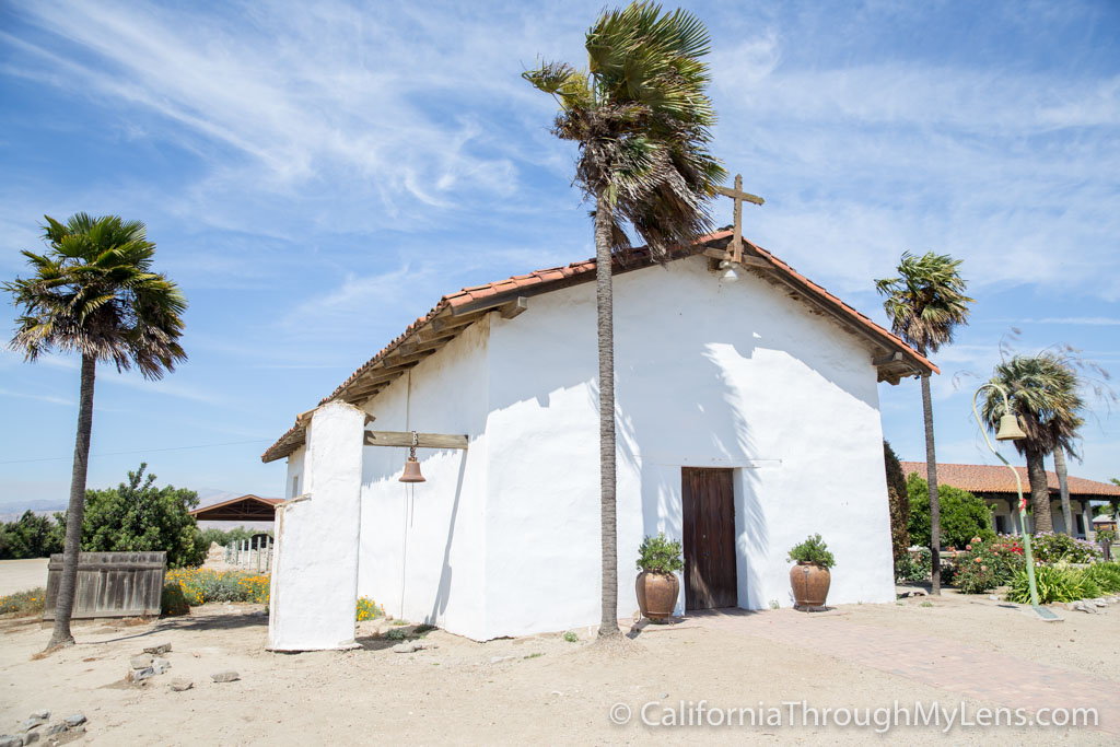
Mission San Antonio de Padua: California’s Third Mission

Highway 101 Road Trip: Los Angeles to J. Lohr Winery in Paso Robles

California Missions Road Trip Day 3: Ventura to San Luis Obispo

Mission San Buenaventura: Visiting the 9th California Mission

Mission San Fernando Rey de España in Los Angeles County

Mission San Luis Obispo de Tolosa: The Fifth California Mission
The Ultimate Pacific Coast Highway Road Trip Planner
Planning to go on the best road trip in the world? You have come to the right place.
Welcome to our ultimate Pacific Coast Highway road trip planner!
We are the #1 resource dedicated to planning a road trip along the Pacific Coast Highway.
Pacific Coast Highway road trip ranks pretty high among bucket list travel experiences – in fact its one of the most scenic drives in the entire world!
Highway 1 is a gorgeous drive along sprawling cities, charming coastal towns, beautiful beaches, majestic forests, and stunning landscapes.
Whether you are planning a trip to California, Oregon, or Washington….
….or planning the ultimate West Coast Road Trip from San Diego to Seattle;
We have multiple Pacific Coast Highway road trip itinerary recommendations that cover different areas of the West Coast!
That means you can use this as a Washington / Oregon Highway 101 road trip planner or California coastal road trip planner for Highway 1.
This Pacific Coast Highway road trip planner will help you plan your entire trip and cover the following:
- The Best Cities to begin your Pacific Coast Highway Road Trip
- Best PCH Itineraries for all types of travelers
- Best Stops / best attractions to visit on the Pacific Coast Highway
- Where to stay along the Pacific Coast Highway
- Best places to eat along the Pacific Coast Highway
- Hidden Gems / Offbeat attractions along the Pacific Coast Highway
This Pacific Coast Highway road trip guide also covers other useful and important information including
- Best time to visit the Pacific Coast
- How much to drive each day along the PCH
- What to pack for Pacific Coast Highway road trip
- How much does a Pacific Coast Highway road trip cost aka Budgeting for your PCH trip
It is quite easy to plan a PCH road trip by yourself using our Highway 1 / Highway 101 trip planners and online booking sites to reserve your flights/rental car/hotels.
Awesome, right? Then let’s start planning your Pacific Highway road trip itinerary now.
Before you begin
As an American, you probably know what goes into planning an epic cross country road trip.
After all, we are pretty road-trip obsessed country!
However, what if you are traveling from abroad and are interested in the Pacific Coast Highway drive itinerary?
You’re in luck – we have many resources to help you plan your trip including information on visas, renting a car, and driving in America.
Our detailed PCH road trip planners will take you step by step through the process of planning your trip:
- The initial steps in planning the Pacific Coast Highway road trip involve: Deciding what part of the PCH will you drive How many days will you devote to the entire trip and When is the best time to visit. Information to help you in deciding these is covered in Step 1: PCH FAQs and Step 2: Best PCH Stops
- You also need to pick a PCH gateway city, decide how will you reach there, and whether you need to rent a car or drive your own. Find information on the best cities to start your PCH Road Trip in Step 3: PCH Gateway Cities
- If you want to see the highlights of central California, specifically Highway 1, then refer to the California coast road trip planner. If you want a Pacific coast trip through PNW, then focus on the Oregon coast and Olympic peninsula. Information on specific Itineraries is covered in Step 4: PCH Itineraries
- Finally, book your trip! Find our recommended hotels, car rental companies, and flight aggregators in Step 5: Book your PCH Road Trip .
Also, don’t forget to join our Pacific Coast Highway Road Trip Facebook Page where you can ask questions or share your photos or itinerary with fellow travelers. Click here to join now .
Ready to get started? Let’s start planning the ultimate Pacific Coast Highway road trip together!
Don’t believe us when we say that the PCH road trip is the most beautiful road trip in the world?
Then check out these beautiful photos from the USA West Coast!
Step 1: PCH FAQs
The Pacific Coast Highway is pretty large and rather confusing.
It is essential to understand the PCH before you plan a trip.
Here’s some basic information:
Where does the Pacific Coast Highway start and end?
Wondering where is the Pacific Coast Highway and how long it is? Also, where does the PCH start and end?
One of the things that creates confusion while planning a Pacific Coast Highway road trip is that the road is simply huge.
Plus everybody seems to be talking about a different stretch of the road when they refer to the PCH.
We experienced this several times while planning our first trip to the region.
The coastal route or the PCH starts at San Diego near the Mexican border and ends near Seattle in the city of Olympia in the Pacific Northwest.
It is not officially named the Pacific Coast Highway but has always been called so since it parallels the Pacific Coast.
The routes to follow for the road trip include Highway 1 in southern and central California and Highway 101 in northern California, Oregon, and Washington.
How long is the Pacific Coast Highway?
Since it goes the entire length of the West Coast, just how long is the Pacific Coast Highway?
The road beginning in San Diego to its end in Olympia, the capital of Washington State is roughly 1700 miles long!
And yes, it really does go parallel to the Pacific Ocean for the most part!
What is the PCH1?
The road officially called the PCH1 is located in California. Its other name is California State Route 1 (SR1) or Highway 1.
Where does Hwy 1 start and end?
The PCH1 drive extends from the I-5 intersection in Orange County, Southern California to Highway 101 intersection near Leggett in Northern California.
Also, the name PCH 1 is interchangeably used with Highway 1 (Hwy 1) or Route 1 or California 1 or SR 1.
Add to that, certain parts of California PCH 1 near Pismo Beach on Central Coast are known as Cabrillo Highway while a section north of San Francisco is called the Shoreline Highway.
Many times Hwy 1 merges with Hwy 101, creating even more confusion.
This is most noticeable from Pismo Beach to San Luis Obispo and along the Golden Gate Bridge where the two roads merge.
The Hwy also simply disappears and takes street names in San Francisco (19th Avenue) and in Santa Monica (Lincoln Blvd).
If you are planning a trip along this route, then the Highway 1 trip planner will help you discover attractions between Los Angeles and San Francisco.
So how do you ensure you don’t get lost while planning a road trip up PCH?
The easiest way is to ensure that you are following the PCH1 between Monterey and San Luis Obispo in California.
This is the most spectacular stretch that passes through Big Sur and the road here is clearly marked, causing no confusion.
Our California Highway 1 road trip planner will guide you towards the best stops on Highway 1 California in Big Sur including McWay Falls and Pfeiffer Beach.
Which section of the Pacific Coast Highway should you drive?
For first-timers, we recommend driving the California Highway 1 or PCH 1 from San Francisco to Los Angeles for multiple reasons.
This stretch of PCH1 passes through the beautiful Big Sur region.
For many people, Big Sur is the #1 attraction along the route.
Also, the gateway cities of Los Angeles and San Francisco are very well connected and easy to fly in or out after your trip.
One-way car rentals between the two cities are easily available or you also have the option of a loop road trip.
Our San Francisco road trip planner will help you plan your trip to SF, LA, as well as the attractions in between.
Have already been to this part of California Coast? Don’t want to begin in SF? You have many other options to customize the itinerary as you want!
After the PCH 1 ends, you can either drive south along the coast to San Diego or all the way up to Olympic National Park and the Canadian border in the north.
Alternatively, you can also begin the Pacific Coast Highway road trip from San Diego and drive north.
The entire route is scenic and has plenty of attractions.
In northern California you will find beautiful redwood trees while in Oregon, you can see stunning capes and lighthouses as well as unique geological formations.
In Washington, you will find everything from deep blue lakes and dense rainforests to sea stacks and driftwood covered beaches.
And that’s why it is so important to decide which stretch of the Pacific Coast Highway you want to drive before you plan your trip.
Which direction to drive the Pacific Coast Highway?
All right, so you have decided which section of the Pacific Coast Highway you are going to be driving.
You know how much time you have in hand.
So which gateway city do you begin your PCH Road trip?
Is it better to drive north or south on the Pacific Coast Highway?
While many people recommend driving from south to north, our favorite is to drive south.
Yes, you will see the most gorgeous sites first and might end in the chaotic city of Los Angeles but you will be closer to the stunning views plus have easier access to parking lots and pull-outs.
That being said, if you have enough time to savor the trip then the direction won’t really matter much!
When to visit the Pacific Coast Highway?
The best part? You can drive the Pacific Coast Highway year round!
There are, however, certain times of the year when the PCH road trip is more scenic than others.
Spring is our personal favorite.
You can see wildflowers along the Pacific Coast Highway plus spot wildlife including migrating whales.
The temperature is pleasant for hiking, during the daytime it is neither too hot nor too cold.
An added bonus, the crowds are fewer than in summer or winter holidays.
However, you should skip spring break week, if possible.
Remember: Spring can be too windy and cold but the gorgeous wildflowers tip the scales.
Our second favorite time of the year for this road trip is from late summer to early fall, just after the schools are in session.
September and October on the coast are mild and sunny.
A pleasant breeze flows from the ocean making hikes more fun.
Wineries along the PCH in Napa, Sonoma, and along the Central Coast have beautiful fall colors and are ready for harvest.
Visitors can enjoy grape stomping at wineries if they time it right.
Winter and summer both have their pros and cons.
In winter, you can whale watch and enjoy the scenic beauty without the fog.
But temperatures, especially for northern California, can be quite chilly.
It can also rain, causing landslides and slippery trails.
The PCH may stay closed for days due to extended storm damage.
The very end of winter – from mid to late February – is a good time with mild weather and low crowds.
The summer months of June, July, and August can be quite foggy.
Big Sur looks beautiful and dramatic in the fog but the roads can be treacherous for driving.
The fog usually prevails in the morning and evening so you should still have clear blue afternoons.
As you continue south, it can get too hot to hike or stay outdoors for longer times.
Peak tourist times are winter holiday season and summer vacations.
Expect accommodations to fill up faster, potential delays on the road, and full parking lots at major attractions like Bixby Bridge and McWay Falls.
To read more about the best time to visit and see photos in different seasons, read our post When to Drive the Pacific Coast Highway .
How to rent a car for a PCH road trip? Which car should you rent?
The best way to travel Pacific Coast Highway is by car!
Look for one way car rentals unless you plan to do a round trip.
However, one-way rentals can be expensive so factor that in while planning your itinerary.
If you have more time and want to do the Pacific Coast Highway road trip on a budget, then you can definitely return to the original destination to reduce costs.
An SUV is really useful while negotiating the twisting turns of the PCH however, it is also easy to break in into.
Because of that, we prefer a sedan if we are driving with kids and have a lot of luggage in the trunk.
A muscle car or a convertible is also a great option for driving the Pacific Coast Highway.
The coast has stunning views and a top down lets you feel the ocean breeze and enjoy the panorama.
A recently popular option is to rent an RV for the Pacific Coast Highway travel itinerary.
This allows you to enjoy the natural attractions along the coast to the maximum.
How much should you budget for Pacific Coast Highway road trip?
The famous question, how much does it cost to drive the Pacific Coast Highway?! Or what should be your Pacific Coast Highway road trip budget?
In general, we recommend budgeting $200 per person per day including hotel, car, and food for road tripping the Pacific Coast Highway.
That’s why the easiest way to do the trip on a budget is to choose a shorter Pacific Coast Highway trip itinerary.
The fewer number of days on your trip, the fewer the costs.
That said, California, in general, is expensive and we have never been able to go on an extended California trip under $1000 per person including airfare.
You can also consider road tripping the PCH 1 along Oregon or Washington to reduce costs as these states are somewhat cheaper than California.
More Pacific Coast Highway FAQs
To read more Pacific Coast Highway FAQs including the following common doubts, click here .
- Is the Pacific Coast Highway dangerous to drive?
- What should you not miss on the Pacific Coast Highway?
- Which part of California should you visit?
- How long does it take to drive the entire Pacific Coast Highway?
Step 2: Best PCH Stops
If you have decided to visit the most popular part of coastal California:
Begin your Pacific Coast Highway road trip planning by exploring the major attractions and things to do along California’s Hwy 1.
Popular attractions including West Coast lighthouses , waterfalls, state parks, hiking trails, beaches, coastal towns await you on this marvelous drive – and off course the iconic Bixby Bridge!
You can find information about these and other essential attractions in our California Coast trip planner.
Also, explore other stops on Highway 101 in northern California if you have more time.
Here you will find majestic redwood trees and the Redwoods State and National parks.
Road trip the Redwoods Scenic Byway and explore cities like Eureka and Crescent City.
There are also plenty of stunning stops along the Pacific Coast Highway in both Oregon and Washington.
You can read more about the best stops along the PCH here.
This will give you an idea of the most important places to visit and help in planning the trip around your interests.
Step 3: PCH Gateway Cities
Once you have selected your itinerary, you need to select which West Coast cities you can fly into.
While there are many cities on the West Coast, the 5 major ones which make perfect places to begin your PCH road trip are these:
Begin a Pacific Highway trip around the Evergreen State in the Emerald City of Seattle.
Read our post on things to do in Seattle now to plan your trip.
To see Oregon’s dramatic coastline, redwood trees, rock formations, and sand dunes, start a Hwy 101 road trip in Portland.
Read our post on Things to do in Portland now.
San Francisco
San Francisco is our personal favorite to start an epic Pacific Coast road trip.
It also makes an excellent starting destination for California fly drive route planner.
Read our post on things to do in San Francisco now.
Los Angeles
Tinseltown is exciting and glamorous.
It also happens to be cheap to fly into and makes a perfect start to PCH drive.
You can plan a California coastal highway itinerary up or down the coast and have whale of a time.
Read our post on Best Things to do in Los Angeles now.
San Diego is the perfect destination to plan a trip using our SoCal trip planner.
Read our post on Best Things to do in San Diego now.
How to reach the PCH Gateway Cities?
The major airports for road tripping the Pacific Coast Highway 1 in California are San Francisco and Los Angeles.
San Francisco actually has three airports: San Francisco, Oakland, and San Jose.
You need to research airfares to all three to ensure you are getting the best deal.
Similarly, Los Angeles also has a couple of nearby airports including Long Beach, Burbank, Orange County, etc and is a great California PCH trip start point.
If you are extending your trip along the West Coast, then fly into San Diego, Portland, or Seattle to start your Pacific Coast Highway road trip itinerary.
Budget airlines that often have great deals to California or the Pacific Northwest include Frontier Airlines, Spirit Airlines, Alaska Air, and Southwest.
To get the best flight deals, we recommend booking using flight aggregators like Skyscanner or CheapOair.
Step 4: PCH Itineraries
This is our favorite part of trip planning!
This is also where we can help you the most as we have been planning road trips since the past 12 years.
We recommend that you go through our many itineraries, pick the one that is the best fit, and customize it to suit your needs.
Let’s plan the perfect Pacific Coast Highway road trip ever!
Fly and Drive PCH Itineraries by number of days
Since you will already be driving a lot every day along the PCH we generally recommend fly and drive itineraries.
However, if you happen to live nearby or have enough time to travel, then you can definitely drive to California and then go on the Pacific Coast Highway road trip.
You can spend anywhere from 4 days to 10 days on the Pacific Coast Highway.
Here are the highlights of our popular itineraries.
Click the link to read in-depth each itinerary for Pacific Coast Highway.
Pacific Coast Highway 4 day itinerary
The simplest California road trip planner.
If you have only 4 days, then spend one day in San Francisco and see the highlights including the Golden Gate Bridge, Lombard Street, Fisherman’s Wharf, and Alcatraz.
Visit one of the beaches: Ocean Beach, Crissy Field Beach, or Baker Beach are the most popular ones!
The next day, leave early from San Francisco and explore Half Moon Bay and Monterey.
See the Monterey Bay Aquarium and Cannery Row, visit the sandy beaches of Half Moon Bay, and take some time to explore Santa Cruz or Pebble Beach.
Stay the night in Carmel or Monterey and leave early for Big Sur.
See Bixby Creek Bridge, hike McWay Falls, spend time at San Dollar Beach before reaching San Luis Obispo for the night.
Spend some time to see SLO attractions including Mission San Luis Obispo de Tolosa, Historic Downtown, Bubblegum Alley, and the Madonna Inn – a famous hotel with eclectic decor!
Then stop at Santa Barbara. Sandwiched between the Pacific Ocean and the Santa Ynez mountains, this coastal city feels very Mediterranean.
Santa Barbara has many attractions including the charming white colonial downtown, Mission Santa Barbara, museums, zoo, and more!
Enjoy shopping or dining at Stearns Wharf or take a whale watching cruise before heading for Los Angeles.
In Los Angeles, visit the Walk of Fame, see Griffith Observatory, and the Hollywood Sign before calling it a day.
You can read this itinerary here for this Highway 1 trip planner.
Pacific Coast Highway 5 day itinerary
Looking for Pacific Coast Highway itinerary of 5 days?
We would recommend following our 4-day pacific highway 1 itinerary with just a few changes: you can spend the extra day exploring either San Francisco, Big Sur Coast, or Los Angeles.
In San Francisco, use your second day to see Muir Woods, Mission District, Chinatown, and Twin Peaks.
If you chose to stay in Big Sur, then stay at the romantic Ventana Resort or Post Ranch Inn.
Stop at each pull-out and look for wildlife.
Tour the Point Sur Lightstation, photograph the Bixby Bridge, and see the seals at Elephant Seal Rookery in Piedras Blancas.
Make the detour to explore Central Coast’s wine country.
If you chose Los Angeles then the sky is the limit.
You can explore the museums especially the Broad and LACMA or spend a day at Universal or Disney!
If you ask us, we would pick Big Sur over the cities, any day!
You can read about this itinerary in detail here for the 5 Day PCH trip planner.
Pacific Coast Highway 7 day itinerary
Our favorite! A week is a perfect time to drive this stunning route.
On your first day of California pacific coast highway itinerary 7 days, start at the northern end in Leggett and see those majestic coastal redwoods.
Drive your car through the Chandelier Tree tunnel.
Then eat oysters in Tomales Bay and visit Point Reyes Lighthouse before spending the night in San Francisco.
For the rest of your coast to coast road trip planner, spend 1 day each in San Francisco, Monterey, Big Sur, Solvang, Santa Barbara, and Los Angeles.
With 7 days in hand, you have enough time to explore Big Sur’s hidden gems such as Henry Miller Memorial Library and Andrew Molera State Park.
View this itinerary now to read all the details of the 7 day Pacific Coast Highway trip planner.
Pacific Coast Highway 10 day itinerary
With 10 days in hand, you have so many options.
One way is to follow the 7- day itinerary but drive all the way down to San Diego to create the ultimate California driving trip planner.
Another is to start in Los Angeles, follow our 7-day itinerary heading north, and explore up to the Avenue of Giants in northern California.
If you love slow travel, then drive from Leggett to Los Angeles but spend time hiking in Point Reyes and Point Lobos, visiting the remote Channel Islands National Park, and touring the wineries of Santa Ynez Valley.
The epic 10 day California road trip for families and RVers.
The ultimate chilled-out California Pacific Coast Highway trip!
You can also do a Northern California road trip from San Francisco for the Pacific Coast Highway Itinerary 10 days.
Or you can drive all the way up to Portland and see the Oregon coast attractions along the way.
You can also visit the Olympic Peninsula on a Pacific Coast Highway 101 road trip in Washington.
To decide which itinerary to choose, click here now .
If you have less than 4 days
If your Pacific Coast Highway drive time is too long, then you won’t have enough time to enjoy all the attractions on the way.
We would not recommend driving the entire length of the PCH or Highway 1 if you have less than 4 days.
For short weekend trips, consider the below trips in our California road trip route planner.
We also suggestions for PCH day trips in Oregon and Washington.
Best PCH road trips from San Francisco
If you have 3 days or under, then it is not feasible to drive the entire length of PCH.
You can make the drive but will miss out on a lot of attractions.
Instead, consider day trips and weekend getaways along the coast for Pacific Coast Highway road trip itinerary 3 days.
Our top 3 getaways for Pacific Coast Highway road trip itinerary 1 day from San Francisco are Point Reyes, Monterey, and Big Sur.
Carmel by the Sea, only a short drive from Monterey and Pebble Beach, is also a great weekend trip from San Fran.
Best PCH road trips from Los Angeles
For day trips and weekend getaways along Hwy 1 from Los Angeles, consider visiting La Jolla, Malibu, Santa Barbara, Solvang, Pismo Beach, or San Luis Obispo.
Or drive south towards San Diego, Newport Beach, and La Jolla.
These destinations are just a few hours away from LA and great to visit.
Visiting Big Sur from Los Angeles is hectic if you have only 2 days but possible with 3 days in hand.
Best PCH road trips from San Diego
You can also road trip up the pacific coast highway from San Diego to Los Angeles or Anaheim.
Enjoy Hollywood or city life in Los Angeles or see Disney and other theme parks in Anaheim.
Relax at Huntington Beach. Or visit Coronado island for a different type of trip.
The San Diego trip planner has many ideas to enjoy the attractions of southern California.
Best PCH road trips from Portland
Combine a visit to Portland with an adventure down the PCH.
While you cannot use Portland to San Francisco road trip planner in just 4 days, you can visit Astoria or Cannon Beach.
Go hiking in Ecola State Park or drive the Three Capes Scenic Loop.
Best PCH road trips from Seattle
There are plenty of PCH trips from the Emerald City.
Drive the Highway 101 south to Tacoma or Olympia.
Or take the ferry to Port Angeles and Olympic peninsula and follow Highway 101 all around the peninsula.
If you have more than 10 days
If you have anywhere around two weeks, we would recommend driving either down to San Diego in the south or driving towards Portland or Seattle in the north from LA or SF.
You can also drive from San Diego to Seattle or vice versa using our west coast road trip planner.
2 Week West Coast Road Trip Itinerary
2 weeks is the ideal time to go on an epic US West Coast Road trip.
From the Olympic peninsula in Washington to southern California, you can use our border to border coast trip planner to plan the most amazing, once in a lifetime, USA West Coast Road Trip Itinerary.
You can either start in San Diego and drive towards Portland or Seattle or start in the Pacific Northwest and drive south.
The entire drive is over 1700 miles and should be done only if you have 2 weeks or more in hand.
Point to Point PCH Itineraries
You can also plan PCH road trip itinerary depending on your start city and destination rather than days.
Pacific Coast Highway Itineraries by State
San diego to los angeles drive.
Wondering how to plan a trip to California coast between Los Angeles and San Diego?
This California Highway 1 road trip itinerary will take you through stunning beaches of La Jolla, Laguna Beach, and Oceanside.
You can see charming coastal towns and enjoys SoCal’s relaxed vibe.
California Coast Road Trip from LA to SF
This is the ultimate CA road trip planner.
Visit two of California’s biggest cities and visit the natural attractions on the coast including beautiful Big Sur, McWay Falls, and 17 Mile Drive.
This Pacific Highway 1 road trip is our favorite road trip along the West Coast! Read this itinerary now.
Northern California Coast Road Trip
This Highway 101 road trip itinerary in Northern California will take you through giant, majestic redwood trees and the most remote parts of the coast.
From attractions like Point Reyes and Muir Beach to charming cities like Mendocino and Eureka, this itinerary for driving Pacific Coast Highway will leave you spellbound.
See the glass beach at Fort Bragg, tour the famous Point Arena Lighthouse, enjoy hiking at Mendocino State Parks, and drive the Avenue of Giants on this epic PCH itinerary.
Oregon Coast Road Trip Planner
Plan a trip from Brookings in the south to Astoria in the north using our Oregon Highway 101 road trip planner.
Visit attractions such as Cannon Beach, Natural Bridges, and Devil’s Punchbowl on this amazing Oregon Coast Road trip .
Washington Olympic Peninsula Road Trip
Our Highway 101 trip planner in Washington follows the road around the Olympic peninsula.
It can be used to visit attractions such as Ruby Beach, Hoh Rainforest, Hurricane Ridge, Port Angeles, and Seattle. Read this itinerary now .
We would recommend going through our list of Suggested PCH Itineraries and deciding upon an itinerary based on your interests before finalizing your trip.
Pacific Highway Road Trip Map
Looking for map of Pacific Coast Highway Road Trip?
Among our resources, we have plenty of Pacific Coast Highway road trip maps, depending on the section you want to drive.
If you are interested in Big Sur, use the California Highway 1 road trip map.
Use the Northern California road trip map planner to see the redwoods.
Follow Pacific Highway itinerary maps for Oregon or Washington to plan a Pacific Northwest trip.
Be sure to finalize your Pacific Coast Highway Map and print copies before you embark on your trip.
Step 5: Book your PCH Road Trip
And finally we come to the task of booking your PCH vacation.
When to book and plan your PCH trip
In general, we recommend booking your trip at least 6 months in advance, though ideally, earlier is better.
While you can always plan a last-minute PCH road trip, especially if staying nearby, it is not recommended.
This especially applies if you are traveling in peak periods and in the Golden State.
Every California trip planner suggests booking in advance.
As we have experienced, booking hotels closer to the trip can definitely make the trip twice as expensive.
Before booking your trip, we recommend researching destinations and finalizing your Pacific Coast Highway Road trip itinerary.
In some instances, we have booked first and then planned the trip but this can lead to more hectic trips.
Here’s what all you need to book for your trip.
Book flight tickets to the West Coast
For best deals, book your tickets to San Francisco, Los Angeles, Portland, or Seattle by checking on Skyscanner or Google flights.
Book car rental
All major companies have their branches in California.
You can rent from a variety of companies including Hertz, Fox, Enterprise, Dollar, and Thrifty for your trip.
Book hotel accommodations as per the itinerary
There are a variety of hotels, resorts, and motels for every budget along the PCH.
We have covered the best places to stay along the PCH in detail in this post.
Purchase travel insurance
We recommend getting travel insurance from World Nomads.
Purchase attraction tickets, if any
There are several attractions along the PCH for which you can purchase tickets in advance.
We recommend the advance purchase of tickets for attractions like the Monterey Aquarium, San Francisco museums, etc.
Purchase tours and cruises, if any
You can go on a variety of wildlife watching cruises along the PCH including whale watching, dolphin cruises, etc.
You can also reserve tickets for the Alcatraz cruise prior to your trip.
Recommended group tours
There are no tour companies that take you the entire length of PCH.
This is very much a self-drive trip.
However, there are companies that will take you to Malibu from Los Angeles or to Monterey from San Francisco.
Also in Monterey, you can take whale watching tours.
Reserve a table at restaurants, if needed
You will find amazing restaurants serving a variety of cuisine along the PCH.
Our favorites are seafood restaurants in Monterey, oysters in Tomales Bay, Mexican food in Mission District of San Francisco, and a variety of cuisines in Los Angeles.
If you like to plan every detail or want to plan for a special meal for birthdays or anniversaries, then you can reserve a table at the hotel of your choice in advance.
Prepare, pack, and go on the best road trip ever!
What other preparations should you make.
If you are traveling internationally then check your passport validity and visa status.
Apply for visas, if necessary.
Also, check whether you need IDP (International Driving Permit).
Other preparation includes print and/or having virtual copies of all maps, itineraries, tickets, and bookings easily accessible on your phone.
Also, budget your trip and convert currency, if needed.
Read below for more detailed information.
Understand internet and phone coverage
You will find that there is extremely poor and at times zero cell coverage along many stretches of the PCH, especially in the Big Sur region.
That’s why we recommend carrying a GPS in addition to your phone as well as saving offline maps on your phone.
You can also get printed maps of PCH1 for the section you are planning to drive.
If you are traveling internationally
The three main areas to take care of if you are traveling internationally include taking care of passports and visas, renting a car and driving in USA, and converting money to USD.
If you are traveling with kids
Pacific coast highway road trip with kids? Been there, done that!
Our final section of the ultimate Pacific Coast Highway road trip planner.
Did you know that you can drive the Pacific Coast Highway with kids?
The first time we went with our kids was when our daughter was just a 6 months old baby and our son was 3 years old.
We started in San Francisco, cycled the Golden Gate Bridge with the kids, drove through Big Sur, watched the elephant seals at Piedras Blancas rookery near San Simeon, and ended our trip at Anaheim in Disney.
Both the kids loved every bit of it.
Also, most places and businesses in California, Oregon, and Washington and especially along the Pacific Coast Highway are kid-friendly.
When we road tripped, most hotels provided crib or baby cots, all the restaurants had high chairs, and even the wineries had kid-friendly areas.
Throughout our trip, we met friendly people who smiled and waved at our kids.
We always felt welcome wherever we went and felt quite at ease.
Read our post on Best Kid-friendly resorts along the Pacific Coast Highway to book your accommodations.
There are so many things to do along the Pacific Coast Highway road trip that are perfect for the kids.
They will love exploring nature: hike through redwood forests, discover tide pool creatures, play in the sand and on the beach, splash in the water, hike to see waterfalls, whale watch using binoculars, plus spend quality time with the parents.
There are also many kid-friendly attractions on the route including the Aquarium of the Bay at Pier 39, Santa Cruz Beach Boardwalk, the Monterey Bay Aquarium, Oceano Dunes Railroad museum, sand dune buggy rentals, whale watching tours, Santa Monica Pier, Disney theme parks, etc.
For more information, read our post on the Best Things to do on the West Coast with kids.
In fact, driving the Pacific Coast Highway is one of the most fun family holiday vacations for families.
Other things to consider
Stretches of the Pacific Coast Highway can get closed due to storms or landslides or wildfires, so we recommend keeping an eye on the news before your trip and getting travel insurance for just in case anything goes awry.
What should you pack for Pacific Coast Highway road trip?
It can get chilly along the PCH any time of the year, so we recommend packing in layers: long sleeve shirts, short sleeve t-shirts, and tank tops.
Pack long hiking pants for the northern and central coast and shorts for SoCal.
Pack a rain jacket and a sweater for the chilly days.
Take hiking shoes and socks and water shoes for beachcombing.
Pack some heels and a silk blouse for date nights in San Francisco, Monterey, and Los Angeles.
If you plan to drive north towards Portland and Seattle in the winter, then add thermal underwear and a packable jacket.
In summer, take sunglasses, a sunhat, and sunscreen.
Do not forget to pack a camera and binoculars.
Read this before you leave
We have got many excellent resources on planning a Pacific Coast Highway road trip.
We suggest that you browse around the site – take a look at our PCH Road Trip itineraries , bookmark us for a later visit, sign up for our newsletter, or follow us on social media to know more about the Pacific Coast Highway.
If you need to ask us questions about the trip, then join our Pacific Coast Highway Facebook Community now – it’s the perfect place to ask any itinerary related questions and plan your PCH road trip.
We hope that our Pacific Coast Highway road trip planner helps you in planning an awesome road trip.
Other useful posts to plan your Pacific Coast Highway Road Trip
Pacific Coast Highway 4 day Itinerary PCH 5 day itinerary Pacific Coast Highway 7 day itinerary Pacific Coast Highway 10 Day itinerary All PCH Itineraries Best Places to Stay along the Pacific Coast Highway Best Pacific Coast Highway Stops
Leave a Comment Cancel reply

Driving directions
The route deemed to be the safest and simplest with minimal scope for error along the way. The default recommended route from Michelin.
The route offering the shortest distance to a destination via the most accessible roads. Journey times for this option will tend to be longer.
The most fuel-efficient route that also avoids toll roads.
My cost options
- B7 (Diesel)
- E5 (Unleaded)
- E85 (superethanol)
- CNG (Biomethane)
- H2 (Hydrogen)
My route options
- E5 (Unleaded) €1.700
- Route : Fast
- Distance in : Kilometres
- No restrictions
Services at Fondettes
Accommodation.
- La Huberdière
- Les Agapanthes Site de Fondettes
- Maison d'une chambre avec piscine partagee jardin clos et wifi a Saint Roch
Restaurants
- Le Louis XIII
- Au Rendez-Vous du Botanique
- Les Jardins du Tonnellé
Tourist Attractions
- Rue Briçonnet
- Place Saint-Pierre-Le-Puellier
- Place Plumereau
- Route from this place
- Directions to this place
- Route via this place
- Nearby hotels
- Nearby restaurants
Alternative travel
Arrive at fondettes organise your trip, other services, restaurants at fondettes.
- See restaurants from the Michelin selection
Tourist Attractions at Fondettes
- View the must-see tourist sites
Accommodation Where to sleep in Luynes
- From €57 Gîte Fondettes, 3 pièces, 4 personnes - FR-1-381-380 Very good 8.3 1.32 Km - 75 Route De La Cheminée Ronde - -, 37230 Fondettes Book details
- From €48 Les Vallées Suberb 9.2 2.98 Km - Lieu-Dit les Vallées, 37230 Fondettes Book details
- From €83 La Grange Dîmière, près de Tours Exceptional 9.5 3.02 Km - 1 rue de l'Auberdière, 37510 Saint-Genouph Book details
More hotels in Luynes
Restaurants Where to eat Luynes
- €€ Auberge de Port Vallières MICHELIN 2024 2.13 Km - 195 quai des Bateliers, 37230 Fondettes details
- €€€ L'Opidom MICHELIN 2024 3.8 Km - 4 quai de la Guignière, 37230 Fondettes details
- €€ L'Atelier d'Olivier Arlot MICHELIN 2024 4.59 Km - 55 quai des Maisons-Blanches, 37540 Saint-Cyr-sur-Loire details
More restaurants in Luynes
Tourist Attractions Things to see and do Luynes
- Château of Luynes The Green Guide 3.64 Km - 37230 Luynes activities details
- Ronsard's home at the priory of Saint-Cosme The Green Guide 4.41 Km - Rue Ronsard, 37250 La Riche activities details
- Tours Botanical Garden The Green Guide 5.59 Km - 35 boulevard Tonnellé, 37000 Tours activities details
More tourist attractions in Luynes
Renting a car, an attractive proposition for the holidays

Monthly Report
Eco-mobility

Keep in contact
My michelin account.
Work in progress.
COMMENTS
Calculez facilement votre itinéraire Tours - Fondettes en voiture avec ViaMichelin. Distance, coût (péages, carburant, coût par passager) et durée du trajet Tours - Fondettes, en tenant compte du trafic routier
Tours to Fondettes by bus The bus journey time between Tours and Fondettes is around 29 min and covers a distance of around 11 km. Operated by Filbleu - Tours, the Tours to Fondettes bus service departs from Gare de Tours and arrives in Halle Morandière.
Tours Fondettes driving directions. Distance, cost (tolls, fuel, cost per passenger) and journey time, based on traffic conditions. ... The route offering the shortest distance to a destination via the most accessible roads. Journey times for this option will tend to be longer.
Tours Fondettes route planner. Distance, cost (tolls, fuel, cost per passenger) and journey time, based on traffic conditions Departure point Route summary Viaducts, bridges Arrival point Dangerous area Tunnels Map routes Security alert Crossing nearby
The cheapest way to get from Tours (Station) to Fondettes costs only €1, and the quickest way takes just 15 mins. Find the travel option that best suits you. ... The distance between Tours (Station) and Fondettes is 8 km. The road distance is 11.8 km. Get driving directions
The distance between Tours and Fondettes Centre is 11 km. The road distance is 11.8 km. Get driving directions How do I travel from Tours to Fondettes Centre without a car? The best way to get from Tours to Fondettes Centre without a car is to line 11 bus which takes 30 min and costs . ...
Itinéraire et distance de Tours vers Fondettes. Le trajet pour aller en voiture de Tours à Fondettes se fait en 14 minutes pour une distance de 10.8 kilomètres à parcourir entre les deux communes indréloirienne. Le trajet est effectué principalement via Périphérique de Tours et D 367. LIEU DE DEPART. DESTINATION.
Distance to Fondettes. from Tours (prefecture): 7 km. from Paris: 207 km. from Calais: 405 km. from Nice: 662 km. from Bordeaux: 299 km. from Strasbourg: 548 km. Getting here. Most visitors arrive in one of the cross-channel ports such as Caen and Le Havre (about 3-4 hours drive from here) or fly into Paris and drive south from there.
Calcul d'itinéraire précis, avec coût détaillé du trajet (péages, carburant, vignettes), distances kilométriques entre les villes, temps de parcours et trafic routier
Located in the heart of Touraine, in Indre-et-Loire, Fondettes is a booming city, resolutely turned towards the future.Playing the card of a balanced development combining residential nature and economic function, Fondettes is a rural community and heritage of 3 208 hectares located within 10 kilometers from Tours, bordered by the Choisille and the Loire.
The bus journey time between Fondettes and Tours is around 29 min and covers a distance of around 10 km. Operated by Filbleu - Tours, the Fondettes to Tours bus service departs from Halle Morandière and arrives in Gare Vinci. Typically 220 buses run weekly, although weekend and holiday schedules can vary so check in advance.
Itinéraire et distance de Fondettes vers Tours. Le trajet pour aller en voiture de Fondettes à Tours se fait en 13 minutes pour une distance de 10.6 kilomètres à parcourir entre les deux communes indréloirienne. Le trajet est effectué principalement via D 367 et Périphérique de Tours. Chargement de la carte est en cours...
The city of Fondettes is located in the township of Luynes part of the district of Tours. The area code for Fondettes is 37109 (also known as code INSEE), and the Fondettes zip code is 37230. Geography and map of ... Distance Apartment - Fondettes : 3.28 km Hotel : Hotel The Originals Le XII de Luynes (ex Relais du Silence) ...
Distance Tours Fondettes on the world map. Get directions between two points. Estimated flight time Tours Fondettes by plane and distance by air. Information about the ways of passing oncoming traffic flows, the time difference and interesting facts about what else you can use to get to your destination. Travel cost calculator.
Fondettes Chambray-lès-Tours driving directions. Distance, cost (tolls, fuel, cost per passenger) and journey time, based on traffic conditions Departure point Route summary Viaducts, bridges Arrival point Dangerous area Tunnels Map routes Security alert Crossing nearby
Guided tours are offered on weekdays, and the gift shop offers free brochures as well. The campanario (bell tower) is one of the most striking features of the San Diego Mission. It holds the five mission bells, the heaviest of which weighs 1,200 pounds! Location: 10818 San Diego Mission Rd, San Diego, CA 92108.
There are 4 ways to get from Fondettes to Tours Gare Routiere by bus, taxi or car. Select an option below to see step-by-step directions and to compare ticket prices and travel times in Rome2Rio's travel planner. Recommended option. Line 11 bus • 28 min.
The twenty-one California Missions, from the time when Spain controlled California, are some of the oldest pieces of history you can visit in the entire United States. A road trip to see all of them will take you over 600 miles from San Diego to Sonoma, and it will provide a plethora of adventure, history, and fun for the whole family.
This is the ultimate CA road trip planner. Visit two of California's biggest cities and visit the natural attractions on the coast including beautiful Big Sur, McWay Falls, and 17 Mile Drive. This Pacific Highway 1 road trip is our favorite road trip along the West Coast! Read this itinerary now.
Distance, cost (tolls, fuel, cost per passenger) and journey time, based on traffic conditions Chambray-lès-Tours Fondettes driving directions. Departure point Route summary Viaducts, bridges Arrival point Dangerous area Tunnels Map routes Security alert Crossing nearby
The distance between Fondettes and Paris is 208 km. The road distance is 243.4 km. Get driving directions ... Blablabus operates a bus from Tours to Paris - Bercy Seine every 2 hours. Tickets cost €15 - €23 and the journey takes 2h 45m. Three other operators also service this route.
Discover the most iconic highlights of California, as well as some lesser-known gems, on this 3-day tour from Los Angeles. Drive the renowned 17 Mile Drive, explore Santa Barbara, and visit Yosemite Valley National Park or Hearst Castle. Enjoy 2 nights of accommodation and a bay cruise in San Fransisco included.
Cinq-Mars-la-Pile Fondettes driving directions. Distance, cost (tolls, fuel, cost per passenger) and journey time, based on traffic conditions