- © Roadtrippers
- © Mapbox
- © OpenStreetMap
- Improve this map

The Great Northern is a 3,600 mile, cross-country odyssey
Road trip America's upper half!
- Featured Trip Guides
- Classic American road trips
Created by Roadtrippers - May 23rd 2016
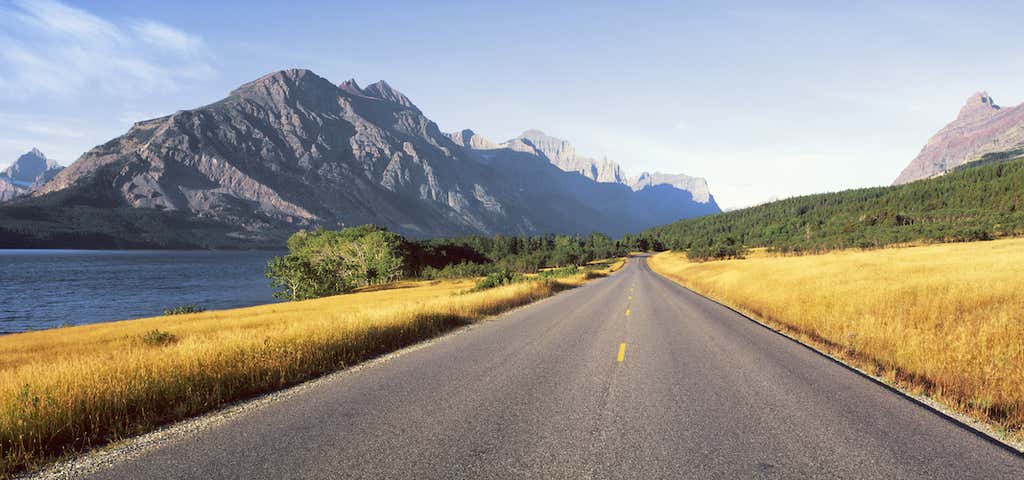
T he Great Northern is a route that features nearly 3,600 miles of mountains, lakes, badlands and valleys. This epic cross-country road trip closely parallels US-2. U.S. Route 2 (also known as U.S. Highway 2) was nicknamed "The Great Northern" in commemoration of the the historic transcontinental railroad that helped pioneer the settlement of the West. Highway 2 is the Northernmost east-west route in the country, and driving it continuously will even take you into Canada! Plus, as one of America's longest transcontinental road trips, you'll enjoy unsurpassed scenery as you journey from coast to coast, bisecting the North American continent, just like Lewis and Clark over a century ago.
Olympic National Park
Port Angeles, WA
Start at the Pacific Ocean to make your Great Northern trip truly cross-country. Besides, the beaches here are utterly breathtaking. The misty waves, the jagged cliffs, and the tidepools filled with enchanting sealife all add to the experience. Plus, Olympic National Park boasts a stunning temperate rainforest that's worth exploring as well.
Click to discover a great deal!
1 Treehouse Point
Seattle has tons of great hotels, but come on, you can't pass up the chance to stay in one of the country's most beautiful treehouse resorts! Treehouse Point in Issaquah, WA is more like camping, since not all of the treehouses are equipped with running water, but it's worth it to sleep in among the branches of one of the Pacific Northwest's many gorgeous forests.
2 Double R Diner (& Twin Peaks Filming Location)
Even if you've never seen Twin Peaks, you'll still fall in love with Twede's Cafe's "damn fine cup of coffee" and incredible cherry pie the way David Lynch (and, of course, Dale Cooper) did from the cult TV show. In fact, the town of North Bend is rustic Pacific Northwest charm at its finest. Plan on spending the day exploring, and visit nearby Snoqualmie Falls.
3 Red Mountain Coffee
Red Mountain Coffee in Snoqualmie Pass is a quaint little coffee shop (Washington is known for their awesome coffee, of course) attached to a historic travelers' stop, so it makes for a nice place to grab a slice of pizza or even just a drink and a snack, and get off the road for a bit.
4 Dick and Janes Art Spot
The Pacific Northwest is also known for their funky arts scene, and Dick and Janes Art Spot is a great example of everyday folk art. The couple has adorned their fences, yard and the exterior of their home with bottle caps, reflectors, and other found objects, turning their house into a work of art! Since it's a private home, be respectful when taking pictures from the side of the road.
5 Cave B Estate Winery
Cave B Estate Winery in Quincy is a great roadside stop to enjoy beautiful scenery and delicious wines, and you can even stay the night. They offer a variety of accommodations, including an inn and yurts, plus a spa and an incredible cliffside swimming pool.
6 Frank's Diner
Frank's Diner in Spokane is located in a train car and is a classic road food stop. Frank's serves up all the staples (burgers, hashbrowns, biscuits), as well as tasty takes on old favorites (hello, Creole seafood omelette!)
Red Wagon - Riverfront Park
Spokane, WA
Riverfront Park is a central feature of Spokane and features tons to see and do. It's got the pavilion, a carousel, an IMAX theater, a small theme park for kids, a skyride over the waterfall, and a massive red wagon, just like the one you probably had as a kid. Great photo op!
8 Ida-Home B&B
Once you've hopped the border from Washington to Idaho, You'll feel right at Ida-Home at the Ida-Home B&B! It's got everything you could want in a bed and breakfast, from hot tubs and campfires to stunning sunsets and spacious, elegant rooms with private bathrooms. Oh, and the gourmet, locally-sourced, organic breakfast you can enjoy on the porch as you wake up in the morning is pretty great, too.
9 Silverwood Theme Park
From twisting roller coasters and gut-wrenching drop rides to bumper cars and train rides, Silverwood Theme Park in Athol, ID is an old-school theme park that definitely brings fun for all ages. Also, they have a waterpark with a lazy river that has a bar right in it!
10 Moose's Saloon
Don't be fooled by the very rustic exterior and sawdust-covered floor of Kalispell's Moose's Saloon. They serve up hot and delicious pizzas, sandwiches, and have tons of craft beer on tap. Plus, if you're traveling with kids, they'll love their talking moose.
11 Swan River Inn
The Swan River Inn in Bigfork, MT is a little hotel with a room for every taste, literally. It features themes like "leather and lace", "exotic Arabian nights", "Tuscan", "French Country", "Geisha", "Art Deco", and "Log Cabin", just to name a few. When you're not basking in the quirky decor of your accommodations, you can enjoy the rooftop garden or walk into the rad town of Bigfork.
12 Montana Vortex & House of Mystery
Mystery Houses are a classic roadside stop, and the Montana Vortex and House of Mystery in Columbia Falls has been bending brains since the 1970's. Once you step inside, forget everything you learned in high school physics, because gravity will appear to stop working, you'll be able to see your aura, and you can soak up the healing energy from the labyrinth.
Glacier National Park
West Glacier, MT
Definitely plan on spending at least a day exploring Glacier National Park. You'll want to drive along the Going-To-The-Sun Road, and take a boat tour on one of the park's stunningly clear glacial lakes at the very least. Plus, be on the lookout for the adorable mountain goats and huckleberries along the way (you can pick up to a quart to carry out for road snacks!)
14 Big Lodge Espresso Tipi
Over in Browning, get ready for another roadside icon. The Big Lodge Espresso Tipi is a coffee shop that doesn't rest on its distinctive digs to bring in customers: it actually makes a mean latte, and is the perfect place to fuel up while spending lots of time on the road.
15 Lewis and Clark National Interpretive Center
Lewis and Clark made a journey that was just as rad as the Great Northern, so stop at the Lewis and Clark National Interpretive Center in Great Falls. This super comprehensive museum will teach you everything about their cross-country excursion. As you travel across the country, learn about what Westward expansion meant to the country, and the struggles of Lewis and Clark's adventure.
16 Eddie's Supper Club & Coffee
When you're hungry, head to Great Falls for some cold drinks, great campfire-style steaks and chops, homemade mint ice cream and other steakhouse classics. Eddie's Supper Club and Coffee serves old-school cuisine in an authentic 1960's atmosphere, which makes this a fun place to stop for dinner or coffee on the road. You might need a nap after digging into their prime rib and shrimp scampi, though.
17 Pheasant Tales Bed & Bistro
Pheasant Tales Bed and Bistro is a casual B&B that mostly caters to those looking for hunting and hiking in Montana, which is a really fun way to experience that side of the state. It's a very relaxed (but still super accommodating) place, and the views from the sun room are just as good as their dinners.
18 War Horse National Wildlife Refuge
If you are looking to do some hunting and fishing (and to maybe have your B&B hosts cook your catches) then War Horse National Wildlife Refuge is the place to do it. It's also an incredible place to enjoy the rugged landscapes of Montana's untouched wild beauty.
19 CC's Family Cafe
Thick, rich milkshakes, triple-decker sandwiches, and awesome classic roadside vibes make CC's Family Cafe the perfect place for breakfast, lunch or dinner.
The best time of year for a Great Northern road trip is late spring, summer and early fall. Since you're traveling along the northern part of the states, weather definitely will play a role in your trip. Also, consider getting a National Park pass if you plan on hitting up several national parks along the way, because it will definitely save you money.
Roadtrippers
Roadtrippers helps you find the most epic destinations and detours—from roadside attractions to natural wonders and beyond.
Explore More Trip Guides
- Route 66 Leg 2: St. Louis to Tulsa
- Route 66 Leg 1: Chicago to St. Louis
- Route 66 Leg 3: Tulsa to Amarillo
Route 66 Leg 4: Amarillo to Albuquerque
Keep exploring with the roadtrippers mobile apps..
Anything you plan or save automagically syncs with the apps, ready for you to hit the road!
Connect with us and hit up #roadtrippers
Tall tales, trip guides, & the world's weird & wonderful.
- Roadpass Digital
- Mobile Apps
Business Tools
- Partnerships
Get Inspired
- Road trip ideas by state
- National parks
- Famous routes
- Voices from the Road
Fresh Guides
- The ultimate guide to Mammoth Cave National Park
- The Ultimate Guide to Badlands National Park
- Top 10 things to do in Ohio
- Offbeat Road Trip Guides
- Road Trip USA
- Scenic Routes America
- National Park Road Trips
- Terms and Conditions
The Trans-America Trail is Where the Adventure Begins

This guide to the Trans-America Trail is brought to you by our friends at Midland USA. Their MicroMobile two-way radios are a favorite among overlanders who depend on reliable communication on and off the trail.
Iconic trails like the Pacific Crest Trail and Appalachian Trail showcase our country’s natural beauty via hiking. Famous roads like Route 66, Pacific Coast Highway, and the Blue Ridge Parkway highlight scenic landscapes via paved highway. But what about those who want to venture off the pavement but stay on wheels?
Enter the Trans-America Trail. The TAT is a 4×4 vehicle route that stretches 5,000 miles across the lower 48 while avoiding paved roads as much as possible. The main travelers of the TAT are dual-sport motorcycle riders and overlanders who average about 200 miles per day winding through beautiful American landscapes from the Atlantic coast to the Pacific.
If you find excitement in the challenges of navigating off the beaten path, then this epic overlanding route might be the adventure you’re looking for.
Make Your Own Adventure Along the Trans-America Trail
The Trans-America Trail was founded by passionate dual-sport motorcycle rider Sam Correro, who spent 12 years working to bring the trail to fruition. Sam wanted to share his passion for off-road exploration.
So in 1984, he set off to create an off-pavement, cross-country trail of epic proportions. Sam’s route uses public roads, almost exclusively. The Trans-America Trail does not cross any private land, therefore your adventure should never be cut short by a locked gate.
Navigating the Trans-America Trail
Sam is passionate about the offroading trail and sharing that joy with others. After 30 years, he still rides the route and updates TAT navigation resources regularly to keep up with any private and public property changes that may affect navigation.
He also makes himself readily available for questions and feedback about the route. He is more than happy to assist you on planning your TAT adventure. Sam has created a route that gets off the pavement but stays close to services, food, and lodging.
His site, TransAMTrack.com , is the exclusive resource for maps, roll-charts, and GPS Tracks – travelers should avoid using other GPS files that may incorrectly lead them through private lands. According to Sam’s website, there are several other sources providing inaccurate (and illegal) trail navigation through private property. Authorities have been made aware and are issuing citations to trespassers, therefore it is vital to only use the official navigation resources provided by Sam on TransAMTrack.com.
Depending on how you choose to experience the TAT, there are several navigation resources available to you including GPS tracks, roll charts, and maps. To keep you safe and your journey fun, Sam recommends using multiple navigation tools and reliable communication like a dash-mounted MicroMobile or handheld two-way radio . Much of the route is out of cell tower range, so drivers will not be able to rely on their cell phones for navigation or communication. If you’re in a pinch you can use the offline maps and campgrounds of The Dyrt PRO to find the free public lands near you.

Sam’s maps provide a 20,000-foot view of the route. His maps include planned stops for food, drink, fuel, maintenance, and lodging options along the trail. Some of these options even include homes, ranches, and businesses that support the adventurous spirit of the TAT and extend friendly hospitality along the route.
Roll Charts
If you are going to embark on the trail with a dual-sport bike, then the TAT roll charts are for you. These rolls of paper, also called route sheets or road books, provide turn by turn instructions. Riders can easily view the next route instruction through a small viewing window of the roll chart holder mounted on the handlebars.
While GPS is not required, and riders can navigate the entire trail with roll charts, it is recommended that you also use GPS.
Want an adventure of your own? Find free camping near you
Did you know that almost all states in the US have free camping?
Although, some of it is not-so-great and can be hard to find.
There is an easier way:
- Hand-picked free campsites
- Pre-saved to your phone
- The best in all 50 states
It’s the only hand-picked list of 5,000 free camping locations that you will find anywhere.
It comes with a bunch of other features like last-minute camping texts, offline maps, etc.
You can check it out for free today by starting a free 7-day trial. After the 7-day trial, the membership is just $35.99 for a full year of access — well worth it if you camp more than 2 times per year.
If you’re tackling the TAT with your overlanding rig, then the GPS tracks along with maps will help navigate you across the country. It should be noted that GPS tracks and GPS routes are not the same thing.
A GPS route is for a series of predefined paths that help you navigate to a specific destination. If you take a wrong turn, the GPS route will recalculate your path based on your current location.
GPS tracks are like breadcrumb trails from previous travelers. Opposed to GPS routes, tracks are when you want to follow a specific path. Unlike the former, if you take a wrong turn, the GPS track will redirect you back to your original path rather than recalculating a new one.
They allow you to recreate the exact path someone else completed before you. Therefore, this is the GPS navigation Sam has provided for the TAT.
Before heading out, we recommend getting yourself familiar with your navigation tools and resources. Learn how to use a compass and take an orienteering class to reduce your chances of getting lost.
Routes of the TAT

Image from TransAMTrack.com
There are four routes of the TAT — the main Trans-America Trail and 3 spur routes. The 3 side routes are the Shadow of the Rockies, the Atlantic Ocean Spur, and the Pacific Ocean spur. The spurs add more overlanding miles and opportunities to explore great American landscapes.
TAT overlanders can choose their starting point anywhere along the route. However, drivers should know that the Trans-America Trail, maps, and roll charts were specifically designed to navigate from East to West.
The routes are both practical and scenic. Sam’s thoughtful planning showcases the beauty of our wildlands while taking the guesswork out of finding a place to rest. This means you can choose to sleep under the stars by camping or you can settle into something a little more comfortable at one of his lodging recommendations.
Unfortunately, Sam’s maps and roll charts do not include campgrounds, state parks, or national parks. Don’t worry though, there are endless camping options along the way.
Find free campgrounds from your car without WiFi. The Dyrt PRO lets you download maps and campgrounds without cell service. “My alternative to using pro would be to drive back out to cell service.”
The Main Route of the Trans-America Trail
The main route of the Trans-America Trail takes in a huge variety of terrain and landscapes. The TAT begins in West Virginia and heads into Georgia before it turns and heads west. Near the Utah-Nevada border the trail goes north towards Idaho and then cuts back east through Wyoming and South Dakota.
The TAT takes drivers through and near many of our great national parks. Here are the National Parks closest to the main route:
- Great Smoky Mountains National Park
- Great Sand Dunes National Park
- Canyonlands National Park
- Arches National Park
- Capitol Reef National Park
- Great Basin National Park
- Yellowstone National Park
- Grand Teton National Park
- Wind Cave National Park
- Badlands National Park
Shadow of the Rockies Spur

Great Sand Dunes National Park // Image from The Dyrt camper Alicia V.
The Shadow of the Rockies spur begins just outside of El Paso, Texas and heads north crossing the TAT at the northern New Mexico border and reconnecting the the TAT at the Wyoming-Colorado border.
It should be no surprise that the Shadow of the Rockies route is a very rocky one. After leaving the popular ghost town of St. Elmo, this spur takes overlanders over the infamous Tin Cup Pass.
This challenging rocky pass is one of the highest mountain roads in Colorado. Riders have the option to skip this section of technical terrain. Sam provided an alternate route to bypass Tin Cup Pass by going through Buena Vista and Cottonwood Pass.
This spur offers travelers the chance to make a side trip to the continental divide and visit Rocky Mountain National Park . Visit the tallest sand dunes in North America and explore the unique terrain of the nearby Great Sand Dunes National Park .
Atlantic Ocean Spur
At 469 miles, the Atlantic Ocean Spur (AOS) is the shortest of the 3 spurs. Riders can ride from Nags Head on the outer banks of the Atlantic through Shenandoah National Park into Burnsville, Virginia.
Due to the densely populated east coast, the first half of this spur is pavement. The second half more than makes up for it with beautiful winding roads through rural countryside and lush forests. Riders are sure to enjoy taking in the rolling mountain views of the Blue Ridge Mountains.
Pacific Ocean Spur

The Oregon Coast at Humbug Mountain State Park near Port Orford // Image from The Dyrt camper Jesse H.
This 800-mile spur takes riders from the TAT all the way to the Pacific Ocean. The side-route leaves the TAT in Emmett, Idaho and takes drivers across Oregon to Port Orford on the coast. This section of trail showcases the lush green beauty of the Pacific Northwest.
Due to the remote nature of much of this section, it is recommended that you monitor your fuel and water carefully. Oregon’s many national forests and public lands offer ample camping opportunities.
This short spur doesn’t get as close to national parks as the other routes. However, if you don’t mind a few more miles behind the wheel you can visit two Pacific Northwest gems — Crater Lake National Park and The Redwoods .
Related Articles:
- Utah Slot Canyons
- Arabia Mountain
- Float Trips in Missouri
- Virginia Creeper Trail
Popular Articles:
- Get the Latest 2023 Camping Travel Trends
- How To Find Free Camping in National Forests
- The Checklist Every First Time RVer Needs
- Find Free Camping With The Dyrt Map Layers
- The Ulimate Boondocking Guide To Free Camping
- Everything You Need To Know About Wifi For Your RV
- 7 of The Best Overland Routes in North America
- 14 Wilderness Survival Tools You Should Have in The Backcountry
- Here's What To Add To Your Primitive Camping Checklist
Kayla is an award-winning outdoor photographer and published author who's enthusiastic about travel and storytelling. She loves to ski and hike, and is alway looking for a new outdoor adventure. She is passionate about increasing women’s participation in the outdoors.
More Articles
The Boondockers Guide to Free Camping Like a PRO
Imagine this: You’ve found the most incredible campsite, with stellar views and access to trails and lakes, and there’s nobody else around. Better yet, it’s…

10 Free Washington Campgrounds, From the Mountains to the Coast
This article on free camping in Washington state is brought to you by Red Ledge. Red Ledge’s rebel windbreaker is made from ripstop nylon and…
- Search Please fill out this field.
- Manage Your Subscription
- Give a Gift Subscription
- Sweepstakes
- Destinations
Best Road Trips for Every Decade of Your Life
Plan your next great American road trip.
Evie Carrick is a writer and editor who’s lived in five countries and visited well over 50. She now splits her time between Colorado and Paris, ensuring she doesn't have to live without skiing or L'As du Fallafel.
:max_bytes(150000):strip_icc():format(webp)/evie-carrick-df91be43396540c492c4141c56a71a9e.jpg "transcontinental road trip")
There's nothing quite like being out on the open road . And as travel slowly returns, planning a truly epic, once-in-a-lifetime road trip may be the perfect reintroduction. As we grow as travelers, our tastes continue to evolve — meaning the road trip that spoke to you as a 20-something might not be right for you in your 40s. So, to get you started on your next great American adventure, we've outlined where to road trip (and what to see along the way) during each decade of your life
The truth is, you'll never outgrow the liberating feeling of packing up the car and taking on the role of the pilot, stopping on a whim or making a detour when something catches your eye. A transcontinental or multi-day road trip isn't just for college grads or retirees, there's a route for travelers in every decade of their life.
Of course, these routes are only meant to get the ball rolling. Like any good road trip pilot, feel free to add in stops and side trips that suit you to create your own personalized version of these epic road trips.
In your 20s: Pacific Coast Highway
Lauren Breedlove/Travel + Leisure
Technically, you can make the coastal drive from northern California to San Diego in around 10 hours, but this is not the sort of road trip you'll want to rush. The Pacific Coast Highway (also known as Highway 1) is one of the most scenic drives in the world, so roll down the windows, enjoy the views, and keep on top of your Instagram story.
The route leads travelers right along the continental United States' westernmost coast, where "pull over the car, we need a photo" sunsets are the norm and castles, sea lions, and pebbly beaches are waiting to be discovered.
For a leisurely road trip, we recommend starting your adventure in Olympia, Washington and ending in San Diego, California , crossing three coastal states along the way. In Olympia, stock up on road trip essentials before heading west until you hit Highway 101 (which eventually leads to California's Highway 1).
Before you reach the Oregon border, swing by Washington's Cape Disappointment State Park . It's a great place to camp (or rent a yurt for the night), but you can also get out and stretch your legs on the 1.2-mile Cape Disappointment Trail or the 0.45-mile Benson Beach Trail. If you're lucky, you may spot an orca in the distance.
In Oregon, swing by the Devil's Punchbowl State Natural Area . During low tide, you can explore the tide pools and pack along a picnic, but you'll want to get to higher ground as the tide comes in and the ocean starts slamming and swirling into the natural carved-out bowl. For great photo ops, head to Cape Perpetua Scenic Area or take a hike and catch the sunset at the Samuel H. Boardman State Scenic Corridor .
When you cross the border into California, it doesn't take long to link up with Highway 1, the official start of the Pacific Coast Highway (or the PCG, for those in the know). Drive through Redwood National and State Parks — home of the tallest trees on Earth — and post up on the black-sand beach in King Range National Conservation Area's Shelter Cove. Further down the road, visit the historic lighthouse in Point Reyes National Seashore before hitting San Francisco's Golden Gate Bridge .
Once you've passed through the city, it won't take long before you hit Big Sur , a 90-mile stretch of dreamy coastlines, dramatic cliffs, and beautiful bridges along winding roads. You'll want to take your time here; highlights include Pfeiffer Beach, McWay Falls, Bixby Creek Bridge, and Pebble Beach. After you've passed Big Sur, stop by the stunning Hearst Castle (which has experienced some pandemic-related closures, so check the website before planning your visit) and Piedras Blancas , where you'll find elephant seals lounging. Make time for a hike in San Luis Obispo or a wine tasting just outside Pismo Beach in Paso Robles before swinging through Santa Barbara for shopping and a visit to the Santa Barbara Botanic Garden .
When you hit Los Angeles, soak up some culture at The Getty or people-watch at Venice Beach before making your way to the road trip's final stop: San Diego. Here, enjoy one final drive to La Jolla Cove Beach or Mission Beach and toast to your completion of the extended Pacific Coast Highway.
In your 30s: The Loneliest Road
Traversing the continental United States — literally from sea to shining sea — is U.S. Route 50, also known as The Loneliest Road . Your trip starts in Sacramento, California and ends in Ocean City, Maryland around 3,200-miles later. Named "The Loneliest Road in America" by Life magazine in 1986, this route takes travelers through tiny towns and sparse, open spaces, providing a peek at what some consider to be the "real America."
Embrace the "lonely" theme and make it a solo mission, or grab a friend and make the trip anything but lonesome. Either way, you're in for a treat. The route passes through a dozen states and landscapes that include the Sierra Nevada, Appalachian, and Rocky Mountains; the Great Plains' open farmlands; and the dry, high deserts of Utah.
From Sacramento, follow the old Pony Express route up into the Sierra Nevadas, where you'll hit the shores of Lake Tahoe. Enjoy a swim, or just take in the view, before hopping back in the car and making your way toward Nevada, on the portion of the road that gave the route its name. After miles and miles of little more than mountains and sagebrush, you'll climb over Utah's Wasatch Front and into red-rock country, home of Moab's Arches National Park and Canyonlands National Park .
Continuing east, head through the Rocky Mountains, crossing over the Continental Divide. Grab a hearty lunch and more road trip provisions in Salida, Colorado before heading into eastern Colorado and the start of the Great Plains, where you'll get a healthy dose of Americana landscapes — small towns, railroad tracks, and water towers.
From here, U.S. Route 50 crosses from Kansas City to St. Louis and traverses the Mississippi River before heading into the agricultural heartlands of Illinois, Indiana, and finally, Ohio. Swing through Hoosier National Forest in Indiana and the college town of Athens, Ohio . In West Virginia, make a point to enjoy the scenic vistas of Monongahela National Forest before hitting Virginia and the bustle of downtown Washington, D.C. After the mayhem of the city, you'll pass through a few fishing and farming communities in rural Maryland, and then arrive in your destination: Ocean City, Maryland.
Once you reach Ocean City, take some time to walk the boardwalk, put your feet in the sand, and reflect — you made it.
In your 40s: Grand Canyon to Yellowstone to Mount Rushmore
This 1,290-mile route takes around 20 hours and includes stops at the Grand Canyon, Yellowstone National Park, and Mount Rushmore. Providing the perfect blend of outdoor activity, family car time, and American history, it makes for the ultimate week-long family road trip .
Your journey kicks off in Flagstaff, Arizona, just over an hour from Grand Canyon National Park's South Rim, which is open year-round. In the park, cruise along Desert View Drive and burn off some energy while climbing the 85 steps to the top of the Desert View Watchtower, where you can enjoy 360-degree views of the canyon.
From here, continue north toward Salt Lake City, Utah. Take a small detour through Park City — for biking, rafting, hiking, and plenty of mountain town charm — before stocking up in Salt Lake City and preparing for the next stretch. If you have time (or need a break from the car), check out the beaches and trails on Antelope Island or visit the Bear River Migratory Bird Refuge north of Ogden, Utah.
From northern Utah, make the long haul through Idaho until you hit the Montana border, where you'll be able to drop into Yellowstone National Park's west entrance near the city of West Yellowstone, Montana — assuming you're visiting between early April and early November, when the road is open to the public . From the west entrance , you can access the Old Faithful geyser in just over an hour, and it's another 40 minutes to Grant Village on beautiful Yellowstone Lake .
When you're back in the town of West Yellowstone, head north toward Bozeman, Montana, a great place to get out, stretch your legs, and do some exploring. From Bozeman, head east toward Billings. Pass through the Crow Reservation before hitting Wyoming's Bighorn National Forest , one of the oldest government-protected forest areas. From here, you'll pass into North Dakota, home of the Black Hills National Forest and Mount Rushmore — your final stop.
In your 50s: The Oregon Trail
Entering your 50s marks a transition — perhaps you have kids who are leaving the nest, or are looking ahead to retirement. It's a shift that warrants plenty of time to reflect and enjoy the beauty of the U.S. And what better way to achieve that than a transcontinental road trip? The Oregon Trail is a beautiful, roughly 2,000-mile route that connects Missouri to Oregon.
Just like the pioneers in the mid-1800s, you can start your expedition in Independence, Missouri, making your way west — although at a much faster pace — toward Oregon. You'll pass through the beautiful, expansive Great Plains before stopping in Sioux City, Iowa to get a dose of culture at the Sioux City Art Center . In Nebraska, make a stop at the Ashfall Fossil Beds State Historical Park , a protected area full of fossils.
Once you pass into Wyoming, you'll slowly head west toward the mountains, home of Grand Teton National Park and the iconic Yellowstone National Park . Depending on the season, you can pick your national park of choice and make the appropriate turn at Shoshoni, Wyoming, heading north toward Yellowstone or south toward the Grand Tetons and Jackson Hole, Wyoming . The two routes link up again in Idaho Falls, Idaho, where you continue west.
In Idaho, don't miss Craters of the Moon National Monument & Preserve , a vast wonderland of solidified lava, and make sure to stock up on road trip essentials and explore Boise, Idaho before crossing into Oregon. Here, you'll pass through the Blue Mountains and Cascade Range before dropping into Portland, and finally, Oregon City. Continue on to Cannon Beach and Ecola State Park if you're ready for some fresh sea air and a taste of the rugged Oregon coastline.
In your 60s: Route 66
The romance of Route 66 is only amplified by driving the aptly named road in your 60s — even better if you happen to be 66. The route runs from Chicago to Los Angeles, passing through the heart of the U.S. and some notorious roadside stops . Jam "Route 66" by the Nat King Cole Trio as you zoom by the best of Americana — from giant neon signs to tiny towns and vacant truck stops.
Before it became the Route 66 we know today, there was the transcontinental National Old Trails Road , and years later, around World War II, it was a main thoroughfare through small towns across the Midwest and Southwest. During the Great Depression, farmers displaced by the Dust Bowl traveled to California along the route. Today, you'll get a taste of Route 66's long history as you pass old-timey diners and motels and plenty of roadside attractions that provide a healthy dose of nostalgia.
Starting in Chicago, head toward Springfield, Illinois, where you can visit the Lincoln Tomb . From here, continue south to Missouri and pick up a refreshing frozen custard at Ted Drewes Frozen Custard in St. Louis. Cruise through the open plains and hills of Oklahoma, making pit stops in Tulsa and Oklahoma City.
As you pass through the northern tip of Texas, drop by Cadillac Ranch , a 1974 public art installation that consists of 10 Cadillacs tilted nose-first in the ground. In New Mexico, make sure to spend some time in Santa Fe , a rich cultural city full of museums, shopping, and amazing food (make sure to try something smothered in green chiles). And if you have time, make a detour to the South Rim of the Grand Canyon National Park as you pass through Flagstaff, Arizona.
Continue on Route 66 to Los Angeles, where you can get your fill of old Hollywood before ending your trip – drink in hand — looking out over the Pacific Ocean.
In your 70s and Beyond: The Atlantic Coast
Your 70s are the perfect decade to hit the road and see the sights. The Atlantic Coast road trip starts in New York City and ends with a tranquil drive across the Overseas Highway to Key West in the Florida Keys — with plenty of coastal wilderness, beautiful beach resorts, and old fishing villages along the way. The trip is just under 2,000 miles and much of it runs along — or near — the Atlantic Ocean.
Start in New York City, where you'll want to spend a day or two checking out the sights — most notably, the Statue of Liberty , Ellis Island, and Times Square. From New York, head south toward Atlantic City, where you can cruise along the boardwalk, grab some food, or try your hand at gambling. Continue south toward Cape May and enjoy the city's Victorian charm before taking a ferry (car included!) to Lewes, Delaware . From Lewes Beach, you'll head into Maryland, swinging through the protected Assateague Island National Seashore. Cruising through states, make a quick stop on Virginia Beach before dipping down to Roanoke Island, North Carolina , where North America's first English-speaking colony mysteriously disappeared in 1587.
While in North Carolina, stop to stretch your legs in downtown Wilmington. For a taste of nostalgia, visit Myrtle Beach, South Carolina, which is home to a boardwalk that's lined with rides and saltwater taffy shops. If you're up for a round of golf, or some more beach time, head to Hilton Head Island , then drop down to Savannah, Georgia.
Once you cross the border into Florida, make time to visit the beautiful Cocoa Beach and grab a Cuban sandwich in Miami before heading farther south into the Florida Keys.

Are you ready for a Road Trip? Explore these eleven incredible cross-country road trip routes across the U.S.!
Pacific Coast
Border to Border
The Road to Nowhere
The Great River Road
Appalachian Trail
Atlantic Coast
The Great Northern
The Oregon Trail
The Loneliest Road
Southern Pacific
Home / The Great Northern

The Great Northern Road Trip: US Highway 2
Though many come close, no other cross-country route takes in the variety and extremity of landscape that US Highway 2 does. Dubbed the Great Northern in memory of the pioneer railroad that parallels the western half of the route, US-2 is truly the most stunning and unforgettable, not to mention longest, of all the great transcontinental road trips.

Starting in the west near the beautiful Pacific port city of Seattle, US-2 runs steeply up and over the volcanic Cascade Range, climbing from sea level to alpine splendor in around an hour. From the crest, the road drops down onto the otherworldly Columbia Plateau, a naturally arid region reclaimed from sagebrush into fertile farmland by New Deal public works projects like the great Grand Coulee Dam, one of the largest pieces of civil engineering on the planet. From Washington, US-2 bends north, clipping across the top of the Idaho Panhandle before climbing into western Montana, a land of forests, rivers, and wildlife that culminates in the bold granite spectacle of Glacier National Park.

On the eastern flank of the Rockies, the route drops suddenly to the windswept prairies of the northern Great Plains. Though empty to look at—especially when you’re midway along the 1,000-mile beeline across Montana and North Dakota, wondering how long it will be until you see the next tree or peak—this is a land rich in history, where the buffalo once roamed freely, where Plains peoples like the Shoshone, Blackfeet, Sioux, and Cheyenne reigned supreme, and where the Lewis and Clark expedition followed the Missouri River upstream in search of a way west to the Pacific.
Midway across the continent, the Great Plains give way to the Great Northwoods country of Minnesota —birthplace of both Paul Bunyan and Judy Garland—and then to the rugged lumber and mining country of Wisconsin and Michigan’s Upper Peninsula. Continuing due east, the route crosses the border into Ontario, Canada, running through the francophone environs of Montreal before returning to the United States near lovely Lake Champlain in upstate New York.

From there, US-2 passes through the hardwood forests of Vermont’s Green Mountains and the rugged granite peaks of New Hampshire’s White Mountains, two very different ranges, though only 50 mi (81 km) apart. The route winds down to the coast of Maine, reaching the Atlantic Ocean at Bar Harbor and Acadia National Park.
Landscapes, rather than cities and towns, play the starring roles on this route. After a few days spent following US-2 through small towns and wide-open spaces, you’ll probably consider Duluth bustling and fast-paced; driving even a short stretch of the Great Northern highway is guaranteed to bring new meaning to the expression “getting away from it all.”
Sights along a US Highway 2 Road Trip
For more insight into each stop along the Great Northern road trip, our content is arranged by state. Here are some major sights along US Highway 2 where travelers aiming to follow only a section of the full cross-country route may wish to use to plan their drive:
- Seattle, Washington – An engaging and energetic combination of scenic beauty, blue-collar grit, and high-tech panache
- Glacier National Park, Montana – Offering incredible scenic beauty and innumerable options for outdoor recreation
- Devils Lake, North Dakota – Home to historic Fort Totten, one of the country’s best-preserved 19th-century military forts
- Duluth, Minnesota – One of the most beautiful and underappreciated travel destinations in the Midwest
- Apostle Islands National Lakeshore, Wisconsin – Take a detour on our favorite summer drive and follow Highway 13 along the picturesque shore of Lake Superior
- Mackinac Island, Michigan – No cars allowed! Park your ride and ferry over to one of the top draws in the Midwest
- Ottawa, Ontario – Canada’s national capital is one of the most peaceable and pleasant of the world’s capitals
- Montreal, Quebec – Charming and cosmopolitan, Montreal is easily the most European city in North America
- Burlington, Vermont – Best known these days as the home of Senator Bernie Sanders and countercultural icons Ben & Jerry’s
- Jefferson, New Hampshire – Featuring one of the state’s biggest tourist draws: Santa’s Village
- Acadia National Park – Explore the natural glory of Mount Desert Island and be sure to get out of the car and head inland on foot on the park’s many hiking trails
Related Travel Guides

- Barnes & Noble
- Books-A-Million
- Indigo (Canada)
- Powell's Books
- Apple Books

Great Northern Route Travel Maps

Pin it for Later

February 20th, 2023 • 5 min
The Great Northern: An Epic Cross-Country Trip

Highway 2 is the Northernmost east-west route in the country, and driving it continuously will even take you into Canada! Plus, as one of America’s longest transcontinental road trips, you’ll enjoy unsurpassed scenery as you journey from coast to coast, bisecting the North American continent, just like Lewis and Clark over a century ago.
Olympic National Park

Source: Shutterstock
Start at the Pacific Ocean to make your Great Northern trip truly cross-country. Besides, the beaches here are utterly breathtaking. The misty waves, the jagged cliffs, and the tide pools filled with enchanting sea life all add to the experience. Plus, Olympic National Park boasts a stunning temperate rainforest that’s worth exploring as well.
Treehouse Point
Seattle has tons of great hotels, but come on, you can’t pass up the chance to stay in one of the country’s most beautiful treehouse resorts! Treehouse Point in Issaquah, WA is more like camping, since not all of the treehouses are equipped with running water, but it’s worth it to sleep in among the branches of one of the Pacific Northwest’s many gorgeous forests.
Double R Diner (& Twin Peaks Filming Location)
Even if you’ve never seen Twin Peaks, you’ll still fall in love with Twede’s Cafe’s “damn fine cup of coffee” and incredible cherry pie the way David Lynch (and, of course, Dale Cooper) did from the cult TV show. In fact, the town of North Bend is rustic Pacific Northwest charm at its finest. Plan on spending the day exploring, and visit nearby Snoqualmie Falls.
Red Mountain Coffee
Red Mountain Coffee in Snoqualmie Pass is a quaint little coffee shop (Washington is known for their awesome coffee, of course) attached to a historic travelers’ stop, so it makes for a nice place to grab a slice of pizza or even just a drink and a snack, and get off the road for a bit.
Dick and Janes Art Spot
The Pacific Northwest is also known for their funky arts scene, and Dick and Janes Art Spot is a great example of everyday folk art. The couple has adorned their fences, yard and the exterior of their home with bottle caps, reflectors, and other found objects, turning their house into a work of art! Since it’s a private home, be respectful when taking pictures from the side of the road.
Frank’s Diner
Frank’s Diner in Spokane is situated in a train car and is a classic road food stop. Frank’s serves up all the staples (burgers, hash browns, biscuits), as well as tasty takes on old favorites (hello, Creole seafood omelets!)
Red Wagon – Riverfront Park
Riverfront Park is a central feature of Spokane and features tons to see and do. It’s got the pavilion, a carousel, an IMAX theater, a small theme park for kids, a sky ride over the waterfall, and a massive red wagon, just like the one you probably had as a kid. Great photo op!
Ida-Home B&B
Once you’ve hopped the border from Washington to Idaho, you’ll feel right at Ida-Home at the Ida-Home B&B! It’s got everything you could want in a bed and breakfast, from hot tubs and campfires to stunning sunsets and spacious, elegant rooms with private bathrooms. Oh, and the gourmet, locally-sourced, organic breakfast you can enjoy on the porch as you wake up in the morning is pretty great, too.
Silverwood Theme Park
From twisting roller coasters and gut-wrenching drop rides to bumper cars and train rides, Silverwood Theme Park in Athol, ID is an old-school theme park that definitely brings fun for all ages.
Moose’s Saloon
Don’t be fooled by the *very* rustic exterior and sawdust-covered floor of Kalispell’s Moose’s Saloon. They serve up hot and delicious pizzas and sandwiches. Plus, if you’re traveling with kids, they’ll love their talking moose.
Swan River Inn
The Swan River Inn in Bigfork, MT is a little hotel with a room for every taste, literally. It features themes like “leather and lace”, “exotic Arabian nights”, “Tuscan”, “French Country”, “Geisha”, “Art Deco”, and “Log Cabin”, just to name a few. When you’re not basking in the quirky decor of your accommodations, you can enjoy the rooftop garden or walk into the rad town of Bigfork.
Montana Vortex & House of Mystery
Mystery Houses are a classic roadside stop, and the Montana Vortex and House of Mystery in Columbia Falls has been bending brains since the 1970’s. Once you step inside, forget everything you learned in high school physics, because gravity will appear to stop working, you’ll be able to see your aura, and you can soak up the healing energy from the labyrinth.
Glacier National Park
Definitely plan on spending at least a day exploring Glacier National Park. You’ll want to drive along the Going-To-The-Sun Road, and take a boat tour on one of the park’s stunningly clear glacial lakes at the very least. Plus, be on the lookout for the adorable mountain goats and huckleberries along the way (you can pick up to a quart to carry out for road snacks!)
Big Lodge Espresso Tipi
Over in Browning, get ready for another roadside icon. The Big Lodge Espresso Tipi is a coffee shop that doesn’t rest on its distinctive digs to bring in customers: it actually makes a mean latte, and is the perfect place to fuel up while spending lots of time on the road.
Lewis and Clark National Interpretive Center
Lewis and Clark made a journey that was just as rad as the Great Northern, so stop at the Lewis and Clark National Interpretive Center in Great Falls. This super comprehensive museum will teach you everything about their cross-country excursion. As you travel across the country, learn about what Westward expansion meant to the country, and the struggles of Lewis and Clark’s adventure.
Eddie’s Supper Club & Coffee
When you’re hungry, head to Great Falls for some cold drinks, great campfire-style steaks and chops, homemade mint ice cream and other steakhouse classics. Eddie’s Supper Club and Coffee serves old-school cuisine in an authentic 1960’s atmosphere, which makes this a fun place to stop for dinner or coffee on the road. You might need a nap after digging into their prime rib and shrimp scampi, though.
Pheasant Tales Bed & Bistro
Pheasant Tales Bed and Bistro is a casual B&B that mostly caters to those looking for hunting and hiking in Montana, which is a really fun way to experience that side of the state. It’s a very relaxed (but still super accommodating) place, and the views from the sun room are just as good as their dinners.
War Horse National Wildlife Refuge
If you are looking to do some hunting and fishing (and to maybe have your B&B hosts cook your catches) then War Horse National Wildlife Refuge is the place to do it. It’s also an incredible place to enjoy the rugged landscapes of Montana’s untouched wild beauty.
CC’s Family Cafe
Thick, rich milkshakes, triple-decker sandwiches, and awesome classic roadside vibes make CC’s Family Cafe the perfect place for breakfast, lunch or dinner.
Theodore Roosevelt National Park
Teddy Roosevelt was famously into conservation and creating National Parks, so stop by Theodore Roosevelt National Park, which preserves some of North Dakota’s most gorgeous badlands and pay tribute to him. Prairie dogs, Teddy’s old cabin, and great stargazing can also be found here.
Rough Riders Hotel
Keep the Theodore Roosevelt theme going with a stay at Medora, North Dakota’s Rough Riders Hotel. The 19th-century building and Western decor add an authentic charm, but it’s still got TVs and Wi-Fi. Plus, the price is super reasonable.
Former Governors’ Mansion
State governors lived in the Former Governors’ Mansion in Bismarck, ND, from 1893 until the 1960’s, but it’s been painstakingly restored to look as it did during the 19th century. Not only does the mansion give you a cool look into the past, but it also shows you how they went about bringing it back to its opulent 1800’s roots.
Space Aliens Grill & Bar
For an offbeat place to fill up on food, head to the Space Aliens Grill and Bar. This quirky regional chain makes some out-of-this-world grub in a spectacularly kooky environment. Definitely a fun place for kids and adults alike.
Frontier Village & National Buffalo Museum
It’s hard to believe that the prairies along the Great Northern route used to be filled with roaming bison. Learn about these endangered beasts and about the Plains Indians, who relied on them for so much, at the Frontier Village and National Buffalo Museum’s interpretive center.
Fargo Movie Wood chipper
If you’ve ever seen the movie “Fargo,” then you’ll want to stop by the Fargo-Moorhead Visitor Center to see the film’s most notorious prop…the wood chipper. They also have copies of the script inside, and there’s even a replica of the wood chipper outside in case you stop by when they’re closed.
Hotel Donaldson
While in Fargo, rest your weary head at Hotel Donaldson. This place is so cool, you’ll forget that you’re not in New York or Chicago. Each suite was decorated by a different local artist, there’s a rooftop bar, and complimentary artisan pastries are included with your room.
Paul Bunyan Land
Next up, Minnesota! People can’t really agree on where America’s most famous tall tale character was born, but some claim he hails from the small town of Brainerd. Hit up Paul Bunyan Land off State Highway 18, where you’ll find rides, a petting zoo, a pioneer village of sorts, and more. It’s definitely got that nostalgic atmosphere, so stop by and poke around.
Nordic Inn Medieval B&B
Minnesota has a strong Nordic heritage, but only one B&B lets you literally become a Viking for a night. No, I’m not kidding: when you stay the night at the Nordic Inn Medieval B&B in Crosby, you get a Viking costume and must create a character to role-play as during the dinner feast. And if history isn’t quite your thing, don’t worry: they have a Minnesota Vikings themed room, too.
Great Lakes Aquarium
You’re on the Great Lakes, so why not check out some of the unique marine life of the region? Learn about shipwrecks, otters, birds, and tons more at the Great Lakes Aquarium in Duluth. You can easily spend several hours exploring here.
Lake Superior Maritime Visitor Center
Equally as important as the creatures that live in the lakes is the maritime history of humans exploring them, and you can learn all about that at the Lake Superior Maritime Visitor Center. From model ships and rooms created to feel like the interior of a boat to views of the lake, perfect for watching ships, it’s educational and entertaining. And the best part? It’s free to visit!
Barnes Trading Post Wilderness Inn
The rustic, woodsy-themed Barnes Trading Post Wilderness Inn is simple, but super cozy. Log furniture, a secluded location, good amenities, and an on-site restaurant make this a peaceful place to rest for the night.
Sidnaw Eats
Sidnaw Eats prides itself on its casual and tasty food served to you by incredibly friendly locals! Grab some coffee and pie here for the road.
Canyon Falls Roadside Park
If you need to stretch your legs, Canyon Falls Roadside Park in L’Anse, MI is an easy, 20-minute-or-so hike. The trail takes you through mossy canyons to a lovely waterfall, which makes it a super rejuvenating way to take a break from driving.
Da Yoopers Tourist Trap
We love roadside kitsch, and the self-proclaimed Da Yoopers Tourist Trap off Highway 41 definitely fits the bill. Cheesy and tacky but still amusing, it’s free to walk around this joint dedicated to Michigan’s U.P. (Upper Peninsula), and browse their silly gift shop.
Blueberry Ridge B&B
You’ll feel like family at the quaint Blueberry Ridge B&B. The hostesses are sweet and incredibly caring, and if you’re lucky, you’ll get a fresh glass of rhubarb juice when you arrive, and some of their amazing blueberry buckle for the road.
Lakenenland Sculpture Park
Lakenenland Sculpture Park in Marquette, MI is free and open 24 hours. This wonderland filled with whimsical sculptures by a local welder is absolutely enchanting. You can fish in the pond, cook s’mores over the fire, or enjoy the live music they have on occasion.
Pictured Rocks National Lakeshore
Next up is Pictured Rocks National Lakeshore. Along this gorgeous lakeshore, you’ll find sand dunes, caves, waterfalls, and more. Whether you’re exploring on foot or on a kayak, you won’t find a more memorable lake landscape.
Upper Tahquamenon Falls
Michigan boasts tons of awesome waterfalls, and the Upper Tahquamenon Falls are no exception. This park has inspired tons of people too, from poet Henry Wadsworth Longfellow to hipster singer Sufjan Stevens.
Roxane’s Smokehouse Restaurant
When you’re ready for a bite to eat hit up Roxane’s Smokehouse Restaurant. Don’t stress yourself out trying to decide which of the smoked meats to order off the menu: split the combo platter and enjoy it all. Or, if you’re a breakfast-all-day kinda person, the smoked brisket omelet is a revelation. Top if off with a slice of classic banana cream pie!
Museum Ship Valley Camp
The Museum Ship Valley Camp in Sault Ste. Marie is an old Great Lakes freighter that’s been turned into a massive museum with over 100 exhibits! There’s also an observation tower where you can take in the views of the bustling shipping channel. What better way to learn about the history of Sault Ste. Marie than here?
Sturgeon River Inn
The Sturgeon River Inn is a comfortable and affordable place to spend the night. They have an on-site restaurant and bar, and the whole place overlooks the lovely Sturgeon River.
Ottawa Jail Hostel
Normally, you want to avoid spending the night in the slammer, but the Ottawa Jail Hostel is just too cool to pass up. Sleep in a bunk bed in a jail cell, enjoy the mug shot decor, and have fun!
Canada Aviation and Space Museum
Canada has a fascinating history with space and aviation that doesn’t often get the attention it deserves. A guided tour of the massive Canada Aviation and Space Museum is the perfect way to brush up on the coolest parts of Canadian aviation.
Montreal Botanical Garden
The Montreal Botanical Garden is huge, and literally every square inch is gorgeous. From the Rose Garden to the Chinese and Japanese Gardens to the arboretum and the collection of rare orchids, you’ll find yourself in pure, natural bliss. Plus, you can visit the always-interesting Insectarium, and the garden is close to the Olympic Stadium as well.
Fairmount Bagels
Amazing bagels outside New York? It’s true, they exist! Whether you want one plain, with a healthy schmear of cream cheese, or topped with lox, you’ll want to grab a few for snacks later on from Fairmount Bagels.
Notre-Dame Basilica of Montreal
The Notre-Dame Basilica of Montreal is a replica of the Notre Dame in Paris, and is the perfect way to learn about Montreal’s French history. Note that the stained-glass windows on this basilica actually depict scenes from the religious history of Montreal instead of Biblical scenes!
Monadnock Bed & Breakfast
There’s nothing we love more than exploring quaint small towns, and staying at the Monadnock B&B is the perfect home base for checking out Colebrook, NH.
World Traveler Sign
Stop by Lynchville, ME’s World Traveler Sign! It’s a quick little photo op to remind you of how far you’ve come…and how much of the world there is left to see!
The Northeast is dotted with classic diners, each more delicious and friendly than the next. The A1 Diner in Gardiner, ME, is a chrome car that adds authentic 1940’s vibes that you can enjoy while you eat your All-American food. Try the grilled blueberry muffin… you are in Maine, after all!
Stephen King’s House
Next up, Bangor, ME! This town is the setting for many Stephen King novels, and it’s also where the horror writer lives. You can’t go inside his house or anything (seriously, don’t trespass), but driving past his gorgeous home will give you a pretty good idea of where he gets inspiration.
Asticou Inn
The vintage atmosphere and picture-perfect views of Asticou Inn really add to the experience of staying at this historic hotel; it’s right by Acadia National Park, which was once a vacation destination for the rich and fabulous during the late 19th and early 20th centuries. Definitely make sure to enjoy popovers and tea on the porch.
Acadia National Park
Finally! You’ve reached the Atlantic Ocean…so take in the very best views the East Coast has to offer at Acadia National Park. The misty cliffs, picturesque lighthouses, and breathtaking hikes are all worth checking out!
The best time of year for a Great Northern road trip is late spring, summer and early fall. Since you’re traveling along the northern part of the states, weather will play a role in your trip. Also, consider getting a National Park pass if you plan on hitting up several national parks along the way, because it will definitely save you money.
Did you make this long cross-country trip, or experience stretches of it? Share your favorite parts of the ultimate road trip with us on Instagram .
Where do you want to go today?
Related articles, road trip along the oregon trail: a journey through history.
Discover the inspiring (and grueling) history of the Oregon Trail with your very own road trip along the infamous route.
Boston to Seattle: Must-see stops on an I-90 road trip
Stretching from Boston to Seattle, Interstate-90 (I-90) is a great choice for a coast-to-coast road trip. Covering over 3,000 miles and 13 major states, there’s plenty to see and do. From beautiful landscapes to iconic cities and national parks, get ready for the ultimate adventure.
Discover American Civil War history in Gettysburg, Pennsylvania
Gettysburg Pennsylvania is famed for its role in the Civil War. Filled with historical sites, it’s the perfect place for a road trip. Plan yours today.
Breaking News Hub: Stay Up-to-Date with the Latest Headlines and Top Stories

Route 50 Road Trip Map: The Ultimate Guide to an Epic Adventure
Embark on the ultimate cross-country adventure with our route 50 road trip map guide! Discover hidden gems and iconic landmarks along the “Loneliest Road in America.
Are you up for an epic road trip adventure that you’ll remember for a lifetime? Look no further than Route 50, a legendary cross-country highway that stretches over 3,000 miles from coast to coast. This ultimate road trip map takes you through 12 states, from the Pacific Ocean in California to the Atlantic Ocean in Maryland.
Route 50, known as the “Loneliest Road in America,” has a rich history that dates back to 1926. It winds its way through the heart of the United States, showcasing diverse landscapes that range from the magnificent Sierra Nevada mountains to the rugged deserts of Nevada, the rolling hills of the Midwest, and the lush forests of the Appalachian Mountains.
Unlike other popular roads, Route 50 offers a unique experience with its lack of big cities and tourist traps. Instead, you’ll discover charming small towns, historic landmarks, and hidden natural wonders that are off the beaten path. This road trip map is perfect for those seeking an escape from the crowds and a chance to immerse themselves in the beauty of America’s heartland.
But Route 50 is not just about breathtaking views and picturesque landscapes. It also holds a significant place in American history as a major route for settlers and explorers during the westward expansion of the country. You can explore historic sites like the Pony Express Trail, which once carried mail from Missouri to California in the mid-1800s, or visit the Lincoln Highway, the first transcontinental highway in the United States.
Whether you’re a history aficionado, a nature lover, or simply in search of a unique adventure, Route 50 has something for everyone. So, grab your map, pack your bags, and get ready for an epic road trip across America’s heartland.
Planning Your Route 50 Road Trip

Before embarking on your Route 50 road trip, it’s essential to plan ahead to ensure a smooth and enjoyable journey. Consider the following factors when planning your trip:
- Timeframe : Route 50 is a long highway, so decide how much time you want to spend on the road. Will you complete the entire route in one go or break it up into smaller segments?
- Season : The weather conditions along Route 50 can vary greatly depending on the time of year. Check the forecast and plan accordingly.
- Budget : Road trips can be costly, so it’s important to set a budget and stick to it. Consider expenses such as gas, food, lodging, and attractions when planning your trip.
- Mode of Transportation : Will you be driving your own car, renting one, or using public transportation? Ensure your vehicle is reliable and well-maintained before hitting the road.
Fortunately, there are numerous tools and resources available to help you plan your Route 50 road trip. Online mapping tools can assist in creating a route, finding hotels, and locating attractions. Additionally, travel apps like Roadtrippers provide valuable information on road conditions, gas prices, and local events. Remember to keep your itinerary flexible, as unexpected adventures and detours often make road trips even more memorable.
Must-See Attractions Along Route 50

Route 50 is teeming with must-see attractions and landmarks that are worth a stop on your road trip. Here are some of the top attractions along the way:
- Great Basin National Park : Located in Nevada, this national park showcases stunning mountain vistas, underground caves, and unique wildlife.
- Gateway Arch : A St. Louis landmark, the Gateway Arch is a 630-foot stainless steel structure that offers panoramic views of the Mississippi River and the city skyline.
- Shenandoah National Park : Located in Virginia, this park boasts breathtaking views of the Blue Ridge Mountains, hiking trails, and the opportunity to spot wildlife like black bears and white-tailed deer.
- Blackwater Falls State Park : Situated in West Virginia, this park features a magnificent 62-foot waterfall, hiking trails, and opportunities for fishing and kayaking.
- Antietam National Battlefield : This Maryland battlefield was the site of the bloodiest one-day battle in American history. Visitors can embark on guided tours, explore historic landmarks, and delve into the depths of Civil War history.
In addition to these top attractions, Route 50 caters to outdoor enthusiasts with activities like hiking, camping, and kayaking. Along the way, explore charming small towns and savor the local cuisine at delightful restaurants to truly immerse yourself in the culture of each place. Don’t forget to plan your food and lodging stops to make the most of your road trip experience.
Tips for a Thrilling Route 50 Road Trip

Before embarking on your Route 50 road trip, keep a few things in mind to ensure a safe and enjoyable journey.
Safety Precautions to Take
Safety should always be your top priority when driving on Route 50. Here are some tips to keep in mind:
- Always wear your seat belt and ensure that all passengers do the same.
- Obey traffic laws and adhere to speed limits.
- Stay vigilant for wildlife on the road, especially at night.
- Maintain a safe distance from other vehicles, particularly large trucks.
- Have your car thoroughly checked and serviced before the trip.
Weather Considerations
Weather conditions along Route 50 can vary significantly, so it’s crucial to be prepared. Keep the following tips in mind:
- Check the weather forecast before you depart and plan accordingly.
- Pack clothing suitable for various weather conditions, including rain gear and warm layers.
- Stay informed about severe weather alerts and adjust your plans if necessary.
- If traveling during winter, equip your vehicle with snow tires or chains and carry essential items like a shovel and ice scraper.
Packing Essentials for the Trip
Packing for a road trip can be a challenge, but here are some essentials to consider for your Route 50 adventure:
- Maps and a GPS device to help navigate the route.
- Snacks and water to keep you fueled during the journey.
- A well-stocked first aid kit and any necessary medications.
- Blankets, pillows, and other comfort items for long drives.
- A camera and binoculars to capture the stunning scenery along the way.

Embarking on a Route 50 road trip is an experience that will leave an indelible mark on your memory. The beauty and history of this iconic highway make it a must-visit for any travel enthusiast. However, like any adventure, proper planning and preparation are crucial. By following the tips outlined in this guide, you can ensure a safe and enjoyable journey across America’s heartland.
So, what are you waiting for? Pack your bags, grab your map, and hit the road on your very own Route 50 adventure. The team at TooLacks wishes you a safe and unforgettable journey!
To learn more about TooLacks and discover other exciting adventures, visit TooLacks .
You May Like

Tashirojima: Japan’s Enchanting Cat Island

U.S. Highway 50: Exploring America’s Historic and Scenic Route

The Loneliest Highway in Nevada: A Guide to Traveling through Desolation
100-year-old Lincoln Highway offers 'magic of the road'

KEARNEY, Neb. — Not everyone back home in Russia — or here in the USA, for that matter — understands the desire of Yuri Pogorely and his brother, Alexy, to drive across America on the back roads.
But here they are in the lobby of a Holiday Inn in Kearney, Neb., at the midpoint on their New York-to-San Francisco tour, and fresh off a parade that had them cruising down Central Avenue in a rented 2013 Mustang.
"People say, 'You're going across Nebraska? Why are you so happy?'" says Yuri, a journalist in Moscow. "But every day something happens that's so interesting. In these small towns, we are an event. And it's an event for us."
It's also an event for 272 participants in 140 vehicles taking part in two auto tours — one that departed New York on June 22 and the other from San Francisco on June 23. The trips were organized to commemorate the 100th anniversary of the Lincoln Highway, the nation's first truly transcontinental road. The west- and east-bound groups met up in this town of 30,000 on Sunday and cruised down its main street, whose original brick paving echoes that of early Lincoln Highway segments.
The tour, organized by the Lincoln Highway Association (LHA), has attracted a mix of history buffs, vintage-car enthusiasts and those who simply enjoy a good road trip and figure the 100th birthday of an iconic route is a good excuse to hit the highway.
"I wouldn't trade this journey for anything," says Lorrie Fleming, 62, of 70 Mile House, B.C. "You're in control of your destiny when you're on the road."
She and her husband, Bob, are nearing the end of a 10,000-mile road trip, which includes the New York-to-Kearney segment with the LHA auto tour. "We could fly to Paris for dinner," she says, noting that her husband is retired from Air Canada and gets free air passes. "But what do we do? Go on road trips. It's the magic of the road."
'America's Main Street'
The Flemings are dining under the portico where gas pumps once stood outside the Shady Bend restaurant in Grand Island, Neb. The establishment has been a fixture on the Lincoln Highway since current owner Craig Woodward's grandfather took a road trip to Arizona in the 1920s. Inspired by the truly horrible conditions endured by early auto travelers, he returned and opened a tourist camp, as it was known in the day.
The cabins are gone, as are the tennis court and buffalo herd corralled to lure passersby. But the old gas station/grocery store has found new life as a restaurant. And some regulars, like Earl Boersen, 83, have been coming here for decades.
"This was my favorite hangout and it still is," he says, taking a seat at a counter with a plaque bearing his name.
Indeed, there's a timelessness along stretches of the Lincoln Highway. Its original 3,389 miles, as conceived in 1913, cut through 13 states. Subsequent realignments shortened the route, taking it into a 14th state and 700 communities, most of them small, some now long forgotten.
When the road came into existence, long-distance travel was mostly via rail. Paved roads existed only in cities and towns, and auto travel on rutted, unpaved byways was not for the faint of heart. A Lincoln Highway Association, spearheaded by Indianapolis Motor Speedway owner Carl Fisher, was formed with the aim of establishing a cross-country rock or gravel route. Others with vested interests, including Henry B. Joy, president of the Packard Motor Co., joined the effort.
"It was America's Main Street, connecting towns and rural areas," says Gary Roubicek, director of the Great Platte River Road Archway, a historical attraction in Kearney. "If you wanted to see America, you could see a good chunk of it on the Lincoln Highway."
Billboards galore
You still can, though after the numbered highway system was established in 1926, the name gradually slipped into obscurity, as did the much-realigned and bypassed original route.
"In its day, it was an advertising bonanza," says Brian Butko, author of two books on the route. "There were songs, sheet music, tires and cigars named after it. Emily Post and Upton Sinclair wrote about it.
"But the road was constantly being bypassed. In 1915, every town wanted the Lincoln Highway to go through. Ten years later, no one wanted it because it bogged things down."
Butko figures about 80% of the original road is still drivable. (The LHA maintains a detailed, interactive map on its website, Lincolnhighwayassoc.org .) It includes most of U.S. 30 in the east, parts of Interstate 80 and much of U.S. 50 in Nevada and California.
Besides the tours organized by the LHA, a group dedicated to preserving and promoting the road, a Norwegian car club, a group of deaf motorcyclists and the Tin Can Tourists, a group of classic trailer aficionados, along with myriad classic-car clubs plan to trace all or parts of the route this summer.
Paul Gilger, chairman of the LHA's mapping committee, hopes the interest surrounding the centennial will help fuel a "slow travel" movement.
"People rush to get to a destination — how many times do you go on vacation and come back exhausted?" he says. "But it's not the destination that's important. It's what happens in between."
To that end, "the Lincoln Highway was more than just a road," he continues. "It was an inspiration and it can still inspire. It makes you realize we're much more than bicoastal. Every place across the country has beauty, and first and foremost, it's in the people."
Half way into their journey across America, the Pogorely brothers have discovered that, too.
"It is like a poster," Alexy says.
"You see the houses and the nice cars outside and the cultivated fields," Yuri adds. "And you realize this is where (a lot of) Americans live. This is what these people are doing. This is why America is so wealthy."
Don't have time to drive the entire Lincoln Highway? Brian Butko, author of Greetings from the Lincoln Highway and Lincoln Highway Companion outlines four routes ranging from 170 to 250 miles with plenty of eye-catching sights along the way.
Driving the Lincoln Highway westbound is to watch the geography of America unfold. Here are four drives that capture the essence of the changing land:
York, Pa. to Latrobe, Pa.: 170 miles
Central Pennsylvania offers a great mix of roadside attractions and rural pleasures. Starting in York, you pass an original 1950s diner and old motels on the way to Gettysburg, site of the best-known Civil War battlefield. To the west is Mister Ed's Elephant Museum in the middle of a state forest, then it's up, down, and over the Allegheny Mountains through Breezewood to Bedford. Look for an ice cream-shaped dairy stand, a restored coffee-pot cafe, and Dunkle's Gulf, an art deco station where the same family has pumped your gas since the 1930s. Stay at the Lincoln Motor Court's tourist cabins, then stop for pictures at wonderful murals painted on barns. The artwork is sponsored by the Lincoln Highway Heritage Corridor. You'll find their little museum farther west in Ligonier near the town square.
DeKalb, Ill. To Belle Plaine, Iowa: 200 miles
West of Chicago, towns and farms spread out across the prairies. Start at DeKalb's beautiful Egyptian Theatre, visit a restored gas station/Lincoln Highway visitors center in Rochelle. Visit the Lincoln Highway Association gift shop in Franklin Grove, see an early Lincoln statue and President Reagan's boyhood home in Dixon, then tour a new windmill overlooking the Mississippi River in Fulton. US 30 is often the Lincoln Highway, but cross into Iowa via IL 136 to be closer to the original route. In Clinton, browse the historic Smith Brothers General Store. Heading west, follow the old Lincoln through small towns like DeWitt, Grand Mound, and Clarence. After Cedar Rapids, get pie at the restored Youngville Station but save room for dinner at the Lincoln Cafe in Belle Plaine. End at Preston's Station, a shrine to early gasoline and oil advertising.
Wyoming-Colorado border to Rawlins Wyo.: 180 miles
Start at the Terry Bison Ranch south of Cheyenne, where you can camp or stay in a cabin, ride horses, and ride on a mini-train amid a bison herd, camels, llamas and emus. In Cheyenne, outfit yourself in cowboy gear, then head west to the highest point on the Lincoln Highway at Sherman Summit, where a pyramid towers nearby and a rest area on I-80 has monuments to Lincoln and a founder of the Lincoln Highway. At Laramie, visit an 1870s prison, then leave I-80 behind and enter the real West as you head north to Rock River and Como Bluff, where lots of dinosaur skeletons have been unearthed. At Medicine Bow, the Virginian Hotel (named for the Owen Wister novel) has changed little in 102 years. You're only halfway back to the Interstate so enjoy the high lonely plains (and occasional cloudbursts) through Hanna, Coyote Springs, and Fort Steele on the way to Rawlins, where you can tour another ancient prison or wait for the Grand Encampment Cowboy Gathering each July.
Tooele, Utah to Ely, Nev.: 250 miles
The longest drive with the least services and attractions, offers the best chance to return to 1913 for a day. Heading southwest toward the Great Salt Lake desert, a portion of the original route was taken over by the Dugway military installation during WWII. A dusty detour brings you to the oasis of Fish Springs National Wildlife Refuge. Continue west, skirting the desert, through Callao, Gold Hill, Ibapah, and into Nevada. Tippet's is just one of many ghost ranches before crossing Schellbourne Pass and joining US 93. McGill has a time-warp soda fountain/drug store (open by appointment). Next stop is Ely, where the six-story Hotel Nevada was the state's tallest building for decades. The highway west has been dubbed "the Loneliest Road in America" but some small towns along it offer food, lodging and gambling.
- History Classics
- Your Profile
- Find History on Facebook (Opens in a new window)
- Find History on Twitter (Opens in a new window)
- Find History on YouTube (Opens in a new window)
- Find History on Instagram (Opens in a new window)
- Find History on TikTok (Opens in a new window)
- This Day In History
- History Podcasts
- History Vault
What Was It Like to Ride the Transcontinental Railroad?
By: Erin Blakemore
Updated: October 3, 2023 | Original: October 16, 2020

Velvet cushions and gilt-framed mirrors. Feasts of antelope, trout, berries and Champagne. In 1869, a New York Times reporter experienced the ultimate in luxury—and he did so not in the parlor of a Gilded Age magnate, but on a train headed from Omaha, Nebraska to San Francisco, California.
Just a few years before, the author would have had to rely on a bumpy stagecoach or a covered wagon to tackle a journey that took months. Now, he was gliding along the rails, passing by the varied scenery of the American West while dining, sleeping and relaxing.
The ride was “not only tolerable but comfortable, and not only comfortable but a perpetual delight,” he wrote . “At the end of our journey [we] found ourselves not only wholly free from fatigue, but completely rehabilitated in body and spirits. Were we very far from wrong if we voted the Pacific Railroad a success?”
The author was just one of the thousands of people who flocked to the Transcontinental Railroad beginning in 1869. The railroad, which stretched nearly 2,000 miles between Iowa, Nebraska and California, reduced travel time across the West from about six months by wagon or 25 days by stagecoach to just four days. And for the travelers who tried out the new transportation route, the Transcontinental Railroad represented both the height of modern technology and the tempting possibility of unrestricted travel.
Railroads Passed Through ‘Untouched’ Indigenous Land

The first passenger train on the line took 102 hours to travel from Omaha, Nebraska to San Francisco, and a first-class ticket cost $134.50—the equivalent of about $2,700 today. It traveled what was known as the Overland Route, threading its way through prairies, mountains and deserts that had been nearly impassable just years before.
Passengers were impressed by the landscape’s beauty and seeming desolation. “For hundreds of miles we saw no other persons except now and then a station with a few hovels about it,” wrote Celia Cooley Graves, a Massachusetts woman who took the Overland Route to San Francisco in 1875.
At the time, the areas through which the train had been built were not yet home to large numbers of white settlers. In fact, millions of acres of the land the new railroad traversed had belonged to Indigenous people—but the U.S. Congress had granted the land to railroad companies.
For many Native nations, the railroads represented an unwelcome intrusion as they soon introduced a wave of white settlement. The trains provided supplies for those relocating from the East and allowed people with means to use the railroad instead of covered wagons.
First-Class Passenger Cars Offered Luxury

The journey west on railroads wasn’t only faster and easier than covered wagons, it could also be luxurious. First-class passengers reveled in what they saw as the comfort and modernity of the trains themselves. The train cars were “a constant delight,” wrote Henry T. Williams in an 1876 guide to railroad travel in the West. “One lives at home in the Palace Car with as much true enjoyment as in the home drawing-room.”
Williams was referring to Pullman palace cars, ornate train cars used for first-class passengers on the Union Pacific railroad. The cars, which included sleepers, dining cars and parlor cars, were lavishly decorated and full of sumptuous details like painstakingly carved wood and velvet hangings. Unlike the parlors of the Gilded Age’s rich and famous, palace cars were open to anyone who could pay the fee.
According to historian Lucius Morris Beebe, this had a lasting effect on American culture. “Before [Pullman’s] first palace cars few enough Americans had any least conception of what constituted true luxury,” he wrote ; “three decades of first-hand contact with the manifestations of opulence available aboard the cars created a universal demand for rich living which had a profound effect on the American economy and national way of life which has not yet disappeared.”
The elaborate cars were specially influential for women travelers. At the time, traveling in public or doing so alone was considered highly unusual, and undesirable, for middle- and upper-class white women. But the Pullman cars helped calm the fears of those who did not like to see women stepping outside their “separate sphere” of home and family. According to historian Amy G. Richter, the train cars’ home-like setting, and the presence of women in the living-room-like cars, legitimized train travel for women and soothed those who feared that public life would endanger women and the moral order.
Second- And Third-Class Passengers Faced a Rougher Journey

But rich travelers were not the only people who rode the new trains. The railroad system borrowed from the ocean liners that were bringing unprecedented numbers of immigrants to United States shores and offered different fares for different classes of travelers. The poorest travelers could ride the rails for less money, but their accommodations were less glitzy than those of the richer passengers.
Second-class passengers had upholstered seats; third-class, or “emigrant” passengers, paid half of what the first-class passengers did but had to sit on benches instead of seats and bring their own food. "The overland journey is no fairy tale to those who read it from a way car!” wrote a journalist in 1878, noting crowded conditions and discomfort in the ordinary passenger cars.
Racism rode the rails, too. When British author Robert Louis Stevenson rode the train in 1879, he noted that there was an entire car just for Chinese passengers. Though up to 20,000 Chinese immigrants had built the railroad , they were treated with contempt at the time, reflecting racist attitudes and socially sanctioned discrimination.
Though Black people did ride as passengers, they were more often spotted working as laborers or porters. From the 1860s, all of the porters in Pullman cars were Black men. Though the job could be demeaning, and perpetuated stereotypes of black men as servile, anonymous workers at the beck and call of white passengers, it also helped build a middle class among black men.
Dangers of the Journey on the Transcontinental Railroad

The trains shortened the journey across the country, but they weren’t without risk. In 1872, for example, Walter Scott Fitz’s journey toward San Francisco was literally derailed by a massive, weeks-long snowstorm. The men on the train, including passengers, had to dig it out of huge snow drifts in Wyoming. The passengers were so dismayed by the constant stops that they held what Fitz called an “indignation meeting” to express their outrage at the travel conditions. The hellish trip involved derailing, begging people who lived near their frequent stops to make the passengers food, and waiting days to move.
“There was, of course, much suffering amongst second class passengers, and others who could not afford to buy supplies & who were cooped up in ordinary cars,” Fitz wrote. “How they managed to eat, live, & sleep with two people in each seat will always be a marvel to me….Such a mess of filth, foul air and dirty people I never want to see again. The railroad people were so lazy that they refused to clean the cars, and, on the few occasions of cleaning, the passengers did it themselves.” The four-day trip ended up taking three weeks.
Eventually, the entire United States ended up being crisscrossed by train tracks that predated modern highways. The railroad changed life forever, enabling white settlement in areas of the West once considered desolate and forbidding and making it possible for people to strike out on the frontier without the dangers of months of travel in the open air.
And for those who made the once unthinkable trip, the Transcontinental Railroad inspired awe and wondered at the vastness and beauty of the American West. “We gazed long and enchanted on that scene of sublimity and beauty,” wrote Thomas A. Weed of an 1871 view of the Sierra Nevada. “With what interest did we look out upon this land of the extreme west.”

HISTORY Vault: America the Story of Us
America The Story of Us is an epic 12-hour television event that tells the extraordinary story of how America was invented.
Sign up for Inside History
Get HISTORY’s most fascinating stories delivered to your inbox three times a week.
By submitting your information, you agree to receive emails from HISTORY and A+E Networks. You can opt out at any time. You must be 16 years or older and a resident of the United States.
More details : Privacy Notice | Terms of Use | Contact Us
- Things To Do
- Top 10 Undiscovered Utah Roads
Northwest Railroad Trail Expedition
Location: Northwestern Utah. Overview : A long excursion into the desert and grasslands of Utah’s neglected northwest corner. Travel Season: Year-round, though drifting snow can be a winter problem. Special Attractions: Great Basin views, remote ranching communities, old Central Pacific rail line, Golden Spike National Historic Site, rocket display at ATK, Corinne, monumental art.
GPS of Start: 41.962676, -112.710603 (Snowville)
GPS of Mid-Points: 41.709550, -113.882807 (Grouse Creek); 41.619384, -112.548790 (Golden Spike)
GPS of End: 41.551714, -112.112742 (Corinne)
Drive Route Numbers & Name: Highway 30, Highway 83, Transcontinental Railroad Backcountry Byway (also known as Central Pacific Railroad Trail Scenic Backway).
Camping: Limited. There are no developed campsites along this route, but primitive camping is allowed along much of it.
Services: Basic services at Snowville and Corinne; gas and groceries at Montello, Nevada. There are no services along the 88-mile Transcontinental Railroad Backcountry Byway.
Nearby Attractions: City of Rocks, Sawtooth National Forest, Bear River Bird Refuge.
The Road Trip
While God may not necessarily have forsaken this corner of Utah, man certainly has. Apart from a handful of isolated ranch communities, the entire northwest corner of the state, from the Great Salt Lake to the Idaho and Nevada borders, is a vast, empty quarter.
For about 40 years, from 1869 until just after the turn of the century, the main track of the transcontinental rail line passed through this remote desert grassland. In a peculiar way, the lifeline of as many as 10 trains per day, supporting and supported by railroad towns along the way, meant this empty land was more populous, more lively, and much less lonely 100 years ago than it is today. Today only the landscape and a few relics remain, but it makes for a fascinating road trip.
Untamed Land
This drive begins at the Snowville exit on I-84, a truck-stop town and the best place to fill your tank before embarking on this long desert drive. A logistical warning is in order here: If you have a large-capacity tank (or if you plan only to go to Grouse Creek and back on Highway 30), you can easily do this entire trip on one tank. If you intend to drive the length of the old railroad grade, carry gas just to be safe or plan to drive across the Nevada border to Montello to refuel. The truck stop at Snowville is open all night, and there is a small motel. Snowville also has a classic western cafe: Mollie’s Cafe is just past the couple of gas stations that make up the greater Snowville commercial district.
From Snowville, follow I-84 west about 2 miles to the first exit, marked Highway 30 and signed for Park Valley. You cross back over the highway on the twolane, signed here also for Elko, and you are on your way to a driving adventure.
The road runs west, straight as an arrow, toward the Raft River Mountains. The first 10 miles pass through fairly monotonous irrigated farmland that gradually turns to dry sagebrush prairie. It is fascinating to contemplate the vastness of this land and the scarcity of people here. About 15 miles from the interstate, you will reach the point shown on the map as Curlew Junction. There is no town here, just a fork in the road. Straight ahead is Highway 42; left is the continuation of Highway 30. Take this left, signed for Park Valley, Montello, and Elko.
Small Towns, Big Hearts
Here the road strikes out to the southwest, and the land becomes increasingly more remote.
This is Great Basin desert — much rougher and less “scenic” in conventional terms than the sandstone plateau country and rugged alpine terrain to the south and east. This is one of the most unpopulated regions in America, precisely because the land is so uninviting. The few folks who inhabit the region are, however, anything but inhospitable. As in other remote ranching districts of the American West, passing motorists still wave to one another out here, a tradition that hopefully will endure.
A few miles past the major direction change at Curlew Junction, if you look off ahead and to the left you may just catch a glimpse of the sun glinting off the Great Salt Lake. Also note that off to the left/south is approximately the route of the return option along the old railroad bed. About 10 miles past Curlew Junction is the turnoff on the left for Kelton, a good dirt road leading down to the ghost town described in the rail-bed return option. (If you plan on missing the rail line return, you may want to make a side trip here to see the site of Kelton.) In another few miles, note the occasional field under cultivation, indicating that you are approaching the ranching community of Park Valley. Park Valley has a gas station, a motel, and a cafe, all of which may or may not be open, and not much else other than a cute little LDS church.
It is 4 more miles to the tiny hamlet of Rosette, home to more horses than people and without services. As you drive south/southwest from Rosette, look straight ahead in the distance to see the extremely remote Silver Island Mountains, far to the south near the Bonneville Salt Flats. A designated scenic backway (on dirt roads) encircles these fascinating peaks, but this drive is best accessed from I-80, west of Salt Lake, just before the Nevada state line at Wendover. Driving south from Lucin is not advised unless you are prepared for rough conditions.
Forty-six miles west of Park Valley is the obvious intersection with the good gravel road: north to Grouse Creek, south to Lucin.
It is 20 miles of good gravel road to Grouse Creek. The land to the east of this road is mostly public (at least for the first 12 miles), where you may camp, provided you are self-sufficient and practice no-impact camping techniques. (This area, especially north of Grouse Creek, is more pleasant than camping along the totally treeless railroad grade, your other option on this trip.) The land on the west side of the road is almost entirely private property. A couple local ranches rent out rooms or cabins, especially during hunting season. Go to the town’s homespun website — or just ask anyone you meet in town.
Grouse Creek is an attractive town in a pretty, relatively well-watered valley. There is an imposing stone elementary school, a large LDS church, and one of the most picturesque little rodeo arenas in all of Utah, with old-style (and soon to be extinct) wooden bucking chutes. If you happen to be here the weekend of or before July Fourth, stay for the community rodeo that has a long tradition in this traditional ranch country.
From Grouse Creek, the 34-mile drive up to Almo, Idaho, is scenic and leads to the stone jumble at City of Rocks National Reserve. Almo also has services, including a hotel. Ask in Grouse Creek about the condition of the road, which can be difficult when wet. To return to the intersection with Highway 30, one option is the loop through neighboring Etna from Grouse Creek. While well maintained, this gravel road is narrow, so RVs and trailers should probably return south on the main gravel road. This alternate return doesn’t look much different from the main road (Etna is just a handful of ranches and a closed school), but it does give a slight change of scenery.
At the intersection with Highway 30, you must decide whether to do the railbed drive or return to Snowville on Highway 30. A third option, which, like the drive here, is about 4 hours to Salt Lake City — is to continue west on Highway 30 to Montello, Nevada, then 24 desolate miles southwest on Nevada Highway 233 to intersect with I-80, 59 miles west of Wendover. If you do return to Snowville on Highway 30, by all means rejoin this drive at Golden Spike National Historic Site. The easiest way to get there from Snowville is to take I-84 to exit 26 (Howell/ Highway 83) and follow Highway 83 south for 14 miles to the well-marked turn on the right (just past the ATK rocket display).
For those game to drive the rail line (or for those who want to see the remnants of Lucin before rejoining Highway 30), cross Highway 30 and drive 5 miles south to the start of the Transcontinental Railroad Backcountry Byway. Note: The Transcontinental Railroad Backcountry Byway’s Utah state designation is Central Pacific Railroad Trail Scenic Backway. It includes both the little bit of the Union Pacific line in Golden Spike (see below) and the Central Pacific line.
Set your odometer to zero: mileages here are from the start of the backway.
One of the most significant events in the history of American transportation took place on May 10, 1869, 88 miles east of here at Promontory, when the driving of the Golden Spike joined the Union Pacific and Central Pacific railroad lines and completed the nation’s first transcontinental line. It was, at the time, an event of the same magnitude and public interest as that which took place almost exactly a century later: the landing of a man on the moon. The two stops at the end of this drive — the Golden Spike site and the ATK rocket-building plant—symbolize these two eras nicely.
This drive runs right along the old railroad grade, the final stretch of the Transcontinental’s 800-mile line from California. You may wonder why there is no longer a rail line here today (nor is there a town of Lucin, for that matter). In 1904 the Lucin Cutoff, still in use, was completed south of here, crossing the lake by trestle. This shortened the route to Ogden by 40 miles and eliminated some of the difficult grades you will see later along the old line.
As soon as the main line shifted south, the old towns along the original line began to die, and many buildings were taken down and moved to more important sites in the lumber-poor desert. Regular traffic ceased completely in 1938, and in 1942 the rails were removed so the steel could be used in the war effort.
At one time there were vibrant railroad towns strung along this nowabandoned line. Today nothing remains from that epic era but desert, a very few building foundations, and the occasional human artifact from the trash piles that remained when the towns disappeared. That, and one more thing: the old trace of the railroad bed, which gives us this level surface on which to drive across the desert.
The deserted (even ignored) character of this region made it a perfect setting for monumental art pieces created by two prominent figures in the 1970s arts movement sometimes referred to as earthworks. These artists created pieces in outdoor settings to engage the landscape and to comment on our relationship to physical environments. One of these grand-scale pieces lies at the very western end of the old railroad grade, the other close to the eastern terminus. It is also of some interest that each was produced, separately, by husband and wife.
Sun Tunnels was created between 1973 and 1976 by Nancy Holt on the barren desert floor 4 miles from Lucin. The “tunnels” are actually four huge concrete pipes laid out to mark sunrises and sunsets at the winter and summer solstices. To find the artwork (hard to miss in this empty plain), cross the rail line at the deceased town of Lucin and follow the dirt road 4 miles to the southeast. You can see the piece from the site of Lucin.
The site inspires some viewers to contemplate the complexity of these open, empty spaces; others may find these terse concrete pipes as evocative as highway construction debris. At the far end of the rail line, you will have the opportunity to see the somewhat more famous Spiral Jetty , created by Holt’s husband, Robert Smithson.
Spaced along the old rail bed are very nice brown BLM historical markers describing important places along the old line. It is impossible to miss these markers in this treeless landscape.
Watch your speed along the old grade: 25 mph is about right for most vehicles. The road is smooth enough in places that you may want to speed up— but you will be sorry when you hit the inevitable rut or railroad spike, many of which have been sharpened over time by the elements. Keep your eyes on the road. There are also numerous creek beds to cross on old wooden bridges and many small deviations around bridges deemed too weak to support vehicle traffic.
The old rail line, just barely wider than your vehicle, is elevated slightly, giving you a heightened sense of being out in the middle of the desert — which, in fact, you are. No-impact camping is permitted along the railroad grade, though no facilities, water, or shade are available anywhere.
Deserted Towns
At mile 22 you reach the site of Terrace, the largest of the Central Pacific towns built in Utah, which lasted from 1869 until around 1910. With the completion of the Lucin Cutoff, most of the buildings were transported to Carlin, Nevada, and the town of Terrace died. Not much remains of the town, but if you stroll around, you can find brick foundations and traces of the old railyard. From the town site, note on the right that the old ties (without the track) are still in place.
At mile 25 is a good escape route up to Highway 30 (8 miles north), at a wellmarked intersection. This might also be a good place to start the railroad-bed drive, avoiding many of the hazards on the Lucin end of the road. At just under mile 27 the road begins to climb up into the hills, becoming more rocky.
At about mile 40 there is a view off to the left and down onto where Dove Creek forms either a pond or a mudflat, depending on the season. Also here is the rough road on the right to the very remote Hogup Mountains (artifacts found in a cave there are from the Desert Archaic period of proto-Indian culture, dating back 10,000 years). At just under mile 45 there is a nice view ahead and to the right of the lake, which has been elusive to this point.
At just past mile 45, the railroad grade takes a jog to the left. Here there are a couple of the by-now familiar signs for deviations from the grade. There is also here a prominent road descending on the right, signed for Kelton. Take this road, as the road along the grade dies shortly past here. The dirt road drops down onto the desert flat, while the rail line clings to the rocky hillside, clearly visible above and to the left. Drive slowly down on these flats, as there may be occasional washed-out sections. At just under mile 49, you will intersect a major dirt road, signed for Kelton, to the left. Take this obvious left, continuing in the same general northeast direction as the rail line, visible on the hillside to your left.
At just past mile 50, you will re-cross the old grade, which has been closed off. At mile 52, intersect another good dirt road and trend to the right (northeast), signed for Kelton. Two and a half miles farther, note on the right the Kelton cemetery, which served the residents of Kelton until it was abandoned in 1942. Sadly, this picturesque old graveyard has been badly vandalized.
Continue on to the prominent historic markers for the town of Kelton, clearly visible to the northeast. Kelton (also known as Indian Creek) survived until 1942, partly due to its importance as a transportation hub.
At this point you can rejoin the railroad grade, which is better maintained from here east and signed for Golden Spike National Historic Site. If you are completely tired of the desert driving, you can also follow the good road north to rejoin Highway 30, although at this point that option provides no real advantage. In fact, the route east from Kelton has been so heavily traveled (this is obviously a popular excursion from the east) that it seems like a normal desert road.
At mile 65 is the important intersection with the good road north to Snowville (again, no point taking this unless your tank is close to empty). Also here is Locomotive Springs, a series of springs and ponds that serve as a bird refuge. It makes a decent place to camp, provided you need no facilities and the bugs aren’t too vicious.
The railroad bed continues to Golden Spike (mileages from here are taken from Locomotive Springs). East of Locomotive Springs, the road can be pretty rough; at any rate, at mile 3.5 you will have to exit to the good dirt road on the left. You’re best off getting on this road right from Locomotive Springs: It runs parallel to the rail line, about 30 yards to its left. At just under 8 miles from Locomotive Springs take the prominent right fork (signs around here may be missing or badly shot-up, but the route is obvious — just stay on the main road, avoiding deviations to the left).
At mile 13 is a good opportunity to return to the railroad grade. The only real advantages to driving the old grade from here are the better views of the lake, off to the right, along with a few more historical markers.
Golden Spike
A prominent BLM backcountry drive sign indicates your arrival at Golden Spike National Historic Site. At this sign, go left about 10 yards, then turn right to drive along the designated West Grade Auto Tour. It is about 5 miles from here on paved road to the visitor center.
Exhibits, films, and literature at the visitor center describe both the momentous Golden Spike event and its profound impact on the subsequent history of the American West. A short section of track has been re-laid at precisely the spot where the two lines met, and exact replicas of the Transcontinental’s “Jupiter” and the Union Pacific’s “119” make scheduled appearances during the summer season. There are also two very nice short driving tours with interpretive signs— which will probably seem rather tame to those who have just finished the old railbed drive from Lucin. For those who opted not to drive east along the old rail bed, this is a fine opportunity for an abbreviated introduction to this fascinating and important slice of American history. The 14-mile west tour loop passes the spot where Union Pacific workers, rushing to keep on schedule, laid 10 miles of track in one day. The 2-mile east loop passes a couple trailheads for short hikes to the railroad grade and lets you drive on the steepest mile of railroad grade in Utah.
No camping or services are available at Golden Spike.
Now for the second installment on the Northwest Utah Arts Tour. Spiral Jetty, Robert Smithson’s odd embellishment of the salty shores of the Great Salt Lake, is a 15-mile drive on uneven dirt roads from Golden Spike. It is definitely worth a visit, but check first with the folks at Golden Spike on the status of the road into the site and get directions (the route, through private property, is not well marked). It gets interestingly rough as you near the lake (the determined can park and walk the last bit if necessary). The jetty is past an old commercial venture of some sort that has its own (straight) jetty. Spiral Jetty has a genuinely archaeological look to it, as if it somehow belongs there or might have performed some arcane function, either nautical or spiritual, in the distant past. Constructed in 1970, it disappeared under the rising waters of the lake two years later. It remained submerged in the briny depths until 1994, when the lake receded.
It is precisely what the name suggests: a grand spiral jetty winding its way offshore. Built of earth and rock, like some sort of monumental hippie-era hallucinogenic road-building scheme, it will surely cause you to ponder deeply significant questions like: Why?
To continue on to Corinne from Golden Spike, follow the paved road about 8 miles to the intersection with Highway 83. As you near the intersection, note the extensive research, testing, and production facilities of ATK (formerly Thiokol Corporation). To visit the company’s very nice outdoor rocket display, turn left/north and drive just under 2 miles. This is definitely worth the quick detour, especially if you have kids with you.
It is 17 miles from the Highway 83 intersection to Corinne. This attractive but rough landscape — alkali salt flats to the right, rough scrub hills to the left — serves as a final reminder that this is land upon which humanity cannot impose its will. Tracts of marshland along the road are home to myriad forms of bird life.
The final 6 miles to Corinne pass through peaceful, productive farmland that belies the town’s roughneck past. As the two rail lines pushed toward this area from east and west, non-Mormon speculators rushed in to promote the rowdy shanty town and freight relay station of Corinne as the future transportation hub of the Intermountain West.
Corinne’s first disappointment came when Promontory was selected for the joining of the lines, and her bubble ultimately burst when Ogden was chosen for the regional rail center. One lasting reminder of its non-Mormon character is the Corinne Methodist-Episcopal Church (dedicated in 1870), the oldest existing Protestant church building in Utah. The town also has a couple of restaurants and at least one bar.
It is 2.5 miles from Corinne to I-15 and another 4 miles to Brigham City.
Road trip information adapted from Scenic Driving Utah (Globe Pequot Press), which includes driving directions and maps for 28 of the best auto tours in the state.
Well-prepared travel is responsible travel.
Do your part by planning ahead

- Stream Our Films on PBS | Amazon
- Learn more on PBS
- Get The App
The Films | Horatio’s Drive

Horatio’s Drive
America's first road trip.
In the spring of 1903, on a whim and a fifty-dollar bet, Dr. Horatio Nelson Jackson set off from San Francisco in a 20-horsepower Winton touring car hoping to become the first person to cross the United States in the new-fangled “horseless carriage.” At the time there were only 150 miles of paved roads in the entire country, all of them within city limits. There were no gas stations and virtually no road maps as we know them today. Most people doubted that the automobile had much of a future. Jackson’s trip would dramatically change that perception.
Horatio’s Drive tells the story of America’s first transcontinental road trip, which, like all road trips that would follow, included the usual mix of breakdowns and flat tires, inedible meals and uncomfortable beds, getting lost and enduring bad weather – and having a truly unforgettable experience crossing the nation’s vast landscape. Throughout it all, Jackson’s indomitable spirit and sheer enthusiasm would prove to be as indispensable as the fuel for his car.
See All Films

- New Releases
- Author News
- Our Bloggers
Friday, November 23, 2018
The first transcontinental automobile road trip.


2 comments:

Interesting story. I recently visited a museum in Dixon Illinois that featured the Lincoln Highway. Two sisters were the first to drive cross country on motorcycles. They were arrested a few times for wearing men's clothes. I believe this was not to long after the Lincoln Highway was completed. They also participated in sports and were very active in the Women's Rights movement.
Thanks for the interesting post!

T RAVEL S TORYS GPS
- Jackson Mandarin Tours
- IN THE NEWS
- English Español
Transcontinental Railroad
Sponsored by blm-utah.

Explore this tour with the TravelStorys App
About this tour.
View This Tour Virtually!
Tour excerpts.
- Mobile Giving
- Delete your Account
- Itineraries List★
- Itinerary: Victoria to Nanaimo
- Sidney-Tsawwassen Ferry/SFPR
- Itinerary: Horseshoe Bay to Hope
- Itinerary: Hope to Kamloops via #1
- Itinerary: Hope to Kamloops via #5
- Itinerary: Kamloops to Revelstoke
- Itinerary: Revelstoke to Lake Louise AB
- Golden-Radium-Castle Detour
- Itinerary: Lake Louise to Calgary
- Itinerary: Calgary to Medicine Hat
- Itinerary: Medicine Hat, AB to Swift Current
- Itinerary: Swift Current to Regina
- Itinerary: Regina to Brandon, MB
- Itinerary: Brandon to Winnipeg
- Itinerary: Winnipeg to Kenora, ON
- Itinerary: Toronto to Parry Sound via #400
- Itinerary: Parry Sound to Sudbury, via #69/400
- Itinerary: Toronto to Kingston via #401
- Itinerary: Kingston to Montreal via #401 & #20
- Itinerary: Kenora to Ignace on #17
- Itinerary: Ignace to Thunder Bay along #17
- Itinerary: Thunder Bay to Marathon on #17
- Itinerary: Marathon to Wawa via #17
- Itinerary: Wawa to Sault Ste Marie
- Itinerary: Sault Ste Marie to Sudbury
- Itinerary: Sudbury to Mattawa
- Itinerary: Mattawa to Ottawa
- Itinerary: Ottawa to Montreal, Quebec via #417
- Itinerary: Montreal to Quebec City-Levis
- Montreal South Bypass
- Itinerary: Quebec City-Levis to Riviere du Loup
- Itinerary: Riviere du Loup, to Grand Falls, New Brunswick
- Itinerary: Grand Falls to Fredericton
- Itinerary: Fredericton to Moncton
- Itinerary: Moncton, NB to Charlottetown
- Itinerary: Charlottetown to New Glasgow, NS
- Itinerary: Moncton, NB to Truro
- Itinerary: Truro to New Glasgow
- Itinerary: New Glasgow to North Sydney
- Itinerary: Port-aux-Basques to Corner Brook on #1
- Itinerary: Corner Brook to Grand Falls-Windsor
- Itinerary: Grand Falls-Windsor and Clarenville via #1
- Itinerary: Clarenville to Whitbourne via #1
- Itinerary: Argentia to Whitbourne via route #100
- Itinerary: Whitbourne to St John’s via #1
- — OTHER ROUTES —
- Yellowhead Highway #16
- Crowsnest Highway #3
- Ontario Northern Route #11
- Ontario Southern Route #7
- To-From Toronto #401 and #400
- Canada Road Trips, Tours, and Detours
- Trans Canada News★
- TCH News on Facebook★
- Lowest Gas Prices
- Speed Traps
- Weather Forecasts
- Trans-Canada Highway Map
- ULTIMATE Canadian Bucket List
- Top ”Must See” Attractions along the way on the Trans-CanadaHighway
- Farmers’ Markets Across Canada
- Craft Breweries & Wineries
- Trans-Canada Webcams and photos
- Weather Across Canada
- Geography & Geology
- Wildlife & Animals
- Flora & Forests
- Agriculture, Crops & Animals
- Listings by Category
- Listings by Locale
- How Long is the Trans-Canada Highway?
- What is the Highest Point on the Trans-Canada Highway?
- Ferries & Bridges
- Roads & Speed Traps
- Canadian Airports
- International Visitors to Canada (border and visa issues)
- Getting Ready For Your Trip
- Budgetting for your Trans-Canada Trip
- Planning for Trans-Canada Highway Emergencies
- Canadian Road Information
- Packing for Bicycle Trip on the Trans-Canada Highway
- Rules For RVs in Canada
- National and Provincial Parks
- Construction Overview
- British Columbia
- Saskatchewan
- New Brunswick
- Nova Scotia
- Newfoundland
- Provinces in Canada
- Newfoundland & Labrador
- Northwest Territories
- TCH website history
- Add Free Listing
- Terms of Use
- Privacy Policy
More Fun Getting There!
What are YOU looking for?
Just looking around? Let us suggest you something hot & happening!
What to See & Do in Canada?
Discover Canada, the second largest country in the world, and a playground of stunning landscapes, lively cities, and friendly locals. Cruise the Trans Canada Highway (TCH), stretching from the Pacific to the Atlantic. Pssst, 97% of it is nature’s beauty, not cities!
You can embark on a roadtrip adventure from one end of the country to the other , explore a specific province, take a Regional Tour , or discover activities and attractions in thousands of communities . Or, you can check off must-see items on our Ultimate Bucket List !
Whether you’re up for a coast-to-coast adventure , keen on a single province, or diving into local life in thousands of spots , we’ve got you covered. Take a Regional Tour for just a taste, or hit up our Ultimate Bucket List for the must-sees.
Our directory lets you in on Canadian gems: from cozy stays to thrilling attractions, entertainment, shopping sprees, smooth transportation, and even emergency services. Filter by by Category , by Locale , and then snag what’s Close To You !
Stay in the loop with the freshest road, weather, and construction updates , or follow us on TransCanadaHighway’s Facebook page . Happy exploring, eh!

Road Trip Travel in Canada, on the Trans Canada Highway
Travel & tourism information for travellers across all provinces and all cities. To help you plan (and enjoy) your road trips, TransCanadaHighway.com also has detailed info and maps of towns & cities, and attractions, festivals. Our TRAVEL TIPS section has tons of pages & links detailing weather , road conditions , gas prices , speed traps , travel info , highway history, etc. And to better enjoy our beautiful countryside, deep-dive info on all the geology , wildlife , flowers and trees , and even agriculture you might pass along the way.
We NOW HAVE great travel info and itineraries for the #16 Yellowhead Highway , the #3 Crowsnest Highway , and the #11 Northern Route in Ontario , and the #7 Southern Route in Ontario , with info and history of all the towns and their attractions along the way
Most importantly, we have detailed itineraries of all segments of the Trans Canada Highway, with the rich history of each. Our “ Ultimate Canadian Bucket List ” has over 250 must-see attractions and activities.
While so many Canada Travel websites and books only discuss the major cities, OUR website and itineraries cover the DRIVE and the scenery you will see along the way. Because we are not government funded or government managed, we can give unique perspectives of interest to visitors and travellers. For example, in Sault Ste Marie and Niagara Falls , we cover BOTH sides of the Canada-US border. We also cover many worthy communities OFF the Trans Canada Highway , like the Alberta Rockies and BC Rockies , the Okanagan Region of BC, and the Greater Toronto Area (GTA) , and Niagara Falls
So Much To SEE And DO!
There are so many things to see and do on your cross-Canada roadtrip. Use the TOP MENUS to plan your trip, or CLICK THESE OPTIONS for the most popular features for your trip or vacation:
Itineraries of the Trans-Canada
See a listing of all Trans-Canada itinerary segments in easy-to-follow West-to-East order, and other routes (To-from Toronto, Crowsnest Route, Yellowhead Route, Ontario Northern Route, etc
History of the Trans Canada Highway
Trans Canada Highway history chapters organized by province and details which (roughly) match the itinerary segments, and specific communities.
Ultimate Canadian Bucket List
Top things to NOT MISS when travelling form coast to coast to cost. Check these off for an ULTIMATE adventure of your lifetime
NEWS: Construction, Weather, Detours
Latest Information about weather, highway construction, avalanches (in winter), and detours that may affect your travel on our TCH NEWS page or our FACEBOOK PAGE
Search Business Listings by Category
CLICK to view all business directory listings by Category (including those nearest your location!)
Circle Tours & Detours
Several popular ONE WEEK tours off of & around the Trans Canada Highway, as well as several interesting shorter (typically 1 or 2 days deviations from the main route)
TCH Trip Planning Ideas
Great suggestions, getting the kids involved, what to see and do along the way, including cycling & camping tips, geography, flora & fauna, gas price finder, and weather!
Search Site Listings by Locale
CLICK to view all business directory listings by Province, Location, Community, or Region
See Content in Map View
See a Google map with the locations of all articles and stories in this website: history, itineraries, towns & cities, province, and travel tips!
Canada Road Trip Adventure Pre-Trip Planning
Make your cross-Canada road trip more memorable, whether its a once-on-a-lifetime trip, a move to a new job, retracing the route of a long-ago family trip, or exploring for your family history.
- Use our Itineraries to plan and map your road trip with multiple stops and estimate your driving time. Be sure to add 25% to the drive-time estimate to allow for breaks, sightseeing, and photo ops.
- Plan your trip timing , and the things you want to see and do
- Consider the places to stay and make the appropriate hotel or campground bookings prior to departure.
- Use our road trip packing lists and learn about what you need know before you go
- Use the links throughout this website to learn more about each of the provinces , territories, communities , attractions, businesses, or topics mentioned.
- Bookmark this page so you can find it again easily and refer to the route while on the road.
- See our TCH News page for the latest weather, road conditions, highway closures, and construction, and WHEN TRAVELLING follow our Facebook page ,

Pour nos amis francophones
Notre site Web est maintenant traduit en français par Google Translate, pour nos visiteurs québécois à http://autoroutetranscanadienne.com .
MOST COMPLETE Canadian Travel content than any other print or online: source
Local Hospitality Business Listings
Province, Town, Park Information Pages
Itineraries and Tours
Highway Updates: Latest Weather, Road Conditions, Construction
")
See our NEWS page for all the latest Trans Canada Highway weather, construction, highway closure news!
If you are driving, FOLLOW our Facebook page for all the latest Trans Canada Highway weather, construction, highway closure news! Folks cannot check their Laptop on their WiFi on the road (and certainly NOT WHILE DRIVING) . But almost everybody has Facebook on their tphone.
We have been regularly posting highway updates to our Facebook page since 2008. Seriously!
REVIEW US: Tell Others How We Do!
Please TELL OTHERS how well our website ( and if you called, our people ) helped with your recent trip and trip planning along the Trans Canada Highway. Thanks!
We are not a government agency and not government funded, so providing great information & service is how we’ve stayed in business since 1999!
Submit Your Free Directory Listing

Canada Flag
ALL CANADIAN TOURISM & HOSPITALITY SECTOR businesses are welcome to list in our directory (and U.S. businesses in the Niagara Falls, NY and Sault Ste Marie, MI border areas).
See the Canadian regions and communities we cover
Don’t waste your time (and ours) if your business is located anywhere else (United States, Europe, Asia, Africa, Central America, South America, Pacifica). Your listing submission will only see our digital wastebasket.
Businesses and Categories permitted in our directory are Transportation, Accommodation, Attractions, Traveller Shopping, Entertainment, Restaurants & Cafes, and Tourist Services.
See the hospitality categories for our business listings
Any other business types will not be accepted (and don’t bother selecting a category that does not clearly apply to your business or type of business!)
Send Us Your Trip Photos
If you have a cool photo from your trip on the Trans Canada Highway, submit it and tell us where and when you took the picture. We’ll give you credit for it (but we can’t pay you).
Send us your Trans Canada Highway Trip Photos!
If you have a cool photo from your road trip on the Trans Canada Highway, we’d love to see it!
Just email the digital photo to [email protected] and tell us where and when you took the picture .
If we put your photo on our site, we’ll give you credit for it ( but we can’t pay you ).
Eisenhower’s 1919 Road Trip and the Interstate Highway System
On Aug. 8, 1919, young Lt. Col. Dwight D. Eisenhower arrived in Cheyenne with a long line of military cars, trucks and motorcycles. The Transcontinental Motor Truck Convoy entered the city on the Lincoln Highway during an evening thunderstorm.
The soldiers had spent 11 hours on the road that day, traveling from Kimball, Neb., to Cheyenne. Today, drivers on Interstate 80 can easily make the 66 miles between Kimball, Neb., and Cheyenne in less than an hour.
A few days before, on August 5, after leaving North Platte, Neb., the daily convoy log noted that many of the trucks had to be pulled through a 200-yard stretch of quicksand, resulting in a delay of seven hour and 20 minutes. A large, heavy truck called the Militor was able, after five unsuccessful attempts by other vehicles, to pull out one of the lighter trucks that had sunk into sand deep enough to cover both right wheels and its differential.
The purpose of the cross-country trip—never attempted before—was to determine the condition of the roads nationwide. The Cheyenne State Leader article explained that the 72 vehicles and personnel “showed signs of the road, but both were eloquent evidence of the efficiency” of the United States’ effort that helped win World War I the year before.

The push for better roads
The nation’s roads and efforts to improve them had long been a concern. “Since the late 19th century,” writes author Sarah Laskow, “the Good Roads Movement had been advocating for upgrades to the dirt and gravel tracks that connected cities to one another—and forming associations to finance and build them.”
Author Tom Lewis traced the Good Roads Movement to Albert A. Pope, a Union Civil War veteran who, in 1878, created a “safety bicycle.” Pope organized the League of American Wheelmen, which advocated better roads through a variety of efforts including financing road-engineering courses at the Massachusetts Institute of Technology. By 1900, according to Lewis, 300 companies produced more than a million bicycles per year, and “the ‘good roads’ movement was sweeping the country.”
In 1913, the Lincoln Highway, one of the earliest transcontinental highways for automobiles, was dedicated. The 3,400-mile highway route crossed 13 states from New York to San Francisco. For many years, however, it remained a route only—with roads that varied widely in their quality.
On July 16, 1916, Woodrow Wilson signed the first Federal-Aid Road Act into law. The act created the Bureau of Public Roads and allocated $75 million for next the five years, with federal funds to pay states half the cost for building or improving federal roads. At the time, there were more than 21 million horses, 3.5 million cars and 250,000 trucks in the United States, according to Lewis.
During World War I, troops drove new Army trucks and material from factories in the Midwest to Eastern ports where they could be shipped to Europe. In December 1917, the first convoy took three weeks to drive from Toledo, Ohio, to Baltimore.

Other factors also led to the push for better roads. Trucks, more convenient and better able to go more places, were gradually becoming competitive with trains as a way to move freight. But trucks weighed much more than automobiles, and their tires were solid rubber; paved roads crumbled under the wear.
By 1919, the BPR had spent only about a half million of the $75 million allotted, and only 12 and a half miles of roads had been constructed.
Ike’s 1919 journey
The members of the convoy that Eisenhower traveled with in 1919 discovered that the nation’s roads, especially those west of Nebraska, were in rough condition. The soldiers faced mechanical breakdowns, quicksand, and in Utah and Nevada, rationed food and water. They traveled more than 10 hours daily at an average speed of about 5 miles per hour. On some days, they covered as little as three miles.
The convoy left Washington, D.C. July 7, 1919, to head for San Francisco. The caravan stretched for three miles. Eisenhower and his friend, Maj. Sereno Brett, had served as tank officers together during World War I. They were among the 24 officers and 258 enlisted men on the journey, accompanied by a 15-piece band courtesy of the Goodyear Tire & Rubber Company.
“In the Rockies of Wyoming and Utah and across Nevada, they went where few automobiles had gone before,” Lewis writes. The convoy log of the journey between Kimball and Cheyenne noted “The effect of altitudes exceeding 6000’ very noticeable in connection with the starting and operation of motors.”
On August 8, Gov. Robert Carey and a host of other dignitaries met the convoy at tiny Hillsdale, Wyo., 17 miles east of Cheyenne, to welcome them to the state. A wild west show was held in their honor at Frontier Park in Cheyenne. Following the show, the soldiers stopped at Fort Russell for a meal and the opportunity to bathe and rest. A dance was also held in honor of the visitors. In appreciation of the “distinctive” welcoming, the Leader report explained that the convoy would carry “cloth posters”—proclaiming “Stop Your Roaming, Try Cheyenne Wyoming”—and declaring that Wyoming was spending $7 million on roads.
Crossing Wyoming, the convoy encountered daily breakdowns and obstacles. Two-hour delays to repair mechanical problems were not unusual. The August 14 entry in the log noted the rough roads after departing Tipton Station west of Rawlins early in the morning. “Bad, sandy trail, very rough, with drop-offs over shelves of rock just below surface. 7 mi west a bad sandy stretch was negotiated more easily by F.W.D.s than other makes.”
Eisenhower noted in a November 1919 report about the trip that in addition to the Militor, which once pulled four trucks at one time, four-wheel drives (F.W.D.s), 2-wheel rear drive vehicles and Mack trucks with chain drives were among the vehicles that made the trip. Because the vehicles each operated at different speeds, keeping the convoy in formation was troublesome. Ike explained that the one-and-a-half ton Packard trucks performed in “remarkable” fashion throughout the trip.
Much of their route across southern Wyoming was not on roads at all, but on the old Union Pacific right-of-way, abandoned after 1899 when the railroad had straightened its routes and improved its grades. The old route was often very winding, soft and sandy, with wobbly, rickety bridges and culverts the trucks broke through.

And although the soldiers were feted in towns at various stops along the way—a Red Cross canteen offered refreshments in Rock River, and the people of Medicine Bow put on a street dance—the daily routine was wearing. Dust choked up the carburetors, and unrelenting, bleak terrain was hard on the men. “The intensely dry air, absence of green trees and vegetation,” the log notes in its description of the stretch between Point of Rocks and Medicine Bow, “and parched appearance of the landscape exerted [a] depressing influence on personnel.”
The convoy left Evanston, Wyo. at 12:30 p.m. August 17 and crossed into Utah that afternoon.
Eisenhower joined the convoy “partly for a lark and partly to learn,” he wrote many years later. Ike recalled the time in Wyoming with fondness. His wife, Mamie, and her family, met the “truck train” in the middle part of Nebraska and traveled with them as far as Laramie, Wyo.
Ike recounted these stories in his 1967 book, At Ease: Stories I Tell Friends , in a chapter entitled, “Through Darkest America with Truck and Tank.”
Eisenhower and his friend Maj. Brett enjoyed playing some practical jokes along the way, especially enjoying the surprises they foisted on Easterners, like warning them of hostile Indian attacks in western Wyoming. No such attacks actually happened, of course. Another time, Ike “aimed the pistol in the general direction of the North Pole and fired,” to shoot a jackrabbit that he had shot hours before and that Brett posed beside a bush away from the road. Brett, to impress the Easterners, proclaimed what an excellent shot Ike was, holding the dead rabbit by its ears at a distance to disguise its stiff condition.
Hijinks aside, the 62-day journey stayed with Ike for years and impressed upon him the need for good highways throughout the nation.

Highway funding after World War I
In 1921, the Federal Highway Act increased funding for federal roads to $75 million per year. Lewis explains that by the end of the 1920s, the BPR had spent $750 million for roads. The 1921 act, he writes, “made real the idea of a national road system. Each state would designate seven percent of its roads to be linked with those in other states.” In the 1920s, the numbering system for U.S. highways began. The portion of the Lincoln Highway from Pennsylvania through Wyoming became U.S. Highway 30.
In 1922, the Bureau of Public Roads commissioned Gen. John J. Pershing, who had been a son-in-law of Wyoming’s U.S. Sen. Francis E. Warren, to draw a map that could be used for the construction of roads and also for the purpose of clarifying which roads would be most important for defense if the nation became involved in a war.
The “Pershing Map” became the first official topographical map of the United States. Pershing had commanded the American Expeditionary Force (AEF) on the Western Front during World War I. He also became a mentor to a number of other illustrious United States generals, including Dwight D. Eisenhower.
In the late 1930s, President Franklin Delano Roosevelt proposed routes for a transcontinental system of roads to the chief of the BPR, but World War II and then the Korean War interrupted the plans.
Lewis explains that 1953 was a turning point in American transportation history. Eisenhower, who had served as Supreme Commander of the Allied Forces during World War II, became the first Republican president elected in two decades, and he “brokered an armistice in Korea, thus enabling the United States to return to full peacetime production.”
More people could purchase cars than before. Between 1950 and 1960, Lewis writes, the number of families owning automobiles increased from 60 percent to 77 percent. During the same decade, the number of railway passenger cars decreased from 37,359 to 25,746. “Since 1936 [railroad] passenger operations had made a net profit only during the war when the government had curtailed automobile travel.”
By the time he became President of the United States in 1953, Eisenhower had driven on the German autobahns and had appreciated the ease and speed of travel on those highways. The 1919 transcontinental trek across the United States had convinced him that the nation needed better roads. He wrote, “The old convoy had started me thinking about good, two-lane highways, but Germany had made me see the wisdom of broader ribbons across the land.”
Lewis explained, “After V-E Day, when he traveled the autobahn, Eisenhower learned firsthand the value of modern highways to defense.”
By the time Eisenhower became president, the nation felt itself under threat of nuclear attack. An interconnected highway system could facilitate routine travel and could provide an efficient escape route in the event of an attack.
The National Interstate and Defense Highways Act of 1956
On June 29, 1956, Congress authorized the National Interstate and Defense Highways Act of 1956, approving $25 billion for the completion of 41,000 miles of highways within a decade. The interstate was the largest public works project approved in the nation’s history.
The Bureau of Public Roads eventually became part of the Federal Highway Administration, formed on April 1, 1967, as a part of the U.S. Department of Transportation.
The Pennsylvania Turnpike, a 162-mile stretch completed in 1940, became part of Interstates 70 and 76—one of the earliest interstate highways. However, in 1956, Missouri claimed to have been the state with the first contracts signed and Kansas claimed status as the first state to begin paving. Nebraska, on Oct. 17, 1974, became the first to complete all of its interstate highway system.
A treacherous stretch through Wyoming
In the late 1950s, the interstate was planned to run through a 77-mile section of Wyoming between Laramie and Walcott Junction. Despite objections from locals, Bureau of Public Roads officials determined to place the highway closer to Elk Mountain on a more direct route, rather than following the path of U.S. Highway 30—the Lincoln Highway—where it swings north through Rock River and Medicine Bow.

The stretch from Laramie to Walcott opened Oct. 3, 1970. Waggener writes, “On October 7, an early-season storm caused havoc for drivers on the new highway just as Wyomingites warned would happen. It took only four days for I-80 to become The Snow Chi Minh Trail [italics in original]”—a Vietnam-era nickname that, though fading, is still in use. The section has suffered a high accident rate and frequent wintertime road closures ever since it opened.
Nationally, the interstate system also took longer to complete than had been planned. Author Tom Lewis explains that it “took 40 years not 13 as specified by the legislation President Eisenhower signed in 1956 to build the Interstate Highway System.”
In 1991, the interstate, according to Lewis the “largest engineered structure in the world,” was named the Dwight D. Eisenhower System of Interstate and Defense Highways. On Sept. 12, 1991, Interstate 90 between Seattle, Wash., and Boston, Mass., became the final coast-to-coast interstate highway completed. Today, the interstate system consists of about 47,856 miles of completed highways, and in terms of 2016 dollars, the cost of construction was approximately $526 billion.
- “Daily Log of the First Transcontinental Motor Convoy, Washington D.C. to San Francisco, Cal., July 7 th to Sept. 6, 1919.” Eisenhower Archives. Accessed Dec. 22, 2017, at https://www.eisenhower.archives.gov/research/online_documents/1919_convoy/daily_log.pdf .
- Distance between Cities. Accessed Dec. 2, 2017, at https://www.distance-cities.com/distance-kimball-ne-to-cheyenne-wy .
- “Eisenhower’s Army Convoy Notes 11-3-1919, Rock Island Arsenal.” U.S. Department of Transportation. Federal Highway Administration. Accessed Dec. 22, 2017, at https://www.fhwa.dot.gov/infrastructure/convoy.cfm .
- Eisenhower, Dwight D. At Ease: Stories I Tell to Friends . Garden City, N.Y.: Doubleday & Company, Inc., 1967, 155-168.
- Federal Highway Act of 1921. Wikipedia. Accessed Dec. 13, 2017, at https://en.wikipedia.org/wiki/Federal_Aid_Highway_Act_of_1921 .
- “Federal Aid Highway Act of 1956.” Wikipedia. Accessed Dec. 15, 2017, at https://en.wikipedia.org/wiki/Federal_Aid_Highway_Act_of_1956 .
- “Information about the Lincoln Highway.” Lincoln Highway Association. Accessed Dec. 13, 2017, at https://www.lincolnhighwayassoc.org/info/ .
- “Interstate Highway System.” Wikipedia. Accessed Dec. 15, 2017, at https://en.wikipedia.org/wiki/Interstate_Highway_System .
- “John J. Pershing.” Wikipedia. Accessed Dec. 13, 2017, at https://en.wikipedia.org/wiki/John_J._Pershing .
- Laskow, Sarah. “In 1919, Eisenhower Suffered Through History’s Worst Cross-Country Road Trip.” AtlasObscura.com. Accessed Nov. 6, 2017, at https://www.atlasobscura.com/articles/in-1919-dwight-d-eisenhower-suffered-through-historys-worst-cross-country-road-trip . This article contains a link to the convoy log.
- Lewis, Tom. Divided Highways: Building the Interstate Highways, Transforming American Life . New York: Viking, 1997, 4, 7-8,10-11, 13,16,18-19, 50-51, 61,71-72, 81, 84, 86, 88-90, 98, 105, 107, 108, 112-113, 201, 294.
- “Lincoln Highway.” Wikipedia. Accessed Dec. 13, 2017, at https://en.wikipedia.org/wiki/Lincoln_Highway .
- Thompson, Helen. “How a Hellish Road Trip Revolutionized American Highways.” Smart News, Smithsonian. Accessed Dec. 16, 20117, at https://www.smithsonianmag.com/smart-news/1919-ike-took-hellish-road-trip-across-us-180956284/ .
- “Trucks of Transcontinental Motor Convoy Cross the Continental Divide in Wyoming.” YouTube. Accessed Dec. 22, 2017, at https://www.youtube.com/watch?v=HRXkh_WjWBc .
- Waggener, John Richard. Snow Chi Minh Trail: The History of Interstate 80 between Laramie and Walcott Junction . Wheatland, Wyo.: Wyoming State Historical Society, 2017, 343-345.
- “Wild Western Reception Given Motor Convoy by Old Cheyenne.” Cheyenne State Leader , Aug. 9, 1919, 1. Accessed Dec. 13, 2017, at http://newspapers.wyo.gov .
For Further Research
Click here to see great film footage of the 1919 expedition in a recent episode of the French TV show “Invitation au Voyage,” featuring summertime Cheyenne, Frontier Days, and author Lori Van Pelt talking about Eisenhower’s journey.
Illustrations
- The photo of the convoy stopped in Rock River is from the Wyoming State Archives . Used with permission and thanks. The rest of the photos are from the Eisenhower Archives , via an article on mashable.com that offers large-sized versions of the photos. Used with thanks.
Alice Huyler Ramsey: First Woman To Drive Cross-Country

Who comes to mind when you’re asked about women who made history? Do you think of world travelers like Amelia Earhart or space explorers like Valentina Tereshkova? What about Alice Huyler Ramsey , the first woman to drive across the United States from coast to coast? Have you ever heard of her?
Before any of these other women were breaking glass ceilings, Ramsey was paving the way. At just 22 years old, she became the first woman to take a transcontinental road trip.
A Vassar College graduate born in 1886, Alice Huyler Ramsey developed a passion for driving after her husband, John Rathbone Ramsey, purchased her a Maxwell runabout in 1908.
That same year, she drove her car in the American Automobile Association’s Montauk Point Endurance Race. She was one of just two women who competed. At the race, she was introduced to Carl Kelsey, who was in charge of publicity for the Maxwell-Briscoe Company.
At the time, Maxwell was on a journey to target the female market. After seeing Ramsey drive, Kelsey proposed her taking a cross-country trip as a PR stunt. Maxwell would provide a new vehicle and cover all expenses in exchange for some great press.
A year later, in 1909, Ramsey set off with her two older sisters-in-law, Nettie Powell and Margaret Atwood, who have been described as much more “conservative” than she. A friend, 16-year-old Hermine Jahns, accompanied them as well.

The road trip started at Hell Gate in Manhattan, New York, and ended in San Francisco, California.
Of the four women, Ramsey was the only one who knew how to drive, and the trip was arduous, to say the least. Of the 3,600 miles traveled, only 152 of them were paved. Sounds like a bumpy ride!
Along the way, Ramsey had to change 11 tires. She was also responsible for maintaining the car, including keeping the spark plugs clean and repairing a broken brake pedal.
Plenty of people were supportive of Ramsey, her crew, and her journey. However, they received their fair share of criticism, too. At one point, while the group was waiting for a coil repair, someone yelled to them from the side of the road to “get a horse.”
The women arrived in San Francisco after 59 days. They were greeted by a crowd and recovered at the St. James Hotel. The San Francisco Chronicle also covered the story, publishing it with the headline, “Pretty Women Motorists Arrive After Trip Across the Continent.”
This trip may have been Ramsey’s first, but it certainly wasn’t her last. She went on to take 30 more cross-country trips and was inducted into the Automotive Hall of Fame in 2000.
Not only did Ramsey show that women are more than capable of driving and caring for vehicles, but she also paved the way for other women adventurers to break down more barriers.
The women of today owe a lot to those like Ramsey, who wasn’t afraid to venture off the beaten path (literally, in this case) and prove that anything is possible with a little grit and determination.
- Click to email a link to a friend (Opens in new window)
- Click to share on Facebook (Opens in new window)
- Click to share on Twitter (Opens in new window)
- Click to share on Pinterest (Opens in new window)
- Click to share on Reddit (Opens in new window)
Begin typing your search above and press return to search. Press Esc to cancel.
Privacy Overview
Discover more from the vale magazine.
Subscribe now to keep reading and get access to the full archive.
Type your email…
Continue reading

Love Exploring
Nostalgic Images of US Road Trips From Every Decade
Posted: April 26, 2023 | Last updated: November 30, 2023

The open road

1910s: a family poses by their car
Although the first car was invented in 1886 , it wasn’t until a couple of decades later that automobiles became more popular and widespread in America. This was thanks to a game-changing invention: Henry Ford’s Model T, which launched in 1908. It ran on gasoline, which made it cheaper and meant it could travel further distances than the electric vehicles that had previously been used. In this photograph from the 1910s, a family poses by their brand new Model T.

1910s: the first-ever RV
You might be surprised to learn that the world’s first recreational vehicle, or RV, was invented back in 1915. The 25-foot (7.6m) long automobile was created by Roland Conklin’s Gas-Electric Motor Bus Company and dubbed the Gypsy Van. It was kitted out with a kitchen, sleeping berths, folding tables, various small appliances, a generator and lighting. It was used by the Conklin family to travel from Huntington, New York to San Francisco, California on a journey that captured the attention of national media.
Now discover the fascinating history of RV-ing in America

1910s: touring the national parks
Since the first national parks were signed into law in the late 1800s, Americans began to gain a greater appreciation for the natural beauty in their backyard. Then the arrival of cars made it easier to access them – although it was still a privilege available to the wealthy few who were lucky enough to own one. Pictured here is a group of visitors on a guided “Two National Parks in Two Weeks” tour that swept through Rocky Mountain National Park and Yellowstone National Park.
Love this? Follow us on Facebook for more travel inspiration

1920s: birth of Tin Can Tourism

1920s: an unusual attraction in Yosemite

1920s: a legendary cross-country race
While road trips may have been a way to unwind for many, motorcyclist and car racer Erwin Baker turned these cross-country journeys up a notch – by driving as fast as he could. In fact, he even earned the name “Cannonball”, after a newspaper compared him to a Cannonball Express train during one of his famous cross-country races. Shown here in 1923, in his Oldsmobile 30A surrounded by fans, the racer had just completed a trip from New York to Los Angeles by motocycle in a record-breaking 12-and-a-half days.

1930s: road trippers check their directions

1930s: boots allow people to pack luggage

1930s: the first Airstream arrives

1940s: car drives through Badlands National Park
The striated peaks of the Badlands, South Dakota are just as striking in this rudimentary colour photograph as they are today. The national park (then a national monument) was located close to US Highways 14 and 6, so when roads were built through it during the 1930s and 1940s there was a significant uptick in visitor numbers.
Next, check out these vintage photographs of world-famous destinations

1940s: automobile ownership on the rise

1940s: car drives through Yellowstone National Park

1950s: road-tripping increases in popularity
By the 1950s, the road trip had become an undeniable fixture of American culture. The postwar years saw a continued boom in car ownership across the country and road conditions had improved a great deal too. In 1959, an engineer at Volvo developed the three-point seatbelt (the kind we're familiar with today) which also made hitting the road a whole lot safer. Pictured here, a road-tripping couple check their map.

1950s: famous stars take to the road
Jack Kerouac's 1957 novel On The Road helped cement the dream of travelling through America’s highways and byways in the collective imagination. Celebrities also helped to give road-tripping a glamorous image. Pictured here is Marilyn Monroe and her husband at the time, playwright Arthur Miller (centre, with box), with their friend Milton Green (right), a photographer. Captured in New York in 1956, the trio are about to take a trip to Connecticut in a Thunderbird convertible.

1950s: motels and diners spring up everywhere
Now that more Americans were taking to the road during their vacation time, they needed a place to stay. So the neon signs of motels and diners became an increasingly common sight along the country’s highways. A classic “mom-and-pop” motel would offer affordable lodgings, a place to park up for the night, and often a diner serving home-style food.
Find out which is your state's best motel

1960s: Route 66 gains notoriety
The first all-weather road between the Midwest and the Pacific Coast, Route 66 revolutionised the road trip. It shaved some 200 miles (322km) off the journey between Chicago and Los Angeles, making it easier for people in the rural west to get to cities in the midwest and northeast. In 1960, Route 66 , an American TV series that followed the escapades of a pair of young men travelling the route, aired on CBS. As the so-called Mother Road continued to crop up in popular culture, America's fascination with her grew.

1960s: Aristocrat is the top trailer maker

1960s: camper vans make waves

1970s: VWs dominate the hippie trail

1970s: more campsites spring up

1970s: trailers experience a fall from grace

1980s: motels shut their doors on Route 66

1980s: NASCAR fans gather at Daytona International Speedway

1980s: RVs become more advanced
After a lag in the 1970s due to the oil crisis, the RV industry boomed during the 1980s. Popular movies including National Lampoon's Vacation and The Blues Brothers, whose storylines heavily featured the motorhomes, helped to cement RVs’ place in popular culture. The iconic RV of the decade was the Fleetwood Bounder, released in 1985, which was the first of its kind to include basement storage – now a common fixture in these vehicles.

1990s: tourists take in Alaskan scenery

1990s: old-school trailers are back

1990s: Big Sur maintains its magic
Made popular by the Beat Generation in the 1950s and the hippies of the 1960s, central California’s Big Sur is one of the most popular road trips in the country. Highway 1 is the iconic route which takes travellers along this rugged coastline, with the most visited stretch running between Santa Barbara and Monterey. Here, a classic 1990s compact car drives alongside the sun-splashed cliffs.
Now check out America's most scenic coastal drives

2000s: the most popular RV

2000s: drive-thru in Maryland

2000s: remnants of Route 66
By the 2000s, the historic Route 66 had become a tourist attraction in its own right, with plenty of motels, diners and even a museum profiting off its storied past. At this section near Prewitt, New Mexico, photographed in 2003, the road runs parallel to Interstate 40. It seems a fitting visual metaphor, given the road was ultimately surpassed by the high-speed interstate highway system.

2010s: navigation gets an upgrade

2010s: camper vans powered by solar

2010s: road tripping goes electric
Until very recently, long-distance travel in an electric vehicle has felt like a distant dream. But thanks to the rapid improvements in EVs themselves, which mean they can travel for longer distances, as well as the installation of new charging points across the States, electric-powered road trips look like an increasingly viable option. And a new cross-country network of EV charging points , running from Los Angeles, California to Washington DC, is making it easier than ever to refuel. Pictured is a motorway sign for a charging point along southern California’s Pacific Coast Highway.

2020s: a pandemic causes problems
The start of the 2020s saw a curveball thrown at the travel industry: the COVID-19 pandemic. Popular destinations, such as Las Vegas (pictured), had their income from tourism almost completely slashed overnight, as lockdowns took hold and flights were cancelled. However, when Americans were allowed to travel within the USA again, road trips experienced a renaissance: a survey for Vacationer magazine estimated that 80% of Americans planned to take a road trip in 2022. Many were keen to avoid airports and flying for fear of contracting the virus, and the open road offered a safer way to satisfy the wanderlust.

2020s: remote working on the road
Another unexpected twist from the pandemic was the rise in remote working, which made long-term 'workations' a genuinely feasible option for many: one 2022 survey of RV owners revealed that over half had worked while on the road that year. Looking into the future, an increased awareness of the impact of flying on our planet means travellers will be looking for a different kind of trip, and driving through dramatic landscapes with the ability to stop anywhere certainly presents a more ecological and enriching alternative. It seems the freedom of the road will always beckon.
Next, discover the amazing experiences you can only have in the US
More for You
One Nigerian entrepreneur's solution for millions of old tires
Health Care to Change for Thousands of People Under New Bill
Founder of Toms shoes went on a men’s retreat with other entrepreneurs to combat his loneliness and depression: ‘I lost a lot of my clear meaning and purpose’
Huge shipping firm shuts down two of its companies
25 movies that will really mess with your head
16 Compliments You Didn’t Realize Are Actually Pretty Insulting
4 Anti-Inflammatory Proteins You Should Be Eating, According to a Dietitian
This common trait is a red flag of a toxic boss, says ex-IBM CEO: 'I used to think it was a great skill'
Women Are Quiet Quitting Their Marriages
Mets trade for veteran catcher in deal with Cubs
Ukraine appears to strike a powerful electronic warfare system previously dubbed the 'backbone' of Russia's jamming technology
The Best Film Debuts in Movie History
What Happens to Your Body When You Eat Blueberries Every Day
The dog breeds that are plummeting in popularity, according to data
NPR Launches Multi-Level Review Process in Response to Senior Editor's Criticism of Outlet's Wokeness
Popular media company files for bankruptcy, plans to liquidate
If you use any of these 4 phrases you have higher emotional intelligence than most
I moved from California to Tennessee for my husband's job. We can finally save money, but it's been a major culture shock.
Pumpkin seed protein has 1 advantage over other plant-based options, dietitians say
The best 'Twilight Zone' episode of all time, according to data. Plus, see the rest of the 100 best.
IMAGES
VIDEO
COMMENTS
Road trip America's upper half! T he Great Northern is a route that features nearly 3,600 miles of mountains, lakes, badlands and valleys. This epic cross-country road trip closely parallels US-2. U.S. Route 2 (also known as U.S. Highway 2) was nicknamed "The Great Northern" in commemoration of the the historic transcontinental railroad that ...
Buy Now. Your great American road trip awaits! Get the fully updated 25th Anniversary Edition of Road Trip USA for the glovebox or as a gift for your favorite armchair adventurer. Author Jamie Jensen's full-color guide includes over 125 driving maps and key sights along the eleven cross-country road trip routes featured on this site.
As the longest, continuous transcontinental highway in America, this 3,200-mile-long stretch of road takes you through 14 states, starting in California and terminating in Massachusetts.
The Trans-America Trail was founded by passionate dual-sport motorcycle rider Sam Correro, who spent 12 years working to bring the trail to fruition. Sam wanted to share his passion for off-road exploration. So in 1984, he set off to create an off-pavement, cross-country trail of epic proportions. Sam's route uses public roads, almost ...
A transcontinental or multi-day road trip isn't just for college grads or retirees, there's a route for travelers in every decade of their life. Of course, these routes are only meant to get the ...
Dubbed the Great Northern in memory of the pioneer railroad that parallels the western half of the route, US-2 is truly the most stunning and unforgettable, not to mention longest, of all the great transcontinental road trips. Starting in the west near the beautiful Pacific port city of Seattle, US-2 runs steeply up and over the volcanic ...
The Great Northern is a route that features nearly 3,600 miles of mountains, lakes, badlands and valleys. This epic cross-country road trip closely parallels US-2. U.S. Route 2 (also known as U.S. Highway 2) was nicknamed "The Great Northern" in commemoration of the historic transcontinental railroad that helped pioneer the settlement of the West.
The 1915 transcontinental film convoy was a four-month motor convoy beginning August 25 and ending at the Panama-Pacific International Exposition in San Francisco. [18] The film crew completed the "Three-Mile Picture Show" (named for the length of film). [19] The film was directed by Henry Ostermann, Consul at Large for the Lincoln Highway ...
Look no further than Route 50, a legendary cross-country highway that stretches over 3,000 miles from coast to coast. This ultimate road trip map takes you through 12 states, from the Pacific Ocean in California to the Atlantic Ocean in Maryland. Route 50, known as the "Loneliest Road in America," has a rich history that dates back to 1926.
The nation's first truly transcontinental road celebrates its 100th anniversary. ... She and her husband, Bob, are nearing the end of a 10,000-mile road trip, which includes the New York-to ...
Passengers traveling across the continent in the dining salon car of the Pacific Railroad, circa 1870. The journey west on railroads wasn't only faster and easier than covered wagons, it could ...
GPS of End: 41.551714, -112.112742 (Corinne) Drive Route Numbers & Name: Highway 30, Highway 83, Transcontinental Railroad Backcountry Byway (also known as Central Pacific Railroad Trail Scenic Backway). Camping: Limited. There are no developed campsites along this route, but primitive camping is allowed along much of it.
Jackson's trip would dramatically change that perception. Horatio's Drive tells the story of America's first transcontinental road trip, which, like all road trips that would follow, included the usual mix of breakdowns and flat tires, inedible meals and uncomfortable beds, getting lost and enduring bad weather - and having a truly ...
America's first transcontinental road trip takes the checkered flag in 1903. The Winton used by Jackson and Crocker was a sturdy and well-crafted car. Its two cylinder, water-cooled engine ...
By 1913, the nation's first transcontinental motor route, the Lincoln Highway, had been created coast to coast through the center of the country. And by 1915, an automobile had raced across it's entire length in just fives days time. This never would have happened without adventurous people like Dr. Jackson to forge the open country side ...
Explore this tour with the TravelStorys App. All aboard the Transcontinental Railroad! This trip will take you down 90 miles of the original hand-constructed Transcontinental Railroad grade. You will pass through multiple ghost towns, seeing old foundations, earthworks, culverts, and trestles, which carried the old steam engines, passengers ...
We can't wait to get on the road for our cross country summer adventure, but which route shall we take? This week my son and I explore family roots in Long ...
Road Trip Travel in Canada, on the Trans Canada Highway. Travel & tourism information for travellers across all provinces and all cities. To help you plan (and enjoy) your road trips, TransCanadaHighway.com also has detailed info and maps of towns & cities, and attractions, festivals. Our TRAVEL TIPS section has tons of pages & links detailing ...
Eisenhower's 1919 Road Trip and the Interstate Highway System. On Aug. 8, 1919, young Lt. Col. Dwight D. Eisenhower arrived in Cheyenne with a long line of military cars, trucks and motorcycles. The Transcontinental Motor Truck Convoy entered the city on the Lincoln Highway during an evening thunderstorm. The soldiers had spent 11 hours on ...
At just 22 years old, she became the first woman to take a transcontinental road trip. A Vassar College graduate born in 1886, Alice Huyler Ramsey developed a passion for driving after her husband, John Rathbone Ramsey, purchased her a Maxwell runabout in 1908. That same year, she drove her car in the American Automobile Association's Montauk ...
And taking an EV on a road trip makes financial sense too. When I drove my pick-up to and from Mexico in 2020, I spent roughly $2,000 on gas. Charging up my EV cost $630 both ways.
Few travel experiences are more classically American than the road trip. With a sprawling transcontinental highway system linking almost every state, there's no better way to travel the country ...