- Coordinates
- Language (EN)

Map Radius Calculator
Click in the Button Draw a Circle, then Click on map to place the center of the circle and drag at same time to start creating the circle. You can also create a circle with a fixed size.

What is TravelTime?
Create a Travel Time Map
Travel time map generator & isochrones, i know i can get from a to b by public transport within my selected time, but it's not showing up.
- Walking to the station platform
- Waiting for the next available departure
- Time spent boarding the train
- Giving enough time to take the A to B journey
- Depart on the station on the other side.
You can't drive that far / you can drive much further than that"
- Open another mapping app of your choice and enter an A to B route
- Select a departure time for tomorrow.
Still not convinced?
About this tool, what is a travel time map, how to create a drive time radius map or other modes.
- Select a start location
- Select a maximum travel time limit
- Select a mode of transport, for example driving
- Voila! There's your driving radius map
Use cases for consumers
- Create a commute time map so you can see where to live based on commute time.
- How far can i travel in a given time: compare transport coverage for different areas.
- Create a drive time radius map: explore how far you can travel on a road trip.
Use cases for businesses
- Travel time mapping up to 4 hours & cross reference other data sets in GIS such as population data
- Site selection analysis: analyse the best location to locate a business by adding thousands of analysis points
- Create a distance matrix or travel time matrix & calculate travel times from thousands of origins to thousands of destinations
- Network analysis / travelling salesman problem: use spatial analytics to solve routing problems
- Commute time map - plot thousands of employee commute times for an office relocation
- Create up to 3 time polygons visualising where's reachable within 2 hours or less. Our API can create large travel time areas, talk to sales.
- Calculate travel times from an origin to various points of interest - in this demo we use points from Foursquare Give A to B routing details
Full access
- Book a demo
- Trial TravelTime API
- Trial QGIS Plugin
- Trial ArcGIS Pro Add-In
- Trial Alteryx Macros
TravelTime Features
- See 'How far can I get' in X minutes
- Create a drive time map or any other transport mode
- Overlap many shapes & highlight overlap area
- Search points of interest within the area
- Get A to B routing details
- Plot a Route
- Upload a Route
Make Me a Route
Plot with waypoints.
- Combine Routes
- Split a Route
- Trace a Route
- Create a Collection
- Challenge Tracker
- Plot a Radius Map
- My Collections
- My Challenges
- My Linked Apps
- Find a Route
- Browse Routes
- Browse Collections
- Browse Challenges
- GPS Art Gallery
- Hotels and B&B's
- Weather Forecast
Popular Routes
- Walking Routes
- Running Routes
- Cycling Routes
- Horse Rides
- Motorbike Routes
- Browse Clubs
- Create a Club
- About Clubs
- Tutorial Videos
- How-To Guides
- Registration Help
- Maps for Events
- Latest News
- Feature Requests
- My Settings
- My Notifications
- My User Profile
- My Home Page
Route Planner
ROUTE TIMER
Split a route, plot a route using waypoints.
The maximum number of waypoints has been reached. For more complex routes please use the standard route plotting features.
COMBINE NEARBY ROUTES
Select the AUTO -PLOT setting to use for joining the two routes together before clicking the button above.
Sorry, this route starts too far away to join it to the end of the current route. Please select a route less than 10km away.
MAKE ME A ROUTE
Drag marker A to the start then click MAKE ROUTES
SNAP ROUTE TO MAP
Search results.
No routes were found in this area matching your criteria. Try zooming out or changing your search criteria.
You can also use our Make Me a Route feature to automatically generate routes from a chosen start point.
ROUTE OPTIONS
Use the Reshape Route tool from the toolbar to make make any adjustments to the route after you've accepted it.
PLOT A RADIUS MAP
Inspect terrain, directions / notes, advertisement.
You don't have any places bookmarked yet!
- TERRAIN MAP
- SATELLITE MAP
- TRANSPORT MAP
- WORLD TOPO MAP
- USGS TOPO MAP (US)
- ACCUTERRA (US)
- ORDNANCE SURVEY (GB)
- ROAD BIKEABLE BETA
- All OFF All ON
- Further options available under My Settings
PREMIUM Membership
PREMIUM Feature
- faster route plotting
- higher usage limits
- additional features
- an ad-free experience
- PREMIUM member status
Sign In to My Account
Saved route information refresh edit, creator's notes for this route back to route info, save the route, about this route, directions/notes, print the route, download the route to a file for use with other devices or applications, share this route.
Please save the route first before sharing it.
Private Routes Can't Be Shared
This route is currently marked as Private. To share it you need to first make it Public.
Please Now Activate Your Registration
Thank you for registering. We've sent an activation email to: Please click on the link in this email to complete your registration. If the email hasn't arrived it would be worth checking your Spam folder.
Once your account has been activated you can sign in to save and share all your favourite routes.
DISPLAY NO SYMBOL Select a symbol to use
Select a turn arrow, deselect photo select a photo to use, checking to see if you're signed in....
Please wait while we check to see if you are signed in.
You are not currently signed in.
Please sign in first to do this.
Compressing route for saving...
Large routes like this are compressed before saving so that they load more quickly. Please note that this can sometimes result in tiny adjustments to the measured distance.
This Route Is Owned By Someone Else
Upload a route.
Routes can be uploaded to plotaroute.com from GPS data files in any of the following formats: GPX, TCX, FIT or KML.
Upload Photos
Reload unsaved route.
The last route you edited wasn't saved. Would you like to reload this or start with a clear map?
You will need to create an account to save and share any routes you plot
Delete this route?
You are about to permenently delete the following route. Please confirm you want to do this?
Where would you like to plot a route?
Choose one of the following options or just close this box to explore the map.
If you want to save any routes you plot please create an account first SIGN UP FOR FREE
TIP: Bookmark places you often plot routes from - click this symbol above the map
TIP: Click the Locate Me icon above the map at any time to show your current location
Search for routes on the map
- Choose where you want to search.
- Use the Find menu to refine your search criteria.
To search for a route by name close this message and use the search box next to the menus
Bookmarked Routes MANAGE BOOKMARKS DONE
Number of routes you've bookmarked: -
You can also access your Bookmarked Routes on your home page.
Please confirm...
Delete relocate duplicate edit info at , road side plotting, delete relocate duplicate add symbols and labels to the map, delete edit a detour, usage limit reached.
You have reached your Private Routes limit. The route has not been saved.
Private Routes Limit: Private Routes saved:
We recommend that you save this route as a Public Route for now and review the Privacy status of your routes on the My Routes page.
UPGRADE NOW You can increase your limits by upgrading to PREMIUM Membership.
Points Limit Reached
You have exceeded your Route Points limit for this route. It has not been saved.
Points Limit: Points Plotted: REDUCE POINTS
We recommend that you use our Reduce Points feature to compress large routes with minimal loss of accuracy.
Photos Limit Reached
You have reached your Photos limit for this route.
Photos Limit: Photos Added:
Before uploading any new photos, you will need to delete existing photos to stay within your Photos limit.
Make Me a Route Limit Reached
You have reached your Make Me a Route request limit for today.
Credits Per Day: Credits Used:
Credits are replenished 24 hours after they are used.
UPGRADE NOW You can increase your Make Me a Route credits and other usage limits by upgrading to PREMIUM Membership.
Filter Search Results
The Make Me a Route feature will generate a selection of routes for you given a start point and a target distance. To begin click on the map to select the start point.
NOTE: This feature is subject to usage limits so you need to be signed in to use it.
The Plot With Waypoints feature enables you to plot a route by placing a small number of waypoints on the map, which you can drag to different positions to experiment with different route options.
To plot a more complex route with many waypoints, close this message, turn on the Auto-Plot switch and plot points on the map.
Combine Routes
The Combine Routes feature enables you to join together two or more routes.
The start of the route being appended must be near the end of the route it is being attached to. If there is a gap, a interconnecting path will be automatically plotted between the two routes, taking into account the Auto-Plot mode you have selected.
Start typing the name of a route and select from the options listed.
Clear the Map
This will clear the current route from the map so that you can plot a new one. If the route has been saved it won't be deleted (you can do this on the My Routes page).
Please choose whether you would like to clear the current route completely from the map (CLEAR MAP) or leave it on the background map for future reference (LEAVE TRACE) . You can temporarily hide Traces using the switches under DISPLAY OPTIONS. To permenently remove all Traces from the background map select CLEAR MAP.
CLEAR MAP LEAVE TRACE
Choose a Type of Map
Your route has been saved.
The route has been saved but has been flagged for moderation due to possible spam content. You can continue to edit the route but it will not be listed on pubicly accessible parts of the website until it has been reviewed and approved - you can check the approval status of the route on your My Routes page.
The Route is currently Private . If you want to share it with friends, just save the route again and change its Shared status to Public .
SHARE THIS ROUTE CONTINUE EDITING MANAGE MY ROUTES
* My Abbreviated Directions
Add a new abbreviation, by bike auto-plot options.
- Avoid Unpaved - tries to avoid roads and paths with unmade surfaces that may not be suitable for road bikes
- Avoid Major Roads - avoids the major classes of road where possible.
- Prefer Off-Road - gives preference to off-road routes
These options are by nature more restrictive than the standard By Bike option, so you may need to turn them off if you find that you can't auto-plot a route to your next point.
Routing with both of these options is carried out using map data from OpenStreetMap (OSM). Their effectiveness will depend on the availability of surface and cycling access data in your local area. If you would like to help improve the map data in your area, please take a look at our How-To Guide .
It may sometimes be necessary to dismount from your bike. Please observe local laws regarding right of way.
On Foot Auto-Plot Options
Premium members have the option to refine this by selecting Prefer Off-Road . This will give priority to waymarked trails and other footpaths, while trying to avoid roads, particularly busier ones. Obviously this will depend on the availablity of suitable trails and paths in the area. It works best if there is a bigger distance between the points you plot, as there are then more alternative routes to consider.
Please be careful to observe all signs for rights of way when following routes you are not familiar with, as we cannot guarantee that they are safe for your chosen activity or that they do not cross private land.
Save the Split Routes
- The new split routes will be saved with the same attributes (terrain, privacy, etc.) as the original route, subject to any usage limits. You can alter the attributes of each route later from your My Routes page.
- The split routes will not include any detours from the original route.
- The split routes will not include any photos from the original route.
- The split routes will not include any symbols or labels added directly to the map rather than the route's directions.
Auto-Plot Feature
If you find that you are unable to auto-plot on a road or path you see on the map, it usually means that the route engine couldn't find a viable route between the last point you plotted (the origin) and the one you are trying to plot (the destination). Route calculations are made using OpenStreetMap (OSM) maps, so this problem means that one or more of the origin, the destination or an unavoidable road in between are not tagged on OSM as suitable for the Auto-Plot mode you chose (BY ROAD, ON FOOT or BY BIKE). To overcome this you can temporarily change the Auto-Plot switch to another setting (ON FOOT usually has the widest access) or turn it off to plot manually. Deselecting any of the Auto-Plot sub-options (e.g. Unvoid Unpaved, Prefer Off-Road) can also sometimes help, as these options are by nature more restrictive.
You can also contribute to improving the OSM maps by adding missing access tags, as OSM is a community project where anyone can make edits. See our guide on correcting map errors for more details on this. Changes you make on OSM will flow through to plotaroute.com as we implement regular updates.
It is also worth noting that the exact positions of roads and paths can vary between map providers, for example some intentionally move map features very slightly to make their maps clearer to read. So, if you are plotting a route on a non-OSM map, you may occasionally find that the route is not perfectly aligned with the map. However, any discrepancies will not be visible if you then share your route, as routes are shared using OSM maps.
Assign Tags to this Route
Local heatmap.
Select an activity type to continue.
- For guidance only - Based on routes shared on Plotaroute. We cannot guarantee the suitability of routes created by other users.
- Subject to usage limits - Standard: 1 per day, Premium 30 per day.
- Zoom out first for a wider search and in for a more detailed search.
- Use the +/- controls on search results area to show/hide the routes.
Sign In Successful
You are now signed in!
- © Roadtrippers
- © Mapbox
- © OpenStreetMap
- Improve this map
Start A Free Trial Now
No Credit Card Required
- Route Planning
Build Your Own Travel Time Maps
- On Jun 1, 2021

Use Maptive’s drive time polygon tool to generate travel time maps.
What is a Travel Time Map?
Travel time maps are designed to show you where you can travel in a certain amount of time, whether that be by car, public transit, or another mode of transport.
For example, let’s say you’re visiting New York City and you want to know how what landmarks you could reach in a certain amount of time. A travel time map uses estimated drive time, based on available routes, the speed limit, and current traffic conditions to draw the area that can be reached in a given amount of time.

What are Travel Time maps used for?
- Business site selection/ location intelligence
- Retail site selection
- Supply chain/logistics optimization
- Vacation & travel planning
- Real estate
- Sales territory optimization
- Network coverage assessment

How to Create a Travel Time Map with Maptive
Maptive uses Google Maps API and a user-friendly interface to make creating travel time maps easy.
- Sign up for your Maptive free trial account .
- Upload your location data directly from a spreadsheet, copy and past it into Maptive, or enter it manually.
- Click “ Create Map ” to instantly plot your data on an interactive map.
- Click the Tools icon in the top right corner of your screen.
- To find the distance between two locations, select the “ Routing / Directions ” tool. Enter your starting location and your destination to see the travel time. You can also add additional stops and determine the time to travel between each one.
- To create an isochrone map, select the “ Distance Radius / Drive Time Polygon ” tool, then under “Type” select “Drive Time Polygon.” Enter your starting location and then your drive time to generate your map.
What Can You Use Travel Time Maps For?
Travel time and isochrone maps have many different uses:
For Consumers
- Determine how long it will take you to reach appointments and meetings.
- See how long it will take you to travel somewhere you’ve never been before.
- Discover restaurants, coffee shops, gas stations, and landmarks that are reachable in a certain amount of time from your current location.
For Businesses
- Outbound sales reps can schedule appointments based on the drive time between clients.
- Assign clients to sales reps based on travel time.
- Draw isochrones around your offices to establish sales territories .
- Schedule employees at different locations based on which stores are within driving distance of them.
Why Choose Maptive?
Maptive is more than just a travel time map generator. Use our mapping software to visualize your data, spot new trends, and optimize your business:
- Customize your map by adjusting the look of your map markers and choosing from 15 different base maps .
- Build sales territories based on zip codes, states, and counties, or use our drawing tool to create custom territories.
- Analyze the density of your data by using heat maps .
- Display demographic data on your map, including population, gender, income, housing education, and more.
- Keep your data secure with the latest encryption protocols.
- Easily share your map by saving it as a picture, exporting your data to a spreadsheet, sending your teammates a link, or embedding it on a website.
Create Travel Time Maps Today
Want to see the benefits of travel time maps for yourself? Start your free trial of Maptive and start mapping today.
Learn More About Our Features
Find out why Maptive is the most powerful mapping tool on the market.
Read Testimonials
See what Maptive users have to say about our software.
Start Your Free, No Risk, 10 Day Trial
No credit card required. No surprises. Just Results.
Related Articles

- Sales Mapping
- Visualization
Using Mapping Software to Assess Threats & Opportunities in Your Sales Territory

11 Best Free Route Planners with Unlimited Stops in 2024

- Business Intelligence
10 Best Location Intelligence Software for 2024
Privacy overview.
Create a Radius Map
Get the miles radius or km radius distance from any location, make a travel time radius map, see how far you can travel in a time limit by car, public transport, walking & more.
- Plan a Road Trip
- Plan a Flight
- Find an Airport
- Where to Stay
- All Questions
Road trip planner
Starting City
Destination City
Or switch to flying
Planning a road trip?
Get advice from people who have done the same trip.
The Trippy road trip planner automatically calculates the optimal itinerary including stops recommended by Trippy members, favorite restaurants and hotels, local attractions and things to do based on what people who live in the area have suggested, and more.
Once you have a quick trip planned, you can customize every detail, adding or removing stops, or changing what time you leave in the morning or how long you stay at each stop. Then you can save your custom trip and share it with friends and family.
Let us know if you have requests for more features you'd like to see in the trip planner!
My itinerary
This is a free demo version of our mapping software.
Create an account to save your current itinerary and get access to all our features.
Otherwise your data will be automatically deleted after one week.
Draw a Radius on Google Maps: Your How-to Guide
Google Maps is arguably the best navigation app in the 21st century. Thanks to its extensive mapping services, billions of users utilize Google Maps to cater to their needs. It has become a go-to app for planning a road trip or delivering products and services to your customers. There are several features to utilize on Google Maps, making it a reliable and efficient map. One unique feature includes knowing how to draw a radius on Google Maps. Is this possible? Yes, it is! The ability to do so serves various purposes. For instance, you can find the nearest restaurant or discover the number of customers within a certain radius of you. You are not alone if you don’t know how to draw a radius on Google Maps. Interestingly, this guide will provide steps to help you do so effectively.

Why Do I Need To Draw a Radius on Google Maps?
Utilizing Google Maps is suitable for personal or business needs. Many features on the app can improve your navigation or exploration within your area. Hence, drawing radius on Google Maps comes in handy. Here are specific scenarios that can help you see reasons to learn how to draw a radius on Google Maps.
- Suppose you are a new business owner seeking to expand an existing one. In that case, knowing the geography within a certain distance of your location is crucial. Drawing a radius on Google Maps can help you visualize your business potential, identify competitors, and select the best location for your business.
- If you are planning an event, say a wedding or business conference. Drawing a radius on Google Maps can help you quickly identify great venues your guests can get to easily. Also, you can note hotels or restaurants that can serve your guests in the area.
- In the event of an emergency in the future, learning how to draw a map can help you discover areas that can likely be affected. Also, it can help you explore evacuation routes and emergency shelters within your current location.
If these reasons resonate with you, then you are in the right place. Read on to learn more on how to draw a radius on Google Maps app.

5 Steps on How To Draw a Radius on Google Maps App
Learning how to draw a radius on Google Maps app is helpful for various purposes. For instance, you can check out cool spots around you or identify potential business locations to serve your customers better.
Surprisingly, there is no radius drawing tool on the Google Maps app. However, it would help if you didn’t lose hope, as there are third-party tools that can do this. Let’s quickly consider the steps to draw a radius on Google Maps.
Step 1: Launch the App and Input Your Location
Open the Google Maps app on your mobile device. Then, you can tap the search bar to input a location you want to draw your radius around. You can also use your current location by tapping the “Current location” button at the bottom right of your screen.
Step 2: Copy the Geographical Information of Your Location
Once you figure out the location you want to draw a radius, tap the location till you see a red pin. Click the red pin to provide the location’s details, including its geographical information – latitude and longitude. Note that the first number is the latitude, and the second is the longitude.
Step 3: Use a Trusted Third-party Tool To Draw a Radius on Google Maps
The next step involving how to draw a radius on Google Maps app is using a radius tool like KML4Earth . This tool will allow you to input your location’s circle radius, latitude, and longitude. Once on the KML4Earth site, input the necessary details and click “Generate a circle.”
The tool will automatically create and download a KML file of your radius on your mobile phone.
Step 4: Go to Google’s My Maps
The fourth step in learning how to draw a radius on Google Maps is to visit MyMaps, a subsidiary map service that Google owns. Go to the MyMaps official website , then click on the “+” sign to create a new map. You can edit your map by naming it.
Step 5: Import Your Kml File
After successfully creating your new map, importing the KML file you downloaded is the final step. Click “import” on the top left navigation pane. After you import your KML File, MyMaps will zoom in on your specific location and generate a radius equidistant from it. That is how to draw a radius on the Google Maps app.
How To Draw a Radius on Google Maps Android
Of course, Google Maps is available on Android devices. However, radius drawing tools are unavailable on the app. As a result, users go online to search for “How to draw a radius on Google Maps Android.”
While most of the search results do not offer satisfying answers, the truth is that no radius tool is available on Google Maps. Still, it does not mean you cannot learn to draw a radius on Google Maps. The following steps reveal how to draw a radius on Google Maps for Android users.
- Launch Google Maps on your Android device. Then, input the location you want to generate its radius on the map.
- Tap on the location until a red pin appears. As you check the information, copy its latitude and longitude (in the form of 1.111111, 2.22222).
- Next, use a radius tool like KML4Earth , and input the latitude and longitude of your location.
- You can select your circle radius range and color. Then, click “Generate circle.”
- The site will download the KML file on your mobile device. After, go to My Maps .
- On the My Maps site, tap the “+” sign to create a new map. Import your KML file, and it will automatically generate the location’s radius.

Using Third-party Tools To Draw a Radius on Google Maps
Google Maps is a potent tool mapping developers and users utilize for professional and personal purposes. However, it relies on third-party tools to provide more navigation services for the average user. A classic example is the radius map tool .
The radius tool helps users create radius proximity circles and visualize data within their location. When you use it to draw a radius on Google Maps around a location, it helps to search and explore available points of interest. It also helps business owners know how to deliver efficient customer service.
Radius tools generate a circle around your current location. This circle becomes your search radius, and you can analyze every landmark feature, building, and layout. Via this tool, you can adjust the size of your circle to accommodate more or fewer points of interest.
Besides the KML4Earth, a proper radius tool for Google Map users, Calcmaps is another effective tool to draw a radius on Google Maps perfectly. You must navigate to its official website and input your location in the search box.
After providing your search result, you can add a circle by inputting its radius. You can also manually adjust your circle radius according to your preference. You can then analyze it for your business or personal use.
3 Tips To Note When Drawing a Radius on Google Maps
When utilizing third-party radius tools, it is crucial to consider helpful tips when you want to draw a radius on Google Maps. These three tips will help you achieve better results by utilizing your radius map for your desired purpose.
- Employ The Right Zoom Level When you drop a location pin on the map, your zoom level can affect your radius accuracy. If you zoom out too much, your radius may cover a larger area than necessary. On the flip side, if you zoom in too closely, your radius will be smaller and not cover all the essential locations you have in mind. Therefore, as you utilize radius tools to draw a radius on Google Maps, ensure you experiment with varying zoom levels to find the right balance for your needs.
- Consider Your Location Terrain The earth is not generally plain, as several geographic regions have elevations, hills, and mountains. Thus, it is important to consider the elevation changes when you draw a radius in specific geographic locations. For example, suppose the location where you intend to draw a radius has higher elevations. In that case, increasing your radius to accommodate more areas is best.
- Consider The Traffic Within The Area Suppose you are a business owner who wants to map out efficient routes to deliver your products to customers within your location. In that case, it is imperative to consider the traffic flow in such an area. It is possible that despite having a smaller radius, the time to journey from one point to another can take longer, especially during rush hours. So, be sure to factor in potential traffic delays when plotting a radius on Google Maps.
Conclusion: Create Custom Maps for Your Personal Use With Mapize
Knowing how to draw a radius on Google Maps is important for several purposes, from planning routes to checking out landmark features in your locations. While this tool is unavailable on the Google Maps app, you can still utilize reputable third-party radius tools to map your area. Ultimately, you can consider Mapize, a powerful mapping platform allowing you to create radius maps accurately. Also, it provides several cutting-edge mapping tools to help create accurate and visually pleasing maps. If you are a business owner seeking to plan better delivery routes or you want to analyze geographic data, Mapize can set you on the right track. Why don’t you try Mapize out for free and create your first map today ?
Start creating map
Drag and drop your file (xls, xlsx or csv) Use our sample data, by clicking here . Or Select a file
Copy + paste your data include column files
Start adding radius by clicking right-click anywhere on map or marker..
Select Method To Save:
Anyone with your link can access the map, and it will shownup in search engines.
Private maps are kept by private link and wont show up anywhere on our site. Only those who have the link will have access to your map.
Protect your map with a password.
Recipient's Email

On the free tier you can only map up to 150 locations at one time. Please add a plan if you wish to map more than 150 locations.
Proximity Radius Circles
Edit proximity radius circles, select file type.
Related Articles

Plan the Most Efficient Route: A Guide to Smarter Navigation Read More »

Plot Coordinates on Map: Find Places With Pinpoint Accuracy Read More »

Zip Code Maps: Get Deep Insights From Numeric Identifiers Read More »
How To Create a Custom Map in Google Maps Read More »
Travel time map
Smappen is a map that tells you where you can travel to in a given amount of time or by covering a certain distance.
Depending on the mode of transport you pick, smappen looks at lots of criteria (speed limit on each type of road (city, countryside, highway, etc.), and draws the area that you can reach when travelling the specified distance or time.
These travel-time areas are also called isochrones or catchment areas.
Based on travel times
A driving-radius map tool.
Use smappen to get the right answers.

To choose the best location for your business
smappen provides you with population data on your areas, so that you know which is the best location for your business.
To optimize your logistics (delivery, pricing, technicians, etc.)
Save time and money by providing the best-optimized areas for your deliveries or technicians.
To go and visit friends
Just moved to a new city? Friends all over the country? Find where you can get to in a given travel time.
To target your marketing campaigns
Easily extract zip codes from your areas, for the best-targeted campaigns.
To find your next home or job
Want to move, but don’t want to be too far away from your place of work? smappen shows you the ideal geographic area where you should house-hunt, with a variety of home-to-workplace travel times.
Ready to get started with smappen?
The complete guide about travel time maps
Travel time is an essential element that shapes our daily lives, influencing decisions ranging from our commutes to work, to healthcare accessibility, leisure activities, and urban planning. The ability to understand, calculate, and visualize travel time is a game-changer in modern navigation and decision-making.
Behind the scenes of this crucial concept lies technology and data, working together to create what we call “travel time maps.” These maps are not just colorful representations but tools that empower us to make informed choices about where we go, how we get there, and how long it will take.
In this comprehensive guide, we will embark on a journey to explore the significance of travel time and travel time maps in our fast-paced world. We will delve into the technology that underpins their creation and see how data makes travel time mapping possible. Throughout this exploration, we’ll discover the practical applications of travel time maps and discuss strategies to optimize travel time for a more efficient and enjoyable life. So, let’s navigate the world of travel time and its mapping, enhancing the way we experience the world around us.
Understanding travel time
Travel time is more than just a measure of how long it takes to get from point A to point B. It’s a fundamental concept that profoundly affects our daily routines and decisions. In this section, we will unravel the core concept of travel time and its multifaceted impact on our lives.
At its heart, travel time encapsulates the minutes, hours, and sometimes even seconds that stand between us and our destinations. It governs our commutes to work, school runs, and even the time it takes to enjoy a day out with friends. Understanding travel time is the key to unlocking a more efficient and enjoyable life.
As we delve deeper, we will explore the multitude of factors that influence travel time. Weather, with its unpredictable whims, can either expedite or delay our journeys. Traffic congestion in urban jungles can turn a quick trip into a frustrating ordeal, while our choice of transportation mode can be the difference between a leisurely stroll and a hectic rush.
But what ties all these factors together into a coherent and user-friendly concept? The answer lies in the world of “travel time maps.” These visual representations take complex data on weather, traffic, and transportation modes, and present it in a way that’s easy to comprehend. In the next section, we will unravel the technology and data that make the creation of these maps possible.
Creating travel time maps
Travel time maps are the result of meticulous data integration and advanced GIS technology. These maps require access to a wide array of data sources, including real-time traffic information, location data, and comprehensive transportation networks. This data forms the foundation upon which travel time maps are built.
One of the pivotal elements in this process is GIS technology, such as the one offered by Smappen. Smappen, as an innovative geomarketing solution, plays a significant role in creating travel time maps. It leverages GIS technology to process vast datasets and produce visually intuitive maps that help individuals and businesses make informed decisions.
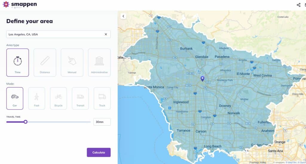
Creating a travel time map with Smappen can provide valuable insights for location-based decision-making. Below is a step-by-step tutorial on how to create a travel time map for free using Smappen:
- Go to smappen.com/app/
- Open the area creation panel on the top left
- Write your starting address
- Select the time
- Choose the means of transport
- Click on “Compute” button
Your first travel time area is created! For more detailed instructions, you can follow our tutorials .
Interpreting travel time maps
Understanding how to read and interpret a travel time map is vital in unlocking the wealth of information it offers to individuals, businesses, and decision-makers alike. These maps are designed to provide valuable insights into travel time, allowing for informed choices. Here, we’ll delve into the key aspects of interpreting travel time maps while incorporating relevant SEO keywords.
Color-Coding and Legends: A fundamental element of any travel time map is the color-coding scheme, where different areas are shaded in various colors to represent varying travel times. The intuitive use of colors serves as a visual guide, with darker hues typically signifying longer travel times and lighter shades indicating shorter journeys. Understanding these color patterns is crucial for quick and accurate interpretation of the map, especially when time is of the essence. Additionally, legends are often provided to clarify the specific time intervals associated with different colors, making it easier to gauge travel durations.
Real-World Examples and Decision-Making: The true power of travel time maps becomes evident when we witness them in action in real-world scenarios. These maps are not just abstract data representations; they play a practical role in guiding decisions. For instance, consider a business owner looking to determine the ideal location for a new store. By consulting a travel time map, they can pinpoint areas with shorter travel times to their target demographic, leading to better strategic choices. Similarly, urban planners utilize travel time maps to identify areas with limited transportation accessibility, paving the way for more efficient infrastructure development. These practical examples showcase the indispensable role travel time maps play in enhancing decision-making processes.
User-Friendly Digital Platforms: In the digital age, travel time maps have become more accessible and user-friendly than ever. Many platforms, such as Smappen, offer intuitive interfaces that make map interpretation a breeze. These digital tools allow users to zoom in, pan, and interact with the map, exploring different regions effortlessly. Whether you’re planning your daily commute or seeking the ideal location for a business expansion, the user-friendly nature of digital travel time maps streamlines the process. With a few clicks, you can gain valuable insights into travel times, empowering you to make more informed decisions in an ever-changing world.
By grasping the principles of color-coding, legends, and practical applications, you’ll be well-prepared to harness the potential of travel time maps in your daily life or business endeavors. Understanding how to interpret these maps effectively opens the door to better planning, improved decision-making, and optimized efficiency.
Applications and importance
Broad Applications Across Sectors: Travel time maps find relevance in a plethora of sectors, serving as a fundamental resource for informed decision-making. In the realm of transportation, they aid in optimizing routes and schedules for public transit systems, reducing commuter travel time and enhancing the overall transit experience. In healthcare, travel time maps guide medical facilities in identifying areas with limited accessibility, ensuring that critical services are within reach for all members of the community. Furthermore, urban planners employ travel time maps to develop efficient infrastructure and to design cities that are more accessible to all. These maps, enriched with data, play a pivotal role in enhancing the quality of life for residents and commuters alike.
Leveraging Travel Time Maps for Decision-Making: Businesses and individuals stand to gain significant advantages by leveraging travel time maps in their decision-making processes. For businesses, the strategic location of a store, warehouse, or distribution center can be a game-changer in terms of customer reach and operational efficiency. Travel time maps provide valuable insights into the ideal location for maximum accessibility. Individual commuters and travelers, too, can benefit from these maps by planning their daily journeys more efficiently, avoiding congestion, and optimizing their schedules.
Optimizing Efficiency and Accessibility: The value of travel time maps lies in their ability to optimize efficiency and accessibility in everyday life. For businesses, this means maximizing the reach of their services while minimizing operational costs. For individuals, it translates to reduced stress, more time for leisure and productivity, and a higher quality of life. With these maps in hand, individuals can make choices that take into account the time it takes to reach their destinations, ultimately improving the balance between their personal and professional lives.
Optimizing travel time with maps
Efficiently managing your travel time is not just about reaching your destination; it’s about transforming your daily journeys into smoother and more productive experiences. In this section, we will share practical strategies and tips for using travel time maps to your advantage, all while incorporating relevant SEO keywords for enhanced visibility.
Practical Strategies for Efficiency:
Plan Ahead: The cornerstone of optimizing your travel time begins with planning. Use travel time maps to foresee potential bottlenecks, traffic congestion, or delays in your route. By being proactive and considering these factors, you can plan your trips at times that minimize disruptions.
Combine Trips: If you have multiple errands or destinations, strategically combine them to minimize travel time. Travel time maps can help you identify areas where you can complete multiple tasks within a single journey, optimizing your schedule and reducing the overall time spent traveling.
Use a map radius tool to find new destinations

Remember the old song "500 Miles Away From Home"? Think of it as a challenge instead of a lament and you could come up with some good ideas for a road trip.
You can do it the old-fashioned way, calculating distances on a paper map using scale of miles and a ruler. But now there are free online map radius tools that show you at a glance which destinations are within a given distance.
One that's relatively simple to use is at freemaptools.com/radius-around-point.htm .
Go to the Web site and scroll down to the "Options" form. Type in the city you're starting from in "Place radius by location name."
Skip latitude and longitude and go to the "Radius Distance" section. Here the form automatically sets the radius distance to 1,000 kilometers, but you can reset by typing in the number of miles you're willing to drive in the "miles" box right next to the kilometer box.
Now go back up to the location name and click on "Draw Radius."
Scroll up to see the green circle on the map. Zoom in by grabbing the minus sign on the left and moving it up a couple of notches for a more detailed look at cities within your drive-to zone.
Depending on traffic and highway speed, most people can easily cover 500 miles in a day's drive, so starting with that distance could inspire some interesting choices. If you're taking a week's vacation, driving the first and last days to and from your destination is often an acceptable tradeoff to save on plane fare.
Starting with New York as a radius point on the FreeMapTools.com Web site, you quickly see that trips to Montreal, Toronto, Cleveland and Virginia Beach, Va., are well within the 500-mile radius.
Destinations at the very edge of the circle may be farther than your maximum distance once you calculate actual driving routes. The radius tool measures distance as the crow flies without considering highways or terrain, so it's good to check distances against a mileage calculator on MapQuest or GoogleMaps.
Safely inside the 500-mile circle around New York, the actual distance to Toronto is 475 miles; to Cleveland, 463 miles; to Montreal, 376 miles; and to Virginia Beach, Va., 362 miles. Greenville, N.C., appears near the edge of the 500-mile circle, and GoogleMaps' mileage calculator says the driving distance is just beyond 500 miles, at 522.
Checking out a few other starting points yields some great vacation ideas within a 500-mile circle: Baltimore to Myrtle Beach, S.C.; Denver to Mount Rushmore; Cleveland to Mammoth Cave in Kentucky; Minneapolis to Kansas City; Tucson to Los Angeles; Atlanta to Orlando; Boise, Idaho, to Portland, Ore.; Helena, Mont., to Salt Lake City.
If you're willing to make the seven-to-10 hour drive, the cost savings of a 500-mile road trip versus flying is considerable. For one person, it's not that much, but a family of four is likely to spend over $1,000 flying anywhere round-trip. Air travel also involves more than the cost of plane tickets; there's transportation to and from the airport, food and other incidentals, and car rental when you land.
In contrast, with gas around $2 a gallon, driving 1,000 miles in a car that gets 25 mpg will cost you well under $100. Even counting tolls, food and a night in a motel en route if you can't make the trip in a day, it's bound to run less than plane tickets. If you're feeling ambitious, leave before dawn and you can easily get to a destination 400 miles away by lunchtime.
Or if you're willing to leave at dawn and arrive by dinner, expand your radius to 800 miles and you greatly expand your vacation options. My husband and I managed to drive the 840-mile trip from New York to Mammoth Cave in one day with two kids (and no electronic devices to entertain them), and had a cheap and unforgettable vacation visiting the national park and nearby attractions.
While using a map radius can expand your list of potential vacation spots, the appeal is partly psychological. Many people are not good at estimating distances, and knowing exactly how far away something is can make it seem more attainable.
Besides, quantifying distances is something of a national pastime. Of course there are thousands of highway mileage signs that list distances to other cities, but there are also numerous examples of whimsical or wistful mileage signs.
U.S. soldiers on bases overseas sometimes erect handmade signposts listing the mileage to their favorite places and hometowns thousands of miles away. A sign in downtown Anchorage notes the distance to Tokyo and Paris. Many small towns in Maine are named for big cities around the world, so there are famous signposts at local crossroads showing place names like China, Norway, Mexico and Paris just a few miles down the road.
And when you get to the top of Mount Katahdin in Maine at the northern terminus of the Appalachian Trail, you're confronted with a sign that tells you Springer Mountain, Ga., at the southern end of the trail, is a mere 2,000 miles away.
Cities 3 hours from me
Tap the compass below to get your current location and map places 3 hours from where you are now. It may take a few seconds to get the GPS coordinates, so if you're in a hurry, you can enter your local city in the form instead.
Cities at a radius of
COMMENTS
Note: With this tool, you can know the radius of a circle anywhere on Google Maps by simply clicking on a single point and extending or moving the circle to change the radius on the Map. Click in the Button Draw a Circle, then Click on map to place the center of the circle and drag at same time to start creating the circle.
Explore a radius of 1 hour from Nashville TN, 100 miles of Boydton VA, or 1 hour from Boydton VA. Check out the latest coverage in the Los Angeles Times: If you're planning a road trip this summer, take Within Hours for a spin. The simple website allows you to plug in a destination and learn about nearby attractions. Or from Clark.com:
Create a drive time radius map: explore how far you can travel on a road trip. Use cases for businesses. Travel time mapping up to 4 hours & cross reference other data sets in GIS such as population data ; Site selection analysis: analyse the best location to locate a business by adding thousands of analysis points;
Plot a map showing where you can reach in a given time or distance from home or another point of origin, using plotaroute.com - a free online route planner for plotting and sharing your routes. The 'Plot a Radius Map' tool calculates how far you can go either as the crow-flies (a circle around the point of origin) or by following roads and paths (an isochrone).
A Driving Radius Map from OALLEY, showing travel 1.5 hours from New London, CT. How to Use OALLEY Map Radius Tool: Enter an address. Enter a distance or travel time. Hit "Compute". If you explore the app documentation, you'll find reference to two terms used in geography and urban planning.
Step 1. Become a Maptive user for FREE. Step 2. Upload your location data from Excel spreadsheets, Google Sheets, your own CRM, or copy-paste your data directly into Maptive. Step 3. Create your map and open the Radius and Proximity Tool-here, you can choose your location and customize your radius by distance or driving time. Step 4.
Did you know: If you use the Roadtrippers mobile app, your trips will instantly auto-sync over... Ready for navigation and good times! Search. The ultimate road trip planner to help you discover extraordinary places, book hotels, and share itineraries all from the map.
Click "Create Map" to instantly plot your data on an interactive map. Click the Tools icon in the top right corner of your screen. To find the distance between two locations, select the "Routing / Directions" tool. Enter your starting location and your destination to see the travel time. You can also add additional stops and determine ...
Click on "Add an area". Define your starting point address. Select the "travel-distance" mode. Then, click on "as-the-crow-flies" mode. And select the distance you need (in miles or kilometers) Click on Calculate. And there you go! You have your radius on a map, in less than 1 minute 🙂. With Smappen, you have a bunch of choice to ...
See how far you can travel in a time limit by car, public transport, walking & more. Search by Time. Create a 'X' minute radius map in seconds with this quick tool that draws circles around a point. Compare miles radius & kms radius to drive time areas & more.
A driving radius map is a powerful tool for businesses and individuals alike. It provides a visual representation of how far you can travel within a certain time frame or distance from a specific location. ... Explore the world with confidence and enjoy your road trips to the fullest with the help of a driving radius map. Navigating Real Estate ...
Provide up to 26 locations and Route Planner will optimize, based on your preferences, to save you time and gas money. Find the shortest routes between multiple stops and get times and distances for your work or a road trip. Easily enter stops on a map or by uploading a file. Save gas and time on your next trip.
The Trippy road trip planner automatically calculates the optimal itinerary including stops recommended by Trippy members, favorite restaurants and hotels, local attractions and things to do based on what people who live in the area have suggested, and more. Once you have a quick trip planned, you can customize every detail, adding or removing ...
Add your travel destinations on a map, select your transport modes, visualize and share your itinerary for free. My itinerary This is a free demo version of our mapping software. Create an account to save your current itinerary and get access to all our features. ...
Keep exploring with the Roadtrippers mobile apps. Anything you plan or save automagically syncs with the apps, ready for you when you hit the road! Download from Apple App Store Download from Google Play Store. Connect with us and hit up #roadtrippers. Plan your next trip, find amazing places, and take fascinating detours with the #1 trip planner.
It has become a go-to app for planning a road trip or delivering products and services to your customers. There are several features to utilize on Google Maps, making it a reliable and efficient map. One unique feature includes knowing how to draw a radius on Google Maps. Is this possible? Yes, it is! The ability to do so serves various purposes.
Find local businesses, view maps and get driving directions in Google Maps.
Smappen, as an innovative geomarketing solution, plays a significant role in creating travel time maps. It leverages GIS technology to process vast datasets and produce visually intuitive maps that help individuals and businesses make informed decisions. Creating a travel time map with Smappen can provide valuable insights for location-based ...
Hello! I'm trying to plan a family road trip from Florida. Unfortunately, it feels like everything is so far away geographically. I feel like I saw a tool linked her a couple years ago, I'm looking for some sort of tool, that I can put in a given location and a given amount of time, and get a sort of blob-like overlay on a map of where you could reach on X hours.
Starting with New York as a radius point on the FreeMapTools.com Web site, you quickly see that trips to Montreal, Toronto, Cleveland and Virginia Beach, Va., are well within the 500-mile radius.
Find cities within a 3 hours radius of me and look for places to visit within a 3 hours drive. ... Tap the compass below to get your current location and map places 3 hours from where you are now. It may take a few seconds to get the GPS coordinates, so if you're in a hurry, you can enter your local city in the form instead. Cities at a radius of
Whether you need to plan a road trip, a commute, or a walk, MapQuest Directions can help you find the best route. You can customize your journey with multiple stops, avoid tolls and highways, and get live traffic and road conditions. You can also discover nearby attractions, restaurants and hotels with MapQuest Directions.
Do you want to know how far you are going to travel and how much gas you will need? Use MapQuest's mileage calculator to estimate the distance, time and fuel cost of your trip. You can also get directions for driving or walking, and see live traffic and road conditions along the way.