- MOUNTAIN HUTS
- VIEWING PLATFORMS
- ALPINE TRAILS AND RINGS
- Open Dolomites
- High Quality
- Dolomites throughout the world

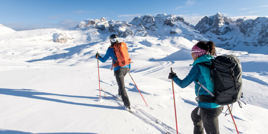
Dolomiti di Brenta Trek ALPINE TRAILS AND RINGS
Two tours for the price of one for trekking enthusiasts! This new hiking itinerary is a circular route that runs around the Brenta mountain in the western part of the UNESCO Dolomites. It lies in the heart of one of the wildest natural parks in Italy, the Adamello Brenta Natural Park.
The Dolomiti di Brenta Trek caters for two different kinds of walkers. The expert trail is designed for experienced, well-trained hikers who want a total mountain experience and the thrill of staying in high altitude mountain huts. The country trek is for those looking for a “tamer” experience who love walking surrounded by nature and culture but also want the commodity of resting in comfortable hotels after a day out walking.
For more information, visit www.dolomitibrentatrek.it

ALTE VIE ED ANELLI
Alta Via delle Dolomiti n. 1 Alta Via delle Dolomiti n. 2 Alta Via delle Dolomiti n. 3 Alta Via delle Dolomiti n. 4 Alta Via delle Dolomiti n. 5 Dolomiti Palaronda Trek Dolomiti Brenta Trek Via Transalpina Anello delle Dolomiti Friulane Anello del Lagazuoi Anello del Pelmo Anello del Vallòn Popèra Anello del Vescovà Anello del Civetta Anello Busa delle Vette Sentiero del Partigiano
A tailored experience.
This website uses technical cookies and, subject to prior consent, first- and third-party analytical and profiling cookies. If you close the banner, the settings remain in place and you continue browsing in the absence of cookies other than technical ones. Your consent to the use of cookies other than technical ones is optional and can be withdrawn at any time by setting your cookie preferences . For more information on each type of cookie we use, you can read our Cookie Policy .
Cookies used
Necessary technical cookies.
Always active
The necessary technical cookies cannot be deactivated, as the website would not be able to function properly without them. The Site uses first-party, session and persistent cookies to provide you with our services. These help enable basic functionality such as page navigation, language preference and access to secure areas of the site.
First Party 4
Cm_cookie_visit-dolomites.
Checks cookie acceptance.
Lifetime 6 months
Domain www.visitdolomites.com
slimstat_tracking_code
Provides anonymous information on how the visitors navigate the site.
Lifetime 30 minutes
Contains information on viewport and screen resolution.
Lifetime Session
wp-wpml_current_language
Makes it possible to save language settings.
Lifetime 1 days
Mappa Prenota
Mappa Meteo
- Il mio viaggio
- Richiesta info
- Dolomiti Brenta Trek Expert
- Download PDF
- Download GPX
- Descrizione
- Direzioni da seguire
- Attrezzatura
Dati percorso
Consiglio dell'autore.
Bibliografia: Per i GRANDI SENTIERI DELLE DOLOMITI: il BRENTA di Alessandro Cristofoletti, contributi scientifici a cura di Efrem Ferrari
Cartografia: CARTOGRAFIA 4LAND, CS-139, GRUPPO DI BRENTA . Edizioni 4Land, Formato: 100x132 cm, Formato chiuso 11x20 cm
Indicazioni sulla sicurezza
Come immaginerai, la percorribilità degli itinerari in un ambiente montano è strettamente legata alle condizioni contingenti e dipende quindi da fenomeni naturali, cambiamenti ambientali e condizioni meteo. Per questo motivo, le informazioni contenute in questa scheda potrebbero aver subito variazioni. Prima di partire, informati sullo stato del percorso contattando il gestore dei rifugi sul tuo percorso, le guide alpine, i centri visitatori dei parchi naturali e gli uffici turistici.
Indicazioni
TAPPA 1. LAGO DEL DURIGAT - BIVACCO COSTANZI
Distanza: 8,5 km
Dislivello in salita: 695 m
Tempo di percorrenza: 4,30 ore
Dal Lago del Durigat (m. 1869) si prosegue lungo la strada forestale segnalata SAT 313 e in 10 minuti si raggiunge un bivio: da qui salendo il Rifugio Peller (m. 1990) è raggiungibile in 5 minuti.
Il DBT Expert procede diritto lungo la strada forestale pianeggiante e raggiunge la malga Clesera (m. 1889) in 45 minuti.
Dalla Malga Clesera di imbocca il sentiero SAT 308 (E) che conduce con una piccola salita al Lago delle Salare (m. 2004). Qui si abbandona il segnavia SAT 308 (E) per raggiungere il Passo della Forcola (m. 2105) poco più in alto sulla sinistra. Bello il panorama sul Monte Peller lasciatosi alle spalle. Tempo di percorrenza Malga Clesera – Passo della Forcola 45 minuti.
Dal Passo della Forcola si scende al verdissimo Pian della Nana, una zona dove spesso si avvistano marmotte, per ricongiungersi al Sentiero Alpinistico Attrezzato “Claudio Costanzi” SAT 336 (EEA – D) che attraversa tutto il Piano passando per il Passo della Nana (m. 2195) fino al versante Est della Cima Nana in ore 2. Qui si abbandona il sentiero Costanzi per raggiungere la Selletta della Nana (m. 2530) e prendere il Sentiero G. Albasini che scende al Bivacco A. Costanzi (m. 2365) in 30 minuti dove si trova anche una sorgente.
Dotazioni bivacco: materassi, coperte, cuscini tavola, panche, taniche per acqua
TAPPA 2. BIVACCO COSTANZI - RIFUGIO GRAFFER
Distanza: 14,4 km
Dislivello in salita: 1272 m
Tempo di percorrenza: 5.45 ore
Dal Bivacco si risale in 30 minuti lungo il segnavia SAT 365 (EE) fino a ricongiungersi con il sentiero SAT 329 (EE) che scende verso la selvaggia Val del Vento fin ai ruderi di Malga Scale (m. 1590) in ore 1,30.
Dal prato della Malga Scale si procede in saliscendi lungo il sentiero SAT 355 (T) che attraversa la Val Centonia e porta al bivio (m. 1505) con la strada forestale che in salita raggiunge Malga Mondifrà (m. 1632). Tempo di percorrenza Malga Scale – Malga Mondifrà ore 2.
L’ultimo tratto del percorso Expert da Malga Mondifrà al Passo del Grostè segue sentieri non numerati dalla SAT ma comunque dotati di segnaletica.
Da Malga Mondifrà si segue l’indicazione per Malga Vaglianella (m. 1826) che si raggiunge in 30 minuti percorrendo in parte sentiero e in parte strada forestale. Dalla Malga Vaglianella si prosegue sulla strada forestale che in altri 30 minuti conduce a Malga Vagliana (m. 1974) e da qui si prosegue diritti sul sentiero che sale abbastanza ripido fino a quota 2180 m. Qui il panorama cambia radicalmente: alle spalle il verde delle malghe e dei pascoli della Val di Sole e di fronte a se le cime frastagliate e i ghiaioni delle cime Pietra Grande e Grostè. In ore 1,15 il sentiero procede pianeggiante fino al Rifugio Graffer (m. 2263). Tempo di percorrenza Molga Mondifrà – Passo del Grostè ore 2.15.
TAPPA 3. RIFUGIO GRAFFER - RIFUGIO BRENTEI
Dislivello in salita: 415 m
Tempo di percorrenza: 3,00 ore
Dal Rifugio Graffer (m. 2263) si sale lungo il sentiero SAT 331 (E) fino a incrociare in ore 0.30 il sentiero SAT 316 (E) che proviene dal Passo Grostè e che con un semplice saliscendi porta al Rifugio Tuckett (m. 2271) in ore 1.00.
Si prosegue in discesa lungo il dolce e panoramico sentiero SAT 328 (E) verso la Sella del Fridolin (m. 2143) attraversando prima ghiaioni e poi una mugheta. Poco sotto l’erbosa Sella del Fridolin si incontra il bivio con il Sentiero Bogani SAT 318 (E) che sale dal Rifugio Casinei. Seguendo questo segnavia 318 ci si alza costeggiando la scoscesa destra orografica della Val Brenta e si percorre la Galleria Bogani che permette di evitare un tratto molto esposto fino raggiungere il rifugio Maria e Alberto ai Brentei (m. 2182). L’ itinerario che congiunge i due rifugi è un percorso classico che non presenta difficoltà particolari ad eccezione di un tratto leggermente esposto nei pressi della Galleria Bogani. Tempo di percorrenza Rifugio Tuckett – Rifugio Brentei ore 1.
D’ora in poi e fino alla Malga Spora il percorso DBT Expert è considerato per escursionisti esperti con attrezzatura e presenta molte difficoltà. E’ necessario l’uso di imbraco, kit da ferrata, casco e ramponi.
TAPPA 4. RIFUGIO BRENTEI - RIFUGIO XII APOSTOLI
Distanza: 5 km
Dislivello in salita: 923 m
Tempo di percorrenza: 3,30 ore
Dal Rifugio Brentei si prosegue sul Sentiero Alpinistico “Daniele Martinazzi” SAT 327 (EEA – MD) che attraversa il fondo della Val Brenta passando ai piedi della parete ghiacciata del Canalone Neri che salda assieme la Cima Tosa al Crozzon di Brenta e risale sul versante opposto fino a portarsi proprio sotto lo spigolo Nord del Crozzon di Brenta. Da qui si avanza costeggiando la parete Ovest del Crozzon e si raggiunge su rocce attrezzate e neve la Bocca dei Camosci (m. 2784) attraversando la Vedretta omonima. Tempo di Percorrenza Rifugio Brentei – Bocca dei Camosci ore 2.45.
Dalla Bocca dei Camosci si scende al Rifugio XII Apostoli (m. 2487) in circa 45 minuti percorrendo su ghiaioni il Sentiero Alpinistico Attrezzato dell’Ideale SAT 304 (EEA – MD).
TAPPA 5. RIFUGIO XII APOSTOLI - RIFUGIO AGOSTINI
Distanza: 2,5 km
Dislivello in salita: 364 m
Tempo di percorrenza: 2,30 ore
Dal Rifugio XII Apostoli si risale lungo la Via Ferrata “Ettore Castiglioni” SAT 321 (EEA – MD) fino alla Bocchetta dei Due Denti (m. 2859) in ore 1.10. Questo tratto iniziale del sentiero non è attrezzato, gli infissi si trovano dalla Bocchetta in poi. Dalla Bocchetta dei Due Denti la via scende attrezzata con scale in ferro che necessitano la dotazione di imbraco e casco. Questo tratto molto panoramico e decisamente esposto con strapiombi verticali sulla Conca della Val d’Ambiez si sposta poi su ghiaioni che raggiungono il Rifugio S. Agostini (m. 2405) posto proprio ai piedi della Cima d’Ambiez (m. 3103) famosa per le sue vie. Tempo di percorrenza Rifugio XII Apostoli – Rifugio S. Agostini ore 2.30.
TAPPA 6. RIFUGIO AGOSTINI - RIFUGIO PEDROTTI
Distanza: 6 km
Dislivello in salita: 478 m
Sotto il Rifugio S. Agostini si stacca il Sentiero Basso “Elio Palmieri” SAT 320 (E) poco faticoso e di interesse panoramico che attraversa l’anfiteatro dell’Alta Val d’Ambiez e sale alla Forcolotta di Noghera (m. 2423) in ore 1 su un facile sentiero in saliscendi. Si prosegue sempre per il segnavia SAT 320 che dalla Forcolotta entra nell’Alta Val di Ceda, scende leggermente e costeggia la profonda depressione carsica della Pozza Tramontana. Il sentiero aggira l’enorme Pozza Tramontana senza toccarne il fondo e risale al piede della parete S della Cima Brenta Bassa dove incontra il bivio con il sentiero SAT 358 (EEA – D). Tempo di percorrenza Forcolotta di Noghera – Bivio SAT 358 ore 1. Al bivio si prosegue sul sentiero SAT 358 (EEA – D) che in 30 minuti porta al Rifugio Pedrotti e Tosa (m. 2491). Tempo di percorrenza totale Rifugio S. Agostini – Rifugio Pedrotti Tosa ore 2.30.
TAPPA 7. RIFUGIO PEDROTTI - MALGA SPORA
Distanza: 9,5 km
Dislivello in salita: 1007 m
Tempo di percorrenza: 6,00 ore
Dal Rifugio Pedrotti si scende per qualche minuto fino a un ripiano subito sotto il Rifugio Tosa (m. 2439) e si imbocca il segnavia SAT 303 (EEA – D) Sentiero Attrezzato “Osvaldo Orsi” che aggira a saliscendi la base del grosso fianco roccioso della Cima Brenta Alta e dopo un breve tratto sbuca nella Busa degli Sfulmini e dei Massodi (m. 2380) coronata dalla stupenda muraglia della Cima Brenta Alta, il Campanil Basso e Alto e la Cima degli Sfulmini. Il sentiero percorre tutta la soglia della conca, prosegue piano nella Busa dei Armi (m. 2450) e sale poi brevemente al piede del Naso dei Massodi (m. 2510) da dove si affaccia sulla Val Perse. Da qui il sentiero percorre una comoda cengia attrezzata con coda metallica (la Sega Alta) incavata nella parete strapiombante e scende lungo un breve dirupo nella Val Perse. Restando in quota e attraversando ghiaie e nevai si aggira la base della parete E della Cima Brenta e si risale su ghiaie fino poco sotto la Bocca del Tuckett (m. 2540) dove è evidente il bivio con il sentiero SAT 322 (EE). Tempo di percorrenza Rifugio Pedrotti Tosa – bivio SAT 322 ore 2,30). Questa zona selvaggia e ghiaiosa offre una continua varietà di scenari e regala panorami suggestivi sulle guglie frastagliate tipiche del Brenta. E’ necessario l’utilizzo di casco e ramponi e in alcuni punti il sentiero è attrezzato con cordini.
Da sotto la Bocca del Tuckett si scende di molto lungo il Sentiero delle Val Perse SAT 322 (EE) attraversando la Busa dell’Acqua (m. 1955) e si raggiunge in circa ore 1.30 il bivio (m. 1600) con il sentiero SAT 344 (E) sul fondovalle della Vallazza. Seguendo il segnavia SAT 344 (E) si risale l’altro versante lungo un sentiero molto ripido e impegnativo che raggiunge il Passo del Clamer (m. 2164) in ore 1.30.
Qui inizia la seconda parte del percorso che si sviluppa nella zona più selvaggia e sconosciuta del Gruppo. Dal Passo Clamer si ha un’ultima vista spettacolare sul massiccio roccioso del Brenta Centrale che si ha appena percorso attraversato da ampi ghiaioni, scavato da depressioni carsiche e costernato di vedrette e nevai. D’ora in poi l’itinerario sarà caratterizzato da verdi vallate ricche di flora, fauna, praterie e malghe. Lo stacco dal grigio delle rocce al verde habitat dell’orso è notevole.
Dal passo Clamer si prosegue in discesa lungo il semplice pendio erboso del sentiero SAT 344 (E) che in 30 minuti raggiunge la Malga Spora (m. 1855) (dotata di bivacco).
TAPPA 8. MALGA SPORA - MALGA FLAVONA
Distanza: 17,5 km
Dislivello in salita: 1200 m
Tempo di percorrenza: 5,45 ore
Dalla Malga Spora si prosegue lungo il segnavia SAT 301 (EE) che scende dal Rifugio Graffer e prosegue verso Andalo attraversando la zona dei larici monumentali. Si raggiunge in 30 minuti il prato della Malga Cavedago dove si prende il bivio (m. 1848) con il sentiero SAT 338 (E) che risale tutta la bellissima Val dei Cavai fino alla Sella del Montoz (m. 2327) in ore 1 con una salita non troppo faticosa. Dalla Sella si scende in ore 1 alla Malga Campa (m. 1975) (dotata di bivacco).
Dalla Malga Campa il sentiero SAT 370 (E) risale velocemente fino alla Bocchetta della Campa e poi scende per mugheti e lariceti fino alla Malga Loverdina (m. 1768). Tempo di percorrenza Malga Campa – Malga Loverdina ore 1.
Dalla Malga Loverdina si deve proseguire in direzione della Malga Termoncello (m. 1852) (dotata di piccolo bivacco) sul sentiero SAT 339 (E) fino a raggiungere il Passo Termoncello (m. 1856) in 30 minuti. Al Passo Termoncello si prende il sentiero SAT 330 (E) lungo ma pianeggiante che rimanendo in quota e alternando i ghiaioni della Val Strangola a mugheti offre meravigliosi panorami sul Lago di Tovel e raggiunge la Malga Flavona (m. 1858) in ore 1.45.
TAPPA 9. MALGA FLAVONA - MALGA TUENA
Distanza: 8 km
Dislivello in salita: 694 m
Tempo di percorrenza: 3 ore
Il percorso DBT Expert prosegue da Malga Flavona imboccando il sentiero SAT 371 (E) che scende in 30 minuti fino a Malga Pozzol (m. 1632) dotata di bivacco ed entra nella foresta di larice e abete rosso tipica della Val di Tovel. Dalla Malga Pozzol si segue il segnavia SAT 314 (E) su strada forestale che in 40 minuti porta all’incrocio con il Sentiero della Dena SAT 312 (E). Dopo 30 minuti di cammino in salita costante sul segnavia 312 si svolta a destra seguendo le indicazioni Dolomiti di Brenta Trek su un sentiero non SAT. Questo sentiero ricco di fauna selvaggio e suggestivo aggira il Dos De La Mandra e in 1,20 ore di saliscendi porta all’ Agritur Malga Tuena (m. 1740) che offre vitto e alloggio.
TAPPA 10. MALGA TUENA - LAGO DEL DURIGAT
Dislivello in salita: 682 m
Tempo di percorrenza: 3,10 ore
Dalla Malga Tuena si prende una forestale che scende verso il fondovalle. Dopo circa 10 minuti si dirama sulla sinistra il sentiero SAT 311 (E) indicato da una tabella di legno apposta su un albero che da come indicazione il Rifugio Peller. Questo conduce in ore 2,10 al Pian della Nana dove poco prima della Malga Tassulla (m. 2090) si immette sul segnavia SAT 336 (E) raggiungendola in 5 minuti.
Seguendo il segnavia SAT 336 (E) si prosegue dalla Malga Tassulla su strada forestale per 45 minuti fino al Lago del Durigat (m. 1869) aggirando il Monte Peller. Il Rifugio Peller dista solamente 15 minuti dal Lago del Durigat e si raggiunge proseguendo su strada forestale segnavia SAT 313.
VARIANTI AL DOLOMITI BRENTA TREK EXPERT
VARIANTE MALGA FLAVONA – PASSO GROSTE’
Chi fosse partito da Campo Carlo Magno ha la possibilità ora di accorciare il giro tagliando dal Passo Grostè e di ricongiungersi rapidamente in 3 ore di cammino al passo stesso tralasciando quindi tutto il settore di DBT che sovrasta il Lago di Tovel e percorre la zona del Monte Peller.
Distanza: 7,6 km
Dislivello in salita: 582 m
Tempo di percorrenza: 2,40 ore
Dalla Malga Flavona si risale l’altopiano pascolivo di Campo Flavona (m. 2198) lungo il sentiero SAT 371 (E) fino a ricongiungersi in ore 1.20 con il sentiero SAT 301 (E) che sale da Malga Spora. Si sale verso il Passo Grostè in ore 1.40 lungo il sentiero SAT 301 (E) con passaggi su roccette non impegnativi e passando la Sella del Turion (tra il Monte Turrion Alto e Basso). Questa è una zona interessante dal punto di vista geologico perché si tratta di un altipiano scavato da fenomeni carsici.
VARIANTE MALGA SPORA – PASSO GROSTE’
Chi fosse partito da Campo Carlo Magno ha la possibilità ora di accorciare il giro tagliando dal Passo Grostè e di ricongiungersi rapidamente in 3 ore di cammino al passo stesso tralasciando quindi tutto il settore più verde e selvaggio del DBT che sovrasta il Lago di Tovel e percorre la zona settentrionale del Monte Peller.
Distanza: 6,1 km
Dislivello in salita: 591 m
Dalla Malga Spora si sale passando il versante est del Crozzon della Spora lungo il sentiero SAT 301 (E) fino al Passo della Gaiarda (m. 2242) in ore 1,20. Da qui si scende leggermente e poi si risale verso il Passo Grostè in ore 1.40 con passaggi su roccette non impegnativi e passando la Sella del Turion (tra il Monte Turrion Alto e Basso). Questa è una zona interessante dal punto di vista geologico perché si tratta di un altipiano scavato da fenomeni carsici.
VARIANTE RIFUGIO BRENTEI – RIFUGIO PEDROTTI TOSA
Il tempo di percorrenza totale dal rifugio Brentei al Rifugio Pedrotti Tosa passando per il Rifugio XII Apostoli e il Rifugio Agostini è di ore 8.30 lungo sentieri classificati EEA-MD, cioè attrezzati con infissi e adatti ad escursionisti alpinisti esperti dotati di imbraco, casco e ramponi. La variante proposta di seguito permette di evitare i sentieri alpinistici e le vie ferrate descritte sopra e accorcia il tempo necessario per l’attraversata dal Rifugio Brentei al Rifugio Pedrotti Tosa.
Distanza: 3,1 km
Dislivello in salita: 400 m
Tempo di percorrenza: 1,10 ore
Dal Rifugio Brentei si sale lungo il segnavia SAT 318 (EE nel tratto Rifugio Brentei – Bocca di Brenta) chiamato anche sentiero dei Brentei. Si raggiunge la Bocca di Brenta (m. 2552) passando ai piedi del Campanil Basso e attraversando ampi ghiaioni. La Bocca di Brenta è una selletta rocciosa e detritica che mette in comunicazione la Val Brenta (Rifugio Brentei) con il Vallone dei Massodi (Rifugio Tosa). Costituisce il valico più importante e frequentato del Gruppo di Brenta e la sua traversata fu per la prima volta intrapresa nel lontano 1864 da J. Ball. Dalla Bocca di Brenta si scende fino a raggiungere in breve tempo il Rifugio Pedrotti (m. 2487). Tempo di percorrenza Rifugio Brentei – Rifugio Pedrotti ore 1.10.
- Kit da ferrata (caschetto, imbrago e set da ferrata) obbligatorio e si sceglie di percorrere la Ferrata Castiglioni. Il kit da ferrata non è necessario se si sceglie di evitare questo tratto tramite la Variante che dal Rifugio Brentei porta direttamente al Rifugio Tosa Pedrotti tramite la Bocca di Brenta.
- Ramponi : poco prima di partire chiedere ai rifugisti se sono necessari i ramponi 12 o 6 punte. Per il Sentiero Martinazzi (tra Rif. Brentei e Rif. XII Apostoli) e Bocca di Brenta (tra Rif. Brentei e Rif. Pedrotti) contattare il Rif. Brentei; per il Sentiero Osvaldo Orsi (tra Rif. Pedrotti e Malga Spora) contattare il Rif. Pedrotti. I ramponi sono particolarmente necessari indicativamente ad inizio e fine stagione estiva e per chi parte dal Rif. Brentei e dal Rif. XII Apostoli la mattina presto: in questi casi è probabile che le vedrette presso la Bocca dei Camosci e la Bocca dei Due Denti siano ghiacciate per il freddo della notte.
- Piccozza : talvolta necessaria ad inizio stagione in caso di inverni nevosi. Verificare presso i rifugi come indicato sopra per il caso dei ramponi.
- Scarponi e materiale classico da montagna per trekking di più giorni.
- Ricambi vestiti tecnici.
- Giacca a vento o abito impermeabile antipioggia.
- Bastoncini telescopici.
- Frontalino.
- Sacco lenzuolo (è obbligatorio il suo utilizzo nei rifugi, il sacco a pelo non serve): ogni rifugio bivacco è dotato di coperte (chiedere al gestore o pastore).
- Borraccia per l’acqua capiente.
- Cibo al sacco per i pernottamenti in bivacco (acquistabile anche nei rifugi o nelle malghe che producono formaggio).
- NON è necessario il fornello da campo.
- Campiglio Dolomiti di Brenta
- Pontedilegno-Tonale
- Uno Di Un Milione
- Parco Nazionale dello Stelvio
- Parco Naturale Adamello Brenta
- Parco Fluviale Alto Noce
- Wow Experience
- Sostenibilità
- Mobiltà sostenibile
- Pejo Plastic Free
- Val di Sole Ritorno al Futuro
- Rifugi sostenibili
- Sci & Snowboard
- Ciaspole e passeggiate
- Sci alpinismo
- Tra neve e ghiaccio
- Idee estate
- Idee inverno
- Benessere e Detox
- Passeggiate
- Luoghi slow
- Pista ciclabile
- Raccolta funghi
- Equitazione
- Mangiare e bere
- Prodotti tipici
- Musei e castelli
- Arte e artigianato
- Itinerari storico culturali
- Sulle tracce della Grande Guerra
- Dove dormire
- Pacchetti vacanza
- Il Bramito del Cervo
- Come arrivare
- Come muoversi
- Informazioni
- Uffici informazioni
- FAQ L'Orso in Trentino
- Appuntamenti
- Prenota la tua esperienza
- Prenota il tuo soggiorno
- Aggiungi al mio viaggio" data-watchlist-remove-content=" Elimina dal mio viaggio" data-container="body" data-trigger="hover" data-toggle="popover" data-placement="top" data-html="true" data-content="">

- Alle Touren
- Hüttentrekking
- Tourenempfehlungen
- Rother Alpenvereinsführer
- Tourenplaner
- Gemeinsame Touren
- Aktuelle Bedingungen
- Hinweise und Sperrungen
- Lawinenlage
- Mit Kindern auf Hütten
- Mit Öffis zum Berg
- Service für Mitglieder und Sektionen
- Das Abo-Modell auf alpenvereinaktiv.com
- Monats- und Jahresgutscheine
- Hilfe-Seite
- Video Tutorials
Dolomiti di Brenta Trek Expert Variante

Hallo zusammen, wir würden diese Tour gerne in 6 Tagen mit ...
Unterwegs auf einer sehr schönen Variante des Dolomiti di Brenta Trek Expert als 5-Tages-Rundtour mit langen Etappen und leichtem Gepäck.
Ausgangs- und Endpunkt in Folgarida. Von Rifugio Graffer bis Malga Flavona auf dem Original-Trek. Den südlichsten Teil mit Agritur Malga Tuena und Rifugio Peller habe ich nicht gemacht.
Ich bin Mitte Juni losgegangen, nach einem schneereichen Winter, in einer warmen Schönwetterphase. Der Schnee war oberflächlich aufgeweicht und nie richtig hart. Alle benötigten Steige waren trocken und schneefrei bzw. in leichtem Fels oder griffigem Schnee zu umgehen. Mit fortschreitendem Abschmelzen oder nach kalten Nächten kann sich dies jedoch schlagartig ändern! Achtung, es müssen steile Schneefelder gequert werden, eine sichere Technik ist Voraussetzung, es sind gute Schuhe und nach Verhältnissen auch Steigeisen/Pickel/Grödel erforderlich!
auf dem Weg von der Rifugio Maria e Alberto ai Brentei (2182 m) zur Bocca dei Camosci (2784 m) war der viele Schnee ein Vorteil: Ich konnte mitten auf dem Gletscher Vedretta dei Camosci gehen. Das Benutzen des Weges “Daniele Martinazzi” an der Westflanke des Crozzons wäre gefährlich bis unmöglich gewesen.
Die hohen Hütten hatten alle ein paar Tage zuvor geöffnet. Die Malgas im südlichen Teil sind (teilweise sehr schöne) Biwaks mit Selbstversorgung. Wasser, Holz, alte Matrazen, Holzherd, elektr. Licht vorhanden. Achtung: Feuerzeug nicht vergessen (musste meines wieder mitnehmen).
Tag 1 (17.6.2018)
Folgarida (1350 m) - Malga Scale (1590 m) - Malga Mondifrà (1632 m) - Malga Vagliana (1974 m) - Rifugio Graffer (2263 m) - Rifugio Tuckett (2271 m)
Tag 2 (18.6.2018)
Rifugio Tuckett (2271 m) - Rifugio Maria e Alberto ai Brentei (2182 m) - Bocca dei Camosci (2784 m) - Rifugio XII Apostoli (2489 m) - „Bocchetta dei Due Denti“ (2859 m) - Via „Ferrata Castiglioni“ - Rifugio XII Apostoli (2489 m) - Rifugio Pedrotti und Tosa (2491 m)
Tag 3 (19.6.2018)
Rifugio Pedrotti und Tosa (2491 m) - Klettersteig „Osvaldo Orsi” - „Passo del Clamer“ (2164 m) - Malga Spora (1855 m)
Tag 4 (20.6.2018)
Malga Spora (1855 m) - Malga Campa (1975 m) - Malga Flavona (1858 m) - Passo del Grostè (2442 m) - Rifugio Graffer (2263 m)
Tag 5 (21.6.2018)
Rifugio Graffer (2263 ) - Malga Vaglianelle (1840 m) - Campo Carla Magno (1620 m) - Malga di Vigo (1800 m) - Malga Folgàrida Dimaro (1660 m) - Folgarida (1350 m)
Wegbeschreibung
Sehr detaillierte Beschreibungen der einzelnen Etappen einschließlich meiner Variante "Malga Flavona" - "Rifugio Graffer" sind auf der offiziellen Webseite zu finden:
http://www.dolomitibrentatrek.it/lang/DE/pagine/dettaglio/dbt_expert_tour,54/scopri_il_dbt_expert_tour,342.html
Koordinaten
Buchtipps für die region, kartentipps für die region, ähnliche touren in der umgebung.
- Cima Sasso Rosso
- Dalle Glare al Lago di Tovel
- Da rifugio Nambino a Lago Nero
- Cammino di San Vili - Hohe Route
- Cammino San Vili - Niedrige Route
Fragen & Antworten

Bewertungen
Gib die erste Bewertung ab und hilf damit anderen.
Fotos von anderen
Wetter am startpunkt der tour.
- Bilder einblenden Bilder ausblenden
- Route planner
Lakes, pastures and mountains – Dolomiti di Brenta Bike Expert
West of the Adige River lies a true paradise for hikers and mountaineers, which in winter turns into one of the most popular ski areas in Italy: the Brenta Dolomites. This striking Dolomite group is part of the Adamello-Brenta Natural Park and has been recognised for the uniqueness and beauty of its landscape, as well as for its geological importance, as a UNESCO World Heritage Site. The rock formations that characterise it, the valleys and villages that surround it, and a landscape made up of enchanting alpine lakes, powerful waterfalls, ancient glaciers and centuries-old forests, make it one of the most evocative corners not only of the Rhaetian Alps but probably of the entire Trentino region. The itinerary I propose to you is the Dolomiti di Brenta Expert, a ring of about 170 kilometres (106 mi) that develops around this Dolomite group. Starting from some of the most iconic valleys in Trentino – such as Val di Sole and Val di Non – the route takes you almost to the summit of Monte Peller and Cima Brenta. This is the link to the official website of the itinerary: dolomitibrentabike.it/en/mountain-bike-tours/dolomiti-di-brenta-bike-expert For this Collection, I have chosen the village of Stenico as the starting point and divided the itinerary into four stages of between 40 and 50 kilometres (25 - 31 mi) each. Along the route, you pass through numerous villages ready to welcome you with a hot meal and a comfortable room to spend the night. However, on a couple of occasions, you will cycle several kilometres away from villages and into remote natural landscapes. I, therefore, advise you to study the route carefully before setting off if you choose to plan differently to this Collection. Some sections of the route are on high mountain trails and demand good technical ability. In addition, it’s useful to have some familiarity with basic repairs: knowing how to repair or replace an inner tube, for example, will get you out of trouble in the event of a puncture far from town. As for the choice of bicycle, I recommend you opt for a mountain bike with a fork with at least 100 millimetres of travel. A higher excursion or the choice of a full-suspension mountain bike will only increase safety and riding pleasure. The best time to embark on this adventure is from June to September, as during the other months it may be uncomfortable to ride in the cold and snow. Moreover, the Peller Refuge, where the second stage ends, is usually open from mid-June to mid-September. It’s always a good idea to ascertain in advance when accommodation is open. To reach Stenico, you can use a car or public transport. The car is undoubtedly the most comfortable and fastest means of transport. If you prefer to travel by public transport, you can reach Trento by train and here take bus B201 to Ponte Arche. Here you can take bus B208 or cycle to Stenico, which is about 3.5 kilometres (2 mi) away. You can find information on public transport in Trentino here: trentinotrasporti.it/en .
Do it yourself
Ready to get going? Create and customize your own version of this adventure using the full Tour below as a template.
Dolomiti di Brenta Bike Expert
Last updated: April 18, 2024
Stage 1: Stenico to Sporminore – Dolomiti di Brenta Bike Expert
Stage 2: sporminore to rifugio peller – dolomiti di brenta bike expert.
The second stage of the Brenta Dolomites Bike Expert will let you discover the Val di Non and will take you from Sporminore to the 2,022 meters above sea level of the Peller refuge, almost at the top of the homonymous mountain. Outside the refuge, the view is magnificent and there are a couple of benches … read more
by Emiliano Manzan
Sign Up To Discover Places Like This
Get recommendations on the best single tracks, peaks, & plenty of other exciting outdoor places.
Stage 3: Rifugio Peller to Madonna di Campiglio – Dolomiti di Brenta Bike Expert
As you prepare for another day in the saddle, outside the Peller Refuge you can breathe in the fresh, pungent air and watch the sun show as it creates evocative plays of light on the rock walls of the surrounding mountains. Today's stage is the hardest of all, although the long and fun initial descent … read more
Stage 4: Madonna di Campiglio to Stenico – Dolomiti di Brenta Bike Expert
The fourth and final stage of the Dolomiti di Brenta Bike Expert begins in Madonna di Campiglio and ends in Stenico, after about 40 kilometers and 1,200 meters of positive difference in altitude. In the first part of the stage you will cross the beautiful and little known Val d'Agola. In the second part … read more
Like this Collection?
Collection stats.
- Distance 107 mi
- Duration 18:28 h
- Elevation 19,575 ft
You Might Also Like
- Trip Finder
- View Catalog
- Subscribe to Newsletter
- Contact/Request Info
- Client Portal
- SUBSCRIBE TO NEWSLETTER
- About Ryder Walker
- About Our Inns
- Meet Our Team
- Guest Reviews
- Special Offers
- Awards & Stories
- Conditions & Policies
- Guided Hiking Tour Schedule
- Easy Going-Moderate Treks
- Moderate-Challenging Treks
- Challenging Treks
- The Dolomites
- Swiss Engadine
- Berner Oberland
- Tour du Mont Blanc
- Switzerland
- Private Hikes
- Self-Guided Tour Schedule
- Easy Going Treks
- Liechtenstein
- Berner Oberland Mini Trek
- Chamonix To Champex Mini Trek
- The Heart of Austria Mini Trek
- Italian Dolomites Mini Trek
- Swiss Engadine Mini Trek
- Telluride Mini Trek
Self-Guided Hiking Tours
Italy | dolomiti di brenta, hike the rugged side of the dolomites..

- "We are back from our adventure in the Brenta Dolomites and wanted to let you know that we had a wonderful time - it was a classy and adventurous trip. The trip turned out to be everything I had hoped it would be, and the whole family agrees with that assessment. My children and their spouses are very athletic and this trip challenged all of them. We spent our evenings and mornings together and then my husband and I left for the hike a few hours before the kids. They would eventually catch up with us and pass us. We had lots of time together, but also plenty of time apart. It was the perfect combination." - Alice Samuelson
REQUEST MORE INFO | TRIP ITINERARY & MAP | FAQs
Trip Highlights :
Hike along the brenta trek expert , a famous long distance, trans-brenta footpath., rub elbows with local alpinists at the rifugio brentei, an italian mountaineers' hut., sip cappupuccino along the shores of lago di molveno , one of italy's best-kept-secret lakes..
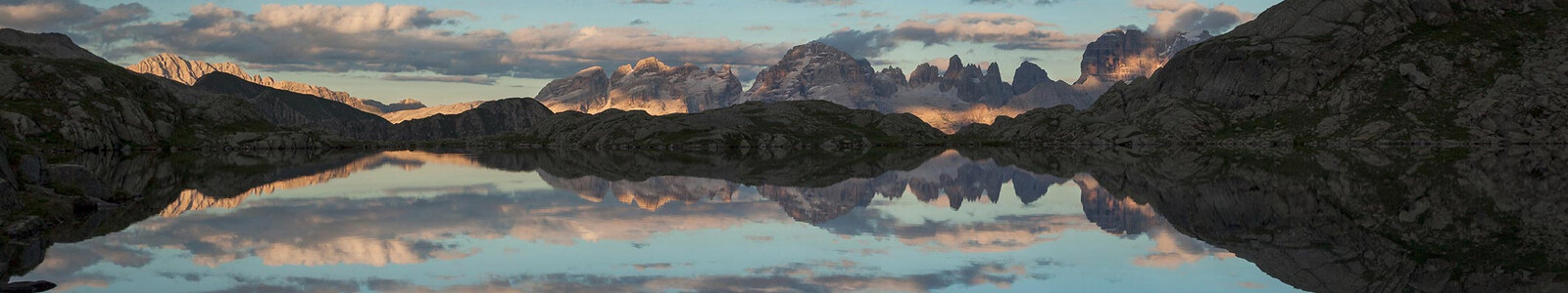
Unlock the mysteries of the Brenta Dolomites, Italy’s westernmost extremity of rugged limestone peaks. Bordered by the Swiss Alps to the west and the Austrian Alps to the north, the Brenta mountains tower above celebrity-studded Lake Garda and its lesser known, but equally spectacular, Lago di Molveno . Similar to the rest of the Dolomites range that stretches across northeastern Italy, the Brenta mountains are renowned for the spectacular colors they reflect during sunsrise and sunset. Unlike the bulk of the Dolomites, however, where Austro-Hungarian history mixes with Ladin as well as Italian, the Dolomiti di Brenta enjoy a purely Italian culture. If you’d rather say “grazie” than “danke” during your Dolomites hiking tour, then this is the trip for you.
Beginning in the “discrete and elegant” village of Madonna di Campiglio , you follow the Brenta Trek Expert , a famous long distance trans-Brenta foot path. Spend six full days (8-day trip total) hiking around the largest mountains of the Brenta range. Mountains with names like Campanile Alto (Upper Bell Tower) and Cima Tosa , the largest mountain in the range at 10,410 feet, stand proudly as you hike past sparkling lakes, sip cappuccino at historic mountain huts, and stroll through wildflower-covered meadows en route to your comfortable four and five-star hotels. Spend four nights in a luxury five-star hotel , two nights in a three-star hotel and one night above tree line at the Rifugio Brentei , a true alpinist’s hut. The hut’s owner, Franco, is a certified high mountain guide and will regale you with tales from the mountains.
One of the highlights of this tour is a visit to the village of Molveno. Bordered by the Pizzo Gallino (10,043 feet) to the north and the Cima Brenta (10,335 feet) and Cima Chez to the west, Molveno is one of the more atmospheric small mountain towns in Europe. Add the pristine and crystal clear Lago di Molveno , on whose shores the village rests, and you have a magnificent place to stay for the night.
Learn more about the Northern Italian Alps-Dolomites destination
Trip Itinerary
Choose from our standard itinerary or customize the trek by adding or subtracting days.
Day 1 - Arrive in Madonna di Campiglio
Travel independently to Trento and then Madonna di Campiglio, which is about a two-hour ride. Tonight you overnight in a lovely five-star hotel.
Day 2 - Madonna di Campiglio
Today you enjoy a moderate trip high above Madonna di Campiglio. The picturesque landscape will enchant you, including five gorgeous alpine lakes and the Adamello Group, a lovely collection of limestone needles. Take in final views of the Brenta Massif before returning back to your hotel in Madonna.
Distance: 6 miles. Elevation gain/loss: 2500 ft.
Day 3 - Madonna to Rifugio Brentei
Today’s hike starts with a lift boost to the start of your trail. The trail takes you deeper into the heart of the Brenta Group and offers spectacular and stark views as you meander through the idyllic and enchanting landscape. Nosh along the way at quaint and delightful mountain huts. Ramble on through the beauty of this high alpine region as you make your way to the authentic, family run Rifugio Brentei Hut, which offers some of the most spectacular views of the Dolomites.
Distance: 7.5 miles. Elevation gain/loss: 2000/1700 ft.
Note: There are no private rooms at the hut – the smallest rooms have 4 beds.
Day 4 - Rifugio Brentei to Molveno
You begin today with a walk out to an impressive viewpoint, where you are able to revel in all the splendor that surrounds you. Spot the fantastic systems of via ferratas as you wander towards Rifugio Croz dell’Altissimo; the perfect spot to enjoy a tea or cappuccino. Descending towards Molveno you traverse to the Rifugio Pradel, which is a mid-station where there is a choice to either ride a lift to town or continue walking another hour to your wonderful four-star hotel located in the heart of Molveno.
Distance: 8 miles. Elevation gain/loss: n.a./3000 ft.
Day 5 - Molveno
Today’s hike offers beautiful views of the Trento/Alto Adige Valley on one side, and amazing views of the Brenta and northern Lago di Garda area on the other. Lunch is at a delicious restaurant with magnificent views of the Brenta range. Following lunch, swing back around to the gondola station and descend to Andalo for bus transport back to Molveno.
Distance: 8 miles. Elevation gain/loss: 785/1900 ft.
Day 6 - Molveno to Madonna di Campiglio
Today, you follow a classic trail as you route from the lake shores of Molveno through Andalo and back to Madonna di Campiglio. The hike includes a bit up uphill from Andalo to Malgo Spora. After lunch, you enjoy a final push over the Passo Groste, and then head back to the familiar setting of your Madonna hotel.
Distance: 8 miles. Elevation gain/loss: 4300/600 ft.
Day 7 - Madonna di Campiglio
Today’s hike is a fitting way to end your journey through the Brenta Dolomiti. Wildflowers, waterfalls, and an amazing lunch spot await you at the Rifugio Cascata di Mezzo. You make your way from Monte Spinale into the Vallesinella and back up to Madonna di Campiglio.
Distance: up to 5 miles. Elevation gain/loss: 500/2956 ft.
Day 8 - Depart
After breakfast, depart Madonna for your gateway city.
Trip Rating
Trip Ratings Explained
Self-Guided Tour
Late June, July, and early September
2024 Pricing $3,200 per person double Single (+$1030)
Guided Tour
September 6-14, 2023 Includes 9 days/8 nights, with 3 nights in Molveno.
2024 Pricing **$6,300 per person double Single (+$1030)
**Minimum of two people are required to run this tour
Private Guided Tour
Standard itinerary includes 9 days/8 nights, with 3 nights in Molveno.
2024 Pricing *$7,750 per person double Single (+$1030)
*Price based on a group of four
Please contact us to schedule a private guided tour.

Trip Profile
7 nights/8 days Hiking up to 8 miles Ascents up to 4300 ft
Tour Package Includes
Custom route descriptions Four-color topo maps Travel instructions Luggage transfers Cultural information and more
Accommodations
6 nights first-class hotels and charming country inns 1 night comfortable rifugio (smallest rooms have 4 beds)
Breakfast + Dinner
Included daily
Luggage Transfer
All days except at rifugio on day 3.
Transportation
Arrival and departure transportation is not included.
Verona, Italy Venice, Italy Milan, Italy
*The self-guided Dolomiti di Brenta itinerary can have an extra day hike added to the beginning or end out of Madonna di Campiglio. Please call for more details.
Dolomiti di brenta | italy.
- Name * First Last
Similar Trips

Italian Dolomites Trek

Cortina & Lakes of the Dolomites

Ambiance Italian Dolomites

The Heart of Austria

As Seen In:

- International edition
- Australia edition
- Europe edition

A gentler side of the Dolomites: a summer break in Italy’s Adamello-Brenta natural park
Its peaks are a big draw for adrenaline junkies, but this natural park’s newer attractions offer more inclusive family activities
T he pool was empty – perhaps because at about 22C, the water was too cold for Italians. It was also about to close. Whatever the reason, we had the glorious Biolago di Pinzolo, a spring-fed, plant-filtered swimming lake, to ourselves. As my son and I swam, we could just make out the tiny red-roofed hermitage of San Martino on the forested slope above, where, according to legend, a hermit survived on bread provided by a tame bear.

We’d come to the mountains of northern Italy for an alternative family break, away from the honeypot cities and beach resorts further south.
After our swim we strolled through Parco Pineta, where families were picnicking and teens were making the most of the many sports pitches and skateboard bowl. There seemed to be something for everyone – even the local insect pollinators were catered for with a roped-off patch of wildflowers and a bee hotel.
It might seem odd to rave about an artificial pool in a neatly landscaped public park when the surrounding mountains offer a giddy array of activities in a more dramatic setting, but Biolago di Pinzolo is one of several recent attractions designed to broaden the appeal of the Adamello-Brenta natural park in summer.

Straddling the Italian Alps and the westernmost part of the Dolomites, with the Rendena valley forming the border between the two, the area is a Unesco-listed geopark thanks to the geodiversity of the two mountain ranges. This means the area encompasses fir forests and meadows, glaciers and waterfalls, valleys and stark rocky peaks. Yet relatively few people outside Italy holiday in this northern enclave, opting instead for the more famous Tyrol close to the Austrian border: 80% of tourists in the natural park in summer are Italian, and the foreign visitors who do come tend to head straight into the mountains to brave the via ferrata or climb the rock faces. My 13-year-old son and I were there to discover the natural park in a gentler way.
Our base for the first few days was Pimont Alpine Chalet , a three-bedroom guest house two miles from Pinzolo. One of a cluster of seven stone buildings that were once home to families who tended cattle on the mountainsides, the chalet was converted by Chiara Maestri and her forest ranger husband, Loris Panizza, in 2021. Using the original wood where possible to maintain the spirit of the old farmstead, the interior is stylish but pared back – letting the setting provide the drama, and the food and hospitality the warmth.

Opening mid-pandemic was far from ideal but Chiara used the time to teach herself to bake, and the results are delicious. Breakfast at the chalet is a feast of local produce – yogurt from a nearby farm, berries from the garden, honey from the chalet’s own hives and homemade cakes that are so light it feels perfectly acceptable to have at least two slices for breakfast.
Sitting at 1,000 metres (3,280ft), the chalet has walks from the doorstep into the Nambrone and Rendena valleys. One path leads to the Amolacqua trail, a recently built circular route that runs along the crystal clear, trout-filled Sarca River, over raised wooden paths through the forest and past the Amola waterfall. At just under a mile in length and flat and wide enough for buggies, it is aimed at families and gave us a brief but intense introduction into a green-blue wonderland that surrounds the chalet.

Another new development aimed at families is the Montagnoli adventure park . Set around a turquoise lake that provides water for artificial snow in winter, it’s like the UK’s Go Ape on steroids. My son threw himself into the course with vigour while I gamely followed him until we reached the hardest level and my fear of heights got the better of me. Still, I forced myself to do the zip wire over the lake, squealing all the way. Afterwards, we braved the water, to the bemusement of the school group on the shore.
The symbol of the Adamello Brenta natural park is a bear and I was curious (OK, anxious) to know whether we were likely to come across one on our hike the next day. Over breakfast at the chalet, Alessandro Beltrami of the Madonna di Campiglio mountain guides insisted that sightings are extremely rare. Reassured, we took the Grostè cable car on the outskirts of Madonna di Campiglio, with my son declaring: “This is the first time I’ve ever been excited about a walk.”
after newsletter promotion

The evening before, Alessandro had driven us up to the Cornisello alpine hut, a newly revamped restaurant with rooms, where we dined on cane derli (cheesy bread dumplings) and polenta gnocchi, followed by apple strudel – hearty mountain fare for those who have spent the day burning calories on the slopes. Our visit coincided with a storm, so we could barely see the path outside, let alone the spectacular sunset. Instead, the hut appeared to be floating in an ocean of cloud.
Happily, the sky was clear for our hike from the Grostè pass. At 2,440 metres, the landscape is bare and arid but the views across the Brenta Dolomites are majestic – stark, jagged peaks against a blue sky. We set off following a rocky path down to Rifugio Tuckett, one of a network of refuges linked by trails and via ferrata. Run by the local alpine association, it has 120 beds and a restaurant where we grabbed a snack as Alessandro pointed to a red dot on the rock face opposite, which turned out to be a friend of his scaling a popular climbing route. From the 2,272-metre Rifugio Tuckett, we continued our descent, shrubs and wildflowers giving way to trees as we entered the valley, stopping repeatedly to take in the panoramic views of forested valleys and snowy peaks.

From Rifugio Casinei , where we stopped for more starchy mountain food, the path led back into Madonna di Campiglio. A favourite retreat of the Habsburgs in the late 19th century and site of one of the first hotels in the area, Relais des Alpes , the resort has retained its upmarket air, with fancy shops and Michelin star restaurants. But its less glamorous neighbours are catching up. We dined at Il Rendenèr in Pinzolo, opened in December 2021, which celebrates local produce, with dishes such as grilled brown trout with creamed celeriac, and venison with seared black cabbage.
Our final two nights were spent at Pra de la Casa , a centuries-old chalet surrounded by wild meadows. There was some respite from the rich mountain food when we joined Eleanora (Noris) Cunaccia on a foraging tour. Noris is an expert in wild plants, which she uses to make all kinds of compotes and syrups (sold online at primitivizia.it ). Setting off from Pra de la Casa, we walked in silence across the meadow and into the sun-dappled wood.

Along the way Noris stopped to show us a tiny herb that tastes like cucumber, a yellow flower that can be used in place of rennet to make cheese, a thistle that she uses in risotto, and wild strawberries no bigger than my little fingernail but packed with flavour. On our return a table was set with white linen and a bottle of Ferrari sparkling wine, pickled dandelions and local cheeses – delicious with mugolio , a barrel-aged syrup made from pine cones.
Sitting down to this forest feast was a moment to reflect on what this mountainous enclave of northern Italy has to offer. Yes, there are dramatic peaks and sheer rock faces for adrenaline-junkies, but there are other ways to immerse yourself in nature – whether it’s floating in a natural pool, clambering through the treetops or plucking aromatic leaves to add to a summer spritz.
- Dolomites holidays
- Italy holidays
- Alps holidays
- Family holidays
- Europe holidays
Most viewed
Find a bike shop near you | Trek Retailers

Wandelen met overnachtingen... wat een ervaring!
- Wandelen en Trekken
- Trekking in de Dolomieten
Beleef de bergen al lopend
Van pad naar pad wordt dit een avontuur dat je nooit meer zult vergeten.
Een paar wandelschoenen, een rugzak, water en eten voor onderweg is alles wat je nodig hebt om te beginnen met je wandeltocht door de bergen van Trentino. En niet te vergeten zin in wandelen, want je er is een lange weg te gaan!
Een wandeltocht die uit meerdere etappes bestaat is een ervaring voor geoefende wandelaars met enige ervaring. De volledige routes van de tochten die we aanraden omvatten een aanzienlijk aantal kilometers per dag, en je overnacht elke nacht in een andere berghut , bergboerderij of bivak. Maar maak je geen zorgen, want niets weerhoudt je ervan om kortere tochten te maken, die ook in één dag kunnen worden afgelegd.
Van de Brenta Dolomieten, met twee routes voor ervaren wandelaars of gezinnen, tot de wandelpaden van de Val di Fassa: trekking in de Dolomieten is de beste manier om de gewoonten en de cultuur van deze valleien, en de wereld van de berghutten te ontdekken. Plaatsen waar het rotsachtige hart van dit Werelderfgoed zich opent voor warmte, gastvrijheid en heerlijke smaken....je beloning tussen de ene en de andere wandeltocht door.
Plan je excursie in de bergen zorgvuldig, en maak indien je een route met een hoge moeilijksgraad aflegt of een beginnend bergwandelaar bent, gebruik van de diensten van een berggids of een wandelbegeleider. We raden je ook aan om contact op te nemen met een beheerder van een berghut in het gebied dat je bezoekt, en om informatie te vragen over de haalbaarheid van de route en de weersomstandigheden. Wees voorzichtig en draag passende kleding voor de wandeling die je gaat maken, en onthoudt altijd dat ook jij in de bergen verantwoordelijkheden hebt.

Dolomiti Brenta Trek
Dolomiti Brenta Trek is een dubbele tour voor echte wandelliefhebbers. De Expert-route slingert hoog in de bergen, met spectalculaire stukken klettersteig. Deze route bestaat uit elf etappes (die ook afzonderlijk kunnen worden afgelegd), met de mogelijkheid om in een berghut te overnachten. De Country-route daarentegen biedt de ontspanning van wandelen in lagergelegen delen, door een verrassende en betoverende natuur.

Lagorai Trek
Een route rond de Lagorai-bergen, verdeeld in vier etappes die ook apart kunnen worden afgelegd. Tussen Val di Fiemme en Valsugana , spectaculaire uitzichten tussen het groen van het bos en de kleuren van porfier en graniet: een perfecte omgeving voor wandelingen door ongerepte natuur, waarover de inwoners van deze bergen in magische legenden hebben verteld.

Park2trek Dolomites
Een nieuwe wandeling voor ervaren wandelaars die de Dolomieten doorkruist en die je de prachtige natuur laat zien van het Parco Naturale Paneveggio - Pale di San Martino met zijn wateren, rotsen en over de hele wereld bekende bossen. Een uniek avontuur dat je kan beleven in de magische atmosfeer van een aantal berghutten, vol verhalen om naar te luisteren en ervaringen om te delen.

Via delle Normali
De Via delle Normali is een 45 km lange gemengde klim- en wandelroute, die in 6 etappes 10 bergtoppen van de Brentadolomieten met elkaar verbindt door het koppelen van bestaande en gerenoveerde “normale paden”. Vrijheid, uitdaging en de voldoening als je een top bereikt en na een etappe aankomt in een berghut waar je van je welverdiende rust kunt genieten.

Dolomieten Trek-King
De Dolomieten Trek-King is een 30-uur durende ervaring over 75 km wandelpaden die je van de ene berghut naar de andere, over bergruggen, bossen en legendes, naar het hart van de Dolomieten van Fassa brengt. Kies de tour die je wilt, afhankelijk van het aantal dagen dat je ter beschikking hebt!

Dolomieten Palaronda-Trek
Rondtrekken in de Dolomieten, op Altopiano delle Pale di San Martino , een mysterieus stenen plateau op 2500 meter hoogte. De voorgestelde tochten zijn gebaseerd op een circuit van 4/6 dagen over goed gemarkeerde paden, met overnachtingen in sfeervolle berghutten.

Alta Via del Granito
De Alta Via del Granito is een lus die door het unieke granietlandschap van de groep Cima d’Asta – Cimon Rava, in de Lagorai-keten, loopt. De Alta Via loopt door een netwerk van oude paden en voormalige militaire wegen die vertrekken vanuit Malga Sorgazza en de twee berghutten in de zone verbinden: Rifugio S.A.T. Ottone Brentari en Rifugio Caldenave. Je kunt ervoor kiezen om ze met de klok mee of tegen de klok in af te leggen!

Dolomiti Walking Hotel
Als je de bergen al lopend wilt beleven kun je overnachten in een Dolomiti Walking Hotel. Dit zijn accommodaties die met wandelliefhebbers in gedachten een gemeenschappelijke hoge standaard van gastvrijheid hebben ontwikkeld. De Walking Hotels bevorderen duurzaam toerisme en lokale producten, bieden kaarten en gidsen over wandeltochten en boeken over de lokale cultuur. Ook kun je hier wandeluitrusting huren.
Boek je vakantie in Trentino
Zoek naar accommodatie, alle speciale aanbiedingen, stuur ons een boekingsaanvraag.
20 Facts About Moscow: Fun & Interesting
Russias capital Moscow is a city full of history, that is perhaps only known for things like Red Square, the Kremlin and St. Basil’s cathedral.
But, it pays to know a few facts about Moscow before you take a trip there. Here are 2o facts about Moscow.
Moscow Is Huge
Moscow is the largest city in Europe in fact Moscow is so big that it has the right to be its own country. The city of Moscow is home to 12 million residents which puts it in the top 10 most populated cities in the world. There are more people in Moscow than in both Switzerland and Norway combined.
Stay Dogs Use The Metro In Moscow
The stray dogs of Moscow cityare super smart and have learned to use the city’s metro in order to survive the cold winters. While using the metro you might just bump into one of these super-smart train-loving dogs. They recognize the stops by the tannoy announcements and hop and off just like we do.
There Is An Underground River In Moscow
The Neglinnaya River flowed through the Russian capital for centuries undisturbed but no one could live on the western side of its banks as it flooded every year. Russian engineering then took over and they diverted the river into an underground tunnel which now flows under Neglinnaya Street into the Moskva river and then built on the old river that is now dry.
The Tunisian Embassy Is Haunted
The Tunisian Embassy in Moscow is the old home of Lavrentiy Beria, the chief of the secret police during Stalin’s era. It’s said that Lavrentiy would kidnap beautiful women, take them home, have his way with them and then murder them. They are now said to haunt the Tunisian Embassy at 28 Malaya Nikitskaya St.
Diplomats have woken up to safes being open and papers scattered everywhere, they hear footsteps in the day and the night and a lot of Tunisian Diplomats have asked to be relocated due to the spooky occurrences.
Gorky Park Is Amazingly Busy
Gorky Park is the central park of Moscow and on average plays host to 100,000 people every day. That is one busy park and one of the busiest in the world.
Izmailovo Park Is Huge
Izmailovo Park is actually one of the largest urban parks in the world. It measured 15.34 square kilometers (1534 hectares) and is roughly six times Central Park, if that helps.
It Is A Religious Capital
Fun fact about Moscow, it is actually the spiritual center of the Russian Orthodox Church.
Moscow Has The Most Billionaires
Moscow is home to more billionaires than any other city in the world. There are around 84 billionaires living in Moscow with a combined total wealth of 367 billion dollars. New York comes second with 62 billionaires live there.
The Metro Never Breaks Down
If you live in a city then you know how annoying it is when the metro breaks and you’re late for work. Well, this doesn’t happen in Moscow. The Moscow Metro has only broken down once, on the 16th of October in 1941, and has never failed since.
The Largest Bell In The World Is In Moscow
The Tsar Bell we know today weighs 200 tonnes and it has never been rung, but this is the third version of this huge bell. The first was 18 tonnes and required 24 men just to make it ring but it was then broken into pieces during a fire. The same thing happened to Tsar Bell version 2, and then came version 3 which was buried after another fire and took 40 years to get out.
Moscow Doesn’t Believe In Tears
The saying “Moscow Doesn’t Believe In Tears” is one of the oldest sayings in the country. It stems pack to people who couldn’t pay their tribute to Moscow and would cry and beg for an extension. The emperor would say “Moscow Doesn’t Believe In Tears”.
The Highest Monument In Moscow
The highest monument in Moscow is the Victory Obelisk. It’s a huge 141.8 meters tall and was built in May 1995 as a representation of the Great Patriotic War. Every 10 cm of the Victory Obelisk represents a single fay of the war.
The Seven Sisters Of Moscow
The seven sisters of Moscow, aka Stalin’s Skyscrapers, are 7 identical skyscrapers that stand amongst Moscow’s skyline. Today 2 are apartments, 2 are offices, 2 are hotels, and one is a university.
The Busiest Metro
9 million people use the Moscow Metro every day which is more than New York and London combined.
Moscow State University
Maybe something most people don’t know, but Moscow State University is actually the world’s largest university building.
Largest Botanical Garden
Moscow is home to Europe’s biggest botanical garden, the Botanical Garden of the Academy of Sciences which is home to 18,000 species of plants from around the Soviet Union and the rest of the world.
There’s A Lot Of Choice For Dinners Out
There are over 2700 different restaurants in Moscow and the number is ever-growing. You’ll never be short of dinner options in Moscow and just imagine searching on Just-Eat.
The Highest Tower In Europe
The Ostankino TV Tower in Moscow is the tallest in all of Europe and measures an incredible 540 meter high.
Assumption Cathedral
In the Kremlin, you’ll find the oldest building that survived all the fires in Moscow, the Assumption Cathedral. It was completed in August of 1479 and is now 542 years old. The most impressive thing is that it managed to survive all the fires Moscow experienced.
The Kremlin Was Rebuilt By Italians
The Kremlin, located right near Red Square, is actually called the Moscow Kremlin. In the 15th century, the Moscow Kremlin wall and its temples were in serious need of repair but the Russian architects at the time couldn’t handle it. Grand Duke Ivan III then asked the Italians to come and help restore the Kremlin to its former glory.
Moscow Has Burned Down A Lot
The city of Moscow has burned down countless times. All the houses in Moscow used to be built from wood and thus the city burned to its knees quite easily and has been rebuilt several times. These were the fires that burned down the Tsar Bells.
McDonald’s Created A Scene
The first Mcdonald’s opened in Moscow in January of 1990. Despite the cold weather on that winter’s day, the Moscow residents cued patiently waiting for their first McDonald’s meal. The cue was so long it measured several kilometers.
There Was A Tornado In Moscow
Moscow’s one and the only tornado hit the city on June 29, 1904. The tornado ran rampant through the streets destroying a lot of the ancient trees of Sokolniki and destroyed a lot of nearby villages and homes in the city.
About the Author Roger Timbrook
Roger is a little obsessed with travel. He has been to over 40 countries, broken 3 suitcases and owned over 10 backpacks in 12 months. What he doesn't know about travel, ain't worth knowing!
Leave a Comment:
Save my name, email, and website in this browser for the next time I comment.
- Overview Guide
- 1 Week Itinerary
- Train Journeys
- Epic Drives
- Stunning Lakes
- Historic Castles
- Lauterbrunnen
- Grindelwald
- Chocolate Tours
- Swiss National Park
- Majestic Mountains
- Spectacular Waterfalls
- Famous Things
- Tasty Fondue
- 10 Day Itinerary
- Cherry Blossoms
- Tokyo Shrines
- Dos and Don’ts
- Osaka Guide
- Osaka Itinerary
- Osaka or Kyoto
- Kyoto Day Trips
- Matsumoto Castle
- Tokyo Luxury Hotels
- Island Hopping
- Best Campsites
- Driving Tips
- Beaune, France
- Barcelona Itinerary
- Spain Itinerary
- Greece Itinerary
- Italy Road Trips
- Berlin Day Trips
- Norway Northern Lights
- Netherlands National Parks
- Mostar, Bosnia
- Best Airlines
- Midwest Ski Resorts
- Florida RV Parks
- Washington RV Parks
- Oregon RV Parks
- Utah Camping
- Texas Camping
- Chicago National Parks
- East Coast National Parks
- Colorado National Parks
- Joshua Tree
- Yellowstone
- Alberta Hikes
- Flashlights
- Water Filters
- Sleeping Pads
- Solar Lanterns
- Tent Brands
- 4-Person Tents
- 4 Seasons Tents
- Backpacking Tents
- Beach Tents
- Cabin Tents
- Multi-room Tents
- Pop-up Tents
- Truck Bed Tents
- Underwear (Men)
- Backpacks Under $100
- Microspikes
- Boonie Hats
- In The World
- New Zealand
- Hardisde Luggage
- Lightweight Luggage
- Luggage Sets
- Spinner Luggage
- Durable Suitcases
- Duffel Bags
- Kids Luggage
- Teen Luggage
- Space Saving Luggage
- Business Carry-Ons
- Garment Carry-Ons
- Suitcases Under $50
- Travel Briefcase
- Zipperless Suitcases
- Rolling Briefcase
- Luggage Straps
- Luxury Brands
- American Tourister
- AmazonBasics
- Delsey Chatelet
- Anti-Theft Backpacks
- Backpacks Under $50
- Baby Carrier Backpacks
- Cooler Backpacks
- Backpacking Backpacks
- Climbing Backpacks
- Backpacks for Back Pain
- Beach Backpacks
- Hiking Backpacks
- Business Travel Backpacks
- Laptop Backpacks
- Backpacks for Tablets
- Commuter Backpacks
- Travel Backpacks (Men)
- Travel Backpacks (Women)
- Waterproof Backpacks
- Wheeled Backpacks
- Down Jackets
- Down Parkas
- Fleece Jackets
- Hardshell Jackets
- Rain Jackets
- Softshell Jackets
- Eco Friendly Jackets
- Gore Tex Alternatives
- Heated Jackets
- Lightweight Jackets
- 3-in-1 Waterproof Jackets
- Parajumper Jackets
- Rain Poncho
- Ski Jackets
- Travel Hoodies
- Travel Jackets
- Winter Coats
- Helly Hansen
- Mammut Jackets
- Patagonia Nanopuff
- Survival Jackets
- Flower Captions
- Waterfall Captions
- Tree Captions
- Sunset Captions
- Sunflower Captions
- Rainbow Captions
- Paddle Boarding Captions
- Hot Air Balloon Captions
- Kayaking Captions
- Airplane Captions For Instagram
- Forest Captions
Dolomiti Brenta Trek Expert – FULL new
Tour completo solo trekking senza via ferrata, 5 notti (2 rifugi, 1 bivacco, 2 malghe), prezzo a persona da € 344,00 (€ 319,00 per soci cai), servizi inclusi nella quota:.
- 3 x mezza pensione, bevande escluse
- 1 cena e colazione al sacco per la notte al bivacco Costanzi, possibilità di cena a Malga Tuena con pagamento diretto
- Accesso e parcheggio gratuito presso il Lago di Tovel per tutta la durata del trekking
- Cartina escursionistica Dolomiti di Brenta Trek 1:25.000
- Assicurazione medico/bagaglio
Pranzi al sacco, docce calde dove possibile € 5,00 cadauna – Eventuale tassa di soggiorno - bevande
Attrezzatura necessaria:
- Propria mascherina, sacco a pelo (Maga Tuena e Malga Spora non forniscono coperte) e proprie ciabatte
- Zaino, non oltre 30 litri di capienza
- Bastoncini da trekking telescopici
- Ramponcini 4 punte (facile nevaio tra Rifugio Brentei e Rifugio T. Pedrotti)
- ***Kit ferrata se si affronta “Sentiero Orsi” GIORNO 5 altrimenti aggirabile***
- Sali minerali (l’acqua è disponibile presso rifugi, malghe e le sorgenti lungo il trekking)
- Barrette energetiche
- È fondamentale camminare con uno zaino leggero!
È possibile raggiungere il luogo di partenza con I mezzi pubblici. Un treno locale college Trento a Cles. Da Cles un autobus porta al Lago di Tovel nel Parco Naturale Adamello Brenta
Se si decide di arrivare sul luogo un giorno prima e pernottare a Cles o Tuenno il gestore dell’hotel è disponibile a portare i propri ospiti al Lago di Tovel
Notte aggiuntiva prima o dopo il trekking in hotel 3 stelle con mezza pensione a partire da €85,00 a persona
Costo aggiuntivo per l’accompagnamento di una guida alpina € 2450,00 da riconfermare
l Bivacco Costanzi è dotato di 10 letti, materassi, coperte e cuscini. Vicino al bivacco c’è una sorgente d’acqua potabile. Il bivacco si trova sopra il limite della vegetazione e quindi non è dotato di stufa a legna. Il Bivacco non è igienizzato per COVID-19, utilizzandolo si assumono le proprie responsabilità, consigliamo di portarsi una tenda e alloggiare all’esterno.
PROGRAMMA
Arrivo a Cles o Tuenno. Il Lago di Tovel da qui dista 15 km.
Lago di Tovel – Malga Tuena
1:30 h | 560 m
Malga Tuena – Malga Tassulla – Rifugio Peller – Bivacco Costanzi
6:30 h | 1380 m
Il Rifugio Peller rappresenta una possibilità per il pranzo e fornisce la cena al sacco per la notte al bivacco Costanzi.
Bivacco Costanzi – Malga Mondifrà – Rifugio Graffer
5:45 h | 1250 m
Malga Mondifrà rappresenta una possibilità per il pranzo.
Rifugio Graffer – Rifugio Tuckett – Rifugio Brentei – Rifugio Tosa Pedrotti
4:15 h | 1050 m
Rifugio Tuckett rappresenta una possibilità per il pranzo.
Rifugio Tosa Pedrotti – Malga Spora
5:45 h | 1000 m
Malga Spora non è provvista di doccia.
Malga Spora – Lago di Tovel
6:30 h | 1100 m
Importante verificare info percorso prima della partenza nel sito www.dolomitibrentatrek.it/it/news
INFO&BOOKING:
Agenzia Guidavacanze Via C.A. Martini 1 – Cles (TN) +39 0463 423002 [email protected]
Dolomiti Brenta Trek Expert – ROCK luglio
3 notti / da 999,00 €.
Dolomiti Brenta Trek Expert – ROCK new
4 notti / da 330,00 €.
5 notti / Da 344,00 €
Dolomiti Brenta Trek Expert – FAST
3 notti / da 260,00 €.
Dove dormire lungo i percorsi
Transfer e Impianti
Impianti di risalita, shuttle bus e trasporti per muoverti sul territorio
Dove dormire
Trova l'alloggio per te prima di partire e durante le tue escursioni
Guide alpine e noleggi
Montagna in sicurezza: consulta le guide alpine e attrezzati con materiale adeguato
Richiesta Informazioni
Madonna di Campiglio Pinzolo Val Rendena Azienda per il Turismo SpA Via Pradalago, 4 - 38086 Madonna di Campiglio (TN)
+39 0465 447501 [email protected] www.campigliodolomiti.it
Per informazioni di carattere turistico e promozionale contattare le Aziende di Promozione Turistica d'ambito.

Grazie: ti abbiamo inviato una mail per attivare la tua iscrizione e selezionare le tue preferenze se previsto
Iscriviti alla nostra newsletter
Concept, design, web.
KUMBE DIGITAL TRIBU www.kumbe.it | [email protected]

Best things to see and do in Moscow
Moscow is the capital of Russia and is one of the most popular tourist destinations in Asia. It’s rich and complex history is a constant reminder of its strategic position between Europe and Asia and makes it one of the cities you should visit once in your life. In terms of the many iconic landmarks, the delicious cuisine, and the characteristic, colorful architecture it has, Moscow is full of surprises for first-timers and seasoned travelers. Apart from the main attractions, it has like the Kremlin or Red Square, Moscow has many hidden gems for you to discover on your free walking tour with your local guide.
On any of the free guided tours we offer in Moscow , you will be able to find a selection of many tours which are available in different languages and at different times of day, like the morning, afternoon, and evening. Since Moscow is such a large metropolis, getting your bearings by doing a guruwalk with a local guide who will show you all Moscow’s hidden gems is a great idea. This way you get to learn as much as possible about the local culture and way of life. A trip to Moscow wouldn't be complete without visiting iconic places like St Basil’s Cathedral, Lenin’s Mausoleum, the Pushkin State Museum of Fine Arts, or the State Historical Museum, before getting some fresh air at Gorky Park, the medieval church of Kolomenskoye, or shopping at Izmailovsky Market. Don’t miss visiting the Cathedral of Christ the Saviour, the Bolshoi Theater, or checking out the Tsaritsyno Museum-Reserve.
Many travelers have left their r eviews and opinions about the local guides , gurus, and the routes they walked. If you have any questions about the routes or what is included in the tour, check out their opinions.
Free walking tour near Moscow
Others cities to visit after moscow, where are you traveling to.
IMAGES
VIDEO
COMMENTS
Dolomiti di Brenta Trek, trekking at high altitude. The Dolomiti di Brenta Trek hiking route is around the whole Brenta dolomitic group and is a loop route with an average elevation of 2000 meters.The trail covers 96 km of well-marked routes and SAT ferrate and you can stay overnight in the refuges in the most popular southern area of the Brenta Dolomites or in the apine huts and bivouacs in ...
The best trekking routes in the Brenta Dolomites. Madonna di Campiglio Pinzolo Val Rendena Azienda per il Turismo SpA Via Pradalago, 4 - 38086 Madonna di Campiglio (TN)
During this 9 day trip, hike along the Brenta Trek Expert, a famous long distance, trans-Brenta footpath. Highlights of this tour are stays the villages of Madonna di Campiglio and Molveno. CALL US: ... Today's hike is a fitting way to end our journey through the Brenta Dolomiti. Wildflowers, waterfalls, and an amazing lunch spot await us at ...
7 days trekking tour in the heart of the Brenta Dolomites, Unesco Natural Heritage Site. A magical mountain tour offers the chance to explore this massif in great detail. Dolomiti Brenta Trek Expert Tour including via ferratas and overnight stays in mountain huts, shepherds' hut and one bivouac. The offer includes: 6 x half board with packed lunch.
#1 Dolomiti Brenta Trek. The Dolomiti Brenta Trek (Brenta Dolomites Trek) is a double tour for trekking lovers. The Expert route winds at high altitude and also includes spectacular via ferrata stretches. It consists of eleven stages (which you can also cover one at a time) with the possibility of staying overnight in a mountain hut.
This video shows the beauty of trekking on the Brenta's Dolomites named DBTE - Dolomiti di Brenta Expert.A breathtaking experience for all those who love mou...
The Dolomiti di Brenta Trek caters for two different kinds of walkers. The expert trail is designed for experienced, well-trained hikers who want a total mountain experience and the thrill of staying in high altitude mountain huts. The country trek is for those looking for a "tamer" experience who love walking surrounded by nature and ...
Il percorso di trekking Dolomiti Brenta Trek Expert abbraccia l'intero gruppo dolomitico del Brenta e si sviluppa in un percorso ad anello ad un'altitudine mediamente di 2000 metri. Il circuito ripercorre 96 km di sentieri e ferrate SAT ben segnalati e prevede pernottamenti presso Rifugi nella zona meridionale e più frequentata delle ...
Dolomiti Brenta Trek Expert Diese Strecke gilt erfahrenen Tourengängern und bietet die Möglichkeit, in etwas kurzer einer Woche die Vielfältigkeit der Landschaft und der Umwelt der Brentadolomiten zu entdecken. 90 Kilometer über einige der bekanntesten SAT-Wege und 8200 m Gesamthöhenunterschied.
Unterwegs auf einer sehr schönen Variante des Dolomiti di Brenta Trek Expert als 5-Tages-Rundtour mit langen Etappen und leichtem Gepäck. Ausgangs- und Endpunkt in Folgarida. Von Rifugio Graffer bis Malga Flavona auf dem Original-Trek. Den südlichsten Teil mit Agritur Malga Tuena und Rifugio Peller habe ich nicht gemacht.
The itinerary I propose to you is the Dolomiti di Brenta Expert, a ring of about 170 kilometres (106 mi) that develops around this Dolomite group. Starting from some of the most iconic valleys in Trentino - such as Val di Sole and Val di Non - the route takes you almost to the summit of Monte Peller and Cima Brenta. ...
Beginning in the "discrete and elegant" village of Madonna di Campiglio, you follow the Brenta Trek Expert, a famous long distance trans-Brenta foot path. Spend six full days (8-day trip total) hiking around the largest mountains of the Brenta range. Mountains with names like Campanile Alto (Upper Bell Tower) and Cima Tosa, the largest ...
The trip was provided by the Madonna di Campiglio tourist board, campiglio dolomiti.it. Rooms for two at Pra de la Casa cost from €168 B&B and at Pimont Alpine Chalet from €160 B&B . Biolago ...
Showing 12 of 39 results. Back. ⌖ Use My Location. Store Locator by Locally.
Dolomiti Brenta Trek. Dolomiti Brenta Trek is een dubbele tour voor echte wandelliefhebbers. De Expert-route slingert hoog in de bergen, met spectalculaire stukken klettersteig. Deze route bestaat uit elf etappes (die ook afzonderlijk kunnen worden afgelegd), met de mogelijkheid om in een berghut te overnachten. ...
Moscow Has The Most Billionaires. Moscow is home to more billionaires than any other city in the world. There are around 84 billionaires living in Moscow with a combined total wealth of 367 billion dollars. New York comes second with 62 billionaires live there.
Dolomiti Brenta Trek Expert - FULL new. Prezzo a persona. € 344,00. Per soci CAI. € 319,00. Richiedi info.
Beginner's Guide to Moscow - Free Walking Tour. Dileep 14 Apr 2024. Doha. Verified booking. Travelled alone - Apr 2024. Igor is a gresat guy and has given very interesting facts of Moscow Underground metro , I was suprised with the in depth of information he conveyed about the how the metro system was built.
2001 Hallmark Star Trek OrnamentQXM5325. Featuring: 3 legendary miniature star trek ships (Enterprise E, Voyager, and Defiant) that connect with the 2001 Deep Space 9 Space Station Hallmark Ornament (not included) Defiant (1 1/2" long), Enterprise (1 3/4" long), & Voyager (1 1/2" long) Artist: Lynn Norton.